Il testo descrive il rilievo urbano effettuato sui percorsi commerciali presenti nel centro storico di Parma mediante l’utilizzo di una metodologia volta ad ottenere il fotoraddrizzamento di tutti i fronti urbani caratterizzanti i principali assi commerciali.
Gli elaborati esito di queste operazioni si distinguono per potenzialità espressiva, immediatezza di lettura e comprensione e per la grande valenza nella trasmissione delle informazioni e delle conoscenze legate all’immagine del centro storico.
The conservation of the fabric of the old town centre is not simply a problem of safeguarding the cultural heritage of the collective memory; it must, most of all, be an expression of the will to recover and restore the
value of a living urban structure since, in the urban context, the old town centre plays a role in the social identification and recognition of the community. The old town centres of Italian cities have always been characterised by the coexistence of residential and shopping functions but, following the profound social changes of recent decades, shopping in the old town fabric no longer enjoys the privileged condition that it had for many centuries: not only have new purchasing spaces established themselves in suburban and extra-urban areas, diverting the flow of consumers from central areas that have lost a large share of the market, but there are also problems related to the emptying of the residential function.
In recent years, the search for solutions to these problems has resulted in the popularity of the Natural
Shopping Centre concept. Many Italian old town centres are experimenting with an integrated and coordinated system of commercial businesses in the foodservice, hospitality, craft and service sectors and dedicated market, rest and reception areas that were originally developed and organised spontaneously.
The fundamental points on which the creation of an NSC is based are a strong organisation and a recognisable unitary image, both indispensable for offering an alternative to the new shopping areas located near built-up areas and in recently-constructed suburbs. The elements of the urban landscape also draw vitality from the private and collective functions of the center and at the same time the collective facilities located shape their relations with citizens by following various forms of exploitation of urban space.
Chiara Vernizzi
In 1992 she is enrolled to the Order of Ar-chitects in Parma.
In 1999 she received her PhD in “Drawing and Survey of building heritage” from the University of Ancona with a thesis on sur-vey and historical drawing of the city of Parma.
Since February 2002 she is Assistant Pro-fessor (researcher) in Drawing at Univer-sity of Parma and researches about archi-tectural drawing and survey of historical buildings and urban environment.
Andrea Ghiretti
From 2003 to 2005 he collaborates as assistant to architectural drawing classes of Civil Engineering Faculty at University of Parma; in 2008 he received his PhD in “Civil Engineering - Drawing and Survey of building heritage” from the University of Parma with a thesis on survey and dra-wing of historic architecture. From 2008 he is contract teacher of “Architectural survey” in University of Cesena.
Processi e strategie per il rilievo e la documentazione delle strade
commerciali come conoscenza di base per rivitalizzare
il tessuto storico di Parma
Processes and strategies for survey and documentation of shoppıng
streets as basıc knowledge for revitalising the historical streets of Parma
INTRODUCTION
The conservation of the fabric of the old town centre is not simply a problem of safeguarding the cultural heri-tage of the collective memory; it must, most of all, be an expression of the will to recover and restore the value of a living urban structure since, in the urban context, the old town centre plays a role in the social identification and recognition of the community.
The old town centres of Italian cities have always been characterised by the coexistence of residential and shopping functions but, following the profound social changes of recent decades, shopping in the old town fabric no longer enjoys the privileged condition that it had for many centuries: not only have new purchasing spaces established themselves in suburban and extra-urban areas, diverting the flow of consumers from cen-tral areas that have lost a large share of the market, but
there are also problems related to the emptying of the residential function.
In recent years, the search for solutions to these prob-lems has resulted in the popularity of the Natural Shop-ping Centre concept. Many Italian old town centres are experimenting with an integrated and coordinated sys-tem of commercial businesses in the foodservice, hos-pitality, craft and service sectors and dedicated market, rest and reception areas that were originally developed and organised spontaneously.
The fundamental points on which the creation of an NSC is based are a strong organisation and a recognisable unitary image, both indispensable for offering an alter-native to the new shopping areas located near built-up areas and in recently-constructed suburbs.
The elements of the urban landscape also draw vitality from the private and collective functions of the center
and at the same time the collective facilities located shape their relations with citizens by following various forms of exploitation of urban space.
Every action taken, it must not be conducted by a spe-cialized approach emphasizing urban size or economic or sociological or environmental, but it must have a vi-sion of interdisciplinary contributions stemming from different disciplines, not running out, so in an exhaustive study of marketing efforts of individual business units, but extending to a wider scene where individual action is supplemented by the development needs of the urban environment is understood as social agglomeration. THEORETICAL BACKGROUND
The policies implemented so far in Italy to ad-dress such complex issues were unrelated and of-ten lack a comprehensive plan that takes into ac-Fig. 1. Principal shopping streets area of influence.
Fig. 2. Theoretical assumption: from the rational perspective to the orthographic projection by the application of homological rules.
The historical center of town stands on these two ele-ments developing in an oval shape.
The two sides east and west of the river identified por-tions of cities with very different characteristics to the urban setting, resulting in a different timing of the set-tlement, for building types and especially for the image feature.
The eastern part of the river is called Old Town, the West Oltretorrente, meaning “beyond the river.“
To recover the vitality of the established historic fabric of the City of Parma, the Municipal Administration launched a study of its old town centre, understood as a Natural Shopping Centre, leveraging off of the potential inherent in the shopping streets that were already located there. The design of a new, unitary image for an NSC must, of necessity, take into account the fact that the busines-ses and correlated services are included and rooted in
the historic urban fabric and have historic and relational characteristics that closely identify them with the por-tion of the city to which they belong; for this reason, we cannot do without a careful phase of surveying their morphological and perceptual characteristics.
The Department of Civil Engineering, Environment, Terri-tory and Architecture of the University of Study of Parma is working about this kind of analysis.
The Natural Shopping Centers have already been identi-fied by the city of Parma in the “Business Plan” in the city, which provides for the establishment of two NSC, and called OLTRETORRENTE and HISTORICAL CENTER, these are identified, respectively, in the west area of the Parma River, and in the most developed shopping inter-est on either side of the via Mazzini / via Repubblica along the roads of the Roman city, in the east of the River.
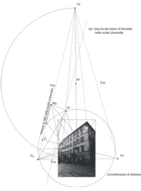
Fig. 3. The four steps provided by the methodology used for the survey of ur-ban curtains, defined as “monoscopic photogrammetric survey”: 1 survey on the street with total station, 2 identifi-cation of recorded points on the pho-tographic image, 3 straight and scaled the photo, 4 photomosaic of the streets façade.
count the multiplicity of functions in Old Town. The guiding idea for the development of strategies to restore value to the city’s old heart cannot ignore the fact that the actions to be taken must address several essential aspects of the urban area: attractiveness, ac-cessibility, liveliness, environmental quality and safety. In general, the attractiveness of an old town centre can be defined as the ability to appeal to an ample number of persons. From a strictly commercial point of view, attractiveness has to do with the suitability of a sales point, or set of sales points, to appeal to the greatest number of customers and induce them to purchase. It is obvious that such a capability does not only depend on the stores but also on elements that are external to the businesses. It involves the entire context of the urban environment that is, to all effects, a social communica-tion system. The accessibility of an urban area has to do with the ease with which it can be reached from the outside. It is clear that the layout of the streets and the organisation of traffic flows, as well as the parking plan and the network of public services, have a heavy impact on accessibility to the centre and the attractiveness of the commercial offering, even if an increase in acces-sibility should not be considered a sufficient condition, in itself, to strengthen the attractiveness of the urban centre.
Environmental quality has to do with the totality of the urban environmental factors that contribute to making a place fully liveable and creating feelings of well being in those that visit and live there.
Starting from this premise, first of all we want to give you some information on the context of which we have dealt with: Parma is a city of 180,000 inhabitants lo-cated in northern Italy between Bologna and Milan. City of Roman foundation, it is set on the east-west axis of the Via Emilia and is cut vertically into two parts by the river Parma.
An intervention for the purpose of renewing more than just the commercial aspects of an entire urban centre must be structured on different levels through a series of studies of specific factors of the urban and archite-ctural context in the complexity of its relationships that lead to a definition of the spaces, elements and services that must characterise the NSC.
On the other hand, since “…cities do not grow by virtue of their own inscrutable instincts, but are constructed, piece by piece, by individual inhabitants…” (Rykwert J, 2002), any intervention on them, or their important parts, requires knowledge of the historical, sociological, political and economic dynamics that have determined the current urban layout, just as it is essential, from a methodological point of view, to know and understand these dynamics before planning any future develop-mental interventions.
An organic intervention plan to create an innovative sup-port infrastructure not only for the existing businesses of the old town centre, but also and especially, to support its character as a place of residence and social and cul-tural aggregation, requires the synergistic collaboration of several different disciplines. An urban and architec-tural analysis that, by starting from in-depth knowledge of the current state of fact, in qualitative and, especially, quantitative terms, both dimensional and formal, could suggest guide lines for a series of commercial, urban and social renewal interventions in the area, which can-not help but emerge from a multidisciplinary analysis and in-depth knowledge of the context, itself.
These include, first, an analysis of the context, which has to do with urban elements relative to the street sys-tem, pedestrian areas, accessibility and the location of parking lots, urban furnishings and relative functions, as
well as knowledge of the current urban structure un-derstood as the outcome of a long historic stratification that has led to its present-day formal layout and image. In this context, it is particularly important to analyse the existing urban attractions and spaces for social interac-tion, as well as their formal, structural and organisatio-nal characteristics.
METHODS
As of now, given the vastness and complexity of the sus-pect showed the impossibility of applying a consolidated method of survey, but the opposite was the ambition to define one, or rather, to define a plot on which a plurality Contextual methods in different disciplines.
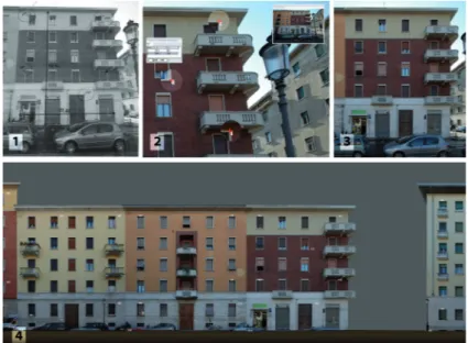
In regard to the strictly architectural and urban context, the decision was made to conduct a broad survey that went beyond an exclusively planimetric logic based on Fig. 4. The rectified images and the graphic drawing of the façade of Via Bixio: first part.
destinations of use, density and abstract type classifi-cations, which do not identify the qualities of a place or explain the rules and relationships between the parties that is indispensable to both the public and private sec-tors when correctly planning interventions.
For this reason, we started by surveying and tracing the commercial streets on an urban scale as the fundamen-tal first step in collecting and identifying environmenfundamen-tal and geometric data.
The precondition for a scrupulous survey is the usual acquisition of historic and archival information. This al-lows delineating various survey approaches and lines of investigation related to the specificity of the place: the image of the city’s streets; an overview of its public spaces; key features of the city’s streets; key features of the city’s architecture.
In order to obtain integrated and precise knowledge of
the object of our research, we employed a quick urban survey method based on the integration of survey tools and techniques that are sophisticated, yet simple and fast, such as digital cameras, total stations and projecti-ve transformation software that provided a surprojecti-vey of all the urban façades that characterise the principal shop-ping streets of the old town centre.
The methodology used for the survey of urban curtains can be defined as “monoscopic photogrammetric sur-vey”.
The correct starting point upon which this method is ba-sed is that you can compare, once eliminated the distor-tions and aberradistor-tions caused by the photographic lens, the photographic image to a rational perspective. Special software can identify the vanishing points and then transform the image as if it were acquired with the plane of the sensor or the negative of the camera
(comparable to prospective plane) parallel to a reference plane chosen in the photo itself.
The results it is a central perspective in which it rema-ins only one vanishing point; assuming that the picture perspective is vertical and coincident with the main flo-or of the facade remains the convergence of hflo-orizontal straight lines perpendicular to this plane.
For some objects, typically those of architecture, con-sisting of several plane surfaces parallel to each other, we need to scale the different portions lying on different planes using measures known in advance, but we can still get an image, rectified and appropriately scaled, metrically correct.
In the first step of acquisition and realignment, we de-cided to use two different methods using both method offered by the software chosen (RDF software by IUAV), in order to verify their working options, their resulting Fig. 5. The rectified images and
the graphic drawing of the façade of Via Bixio: second part.
precision and effectiveness in the specific case of histo-rical buildings curtains.
The projective transformation, performed in a semi-au-tomated software, can be set by geometrical or analyti-cally way (calculation of parameters with the method of least squares).
With the first method, geometric rectification, defining the vanishing lines and specifying two measures, which we have observed directly on the façade, the software rectifies and scales the photo of the building to survey. With the method based on the points rectification are enough some reference points (least 4 points), that could be imported directly from the topographical ins-trument or inserted manually, to rectify and scale the photo.
After the capture of photographic shots with digital cam-era (Nikon D70) it was essential a preliminary opcam-era-
opera-tion: the elimination of optical distortion Optical distor-tion should not be confused with perspective distordistor-tion, it derives from the lens spherical aberration and from the way and the accuracy with which the lens has been manufactured.
To capture, in a single frame, the urban curtains in all their height we used a wide-angle (photographic lens SIGMA 10-20 mm DC). This is necessary to have a ver-tical measures related to all photos in the geometric rectification but it can cause some optical deformation to images; straight lines can become curves and a flat surface can take on the familiar ‘barrel’ or ‘cushion’ ap-pearance.
So we first process the images through a faster method, based on an algorithm which can read the Exif data of the photos and quickly abate the common types of opti-cal deformation in wide-angle.
Now it has been possible to proceed to the elimination of perspective distortion and to the straightening-up of photographs.
If the methodology that needs only two measures is very fast and simply for the geometric rectification of a single frame we found that it present many problems during the second step, the mosaicing of the photograms beca-use of the lack of control points. In this job it is impos-sible to take the entire facades of a street in just one photograph, so the mosaicing become an indispensabile step but very problematic especially when the road is sloping.
Not having available a control points net widespread throughout the street prospectus, each photogram is superimposed on the preceding using two or more common points. But this means that one small error is transmitted to all successive photograms and it is
multi-Fig. 6. The rectified images and the graphic dra-wing of the façade of Via Bixio: third part.
Mazzini, Piazza Garibaldi, Via Farini, Via XXII Luglio, Via Repubblica.
A more careful survey was made of the façades of the-se streets, bathe-sed on the rectification of photographs, in order to reconstruct the urban image in its entirety; from the recognition of a peculiar image, and how it is expressed, derived from the reading and analysis of the building curtain as a whole and its key features, it is possible to extrapolate indications on which to base the subsequent guide lines for the reconstruction of a uni-tary, and highly characterising image for the Oltretorren-te and Old Town Centre NSCs.
Once we identified the principal shopping streets to be subjected to specific surveying and analysis, we also identified their “area of influence,” which allowed us to draw a perimeter around several sectors on which we performed a thematic reading of the context for the
purpose of in-depth knowledge of the current urban structure.
Multiple criteria were used to identify homogeneous areas: On the one hand, their relationship with the shop-ping street from a both a “material” point of view, i.e., the infrastructure of the urban fabric strictly connected to the urban morphology, and from the “immaterial” point of view of the identification of a series of fruitive paths that guide users as they follow the streets of the town centre.
On the other hand, the identification of several areas characterised by the spontaneous concentration of spe-cific merchandise categories that distinguish parts of the city through references to specific themes or formal specificities that have led, for example, to several shop-ping streets differentiating themselves based on their belonging to a specific category.
plied proportionally to the number of photograms in the mosaic.
Using the analitic method with the points downloaded from the total station we have a very high level control on the geometry of the street during the mosaicing be-cause each photogram is positioned independently, ac-cording to points which are measured in the survey. In this way errors are not reproduced, but are limited, no matter how many photograms are involved.
The survey of each street was made using a total station (Trimble 5600) and setting many points on each side-walk. From this station points we can measure at least 4 target for each facade.
The last step was the digitalisation and the vectorializa-tion of the images importing them in a Cad software. For the surveying and representation of the shopping streets, the choice fell to the traditional plan and eleva-tion view representaeleva-tion, with typical urban scale detail, treating the building curtain in a unitary way. The result was a representation of the city without fragmentation, following a single reference system and with a homoge-neous scale of reduction and graphic language. The principal shopping streets were classified on the ba-sis of the density of presences, thus identifying a series of streets of varying importance, always established on the basis of the density of the commercial presences ca-tegorised as public businesses, large or medium-large sales structures and neighbourhood stores.
Specifically on the basis of this first classification, seve-ral streets were identified as the focus of analysis, defi-ning homogeneous areas around them that are subject to the influence of the main streets and tend to gravitate towards them, in some cases even developing a particu-lar and autonomous thematic character.
These streets are identified as: NSC OLTRETORRENTE: via D’Azeglio, via Bixio / piazzale Corridoni, via Imbriani; NSC HISTORICAL CENTER: via Garibaldi, Via Cavour, Via
The image of the city can be defined / identified as the result of mental construction and it is based on image analysis of the various formal and structural compo-nents that have historically characterized the morpholo-gy of the fabric of buildings, both on the hierarchy of val-ues that the various building types have acquired over time, especially in the relationship between that which is commonly identified as “architecture” and “construc-tion of context.”
Survey, through the codes of representation is how to make manifest the result of the cognitive process put in place in order to identify, recognize, report, describe the set of values in fact suspected to be that sum of formal and structural invariants governing the definition of urban.
The theme of the recognisability of the formal image of an urban context acquires increasing importance
beca-use it must be linked to the problem of enhancing the value of, and protecting, a cultural heritage that must be able to be expressed through solutions that construct renewed images that are congruent with those linked to the history of the object of the intervention.
From this point of view, the surveying of street façades is one of the most direct ways to analyse the “stylistic level,” i.e., the language with which the single pieces of the city manifest themselves to the external eye, and it is an indispensable component for investigating the manner in which, beyond the specific building types, the compositional and formal language, which is an expres-sion of determined historical periods, has constructed that set of “variants” that constitute the individuality of an urban context: streets, squares, road widenings, ave-nues, etc.
Obviously, the survey must not limit itself to returning
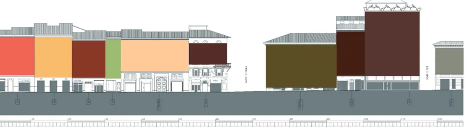
composite drawings of a set of façades in the form of a simple “orthogonal projection” on the vertical plane. The image of a street or square is bound to the confor-mation of its spatial contents, the rules that have de-termined its dimensions beyond typological choices, the materials used in the architecture of the façades and in the construction of shop windows and the quantity of light that the materials, especially the glass of store fronts, absorb or reflect. In fact, the “perspective spa-ces” are harder to grasp. If, as Swift has said, “vision is the art of seeing the invisible,” the drawing must seek to record and express even the so-called “existential space,” to reveal the typicality of the place that is not immediately recognisable, and a two-dimensional rep-resentation is not always sufficient for that purpose. In detail, the analysis of the shopping streets and homo-geneous surrounding neighbourhoods, is structured into Fig. 8A. Street façades analysis: A-photo
different levels and categories of reading the context: from an overall reading of the building curtains (on the primary shopping streets) to the reading of each single building in the neighbourhood, the collection (on speci-fic, suitably structured sheets) of a series of data linked to the size of the building, the period in which it was built, a functional analysis, a typological and architectu-ral/formal analysis, through to a more detailed reading of the signs of the store furnishings in relation to the dimensions of the commercial units, their merchandise categories, and the types of shop windows, signs and awnings for the purpose of constructing an abacus of key features, understood both in a historic-monumental sense, and thus subject to protection, as well as in the sense of “involving critical issues”.
An analysis of the relationship between the commerci-al impact in a determined section and the relative
pe-destrian space in front, has revealed a direct correla-tion between these two factors: while the cause/effect relationship is not necessarily unique, the greater the available pedestrian space on the edge of the street, the greater then shopping development on the ground floor. Another type of analysis performed on the principal streets has to do with the exposure of the façades to the sun, which in strict relationship with the shade and the expected thermal comfort level in various periods of the year, leads to various indications for the design of sunscreens for shop windows but also a better unders-tanding of the dynamics connected to the aggregative phenomena of the users of these areas.
The analysis phase of the strees façades resulted in the drafting of guidelines for the design of elements to en-hance the value of public spaces for the purpose of the on-going liveability of those spaces.
The guidelines for the design of elements for the use of public spaces, intended to continue living space, cur-rently under development, ensuring a strong integration between the two urban contexts, while recognizing the diversity of different areas.
The purpose is to create a network of open spaces that are configured as an organism capable of, on the one hand, putting the existing architecture into relation and relating with it and, on the other hand, creating the pre-conditions for giving them a new sense that will attract people to come together and spend time there. Particular attention has been paid to the open spaces. In fact, they are considered to be true and proper open rooms and have been analysed as such through a dual subjective/objective register that anticipates the use of a series of quality indicators that range from the its shape, to its size and, from them, to the dimensional relations-Fig. 8B. Street façades analysis: B-geometry
hip of the altimetric plane between the public and urban space. Relative to intervention design guidelines, these have to do with the identification of standards for urban connections, with special reference to commercial ma-terial; guidelines for the design of public spaces (both open and infrastructures).
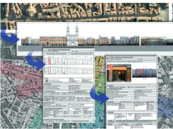
At the conclusion of this comprehensive and deepen re-search, based on the finding of the curtains of the build-ing trade paths present in the centre of Parma, it is in the process of structuring a database capable of reporting all information collected: both those on the urban image, as has been characterized along ahead of themselves, whether more detailed information relating to individual buildings that make up the curtain wall construction, but especially those relating to individual business units. The single files containing the data revealed that spe-cific analysis of buildings and commercial units are
structured as a mixed element, photographic / graphic / alphanumeric, which are protected by a password, so that for the external user, the information system so structured is available without changing the content, while the qualified technicians can unlock data sheets and update and integrate them, so as to achieve a flex-ible database and updated as needed and transforma-tions, always subject to the dynamics which are very fluid and fast in trade.
Urban survey, used in this study as an essential tool for analysis and knowledge of the typical image of a city and particularly of its commercial streets, stands as an instrument of knowledge of a highly urban context char-acterized as that of the old town of Parma, in which the commercial aspect, spontaneously structured over the years, it is of great impact, not only of a formal, urban image in the characterization, but also in the definition
of the use and enjoyment of the historic city center from the social point of view, another crucial aspect to be taken into account in formulating strategies for revitali-zation of historic urban areas.
Issues strongly supported by other highly urbanized en-vironments, are in fact, those relating to the depopu-lation of city centers and especially to the decrease in residential functions in the urban center.
Strengthening its commercial structures, from a care-ful and thorough analysis of issues on which action is strategic, it appears to be one of the strategies imple-mented by the Municipality of Parma, not only to en-hance and upgrade the trade center, but also groped to bring the density function in this context, so structured, recreating the historic combination house / shop that has defined, for centuries the urban structure of Italians city centers and not only of Parma.
CONCLUSIONS
We have used this type of analysis and definition of in-tervention guidelines, which are linked to the theme of shopping, to intervene in highly characterised and iden-tified contexts such as those of Italian old town centres, which are known for their very well-defined and iconic images, acting on them from the point of view of furt-her strengthening them or, ratfurt-her, relying on this strong formal characterisation to exploit and emphasize their peculiarity and harmonising the identifying elements to achieve an even more marked identification between the landscape of the old town centre and the shopping streets that structure the urban environment.
The concept of conservation of the historical context of the city and of its transformation, seemingly opposite, in fact conceptually merge with the conviction that the preservation of a historic center must be expressed
through its transformation not so much physically but especially functional rather in revitalization and en-hancement of existing spaces, both public and private, open and built.
The contradiction of terms is therefore only apparent and it is the approval of citizenship that expresses the need to continue to identify themselves in an historic space, formally and structurally very characterized, but which offers services and functions in line with current needs.
The requirements related to trade, which have been an-swered in recent years, with the construction of several shopping centers, including thematic, newly built (artifi-cial, therefore) in the more remote areas, find answers, even in areas of the Old Town through systematization of the existing structures along major trade streets, en-hancing and strengthening the structures already
em-bedded in the historic city in a spontaneous, natural way, building on the established urban walks, already inter-nalized by the citizenship, part of the feeling of identifi-cation in the town of affiliation.
In Italy, this type of approach to redevelopment and revitalization of historic centers, that has already been applied and tested in other geographical contexts (Eu-ropean, Asian Americans) and based not only on physi-cal interventions for the conservation of buildings and historic places, but mainly on the exploitation and func-tional reorganization of the tradifunc-tional patterns of trade, is fairly recent and original as it is based on a set of minimal intervention in the physical sense, applying mainly aimed at strengthening specific organizational strategies, support and enhancement to what already exists, doing careful work of mending and tissue regen-eration of the historic and consolidated center, and in Fig. 8D. Street façades analysis: D-full and empty spaces.
particular of the open public spaces, connection always based on a careful and thorough knowledge of actual
conditions of existing buildings and characteristic of the urban image, which it defined.
Fig. 11. Perceptive analysis of the flooring and of the main street furniture present into the trades spaces.
Fig. 9. Data sheets for every single units. Fig. 10. All data is organized in an information system that allows to find information about each building and each store from the aerial photo.
NOTE
[1] Mumford L, 1961, La città nella storia, Milano
[2] Lynch K, 1964, L’immagine della città, Padova
[3] Cavallari Murat A, 1968, Metodi e ricerca in tema di rioni storici. Rinnovamento nel rili-evo urbanistico-architettonico, Torino
[4] Benevolo L, 1978, Storia del-la città, Bari
[5] Arnheim R, 1981, La dina-mica della forma architettonica, Milano
[6] Docci M, Maestri D, 1984, Il
rilevamento architettonico: sto-ria, metodi e disegno,Bari [7] Coppo D, 1984, “Il rilievo dei centri storici tra obiettività metodologica e finalizzazione critica” in Proceedings Diseg-no – rilievo critico e coDiseg-noscenza storica, Lerici
[8] Romano M, 1993, L’estetica della città europea, Torino [9] Giandebiaggi P, 1995, “Rappresentazione automatica e monitoraggio dell’ambiente urbano” in La città sostenibile, Parma
[10] Baculo Giusti A, 1996, Na-poli al quattromila, NaNa-poli
[11] Storchi S, 1998, La città fra storia e progetto, Reggio Emilia [12] Aymonino C, 2000, Il signi-ficato delle città, Venezia [13] Giandebiaggi P, 2001, “Il rilievo dell’immagine urbana: elementi e tipologie caratteris-tiche nei percorsi principali” – in Proceedings Rilievo e forma urbana. Il disegno dei portici. Il disegno della città, Torino [14] Coppo D, Davico P, 2001, Il disegno dei portici a Torino – Architettura e immagine urbana dei percorsi coperti da Vitozzi a Piacentini, Torino
[15] Storchi S, 2001,Recupero,
riqualificazione e riuso della cit-tà, Milano
[17] Rykwert J, 2002, L’idea di città, Milano
[18] AAVV, 2003, Coneixer celona. Atlas Comercial de Bar-celona, Barcelona
[19] De Botton A, 2006, Archi-tettura e felicità, Parma [20] Coppo D, Osello A, 2006, Il disegno dei Luoghi e Mercati a Torino, Torino
[21] Apollonio F, 2007, I colori di Cesena. La scena urbana della città, Cesena
[22] Benjamin W, 2007, Imma-gini di città, Torino