DOTTORATO DI RICERCA IN INGEGNERIA CIVILE PER L’AMBIENTE ED IL TERRITORIO
XI Ciclo - Nuova Serie (2009-2012)
DIPARTIMENTO DI INGEGNERIA CIVILE,UNIVERSITÀ DEGLI STUDI DI SALERNO
A METHODOLOGICAL APPROACH FOR
THE ANALYSIS OF SHALLOW LANDSLIDES
IN NON-COLLAPSIBLE SOILS
UN APPROCCIO METODOLOGICO PER L’ANALISI DELLE FRANE SUPERFICIALI IN TERRENI NON COLLASSABILI
MARIANTONIETTA CIURLEO
Relatore:
PROF. ING.LEONARDO CASCINI
Correlatori:
PROF. ING.GIUSEPPE SORBINO PROF.DOTT.SILVIO DI NOCERA
ING.GIOVANNI GULLÀ
Coordinatore
PROF. ING.LEONARDO CASCINI
U NIV
_______________________________________________________
i
On the front cover: Typical examples of shallow landslides in fine-grained soils. Catanzaro, Calabria (Italy).
A METHODOLOGICAL APPROACH FOR THE ANALYSIS OF SHALLOW LANDSLIDES IN NON-COLLAPSIBLE SOILS
__________________________________________________________________ Copyright © 2012 Università degli Studi di Salerno – via Ponte don Melillo, 1 – 84084 Fisciano (SA), Italy – web: www.unisa.it
Proprietà letteraria, tutti i diritti riservati. La struttura ed il contenuto del presente volume non possono essere riprodotti, neppure parzialmente, salvo espressa autorizzazione. Non ne è altresì consentita la memorizzazione su qualsiasi supporto (magnetico, magnetico-ottico, ottico, cartaceo, etc.).
Benché l’autore abbia curato con la massima attenzione la preparazione del presente volume, Egli declina ogni responsabilità per possibili errori ed omissioni, nonché per eventuali danni dall’uso delle informazione ivi contenute.
i
INDEX
INDEX ... i index of figure ... iv index of tables ... xi SOMMARIO ... xiii ABSTRACT ... xv ACKNOWLEDGEMENTS ... xviiAbout the author ... xix
1 Introduction ... 1
2 Litterature review on shallow landslides in fine grained soils ... 5
2.1 Definition and types ... 6
2.2 Involved soils ... 9
2.3 Input data and methods of analysis in the scientific literature18 3 Reference frameworks for an advanced analysis of the open questions ... 27
3.1 Landslide classification ... 27
3.2 Landslide inventory ... 32
3.3 Methods of Susceptibility zoning ... 35
3.4 The Guidelines of JTC-1 ... 39
3.5 The multi-levels approach ... 42
3.5.1 Examples of small and medium scale ... 45
3.5.2 Examples of analysis on large, detailed and REV scale .. 49
4 The proposed approach ... 53
4.1 General framework ... 53
4.2 Applicability to shallow landslides ... 56
4.2.1 Small and intermediate scale ... 57
4.2.2 Large and site scale ... 59
5 The test area ... 61
5.1 The available database ... 63
5.1.1 Ground water system ... 65
5.1.2 Landslides inventory ... 66
5.1.3 In situ investigation and laboratory tests ... 67
5.2 The monitored test site ... 70
ii
6.1 Geological setting of the Calabria Region ... 73
6.2 Geomorphological setting of the Calabria Region ... 78
6.3 The Catanzaro Graben and the Crotone study area ... 79
6.4 Small scale analysis of the study area ... 83
6.4.1 Phase I ... 83
6.4.2 Phase II ... 91
7 Medium scale analysis ... 97
7.1 Phase I: test area and input data ... 97
7.1.1 Geology and tectonics ... 98
7.1.1.1 The Geological map of the Calabria region (1:25,000 scale) ... 102
7.1.1.2 New element for the morphological and lithological structure ... 103
7.1.2 Landslides inventory map (1:10,000 scale) ... 105
7.1.3 DTM ... 108
7.2 Landslides predisposing factor and Neo-tectonic evolution of the study area ... 109
8 Slope evolution models at large scale ... 113
8.1 Evolution of the morphological hollows ... 113
8.2 The landslides classification and mechanisms ... 119
8.2.1 Shallow landslides classification ... 120
8.2.2 Slope evolution models for shallow landslides ... 122
8.3 The geotechnical data set ... 128
9 Input data for the geotechnical analysis ... 131
9.1 General feature of the clayey covers ... 131
9.2 Micro, meso and macro structures ... 135
9.3 Geotechnical and hydraulic properties of the soil ... 137
9.3.1 Grain size distribution and index properties ... 138
9.3.2 Shear strength properties ... 140
9.3.3 Hydraulic properties ... 143
9.4 Calibration and validation of the hydraulic properties ... 147
9.4.1 LAB parameters ... 147
9.4.2 Literature review on SWCC for cracked soil ... 151
9.4.3 Proposed conducivity hydraulic function ... 153
10 Numerical modeling and results ... 159
10.1 Stability analysis at slope scale-adopted procedures ... 159
10.1.1 Selection of the most representative slope sections ... 160
10.1.2 Analysis and results ... 172
iii
10.2.1 Input data ... 173
10.2.2 Results of TRIGRS analysis ... 175
10.2.2.1 Preliminary parametric analysis (1:5000 scale) ... 176
10.2.2.2 Analysis based on the triggering mechanisms (1:5000 scale) ... 178
10.2.2.3 Analysis based on in situ investigation and triggering mechanisms (1:5000 scale) ... 181
10.2.2.4 Analysis based on in situ investigation and triggering mechanisms (1:1000 scale) ... 184
10.2.3 Results of TRIGRS-unsaturated analysis ... 187
11 Consideration and future developments ... 189
11.1 Small and medium scale analysis ... 190
11.2 Large and detailed scale analysis ... 191
11.2.1 A methodological proposal to develop the cover thickness map ... 193
11.2.2 Detailed and REV scale ... 195
11.3 Applicability and future developments ... 196
11.3.1 Applicability of the proposedprocedures (New Zealand case study) ... 196 11.3.2 Future developments ... 199 12 Concluding remarks ... 203 References ... 205 Appendix A ... 217 Appendix B ... 221
iv
INDEX OF FIGURES
Figure 2.1 Typical examples of shallow landslides in clay soils. (a) New Zealand (Brooks et al. 2002); (b) Catanzaro (2004). ... 7 Figure 2.2 Multiple rainfall-triggered shallow landslides. (a) Air photo of July 1977, Wairarapa, North Island, New Zealand (Crozier, 2005); (b) Air photo of events in New Zealand in February 2004 (Hancox & Wright, 2005); 3D view from Google Earth, March 2010, Catanzaro, Calabria, Italy: (c) general view (d) typical phenomena in a morphological hollow. ... 8 Figure 2.3 Stabilising effect of close planting of pines and riparian planting of poplars, Gisborne District, North Island, New Zealand (Crozier 2005)... 9 Figure 2.4 A family of collapsible soils (Rogers 1994) ... 10 Figure 2.5 Ordered water weathering: a) A molecule of water, b) water molecules become oriented, c) water is ordered around clay fragments and remains disordered in bulk water, e) renewed wetting builds up another layer of ordered water ... 13 Figure 2.6. SEM images from grains of two different fine grained soil samples: a) natural (intact) silt sample, b) silt sample degraded in laboratory (Gullà et al., 2008)... 14 Figure 2.7 (a) The XRD patterns of silt samples degraded in laboratory and natural (intact) silt samples whole-rocks, (b) The XRD patterns of the air dried (AD) and ethylene glycol solvated (GLY) <2 μm fraction specimens of silt samples degraded in laboratory and natural (intact) silt samples (Gullà et al., 2008) ... 15 Figure 2.8 Oedometer curves of intact, weathered and reconstituted clay (Gullà et al., 2006) ... 16
Figure 2.9 Stress-displacement relationships of intact and weathered specimens compared with residual shear strength (Gullà et al., 2006) ... 17 Figure 2.10 Strength envelopes of intact and weathered clay compared with reconstituted and residual envelopes ... 18
v Figure 2.12 Instrumentation layout. Measurements in meters (Lim et al., 1996) ... 19 Figure 2.13 (a) Generalized soil profile through the instrumented slope. (b) Ground surface condition on the instrumented slope (Lim et al., 1996) ... 20 Figure 2.14 In situ matrix suction measurement in the slope with canvas over grass, grass and bare surface (Lim et al., 2006)... 20 Figure 2.15 Geological section of slope with location of slip surface (Eigenbrod and Kaluza, 1999) ... 21 Figure 2.16 Slope stability analysis. (a) Factor of safety versus angle of friction. (b) Factor of safety versus pore-water pressure coefficient at slip surface (Eigenbrod and Kaluza, 1999) ... 22 Figure 2.17 Block diagram of soil slip and grain size distributions (Antronico et al., 2001) ... 23 Figure 2.18 Engineering geological unit map (Meisina, 2006) ... 24 Figure 2.19 Sensitivity plot for the infinite slope equation with central soil depth equal to 1.0 m (Borga et al., 2002) ... 25 Figure 3.1 A simple classification of landslide (Blong 1973) ... 28 Figure 3.2 Slope movement types and processes (Varnes 1978) ... 29 Figure 3.3 Geotechnical characterisation of slope movements (Leroueil et al., 1996): (a) different stage of slope movements (b) schematic slope movement characterization (c) types of material considered in the characterization ... 32 Figure 3.4 Overview of techniques used to landslides inventory. H, M, L indicated the applicability of each technique for small, medium, large and detailed mapping scales. (H=highly applicable, M=moderately applicable, and L=Less applicable) (van Westen et al., 2008) ... 33 Figure 3.5 General framework of landslide risk management (Fell et al., 2008a) ... 36 Figure 3.6 (a) Geological map of Salerno province; (b) Part of landslides inventory map and classes of landslides intensity and magnitude; (c) Susceptibility zoning map at small scale (Cascini 2008) ... 45
Figure 3.7 Preliminary susceptibility zoning at medium scale for the area framed with the black square in the Figure (Cascini 2008) ... 46
Figure 3.8 Procedure used to identify and classify areas susceptible to shallow landsliding events at a regional scale (Gullà et al., 2008) .. 48 Figure 3.9 Relation between structure and material behaviour (Picarelli 1991 and D'Elia et al., 1998) ... 52
vi
Figure 4.1 General framework for landslides susceptibility map ... 55
Figure 4.2 (a) Compilation of geological data concerning the Petilia-Sosti fault zone in Northern Calabria.(van Dijk 1991) ... 58
Figure 5.1 Test areas at different scales... 62
Figure 5.2 An example of PAI landslides inventory map ... 65
Figure 5.3 In situ investigations with steel bar ... 67
Figure 5.4 Guelph permeameter ... 70
Figure 5.5 Monitoring station ... 71
Figure 5.6 Jet Fill’ tensiometers layout ... 72
Figure 6.1 Geological sketch-map of the Central Mediterranean area, with geological section at the bottom. At the top, location of the study area, and tectonic simplified sketch of the Calabrian Arc (Tansi et al., 2007) ... 74
Figure 6.2 Calabrian-Sicilian rift-zone (Monaco and Tortorici, 2000, mod.). Crustal earthquakes (depth < 35 km) since 1000 a.d. are also shown (Postpischl 1985; Boschi et al., 1995)... 75
Figure 6.3 (A) Late Pliocene-Early Quaternary block-segmentation of the Calabrian Arc (Ghisetti, 1979, modified). Black lines indicate the main faults. (B) main morpho-neotectonic structures and uplift rate in Calabria during the Quaternary. Legend: g) and f) average uplift rate during 1my and 40 ky-125 ky. e), d), c), b), a) main structural features ... 76
Figure 6.4 Litho-structural map (Sorriso-Valvo et al., 1996 mod.) ... 78
Figure 6.5 The test area at 1:100,000 scale ... 80
Figure 6.6 Geological sketch-map of Crotone Basin with location of the study area. The two NW-trending shear zones that bound the basin should be noted (Massari et al., 2002) ... 81
Figure 6.7 Litho-structural map of mass movements of Catanzaro Graben, 1:50,000 scale (Antronico et al., 2001) ... 82
Figure 6.8 Landslides inventory map at 1:100,000 scale ... 84
Figure 6.9 Two examples of the regional geological map ... 85
Figure 6.10 The Lithological map of the test area ... 86
Figure 6.11 Schematic tectonic map of Northern Calabria (Van Dijk 2000) ... 88
Figure 6.12 Main drainage lines at 1:100,000 scale. Legend: from 1) to 22) see legend Figure 6.11, 23) main faults, 24) drainage lines ... 89
Figure 6.13 The sub-sectors A1, A2 and A3 ... 90
Figure 6.14 Landslide density map. I= landslides index, np=number of points, Aneig= neighbor area ... 91
vii
Figure 6.15 Quantitative map combination ... 92
Figure 6.16 Trionto basin ... 93
Figure 6.17 (a) lithology, (b) drainage density, (c) slope, (d) differential uplift. ... 95
Figure 6.18 Geo-morphological evolution map ... 96
Figure 7.1 Test area at 1:25,000 scale ... 98
Figure 7.2 Litho-structural and mass movements map of Catanzaro Graben, 1:50,000 scale ... 100
Figure 7.3 Geological map and structural section of the Catanzaro area in the central part of Calabria (Van Dijk and Okkes 1991) ... 101
Figure 7.4 Deep reflection seismic (AGIP) ... 102
Figure 7.5 Geological map of the test area ... 104
Figure 7.6 PAI landslides inventory map ... 105
Figure 7.7 Google Earth images... 106
Figure 7.8 Landslides inventory map and geological map of the study area ... 107
Figure 7.9 Comparison of the different DTMs. A) DTM 25x25 m cells, B) DTM 5x5 m cells ... 108
Figure 7.10 Geological map at 1:25,000 scale ... 110
Figure 7.11 Morpho-evolution model ... 110
Figure 7.12 Landslides Index. In blue deep seated landslides, in red shallow landslides... 112
Figure 8.1 St. Antonio and Magna Graecia University areas ... 114
Figure 8.2 A) Morphological hollows under investigation. B) Panoramic photos of St. Antonio and Magna Graecia Univeristy areas ... 115
Figure 8.3 Temporal sequence of Google Earth images. A) St. Antonio, B) Magna Graecia University ... 117
Figure 8.4 Google Earth images of St. Antonio area ... 118
Figure 8.5 Hollows evolution model ... 119
Figure 8.6 Shallow landslides classification. a) involved soils, b) different stages, c) types of movements. (Leroueil et al., 1996 mod.) ... 120
Figure 8.7 Evolution model of the slope for soil slip: (A) Rogers and Selby (1980); (B) Gullà et al. (2001) ... 123
Figure 8.8 Slope evolution model (MORSLE 1) ... 124
Figure 8.9 Slope evolution model (MORSLE 2) ... 125
Figure 8.10 Slope evolution model (MORSLE 3) ... 126
Figure 8.11 Spatial distribution of the triggering mechanisms ... 127
viii
Figure 8.13 Spatial distribution of in-situ investigations and soil stratigraphy ... 129 Figure 8.14 Shear strength properties ... 130 Figure 9.1 Conceptual model describing the development of primary, secondary and tertiary cracks, resulting from the build up of tensile stresses on drying (Dexter 1988) ... 133 Figure 9.2 Cracking pattern in a desiccated soil surface (Blight 1997) .. 134 Figure 9.3. Crack pattern at the soil surface. (a) soil with grass; (b) soil ploughed in spring; (c) cross-section showing the crack depth (Meisina 2006) ... 134 Figure 9.4 Pattern of fractures mesured in the test area ... 135 Figure 9.5 Metodological approach proposed for the geotechnical analysis (Picarelli 1991 and D’Elia et al. 1998, mod.) ... 136 Figure 9.6 The XRD patterns of silt samples degraded in laboratory and natural (intact) silt samples whole-rocks (Gullà et al., 2008) ... 137 Figure 9.7 Spatial distribution of in situ and laboratory test. 1) soil specimens taking, 2) monitoring station, 3) Guelph permemeter test ... 138 Figure 9.8 Grain size distributions ... 139
Figure 9.9 Trends of the main index properties with depth, in black available data, in red new acquisition data ... 139 Figura 9.10 Activity and plasticity chart. In black available data, in red new acquisition data ... 140 Figure 9.11 Strength envelopes of intact and degraded clay ... 141
Figure 9.12 Strength envelopes of degraded clay ... 141
Figure 9.13. Strength envelopes of natural degraded and artificially degraded clay ... 142
Figure 9.14 Typical soil-water characteristic curve features for the drying and wetting of soil (Vanapalli et al., 1996) ... 143 Figure 9.15 Soil water characateristic curves ... 144 Figure 9.16 (A) Soil sample after a first drying cycle in Richards pressure plate (B) Soil sample after wetting (C) soil sample after a second drying cycle in Richards pressure plate ... 145 Figure 9.17 Interpolated curves and experimental data, in table: the optimized fitting parameters ... 146 Figure 9.18 Hydraulic conducivity functions ... 147 Figure 9.19 Daily values of rain depth, temperature, pore pressure resulting from the tensiometers. “?” No available data (Gullà et al., 2004) ... 148
ix Figure 9.20 Reference section for modelling... 149 Figure 9.21 The SWCCs used in the first step of modelling ... 150 Figure 9.22 Results obtained by modelling. In black measured data, in green modelled data... 151 Figure 9.23 (A) Soil-water characteristics curve for fractured clay (1 mm @ 0.5 cm); (B) Soil suction versus hydraulic conductivity for a fractured soil (crack of 0.1 mm wide at 0.5 cm spacing between cracks)(Fredlund 2010) ... 152 Figure 9.24 Comparison between measured data (in black in figure) and modelled data (in orange) considering bi-modal SWCC ... 153 Figure 9.25 SWCCs and hydraulic conductivity functions for undisturbed and artificially degraded sample (car 1 and car1_degr) ... 154 Figure 9.26 Comparison between the proposed hydraulic conducivity function and the hydraulic conductivity function obtained for artificially degraded specimens... 155 Figure 9.27 Measured and modelled pore water pressure using the proposed conductivity function. (A) calibration, (B) validation .. 156 Figure 9.28 The proposed conductivity function (blue line) and Kfs
values obtained from Guelph test ... 158 Figure 10.1 The test area at large and detailed scale. DTM (5x5m cells) is available for the area framed with the yellow square, DTMs (5x5m and 1x1m) are available for the area framed with the green square. White lines represent sections used for the analysis of slope angle ... 160 Figure 10.2 (A) min, max and average values of slope angle for different sections. (B) The section n° 32 obtained using CTR and Lidar data ... 162 Figure 10.3 Sections considered in the modelling. (numbers specify depths in meters) ... 163 Figure 10.4 In-situ measured rainfall ... 167 Figure 10.5 Pore water pressure analysis: MORSLE 1 and MORSLE 2
... 168 Figure 10.6 Pore water pressure analysis: MORSLE 3 (A) two layers of soil, (B) three layers of soil ... 169 Figure 10.7 Slope stability analysis. (A) Available data set (B) Factor of safety versus cohesion ... 170 Figure 10.8 Slope stability analysis. Factor of safety versus friction angle.
... 171 Figure 10.9 Physically based models ... 172
x
Figure 10.10 Cartographic database. (A) DTM, (B) Slope, (C) zoom
Slope ... 174
Figure 10.11 Soil cover thickness map and TRIGRS results ... 177
Figure 10.12 Soil cover thickness map (numbers specify depths in meters) ... 179
Figure 10.13 TRIGRS results ... 180
Figure 10.14 Quantitative indexes (Sorbino et al., 2007) ... 181
Figure 10.15 (A) Investigated verticals, (B) soil cover thickness map obtained ... 182
Figure 10.16 TRIGRS results. SI=65% and EI=15% ... 183
Figure 10.17 SI and EI values versus cohesion and friction angle... 183
Figure 10.18 SI and EI values versus landslides mechanisms. ... 184
Figure 10.19 (A) and (B) soil cover thickness map ante in situ investigation and TRIGRS results, (C) Verticals investigated, (D) and (E) soil cover thickness map post in situ investigation and TRIGRS results ... 186
Figure 10.20 TRIGRS results. (A) Results obtained thought TRIGRS unsaturated, (B) Results obtained thought TRIGRS ... .188
Figure 11.1 Earth slides and earthflow of the landslide event of 15–17 February 2004, Wanganui-Manawatu, North Island, New Zealand (Crozier 2005)... .196
Figure 11.2 Typical morphology and dimensions of an individual landslide belonging to a multiple-occurrence regional landslide event. Notation: As is Area of scar; Ar area of runout deposit; Ls is length of scar; Lr length of runout; and D is depth modified (Crozier 1996)... 197
Figure 11.3 Soil cover thickness map (numbers specify depths in meters) ... 198
Figure 11.4 (A) TRIGRS result, (B) Google Earth image ... 199
Figure A1 AGIP Borehole (Catanzaro) ... 217
Figure A2 AGIP Borehole (near Crotone) ... 218
Figure A3 International stratigraphic chart ... 219
Figure B1 TRIGRS-unsaturated scheme (Savage et al., 2004) ... 227
xi
INDEX OF TABLES
Table 2.1 Reference papers for the analysis of shallow landslides in
non-collapsible soils. ... 6
Table 2.2 Criteria for collapse potential (Das 2007; Lutenegger 1988). .. 11
Table 2.3 Comparison between the index properties of intact weathered test materials (Gullà et al., 2006). ... 15
Table 3.1 Typical D/L ratio for various landslides types (Walker et al., 1997). ... 30
Table 3.2 Geotechnical classification in terms of soil fabric and pore-water pressure conditions (Hutchinson 1988) ... 30
Table 3.3 – Methods required for the inventory of existing landslides and characterization of potential landslides (Cascini 2008 mod.) ... 38
Table 3.4 Levels of activity required for susceptibility levels (Fell et al.,, 2008a mod.) ... 39
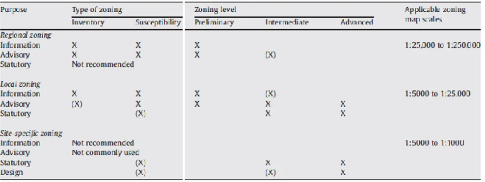
Table 3.5 Recommended types and levels of zoning and zoning map scales related to landslide zoning purpose (Fell et al., 2008a mod.) ... 40
Table 3.6 Examples of landslide susceptibility mapping descriptors (Fell et al., 2008a mod.) ... 41
Table 3.7 Methods, levels and types of zoning at different scales (Cascini, 2008). ... 43
Table 3.8 Scales and levels of analysis (Cotecchia et al. 2012 mod.) ... 44
Table 3.9 Suggested investigations for the geo-hydro-mechanical characterization (Cotecchia et al. 2012 mod.). ... 50
Table 6.1 Weights used by Del Monte et al. 2002. ... 94
Table 8.1 Common triggering or aggravating factors ... 122
Table 9.1 Boundary conditions applied at the ground surface. ... 149
Table 9.2 Hydraulic parameters. ... 150
Table 10.1 Max, min and average slope angle for a total of fifty sections analysed. ... 161
Table 10.2 Mechanical properties of soils. ... 163
Table 10.3 Pore water pressures measures (Cascini et al., 2010). ... 164
xii
Table 10.5 Mechanical properties of soils... 169
Table 10.6 Parameters used for modeling (Catanzaro). ... 187
Table 11.1 Parameters used for modeling (New Zealand) ... 198
xiii
SOMMARIO
Le frane superficiali in terreni a grana fine non collassabili sono tra i fenomeni naturali che, per il loro simultaneo verificarsi in aree di grande estensione, comportano spesso rilevanti perdite di suolo agricolo con conseguenti ingenti danni economici.
Nonostante la rilevanza delle conseguenze si deve, tuttavia, osservare che la letteratura scientifica, da sempre molto attenta all’analisi dei fenomeni franosi superficiali in terreni collassabili, ha dedicato fino ad ora un’attenzione molto limitata ai fenomeni superficiali in suoli non collassabili. Inoltre i pochi lavori disponibili si basano, infatti, sull’uso di approcci mono-disciplinari che forniscono utili indicazioni di carattere specifico, ma spesso introducono drastiche semplificazioni finendo per trascurare aspetti talora rilevanti. Aspetti, questi ultimi, che possono essere ben evidenziati soltanto facendo riferimento ad un approccio multidisciplinare e multi scalare (di tipo induttivo o deduttivo), come messo già in evidenza da alcuni autori in contesti geo-ambientali molto diversi tra loro sede di fenomeni franosi da mediamente profondi a profondi.
In un panorama così delineato, che risulta ricco in termini di approcci disponibili ma carente con riferimento alle frane superficiali in terreni non collassabili, la presente tesi intende fornire un contributo metodologico per l’inquadramento dei fenomeni oggetto di studio in un contesto organico di riferimento che consenta, allo stesso tempo, di fornire risposte specifiche ad alcuni dei molteplici e complessi quesiti che sorgono nell’analisi dell’innesco di questi fenomeni.
La metodologia proposta è stata testata e validata in un’area dell’Italia meridionale, sede di una franosità superficiale diffusa della quale si sono analizzati i fattori predisponenti e le cause innescanti passando dalla piccola scala, alla quale si sono utilizzati i modelli di tipo geologico, fino alla grande scala per la quale si è fatto ricorso alle analisi geotecniche sia su area vasta e sia a scala di versante.
L’approccio che si è privilegiato ha consentito, da un lato, di individuare nelle principali strutture tettoniche, nelle linee di drenaggio e nella litologia i fattori predisponenti l’evoluzione morfologica dei rilievi alle scale medio piccole, dall’altro di caratterizzare le frane a grande scala ed a
xiv
scala di dettaglio individuandone i meccanismi di innesco ed indagando alcuni aspetti specifici quali le proprietà meccaniche ed idrauliche del mezzo ed il regime delle pressioni neutre in sito.
In particolare, a grande scala sono stati individuati ed analizzati tre principali meccanismi di innesco che differiscono per caratteristiche morfometriche, entità dei volumi mobilitati e risultano non casualmente distribuiti sui versanti.
Successivamente, per i principali meccanismi di innesco, si è condotta una modellazione (saturo-parzialmente saturo) del regime delle acque sotterranee che ha fornito gli elementi di partenza per le analisi di stabilità che si sono svolte con i metodi dell’equilibrio limite e quelli fisicamente basati.
La validità complessiva dei risultati conseguiti evidenzia l’efficacia dell’approccio proposto e ne incoraggia l’uso anche in contesti geo-ambientali differenti da quello nel quale è stato testato e calibrato. A tale fine, al termine della tesi si sviluppano considerazioni di carattere generale che sono supportate da applicazioni preliminari a casi di studio ben noti nella letteratura scientifica internazionale.
xv
ABSTRACT
Shallow landslides in non-collapsible, fine-grained soils are natural phenomena which, due to their simultaneous occurrence over large areas, often cause agricultural production loss, with enormous economic damage.
Although the scientific community has offered in depth analyses of landslides in collapsible soils, shallow landslides in non-collapsible soils, have been paid very little attention in spite of their consequences. The few works available in scientific literature are based on monodisciplinary approaches which provide useful specific information on these phenomena; yet, at the same time, they also oversimplify the problem, often neglecting some relevant issues. Such issues can be best highlighted and addressed following a multisisciplinary and multiscalar (deductive or inductive) approach, as some authors have evidenced in very different geological and environmental contexts affected by medium to deep -seated landslides.
Within such a context, rich in approaches but lacking in references to shallow landslides in non-collapsible soils, the present thesis seeks to offer a methodological contribution for creating a homogeneous reference framework for the phenomena examined. At the same time, this work seeks to answer specific questions concerning the ways in which these phenomena are triggered.
The proposed methodology has been tested and validated over an area in southern Italy, in which shallow landslides are very frequent. The predisposing factors and the triggering causes have been analysed going from small scale, through geological models, to large scale by means of geotechnical analyses performed at slope and large scale.
On the one hand, this approach allowed to identify the predisposing factors of the morphological evolution of the reliefs in the main tectonic structures, drainage lines and in the main lithology; on the other hand it allowed the characterization of large scale and detailed scale landslides by identifying their triggering mechanisms, and by investigating specific aspects such as the hydraulic and mechanic properties of the soil and the pore water pressure regime in situ.
xvi
In particular, three main triggering mechanisms have been identified and analysed at large scale which differ in terms of morphometric characteristics, volumes involved, and which do not show a casual slope distribution.
Subsequently, a (saturated and unsaturated) modelling of groundwater regime for these mechanisms has been performed which provided the input data for stability analysis carried out through physically based and limit-equilibrium methods.
The overall validity of the results obtained highlights the efficacy of the methodology applied and recommends its use in geo-environmental contexts which differ from the one in which this methodology has been tested and validated. For this purpose, at the end of the present thesis, a series of general considerations have been discussed by making use of preliminary applications to internationally well-known case studies available in scientific literature.
xvii
ACKNOWLEDGEMENTS
At the end of this long, hard work, I am deeply grateful to the University of Salerno, where my research has been carried out, and to its teaching staff. In particular, I profoundly thank Professor Leonardo Cascini for making me join his team since the very beginning of my PhD programme. To him, I would like to offer my most sincere gratitude for guiding me and believing in me in spite of the difficulties encountered along the way.
A special thanks goes to Prof. Silvio Di Nocera, who encouraged me to deal with subjects I had not previously studied. Our constant conversations on my research topic gave me the opportunity to improve my knowledge.
I am also indebted to Ing. Gullà for his availability and competent advice despite the distance.
This work could not have been possible without the late Prof. Giuseppe Sorbino, whose memory I will always keep not only for our significant conversations on the topic of unsaturated soils, but mostly for teaching me never to give up in the face of difficulties.
I would like to acknowledge Ing. Foresta for his help during my laboratory analyses and in situ investigations. I will always remember the seven rounds of investigation programme we had in mid-August.
In addition, I am thankful to Prof. Ferlisi for his discretion and support. I would also like to thank all my friends from the Civil Engineering Department: Dario, Claudia, Livia, Giovanna and, Maria for always making me feel at home.
My gratitude also goes to all my friends at the CNR-IRPI in Cosenza, Sarah, Gino and Luigi. The latter deserves a special thanks for encouraging me to carry on with my research work with passion and for supporting me through hard times.
Last but not least, from the bottom of my heart, I am grateful to my parents and to Giusy and Domenico Andrea for their help, encouragement and trust. They all gave me a reason to keep going and never surrender.
xix
ABOUT THE AUTHOR
Mariantonietta Ciurleo graduated in Civil Engineering at the University of Calabria with 110/110 cum laude.
During her PhD programme she has developed research topics related to the analysis of predisposing and triggering factors of shallow landslides in fine-grained soils. These phenomena stand out for their spectacular features essentially when they occur as multiple landslides over large areas. To deepen these issues, she has undertaken training and research activities at the University of Salerno and some in leading national research Institutions such as CNR-IRPI in Cosenza (National Council Research). She attended also the postgraduate school LARAM (LAndslide Risk Assessment and Mitigation).
Mariantonietta Ciurleo si laurea in Ingegneria Civile, presso l’Università degli Studi della Calabria con la votazione di 110/110 e lode. Durante il corso di dottorato sviluppa tematiche inerenti l’analisi dei fattori predisponenti e delle cause innescanti le frane superficiali nei terreni a grana fine. Tali fenomeni risultano di grande interesse per il loro verificarsi come eventi multipli su aree di rilevante estensione.
Al fine di approfondire tali tematiche, svolge attività di ricerca presso l’Università di Salerno in collaborazione con il CNR-IRPI di Cosenza e frequenta i corsi nell’ambito della scuola di alta formazione LARAM (LAndslide Risk Assessment and Mitigation).
1 INTRODUCTION
Landslides are one of the main problems in the world due to their consequences in terms of both victims and damage to properties. Several databases discuss the relevance of the topic, as for instance MunichRe and OFDA/CRED; in particular, in the latter, mass movements are considered one of the most frequent natural disasters in the world. Among these, shallow landslides in collapsible soils often cause the worst consequences, since they occur simultaneously over large areas and because of their high velocity and great magnitude. These characteristics are essentially due to static liquefaction phenomena under critical rainfall condition or dynamic liquefaction (Olivares and Picarelli, 2003; Musso and Olivares, 2004; Wang et al., 2002), which are favoured by the metastable structure of the involved soils.
Given the relevance of the topic, many efforts have been devoted to study in depth several relevant topics, and scientific literature provides significant contributions on shallow landslides in collapsible soils.
Similar efforts have not been devoted to shallow landslides involving non-collapsible soils that are characterized by a totally different triggering and evolution stage and they do not suffer a large decrease in bulk volume as a consequence of failure. Nonetheless, they occur simultaneously over large areas and, after a certain period of time, they rapidly evolve causing the destruction of property as, for instance, in the case of New Zealand described by Crozier (2005).
Other significant examples are discussed by Aleotti et al. 1996, Meisina 2006, Lim et al. 1996, Eigenbrod et al. 1999, Pasuto 1998, Eden and Mitchell 1969, Roger and Selby 1980, Gullà et al. 2006, Gullà et al. 2008, Leoni 2008.
These examples confirm that, currently, the knowledge of these phenomena is poor and does not allow to classify, understand and properly manage the risk related to landslides. Moreover, as argued in the present thesis, these landslides are also underestimated since they are often considered as erosional processes in many scientific papers. Consequently, damage prevention is extremely difficult since
2
susceptibility and hazard maps are not properly developed or are not developed at all.
The present thesis aims at offering a contribution to fill this gap in the study of shallow landslides, particularly as the soil has been defined an inestimable resource by the European Union, and this kind of phenomena produces a consistent loss of this resource as Crozier et al (2005), Glade et al (2005) have confirmed with reference to other non-European countries such as New Zealand.
In particular, the purpose of this thesis is to offer a general framework of analysis based on a simple and coherent methodology which can clarify, and thus quantify, the predisposing and triggering factors of shallow landslides in clayey soils.
Particularly, chapter 2 reviews the scientific literature on shallow landslides in fine-grained soil summarizing definitions, types of phenomena, the general features of the involved soils, the methodologies used to analyse this kind of phenomena and the unsolved questions on several topics.
Chapter 3 discusses the reference framework for an advanced analysis of the open questions posed in chapter 2.
In Chapter 4, an integrated methodological approach to analyse this kind of phenomena is introduced. This approach goes from small to large scales and reinterprets what is currently available in literature in order to delineate and correlate the predisposing factors (at small-medium scale) to the triggering causes (at large and detailed scale) of shallow landslides. Chapter 5 presents a relevant case study of shallow landslides in fine-grained soils triggered by rainfall, devoting particular attention to the cartographic database; the landslides inventory; in situ investigations and laboratory tests used to characterize the geotechnical properties of soils. Chapter 6 describes a sample area, where the methodology proposed in chapter 4 is tested through a small scale analysis with the aim to identify and quantify the predisposing factors of the geo-morphological evolution of the study area.
Chapter 7 focuses on the use of a heuristic method to identify the morphological evolution of the reliefs identifying the necessary input data to develop a statistical analysis at medium scale.
Chapter 8 deals with the morphological evolution of hollows at large scale, and at detailed scale identifies three different triggering mechanisms on the basis of a landslide inventory, the available cartographic data base and in-situ evidence.
1. Introduction
3
Then, for each of these mechanisms the predisposing factors and the triggering mechanisms are analysed through evolution models at slope scale.
In Chapter 9, the quantification and validation of the triggering mechanisms identified in chapter 8 is pursued at slope scale through accurate geotechnical analyses. Particular attention is given to the hydraulic behaviour of the soil at both scales of macro and meso-structure.
Chapter 10 addresses the modelling of the triggering stage for shallow landslides induced by rainfall. Among the available approaches, uncoupled geotechnical models are used with particular reference to the modelling of pore water pressure and instability conditions. In particular, starting from the results of the analysis at slope scale, several modelling over large areas are carried out to investigate the limit-equilibrium conditions for each cell of the surface.
On the basis of the results obtained for the sample area, chapter 11 develops some general considerations within the general framework of Chapters 2 and 4, suggesting the necessary research developments to further investigate some relevant open questions.
2 LITERATURE REVIEW ON SHALLOW
LANDSLIDE IN FINE-GRAINED SOILS
The scientific literature on shallow landslides deals with multiple issues such as landslides morphometric characteristics, soil properties, kinematic evolution, duration and intensity of rainfalls. The papers analyzed in this thesis testify to the use of several approaches to study these phenomena and highlight the main role played by the collapsibility of the involved soils on the genesis, typology and kinematic evolution of shallow landslides (Campbell 1974, Cascini 2004, Cascini et al. 2005, Fannin 2000, Guzzetti et al. 2008).
Moreover, the papers dealing with collapsible soils address several issues such as the identification of the landslides source area, predisposing and triggering factors, mechanisms and modeling of the failure and post-failure stages and runout distance etc. (Corominas, 1996; Corominas et al., 2003; Pastor et al., 2003 a,b; Rahardjio et al., 2001; Wang et al., 2003). On the contrary, the scientific literature on shallow landslides in non-collapsible soils is much more complex due to several reasons essentially related to the heterogeneity of the available studies. Many of them usually deal with geological, geotechnical, hydrological, statistical issues; however, no studies or methods are available to analyze all the landslides-related factors such as landslide mechanisms, the soils involved and the triggering factors of shallow landslides. Other studies deal with the main aspects of the genesis, types, classification, methods of analysis but the landslides inventory, the susceptibility and hazard assessment are not adequately introduced and developed according to the most advanced procedures available in literature.
Given the lack of knowledge on the topic, the following sections provide the basic elements for a correct classification of landslides. Initially, the definitions, the typologies and the geotechnical properties of the phenomena involving non-collapsible soils are introduced; subsequently, the methodologies available in literature to analyse the triggering stage are discussed.
6
D
EFINITION AND TYPESAbout thirty papers listed in Table 2.1 deal with shallow landslides in non-collapsible soils. These works introduce different definitions and typologies of landslides that can affect different soils according to various mechanisms. The latter have been studied through the application of the different methodologies characterising different disciplinary approaches.
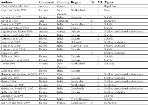
Table 2.1 Reference papers for the analysis of shallow landslides in non-collapsible soils.
SL: single landslide; ML: multiple landslides.
Indeed, and unsurprisingly, different definitions and different proposals for studying the same phenomena are available in scientific literature. However, despite the relevant differences concerning the differentiation and characterization of landslides, some general features can be recognized as argued by Crozier (2005), Gullà et al. (2004, 2005, 2006), Hicks (1995).
In particular, at slope scale, Campbell (1975) defines these phenomena as soil slips, and now, this term is used almost universally in scientific literature to indicate fast shallow instabilities phenomena involving
Authors Continent Country Region SL ML Types
Eden and Mitchell 1969 America Canada - Rapid flow
Rogers and Selby 1980 Oceania New
Zealand
North Island x Slide
Aleotti et al. 1996 Europe Italia Piemonte x Soil slip
Lim et al. 1996 Asia Singapore - x Earth flow
Crosta et al. 1997 Europe Italia Lombardia e x Soil slip
Pasuto and Silvano 1998 Europe Italia Veneto x Soil slip
Eigenbrod and Kaluza 1999 America Canada Ontario x Shallow translational and rotational
Antronico and Gulla 2000 Europe Italia Calabria x Soil slip
Antronico et al. 2001 Europe Italia Calabria x Soil slip
Borga et al. 2002 Europe Italia Dolomiti x Shallow landslides
Borga et al. 2002 Europe Italia Bacino di Vauz Shallow landslides
Antronico et al. 2004 Europe Italia Calabria x Soil slip
Brian et al. 2004 - - - x Shallow landslides
Gullà et al. 2004 Europe Italia Calabria x Soil slip
Sorriso-Valvo et al. 2004 Europe Italia Calabria x Soil slip
Crozier 2005 Oceania New
Zealand
North Island x Soil SLip
Gullà et al. 2005 Europe Italia Calabria
-Shakoora and Smithmyerb 2005 USA Ohio - x Shallow translational and rotational
Gullà et al. 2006 Europe Italia Calabria x Shallow landslides
Meisina 2006 Europe Italia Lombardia x Shallow translational and rotational
Claessens et al. 2007 Oceania New North Island x Earth flow
Meisina and Scarabelli 2007 Europe Italia Lomabardia x Shallow translational and rotational
Gullà et al. 2008 Europe Italia Calabria x Shallow landslides
Guzzetti et al. 2008 Europe - - all Type
Leoni 2008 Europe Italia Emilia-Romagna x Soil slip
2. Literature review on shallow landslide in fine-grained soils
7
superficial covers. Other authors offer different definitions, such as earth flows, shallow translational slides, fast-shallow sliding flow.
Whatever their classification, these landslides generally affect relatively small areas, they are between 3 m and 15 m wide and between 10 m and 100 m long depending on their localization on the slope. The sliding surface can reach depths varying between a few centimeters and 3 meters, although some authors define as ‘shallow’ those landslides with a maximum depth of 10 m. Typical examples of single phenomena occurring along the slope are shown in Figure 2.1.
Figure 2.1 Typical examples of shallow landslides in clay soils. (a) New Zealand (Brooks et al. 2002); (b) Catanzaro (2004).
At any rate, these phenomena, involving thin covers, stand out for their spectacular features essentially when they occur as multiple landslides over large areas. Notwithstanding the diffusion of multiple landslides (two or more triggered surfaces), only 2% of papers provide useful
(a)
8
information about the number of triggered failures over large areas (Crozier 2005, Gullà et al. 2004, 2005, 2006).
With regards to the disasters occurred in New Zealand in 2004, Crozier (2005), defines these phenomena as MORSLE (Multiple Occurrence Regional Shallow Landslides Events). Here, these events, which are also present in other parts of the world Figure 2.2., occur two or three times a year on average (Crozier, 2005).
Figure 2.2 Multiple rainfall-triggered shallow landslides. (a) Air photo of July 1977, Wairarapa, North Island, New Zealand (Crozier, 2005); (b) Air photo of events in New Zealand in February 2004 (Hancox & Wright, 2005); 3D view from Google Earth, March 2010, Catanzaro, Calabria, Italy: (c) general view (d) typical phenomena in a morphological hollow.
Many authors recognise that deforestation acts as a predisposing factor in shallow landslides over large areas. (Hicks 1995, Page et al. 2000, Crozier 2005). Hicks (1995) claims that a 50-80% reduction in mass movements affecting pastures can occur if broadleaved trees are kept at a distance of 12 m or closer; he also argues that mass movements can be reduced by 10-20% planting trees on unstable slopes, Figure 2.3 (Crozier, 2005).
(b) (a)
2. Literature review on shallow landslide in fine-grained soils
9
The role of different kind of trees is also analysed by other authors, and exotic conifers seem to reduce mass movement by 90% Crozier (2005). According to the author, this level of protection can be reached by appropriately evaluating tree density for young or mature trees (1000 stems per hectare for young trees and 300 for mature trees).
Figure 2.3 Stabilising effect of close planting of pines and riparian planting of poplars, Gisborne District, North Island, New Zealand (Crozier 2005).
I
NVOLVED SOILSAll the features discussed in the previous section (definitions, typologies, morfometry, etc.) and the mechanisms characterizing the triggering and the evolution stages of shallow landslides are strictly related to the geotechnical properties of the involved soils. These properties drastically differ from those of collapsible soils, even though a clear distinction between collapsible and non-collapsible soils is not usually provided in the papers analysed. Indeed, since the distinction between collapsible and non-collapsible soils represents a key issue and a starting point in the accurate analysis of shallow landslides, this issue is now going to be discussed by referring to (Rogers, 1994) and (Michell and Soga 2005).
10
Michell and Soga (2005) define as collapsible soils those materials susceptible to large decreases in bulk volume when they become saturated.
Rogers (1994), referring to natural and compacted soils, Figure 2.4, defines as collapsible soils those characterized by distinct geotechnical properties that include an open (metastable) structure resulting in low bulk density, high void ratio and high porosity, geologically young deposit, lately altered deposit, significant sensitivity, and weak inter-particle bonding.
Figure 2.4 A family of collapsible soils (Rogers 1994).
To quantify their collapsibility, several authors introduce the collapse potential of soils and provide general criteria for its estimation(Denisov 1951, Clevenger 1958, Priklonski 1952, Gibbs 1961, Feda 1964, Benites 1968, Handy 1973); some of them are summarized in Das 2007, Table 2.2.
Table 2.2 highlights that originally the criteria proposed to estimate the collapse were based on index properties (Denisov 1951, Clevenger 1958, Proklonski 1952).
In particular, Denisov (1951) used the coefficient of subsidence, Priklonski (1952) the liquidity index, while Clevenger (1958) the dry unit weight, and finally the Soviet Building refers to L parameter which depends on the in situ void ratio and the void ratio at liquid limit.
Gibbs (1961) introduced a collapse ratio based on the ratio between the water content at full saturation and the liquid limit.
Other methods summarised in Table 2.2 are based on the content of clay or silt, on the value of the degree of saturation, and on porosity (Feda
2. Literature review on shallow landslide in fine-grained soils
11
1964, Benites 1968, Handy 1973 and Czechslovak Standard from Klukanova and Frankovaska 1994).
The criteria reported in Figure 2.4 and in Table 2.2 were used to confirm that the phenomena investigated in these papers can effectively be classified as shallow landslides in non-collapsible soils.
Table 2.2 Criteria for collapse potential (Das 2007; Lutenegger 1988)
However, these types of soils must be considered as complex soils due to the weathering grade of the covers which influences the triggering mechanisms, the seepage process, the pore pressure regime, the hydraulic properties and the shear strength of the soils.
Given the relevance of the weathering process for the work carried out in the present thesis, the most important aspects of weathering are now going to be summarized.
2.2.1 Weathering process
Many authors have studied the weathering process, from Polynov (1937), who describes it as “the change of rocks from the massive to the clastic
12
state” to Cascini (1992), who identifies six weathering classes for crystalline rocks.
Starting from the definition given by Polynov (1937), Ollier (1984) describes weathering as “the breakdown and alteration of materials near the earth’s surface to product that are more in equilibrium with newly imposed physic-chemical conditions”.
Generally, weathering can be considered as a destructive process due to both physical and chemical phenomena. The present thesis focuses on physical weathering, which can be defined as the breakdown of materials by entirely mechanical methods brought about by a variety of causes. Different kinds of physical weathering are present in nature: sheeting, unloading and spalling, induced fracture, crystal growth, insolation weathering, moisture swelling, slaking, cavitation, abrasion, mechanical collapse, colloid plucking, soil ripening (Ollier, 1984).
Slaking is one of the most common kinds of weathering involving non-collapsible soil and it consists of the alternate process of rocks wetting and drying. Some interesting experiments on slaking were carried out by several authors such us (Dunn and Hudec 1966, Kennard et al. 1967, Ollier 1984; Gullà et al. 2005). After analysing the experiments results carried out by M.A. Condon using samples of different geomaterials (sandstone, siltstone, shale and mudstone) subjected to cycles of alternate wetting and drying Ollier (1984) observes that the degradation effects produced by these cycles are more evident in fine-grained soils(see also Gullà et al., 2005).
Slaking produces two types of disintegration: a minor disintegration due to flaking, and a major disintegration due to the splitting of the sample into two or more large pieces. (Ollier, 1984) observes that “the cracking zone was concentrated along the bedding planes and cleavage planes when these were present”
For Kennard et al. (1967) the most important part of the cycle is drying, because it leads to negative pore pressure and, consequently, to tensile failure.
Many authors studied the failure mechanism caused by drying processes, from a molecular viewpoint (Dunn an Hudec 1966, Kennard et al. 1967, Ollier 1984) both in laboratory tests or in situ state (Gullà et al. 2005, Meisina 2006).
Ollier (1984) asserted that a possible explanation for slaking is provided by the mechanism of ‘ordered-water’ molecular pressure. Due to its chemical configuration, water is considered as a polar liquid and can be
2. Literature review on shallow landslide in fine-grained soils
13
regarded as a magnet. When positively charged, water molecules are attracted to the negatively charged surface of a clay or other material: as a result, they become oriented around clay fragments, but remain disordered in bulk water. When the clay material is drained, the ordered configuration of water remains, so that when the wetting process takes places again, another layer of ordered water builds up along the clay surface (Fig. 2.5).
Figure 2.5 Ordered water weathering: a) A molecule of water, b) water molecules become oriented, c) water is ordered around clay fragments and remains disordered in bulk water, e) renewed wetting builds up another layer of ordered water.
During repeated wetting and drying processes, water molecules become increasingly ordered and exert an expansive force that pushes against the confining walls.
Gullà et al. 2005, carrying out an experimental study, reproduces in laboratory wetting-drying and freezing-thawing cycles to characterize the weathered clay soils responsible for shallow landslides and to investigate how slaking affects the mechanical behaviour of natural clays in the superficial layers. The authors observe a significant variation in geotechnical properties, especially in the first month of tests.
Meisina (2006) investigates the role of shrinkage cracks on the hydraulic conductivity of a weathered clay and, consequently, in mass movements. He underlines the importance of in situ typical cracks network compared with geotechnical properties.
14
Due to their complexity, weathered soils are characterised by peculiar features at micro- and macro- scale. Here, only some features strongly affecting their mechanical behaviour are reviewed.
As far as the micro-scale characteristics are concerned, Gullà et al. (2008a) observes that physically weathering produces a variation in the morphology of clay minerals, especially on mica minerals. The slightly weathered mica (Fig. 2.6a) of the natural (intact) silt sample shows a smooth basal surface with etch pits of submicrometer size, whereas secondary minerals are attached to the edge. During the weathering and the degradation processes, mica minerals have a tendency to open the reticular sheets and gradually lose K+ ions toward the top part. This result indicates that illitization has occurred, and such K-depleted inter-layers in the mica minerals will be referred to hereafter as illite/ smectite-like inter-layers. The mica mineral of the silt sample degraded in laboratory (Fig. 2.6b) is slightly deformed, with secondary minerals present in the lower part and at the edge of the grain. One of the secondary minerals is identified qualitatively as an illite and/or smectite-like silicate, as indicated by its morphology and composition (revealed by SEMEDS).
Figure 2.6 SEM images from grains of two different fine grained soil samples: a) natural (intact) silt sample, b) silt sample degraded in laboratory (Gullà et al., 2008a).
From a chemical and mineralogical point of view, the XRD patterns of natural (intact) silt samples and silt samples degraded in the laboratory do not show substantial mineralogical differences (Fig. 2.7a); only a <2 μm fraction of these samples shows a small variation related to the illite
2. Literature review on shallow landslide in fine-grained soils
15
and illite-smectite mixed layers (I-S) content (Fig. 2.7b). These slight differences are probably a consequence of laboratory degradation treatments (cycles of saturation, drying, wetting and freezing) Gullà et al., (2008).
Figure 2.7 (a) The XRD patterns of silt samples degraded in laboratory and natural (intact) silt samples whole-rocks, (b) The XRD patterns of the air dried (AD) and ethylene glycol solvated (GLY) <2 μm fraction specimens of silt samples degraded in laboratory and natural (intact) silt samples (Gullà et al., 2008).
Gullà et al. (2006) assert that the degradation cycles do not cause any change in the index soil properties, Table 2.3, while the compressibility and the peak shear strength of natural clays show significant changes.
(a)
16
Table 2.3 Comparison between the index properties of intact weathered test materials (Gullà et al. 2006).
With regards to this issue, Gullà et al. (2005) compared the one-dimensional compression curves of the intact, weathered and reconstituted clay. The authors noted that the curves of weathered specimens go towards that of the reconstituted one and the void ratios increase with the duration of the cycles of degradation.
Figure 2.8 Oedometer curves of intact, weathered and reconstituted clay (Gullà et al., 2006).
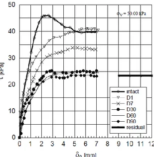
With reference to shear stress, Gullà et al. (2005) show that the stress-displacement curves of intact clays exhibit a much greater shear strength than the shear strength of those weathered. The intact clay shows peak shear strength well defined that decreases with the displacement; by contrast, the weathered clays do not show such decay and the peak shear
2. Literature review on shallow landslide in fine-grained soils
17
strength goes to asymptotic value with increase of displacement, Figure 2.9.
Figure 2.9 Stress-displacement relationships of intact and weathered specimens compared with residual shear strength (Gullà et al., 2006).
The peak shear strength reductions are pronounced in the first month of degradation; subsequently, they could be essentially regarded as constant. The peak shear strengths of the specimens subjected to 30-day, 60- day and 90-day cycles of degradation are similar to each other (Gullà et al., 2008).
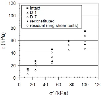
The authors observed that the shear strength envelopes for intact and degraded clay show considerable differences, Figure 2.10. By increasing the number of degradation cycles, the strength envelopes of the weathered specimens are close to those of the reconstituted specimens.
18
Figure 2.10 Strength envelopes of intact and weathered clay compared with reconstituted and residual envelopes.
I
NPUT DATA AND METHODS OF ANALYSIS IN THESCIENTIFIC LITERATURE
Figure 2.11 shows that about 70 % of the papers analysed makes use of mono-disciplinary approaches, and about 30% of multidisciplinary approaches, being the percentage calculated on a total of about 30 papers examined.
2. Literature review on shallow landslide in fine-grained soils
19
With reference to monodisciplinary approaches, several available studies separately analyse hydrological, geological and geomorphological characters as (M. J. Crozier et al. 2005, Antronico et al. 2000, Sorriso Valvo et al. 2004, Guzzetti et al. 2008); others studies essentially focus on geotechnical and numerical aspects as in the case of (Lim et al. 1996, Eigenbrod et al 1999, Claessens et al. 2007, Eden et al. 1969).
The work by Lim et al. (1996) is of great interest given the high number of in situ investigations carried out in an area of 200 m2 where 36 “jet fill” tensiometers were installed to monitor the role of negative pore-water pressures on slope stability conditions, Figure 2.12.
20
Analysing the change in matrix suction under different vegetative condition (canvas over grass, grass and bare slope) or in response to changes in climatic conditions, Figure 2.13, the author highlights some similarities in the characteristics of in situ matrix suction variations under three different surface conditions, Figure 2.14.
Figure 2.13 (a) Generalized soil profile through the instrumented slope; (b) Ground surface condition on the instrumented slope (Lim et al. 1996).
Figure 2.14 In situ matrix suction measurement in the slope with canvas over grass, grass and bare surface (Lim et al., 1996).
Figure 2.14 shows that maximum change in matrix suction often occurs near the ground surface (i.e. at a depth of 0.5m), and the magnitude of the changes generally decreases with depth. The variation in matrix suction due to periodic wetting and drying is most significant in the bare slope section and least significant in the canvas-covered slope. Changes in climate conditions result in variations in the matrix suction profile with depth (in this case, the ground surface is the first to be affected) and time. The variation of the matrix suction profile is less significant under the canvas-covered section than under the grassed-covered and bare
2. Literature review on shallow landslide in fine-grained soils
21
sections of the slope. A perched water table appears to have developed in the instrumented slope at a depth of about 1.5 m below the ground surface during rainy periods.
In situ data acquisition is the starting point in a more complex process aimed at the understanding of the triggering mechanism(s) of shallow landslides in fine-grained soils which must necessarily be investigated by means of geotechnical models. For example, Eigenbrod and Kaluza (1999), with reference to shallow ground movements occurred in Ontario, propose an analysis of slope movements on one of the grassy slopes in the valley, Figure 2.15.
Figure 2.15 Geological section of slope with location of slip surface (Eigenbrod and Kaluza, 1999).
The authors monitored and examined the phenomenon since 1989 with 19 test holes, two test pits, and various field instruments such as slope-indicator casings, electrical piezometers, stand pipes, and thermistors. Once the geotechnical properties of involved soils were known, and after measuring the piezometric pressures in the upper fractured clay zone, the authors performed a back analysis starting from the maximum values usually reached in early summer, i.e. at the same time when ground movements occurred. The authors, using a pore-pressure coefficient ru = 0.5 (water pressure/total overburden pressure), indicated reactivated
22
movements at fully softened strength conditions (c’ = 0, f’= 30°), Figure 2.16.
Figure 2.16 Slope stability analysis. (a) Factor of safety versus angle of friction. (b) Factor of safety versus pore-water pressure coefficient at slip surface (Eigenbrod and Kaluza, 1999).
The monodisciplinary approaches previously summarized usually provide excellent solutions but they do not offer a general framework for the analysis of shallow landslides in fine-grained soils since they investigate only some features of these phenomena and solve specific problems. Generally, this kind of goal can be reached through a multidisciplinary approach which, combining at least two disciplines, can offer a complete solution to the problem by enhancing the potentiality of each discipline.
The majority of multidisciplinary studies analysed in this thesis mix hydrological and geotechnical aspects identifying the critical rainfall by means of a back analysis of the rainfall events occurred, and subsequently modelling the stability conditions of the landslides phenomena.
Other studies combine geological and geomorphological aspects identifying a morpho-evolutional model associated with geotechnical information. For example, Antronico et al. 2001 identify some typical elements of shallow landslides by calculating the morphometric parameters of the slopes affected by such superficial phenomena. The same authors underline the presence of an uncommon ADZ3 weathered material, where surface instabilities occur, which is in contact with an AIZ3 material, Figure 2.17, with intervals of LSZ3 sands levels
From a phenomenological point of view, the surveys carried out in situ by the authors over 10 years of research, coupled with the
photo-2. Literature review on shallow landslide in fine-grained soils
23
documentation available, allowed to the define a typical morpho-evolutive model for complex shallow landslides (10 m long, with a scarp width of about 8 m) localised on open slopes having a slope angle between 38°-40°.
Figure 2.17 Block diagram of soil slip and grain size distributions (Antronico et al., 2001).
Meisina (2006) confirms the influence of weathered thickness on the triggering and the evolution of such phenomena, proposing a methodology for the identification and mapping of weathered clay soils responsible for shallow landslides. Such methodology can also determine geological, geomorphological and geotechnical characteristics of weathered clay soils associated to shallow landslides. The proposed method is based on the integration of intensive field work together with laboratory tests, in order to define areas that may be regarded as homogeneous from the geomorphologic and engineering geological point of view in terms of shallow slope instability, Figure 2.18.
This methodology, useful for studies to be developed at scales between 1:10,000-1:5000, requires a deep knowledge of the lithological and geological characteristics of the area.
24
Figure 2.18 Engineering geological unit map (Meisina, 2006).
The papers previously summarized do not make use of geotechnical models for the back analysis of the phenomena occurred in the test area, although the back analysis is a fundamental step to quantify the failure stage. For this purpose, the work developed by Borga et al. 2002 uses simple models such as the limit-equilibrium model for an infinite slope and manages to provide useful information on the role played by several factors such as root cohesion (Cr), soil cohesion (Cs), slope angle (θ), vertical soil depth (D), the vertical height of the water table within the soil layer (Dw),as confirmed by the formula used to calculate the factor of safety expressed by:
2. Literature review on shallow landslide in fine-grained soils
25
The overall results obtained using eq. (1) are described in Figure 2.19 which illustrates the relative importance of each variable taken into account in slope stability analysis. Figure 2.19 shows that the root strength increases the factor of safety FS if the depth of the soil increases, while soil depth, groundwater–soil depth ratio and tree surcharge will decrease the FS if the slope angle increases.
Figure 2.19 Sensitivity plot for the infinite slope equation (Borga et al., 2002).
Despite the use of a multidisciplinary approach, none of the previous papers provide a general framework for the identification of the predisposing factors and of the triggering causes of shallow landslides. These phenomena can be better investigated by a multi-scale approach that necessarily combines different scales of analysis and, consequently, different disciplines; this approach enhances the potentialities of each single discipline as it has been demonstrated by (Calvello et al. 2012, Cascini et al. 2005a) analyzing shallow landslides in collapsible pyroclastic soils of the Campania region in southern Italy.
26
Lasciare bianca questa pagina solo se (come in questo caso) il capitolo precedente finisce in una pagina dispari. Questo per garantire che ogni nuovo capitolo inizi su una pagina a destra (ovvero dispari).