A SOURCE-TO-SINK HISTORY OF THE SUPRADETACHMENT GEDIZ GRABEN (W TURKEY): FROM EXHUMATION OF THE CENTRAL MENDERES MASSIF THROUGH THE
GEDIZ DETACHMENT FAULT TO SEDIMENTATION IN THE BASIN
A PhD Thesis By Riccardo Asti
Scuola Dottorale in Geologia dell’Ambiente e delle Risorse (SDiGAR) XXVIII Cycle
Department of Sciences Università degli Studi Roma Tre
Rome, Italy
Advisor:
Prof. Claudio Faccenna1 Co-advisors:
Prof. Marco Giovanni Malusà2 Prof. Federico Rossetti1 Prof. Domenico Cosentino1
1) Università degli Studi Roma Tre, Department of Sciences, Rome, Italy
2) University of Milano-Bicocca, Department of Earth and Environmental Sciences, Milan, Italy
2
TABLE OF CONTENTS
CHAPTER 1 - INTRODUCTION ... 5
REFERENCES ... 7
CHAPTER 2 - UNRAVELING THE TECTONO-SEDIMENTARY EVOLUTION OF A SUPRADETACHMENT BASIN BY DETRITAL APATITE FISSION TRACK THERMOCHRONOLOGY – THE GEDIZ GRABEN, MENDERES MASSIF, WESTERN TURKEY ... 10
Abstract ... 10
1. INTRODUCTION ... 11
2. GEOLOGICAL SETTING ... 12
2.2. The Gediz Graben ... 14
3. METHODS ... 15
3.1. Sampling strategy ... 16
3.2. Samples preparation and analysis... 19
4. RESULTS ... 21
4.1. Modern rivers ... 21
4.2. Neogene-to-Quaternary basin fill ... 25
5. DISCUSSION ... 27
5.1. Detrital AFT age evolution of the Neogene-to-Quaternary sedimentary sequence 27 5.2. Information from main river’s tributaries detrital AFT ages and along-strike variations of the cooling pattern of the southern margin of the basin ... 30
5.3. Considerations on apatite fertility and short-term erosion pattern ... 33
5.4. Schematic evolution of the Gediz Graben ... 36
6. CONCLUSION ... 39
REFERENCES ... 40
CHAPTER 3 - MAGMATISM EMPLACEMENT AND CRUSTAL EXTENSION: CONSTRAINING THE ACTIVATION OF DUCTILE SHEARING ALONG THE GEDIZ DETACHMENT, MENDERES MASSIF (WESTERN TURKEY) ... 47
Abstract ... 47
3
2. GEOLOGICAL BACKGROUND ... 49
3. METHODS ... 52
4. RESULTS ... 53
4.1. Structures, textures and petrography ... 53
4.2. Titanite crystallisation ... 56
4.3. Titanite U-Pb geochronology ... 57
5. DISCUSSION ... 59
5.1. Cooling history of the Salihli granodiorite: linking exhumation to extensional shearing ... 60
6. CONCLUDING REMARKS ... 62
REFERENCES ... 63
CHAPTER 4 - TECTONO-STRATIGRAPHIC EVOLUTION OF THE GEDIZ SUPRADETACHMENT BASIN (MENDERES MASSIF, W TURKEY) ... 73
Abstract ... 73
1. INTRODUCTION ... 75
2. GEOLOGICAL SETTING ... 75
3. METHODS ... 79
3.1. Field data collection ... 79
3.2. Sampling strategy and samples preparation for micropaleontological analyses ... 80
4. RESULTS ... 81 4.1. Stratigraphic setting ... 81 4.1.1. Alaşehir Formation ... 81 4.1.2. Ҫaltilik Formation ... 83 4.1.3. Gediz Formation ... 87 4.1.4. Kaletepe Formation ... 88 4.2. Micropaleontological analyses ... 90 4.3. Structural analysis ... 94
4.3.1. Structure of the basin margin in the Salihli area – The Gediz Detachment ... 94
4.3.2. Structure of the basin margin in the Alaşehir area ... 97
4.3.3. High-angle brittle faulting and syn-sedimentary faults ... 98
4
5.1. Insights from micropaleontological data ... 102
5.2. Considerations on the Neogene-to-Quaternary basin fill ... 103
5.3. Considerations on the structural pattern ... 104
5.4. Evolution of Neogene-to-Present extensional process revealed by schematic 2D across-strike reconstruction of the activity of the Gediz Detachment ... 105
5.5. Evolutionary model ... 108
5.6. Implications for the exhumation of the Central Menderes Massif ... 111
6. CONCLUSION ... 112
5
CHAPTER 1 INTRODUCTION
Continental metamorphic core complexes are generally considered the result of large-scale crustal stretching in orogenic belts following the contractional phase; here, mid-crustal metamorphic rocks are exhumed to the surface at the footwall of gently dipping ductile-to-brittle shear zones, commonly referred to as detachment faults (e.g. Coney, 1974, 1980; Crittenden et al., 1980; Davis et al. 1980, 2004; Wernike, 1985; Lister and Davis, 1989; Whitney et al., 2013; Platt et al., 2015). At the footwall of detachment faults it is common the occurrence of pre- or syn-deformational magmatic intrusions (e.g. Lister and Baldwin, 1993; Parsons and Thompson, 1993), whereas at the hanging wall supradetachment sedimentary basins may record major tectonic and exhumation events (e.g. Friedmann & Burbank, 1995). Understanding the dynamic of detachment faulting and the tectonostratigraphic evolution of supradetachment basins can thus give a complete framework of the extensional and exhumation processes that lead to the formation of metamorphic core complexes.
The Menderes Massif of western Turkey constitutes the eastern termination of the Aegean Extensional Province, a portion of the Alpine-Himalayan belt related to the north-dipping Hellenic subduction (e.g. Jolivet and Brun, 2010 and references therein). This region is undergoing ~N-S oriented extension in a back-arc tectonic setting since Eocene times (Dinter and Royden, 1993; Brun and Facenna, 2008; Brun and Sokoutis, 2012); this tectonic regime led to the formation and exhumation of a series of Cenozoic metamorphic core complexes (e.g. Jolivet and Brun, 2010; Ersoy et al., 2014 and references therein), among which the Menderes Massif (e.g. Şengör & Yilmaz, 1981; Şengör et al., 1984; Bozkurt and Park, 1994). The aim of this PhD study is the reconstruction of the whole source-to-sink evolution of the supradetachment Gediz Graben, from the intrusion of the Salihli Granodiorite in the upper crust presently outcropping at its southern margin, to the activation and evolution of the ductile-to-brittle Gediz Detachment Fault, to the tectono-stratigraphic evolution of the basin itself and of its margins. The main purposes are the understanding of the exhumation process of the Central Menderes Massif at the footwall of the detachment (and in general the exhumation pattern), the quantification of the amount of extension accommodated during the
6
extensional process and in general the identification of key chronological constrains to reconstruct the Neogene tectonic history of this portion of the Menderes Massif.
This PhD thesis is built up as a collection of three scientific papers ready to be submitted for publication, presented in the next chapters, that are the result of the work done in the last three years. These complementary papers form a coherent work on the Neogene evolution of the Gediz Graben and of the Gediz Detachment, with relevant implications for the tectonic and exhumation history of the Central Menderes Massif and for the evolution of detachment fault systems in general.
In the first of these papers (Chapter 2: “Unraveling the tectono-sedimentary evolution of a
supradetachment basin by detrital apatite fission track thermochronology – The Gediz Graben, Menderes Massif, Western Turkey”) the results of a detrital apatite fission track
thermochronology study of the Gediz Graben are presented. By integrating detrital apatite fission track ages from modern rivers’ sediments and from the Neogene-to-Quaternary sedimentary fill of the basin, the exhumation history of the northern margin of the Central Menderes Massif, the Neogene-to-Present evolution of the Gediz Graben and the modern erosion pattern of the surrounding bedrock have been reconstructed. This allowed to identify the major bedrock erosion events recorded in the basin sedimentary fill and to reveal that major along-strike variations in the recent cooling and short term erosion pattern exist at the southern margin of the basin; these variations have been attributed to the extremely localized nature of the last exhumation event that occurred in this area.
In the second paper (Chapter 3: “Magmatism emplacement and crustal extension:
constraining the activation of ductile shearing along Gediz Detachment, Menderes Massif (western Turkey)”) the relationship between the intrusion of the Miocene Salihli Granodiorite
and the onset of ductile extensional deformation on the Gediz Detachment has been investigated. Textural analysis and in situ U-Th-Pb titanite dating have been carried out from selected samples collected in the transition from the undeformed to the mylonitized zones of the Salihli granodiorite at the footwall of the Gediz detachment fault. This study highlighted a bimodal distribution of the 206Pb/238U titanite ages that likely recorded the transition from magma crystallization and emplacement to the syn-tectonic, solid-state recrystallization, thus pointing to a major role of the magmatic intrusion in triggering the ductile extensional
7
detachment tectonics. This new dataset, integrated with previously published thermochronological data, allowed to produce a complete reconstruction of the cooling history of the Salihli Granodiorite, since its uppermost Early Miocene intrusion at shallow crustal depths until its Quaternary exhumation at the surface.
In the third and last paper (Chapter 4: “Tectono-stratigraphic evolution of the Gediz
supradetachment basin (Menderes Massif, W Turkey)”) field data collected during the
1:25.000 scale geological mapping of the study area are presented together with new micropaleontological constrains. This work allowed to identify major differences in both the structural and stratigraphic patterns between the western and eastern sector of the study area. Moreover, new paleontological data allowed to refine the poorly constrained age of formation of the basin and revealed the presence of a Late Miocene short-lived marine episode in the stratigraphic record. At the end of this chapter an evolutionary model for the Gediz Graben is proposed to reconcile all the evidences presented in this thesis. This reconstruction show that this supradetachment basin displayed many different structural styles during its extensional evolution, from ramp-basin, to half-graben, to symmetric graben. In general, the aim of this work is to quantify the amount of extension accommodated since the formation of the basin to exhume the ductile-to-brittle Gediz Detachment and its footwall and to unravel the contribution of the different tectonic structures/phases to the exhumation of the Central Menderes Massif.
REFERENCES
Bozkurt, E., Park, G.R., 1994. Southern Menderes massif: an incipient metamorphic core
complex in western Anatolia, Turkey. Journal of the Geological Society of London, 151, 213–
216.
Brun, J.P., Faccenna, C., 2008. Exhumation of high-pressure rocks driven by slab rollback. Earth Planet. Sci. Lett., 272, 1–7.
Brun, J.-P., Sokoutis, D., 2012. 45 m.y. of Aegean crust and mantle flow driven by trench
8
Coney, P.J., 1974. Structural analysis of the Snake Range “décollement,” east-central
Nevada. Geological Society of America Bulletin, 88, 1237–1250.
Coney, P.J., 1980. Cordilleran metamorphic core complexes: An overview, in Crittenden, M.D., Coney, P.J., and Davis , G.H., eds., Cordilleran Metamorphic Core Complexes: Geological Society of America Memoir, 153, 7–34.
Crittenden, M.D., Jr., Coney, P.J., Davis, G.H., eds., 1980. Cordilleran Metamorphic Core
Complexes. Geological Society of America Memoir, 153, 490 p.
Davis, G.A., Anderson, J.L., Frost, E.G., and Shackelford, T.J., 1980. Mylonitization and
detachment faulting in the Whipple-Bucksin-Rawhide Mountains terrane, southeastern California and western Arizona. in Crittenden, M.D., Coney, P.J., and Davis, G.H., eds.,
Cordilleran Metamorphic Core Complexes: Geological Society of America Memoir, 153, 9-129.
Davis G. H., Constenius K. N., Dickinson W. R., Rodríguez E. P., Cox L. J., 2004. Fault and
fault-rock characteristics associated with Cenozoic extension and core-complex evolution in the Catalina–Rincon region, southeastern Arizona. Geological Society of America Bulletin,
116, 128-141.
Dinter, D.A., Royden, L., 1993. Late Cenozoic extension in northeastern Greece: Strymon
Valley detachment system and Rhodope metamorphic core complex. Geology, 21, 45–48.
Ersoy E.Y., Çemen İ., Helvacı C., Billor Z., 2014 - Tectono-stratigraphy of the Neogene
basins in Western Turkey: Implications for tectonic evolution of the Aegean Extended Region.
Tectonophysics, 635, 33–58.
Friedmann S. J. & Burbank D. W., 1995. Rift basins and supradetachment basins:
intracontinental extensional end-members. Basin Research, 7, 109-127.
Jolivet, L., Brun, J.P., 2010. Cenozoic geodynamic evolution of the Aegean. International Journal of Earth Sciences, 99, 109–138.
Lister G. S. & Baldwin S. L., 1993. Plutonism and the origin of metamorphic core complexes. Geology, 21, 607-610.
9
Lister, G.S., and Davis, G.A., 1989. The origin of metamorphic core complexes and
detachment faults formed during Tertiary continental extension in the northern Colorado River region, USA. Journal of Structural Geology, 11, 65–94, doi:10.1016/0191-8141(89)90036-9.
Parsons T. & Thompson G. A., 1993. Does magmatism influence low-angle normal faults? Geology, 21, 247-250
Platt et al., 2015
Şengör A. M. C. & Yilmaz Y., 1981. Tethyan evolution of Turkey: a plate tectonic approach. Tectonophysics, 75, 181–241.
Sengör, A.M.C., Satir, M., Akkök, R., 1984. Timing of the tectonic events in the Menderes
massif, western Turkey: implications for tectonic evolution and evidence for Pan- African basement in Turkey. Tectonics, 3, 693–707.
Wernike, B., 1985. Uniform-sense normal simple shear of the continental lithosphere. Canadian Journal of Earth Sciences, 22(1), 108-125.
Whitney D. L., Teyssier C., Rey P. & Buck W. R., 2013: Continental and oceanic core
10
CHAPTER 2
UNRAVELING THE TECTONO-SEDIMENTARY EVOLUTION OF A SUPRADETACHMENT BASIN BY DETRITAL APATITE FISSION TRACK THERMOCHRONOLOGY – THE GEDIZ
GRABEN, MENDERES MASSIF, WESTERN TURKEY
Riccardo Asti1, Marco Giovanni Malusà2 and Claudio Faccenna1
1) Università degli Studi Roma Tre, Department of Sciences, Rome, Italy
2) University of Milano-Bicocca, Department of Earth and Environmental Sciences, Milan, Italy
Abstract: The Menderes Massif is an outstanding example of Tertiary metamorphic core complex, exhumed in the upper Oligocene – Miocene time, during the deposition of a series of E-W trending basins. Several studies address to the exhumation history of the massif, but the depositional history of this basins is still poorly defined. The aim of this study is to reconstruct the source-to-sink evolution of the Gediz Graben, defining the exhumation/cooling pattern of the Central Menderes Massif at the footwall of the Gediz Detachment Fault and reconstructing the sedimentary evolution of the basin. We used low-temperature detrital thermochronology to unravel the sedimentary history of the basin and the erosion pattern of the study area on short-term and long-term timescales. We integrated fission track dating of detrital apatite from the modern Alaşehir/Gediz river and from some of its tributaries with a careful assessment of hydraulic sorting effects and mineral fertility in the source rocks. We additionally performed detrital apatite fission track analyses on the ancient sedimentary succession to better constrain the age of the Neogene sedimentary fill of the graben. We found that a Late Miocene major event of bedrock exhumation localized at the northern margin of the Central Menderes Massif have been recorded in the basin, following the Upper Oligocene/Lower Miocene main cooling event that involved the whole Menderes Massif. A second and more recent cooling event involved only the western portion of the southern margin of the basin, leading the Gediz Detachment and the Salihli Granodiorite to the surface in very recent times in the Bozdağ area (Early Pleistocene). The modern short term erosion
11
pattern closely reflects this event, showing higher erosion rates in the exposure area of the Gediz Detachment than in the rest of the investigated region.
1. INTRODUCTION
The Aegean region is an outstanding example of an area where a phase of intense crustal extension followed an orogenic phase of shortening and thickening of the continental crust (e.g. Jolivet & Faccenna, 2000); here, late to post-orogenic extension is ongoing since Eocene time (e.g. Brun & Sokoutis, 2007). In regions of intense post-orogenic extension, tectonics can commonly lead to exhumation of upper-to-middle crustal rocks, usually by extensional ductile-to-brittle detachment faults that eventually put in contact deeply buried mylonitic metamorphic rocks at the footwall with unmetamorphosed upper crustal rocks at the hanging wall (e.g. Gibbs, 1984; Lister & Davis, 1989). Nevertheless, it is always important to take into account the fact that exhumation results from the combination of tectonic processes and erosion at the surface (e.g. England & Molnar, 1990). In highly extended continental terrains, supradetachment basins with high sedimentation rates associated to the main tectonic structures may record phases of tectonic activity and erosion, giving important constrains on the exhumation history of the region (e.g. Friedmann & Burbank, 1995).
Along-strike variations of the cooling pattern are seldom taken into account; their identification, together with careful field analysis of structures, is fundamental to discriminate between local and regional exhumation events, thus avoiding misinterpretation in tectonic reconstructions. This kind of variation might also be reflected in the erosion pattern that onset after exhumation.
Despite many study addressed to the sedimentary fill of the basin, the chronology of sedimentation in the Gediz Graben is still poorly defined; detrital apatite fission-track analysis can be then an invaluable tool to define the maximum age of sedimentary deposits where constrains from other sources (like paleontology, or datable volcanic deposits) are lacking (e.g. Baldwin et al., 1986; Gallagher et al., 1998).
In this study, the analysis of detrital apatite fission-track from both modern river sediments and from the Neogene-to-Quaternary sedimentary fill of the Gediz Graben allowed us to
12
reconstruct the exhumation and sedimentary history of the study area since the formation of the basin until present times, drawing a geologic evolution in which the succession of the main sedimentary and exhumation events is unraveled and the contribution of the different structures (among which the Gediz Detachment Fault) is determined.
2. GEOLOGICAL SETTING 2.1. The Menderes Massif
The Menderes Massif is exposed along the Western Turkey sector of the Alpine-Himalayan belt which has experienced during the Cenozoic an orogenic phase and post-orogenic collapse (e.g. Şengör et al., 1984; Şengör, 1987; Gessner et al., 2013). It is built up of continental fragments with African affinity accreted along the southern margin of Laurasia and separated by major suture zones (Şengör et al., 1984). The Menderes Massif is located in the southernmost among these continental blocks, namely the Tauride-Anatolide Platform, according to Şengör & Yilmaz (1981). This block is separated from the Sakarya zone to the North by the Izmir-Ankara Suture Zone.
Rocks outcropping in the Menderes Massif recorded a complex tectono-metamorphic history, preserving traces of Pan-African, Variscan and Alpine tectono-metamorphic events (e.g. Ring et al., 1999; Lips et al., 2001; Oberhänsli et al., 2010 and references therein). The Alpine nappe stack of the Menderes Massif represents the lowermost tectonic unit of the Anatolide Belt (e.g. Ring et al., 1999, 2001; Gessner et al., 2013 and references therein), and is composed of 4 nappes: 1) the Selimiye Nappe is the structurally uppermost unit and is composed of low-grade metabasites, metapelites and marble with protolith ages spanning from Precambrian to Devonian/Carboniferous times (e.g. Ring at al., 1999, 2001 and references therein; Régnier et al., 2003); 2) the underlying Çine Nappe is composed mainly of orthogneiss and undeformed metagranite with intrusion age of the protolith around 530-560 Ma (e.g. Zlatkin et al., 2013 and references therein) and minor pelitic gneiss, eclogite and amphibolite (e.g. Ring et al., 1999, 2001); 3) the Bozdağ Nappe occurs structurally below and is mainly composed of metapelite with minor lens of marble, amphibolite and eclogite (Ring et al., 1999, 2001); the Bayındır Nappe is the lowermost tectonic unit and consists of Alpine
13
greenschist facies phyllite, quartzite and marble (e.g. Lips et al., 2001; Ring et al., 1999, 2001).
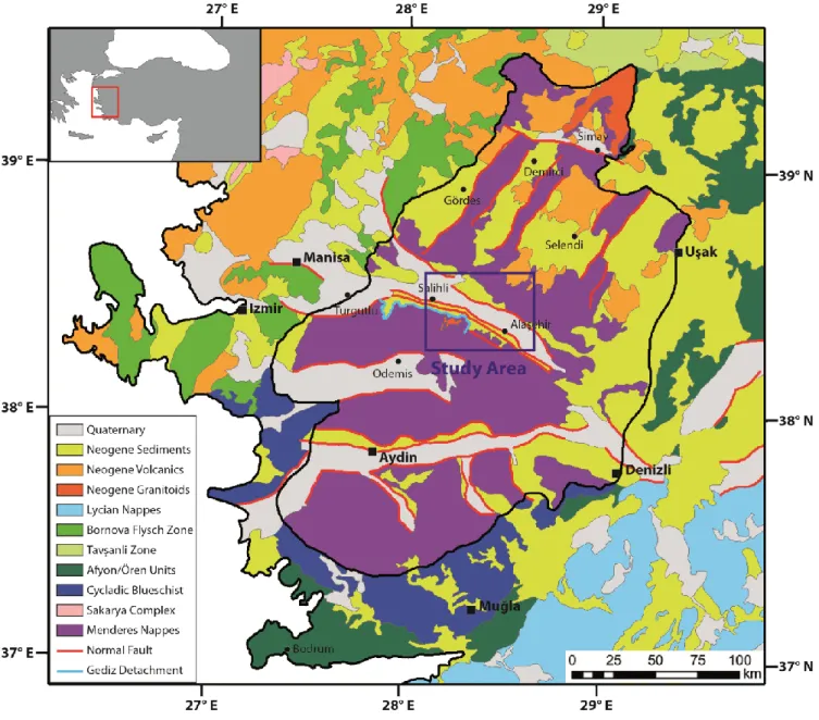
Figure 1: Schematic tectonic map of SW Turkey. The black line delimitates the Menderes Massif; the blue box
show the location of the study area represented in Fig. 2.
The NNE-SSW directed extensional phase that affects the Anatolide Belt since the latest Oligocene and related retreat of the Aegean subduction system (e.g. Şengör, 1987; Seyitoğlu & Scott, 1996a; Thomson & Ring, 2006; Jolivet & Brun, 2010) led to the Miocene formation of two major E-W trending grabens (Büyük Menderes and Gediz graben) that divided the Menderes Massif in three sub-massifs (i.e. Northern, Central and Southern Menderes Massif).
14
During this phase the gently dipping (~20°) ductile-to-brittle Gediz Detachment Shear Zone was formed; it separates mylonitic gneiss deformed under greenschist conditions at its footwall from unmetamorphosed Neogene sediments of the Gediz Graben at its hanging wall (e.g. Hetzel et al., 1995). The mylonitic foliation of the detachment dips gently to the NNE and shows a well-developed stretching lineation oriented ~N30 and kinematic indicators always reporting a top-to-the-NNE sense of shear (e.g. Işik et al., 2003).
Two syn-extensional intrusive bodies outcrop at the footwall of the Gediz Detachment, namely the Salihli and Turgutlu granodiorite; the intrusion age of these plutons has been suggested to be early-middle Miocene, around 15-16 Ma (Glodny & Hetzel., 2007).
At the hanging wall of the Gediz Detachment the Neogene-to-present deposits of the Gediz Graben lay on top of the detachment’s surface in tectonic contact, with strata tilted to the SSW cut by high-angle normal faults that root on the detachment.
Existing thermochronological data for the Menderes Massif (Gessner et al., 2001, 2013; Ring et al., 2003; Thomson & Ring, 2006; Buscher et al., 2013) highlighted two major episodes of cooling during the Cenozoic, a first one during late Oligocene – early Miocene and a second one from late Miocene to Quaternary, with the latter involving only the Central Menderes Massif and showing a clear rejuvenation trend of the cooling ages from S to N in the Gediz Detachment’s area.
2.2. The Gediz Graben
The formation of the Gediz Graben is related to the activity of the Gediz Detachment and the other major normal faults bounding the northern margin of the Central Menderes Massif (e.g. Ҫiftçi & Bozkurt, 2009; Öner & Dilek, 2011), but clear age constrains for the beginning of the sedimentation and for the main sedimentary events are lacking. The basin’s formation and the sedimentation of the lower half of the fill have been inferred to be early-middle Miocene in age, on the base of palynological data (e.g. Seyitoğlu and Scott, 1992; Ediger et al., 1996). Ҫiftçi & Bozkurt (2009) suggested that the basin developed as an half-graben with an active southern margin during Miocene and changed its geometry during post-Miocene with the activation of the northern margin.
15
In the Gediz Graben, major differences in the cooling pattern exist between the northern and southern margin of the basin, the former being exhumed in Late Oligocene – Early Miocene times and the latter between Late Miocene and Early Quaternary (Gessner et al., 2001, 2013; Ring et al., 2003; Thomson & Ring, 2006, Buscher et al., 2013).
Many studies in the last two decades have addressed the sedimentary evolution of the Gediz Graben, but most of these used different names and subdivisions for the lithostratigraphic units of the basin fill (e.g. Iztan & Yazman, 1991; Cohen et al., 1995; Emre, 1996; Koçyiğit et al., 1999; Sarica, 2000; Yilmaz et al., 2000; Seyitoğlu et al., 2002; Purvis & Robertson, 2005; Ҫiftçi & Bozkurt, 2009), thus making difficult to unravel the stratigraphy of this area and generating controversies on the age of different formations. In this study we use the nomenclature proposed by Ҫiftçi & Bozkurt (2009), with some modifications due to field observations and differences in the stratigraphic sequence in outcrop between western and the eastern sectors of the study area, who divided the sedimentary sequence outcropping at the southern margin of the basin in 4 different lithostratigraphic formations: the oldest one is represented by the Alaşehir Fm., which is made of grey-to-brownish continental conglomerates and sandstones (Evrenli Mbr.) heteropic with lacustrine shales and siltstones (Zeytinçayi Mbr.); above this, are the concordant continental red sandstones and conglomerates of the Ҫaltilik Fm., that are characterized in their lower part by a few-tens of meters thick limestone interval; the above Gediz Fm. is represented by yellowish continental sandstones and conglomerates with an overall coarsening-upward trend; the uppermost unit is the discordant Plio-Quaternary Kaletepe Fm., generally made of brown continental conglomerates and sandstones. On top of this Neogene-to-Quaternary sedimentary sequence are the Quaternary alluvial deposits of the modern graben.
For what concerns the distribution in outcrop of the different formations of the sedimentary sequence, major differences exist between the eastern (Alaşehir area) and the western (Salihli area) sector of the study area; the older deposits (i.e. the Alaşehir Fm. and the lower part of the Ҫaltilik Fm.) outcrop only in the former area, whereas in the latter the oldest outcropping deposits are represented by the middle part of the Ҫaltilik Fm.
16
Apatite fission-track dating method relies on the damages produced in the crystal lattice by fission decay of radioactive elements and that are preserved in the mineral below the closure temperature of ~110/120°C, providing useful information on cooling and exhumation through the upper 3-4 Km of the crust (Gallagher et al., 1998).
Apatite fission-track analysis from detrital samples represents a powerful tool to quantify the sedimentary budget from main river’s tributaries draining rocks that experienced contrasting cooling history (e.g. Resentini & Malusà, 2012). The determination of apatite budget from each source area in this kind of study is a key issue, because slowly eroding apatite-rich rocks can provide comparable amounts of apatite of apatite-poor rocks eroding fast, thus representing a major and unneglectable source of bias (Resentini & Malusà, 2012; Malusà et al., 2015). In general, by integrating detrital apatite fission track analysis from modern sediments and from the ancient sedimentary fill of a basin it is possible to build a solid dataset to unravel the erosional/sedimentary history allowing to:
- constrain the maximum age of ancient sedimentary deposits by dating the exhumation of their source rocks, when other constrains are lacking;
- estimate average long-term exhumation rates of the source areas of modern sediments by calculating their age-peaks;
- reconstruct the modern short-term erosion pattern by evaluating the relative erosion rates of the different source areas alimenting the main river’s sediment load.
- reconstruct the ancient short-term erosion patterns by identifying major exhumation events recorded in the ancient basin sedimentary fill;
3.1. Sampling strategy
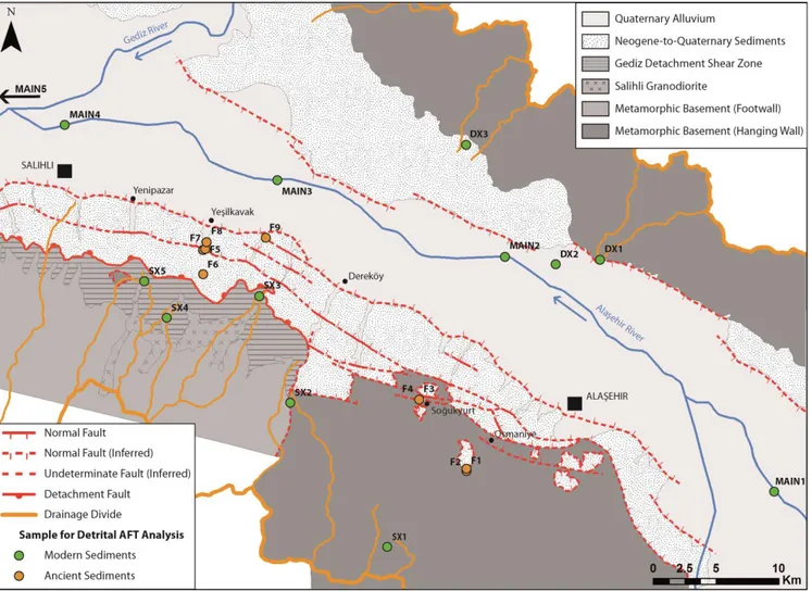
In order to reconstruct the modern erosion pattern of the study area we use the method proposed by Resentini & Malusà (2012). We collected 5 samples of sorted bedload sediment along the trunk of Alaşehir /Gediz river (MAIN1-4 inside the study area from Sarigöl to Salihli in the Alaşehir river and MAIN5 far away in the direction of the river flow after the confluence of the Alaşehir river in the Gediz river) for apatite fission-track dating (Fig. 2). To identify the AFT age signal of the source areas and to determine their apatite fertility, we also collected 5 bedload samples from some of the left tributaries (SX1-5; draining the southern margin of the basin) and 3 from some of the right tributaries (DX1-3; draining the northern margin of the
17
basin); these latter 8 samples were taken in catchments draining only the bedrock of the basin, avoiding influences in the detrital signal and in fertility determination of sediments provided by the Neogene-to-Quaternary basin fill (Fig. 2). Samples SX3-5 were collected in catchments draining the Salihli granodiorite, the mylonitic shear zone of the Gediz Detachment and its footwall (Bayındır nappe), while samples SX1-2 were collected in catchments draining mainly rocks at the hanging-wall of the detachment related to the Çine nappe of the Menderes metamorphic basement. Samples DX1-3 were collected in catchments draining rock related to the Çine and the Selimiye nappe.
Figure 2: Simplified geologic map of the study area with location of the samples for detrital apatite fission track
analysis.
For this study we took samples from strata close to the southern edge of the basin, in order to avoid possible problems with thermal resetting of AFT ages that could be expected in a more central and deeply buried portion of the graben (Garver et al., 1999).
18
In diagenesized sedimentary succession the abundance of any mineral species is not only function of mineral fertility and hydraulic sorting, but also of the stability of minerals to diagenetic dissolution (e.g. Morton, 1985); moreover, disaggregation processes during sample preparation might alter the original grain-size signature of sediments. All this makes impossible the determination of original mineral fertility of the source rocks from ancient sediments (Malusà et al., 2015).
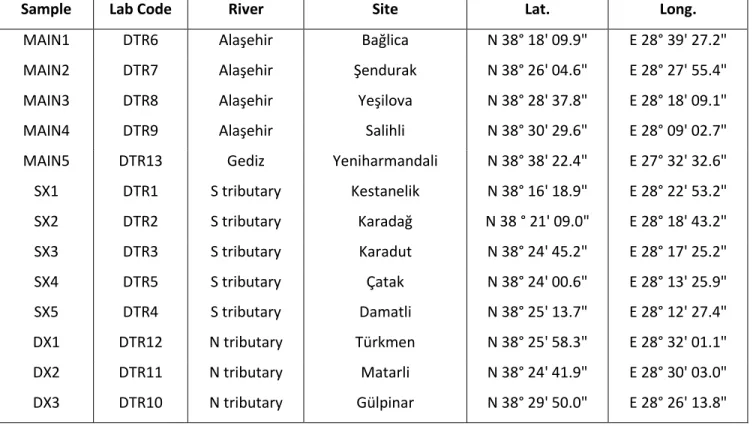
Sample Lab Code River Site Lat. Long.
MAIN1 DTR6 Alaşehir Bağlica N 38° 18' 09.9" E 28° 39' 27.2" MAIN2 DTR7 Alaşehir Şendurak N 38° 26' 04.6" E 28° 27' 55.4" MAIN3 DTR8 Alaşehir Yeşilova N 38° 28' 37.8" E 28° 18' 09.1" MAIN4 DTR9 Alaşehir Salihli N 38° 30' 29.6" E 28° 09' 02.7" MAIN5 DTR13 Gediz Yeniharmandali N 38° 38' 22.4" E 27° 32' 32.6" SX1 DTR1 S tributary Kestanelik N 38° 16' 18.9" E 28° 22' 53.2" SX2 DTR2 S tributary Karadağ N 38 ° 21' 09.0" E 28° 18' 43.2" SX3 DTR3 S tributary Karadut N 38° 24' 45.2" E 28° 17' 25.2" SX4 DTR5 S tributary Ҫatak N 38° 24' 00.6" E 28° 13' 25.9" SX5 DTR4 S tributary Damatli N 38° 25' 13.7" E 28° 12' 27.4" DX1 DTR12 N tributary Türkmen N 38° 25' 58.3" E 28° 32' 01.1" DX2 DTR11 N tributary Matarli N 38° 24' 41.9" E 28° 30' 03.0" DX3 DTR10 N tributary Gülpinar N 38° 29' 50.0" E 28° 26' 13.8"
Table 1: Location of samples from the modern Alaşehir /Gediz river and its tributaries.
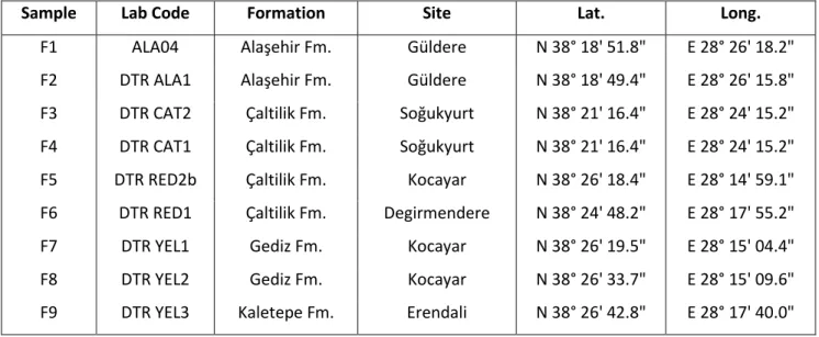
We sampled for detrital AFT analysis the Neogene-to-Quaternary basin fill (Fig. 2 and 7) in order to reconstruct the long-term exhumation history of the area and to find constrains on the maximum age of the different deposits. We took 9 samples from the whole sedimentary succession: 2 samples from the oldest Alaşehir Fm. (Zeytinçayi Mbr., F1-2), 4 samples from the Ҫaltilik Fm. (F3-4 from the lower part with limestone intercalations and F5-6 from the upper part), 2 from the Gediz Fm. (F7-8) and 1 from the Kaletepe Fm. (F9).
19
Sample Lab Code Formation Site Lat. Long.
F1 ALA04 Alaşehir Fm. Güldere N 38° 18' 51.8" E 28° 26' 18.2" F2 DTR ALA1 Alaşehir Fm. Güldere N 38° 18' 49.4" E 28° 26' 15.8" F3 DTR CAT2 Çaltilik Fm. Soğukyurt N 38° 21' 16.4" E 28° 24' 15.2" F4 DTR CAT1 Çaltilik Fm. Soğukyurt N 38° 21' 16.4" E 28° 24' 15.2" F5 DTR RED2b Çaltilik Fm. Kocayar N 38° 26' 18.4" E 28° 14' 59.1" F6 DTR RED1 Çaltilik Fm. Degirmendere N 38° 24' 48.2" E 28° 17' 55.2" F7 DTR YEL1 Gediz Fm. Kocayar N 38° 26' 19.5" E 28° 15' 04.4" F8 DTR YEL2 Gediz Fm. Kocayar N 38° 26' 33.7" E 28° 15' 09.6" F9 DTR YEL3 Kaletepe Fm. Erendali N 38° 26' 42.8" E 28° 17' 40.0"
Table 2: Location of samples from the Neogene-to-Quaternary basin fill of the Gediz Graben. 3.2. Samples preparation and analysis
For all samples from modern catchments, in order to recover the highest amount of apatite grains, we used MinSORTING (Resentini et al., 2013) to model the mineral distribution and sorting in different grain-size windows, defining in this way the grain-size classes with the highest probability to retrieve apatite grains.
To determine apatite fertility in the source areas while separating apatite grains from the bulk sediment we applied to the samples collected in the main river’s tributaries (SX1-5 and DX1-3) the procedure described in Malusà et al. (2015) that allows to determine the apatite concentration in the bulk sediment and to determine if it reflects mineral concentration in the source rocks (Fig. 3).
In samples coming from the Alaşehir /Gediz river (MAIN1-5) and from the Neogene-to-Quaternary basin fill apatite grains were separated from the bulk sediment using standard techniques: 1) pre-concentration of the denser component by GEMINI shaking table processing separately different grain-size classes to minimize the effect of grain-size during hydrodynamic sorting (Malusà et al., 2013); 2) centrifugation of the heavier part in sodium polytungstate with density δ = 2.90 kg/dm3; 3) refinement of the fraction denser than 2.90 kg/dm3 by using a Frantz magnetic separator to remove the magnetic minerals; 4) dense-liquid processing of the dense diamagnetic fraction in diiodomethane (δ = 3.32 kg/dm3).
20 Figure 3: Flowchart for the determination of mineral fertility in bedrock from detrital samples (Malusà et al.,
2015; modified).
All the samples were prepared for nuclear irradiation following the External Detector Zeta (ζ) Calibration Method (Hurford, 1990) and were then irradiated in the TRIGA-II nuclear reactor at
21
Oregon State University (USA). Fission-track counting was carried on in the Laboratory of Milano Bicocca University (Italy) with an Olympus microscope (1250X magnification) equipped with FT-Stage software (Dumitru, 1993). For each counted grain, we documented several features, such as size, shape, the presence of defects and fluid inclusions (in clusters or in plans), and we investigated their potential relationship with fission-track age by using Radial Plotter (Vermeesch, 2009). Grain age was determined by using Trackkey software (Dunkl, 2002), while decomposition of grain-age distribution was carried out with BinomFit software (Brandon, 2002).
4. RESULTS
4.1. Modern rivers
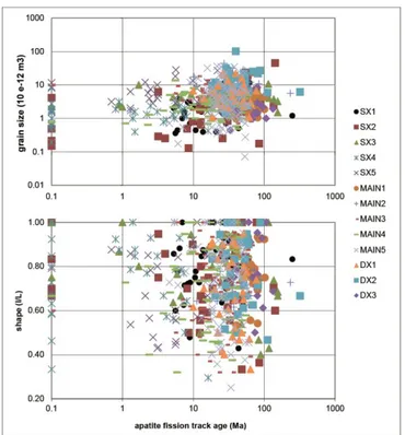
No apparent relationship have been found between grain-age and grain-size and between grain-age and grain-shape in all the samples analyzed (Fig. 4), showing that grain age distributions are not vulnerable to hydraulic sorting effects. Moreover, grain density of the detrital samples from tributaries of the main river (Fig. 5) show values consistent with those expected for deposits with geologically analog source areas, thus suggesting that selective entrainment did not affect their composition and allowing their use to infer the composition of the parent bedrock (Malusà et al., 2015).
22 Figure 4: Diagrams showing the relationship between AFT grain-ages and grain size (top) and between AFT
grain-ages and grain shape (bottom) in the detrital samples collected in the modern rivers. No apparent correlation raised in the correlation between these parameters, showing that the grain-age distributions are not
vulnerable to hydraulic sorting effects.
Figure 5: Dense Mineral Concentration (left) and Grain Density values (right) in samples from the northern (DX)
and southern (SX) tributaries of the main river. Dense Mineral Concentration is always <10% and Grain Density is always <2.70 Kg/dm3: these values show that the analyzed samples are not affected by anomalous
23
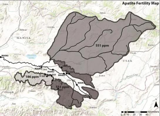
By measuring apatite abundance in processed sediments form tributaries draining the basin’s margin (samples SX1-5 and DX1-3), we found that mean apatite fertility in the outcropping area of the Salihli granodiorite and of the milonitized shear zone of the Gediz Detachment and its footwall (186 ppm) is three times less than the mean fertility of the rest of the source area (551 ppm) (Fig. 6).
Figure 6: Apatite fertility map of the study area. Apatite fertility is expressed in ppm.
Apatite size distribution Apatite
Drainage Area Textural parametrs selected window relative amount dense mineral grain density coarser in selected window finer Fertility
Sample River Site mean
size sorting skewness
> 63 m (km2) (phi) (phi) (phi) (m) (%) (%) (kg/dm3) (%) (%) (%) (ppm)
SX1 Kestanelik Kestanelik 7 2.63 1.26 -0.06 63-500 61.47 1.3 2.59 7.3 78.5 14.2 312.0 SX2 Ozan Karadağ 56 2.40 1.27 -0.05 63-500 55.55 1.8 2.61 10.2 78.9 11 734.0 SX3 Dariyeri Karadut 21 1.70 0.98 0.19 125-500 28.97 1.4 2.62 2.2 70.7 16.7 179.0 SX4 Kisik Ҫatak 17 2.50 1.20 -0.14 63-500 56.56 0.6 2.50 6.6 80.7 11.6 259.0 SX5 Karanohut Damatli 28 1.90 1.14 0.04 125-500 41.66 0.8 2.63 15.9 63.2 20.9 120.0 DX1 - Türkmen 31 2.57 1.24 -0.11 63-500 59.34 4.5 2.60 7.6 79.2 13.1 563.0 DX2 - Matarli 29 1.83 0.85 -0.08 125-500 40.59 5.0 2.69 10.2 77.5 12.2 569.0 DX3 Sarikaya Gülpinar 22 2.00 1.42 -0.11 63-500 49.79 9.1 2.64 19.5 72.4 8.1 577.0
24
In Fig. 9 we reported the results of grain-age distribution of samples from modern rivers, represented in radial plots, with their relative position with respect to the drainage network, showing the confluences of the sampled tributaries in the Alaşehir /Gediz river in order to highlight the influence of their age-signal along the trunk of the main river. All the results for detrital AFT from modern rivers are listed in Table 4.
Sample Age Error % Age Error % Age Error %
1st population 2nd population 3rd population
SX1 9.3 +3.3/-2.4 44.5 25.5 +9.1/-6.7 47.6 47.6 +23.5/-15.7 7.9 SX2 6.4 +2.2/-1.6 44.5 40.8 +7.3/-6.2 55.5 - - - SX3 3.8 +2.4/-1.5 31.4 32.2 +13.9/-9.7 42.4 110.4 +56.3/-37.4 26.2 SX4 0.5 +1/-0.3 61 4.8 +4.1/-2.2 39 - - - SX5 2.4 +0.6/-0.5 69.8 16.7 +3.6/-3 30.2 - - - DX1 26.8 +10/-7.3 62.6 44.1 +23.7/-15.4 37.4 - - - DX2 35.7 +6.8/-5.7 82.8 80.8 +27.5/-20.6 17.2 - - - DX3 68.9 ± 11.7 100 - - - - MAIN1 55.2 ± 5.4 100 - - - - MAIN2 33 +8.1/-6.5 83.2 74.9 +31.6/-22.3 16.8 - - - MAIN3 14.3 +5.4/-3.9 20.9 32.2 +5.9/-5 79.1 - - - MAIN4 11.6 +3.4/-2.7 35.4 37.5 +7.1/-6 64.6 - - - MAIN5 6.6 +5.7/-3 4.6 26.1 +5.7/-4.7 70.5 48.8 +19.3/-13.8 24.9
25 Table 4: (on the previous page) Apatite grain-age populations of samples from the modern Alaşehir /Gediz river
(MAIN1-5) and its soutern (SX1-5) and northern (DX1-3) tributaries; age and error are expressed in Ma.
In most of the cases, decomposition of grain-are distribution yielded more than one distinct population. Samples from catchments draining the southern margin of the basin yielded much younger age peaks (less tha 9.3 Ma for their younger peaks) with respect to those found in catchments draining the northern margin (more than 26.8 Ma for their younger peaks), confirming that the latter have not been exhumed by the same structures responsible for the exhumation in the former sector. We also noticed that variations in the younger age peak occur along the strike of the structures bounding the southern margin (Fig. 10), with the westernmost samples yielding ages younger than 5 Ma (light-grey boxes in Fig. 9) and the easternmost ones yielding ages in the range between 6 and 10 Ma (dark-grey boxes of the southern tributaries in Fig. 9).
Samples SX3-5 yielded the youngest age peaks of the whole study area, while samples SX1-2 provided slightly older ages for the youngest age peak. Samples DX1-3, from catchments draining the northern margin, yielded older ages for their youngest age peaks. All these ages are consistent with bedrock low-T thermochronology ages from northern and southern margin of the basin. Samples MAIN1-5, collected in the Alaşehir /Gediz river, show a rejuvenation of the younger age peak in the direction of the river flow (see radial plots in the central column in Fig. 9).
For what concerns detrital-apatite flux in the main Alaşehir /Gediz river, on sample MAIN3 the contribution from the Gediz Detachment and its footwall (i.e. apatite grains with grain-age >5 Ma) is 2%, for sample MAIN4 it increases to 14% and in sample MAIN5 it decreases again to 3%. Our dataset does not allow to discriminate between the contribution to the apatite flux in the main river from the norther margin of the Gediz Graben and from the eastern portion of the southern margin (Alaşehir area), because of their similar age signal. Furthermore, it is not possible to distinguish the contribution to the main river’s apatite flux of the exposed Neogene-to-Quaternary deposits from that of the metamorphic bedrock at the hanging wall of the Gediz Detachment, because these are characterized by similar AFT ages (see below).
26
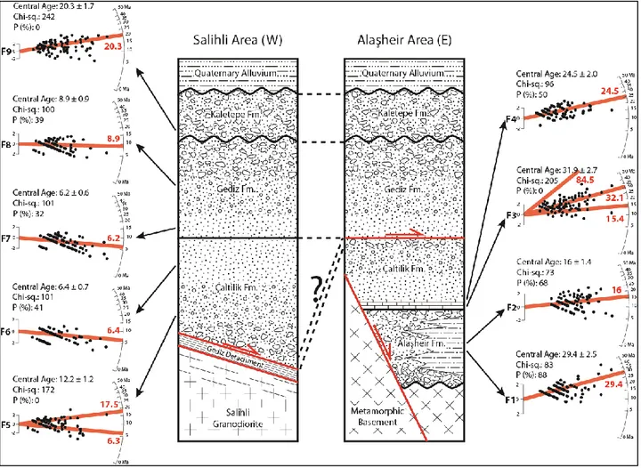
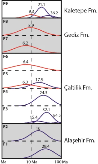
Results for detrital AFT from the Neogene-to-Quaternary sedimentary sequence are listed in Table 5. In Fig. 7 are reported the results of grain-age distribution of samples from ancient sediments of the Gediz Graben sedimentary fill, represented in radial plots, with their position with respect to the Neogene-to-Quaternary stratigraphy of the basin. In the lower part of the stratigraphic sequence, in samples from the Alaşehir Fm. (F1-2) and the lower part of the Ҫaltilik Fm. (F3-4), all the age-peaks obtained after decomposition of grain-age distribution are characterized by ages older than Middle Miocene. Starting from the upper part of the Ҫaltilik Fm. until the youngest deposits of the Kaletepe Fm. (samples F5-9), a younger age-peak is obtained in all the samples, with a Late Miocene age.
Figure 7: Stratigraphy of the Gediz Graben and radial plots reporting apatite fission track grain-age distribution
for detrital samples from the Neogene-to-Quaternary sedimentary sequence (F1-9), with relative stratigraphic position indicated by black arrows. Light-red lines in the radial plots show age peaks (with relative value in red expressed in Ma) for the different populations retrieved after grain-age deconvolution with BinomFit software
27
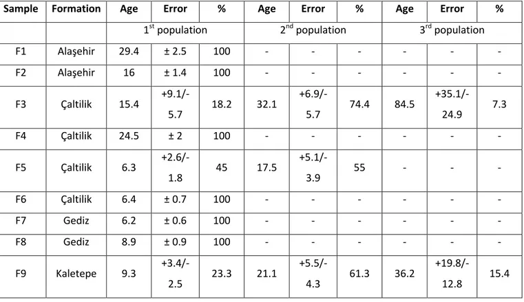
Sample Formation Age Error % Age Error % Age Error %
1st population 2nd population 3rd population
F1 Alaşehir 29.4 ± 2.5 100 - - - - F2 Alaşehir 16 ± 1.4 100 - - - - F3 Ҫaltilik 15.4 +9.1/-5.7 18.2 32.1 +6.9/-5.7 74.4 84.5 +35.1/-24.9 7.3 F4 Ҫaltilik 24.5 ± 2 100 - - - - F5 Ҫaltilik 6.3 +2.6/-1.8 45 17.5 +5.1/-3.9 55 - - - F6 Ҫaltilik 6.4 ± 0.7 100 - - - - F7 Gediz 6.2 ± 0.6 100 - - - - F8 Gediz 8.9 ± 0.9 100 - - - - F9 Kaletepe 9.3 +3.4/-2.5 23.3 21.1 +5.5/-4.3 61.3 36.2 +19.8/-12.8 15.4
Table 5: Apatite grain-age populations of samples from the Neogene-to-Quaternary sedimentary succession of
the Gediz Graben; age and error are expressed in Ma.
5. DISCUSSION
5.1. Detrital AFT age evolution of the Neogene-to-Quaternary sedimentary sequence
The lowest sample of the whole stratigraphic succession analyzed (F1) (Fig. 7) yielded a single age-peak at 29.4 ± 2.5 Ma compatible with existing bedrock AFT ages in the region. The same is for sample F2 (16 ± 1.4 Ma), that was sampled ~20m above the former. This data show that at the beginning of the sedimentary history of the Gediz graben there is no evidence for an episode of major exhumation of the source areas. Moreover, this data yielded a maximum age for the deposition of the Zeytinçayi Mbr. of the Alaşehir Fm. corresponding to the lower-middle Miocene boundary, refining the weak existing age data based on the palynological association that pointed to a lower-middle Miocene age (20-14 Ma) for the deposition of this formation (Iztan & Yazman, 1991; Seyitoğlu & Scott, 1992; Ediger et al., 1996).
28
Also samples taken in sandy layers intercalated to limestone layers at the base of the Ҫaltilik Fm. (F3-4), yielded age-peaks comparable with existing upper Oligocene to middle Miocene bedrock AFT ages, thus confirming that no major synchronous event of bedrock exhumation is represented in the lower part of the stratigraphic succession. The maximum age for these deposits furnished by the younger age-peak of sample F3 (15.4 ± 7.4 Ma) is comparable with the one of the underlying Alaşehir Fm.
Figure 8: Diagram reporting probability density plots for samples from the Neogene-to-Quaternary basin fill in
stratigraphic order. Ages are expressed in Ma. After the first upper Oligocene-to-lower Miocene exhumation phase of the Menderes Massif recorder in the lower part of the stratigraphic succession (samples F1-4) and here
represented by the blue peaks, a second major exhumation event, upper Miocene (Tortonian-Messinian) in age, is recorded in the basin from the middle part of the Ҫaltilik Fm. to the Gediz Fm. (samples F5-8), here represented by the red peaks. Sample F8 yield a slightly older age for its younger peak (8.9 ± 0.9 Ma) with respect to those of the lower samples, probably because its age-peak is influenced by grain-ages yielding both Messinian ages and older ages related to other source areas that the software used for deconvolution was not
29
Starting from the upper part of the Ҫaltilik Fm., a new and younger episode of bedrock exhumation is recorded in the sedimentary fill of the basin (Fig. 7 and 8). Samples F5 (6.3 ± 2.2 Ma and 17.5 ± 4.5 Ma) and F6 (6.4 ± 0.7 Ma) both yielded Messinian AFT age-peaks, indicating that the source area of this deposits experienced a cooling/exhumation phase in this period. Moreover, samples from the overlaying Gediz fm. (F7-8) yielded detrital AFT age-peaks spanning from upper Tortonian to Messinian time. The fact that sample F8 yield a slightly older age of the younger peak (8.9 ± 0.9 Ma) with respect to the lower samples can be explained considering that its age-peak might be influenced by grain-ages yielding Messinian ages and older ages related to other source areas that the software used for deconvolution was not able to distinguish. All these data suggest that, after the first upper Oligocene-to-lower Miocene exhumation phase of the Menderes Massif recorder in the Oligocene-to-lower part of the stratigraphic succession, a second major exhumation event, upper Miocene (Tortonian-Messinian) in age, is recorded in the basin (Fig. 8).
The fact that the sample related to the Kaletepe Fm. (F9) yielded a young age-peak older than the lower samples reflects the fact that this formation is separated from the older ones by an unconformity (Fig. 7) and that was fed by sediments coming from the older sedimentary fill of the basin, thus not representing a discrepancy in the stratigraphic distribution of detrital ages.
In terms of maximum age of the deposition of these formations, data from the upper part of the Ҫaltilik Fm. represent a breakthrough: the only existing age determination in the literature for these deposits relies on the Eskihisar sporomorph association (20–14 Ma) of Benda & Meulenkamp (1979, 1990), while our new dataset significantly makes younger this age, pointing to a depositional age more recent than 6.3 ± 2.2 Ma (i.e. not before Messinian time). On the contrary, detrital AFT age data from the Gediz and Kaletepe Fm. do not give any significant new information on the age of these deposits, with respect to existing literature data, pointing to an age of deposition younger than 6.2 ± 0.6 Ma; Emre (1996) already assigned a Dacian age (Mio-Pliocene boundary) to the Göbekli Fm., that in our interpretation, based on field observation, can be correlated to the lower part of the Gediz Fm.
Basing on our detrital AFT data and on paleontological data by Emre (1996), it is possible to reconstruct a mean exhumation rate for the source area during the upper Messinian by using
30
the lag time method (e.g. Brandon & Vance 1992, Garver & Brandon 1994): considering a closure temperature of the AFT system at 110°C, a paleogeothermal gradient of 100°C/Km (roughly calculated by using pressure-temperature condition for the crystallization of the Salihli granodiorite proposed by Erkül et al., [2013] that occurred in the latest Early Miocene, according to Glodny & Hetzel [2007]) and a lag time of 0.9 ± 0.6 Ma between the deposition of the lower part of the Gediz Fm. and the exhumation of its source area, we obtained a mean exhumation rate of 2.2 ± 1.47 Km/Ma (or mm/a) during the late Messinian. If we use for the same interval the paleogeothermal gradient of 40°C/Km proposed by Buscher et al. (2013), calculated from the mean modern surface heat flow in the Menderes Massif, we would obtain a mean exhumation rate of 5 ± 3.33 Km/Ma (or mm/a) during the late Messinian, which is in our opinion unreasonably high.
In terms of sedimentation rate, it is possible to reconstruct a minimum value for the upper part of the Ҫaltilik Fm. by crossing our data with those of Emre (1996). Considering a stratigraphic difference of at least ~500m between sample F5, that yielded a young age-peak at 6.3 ± 2.2 Ma, and the sediments dated by Emre (1996) as Dacian (i.e. Mio-Pliocene boundary), we obtained a mean sedimentation rate of at least 500 m/Ma (0.5 mm/a) for the upper Messinian, which is comparable as order of magnitude with similar basins (e.g. Friedmann & Burbank, 1995). If this sedimentation rate have been constant (or didn’t vary much) through time since the beginning of the sedimentation, it is likely that formation of the Gediz Graben is not older than Middle Miocene.
5.2. Information from main river’s tributaries detrital AFT ages and along-strike
variations of the cooling pattern of the southern margin of the basin
Considering that the samples collected in the main river’s tributaries (SX1-5 and DX1-3) drain relatively small and lithologically uniform areas, and that their mineralogical composition and grain-age distribution have not been significantly modified by hydrodynamic processes compared to that of their source rock (Fig. 4 and 5), it is reasonable to assume that their grain-age distribution closely reflects the cooling age of their relative source areas. From this point of view, these detrital samples’ data represents also new bedrock cooling-age data and provide new information with respect to the exhumation-age data existing in the literature (i.e. Gessner et al., 2001, 2013; Ring et al., 2003; Thomson & Ring, 2006; Buscher et al., 2013).
31
Samples from the northern tributaries show two different trends in their age-peaks (Fig. 9): some of them are consistent with the exhumation-ages known from the literature (see younger peaks in samples DX1-2), whereas some other are contrasting, because of their older ages (see sample DX3 and older peaks in samples DX1-2). This age distribution indicates that in the small source areas of these samples the thermal history of the bedrock did not completely reset the AFT system during the Cenozoic, preserving some older exhumation ages with respect to those known in the area.
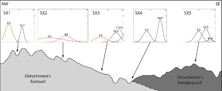
These older ages are preserved also in the older peaks of samples from most of the tributaries draining the southern margin of the basin, particularly in those draining the bedrock at the hanging wall of the Gediz detachment (samples SX1-2) and klippen laying of top of the detachment surface (sample SX5 and probably sample SX3).
Samples from the southern margin provide interesting information also on variations in the cooling pattern along the strike of the main graben bounding structures that are involved in the exhumation of this sector (Fig. 9 and 10). Samples SX3-5, from catchments draining the Salihli granodiorite, the mylonitic-to-ultracataclastic Gediz detachment shear zone and the footwall of the detachment, yielded very young AFT cooling-ages (Pliocene or younger) for their drainage areas that are consistent with the existing bedrock low-T thermochronology in the same area, that also show a rejuvenation trend in the direction of the dipping of the detachment (Gessner et al., 2001; Buscher et al., 2013). On the contrary, sample SX1, from a catchment draining only Menderes metamorphic rocks (Çine nappe) at the hanging wall of the Gediz detachment, yielded an older age (9.3 ± 2.8 Ma) for its younger age-peak, confirming the structural relationship between this sector and the detachment fault and pointing to a different cooling/exhumation history for this portion for the southern margin. Moreover, in sample SX2, whose drainage area comprehends both rocks at the hanging wall of the detachment and partially rocks at its footwall, the younger age-peak (6.4 ± 1.9 Ma) seems to be influenced by the younger grain-ages of both sectors (around 10 Ma to the SE and less than 5 Ma to the NW), toughening this interpretation. All these data seems to suggest that the western portion of the southern margin (the Salihli area, where the Salihli granodiorite and the mylonitic-to-ultracataclastic Gediz detachment outcrop) experienced a younger and independent phase of exhumation with respect to the eastern portion (the Alaşehir area).
32
In our opinion, the cooling pattern of the southern margin is somehow strongly influenced by the presence of the early-middle Miocene granodioritic Salihli pluton. In this light, bedrock exhumation ages calculated on the granodiorite are not extendible along the whole strike of the southern margin, because these are probably related to an extremely localized event.
33 Figure 9: (on the previous page) Radial plots reporting apatite fission track grain-age distribution for the modern
rivers’ detrital samples. In the central column samples from the modern Alaşehir /Gediz river (MAIN1-5), in the left column samples from the northern (right) tributaries (DX1-3) and in the right column samples from the southern (left) tributaries (SX1-5). Radial plots with a light-grey circle to the left of the central age are relative to tributaries draining the footwall of the Gediz Detachment (SX3-5), while those with a dark-grey circle to the left of
the central age are relative to tributaries draining its hanging wall (SX1 and DX1-3); radial plot with a shaded dark-to-light-grey circle to the left of the central age is relative to the southern tributary draining both the footwall
and the hanging wall of the detachment (SX2).The thick blue arrow indicate the direction of the main river flow, while the thin blue arrows show the position of the confluence of the sampled tributaries in the main river with respect to the position of the samples from the modern Alaşehir /Gediz river. Light-red lines in the radial plots show age peaks (with relative value in red expressed in Ma) for the different populations retrieved after
grain-age deconvolution with BinomFit software (Brandon, 2002).
Figure 10: Schematic cross-section (see Fig. 11 for the location) showing the relative position of samples
collected in tributaries draining the southern margin of the basin (Gediz Detachment side) and the structural relationship between their drainage areas. Results for detrital apatite fission track grain-age distribution is represented in probability density plots with age-peaks expressed in Ma; red peaks are those relative to the
youngest exhumation event. It is clearly visible that this last event involved only the footwall of the Gediz Detachment (western part of the margin), confirming that this structure does not bound the whole southern
margin of the basin.
5.3. Considerations on apatite fertility and short-term erosion pattern
By measuring apatite fertility in the different source areas, we found that there is a strong difference in the mean fertility between the outcropping area of the Neogene Salihli granodiorite and the Gediz detachment (186 ppm) and in the rest of the source area (551
34
ppm) (Fig. 6). This means that in the evaluation of the sediment contribution on the main Alaşehir /Gediz river, the number of apatite grains with a grain-age signal ascribed to the detachment’s area should be multiplied by a factor of 3 in order to properly estimate its contribution to the whole sediment load.
Considering that the lithologies outcropping in the drainage area of the Gediz river upstream the confluence of the Alaşehir river (i.e. the Northern Menderes Massif) are the same that outcrop at the northern margin of the Gediz graben, we found reasonable to extrapolate the apatite fertility value calculated from the left tributaries (551 ppm) to this area.
Considering relative apatite contribution from each drainage area and their mean apatite fertility, we defined the contribution to the total sediment load in the Alaşehir /Gediz river of the outcropping area of the Gediz Detachment and its footwall (including the Salihli Granodiorite); we found that it represents 6% of the total sediment load in sample MAIN3, 33% in sample MAIN4 and 8% in sample MAIN5, while all the remaining contribution is related to the Menderes metamorphic basement. These values can be divided by the relative drainage area to get relative (nondimensional) erosion rate (Fig. 11). For sample MAIN3 we found that the erosion rate of the easternmost portion of the detachment’s area is more or less equal to the one of Menderes metamorphic basement at the margins of the Gediz Graben. For sample MAIN4, that is much more representative of the contribution of the Gediz Detachment to the total sediment load of the Alaşehir /Gediz river, we calculated that the erosion rate of detachment’s area and its footwall is ~3.5 times higher than in the rest of the drainage area. The difference in the erosion rate of the Gediz Detachment area between its central part and its eastern termination (i.e. between sample MAIN4 and MAIN3) is in our opinion related to the fact that the latter area is in close proximity of the hanging wall, thus being uplifted and eroded less than the rest of the structure. For sample MAIN5 we could finally calculate also the ratio of the erosion rate of the Northern Menderes Massif with respect to the other drainage areas. In fact, between sample MAIN4 and MAIN5 the drainage area of the Menderes metamorphic basement in the Gediz Graben remains almost the same; in this way the difference in the contribution to the sediment load of the Menderes metamorphic basement above the Gediz Detachment between the two samples is related only to the contribution of the drainage of the Northern Menderes Massif. Hence, we found that the erosion rate of the Northern Menderes Massif drained by the Gediz river is ~3 times
35
higher than in the metamorphic basement at the margins of the Gediz Graben and slightly lower than in the Gediz Detachment area.
Figure 11: Short-term erosion pattern of the drainage area of the Alaşehir /Gediz river; relative dimension of the
white cubes represents the relative short-term erosion rate (nondimensional) of each sub-basin; the red line indicates the trace of the schematic cross-section of Fig. 10. The erosion is now focused on the outcropping
area of the Gediz Detachment and of its footwall (including the Salihli granodiorite).
Buscher et al. (2013) quantified the erosion rate of the Gediz Detachment area by using cosmogenic 10Be, obtaining a mean value of 110 ± 10 mm/Ka. By integrating this value with our results and we obtained an erosion rate of 31 ± 2.8 mm/Ka for the Menderes metamorphic basement at the hanging wall of the Gediz Detachment at the Gediz Graben margins, and a rate of 93 ± 8.4 mm/Ka for the Northern Menderes Massif drained by the Gediz river.
36
The fact that the erosion rate of western part of the southern margin of the basin is much higher than in the eastern part and in the northern margin might be related to the fact that the youngest exhumation event that lead to the surface the Gediz Detachment (revealed by its younger AFT ages) generated a localized recent uplift that did not affect its hanging wall, thus reflecting on the short-term erosion pattern. The fact that the highest peaks of the region (the Bozdağ range) are located right at the footwall of the detachment seems to support this interpretation. In our opinion, this is another evidence that the presence of the granodioritic Salihli pluton might have played a major role in the exhumation of the Gediz Detachment’s ductile-to-brittle shear zone.
The relatively high erosion rate of the Northern Menderes Massif with respect to that of metamorphic basement surrounding the Gediz Graben is, in our opinion, related to the fact that in this region the Gediz river drains also Neogene NE-trending continental basins that are reasonably eroding much faster than their metamorphic basement.
5.4. Schematic evolution of the Gediz Graben
To summarize our results, in Fig. 12 we schematically represented the evolution of Gediz Graben. Previously published bedrock apatite fission track data (Gessner et al., 2001), together with our detrital ages from the northern modern tributaries, show that the northern margin of the basin was already exhumed during Oligocene or Early Miocene at the latest, so did not experienced relevant exhumation during the whole evolution of the graben.
The detrital apatite fission track ages recorded in the lower part of the stratigraphic sequence (i.e. Alaşehir Fm. and lower Ҫaltilik Fm.) reflect the fact that the source areas of these deposits where not undergoing major exhumation by the time of the first phases of basin formation (i.e. Middle Miocene: Ҫiftçi & Bozkurt, 2009; this study. Fig. 12a).
During Late Miocene, a major phase of exhumation involves the southern margin of the basin and is recorded in the detrital apatite fission track ages of all the upper part of the Neogene-to-Quaternary sedimentary sequence (Fig. 12b), starting from the middle Ҫaltilik Fm. This phase is controlled by the brittle high-angle normal faults bounding the southern margin of the basin, that lead to exhumation of their footwall and produced significant accommodation space at their hanging wall for the deposition of the upper Ҫaltilik Fm. and Gediz Fm. between
37
Late Miocene and Pliocene. These normal faults rooted on the detachment shear zone at depth, that at that time was not already exposed at the surface (e.g. Gessner et al., 2001; Buscher et al., 2013; this study) and was rather under conditions for ductile deformation at least until Messinian time (Lips et al., 2001).
The last exhumation phase recorded in the southern margin by both bedrock and detrital apatite fission track data (Gessner et al., 2001; Ring et al., 2003; Buscher et al., 2013; this study) occurred during Late Pliocene – Early Pleistocene and involved only the western part (Salihli area) of the margin, where it is presently exposed to the surface the Gediz Detachment ductile-to-brittle shear zone and rocks at its footwall, including the latest Early Miocene Salihli granodiorite (Fig. 12c). It is likely that this differential exhumation produced a differential uplift between the eastern and the western sectors, which is closely reflected by many present-day features such as the topography, the short-term erosion pattern and the rocks exposed at the surface. As a matter of fact, the sector of the margin that experienced the last exhumation phase (to the W) is topographically much higher than the eastern part and, in general, than the whole Menderes Massif, with the peaks of the Bozdağ Range located in this area representing the highest elevations reached in the present-day Menderes Massif’s topography. Moreover, the short-term erosion pattern (Fig. 11) show much higher erosion rates in the Gediz Detachment area, which might likely be related to the highest relief produced by the last exhumation event. Basement rocks outcropping in the eastern sector of the basin margin do not show any ductile deformation related to the Neogene extensional phase that generated the basin, thus suggesting that in this portion is exposed an higher crustal level than the in the western sector; finally, in the Alaşehir area are visible in outcrop the oldest sedimentary units of the Gediz Graben fill which might have been more uplifted in the Salihli area above the Gediz Detachment and then eroded, thus explaining the differences in the outcropping stratigraphic sequence between the two sectors (see Fig. 7).