ISSN 1828-5961
Ana Clara Mourão Moura Architetto e urbanista. Specialista in Pianificazione Territoriale e Urba-na, Dottorato di ricerca in Geografia (GIS) presso l’Università Federale di Rio de Janeiro. Professore associato presso l’Università Federale di Minas Gerais, Facoltà di Architettura. Do-cente di Progettazione Urbanistica, coordinatore del Laboratorio GIS. Co-ordina il gruppo di ricerca del CNPq: “GIS nella gestione del paesaggio e dell’ambiente urbano”.
Il testo descrive lo stato dell’arte delle tecnolo-gie GIS nella pianificazione e processi di gestione delle aree urbane. Presenta l’evoluzione più re-cente di metodologia e applicazioni GIS, illustran-do in che moillustran-do queste risorse hanno cambiato il nostro modo di rappresentare e sporgente territorio. Si annuncia l’arrivo di nuove logiche di rappresentanza territoriale, tra cui azimuth visualizzazione, conoscenza di mappe mentali, e il processo di Parametrizzazione. Sottolinea le tendenze e i valori per i sistemi informativi, come essere inter-operativi, creando ritratti interpre-tativa della realtà, producendo simulazione di scenari, investendo nella visualizzazione come supporto alla decisione. Si difende che stiamo vivendo un nuovo paradigma nella pianificazione territoriale: la Modellazione Parametrizzata della Occupazione Territoriale.
The text discusses the state-of-the-art of GIS Tech-nologies in planning and management processes of urban and architectural spaces. It presents latest’s evolution in GIS methodology and ap-plications, discussing how these resources have changed our way of representing and projecting the territory. It announces the arrival of a new lo-gic on territorial representation, among which is azimuth visualization, considering mental maps, and the process of Parameterization. It points out tendencies and values, such as being inter-ope-rational, creating interpretative portraits for re-ality, producing simulated sceneries, investing in visualization on decision making, fully employing geo-technologies. It defends that there is a new paradigm on territorial planning: the Parametric Modeling of Territorial Occupation.
Progettazione paesaggistica o parametrizzazione? Recenti tendenze in geo-tecnologie per la
rappresentazione e pianificazione del territorio urbano.
Landscape design or parameterization? Recent tendencies in geo-technologies
for representing and planning urban territory
Parole chiave: GIS; parametri urbani; simulazione
della progettazione del paesaggio; modellazione parametrizzata della occupazione territoriale;
Keywords: : GIS; urban parameters; landscape
design simulation; parametric modeling of territorial occupation
ISSN 1828-5961 Landscape design or parameterization? Recent tendencies in geo-technologies for representing and planning urban territory
1. INTRODUCTION
There is a significant paradigm change on urban design, basing on processes of landscape requalification, urban surgeries guided by entrepreneurship, and more active participation of city’s users in decision making. This brings a commitment to use more effective forms of representation for planning proposals and environment transformation management. New processes demand predictive studies, simulating urban landscape intervention and composition compiling expressive amounts of information, in order to aid decision making. Thus, geo-technologies, especially Geographic Information Systems (GIS), structured in their applications within a premise of GeoDesign occupy an important role in the architect and urban specialist’s profession.
Urban designing begins in diagnostic studies of a complex range of variables, permitting different landscape interpretations. Analysis of spatial models result in portraits of urban reality, allowing for transformation simulations, foreseeing tendencies and evaluating potentialities, restrictions and conflicts of interest, within a territory’s occupancy.
After a phase in which a “city design” was common, ways of intervention in urban landscape today, both in order to propose new occupancies as well as edifying land plots and improving already occupied areas, follows two lines. They are based on action of small temporal and spatial scale, in a process characterized by urban surgeries, and in wide temporal and spatial scale, in a process of parameterization of limits and expectations.
The procedure of urban surgeries is recognized by punctual intervention through large engineering works, both in infra-structure, as in territorial occupancy and expressive occupancy. These are elements which act as catalysts for complex transformations in land use and occupancy. This type of intervention is characterized as managing or urban entrepreneurship, since the association between public and private capitals is common,
with benefits for both sides (Harvey, 1992 and 1995).
Managing is characterized by private capital in public enterprises, earning direct or indirect capital. Direct gains occur by constructive coefficient increase authorizations or by occupancies trough new real-estate enterprises. Indirect gains occur by valuing the intervention area and consequently the real-estate profit gain results from the increase of the land’s interest.
In the beginning of these processes, managing was also associated with actions of city marketing or gentrification (term used by Ruth Glass in 1964 and Neil Smith, in1980).
Gentrification is characterized by rehabilitating deteriorated urban areas, but associated to the expulsion of traditional residents, belonging to less favored economic classes, in order to increase property value and improve real-estate market conditions.
City Marketing, on the other hand, is characterized by building and selling an image, associated to a certain quality which is sold as a commodity. There are many examples of when cities build an image (which can be innovation, tradition, safety, environmental quality, urban effectiveness, pungent economy, and so on) and sell the idea, in order to attract capital. The expectation is that from urban surgeries or punctual investments, a valuing of the region occurs, and profit is obtained from new real-estate and economic operations.
Urban surgeries result in complex projects and need to be well documented. Geographic Information Systems’ technologies are very useful in composing spatial analysis which identifies territorial possibilities and limitations. The other course of action in today’s urban planning, which is responsible for transformations in large spatial and temporal scales, is represented by defining conditions limits of territorial occupancy, which means the establishment of urban parameters.
Parameterization itself is not a new principle, but is born from division laws, in municipal development plans, their land use and
occupancy laws, and edification codes. In different scales, parameterization aims to define limiting conditions or envelopes, in scales regarding both division and plot occupancy or building.
In division laws, parameters are established such as maximum and minimum dimensions for land plot, roads, blocks, and so on. In land use and occupancy laws, tables are created, detailing zone, occupancy typology, and defining back spaces for constructions, occupancy rates, occupancy coefficient, and so on. In edification codes, references for minimum dimensions are established for several components of a building, aiming to guarantee a minimal quality. Therefore, parameterization, regarding tables of urban parameters specifications, is not a new idea. Its application results in urban landscape conformed throughout time, by the sum of interventions by each city’s user, in a wide space scale.
What is special in parameterization today is the possibility to study each case, and analyze it individually according their different conditions. In the past, urban parameters were used in a homogenous manner, within a region defined by urban zoning. Now, new technologies allow each unit to be individually studied and parameters to define a volume’s envelope to be built and to be adjusted according to the capacity of the region where it is inserted. Legislation supporting the principal of different responses to each unit of occupancy is the principal of property’s social function, which defines property as private, but its use is mainly social. Therefore, it is possible to respond differently to different owners regarding possibilities related to their property, without this meaning a direct rights decrease, but a search for balance in occupancy.
This expected flexibility in territory occupancy, especially regarding plot occupancy, needs to be aid in new resources for simulation of volumetric occupancy composition, in process we chose to call “parameterized modeling of territorial occupancy”.
ISSN 1828-5961 Landscape design or parameterization? Recent tendencies in geo-technologies for representing and planning urban territory
representation and storing and management of territorial information, the so called geo-technologies, are no longer used only in analysis processes, but is widen in supporting territorial planning and management, through GeoDesign processes.
2. TIMELINE IN GEO-TECHNOLOGIES
We are living in a unique moment, when it comes to urban spatial analysis. Information technologies and especially geo-referenced information begun to be widely familiar by users within this field of knowledge, allowing us to use it properly as an instrument for applying diagnostics and predictive models, to aid decision making. Along with growing accustomed to their use, we are beginning a new paradigm in spatial representation and analysis, shaped by inter-operational principals between systems, strong investments in communication, and offers of project operation tools and real time simulations.
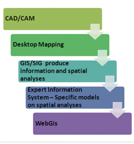
After 25 years, today is a moment of growing past previous stages in environmental and urban studies. Geo-technologies, through Geographic Information Systems’ creation, have employed in some countries already in the 1960’s, but we can say that geo-processing was properly and widely used in Brazil, from the 1980’s.
All begun with CAD/CAM (Computer Aided Design, Computer Aided Manufacturing), which represented a first paradigm shift when breaking up territory’s representation in layers of information, allowing data geo-referencing in flat projections (which, at this point, still ignored deformations in Earth’s surface) and allowing simultaneous visualization of layers, as well as combination of layers in cartographic communication. Note that the process divides in variables, here represented by layers, in order to favor visual combinations, and aiding the observer creating mental syntheses. How vestiges of ancient forms of representation, such as analogical drawing, difficulties remained regarding topologic corrections, of primitive graphics, and the lack of comprehension that
digital cartography does not accept scales, it works in a 1:1 rate, when before, its goal was to divide, in order to construct.
When CAD was still the most common tool, users tried to associate to alphanumeric attributes to graphic primitives, using tags, what allowed simple consultations. First users needed to use programming language, in order to associate the previous data base. Not long after that, new software was create, classified as Desktop Mapping, and they would associate drawing and tables, responding to these two main questions: “were and which are the characteristics? And “were are located certain characteristics?. These new applications brought the possibility to apply different representation models of Earth, considering its curvature, and allowing for an adoption of geodesic referential for the world and each country, as well as converting a system into another.
The Desktop Mapping period was when were most popular thematic maps resulting from data bases, in a way spatial analysis was widely aided. Then large quantities of maps were created, presenting portraits of reality somewhat more complex than before, but still presenting incipient synthesis capability. Technical reports were characterized by wide collection of thematic cartography, used as communication cartography.
It did not take long for the introduction of spatial analysis’ models into software’s repertoire, taking a step forward through variable combination by map algebra. The moment was particularly interesting for using the systemic logic in environmental and urban studies. Proceedings of variable pondering, proposition of equations responding for the investigated phenomena, scientific investment in decoding statistical and geo-statistical studies in order to create maps of variables territorial distribution, occur.
Great old thematic map collections (which aimed to communicate isolated, or, at best, overlaid, variables) were substituted by synthetic maps (portraits of the investigated
reality). As every portrait, these maps are representation models of a phenomena or factor, following conceptual, methodological and temporal selections.
A model is a conceptual selection, once it represents a goal or a point of view, from a researcher (or a group of researchers), as well as their personal views or theoretical positions interfere in the choice of variable, the way they combine, and values attributed.
A model is a methodological selection, once it responds to logic, equation, or paths chosen for the investigation and composition. It is a temporal selection, since it corresponds to a period or date, and variables are involved in constant transformation, each one in its temporal scale. Finally, a model is a spatial selection, since it is a territory to be investigated is chosen and delimitated, and depending on how the selection is done, it is important to consider edge effects, and vicinity influences in the installation, presence and diffusion of events and phenomena within the territory. Therefore, Geographic Information Systems presented classic models for combining variables for easy applying map algebra, or they have allowed users to propose their own models, by dividing matrix’s variables and create combination logics between them. The process was so expressive that it generated specific software for model execution, the so called Expert Information Systems. The development of spatial analysis (from these new resources) was significant, but it has maintained the “divide to create” paradigm, in order to favor territory representation and analysis in its variables or main components, so that it promotes their integration, and try to reproduce reality’s complexity. Once the territory is reproduced in a satisfactory manner, even considering simplifications inherent to models or reality’s complexity, the users actually had in their hands a digital tool, composed of a virtual mirror of territory, and would allow change simulations, transformation predictions, and understanding phenomena’s values and propagation.
ISSN 1828-5961 Landscape design or parameterization? Recent tendencies in geo-technologies for representing and planning urban territory
there are many users utilizing geo-processing tools for collection, storing, representing and analyzing spatially geo-referenced data. Geographic Information Systems and their tools are widely announced, and are well used as aids to decision making. It is necessary to stress out that geo-processing does not offer single and unquestionable responses for space studies, but presents points of view guided by different criteria, which are only aids for decision making, and are the specialist’s responsibility, which chooses one of the following paths. For the correct employment of GIS in spatial analysis, the first step, and one of the most important ones, is the clear definition of goals. It is a mature consideration of goals, which will validate or not the variables choice, and spatial analysis models to be used, in a way it will either validate or not the answers obtained. Thusly, proceedings based on geo-technologies are the way to have reproducible criteria for space analysis undertaking.
Following up computer net’s influence worldwide, also Geographic Information Systems were adapted to work under www, using WebGIS applications. Technologic development and user’s interest would then grow exponentially, but there were still an impediment to be conquered: authorization for wide circulation and access to data collections, and proposing quality control for spatial data. (Figure 1).
Therefore, recent scenario was one of recognizing Geographic Information Systems’ potentials, as well as considering communication and information exchange processes, and initial legislation regarding propagation of information. In a process continuously more integrated and global, geo-technology tools started to respond to the following values: wide communication with different users; wide inter-operability; and wide promotion of systemic approach, by modeling processes and building interpretative portraits and simulators for reality.
One more transformation of territory representation technologies would promote
values and paradigm changes: BIM – Building Information Modeling. BIM is used in object representation and project proposals, but particularly in designing, architecture and building engineering. BIM logic is “create to divide”, which is the exact opposite of GIS logic, which is “divide to create”. In BIM, the object is represented as an object, in four dimensions, and its representation is undertaken in different plans (plan, cut, façade, data base, and so on).
It is the automatic result of dividing an object. Proposed changes in the object automatically reflect in its different representation forms. The force of the fourth dimension in representation procedures, proposition, simulation, and intervention on to space reality was already foreseen. Azimuth view in representation was already a strong tendency, comparatively to zenithal and cartographic view. To bring a user into comprehending dynamic and interactive maps was already
Figure 1 - Timeline in Geo-Technol-ogies
ISSN 1828-5961 Landscape design or parameterization? Recent tendencies in geo-technologies for representing and planning urban territory
being announced as a tendency. Since the 1960’s and 1970’s, studies on how mental maps are formed and how the relationship between visible and virtual (represented) realities is structured was already inviting attentions, and augmented reality was very well accepted. We were at one step from a new paradigm in geo-technologies, and to integrate to GIS and BIM a wide investment in representation technology, so that tools would favor projects proposals
in real time (by augmented reality), and that users could create their landscapes using parameterization processes. These are, within the context of urban landscape composition, the translation of certain legislations and legal norms for the construction of possible scenario resulting from the established parameters. Therefore, form what came initially from game applicative, with significant communication ability, new software were introduced into
the market, allowing, in a near future, the integration between GIS and BIM, by maintaining as its primary goal and function, the aid to creating augmented reality projects and using simulations of resulting landscapes in parameterization processes. It is a new paradigm, a new way to work with spatial information. In the inexistence for a new term representing this phase, this new paradigm, we propose the term “Parametric Modeling for Territory Occupation”.
For this new moment and territorial representation paradigm within urban management, fundamental tools will be developed, for the search for the balance of anthropic sustainable occupancy of territory. New technological conditions will favor, above all, territorial governance processes, given that they will act as a communication bridge between technical, administrative and community sectors of society, since the proposals for the territory will be properly simulated, reviewed, communicated and interchanged. It is a further step into a real participative planning, since there will be a wider condition for comprehending proposals and norms. It is hoped that science and technology will be invited to collaborate in decision making processes and guarantee anthropic action in environments aiming for a dynamic balance. (Figure 2).
3. APPLICABLE LEGISLATION AND NEW OPEN DOORS INTO URBAN PLANNING AND MANAGEMENT AIDED BY GEO-TECHNOLOGIES
Exponential technological development and professional interest of architecture and urbanism has touched in the absence of good quality data and spatial resolution, as well as in authorizing access to existing data. In Brazil, two juridical peaces have widened conditions: Decree 6.666 of 2008, from the Ministry of Planning, and the Ministerial Ordinance number 511, from the Ministry of Cities, published in 2009.
Decree 6.666 of November 27th 2008 institutes
Figure 2 – Basic knowledge to use Geo-Technologies
ISSN 1828-5961 Landscape design or parameterization? Recent tendencies in geo-technologies for representing and planning urban territory
in the Executive the National Spatial Data Infrastructure (NSDI) (BRASIL, 2008). It aims to maximize the availability of public sector information, for use and reuse, emphasizing transparency and good governance; stimulates access and reuse conditions of public sector information; increasing its access, use, integration and share.
The goal of a Spatial Data Infrastructure (SDI) and, more specifically of a National Spatial Data Infrastructure (NSDI), is to improve information access and propagate its content electronically via internet, motivating its inter-operation quality. To make GIS inter-operational is to make possible for data combination in distinct sources. In syntheses, it establishes a total of availability standers for access to territorial data, in a way to create an integrated and systemic mosaic for geographic information. Special Data Infrastructure brings as benefits, according to Castro (2011): data access throw recognizable patters; possibility to “connect” to several data providers; facilitated search; and the fact that any equipment with internet access may use SDI.
Other then favoring data access, these norms aim to establish patterns for data availability, in a way to allow information integration without risks of taxonomic error, spatial errors, or bad information quality. The goal is that in the future, several territory managers will be involved in updating and integrating their variables into a data base system, in wide scale. On the other hand, Ordinance number 511, from the Ministry of Cities in December 7th
2009, published by the National Official Journals in December 8th 2009, institutes Directives for
Creating, Instituting and Updating the Territorial Multiuse Register (TMR, in Portuguese CTM) in Brazilian Municipalities (BRASIL, 2009).
It consolidates intentions within the City’s Statute (Federal Law number 10.257, from July 2001), since, in order to guarantee their goals of emphasizing agrarian issues and social recognition of property, the first step is to construct a detailed portrait of a territory. This portrait characterizes territorial units in
Figure 3 – State of the art and state of design in Geo-Technologies
ISSN 1828-5961 Landscape design or parameterization? Recent tendencies in geo-technologies for representing and planning urban territory
their land dimensions, limits, possession and property.
Since 1988’s Federal Constitution, Brazilian municipalities and counties were benefited by increased autonomy, decentralization processes, and democratization of how cities are managed which resulted in a financial autonomy. However, at the same time benefits were increased by decentralization, responsibilities were also amplified. Municipalities have to exercise their local authorities and territorial responsibility, which means adequately amassing and using their resources. This also means a greater responsibility in decision making processes in the activities of planning and managing, since all projects must be properly justified. Therefore, there is no way to act responsibly in municipal management decisions without a detailed, faithful and updated portrait of territorial reality. This means structuring and updating TMR.
The ministry Ordinance orientating TMR also assumes voluntary joining of Brazilian municipalities. The Ordinance’s Article 20, establishes the multiuse of TMR and is assured by information integration of other systems to the common basic system, of minimal content, which favors updating.
In Brazil, although NSDI norms do not establish TMR’s content, there are two open doors for valuing structure and propagation of geo-referenced data, for aiding planning and management actions. These are the Ministry Ordinance, which instructs on the importance and how the TMR should be created, and the Ministry Decree, which verses on the importance of data availability.
The expectation is that a legal support will mean diminishing obstacles for new tools to be employed and the area’s development, presenting as challenges technological development and better approximation of on-technical community as collaborators for producing information and as interested parties in the information about their territory.
4. STATE-OF-THE-ART E STATE OF DESIGN IN GEO-TECHNOLOGIES
When facing the fast and expressive evolution of information technology systems, which develop in the wide possibilities offered by GIS and BIM, as well as by the knowledge that all must be clearly structured in logic processes of PSS (Planning Support System) kind, we question if we are not already employing new methodologies and new tools, or if we are still maintaining our old way of thinking and are merely adding new tools and their benefits. There are important guiding questions for main researchers in architecture and urban planning today: How to measure the value of urban and environmental landscape? How to predict consequences of intervention in the conjoint of an urban landscape? How to have reproducible criteria to analyze urban landscape?
It´s possible to observe new values to be added in tools and processes of planning, representing the state-of-the-art and the state of design in geo-technologies. (Figure 3).
When observing tendencies, it is interesting to understand what is “designing with” new information technologies and geo-technologies’ resources, both to urban and to architectural scales. Since this is a complex issue by nature, it will be studied in this publication through further developing the following inquiries: - How to undertake territorial planning,
especially in municipality regions’ scale for complex spatial and social reality, and how to make different stages of project proposition process public and understandable? How are we in maturity terms for planning and consideration of several of the variables involved?
- How to evaluate transformation conditions for an urban territory, regarding its capacity for cargo and change resilience, according to the existing infrastructure, cultural values, environmental conditions, limitations and potentialities?
- What new juridical norms and instruments (which model today Brazilian’s landscape) are proposing and how geo-technologies
can aid decision making and application of new logics of urban land use and occupancy management?
- How to use new information technologies’ resources, both to urban scale as to architectural scale, as tools for designing projects and not only as tools for structuring data bases and spatial analysis? Which are the new tendencies in this field? Are we using old technologies and only changing the instrument we use?
- Is it possible to begin immediately applying geo-processing resources in a City Hall, in order to support diagnostic processes of the existing reality, and aid the elaboration of municipal development plans, basing on free software, public data and technical team’s habilitation?
- What is urban quality of life, from the point of view of vegetation cover, green areas and environment built with these variables? Landscape metrics can be used to aid diagnostics and proposal studies?
- What is the role spatial analysis models play in territorial management studies? How to make good use of influence area models, territorial displacement studies’ models, and variable combination models?
- How to aid choices and urban intervention in marginal areas and areas presenting social, environmental and physical frailty? What role do geo-technologies play in this process? How to use communication tools and data management, in order to convey transparency to processes and justify choices and decision making? Do marginal areas, recognized as urban slums (favelas), present an essence which characterizes them? - How to involve community in the process of
designing their own landscape? The forms of communication used today in public hearings of projects and programs, or else, available in the media, are easily understood by the community? Are we fully conscious of what is approved as a parameter for modeling collective landscape? What does it mean to have a right to landscape?
ISSN 1828-5961 Landscape design or parameterization? Recent tendencies in geo-technologies for representing and planning urban territory
BIBLIOGRAFIA
Brasil, (2001), Lei Federal nº 10.257 de 10 de julho de 2001: Regulamenta os Arts. 182 e 183 da Constituição Federal, estabelece diretrizes gerais da política urbana e dá outras providências, Governo Federal, Brasil.
Brasil, (2008), Decreto 6.666 de 27 de nov de 2008: Institui na esfera do Poder Executivo federal a Infraestrutura Nacional de Dados Espaciais – INDE, Governo Federal, Brasil.
Brasil, (2009), Portaria Ministerial no. 511 de 07 de dez. de 2009, Ministério das Cidades: Institui Diretrizes para a Criação, Instituição e Atualização do Cadastro Territorial Multifinalitário (CTM) nos Municípios Brasileiros, Governo Federal, Brasil. Castro, Dayan Magalhães, (2011), Visualização de dados geográficos urbanos na Web: estudo de caso da Região Metropolitana de Belo Horizonte, IGC/UFMG- Análise e Modelagem de Sistemas Ambientais.
Glass, Ruth, (1964), London: Aspects of change, Centre for urban studies, London.
Harley, David, (1992), Condição pós-moderna, Edições Loyola, São Paulo [The condition of posmodernity]. Harvey, David, (1995), Espaços urbanos na “aldeia global”: reflexões sobre a condição urbana no capitalismo do final do século XX, in Cadernos de Arquitetura e Urbanismo, Belo Horizonte 4(1). Smith, Neil, (1980), New globalism, new urbanism: gentrification as global urban strategy. Graduate Center, City University of New York, New York, pp. 427-450.
- How to explore several landscapes’ registers, in a way to configure its image and make this communication process a way to identify the place’s essence? Is there still room for traditional representation, when considering the innovations provided by information technology? How to link different forms of communication about urban landscape and the important goal to stimulate the bonds between mental image, real image, and represented image?