THE USE OF REMOTE SENSING FOR WATER PROTECTION IN THE KARST
ENVIRONMENT OF THE TABULAR MIDDLE ATLAS / THE CAUSSE OF EL HAJEB/
MOROCCO
A. Muzirafuti1*, M. Boualoul1, G. Randazzo 2, S. Lanza2, A. Allaoui1, H. El Ouardi3, H. Habibi3, H. Ouhaddach3 1 Team of applied geophysics, Nat Ress. and Heritage, Dept. of Geology, Fac. of Sciences, University of Moualy Ismail, BP. 11201
Zitoune, Meknes, Morocco – (muzansel, abdelhamid.gaig11)@gmail.com, [email protected]
2 Section of Earth Sciences, Dept. of Math and Computer Science, Physical Sciences and Earth Sciences, Univ. of Messina.Via F. Stagno d'Alcontres, 31 98166 - Sant'Agata di Messina, Messina, Italy – (grandazzo, lanzas)@unime.it
3 Team of tec mapping, Dept. of Geology, Fac. of Sciences, University of Moualy Ismail, BP. 11201 Zitoune, Meknes, Morocco - [email protected], (habibim58, hafida.ouhaddach)@gmail.com
KEY WORDS: Causse of El Hajeb, Water protection, Turbidity, Remote sensing, Karst environment ABSTRACT:
Deep water bodies constitute the strategic water reserves of Morocco. These natural resources are used in many activities such as irrigation in agriculture, and, more importantly, they are the source of fresh drinking water for the local population. However, these resources are vulnerable to anthropogenic and natural phenomena due to ongoing climate change and the increase in population growth. To contribute to the recent initiative for the protection of the karstic environment of water springs in the Tabular Middle Atlas of El Hajeb, the present research work aims to characterize different karst landforms in Liassic carbonate rocks of the Tabular Middle Atlas in the Causse of El Hajeb, where pollution identified in water samples in this region originates. Satellite imagery (Sentinel-2, Landsat, Terra-ASTER, ASTER-GDEM) and GIS tools were used. Based on surface reflectance of dolomite and limestone, especially in shortwave infrared, we delineated the extent of carbonate rocks and areas with intense human activities. Fractures affecting these Liassic rocks were extracted mechanically and manually after the application of Sobel operator filter in N, S, NE and SW main directions. The results show an improvement and a better understanding of the hydrogeological system of this karst environment, in particular the location of new faults identified in NE-SW and NW-SE fault systems which involve infiltration of surface water and groundwater drainage respectively. The percolation of slightly acidic water through these fractures has gradually created cavities and sinkholes which are believed to be the origin of turbidity observed during the analysis of the water springs.
* Corresponding author
1. INTRODUCTION
Remote sensing has been used in many environmental studies (Julien, 2018) because of its capacity to provide information rapidly on large and hard-to-reach areas. Recently, many programmes such as ASTER, Landsat and Copernicus Sentinels have provided satellite imagery of both high temporal and spatial resolutions free of charge. These data, combined with ground measurements, can lead to solutions for modern challenges such as climate change, natural hazards and increasing population growth. We used this technology in a region which is both sensitive and vulnerable to these phenomena, the karst environment of the Tabular Middle Atlas (TMA) of Morocco, in order to identify its different surface karst landforms.
The TMA of Morocco contains an important water reservoir, located in Liassic carbonate rocks (dolomite and limestone), used for everyday activities by 4236892 population living in Fez-Meknes region, according to 2014 national census of population in Morocco. Because of its importance and the value it holds in the economy of the region, it has been described as château d’eau (SRAT de la Région Fès Boulemane, 2013). Recent studies conducted in this region (Howell, 2016) show that water quality is deteriorating due to anthropologic activities and natural processes. The present study proposes the use of earth observation and free available data to map various forms of karst (avens, dolines, poljes...) and fault systems; these are the most fragile hotspots where water from the ground
surface charged with with pollutants can easily infiltrate and reach under groundwater bodies. We intend to answer the question related to the part played by each fault system, in order to find out which one is responsible for the infiltration of surface water and consequently is contributing to the development of sinkholes, shown in figure 3. At the time we want to identify which fault system drains water from the Causse to the basin.
The aim of this study is to enhance the understanding of the hydrogeological system of the TMA by adopting a methodology combining space technology and ground-based field work, in order to identify : (1) the direction of the fault systems involved in water infiltration and in development of different karst landforms, (2) the predominant location of karst landforms responsible for the turbidity and chemicals observed in water springs, and (3) human activities contributing to the degradation of water reservoirs.
2. METHODS AND MATERIALS 2.1 Area of study
The TMA of Morocco is located in the northwest of Morocco, bordered to the north by the Saiss basin, to the southwest by the Hercynian Massif Central and to the west by the pleated Middle Atlas shown in figure 1. It holds an important water reservoir, located in Liassic carbonate rocks (dolomite and limestone). It is characterized by a Mediterranean climate with annual
precipitation (rain and snow), varying between 700 mm and 900 mm for the period from 1973 to 2008 at Ifrane. The region is occupied by a large number of water springs, such as Ain Aguemguem, Ain Bittit, Ain Boujaoui, Ain Ribaa, Ain Marrouf, Ain Amjrar, Ain Kadhem, ain Zerouka, and lakes called dayets; these are the easily observable karst landforms created by progressive erosion of limestone by water infiltration along faults.
Figure 1: Modified geological stretch map of the TMA
Spectral signatures, shown in figure 2, extracted from Copernicus Sentinel-2 images, show dolomite and limestone with high reflectance in shortwave infrared, vegetation in near infrared and water in blue. Visual interpretation of RGB Sentinel-2 Shortwave Infrared (Band 12,8,4) false color composite image acquired on 10 December 2016 revealed the locations of different geological formations especially carbonate rocks. While principle component analysis was applied to maximize information from a small number of bands (components). In ArcGIS software the high percentage of information observed in response was compared with regional geologic information in order to digitalize linear and curvilinear structures corresponding to lineaments related to both major faults and newly identified fractures . Using Arc Hydro Tool, surface water pathways were extracted on ASTER-DEM; these drainage lines correct precipitations (rain water and snow) from the Causse to the basin and in some cases infiltrate into the ground through fractures.
Figure 2 : Spectral signature of land cover objects identified on Sentinel-2 image acquired on 10 December 2016 in TMA Karst landforms were extracted by subtracting sink-filled and unfilled ASTER-DEM images; we noticed that they are located both on main faults and localized fractures. Agriculture is the most dominant activity in the TMA, mainly in areas occupied by Plio-quaternary geological formations, in some cases in fractured and weathered carbonate rocks.
Figure 3: photo of sinkhole taken in the Causse of El Hajeb-Morocco, photograph © 04/05/017.
2.2 Data and software used
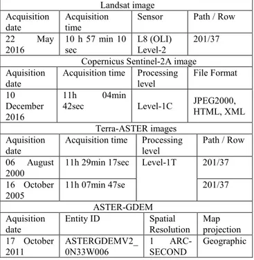
In this study we used multi-source satellite images shown in table 1, with Landsat, Terra-ASTER and ASTER-GDEM images downloaded from https://earthexplorer.usgs.gov while
sentinel-2A images were downloaded
from https://scihub.copernicus.eu). Table 1 : Satellite images used
Landsat image Acquisition
date Acquisition time Sensor Path / Row 22 May
2016 10 h 57 min 10 sec L8 (OLI) Level-2 201/37 Copernicus Sentinel-2A image Aquisition
date Acquisition time Processing level File Format 10
December 2016
11h 04min
42sec Level-1C JPEG2000, HTML, XML Terra-ASTER images
Aquisition
date Acquisition time Processing level Path / Row 06 August
2000 11h 29min 17sec Level-1T 201/37 16 October
2005 11h 07min 47se 201/37
ASTER-GDEM Aquisition
date Entity ID Spatial Resolution Map projection 17 October
2011 ASTERGDEMV2_ 0N33W006 1 ARC-SECOND Geographic These are free satellite images with high and middle spatial resolution (from 10 to 60 m). Geological maps with a 1:10,000 scale and a 1:50,000 scale, and topographic maps with a 1:50,000 scale were used to calibrate and enhance the classification of satellite images. Free open source software QGIS was used for atmospheric correction, band combination of Landsat 8 and Terra-ASTER while SNAP Desktop was used for atmospheric correction, band combination and image principale component analysis for Sentiel-2A. This Sentinel-2A was further processed and its final results were introduced into ArcGIS 10.3 for layout.
We conducted field work to take structural measurements on basalts and fractured carbonate rocks in order to validate the classification and the location of different karst landforms and fault systems extracted by remote sensing data.
A. Muzirafuti et al.
2.3 Data processing and analysis
We adopted a multidisciplinary approach combining multiple sources of data so that we could have sufficient information in our database. We started by geo-referencing topographic and geological maps which gave us a general idea of the area of study. These maps were later compared to satellite images for pixel-based classification.
2.3.1 Satellite imagery pre-processing: 2.3.1.1. Pre-processing and geo-coding:
Our area of study covers a very large surface area which implies utilization of the moisics of two scences for Sentinel-2 and one scence for Landsat 8. For Terra-ASTER we used two scenes covering Agourai and El hajeb Causses and Saiss basin. During geo-coding processing the verification of spatial resolution and geometric quality were perfomed in order to ensure the quality of our database. In the case of geometrical differences between images and maps, control ground points data acquired by Garmin GPS were used to enhance the precision.
2.3.1.2 Pre-processing and geometric adaptation of archive data:
Satellite images, geological and topographic maps were used as reference for calibration and interpretation of archive data such as google images, photographs and open street maps.
2.3.1.3 Pre-processing and atmospheric correction:
Due to the atmospheric conditions and scattered radiance saved by satellite, Dark object substraction atmospheric correction was perfomed in QGIS for Landsat 8 OLI and Terra-ASTER images while Sentinel-2 images were atmospherically corrected using Sen2Cor plugin installed in SNAP desktop.
2.3.2. Processing and land cover features extraction:
After the creation of a reliable dataset, optical and RADAR satellite images have been processed in order extract geologic and land cover information.
2.3.2.1. Processing of optical images:
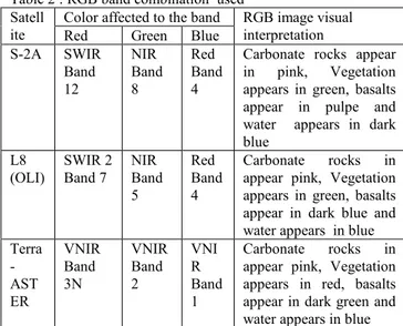
We limited the processing of Landsat 8 OLI and Terra-ASTER images on band combination, shown in table 2, technique for identification of geological formation, Rockwell, 2015, and qualitative landscape interpretation. With spatial resolution of 10 m, 20m and 60 m and spectral resolution of 13 bands, Sentinel-2A images were chosen for geologic and land cover mapping.
Table 2 : RGB band combination used Satell
ite Color affected to the band RGB image visual Red Green Blue interpretation S-2A SWIR Band 12 NIR Band 8 Red Band 4
Carbonate rocks appear in pink, Vegetation appears in green, basalts appear in pulpe and water appears in dark blue
L8
(OLI) SWIR 2 Band 7 NIR Band 5
Red Band 4
Carbonate rocks in appear pink, Vegetation appears in green, basalts appear in dark blue and water appears in blue Terra -AST ER VNIR Band 3N VNIR Band 2 VNI R Band 1 Carbonate rocks in appear pink, Vegetation appears in red, basalts appear in dark green and water appears in blue
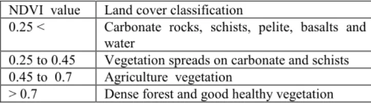
Object and pixel-based minimum distance supervised classification technique was applied to identify and locate dolomite, limestone, clay and quaternary basalts, agricultural areas, forests, built-up areas, sand quarries, and Paleozoic geological formations with overall accuracy of 96 % and kappa coefficient of 0.86. Normalized difference vegetation index , NDVI=(ρNIR-ρRED/ρNIR+ρRED) was computed to provide information on areas occupied by forest, grass, cultivated and uncultivated fields.
In SNAP desktop software, principal component analysis technique, (Loughlin, 1991), was applied on SWIR, NIR and Red bands of Sentinel-2 in order to maximize information in one band. Maximum information was observed in response band resulting from this process. Spatial profile extracted on this response band along the line interpolated on carbonate rocks showed the fluctuation of pixel values with low values on areas of eroded carbonate rocks due to the presence of gradual erosional clays (Terra-rossa) and values were observed on unaltered dolomite. Based on geologic and topographic maps, photointerpretation of changes in these values helped us to identify the continuity of curvilinear or linear structures, such as cracks, faults, fissures and fractures in dolomite and limestone. We also applied direction filter Sobel operator (with 5×5 kernel) on this response band in order to enhance the appeance of curvilinear and linear structures in Nord, South, West,and East directions. Manual digitization and classification of these structures were conducted in ArcGIS to map various fractures of fault systems identified in geological formations.
2.3.2.2. Processing of RADAR (ASTER-GDEM) images:
Advanced Spaceborne thermal Emission and Reflection Radiometer Global Digital Elevation Models (ASTER-GDEM) version 2 with 30 m spatial resolution, acquired on 17 October 2011 was processed in ArcGIS software. We started by extraction elevation information which was later compared to topographic maps to identify depressions, cliffs, valleys, volcanoes, and quarries and slope variation. Like other automatic operators, a photo-interpretation technique was used to identify and locate probable carbonate depressions.
3. RESULTS AND DISCUSSION
Lineaments extracted via satellite images revealed two main fault systems in NW-SE and NS-SW directions shown in table 3. These fractures mainly affect carbonate rocks and play an important role in the hydrogeology system of the region, where they contribute to the infiltration of surface water through the aquifer and also facilitate its movement insider the aquifer. Table 3 : Direction of main fault systems in TMA
Direction N-S E-W NE-SW NW-SE
Percentage 20 % 14 % 32 % 27 % Over one thousand karst landforms, including collapsing and subsidence sinkholes, karst depressions, lakes, pond landscapes, water springs and surface water stream flows, were identified in TMA as shown in figure 4. Their locations on main fault system affecting dolomite and limestone showed that their development is driven by tectonic processes affecting this area.
In order to validate the results obtained from satellite image processing, we conducted field works to take ground-based measurements of fractures and take GPS coordinates of some sinkholes. We took measurements on carbonate rocks and also measurements alongside water springs located in the Tabular Middle Atlas and in its area of contact with the Saiss basin. We found that a large number of sinkholes are located on the
NE-The use of remote sensing for water protection in the karst environment of the tabular middle Atlas/the causse of El Hajeb/Morocco
SW fault system, as shown in figure 4, forming a semi-circular axis, while water springs are located on the NW-SE fault system mainly in the area of contact of the TMA and Saiss basin where they are used in irrigation and for drinking water by people living in the Meknes-Fez region. Land cover information obtained from NDVI, shownin table 4, and supervised classification on sentinel-2 shows that in TMA 55 % is occupied by carbonate rocks, 25 % occupied by forest and agricultural areas, while 8 % occupied by basalts and clays. Table 4 : NDVI and land cover classification
NDVI value Land cover classification
0.25 < Carbonate rocks, schists, pelite, basalts and water
0.25 to 0.45 Vegetation spreads on carbonate and schists 0.45 to 0.7 Agriculture vegetation
> 0.7 Dense forest and good healthy vegetation Agriculture activities conducted on altered and fractured rocks especialy basalts and carbonate rocks are believed to be the origin of chemicals products observed in water springs located in the contact of TMA and Saiss basin. In addition the use of fertilizers, pesticides and herbicides for agricultural crops growth modified surface water composition and contribute to dissolution of carbonate rocks.
Figure 4: Various karst landforms in Tabular Middle Atlas.
4. CONCLUSION
This study shows the importance of remote sensing and GIS tools. The combination of satellite images and ground-based measurements provides useful information for studies conducted both in large and hard-to-reach areas. We analyzed changes in vegetation using NDVI, changes in surface water, changes in soil minerals and built-up areas using band combinations, and lineament fractures were extracted based on the variation of pixels values on the response of principal component analysis. Karst depressions were extracted manually digitized on ASTER GDEM images.
-Analysis of fractures extracted on satellite images revealed that the NE-SW fault system plays an important role in recharging TMA groundwater aquifers by facilitating the infiltration of surface water from precipitation and melting snow. Many sinkholes and karst depressions are also located along this fault system.
-NDVI and supervised classification results were validated by ground-based measurements taken during our field works and confermed the location of some collapsing and subsidence sinkholes located near agricultural areas, we also identify geological processes such as dissolution, erosion, and mylonitization affecting fractured carbonate rocks. The
dissolution of dolomite and limestone has created cavities and channels inside these rocks; these channels are the pathway for the movement of groundwater from the TMA to the Saiss basin through NW-SE fault system and can carry with this water erosion products. These products originated either from inside the rocks or from water which has infiltrated from ground surface through sinkholes located on NE-SW faults system. -The TMA is slightly pleated, creating lowlands and large depressions which people are using for farming activities. The products used to enhance the farming yield, such as fertilizers, pesticides and herbicides, can be mixed with water and change its chemistry, and when they percolate through fissures they have an effect on carbonate rocks because they dissolve them at a fast rate and gradually create underground cavities and sinkholes. In addition, during the period of high precipitation the quantity of water infiltrated becomes high and brings with it more material, leading to the change of water colour mostly observed in water springs. This turbidity affected the health of people using this water.
Human activities are having an impact on the structuration of this karst environment where the quantity of groundwater extracted for irrigation is estimated to be 25 Mm3 per year. On the other hand, ongoing climate change and over-exploitation of water have an impact on aquifer recharge zones by reducing the quantity of precipitation for infiltration and enhancing the evapotranspiration process on the surface, this has contributed to a water loss of 10 Mm3 per year, SRAT de la Région Fès Boulemane, 2013. A protection perimeter around sinkholes identified in agricultural areas is needed in order to reduce human impact on water quality at the same time taking advantage of economic activities conducted in this area.
REFERENCES
Howell, Brett A., 2016. Spring Responses to Storms and Seasonal Variations in Recharge in the Middle Atlas Region of Morocco. Theses and Dissertations—Earth and Environmental Sciences. P41, http:// Uknowledge.uky.edu/ees_etds/41 Julien Andrieu, 2018. Land cover changes on the West-African coastline from the saloum Delta (Senegal) to Rio Geba (Guinea-Bissau) between 1979 and 2015. European Journal of Remote sensing, 51:1, 314-325
Loughlin W.P., 1991. Principal component analysis for alteration mapping. Photogrametric Engineering & Remote Sensing, Vol.57, N°9, Sept 1991, pp.1163-1169.
Rockwell, B.W., Knepper, D.H., Jr., and Hothon, J.D., 2015. Landsat maps (Phase V, deliverable 60), ASTER maps (Phase V, deliverable 62), ASTER_DEM maps (Phase V, deliverable 63), and spectral remote sensing in support of PRISM-II mineral resource assessment project, Islamic republic of Mauritania (Phase V, deliverable 61 and 64).
Schéma Régional d’Aménagement du Territoire (SRAT) de la Région Fès Boulemane ,2013. Phase 1 : Diagnostic Territorial Stratégique-Etape 1 : Rapports Sectoriels, p29.
This work is licensed under a Creative Commons Attribution-No Derivatives 4.0 International License.
A. Muzirafuti et al.