Tenured researcher at the University of Florence in Urban Planning and Design, former Research Fellow in Urban Studies at the Johns’ Hopkins University. He has been a visiting scholar at UCBerkeley and at Harvard GSD. His current research focuses on suburbs, with a particular interest in international comparisons.
Ordinary Spaces and Public Life in the City of Fragments
Spazi ordinari e vita pubblica nella città di frammenti
The Urban Design Studio held in the fall 2012 within the International Curriculum in Architectural Design at the University of Florence coped with the design of peripheries. These are the least-known parts of Florence but are still the places where most of people live. Here the traditional ideas of the city and of public spaces collapse. Public life mainly shows in ordinary spaces with no particular value. The Urban Design Studio tried to discover public life in peripheries and enhance it through design
L’Urban Design Studio tenutosi nell’autunno 2012 nell’ambito dell’International Curriculum in Architectural Design all’Università di Firenze ha affrontato la progettazione delle periferie. Queste sono la parte meno conosciuta di Firenze ma sono tuttavia il luogo dove vive la maggior parte della popolazione. Qui le idee tradizionali di città e di spazio pubblico svaniscono. La vita pubblica si manifesta in luoghi ordinari privi di particolare valore. Con l’Urban Design Studio si è cercato di scoprire la vita pubblica delle periferie e di rafforzarla attraverso il progetto.
Keywords: public spaces; periphery; sprawl; urban design
I. SETTING
In the last one and a half centuries the urban population of the Florentine urban area1 tripled from about two to about six hundred thousand individuals. The growth was evenly distributed over most of the period, with higher rates in the postwar decades and a temporary reversal after 1981. In the same time the area experienced a massive urbanization, shifting from a christallerian pattern to a web of continuous linear developments containing enclosed urban voids. As in many other cities of the world the open countryside became an internal figure against the “background” of the settled area.
These major changes force us to rethink the notions with which we are used to understand the city. Several scholars studied the new settlement patterns worldwide, trying to highlight the social and economic forces which shaped them. In such analytic efforts a plethora of names and definitions, variously related to settlement patterns and to economic dynamics, was produced2. Although this naming game may appear confusing, it is now sufficiently clear that the traditional distinctions between city and country, center and periphery, natural and artificial, are becoming useless and even obstructive of our view.
This holds true also for the Florence outskirts, which appear as the landscape of fragmentation, containing various assortments of graveyards, penitentiaries, hospitals, major infrastructures, malls, parking lots, multi cinemas, gas stations, big boxes, hospitals, barracks, sports facilities, outlets, fragments of compact city, neighborhood units, linear developments; all of these intermingled everywhere with large undeveloped areas used for urban agriculture or with no apparent use. This landscape is neither rural nor urban. It’s not the dense old center of the city, where we go shopping and entertain amidst tourists, nor is it the perfect Tuscan landscape of the hills, where we relax in resorts and spas. It is the everyday living space of about one-half of the Florentines, mostly a space of little architectural value, with few squares and plazas, and with no unity of the urban form.
In such living space, away from the hordes of tourists visiting the center of Florence, apparently anonymous spaces are used for social life. Some youngsters play music at night in the parking lot of a mall. A group enjoys a beer in McDonalds’ outdoor tables, at the gas station. Others gather at the multi cinema, watch a movie, and spend some time in its ground floor pubs. Demanding palates Fig. 1 - Figure-ground representation of settlements (white) and undeveloped areas (black) in the area around Florence
stop at the coffee shop at the other gas station, which is one of the best in the area. Mothers make an appointment at the outlet, let their children with husbands at the play ground, and eat a pizza at night at the restaurant in a refurbished farmhouse nearby. Every day the ordinary spaces of the city of fragments are used by its citizens in almost infinite ways, satisfying their social and their material needs.
The 2012/2013 Urban Design Studio coped with the task of trying to grasp both the physical and the social complexity of contemporary urban suburbs of Florence, looking for ways to improve the quality of social spaces and to enhance public life.
II. COURSE THEORETICAL FRAMEWORK
Practitioners and scholars confronting with sprawl and with urban fragmentation can: a) accept it and cope with it; b) refuse it and try to recreate traditional cityscapes. Although both approaches are obviously legitimate, the traditionalist ones3 can at best apply to fragments of larger patchworks that are still complex and chaotic. They can create like oases of neghentropic order within wholes of entropic disorder.
Among the urban design practitioners who reinvented their practice in trying to cope with change, Koolaas and OMA are almost unrestrained in exploring its implications on urban design, and are as at the end of a wider spectrum of design attitudes. A younger generation of architects, from De Meulder to Viganò4, copes even more directly with the Sprawltown (Ingersoll 2006) or the Zwischenstadt (Sieverts 2002), often conceiving new forms of intermingled urbanity and rurality. It basically considers fragmentation as an opportunity for hosting new forms of everyday life and for promoting sustainability. Indeterminateness of form and uses can produce unexpected appropriations by the people, which is worthwhile discovering and taking into account before designing.
In such situations of fragmentation, the only seemingly legitimate quest for unity of urban form possibly comes from attempts of reconnecting urban voids into a web of (mostly green) areas, conceived as “wholes” which can support some social life and enhance urban environmental performances. However, since public life mostly shows up in everyday spaces, everyday urbanism (Chase, Crawford and Kaliski 2008) offers a good theoretical framework for understanding and designing peripheries.
These are amongst the most suitable approaches in trying to cope with the design of fragmented suburbs, and therefore have been largely used throughout the course.
III. STUDY AREA AND ORGANIZATION OF THE STUDIO
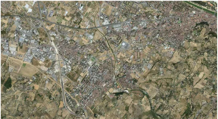
The area chosen for the Urban Design Studio which has been taught in the A.Y. 2012-13 is a South-West circular sector of the suburbs of Florence. It is an approximately wedge-shaped area bounded by two historical routes: the Via Pisana, running from the center of Florence towards Pisa, and the Via di Scandicci, a branch of the Via Pisana itself leading to Scandicci, a South-West suburb of Florence. This suburban section of Florence is bounded outwards by the A1 highway, with the exception of a mixed industrial/residential neighborhood which extends beyond it along the Via Pisana.
At the beginning of the 1980s the area has been crossed by a new thoroughfare, the Viale Nenni, in intermediate position between the two preexisting routes which had become at that time largely unsuitable to sustain high traffic volumes. On this new route a tramway was opened in 2010, connecting the Station of Firenze Santa Maria Novella with the borough of Scandicci.
The Viale Nenni has new and different features from the traditional street-corridors of the past. There are no facades fronting the street, but residential developments properly distanced and obliquely aligned to the street, several gas stations, agricultural or unused voids, a mall fronted by a wide parking lot and also obliquely aligned to the street in order to be visually noticed by drivers, the back of a big barrack, fronted by shanty buildings and almost invisible from the street. Nowadays the area shows the typical features of urban fringe-belts, with ribbon developments along the historical routes, and highly fragmented and discontinuous settlements in between.
The analysis has been extended to a neighborhood beyond the A1 highway which shows an unusual mixture of urban, rural and manufacturing uses. Although we initially considered this compound as chaotic and in utter disarray, we understood early on that it wasn’t perceived in that way by the people who lived there.
The work has been organized in three parts: a) extended survey of the area and analysis of the strategic plans developed in the last decade by coalitions of public and private actors; b) identification of action areas through the simulation of a decision-making process; c) elaboration of individual urban design projects for some of the action areas previously identified.
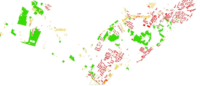
Land-use survey and stratigraphic analysis. The study area was split into five land-use survey
sections assigned to five different groups. Each land-use was matched to a layer and layers were grouped into macro-layers concerning residential buildings, working spaces, asphalt, green and social spaces. The macro-layer “asphalt”, to make an example, was formed by the layers “parking lots”, “gas stations”, “bus stations”, “public street network”, “private street network”. New groups were formed to examine in detail each macrolayer and a further group was assigned the task of synthesizing to the class the strategic objectives contained in two strategic plans developed in the
Fig. 4 - Urban agriculture and residential settlements
last fifteen years. In trying to grasp real life in the study area and getting insights about problems and needs, many interviews were conducted.
The goal of the stratigraphic analysis was to reduce the complexity of the whole to managable and intelligible strata. By analyzing the stratum ‘green’ it was possible to assess the viability of a green network which connected Scandicci to Florence, also linking the river corridors crossing and bounding the area. The analysis of the stratum ‘parking lots’ was the starting point for the development of a separate masterplan aimed at trasforming some of them into usable public spaces. The analysis of ‘schools’ crossed with the strata ‘unused green’, ‘asphalt’ and ‘public spaces’, led us to selecting a school which was highly accessible and easy to park, close to the river, and flanked by a green spot of unused land: here the design of an eco-civic park aimed at complementing and broadening school activities looked particularly recommended. Analysing and designing per strata it was possible to verify cross-sectorally the consistency between the fragments and the whole.
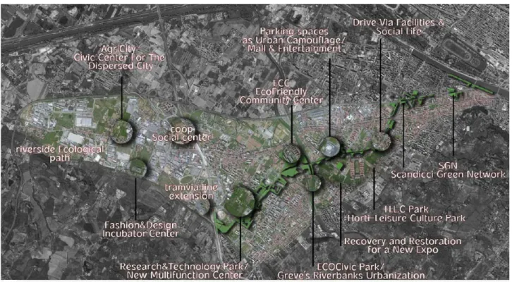
Development of a collective masterplan and of individual projects. After having taken
knowledge of the physical space and of regional strategies we started a collective process aimed at deciding which changes should be made through design. Seventeen action areas were identified. Three of them (Ecological Path Along the River Vingone, Greve Riverbanks, Scandicci Green Network) focus on the development of an integrated network of ecological corridors, equipped with bicycle and pedestrian routes. Four projects intend to improve the fashion district existing in the area, according to the guidelines of the strategic plans (Recovery and Restoration for a New Expo, Fashion&Design Incubator Center, Research and Technology Park, Education and Fashion Node). One project involves the development of an extension of the light-rail.
So far, the projects link the reading of the physical space with that of the regional socio-economic strategies, dealing in some cases with the design of public spaces. The remaining projects act more locally, envisaging public spaces specifically targeted to outskirts. Two projects focus on transforming malls from places of mere consumption to centers hosting a wider range of public and private activities (Coop Social Center, Mall&Entertainment). One project aims to turn parking lots into spaces for social life (Parking spaces as Urban Camuflage). Four projects involve the development of civic and community centers for the fragmented periphery (Horti-Leisure Culture Park, ECOCivic Park, EcoFriendly Community Center, AgriCity Civic Center for the Dispersed City). One project seeks to transform a gas station into a small centrality (Drive Via Facilities & Social Life).
IV. ORDINARY SPACES AND PUBLIC LIFE IN THE CITY OF FRAGMENTS
In peripheries public spaces have a different character than in the old city. In absence of a compact urban form public life moves from streets and squares to spaces which are not specifically thought as public places. Their distribution pattern is dispersed, for public life shows where everyday social and material needs find satisfaction: in front of schools and at children’s playgrounds, in dispersed community parishes, in malls and grocery stores, in gas stations, along riverbanks and in other open spaces which are used for sports and recreation.
The five projects, an excerpt of which is here presented, cope with some of these spaces, investigating the role of urban design today in the fragmented city of the periphery.
The Scandicci Green Network developed by Rosa Nozari and Fahimeh Vahabi is based on the layer “green”. One of the key aspects of suburbs is the abundance of open spaces. Almost each building is contiguous or at least close to some green spots of land, which are used for farming, for parks, or simply unused. This enables us to design open spaces as an integrated system of interconnected elements. Such system can be regarded as a sort of dispersed center which can be indifferently accessed from almost anywhere. It is the ‘other’ infrastructure which complements the street network. In order to make this dispersed-center, or meta-center, possible, Rosa and Fahimeh design a green corridor which stretches from the A1 highway to the Cascine Park, connecting the rivers Arno, Greve and Vingone. In times of recession, this not only enhances the environmental and ecological performances of the fragmented city as a whole, but also allows who can’t afford a car to pleasantly bike or walk to destinations.
Scandicci Green Network. Proposed masterplan.
Proposed design for the integration of the parking lot. On top right: existing condition of the parking lot.
Proposed design for the cycle track and temporary installations. On top left: existing condition of the travel lines.
Proposed design for the modification of the light rail+ bus stop On top left: existing condition of the light rail and bus stop
Camilla Carmagnini focuses on an area which is the most distant from the traditional idea of the city: a settlement where agricultural, industrial and residential uses have almost the same weight and are seemingly mixed without any criterion. This mixity of uses, however, is well perceived by inhabitants, who report satisfaction, also thanks to the existence of large green areas. In such dispersed situation a centrality still exists, made by an old country parish, and by a public school in front of it. Camilla imagines strengthening this little cluster seizing the opportunities offered by urban agriculture and proposing an Agricivic Center for the Dispersed City.
AGRICITY
ECOLOGICAL
CORRIDOR
VINGONE
PALAZZACCIO
TRANVIA
COMMERICIAL-SOCIAL USE
COOP
Transformation areas.Main features of the area.
On the right: the country parish of San Giuliano a Settimo.
Urban agriculture: a good idea? Allotments, to be rented by the inhabitants
Warehouse
Community Garden and Playground for children
Permanent multifunctional structures: Agriculture School for people and schools Farmers Market
Equipment to cook and gather
Noa Matityahou adopts a stratigraphic approach to the design of small community centers, which she calls Ecofriendly Community Centers (ECC). The basic idea is to create an isotropic but context-related infrastructure of ECCs aimed at enhancing social life and improving environmental performances. These are centers, to make some examples, where it is possible to read, connect wirelessly, take the dog for a walk, but also to collectively produce compost in small scale, sell agricultural products, and produce energy playing sports. Design is modular and elements are composed according to context.
In her project Play the parking – Reclaimed Parking Lot in Scandicci Strip, Zorica Vukovic copes with the difficult task of transforming parking lots into something which is socially livable. After having studied the layer ‘parking lots’, she establishes some design guidelines for the most significant plots. Afterwards, she focuses on a big parking lot which surrounds the Ponte a Greve Coop Mall on three sides. Instead of proposing permanent transformations which might affect the functionality of the whole, she suggests to use some parts of it for temporary events.
SCANDICCI CENTER FIRENZE CENTER ALDO MORO STREET
Parking play project.
open green area
parkour and skate pool path / entrance into the zone front side bike paths existing commercial center
street leading around the island existing part of the island / renewed
path / entrance into the zone back side
open green area
The last project is the Research and Technology Park which Georgios Tryantafillidis proposes to settle between the residential and industrial tissues of Scandicci. This is thought as a place “where industry and city meet”. The proposal is an attempt to create “a gentle transition from the production to consumerism and vice-versa. A production that is not only material, but is also production of ideas, technology, innovation, culture and education, interaction.” It is also an attempt to create a new public space where it is possible to participate to the trial and development of new technologies.
ACKNOWLEDGMENT
I wish to give special thanks to Margaret Crawford for her invaluable suggestions and comments about the course organization.
NOTES
[1] This area has been identified as a local economic system and includes the municipalities of Firenze, Bagno a Ripoli, Calenzano, Campi Bisenzio, Fiesole, Lastra a Signa, Scandicci, Sesto Fiorentino, Signa. Cfr. Irpet and Regione Toscana, eds., Il mosaico territoriale dello sviluppo socio-economico della Toscana [Regional mosaic of socio-economic development in Tuscany], Firenze, Regione Toscana, 2001.
[2] A complete list would take too long. These are just some examples: informational city (Castells 1989), edge city (Garreau 1991), global region (Sadler 1992), technopolis (Scott 1993), post-suburbia (Teaford 1997), reverse city (Viganò 1999), exopolis (Soja 1996), post-metropolis (Soja 2000), edgeless city (Lang 2003), Zwischestadt (Sieverts 2003), metropolitan archipelago (Indovina 2009).
[3] For a review of the major neo-traditionalist approaches on the European continent and in the Anglo-Amer-ican tradition, see Ellin N., 1999, “Neorationalism”, and “Neotraditional urbanism or the new urbanism”, in Postmodern Urbanism, Princeton Architectural Press, N.Y., pp. 23-37, 93-113.
[4] Various design approaches to dispersed and fragmented settlements are presented in: Segal R., Verbakel E., eds., “Cities of Dispersal”, AD Architectural Design 78(1), Wiley, 2008.
REFERENCES
Castells, Manuel (1989), The Informational City: Information Technology, Economic Restructuring and the
Urban-Regional Process, Blackwell, Oxford.
Chase, John, Crawford, Margaret and Kaliski, John (eds., 2008), Everyday Urbanism, Monacelli Press, New York.
Ellin, Nan (1999), Postmodern Urbanism, Princeton Architectural Press, New York. Garreau, Joel (1991), Edge City. Life on the New Frontier, Doubleday, New York.
Indovina, Francesco (2009), Dalla città diffusa all’arcipelago metropolitano, FrancoAngeli, Milano.
Ingersoll, Richard (2006), Sprawltown. Looking for the City on its Edges, Princeton Architectural Press, New York.
Irpet and Regione Toscana (eds., 2001), Il mosaico territoriale dello sviluppo socio-economico della Toscana, Regione Toscana, Firenze.
Koolhaas, Rem (1994), S,M,L,XL, Monacelli Press, New York.
Lang, Robert E. (2003), Edgeless Cities: Exploring the Elusive Metropolis, Brookings Institution Press, Wash-ington, D.C.
Sadler, David (1992), The Global Region: Production, State Policies, and Uneven Development, Pergamon Press, New York.
Scott, Allen John (1993), Technopolis : High-Technology Industry and Regional Development in Southern
Cali-fornia Berkeley, University of CaliCali-fornia Press, Berkeley.
Segal Rafi and Verbakel Els (eds., 2008), “Cities of Dispersal”, AD Architectural Design, 78(1), Wiley. Sieverts, Thomas (2003), Cities Without Cities: an Interpretation of the Zwischenstadt, Spon Press, London. Soja, Edward W. (1996), Thirdspace: Journeys to Los Angeles and Other Real-and-Imagined Places, Black-well, Cambridge, Mass.
Soja, Edward W. (2000), Postmetropolis: Critical Studies of Cities and Regions, Blackwell, Malden, Mass. Teaford, Jon C. (1997), Post-Suburbia : Government and Politics in the Edge Cities, Johns Hopkins University Press, Baltimore.