Alma Mater Studiorum
Alma Mater Studiorum –– Università di Bologna
Università di Bologna
DOTTORATO DI RICERCA IN SCIENZE DELLA TERRA
Ciclo XXII
Settore scientifico-disciplinare di afferenza: GEO 02
TITOLO TESI
Thermochronologic and geodynamic evolution of the Pontides: Sakarya
terrane (Karakaya Complex) and İstanbul terrane, Turkey.
Presentata da: Dr.ssa Ilaria Federici
Coordinatore Dottorato Relatore
Prof. Roberto Barbieri Prof. Massimiliano Zattin
ACKNOWLEDGEMENTS
I thank Professors Massimiliano Zattin and William Cavazza of Department of Earth and Geoenvironmental Sciences of the University of Bologna, for their support and suggestions during all the course of this study.
I am grateful to Professor Aral Okay of the Eurasia Institute of Earth Sciences, Istanbul Technical University (Turkey) for his helpfulness during the field trip in Turkey and for his comments and suggestions during the review of the manuscripts that are part of this thesis. I am greatly in debt to Dr. Olivier Beyssac of the Institut de Minéralogie et de Physique des Milieux Condensés CNRS-Paris (France), for the kind hospitality in his lab, for all the time spent on my training and for his comments to the manuscript.
I am also very grateful to Dr.ssa Sveva Corrado of Department of Geological Sciences of University of “Roma Tre” for the hospitality in her lab and mainly for her precious comments and ideas during the draft of the manuscript.
I express my gratitude to Dr Francesco Dellisanti of Department of Earth and Geoenvironmental Sciences of the University of Bologna, for his fruitful discussions that enriched my knowledge of clay minerals analysis and for his contribution to the manuscript.
I deeply appreciate Professor Gian Gaspare Zuffa of Department of Earth and Geoenvironmental Sciences of the University of Bologna, and Dr Fabio Tateo of the Department of Geosciences of University of Padua for their careful review of the thesis. A friendly tanks goes to Selvihan Goktak that accompanied me during the field trip in Turkey.
I am very grateful to my family and friends that support and encourage me during all the course of this study. Finally, last but not least, a special thanks goes to Riccardo.
CONTENTS
ABSTRACT RIASSUNTO
CHAPTER 1 – 1.1 Introduction
1.2 Methodology
CHAPTER 2 – Thermal evolution of the Permo-Triassic Karakaya
subduction-accretion complex from the Biga Peninsula to the Tokat Massif (Anatolia)
CHAPTER 3 – Pre-Cenozoic amalgamation of the İstanbul and Sakarya terranes (NW Turkey) – evidence from low-temperature thermochronology
CHAPTER 4 – A precursor of the North Anatolian Fault in the Marmara Sea region CHAPTER 5 – Conclusion
REFERENCES
APPENDIX 1 – Clay mineralogy
APPENDIX 2 – Vitrinite reflectance (Ro%)
APPENDIX 3 – Raman spectroscopy on carbonaceous material (RSCM) APPENDIX 4 – Apatite fission track (AFT) analysis
ABSTRACT
An integrated array of analytical methods -including clay mineralogy, vitrinite reflectance, Raman spectroscopy on carbonaceous material, and apatite fission-track analysis- was employed to constrain the thermal and thermochronological evolution of selected portions of the Pontides of northern Turkey.
(1) A multimethod investigation was applied for the first time to characterise the thermal history of the Karakaya Complex, a Permo-Triassic subduction-accretion complex cropping out throughout the Sakarya Zone. The results indicate two different thermal regimes: the Lower Karakaya Complex (Nilüfer Unit) -mostly made of metabasite and marble- suffered peak temperatures of 300-500°C (greenschist facies); the Upper Karakaya Complex (Hodul and the Orhanlar Units) –mostly made of greywacke and arkose- yielded heterogeneous peak temperatures (125-376°C), possibly the result of different degree of involvement of the units in the complex dynamic processes of the accretionary wedge. Contrary to common belief, the results of this study indicate that the entire Karakaya Complex suffered metamorphic conditions. Moreover, a good degree of correlation among the results of these methods demonstrate that Raman spectroscopy on carbonaceous material can be applied successfully to temperature ranges of 200-330°C, thus extending the application of this method from higher grade metamorphic contexts to lower grade metamorphic conditions.
(2) Apatite fission-track analysis was applied to the Sakarya and the İstanbul Zones in order to constrain the exhumation history and timing of amalgamation of these two exotic terranes. AFT ages from the İstanbul and Sakarya terranes recorded three distinct episodes of exhumation related to the complex tectonic evolution of the Pontides. (i) Paleocene - early Eocene ages (62.3-50.3 Ma) reflect the closure of the İzmir-Ankara ocean and the ensuing collision between the Sakarya terrane and the Anatolide-Tauride Block. (ii) Late Eocene - earliest Oligocene (43.5-32.3 Ma) ages reflect renewed tectonic activity along the İzmir-Ankara. (iii) Late Oligocene- Early Miocene ages reflect the onset and development of the northern Aegean extension. The consistency of
AFT ages, both north and south of the tectonic contact between the İstanbul and Sakarya terranes, suggest that such terranes were amalgamated in pre-Cenozoic times.
(3) Fission-track analysis was also applied to rock samples from the Marmara region, in an attempt to constrain the inception and development of the North Anatolian Fault system in the region. The results agree with those from the central Pontides. The youngest AFT ages (Late Oligocene - early Miocene) were recorded in the western portion of the Marmara Sea region and reflect the onset and development of northern Aegean extension. Fission-track data from the eastern Marmara Sea region indicate rapid Early Eocene exhumation induced by the development of the İzmir-Ankara orogenic wedge. Thermochronological data along the trace of the Ganos Fault –a segment of the North Anatolian Fault system- indicate the presence of a tectonic discontinuity active by Late Oligocene time, i.e. well before the arrival of the North Anatolian Fault system in the area. The integration of thermochronologic data with preexisting structural data point to the existence of a system of major E-W-trending structural discontinuities active at least from the Late Oligocene. In the Early Pliocene, inception of the present-day North Anatolian Fault system in the Marmara region occurred by reactivation of these older tectonic structures.
RIASSUNTO
Una serie di metodologie analitiche (mineralogia delle argille, riflettenza della vitrinite, spettroscopia Raman sulla materia organica, analisi delle tracce di fissione in apatite) è stata applicata per determinare l’evoluzione termica e termocronologica di alcuni vasti settori delle Pontidi (Turchia settentrionale).
(1) Per la prima volta è stato utilizzato un metodo integrato dei parametri temperatura- dipendenti per la caratterizzazione termica del Complesso di Karakaya, un complesso di subduzione-accrezione permo-triassico, che affiora estesamente in tutta la Zona di Sakarya. I risultati ottenuti hanno messo in evidenza due diverse storie termiche per tale complesso. La porzione inferiore del Complesso (Unità di Nilüfer) – costituita prevalentemente da metabasiti e marmi- è caratterizzata da un intervallo di temperature massime compreso tra 300-500°C, indicando condizioni metamorfiche nel campo degli scisti verdi. La porzione superiore del Complesso (Unità di Hodul e Orhanlar) – costituita prevalentemente da grovacche e arcose- ha registrato un intervallo di temperature massime molto ampio (120-376°C) dovuto al diverso grado di coinvolgimento delle unità nei complessi processi dinamici del prisma di accrezione. I risultati di questo studio indicano che anche tutta la porzione superiore del Complesso di Karakaya ha subito condizioni metamorfiche, contrariamente a quanto riportato in letteratura. Le tre metodologie applicate (mineralogia delle argille, riflettenza della vitrinite, spettroscopia Raman sulla materia organica) hanno mostrato un buon grado di correlazione, permettendo così di applicare la spettroscopia Raman sulla materia organica anche a temperature comprese tra 200°C e 330°C. L’applicazione di tale metodo a condizioni di basso grado metamorfico risulta quindi molto promettente.
(2) Le analisi termocronologiche (studio delle tracce di fissione in apatiti) sono state applicate alle Zone di İstanbul e di Sakarya, al fine di ricostruire la storia di esumazione e vincolare la tempistica dell’amalgamazione di questi due terreni esotici. I dati termocronologici provenienti dalle Zone di İstanbul e di Sakarya hanno registrato tre distinti episodi di esumazione legati alla complessa evoluzione delle Pontidi. (i) Le età di esumazione del Paleocene-Eocene inferiore (62.3-50.3 Ma) sono associate alla
chiusura dell’oceano İzmir-Ankara e alla risultante collisione tra la Zona di Sakarya a nord e il blocco anatolide-tauride a sud. (ii) Le età eocenico superiori - oligocenico inferiori (43.5-32.3 Ma) sono collegate ad una successiva fase deformativa lungo la sutura İzmir-Ankara, come anche indicato da deformazione e iati sedimentari nei bacini interni. (iii) Un terzo gruppo coerente di età (Oligocene superiore – Miocene inferiore) nella parte più occidentale dell’area di studio testimonia l’inizio dell’estensione egea. L’uniformità delle età di esumazione riscontrate in entrambe le zone (İstanbul e Sakarya) indica che la collisione tra questi due frammenti continentali è avvenuta durante il Mesozoico, cioè prima degli eventi deformativi registrati dalle tracce di fissione.
(3) L’analisi delle tracce di fissione è stato applicato anche a campioni provenienti dalla regione del Mare di Marmara, per caratterizzare l’evoluzione del ramo occidentale della Faglia Nord-Anatolica. I risultati sono in accordo con quelli provenienti dalle Pontidi centrali. Nei settori più occidentali si riscontrano le età di esumazione più recenti legate all’estensione egea; mentre i settori più orientali registrano una rapida esumazione nell’Eocene inferiore derivante dalla strutturazione dell’orogene di İzmir-Ankara. I dati ottenuti lungo la Faglia di Ganos – un segmento del sistema di faglia nord-anatolico- mettono in evidenza la presenza di una discontinuità tettonica attiva già dall’Oligocene superiore, ben prima della nucleazione della Faglia Nord-Anatolica ad est. L’integrazione dei dati termocronologici con quelli strutturali pre-esistenti su tutta la regione del Mare di Marmara suggerisce l’esistenza di un sistema di discontinuità tettoniche orientate E-O attive almeno dall’Oligocene superiore, lungo le quali, a partire dal Pliocene inferiore, si è impostato l’attuale sistema di faglia nord-anatolico.
CHAPTER 1
1.1 Introduction
Turkey occupies a crucial position in the geodynamic evolution of the Tethyan domain and particularly in the Eastern Mediterranean region. The present-day geological setting of Turkey (Fig. 1) is the result of complex geodynamic processes that involved the Tethyan domain during Paleozoic and Mesozoic time. Turkey is made of numerous continental fragments (also called terranes) that during the evolution of the Paleotethys and Neotethys rifted off from either sides of these two oceanic domains and eventually collided with the opposite continental margins (e.g. Okay & Tüysüz 1999; Stampfli & Hochard 2009). The final amalgamation of these terranes occurred in Late Tertiary time when the Arabian plate collided with the Eurasian plate (Okay & Tüysüz 1999).
Geologically, Turkey can be divided into three main tectonic units: the Pontides, the Anatolide-Tauride Block and the Arabian platform (Okay 2008). The Pontides (Fig. 1), that comprise the Strandja Massif, the İstanbul and the Sakarya Zones (or terranes), show Laurasian stratigraphic affinities whereas the Anatolide –Tauride Block and the Arabian platform are tectonically and stratigraphically related to Gondwana (Şengör & Yılmaz 1981; Okay et al. 1996; Okay & Tüysüz 1999).
This dissertation is focused on different aspects of the geological evolution of the Pontides of northern Turkey.
The Pontides, a composite orogene stretching >1,500 km from eastern Bulgaria to the Lesser Caucasus, from late Paleozoic to Recent times, have suffered the cumulative effects of a complex structural history, including the Variscan (Carboniferous), Cimmerian (Triassic), and Alpine (Late Cretaceous-Paleocene) orogenies (Yılmaz et al. 1997; Tüysüz 1999) as well as Aegean extension and significant strike-slip deformation associated with the North Anatolian Fault system (for a review, see Stephenson et al. 2004).
In this complex geodynamic setting, a multidisciplinary methods has been applied to investigate the thermochronological and geodynamic evolution of selected elements of the Pontides. In details the main goals of the dissertation may be summarised as follow:
(i) the thermal evolution of the Karakaya Complex, a Permo-Triassic Paleotethyan subduction-accretion complex cropping out throughout the Sakarya terrane (Chapter 2); (ii) the exhumation history of the İstanbul and Sakarya exotic terranes (Chapter 3); (iii) the tectonic evolution of the western North Anatolian Fault in the Marmara Sea region (Chapter 4).
i) The Karakaya Complex is the tectonostratigraphic term used to designate the strongly deformed Permo-Triassic rock units in the Sakarya terrane of northern Anatolia (Figure 2). This complex developed during Permo-Triassic northward subduction of the Paleotethys along the southern margin of Eurasia (Tekeli 1981; Pickett and Robertson 1996; Okay 2000; Stampfli & Borel 2004).
The Karakaya Complex was studied by many authors since 1975 when Bingöl et al. defined for the first time this complex. In the following years many interpretations about the origin and the stratigraphy of the Karakaya Complex were made (Tekeli 1981;
Akyürek & Soysal 1983; Akyürek et al. 1984; Şengör et al. 1984; Koçyiğit 1987; Kaya et al. 1989; Okay et al. 1991; Altıner & Koçyiğit 1993; Pickett & Robertson 1996; Y. Yılmaz et al. 1997; Göncüoğlu et al. 2000). Up to now two geodynamic models are still in competition to explain the evolution of the Karakaya Complex and more in general to explain the evolution of this complex in the western Tethyan (Paleo-Tethyan) domain: the rift model (Bingöl et al. 1975) and the subduction-accretion one (Tekeli 1981), each of them with many different variations (Y. Yılmaz 1981; Şengör & Yılmaz 1981; Şengör 1984; Şengör et al. 1984 Koçyiğit 1987; Genç & Yılmaz 1995; Göncüoğlu et al. 2000; Pickett et al. 1995; Pickett & Robertson 1996; Okay 2000).
Generally two tectono-stratigraphic units were defined in the Karakaya Complex: the first one, made up of metabasites, phyllites and marble, and the second one, made up of highly deformed clastic and volcaniclastic rocks which generally are considered non metamorphosed or slightly metamorphosed (e.g. Pickett 1994)
In this contribution I have used, for the first time, an integrated analytical methods for determination of organic and inorganic temperature-dependent parameters to characterise the thermal structure and evolution of the Karakaya Complex.
More in detail, these methods include clay mineral parameters, such as the Kübler Index and the percentage of illite in I-S mixed layers, vitrinite reflectance (Ro%) and Raman spectroscopy on carbonaceous material (RSCM).
Clay mineral parameters and vitrinite reflectance are traditionally used to constrain thermal conditions from diagenesis (Corrado et al. 2005; Aldega et al. 2007a, b) to epizone (Ferreiro Mählmann 2001; Rantitsch et al. 2005; Potel et al. 2006; Judik et al. 2008); on the other hand, Raman spectroscopy (RSCM) was applied to provide reliable estimates of peak metamorphic temperatures in the range 330°-650°C (Beyssac et al. 2002a,b, 2003, 2004, 2007; Rantitsch et al. 2004). More recent studies focussed on lower temperature ranges (Lahfid 2008), and now a good qualitative approach is also available to estimate temperature <330°C (Lahfid 2008). In this work I have applied the Raman spectroscopy on carbonaceous material also to low grade metamorphic conditions (200-330°C) to test the reliability of this technique in this temperature range. ii) The Intra-Pontide suture is the boundary between the İstanbul and the Sakarya terranes. This boundary is considered by Okay and Tüysüz (1999) the result of the progressive closure of an Intra-Pontide ocean during the Senonian. In contrast, according to Şengör and Yılmaz (1985), the Intra-Pontide suture formed in the early Eocene after an orthogonal opening between İstanbul and Sakarya terranes during the Liassic. Stampfli and Hochard (2009) support a middle Jurassic collision between İstanbul and Sakarya terranes. Akbayram et al. (2009) favour a Cenomanian collision.
In this geological context apatite fission-track (AFT) analysis has been used to constrain the exhumation history of the İstanbul and Sakarya terranes.
Fission-track dating is a powerful tool to infer the time of uplift and exhumation of the rocks and to give a measure of their motion toward the Earth’s surface. The large number of samples collected from both terranes (İstanbul and Sakarya) isolate three discrete episodes of exhumation related to the complex tectonic evolution of the Pontides. These results have significant bearings on paleogeographic-paleotectonic reconstructions of the eastern Mediterranean region.
iii) The Neogene tectonics in the Marmara region is the result of interaction between the Aegean extension regime and the westward escape of the Anatolian microplate guided by the North Anatolian Fault (NAF) (Fig. 3). In the Aegean region, the rigid westward translation of the Anatolian microplate combined with back-arc spreading behind the Aegean Trench gave way to distributed north-south extension along E-W–trending normal faults. This extension resulted in the formation of E-W trending grabens, which
are the most prominent neotectonic feature of western Anatolia (Bozkurt, 2001). The same structural trend is observed in the Marmara Sea region, where the NAF developed as a complex fault system.
Following the work of Zattin et al. (2005) that deals with the activity of the NAF in the southwestern Thrace Basin, new apatite fission-track (AFT) data, have been integrated with (U-Th)/He ages and preexisting structural data (Aksoy, 1998; Okay et al., 2008) to characterise the tectonic evolution of the western segment of the North Anatolian Fault (NAF) in the Marmara Sea region.
Due to the different objectives dealt with in this study, associated with the vast dimensions of the study area, this dissertation is written as a collection of three papers (Chapter 2, 3, and 4) focused on the single goals outlined above. In the final chapter (Chapter 5) the main results are summarized and integrated in a broader geodynamic context.
Figura 3. Simplified tectonic map of the Marmara region showing the North Anatolian Fault system. Modified from Okay et al., 2008.
1.2 Methodology
To investigate the thermal and thermochronological evolution of selected elements of the Pontides I have used a multidisciplinary approach including clay mineralogy, vitrinite reflectance and Raman spectroscopy on carbonaceous material for the thermal characterization of the Karakaya Complex, and apatite fission track analysis to constrain the exhumation history of the İstanbul and the Sakarya terranes, and the tectonic evolution of the western segment of the North Anatolian Fault (NAF) in the Marmara Sea region.
Because of the complicated nature of the Karakaya Complex such a multidisciplinary (integrated) approach has more chance to give a coherent result than the use of a single one.
In the sections below a concise description of these methodologies are given. 1.2.1 Clay mineralogy
Prograde clay mineral transformations in a sedimentary basins are primarily a response to burial and varying degrees of tectonic fabric development at temperatures below 300°C. Some transformations produce predictable patterns of change in mineral assemblage that can be used to characterised the conditions of diagenesis and very low grade-metamorphism in basins (Merriman, 2005). These patterns involve the smectite-illite-to-muscovite transformation that is part of a more extended series of reactions in 2:1 dioctahedral clay minerals. The series of reactions: smectite → mixed-layer illite/smectite (I/S) →illite → muscovite is characterised by a progressive increase in crystal thickness (illite “crystallinity”) and decrease in defect densities, lattice strain and compositional variability as illite-muscovite becomes better ordered (Peacor, 1992)
The most common method now used for determining grade in metapelitic sequences is the Kübler Index of illite “crystallinity”, which measures changes in the shape of the first basal reflection of dioctahedral illite-muscovite at an X-ray diffraction (XRD) spacing of approximately 10 Å. This method is a good tool to determine the thermal maturity in sediments in a range between the deep diagenetic zone to the epizone (Merriman & Peacor, 1999). Another important measurement is the quantification of mixed-layer illite/smectite (I/S). Measurement of proportions and degree of ordering in the smectite-/I/S-illite reaction series is the most widely used indicator of reaction progress in the diagenetic zone (Merriman, 2005).
Progress in the trioctahedral 2:1 reaction series can be also monitored using the Árkai Index of chlorite “crystallinity” (Árkai 1991; Guggenheim et al. 2002).
1.2.2. Vitrinite Reflectance
Vitrinite Reflectance is the most widely used indicator of thermal maturity in sedimentary rocks containing organic particles. Vitrinite is a maceral family of humic coals derived from the decay of ligno-cellulose parts of higher plants (Durand et al., 1987). With increasing temperature and pressure within the Earth’s crust, irreversible chemical reactions take place within the vitrinite structure. This process, termed maturation or coalification, include chemical transformation such as decarboxylation, dehydroxylation, demethylation, aromatization, and finally polycondensation of aromatic lamellae (Mukhopadhyay, 1994). The major physical manifestation of the maturation process is the increase in the reflectance of vitrinite. The reflectance of vitrinite is defined as the proportion of normal incident light reflected by a plane polished surface of vitrinite, which changes according to the level of maturation (Mukhopadhyay, 1994). This thermal maturity indicator is an effective method for estimating the maximum temperatures experienced from sedimentary rocks in the diagenetic zone.
1.2.3 Raman Spectroscopy on carbonaceous material
The Raman Spectroscopy on Carbonaceous Material (RSCM) is a new geothermometer and can be applied to metasedimentary rocks to indicate the peak of the metamorphic condition.
During diagenesis and metamorphism, carbonaceous material present in the initial sedimentary rock progressively transforms into graphite (graphitization). The corresponding progressive evolution of degree of organization of the carbonaceous material is considered to be a reliable indicator of metamorphic grade, especially of temperature (Beyssac et al., 2002a).
Because of the irreversible character of graphitization, the carbonaceous material structure is not sensitive to retrograde metamorphism and therefore primarily depends
on the maximum temperature reached during metamorphism, whatever the retrograde history of the sample (Beyssac et al.,2002b). It also has been observed that samples collected from neighbouring outcrops with clearly different strain have the same degree of graphitization, indicating that deformation does not significantly affect the structural organization of the carbonaceous material (Beyssac et al.,2002b).
Now this technique is successfully applied in the range of high grade metamorphism (T between 350°C to 650°C) (Beyssac et al. 2002a,b, 2003, 2004, 2007; Rantitsch et al. 2004). Recently, Lahfid (PhD thesis 2008) focused his study to lower the range of temperature investigation. And now there is a good qualitative approach to estimate temperature values from Raman analysis. In this work I have applied the Raman spectroscopy on carbonaceous material also to low grade metamorphic conditions (200-330°C) to contribute to lower the temperature range of this new methodology.
1.2.4. Correlation of methodologies
Such multi-method investigation shows a good degree of correlation among the obtained results (widely described in chapter 2). Reliability of data is therefore increased because each methodology investigates different parameters, organic and inorganic, and each in a different range of temperature. Moreover these results demonstrate that Raman spectroscopy on carbonaceous material can be applied successfully to temperature ranges of 200-350°C, thus extending the application of this method from higher grade metamorphic contexts (Bollinger et al. 2004; Beyssac et al. 2007; Gabalda et al. 2009) to lower grade metamorphic conditions.
1.2.5. Fission tracks in apatite
Thermochronology is a technique that permits the extraction of information about the thermal history of rocks. Because temperature increases with depth in the Earth’s lithosphere, this temperature information can be translated into structural information, thermochronological data contain a record of the depth below the surface at which rocks
resided for a given time. This methodology is able to constrain quantitatively the time of rock exhumation towards the surface (Braun et al., 2006).
Fission track dating method is based on the spontaneous fission of 238U which cause a structural damage in the crystal lattice. This technique is no different from other isotopic dating methods based on the decay of a naturally radioactive parent to a stable daughter atom. In the fission track method it is the spontaneous fission tracks instead of daughter isotopes that are measured as a product of the decay of 238U (Wagner & Van Den Haute, 1992).
Experimental study on minerals (Fleischer et al., 1965) showed that temperature is the most important parameter that influence the stability of fission tracks in minerals. The damage zone comprising a fission track in the crystal lattice is not stable and tend to be repaired with the increase of temperature by a process called annealing. This process is gradual and the temperature range at which tracks density and their length decrease is known as Partial Annealing Zone (PAZ) (Wagner & Van Den Haute, 1992). In fission track dating, the cooling range in the PAZ have to be “adapted” in a single temperature value, to which the age has to be referred; this temperature value is defined by Dodson (1973) as the closure temperature(Tc). Wagner and Reimer (1972) suggest that the closure temperature correspond to a temperature within the PAZ, where about 50% of the tracks are stable.
For apatite the PAZ spam from about 60°C to 120°C and the Tc is about 110°C ±
10°C
Apatite fission track analysis is a powerful tool to determine the time of deformation and the crustal depth at which it took place.
CHAPTER 2
This chapter consists of the manuscript titled “Thermal evolution of the Permo-Triassic Karakaya subduction-accretion complex from the Biga Peninsula to the Tokat Massif (Anatolia)” by Ilaria Federici, William Cavazza, Aral I. Okay, Olivier Beyssac, Massimiliano Zattin, Sveva Corrado and Francesco Dellisanti. The manuscript was submitted to the “Turkish Journal of Earth Sciences” on October 27th, 2009.
Thermal evolution of the Permo‐Triassic Karakaya subduction‐accretion
complex from the Biga Peninsula to the Tokat Massif (Anatolia)
ILARIA FEDERICI1, WILLIAM CAVAZZA1, ARAL I. OKAY2, OLIVIER BEYSSAC3,
MASSIMILIANOZATTIN4, SVEVA CORRADO5 & FRANCESCO DELLISANTI1
1Department of Earth and Geoenvironmental Sciences, University of Bologna (Italy)
2Eurasia Institute of Earth Sciences, Istanbul Technical University (Turkey) 3IMPMC, UMR 7590 CNRS-Paris 6-Paris 7-IPGP, Paris (France)
4Department of Geosciences, University of Padua (Italy) 5Department of Geological Sciences, University Rome3, (Italy)
Abstract
The results of the combined application of a series of analytical methods (clay mineralogy, vitrinite reflectance, Raman microspectroscopy) placed tight constraints on the thermal evolution of the Karakaya Complex of northern Anatolia, a mostly Permo-Triassic subduction-accretion complex resulting from the progressive closure of the Paleotethys. The thermal evolution of the Karakaya Complex is the result of Permian-Triassic subduction-accretion processes, and was not significantly affected by later Alpine-age tectonism, as shown by Liassic shallow-water siliciclastic and carbonate deposits unconformably overlying the Karakaya Complex which did not undergo any significant
burial. The Lower Karakaya Complex –made of metabasite and subordinate marble and phyllite- experienced maximum temperatures ranging from 340 to 497°C, in agreement with independently determined thermobarometric reconstructions. The entire Upper Karakaya Complex –previously considered either unmetamorphosed or slightly metamorphosed - was affected by zeolite to lower greenschist facies metamorphism (120-376°C). The coherent results of this study show that Raman microspectroscopy has great potential for the determination of relatively low paleotemperatures (200-350°C).
Key Words: vitrinite reflectance, clay mineralogy, Raman microspectroscopy,
metamorphism, Pontides
Introduction
Karakaya Complex is the tectonostratigraphic term used to designate the strongly deformed Permo-Triassic rock units in the Sakarya terrane (Sakarya Composite Terrane of Göncüoğlu et al. 1997; also known as Sakarya Zone) of northern Anatolia (Figure 1). This complex developed during Permo-Triassic northward subduction of the Paleotethys along the southern margin of Eurasia (Tekeli 1981; Pickett and Robertson 1996; Okay 2000; Stampfli & Borel 2004).
Although the pre-Jurassic rocks of the Sakarya terrane have been described and mapped by several authors in previous years, the comprehensive term Karakaya Formation was first defined by Bingöl et al. (1975), who supported an intracontinental rift origin for
this unit. Conversely, Tekeli (1981) proposed a subduction-accretion origin. The Karakaya Formation was renamed Karakaya Complex by Şengör et al. (1984). Several other studies have dealt with the Karakaya Complex (e.g. Akyürek & Soysal1983; Akyürek et al. 1984; Koçyiğit 1987; Kaya et al. 1989; Okay et al. 1991; Altıner & Koçyiğit 1993; Pickett & Robertson 1996; Göncüoğlu et al. 2000, 2004; Okay & Altıner 2004, Yılmaz & Yılmaz 2004) yet the same two geodynamic interpretations are still in competition: the rift model and the subduction-accretion one, each with several different variations (Yılmaz 1981; Şengör & Yılmaz 1981; Şengör 1984; Şengör et al. 1984 Koçyiğit 1987; Genç & Yılmaz 1995; Göncüoğlu et al. 2000; Pickett et al. 1995; Pickett & Robertson 1996, 2004; Okay 2000).
There is general agreement that the Karakaya Complex is restricted to the Sakarya terrane of the Pontides and is absent in the rest of the Pontides and in the Anatolide-Tauride Block (Okay & Göncüoğlu 2004) (Figures 1, 3). Two tectonostratigraphic units were defined in the Karakaya Complex: the first one made of metabasite, phyllite and marble, the second one made of highly deformed epiclastic and volcaniclastic rocks considered unmetamorphosed or slightly metamorphosed (e.g. Pickett 1994). Following Okay & Göncüoğlu (2004), the terms Lower and Upper Karakaya Complex are used here for the metabasite series and the clastic series, respectively.
In this contribution we determine in the Lower and Upper Karakaya Complex (i) clay mineral metamorphism by XRD diffraction-derived parameters such as the Kübler Index and the percentage of illite in I-S mixed layers, and (ii) organic metamorphism by means of vitrinite reflectance data and Raman spectroscopy on carbonaceous material (RSCM). These temperature-dependant parameters have been successfully applied to constrain the thermal structures of high crustal levels of better known regions where very low- to low-grade metamorphic rocks are exposed (e.g. Beyssac et al. 2004; Potel et al.
2006; Judik et al. 2008). Clay mineral parameters such as the Kübler Index and the percentage of illite in I-S mixed layers coupled with vitrinite reflectance are traditionally used to constrain thermal conditions from diagenesis to epizone (Ferreiro Mählmann 2001; Rantitsch et al. 2005; Potel et al. 2006), and their correlations have been widely explored both in diagenetic (Corrado et al., 2005; Aldega et al. 2007a, b) and metamorphic conditions (Potel et al. 2006). Raman spectroscopy has been applied widely to provide reliable estimates of peak metamorphic temperatures between 350° and 650°C (Beyssac et al. 2002, 2003, 2004, 2007; Rantitsch et al. 2004); a pilot study focused on temperature below 350°C (Lahfid 2008).
Geological setting
The study area is located in the Sakarya terrane, an east-west-trending continental block about 1,500 km long and 120 km wide (Figure 1). To the northwest the Sakarya terrane is in tectonic contact with the İstanbul terrane by means of the Intra-Pontide suture, and to the north it is bounded by the Black Sea. The contact with the Anatolide-Tauride Block to the south is marked by the Izmir-Ankara-Erzincan suture. Outcrops of the Permo-Triassic, highly deformed, low-grade metamorphic rocks of the Karakaya Complex characterize the Sakarya terrane over a distance of ca. 1,100 km from the Biga Peninsula to the Lesser Caucasus. The Sakarya terrane, together with the İstanbul and Strandja terranes, has Laurasian affinity (Okay & Tüysüz 1999) with Paleozoic and Mesozoic stratigraphies different from the Anatolide-Tauride Block to the south. These terranes were amalgamated into a single continental unit during the latest Cretaceous-Paleocene continental collision (Şengör & Yılmaz 1981; Okay & Tüysüz 1999).
The Karakaya Complex is subdivided in a low-grade metamorphic series [Lower Karakaya Complex (LKC), also known as Nilüfer Unit] and a clastic series [Upper Karakaya Complex (UKC)] made of highly deformed epiclastic and volcaniclastic rocks (Hodul, Orhanlar and Çal Units) (Figure 2).
The LKC consists of highly deformed and metamorphosed metabasite, phyllite and marble, with minor amounts of metachert, metagabbro and serpentinite (Okay & Göncüoğlu 2004). Rocks of the LKC are generally foliated, isoclinally folded and cut by a large number of shear zones. The original thickness is difficult to estimate but the structural thickness exceeds 5 km (Okay & Göncüoğlu 2004). Conodonts from marble interbedded with the metabasite gave an Early Triassic age from the type locality of the LKC south of Bursa and a Middle Triassic age from the Biga peninsula (Kaya & Mostler 1992; Kozur et al. 2000).
The LKC is metamorphosed in greenschist facies, with a common mineral paragenesis of actinolite/barroisite + albite + chlorite + epidote in the metabasite (Okay & Moniè 1997; Okay 2000; Okay et al. 2002). Locally metamorphism reaches albite-epidote amphibolite, blueschist, and eclogite facies (Okay & Moniè 1997; Okay et al. 2002; Okay & Göncüoğlu 2004). The blueschist and eclogite facies rocks form tectonic slices within the predominantly greenschist facies rocks. Ar-Ar isotopic ages from phengite and amphibole from an eclogite lens enclosed into the greenschist facies east of Bandırma (Okay & Monié 1997) and from blueschist and high-pressure greenschist facies metabasite north of Eskişehir (Okay et al. 2002) yielded very similar Late Triassic (205-203 Ma) ages. The LKC of the eastern Pontides yielded early Permian (263-260 Ma) Ar-Ar and Rb-Sr ages (Topuz et al. 2004a, b).
The relationship between the LKC and the epiclastic and volcaniclastic rocks of the UKC are almost everywhere tectonic. The UKC consists of three tectonostratigraphic units
made of highly deformed epiclastic and volcaniclastic rocks (Figure 2). The highly deformed nature of these units make their identification and correlation across the Sakarya terrane problematic (Okay & Göncüoğlu 2004). However, there is a general agreement –at least in the western outcrop area- on the fact that the UKC includes a thick series of quartzo-feldspathic sandstone-shale (Hodul Unit) with a continental granitic source, and a greywacke-shale sequence (Orhanlar Unit). The UKC also comprises a series of basalt, debris flows and grain flows with Upper Permian limestone clasts (Çal Unit) (Okay et al. 1991; Pickett & Robertson 1996; Okay & Göncüoğlu 2004). In this paper, we extend tentatively this stratigraphic subdivision to our entire study area. Outside of their type localities in the area of the Biga peninsula, the terms Hodul Unit and Orhanlar Unit as used in this study refer generically to arkosic sandstones and graywackes, respectively, belonging to the upper structural levels of the Karakaya Complex (for a description, see below). Currently, a rigorous tectonostratigraphic correlation throughout the entire outcrop area of the Karakaya Complex is hampered by the high degree of structural complexity combined with the scarcity of detailed regional studies.
From west to east, the Hodul Unit crops out from the Biga Peninsula to the region north of Eskişehir, and consists of arkosic sandstones with intercalation of shales and siltstones, which pass upward into debris flows with blocks of basalt and Carboniferous and Permian limestone (Okay et al. 1991; Leven & Okay 1996). Arkosic sandstone ranges from coarse-grained, thickly bedded proximal facies with pebbles of granite to finer-grained distal turbidites. The arkosic sandstone succession is attributed to the Norian, mainly based on a few occurrences of Halobia sp. (Kaya et al. 1986; Wiedmann et al. 1992; Leven & Okay 1996; Okay & Altiner 2004). The presence of Ladinian limestone blocks in the Bursa area (Wiedmann et al. 1992) may indicate a longer time span for the Hodul Unit.
The Hodul Unit is strongly deformed with anastomosing shear zones and boudinage obscuring original bedding at all scales, from outcrop to thin section. The estimated total thickness of this unit is >2 km (Okay 2000), a more precise determination being hampered by the high degree of deformation. The Hodul Unit is unconformably overlain by fairly undeformed shallow-water Liassic sandstone and siltstone (Bayırköy Formation, Fig. 2).
The bulk of the Orhanlar Unit (>80%) is made up of yellowish green, yellowish brown, highly fractured and generally altered greywacke that rarely shows recognizable bedding (Okay et al. 1991). These rocks are composed of very poorly sorted angular quartz, plagioclase, opaque minerals, black metachert, red radiolarian chert, basalt and phyllite clasts set in an argillaceous matrix. In the locality type near the Orhanlar village, the greywacke series contains small (<1m) olistoliths of dark Lower Carboniferous (Visean and Serpukhovian) limestone and is overlain by undeformed Liassic sandstones and siltstones (Leven & Okay 1996). The Orhanlar Unit shows strong layer-parallel extension that has destroyed much of the original bedding. However, its thickness ranges probably from a few hundred meters to over 1 km. Okay et al. (1991) describe the origin of the Orhanlar as related to an accretionary complex.
The Çal Unit (Figure 2) consists mainly of grain and debris flows with basalt and Upper Permian limestone clasts. The siliciclastic mass flows are interbedded with basaltic lava flows, calciturbidites, pelagic limestone, shale, greywacke and rare radiolarian chert (Okay et al. 1991; Pickett & Robertson 1996). A typical feature of this unit is the presence of fossiliferous Upper Permian limestone blocks and olistoliths ranging in size from a few centimeters to one kilometer. The debris-flow deposits are distinguished from those of the Hodul Unit by the abundant presence of spilitized basic volcanic rocks (Sayıt & Göncüoğlu 2009). The Çal Unit is also strongly deformed, and hence the stratigraphic relationships of this unit, if any, with the other units of the UKC are obscure.
The tectonic evolution of the Karakaya Complex is still matter of debate. In the rift model proposed by Bingöl et al. (1975) and then developed by Şengör & Yılmaz (1981), Şengör et al. (1984), Şengör (1984), Genç & Yılmaz (1995), and Göncüoğlu (2000), the Karakaya Complex was deposited in a Late Permian rift, which developed in a small marginal basin and closed in the Late Triassic by southward subduction. Initially Bingöl et al. (1975) assumed that the Karakaya rift was purely intracontinental, but the presence of oceanic crustal lithologies in the Karakaya Complex led to the suggestion that the Karakaya rift developed into a oceanic marginal basin (Şengör & Yılmaz 1981). In this model, it is assumed that the Karakaya marginal basin opened on the northern margin of the Anatolide-Tauride Block above the southward subducting Palaeotethys ocean and that the Permian and Carboniferous limestone blocks are derived from uplifted rift shoulders.
The subduction-accretion model was firstly proposed by Tekeli (1981) and then developed by Pickett et al. (1995), Pickett & Robertson (1996), and Okay (2000). This model assumes that the Karakaya Complex was formed during the Late Permian-Triassic by northward subduction-accretion of the Paleotethys under the active Laurasian margin. The units of the Karakaya Complex were formed either during the steady-state subduction of oceanic crust or during subduction of oceanic seamounts (Pickett & Robertson 2004) or oceanic plateau (Okay 2000).
Sampling
Samples were collected from suitable rock types over a distance of about 800 km from the Biga peninsula to the Tokat Massif (Figures 1, 3). Samples from the Biga Peninsula, Bandırma, and Bursa are from the type areas of the Karakaya Complex. The remaining samples come from the Ankara area, the Tokat Massif, and the Kargı Massif, where the
lithological assemblage has been correlated to the Karakaya Complex of Biga, Bandırma, and Bursa (Yılmaz & Yılmaz 2004; Okay 2000; Okay & Göncüoğlu, 2004; Pickett & Robertson 2004).
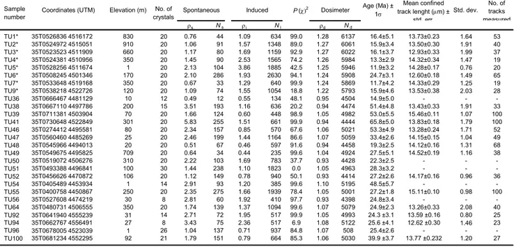
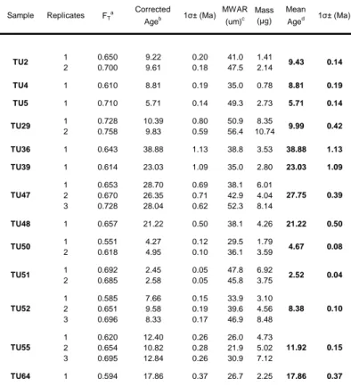
Twenty samples for clay mineralogy analysis were collected mainly from clay and silt layers of the Hodul and Orhanlar Units of the UKC. Only two samples were taken from the phyllite of the LKC. Twelve samples for vitrinite reflectance analysis were collected in the same localities mainly from the arenaceous and pelitic beds of the Hodul and Orhanlar Units. Seventeen samples were collected in the same localities for Raman spectroscopy (RSCM) from both the Upper (Hodul and Orhanlar Units) and Lower Karakaya Complex. The results of these analyses are reported in Tables 1 and 2.
Methods
Clay mineralogy
Mineralogical composition of the bulk rock and clay fraction was carried out by powder X ray diffraction (XRD) using a Philips PW 1710 diffractometer (CuKα radiation, 40kV/30 mA power supply, graphite secondary monochromator, 1° divergence and scatter slits, 0.1 mm receiving slit, 0.02° 2q step size, counting time of 2 s/step).
Clay mineralogy was determined on <2mm grain-size fraction by XRD. Following the recommendations by Kisch (1991), the <2mm fraction was obtained by differential settling after disintegration by shaking in demineralized water and ultrasonic disaggregation for up to 15 minutes. Both air-dried and ethylene glycol solvated samples (50°C overnight) were analyzed by XRD. Smeared oriented mounts were prepared for each sample taking into account that the amount of clay on the glass slide was at least 3mg/cm2 (Lezzerini et al. 1995). Mineralogical parameters were determined via processing of the
XRD patterns by WINFIT program (Krumm 1996) using an asymmetrical Pearson VII function (Stern et al. 1991; Warr & Rice 1994). The semiquantitative modal composition of the clay fraction was calculated using the method by Biscaye (1965) slightly modified to take into account the occurrence of mixed layer illite-smectite (I-S) and chlorite-smectite (C-S).
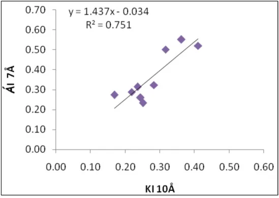
The very low-grade metamorphism was estimated on air-dried samples by using the illite Kübler Index (KI) obtained by measuring the full-width-at-half-maximum-height (D°2q) on the (001) illite diffraction peak at about 10 Å (Kübler 1967; Guggenheim et al. 2002). KI data were calibrated against the CIS scale (Warr & Rice 1994) using the following regression equation: KI(CIS) = 1.09 KI(Bologna) + 0.02 (R2 = 0.96) (Dellisanti et al.
2008). Chlorite crystallinity was determined on air-dried samples using the Árkai Index (AI) (Árkai 1991) obtained measuring the full-width-at-half-maximum-height (D°2q) on the (002) chlorite diffraction peak at about 7 Å (Árkai 1991; Guggenheim et al. 2002). AI data were calibrated using the equation: AI(CIS) = 1.13 AI(Bologna) - 0.02 (R2 = 0.84)
(Dellisanti et al. 2008). The occurrence of mixed layers I-S and C-S was determined on glycolated samples applying the NEWMOD computer modelling (Reynolds 1985; Moore & Reynolds 1997).
Vitrinite Reflectance (Ro%)
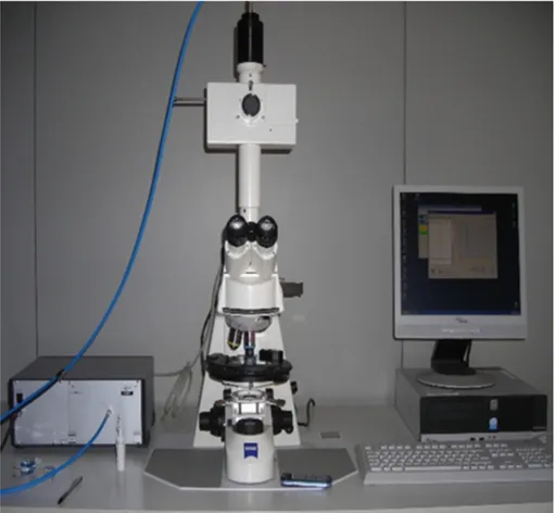
Whole-rock samples were mounted on epoxy resin and polished according to standard procedures described in Bustin et al. (1990). Random reflectance (Ro%) was measured under oil immersion, with a Zeiss Axioplan microscope in reflected monochromatic non-polarized light. For each sample, an average of 20 measurements were taken on vitrinite fragments >5µm and only slightly fractured. Mean reflectance and standard deviation values were then calculated.
Raman Spectroscopy on Carbonaceous Material (RSCM)
RSCM thermometry is based on the quantitative study of the degree of graphitization of carbonaceous material (CM) which is a reliable indicator of metamorphic T. Because of the irreversible character of graphitization, CM structure is not sensitive to the retrograde path during exhumation of rocks and depends on the maximum T reached during metamorphism (Beyssac et al., 2002). T can be determined in the range 330-650°C with a precision of ± 50 °C due to uncertainties on petrologic data used for the calibration. Relative uncertainties on T are however much smaller, probably around 10-15 °C (Beyssac et al. 2004).
Raman spectra were obtained using a Renishaw InVIA Reflex microspectrometer (Ecole Normale Superieure, Paris). We used a 514 nm Spectra Physics argon laser in circular polarization. The laser was focused on the sample by a DMLM Leica microscope with a 100× objective (NA=0.90). The laser power at the sample surface was set at 1 mW. Rayleigh diffusion was eliminated by edge filters, and the entrance slit was closed down to 10-15 µm to achieve nearly confocal configuration. The signal was finally dispersed using a 1800 gr/mm grating and analyzed by a Peltier cooled RENCAM CCD detector. Before each session, the spectrometer was calibrated with a silicon standard. Because Raman spectroscopy of CM can be affected by several analytical mismatches, we followed closely the analytical and fitting procedures described by Beyssac et al. (2002, 2003). Measurements were taken on polished thin sections cut perpendicularly to the main fabrics (S0, S1) and CM was systematically analyzed below a transparent adjacent mineral,
generally quartz. 10-15 spectra were recorded for each sample in the extended scanning mode (1000-2000 cm-1) with acquisition times from 30 to 60 s. Spectra were then processed using the Peakfit software (Beyssac et al. 2003).
Lahfid (2008) investigated the applicability of RSCM thermometry at lower temperatures, based on a qualitative comparison with reference spectra from the Glarus Alps of Switzerland. Although elaboration of the definitive version of the quantitative calibration is still in progress, we used a qualitative comparison with the reference spectra to determine temperature values in low-grade rocks.
Results
Clay mineralogy
Mineralogical data of clay fraction are reported in Table 1 and Figure 3. The <2µm fraction is dominated by illite and chlorite, with subordinate mixed layer illite-smectite (I-S) and chlorite-smectite (C-S) present only in a few samples. Overall, the Hodul Unit is characterized by the predominance of illite with respect to chlorite whereas the Orhanlar Unit has similar percentages of illite and chlorite. The LKC (Nilüfer Unit) has a mineralogical composition similar to the Orhanlar Unit with a slight enrichment in illite content.
The illite Kübler index (KI) is used to evaluate the metamorphic grade. KI values of 0.42 and 0.25 (D°2q) are considered as lower and higher boundaries of the anchizone (Merriman & Frey 1999; Merriman 2005; Kübler 1967), whereas the value of 0.30 (D°2q) is defined as the boundary between lower and upper anchizone. The Árkai index is correlated with the Kübler index, and the values of 0.33 and 0.26 are established as deep diagenetic zone - anchizone and anchizone – epizone boundaries, respectively (Árkai 1991).
KI values in analyzed samples range between 0.95 and 0.19, i.e. from deep diagenesis to epizone (Merriman & Frey 1999). In the Biga Peninsula KI data from the
pelitic layers of the Hodul Unit range from 0.95 to 0.86 (D°2q), indicating deep diagenetic conditions (samples IF24 and IF 19; Table 1, Figure 3). These data agree with the presence of highly ordered mixed layers illite-smectite (I-S) with illite content of about 80% and 90% respectively (Table 1) due to an incomplete illitization reaction. KI values from the Hodul Unit in the Bandırma area range narrowly between 0.26 and 0.19, indicating high anchizone/epizone conditions.
Samples from the Bursa area belong to the Hodul Unit to the NE and to the Orhanlar Unit SW of the city (Table 1). The Hodul Unit experienced deep diagenetic conditions (sample IF7; KI = 0.92; 85% illite in I-S) whereas the Orhanlar Unit yielded contrasting results, ranging from deep diagenetic conditions (sample IF 39; KI = 0.52; 95% illite in I-S) to high anchizone – epizone (IF36 and IF37; KI = 0.23 and 0.26, respectively). In the Inegöl area about 60 km SE of Bursa sample TU224 from a pelitic horizon of the Hodul Unit yielded a KI value of 0.31, at the boundary between low and high anchizone (Table 1).
Southwest of Ankara high anchizone conditions prevail in the Orhanlar Unit (TU 229 and TU231; KI = 0.27 and 0.26) whereas east of Ankara the same unit suffered only deep diagenetic conditions (TU233 and TU235; KI = 0.50) (Figure 3). For both the Bursa and the Ankara regions, there is general agreement between KI values and Árkai Index (AI) values from samples of the Orhanlar Unit (Table 1).
In the Tokat Massif KI values from the Orhanlar Unit and the LKC range from 0.32 to 0.27 (TU 237, TU 241, TU242) indicating the boundary between low and high anchizone for both units. KI data agree with Árkai Index (AI) data (Table 1).
In the Kargı Massif one sample (TU244) was collected from the LKC. The KI value of 0.31 indicates the boundary between low and high anchizone. Again KI and Árkai Index (AI) are in agreement.
Vitrinite Reflectance (Ro%)
Kerogen is generally abundant, heterogeneous, and mainly made of poorly preserved macerals. When recognizable, macerals mainly belong to the vitrinite and inertinite groups. Where vitrinite is present, the lower Ro% measurements are representative of indigenous woody fragments and are characterized by a gaussian distribution, whereas the higher Ro% values show a less regular distribution and are mostly made up of altered or recycled fragments. Pyrite, either finely dispersed or in small globular aggregates, is generally present around vitrinite fragments. Overall, Ro% mean values cover a wide range between 0.74 and 3.85%, i.e. from the mid-mature stage of hydrocarbon generation in the deep diagenetic zone to high (i.e. deep) anchizone.
In more detail, in the Biga peninsula (Figure 3) Ro% data from the arkosic sandstones of the Hodul Unit (IF23, IF17, IF20) cluster between 0.74 and 0.97% (Table 1), indicating the beginning of the deep diagenetic zone. Pelites from the same unit (IF24, IF19) yielded higher Ro% values of 1.37 and 1.98. Ro% frequency distribution of sample IF 24 is strongly unimodal and indicates a probably indigenous population of vitrinite fragments; conversely the frequency distribution of sample IF19 is rather scattered and indicates considerable reworking. In summary, the Hodul Unit experienced a thermal evolution from middle to very mature stages of hydrocarbon generation (oil and wet gas) in deep diagenetic conditions. The only sample taken from the Orhanlar Unit in the Biga
peninsula (IF13) yielded an Ro% value of 1.03, in general agreement with the samples from the Hodul Unit within the same area.
In the Bandırma area reliable Ro% data were obtained only from sample IF33 (Hodul Unit) with values indicating anchizone conditions (Ro%=3.3).
Northeast of Bursa sample IF7 from the pelites of the Hodul Unit is characterized by abundant reworked material; nevertheless the Ro% value of the possible indigenous population is 1.17%, indicating the deep diagenetic zone. Southwest of Bursa two samples from the greywackes of the Orhanlar Unit were analyzed (Table 1). IF39 has a mean Ro% of about 1.7% in the deep diagenetic zone for a possible indigenous population, but with abundant reworked vitrinite fragments. IF 36 yielded much higher values (mean Ro of about 3.1%) correlatable with the middle anchizone.
In the Tokat area, Ro% data from greywackes of the Orhanlar Unit range between 3.6% and 3.8%, indicating high anchizone conditions.
Raman spectroscopy on carbonaceous material (RSCM)
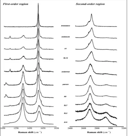
Raman spectroscopy-derived temperatures of analyzed samples range between 270°C and 497°C. Samples which yielded temperatures <350°C and >350°C are listed in Tables 1 and 2, respectively. Representative Raman spectra and corresponding RSCM temperatures for samples with temperatures >350°C are shown in Figure 4.
Samples from the Hodul Unit in the Bandırma area (IF28, IF29, IF31, IF33, IF34) (Figure 3) recorded temperatures <300°C. As mentioned earlier, in this case temperature estimates are based on a semiquantitative approach and the result is a homogeneous value
of 270°C±30°C for all samples. These values suggest that in this area the Hodul Unit has undergone very low-grade metamorphic conditions.
In the Bursa area, samples 7249, 7370, 7369 were taken from the LKC phyllite and marble. Sample 7369 yielded a temperature of 405°C whereas for samples 7249 and 7370 temperature estimates reach 340°C±30°C.
In the area south of Inegöl and North of Eskişehir, peak metamorphic temperatures are 376°C (TU224 from the Hodul Unit) and 497°C (TU226 from a marble layer of the LKC) respectively.
RSCM data from the Orhanlar Unit in the Ankara area show an increase in temperatures from northeast (TU233 and TU235; <230°C and 270°C±30°C, respectively) to southwest (TU229; 372°C).
In the Tokat Massif two samples were collected. South of the massif, sample TU237 from the Orhanlar Unit yielded a temperature of 270°C±30°C; in the northern part of the massif sample TU243 from the LKC yielded temperature of 459°C.
Discussion
The results of this research, integrated with preexisting petrological data (Genç & Yılmaz 1995; Okay & Monié 1997; Yılmaz et al. 1997; Yılmaz & Yılmaz 2004; Okay et al. 2002, 2006), provide a comprehensive thermal characterization of the Karakaya Complex of northern Anatolia. In Figure 5 the paleotemperatures obtained from clay mineralogy, vitrinite reflectance, and Raman microspectroscopy are summarized. Overall, two main thermal conditions could be recognized: a deep diagenetic condition in the Biga peninsula to the west and a much higher thermal condition -from low anchizone to epizone- to the
east. Some of the samples taken southwest of Bursa and northeast of Ankara seem to contradict this general pattern.
Okay (1991, fig.13) depicts the Orhanlar Unit in the Biga peninsula regionally thrust over the Hodul Unit. A later (probably late Tertiary) near vertical fault downdropped the Orhanlar Unit and juxtaposed it to the Hodul Unit. We found no substantial difference between hangingwall and footwall thermal maturity indicating that their thermal signature has been acquired in an almost homogeneous shallow environment (deep diagenetic environment; 4-5 km of depth) in a range of 125°-140°C, probably after both thrusting and later high-angle faulting. The lack of a well developed cleavage in the mudstones indicates a negligible illite recrystallization during diagenetic processes, confirming low burial depths and temperatures. Apatite fission-track data acquired on the same units (Cavazza et al. 2009) indicate temperatures higher than 125°C (total resetting).
In the Bandırma area (Figure 3), Ro, KI, and RSCM data from the Hodul Unit indicate anchizone-epizone conditions suggesting that the thermal signature was acquired in a much deeper environment (8-9 Km) with respect to the same unit in the Biga peninsula (Figure 5). In this locality, the Hodul Unit tectonically overlies the LKC (Nilüfer Unit). Okay & Monié (1997) described for the LKC in this area a >5 km thick succession, mainly made of metabasite metamorphosed in greenschist facies with actinolite or barroisite + albite + epidote + chlorite + titanite. Within the metabasite, a tectonic lens of eclogite occurs and its mineral paragenesis indicates high pressure-low temperature metamorphism, whereas the metabasite show no evidence of high pressure metamorphism. Geochronological data (40Ar/39Ar) from the eclogite gave an age for the metamorphic peak
between 208 and 203 Ma (Triassic-Jurassic boundary) (Okay & Monié 1997). The radiometric age is consistent with stratigraphic data as Liassic deposits unconformably overlain the metamorphic rocks.
Northeast of Bursa vitrinite reflectance and clay mineralogy data from the Hodul Unit (Figures 3 and 5) indicate deep diagenetic conditions suggesting a thermal path with no substantial differences from that of the same unit in the Biga peninsula. Southwest of Bursa the LKC is characterized by high-pressure greenschist facies metamorphism with a mineral assemblage of actinolite/barroisite + epidote + chlorite + albite + leucoxene; within the green metabasite there is an epidote blueschist band with mineral assemblage of quartz + sodic amphibole + epidote + albite (Okay 2004). As there is no evidence for polymetamorphism in these rocks, it could be the result of cogenetic metamorphism in the P-T region of transition between blueschist and greenschist facies (Okay 2004). Kisch et al. (2006) provides mean b0 data of 9.039 Å from the same unit and suggests a
metamorphic condition characterized by intermediate to high pressure in a convergent basin setting with low geothermal gradient (Merriman 2005). RSCM and b0 data are in
agreement with petrological data described by Okay (2004) indicating a low-grade metamorphic condition for the LKC in this area. Our data provide further constraints as RSCM temperatures from the phyllite and marble of the LKC range between 340°C±30°C and 405°C (Table 1).
In the same area the Orhanlar Unit underwent peak temperatures from deep diagenesis to high anchizone/epizone (Figure 5), corresponding to a burial depth from 5-6 to 9-10 km. The progressive change in thermal conditions is confirmed by a different development of microfabric and bulk mineralogy of mudstones samples (Kisch 1987; Merriman & Frey 1999). Mudstones in diagenetic conditions show a bedding-parallel fabric, whereas high anchizone and epizone conditions are characterized by slaty cleavage and increased illite-muscovite/quartz ratios due to recrystallization of strongly oriented illite and muscovite (Norris & Rupke 1986). These estimates are in agreement with temperatures obtained by RSCM (340°C±30°C).
Moving to the east, KI data from the Hodul Unit in the Inegöl area (Figure 3) indicate the boundary between low and high anchizone. Temperature obtained by RSCM (376°C) recorded a slightly higher thermal condition but compatible with the KI value. In this area, the arkosic sandstone of the Hodul Unit is thrust over the LKC (Genç & Yılmaz 1995). A wedge shaped tectonic slice of metaophiolite, consisting of metamorphosed serpentinite, gabbro and basalt, is also present in this area (Genç & Yılmaz 1995).
In the area north of Eskişehir, eclogite and blueschist facies rocks occur as a thrust sheet within the greenschist facies of the LKC. The common blueschist facies mineral assemblage in the metabasite is sodic-amphibole epidote + albite + chlorite + phengite ± garnet. Eclogite paragenesis of garnet + sodic pyroxene + sodic-calcic amphibole + epidote has been found only in one locality (Okay et al. 2002). P-T conditions of the epidote-blueschist facies metamorphism are estimated at 450±50°C and 11-12 kbar, whereas the very low Na contents of calcic amphiboles in the greenschist facies metabasites indicate pressure <4 kbar (Okay et al. 2002). RSCM data (497°C) from a marble layer within the metabasites of the LKC are in agreement with petrological data. Again, phengite, sodic amphibole, and barroisite 40Ar/39Ar ages from metabasite range between 215-205 Ma and indicate Late Triassic high pressure metamorphism, similarly to what was found in the Bandırma eclogite (Okay et al. 2002).
In the Ankara region, samples from the Orhanlar Unit record two somehow different thermal evolutions (Figure 3 and 5). KI and RSCM data from samples TU 229 and TU 231 indicate paleotemperatures typical of the high anchizone and the top of the epizone. On the other hand, KI data from samples TU233 and TU235 indicate only deep diagenetic conditions. The different thermal paths observed in the Ankara region could derive from tectonic deformation. In fact, samples indicating high anchizone and epizone conditions show a closely spaced slaty cleavage due to recrystallization and orientation of
platy mineral, mostly illite-muscovite, as a consequence of the progressive burial at temperatures of about 200-300°C. By contrast, the samples with higher KI value show a spaced scaly cleavage typical of tectonic shear. Shear strain can induce lattice defects in the illite structure leading to estimate higher KI values (Árkai et al. 2002; Abad et al. 2003) and consequently to apparent lower thermal conditions. Thus, the samples could have had the same thermal history but different subsequent tectonic evolution, as also shown by the higher RSCM temperatures obtained from the tectonically deformed samples.
In the Tokat Massif, the LKC was affected by regional metamorphism in greenschist facies as the mineral paragenesis suggests pressures of 3 to 6 kbar and temperatures of 300-500°C (Rojay & Göncüoğlu 1997; Yılmaz et al. 1997; Yılmaz & Yılmaz 2004). Our RSCM paleotemperature determinations (380-459°C) from the LKC fit well with the preexisting thermobarometric reconstructions (Figures 3 and 5). KI, Ro, and RSCM paleotemperature determinations from the Orhanlar Unit indicate homogeneous thermal conditions at about 270-300°C.
In the Kargı Massif, our results from the LKC (Figure 3 & 5) are in agreement with the low-grade regional metamorphism in high pressure greenschist facies shown by Okay et al. (2006).
In summary, moving eastward (Figure 5) the Hodul Unit recorded peak thermal conditions from diagenesis (Biga peninsula) to anchizone and epizone (Bandırma and Inegöl). This increase in thermal conditions is interrupted northeast of Bursa, where the Hodul Unit records only deep diagenetic conditions. Similar geographic trends are present in the Orhanlar Unit. In fact, data from organic and inorganic parameters for this unit range from deep diagenetic condition in the Biga peninsula to anchizone and epizone around Bursa, Ankara, and in the Tokat Massif. This coherent geographic trend is somehow interrupted in the Ankara region, where deep diagenetic and low anchizone conditions
were recorded. Data from the LKC are fully concordant with those preexisting thermobarometric reconstructions and peak temperatures determined during this study are everywhere higher than those from the Upper Karakaya Complex. KI data indicate high anchizone conditions and RSCM temperatures (ranging between 340±30°C to 497°C) along with petrological data indicate greenschist facies metamorphism. The highest peak temperature metamorphism detected here is from Bursa, Eskişehir and in the Tokat Massif areas.
The integrated dataset (clay mineralogy, vitrinite reflectance, Raman microspectroscopy) obtained during this study is in agreement with clay mineralogy data recently obtained from the Karakaya Complex by Tetiker et al. (2009a, b). For example, Tetiker et al. (2009b, Fig. 12) report KI values from the UKC in the area between Edremit and Bursa ranging from 0.85 and 0.30. Our average KI value from the same region is 0.62 ± 0.33, if we exclude the results obtained from samples taken around Bandırma –an area not sampled by Tetiker at al. (2009b). Similarly, KI values obtained by Tetiker at al. (2009b, Fig. 6) from the Tokat Massif cluster at 0.15-0.30 for the LKC and 0.25-0.40 for the UKC, again in agreement with our data (Table 1). Reconstructed peak thermobarometric conditions (Tetiker et al. 2009a, Fig. 8; 2009b, Fig. 17) of 14 Kb/500 °C for the LKC and 5 Kb/300° C for the UKC are in agreement with our temperature reconstructions constrained by multiple methods.
The results of this study and the preexisting data available in the literature are still insufficient to fully discriminate among the various hypotheses put forward to explain the development of the Karakaya Complex. For the LKC a wealth of data on textural features, mineral associations, clay/phyllosilicate transformations, typical index minerals, and crystallochemistry of various mineral species points to HP/LT conditions in a compressional basin (Okay & Moniè 1997; Rojay & Göncüoğlu 1997; Okay et al. 2002;