SCUOLA DOTTORALE IN GEOLOGIA DELL’AMBIENTE E DELLE
RISORSE
DOTTORATO DI RICERCA IN GEOLOGIA DELLE RISORSE
NATURALI
CICLO DEL CORSO DI DOTTORATO XXVII
Exploration of medium- and low-enthalpy geothermal resources in the
sub-Andean area for the sustainable development of the cities of the
Salta province (northwestern Argentina)
ROBERTA MAFFUCCI
Nome e Cognome del dottorando
firma
SVEVA CORRADO
Docente Guida/Tutor: Prof.
firma
GUIDO GIORDANO
Co-Tutor: Prof.
firma
SABINA BIGI
Co-Tutor: Prof.
firmaCLAUDIO FACCENNA
ACKNOWLEDGEMENTS
This dissertation would not have been possible without the guidance and the help of some close people who accompanied me during the years of this research project.
First of all, I would like to express my deeply gratitude to my supervisor Prof. Sveva Corrado for her constant guidance, support, enthusiasm and inspiration that allowed me to develop this project.
I am extremely grateful to my co-supervisor Prof. Sabina Bigi. She accompanied me step by step in these years. I thank her for the continuous help, teaching and for the confidence she put in me to undertake the PhD project.
I am also indebted to my co-supervisor Prof. Guido Giordano. His teachings and comments highly enhanced this Thesis.
My sincere gratitude goes to Dr. Lea Di Paolo for her precious help in the field and for her support and scientific contribution.
Thanks to Prof. Chiara Invernizzi and Prof. Pietropaolo Pierantoni for their precious help in the field and for the useful discussions. They have contributed significantly to the results presented in Chapter 6 of this Thesis.
I would also like to thank Prof. Josè Viramonte, Dr. Agostina Chiodi and Dr. Walter Baez for their scientific contribution and also for their help during the fieldwork and their warm hospitality in Argentina.
Thanks to the company Geotermia Andina that provided the inspiration for this project. Thanks to Dr. Carlo Ungarelli for the useful discussions on the integration with audiomagnetotelluric data presented in the Chapter 6.
Thanks to Dr. Luca Aldega and Dr. Chiara Caricchi for their encouragement and for the discussions on the burial and exhumation history results of the stratigraphic succession involved in the Sierra de La Candelaria anticline.
Thanks are also due to Prof. Stefano Mazzoli and Prof. Massimiliano Barchi who provided stimulating and helpful reviews of my Thesis.
I am indebted to my many colleagues with whom I shared the office or who I met in these years at Roma Tre: Marco, Gabriele, Francesco, Silvia, Andrea, Gabriele, Andrea, Luca, Massimo, Ileana, Ines, Giorgia, Sandro, Danilo, and Lorenzo.
Thanks also to all the people who I met in Argentina. They made a travel job an amazing life experience: Mama Julia y su hermosa familia, Florencia, Tato, Nesth, Emilce, Gabriela, Raul and Rodriguez.
Thanks also to my dear friends Raffaella, Chiara, Marco, Eloisa, Roberta.
Many thanks to my relatives, parents and sister for their love, and in particular, to my mother and my mother-in-law. Without their extraordinary help, this work would not have been finalized.
Finally, special thanks to my husband and my son. They are the reason of my life and to them, I would like to dedicate this Thesis.
TABLE OF CONTENTS
ABSTRACT iv
RIASSUNTO viii
CHAPTER I - INTRODUCTION 1
1.1 Problem 1
1.2 Aims of the thesis and methodology 2
1.3 Outline of the Thesis 4
CHAPTER II - PREVIOUS STUDIES AND OPEN PROBLEMS 6
2.1 Introduction 6
2.2 Geodynamic framework 8
2.2.1 The Central Andes 8
2.2.2 The Santa Barbara System 9
2.2.3 The Metán basin 12
2.3 Sierra de La Candelaria anticline 14
2.4 Rosario de La Frontera geothermal system 17
CHAPTER III - TECTONIC MODEL OF SIERRA DE LA CANDELARIA
ANTICLINE 22
3.1 Introduction 22
3.2 Structural analysis at the outcrop scale 22
3.2.1 Southwestern Backlimb 24
3.2.2 Northeast nose of Balboa anticline 26
3.2.3 Northern nose of Termas anticline 28
3.2.3.1 Backlimb 29
3.2.3.2 Periclinal closure area 30
3.2.3.3 Forelimb 33
3.3 Structural setting of the Sierra de La Candelaria 33
3.4 Tectonic interpretation of the deformation sequence 35
CHAPTER IV - 3-D MODEL OF THE RESERVOIR AND FRACTURE
MODELLING 40
4.1 Introduction 40
4.2 Methodology 40
4.3 Lithological components of the geothermal system 43
4.4 3-D reservoir model 45
4.5 Reservoir discrete fracture network model 46
4.5.1 Fracture data elaboration 47
4.5.1.1 Type and orientation 48
4.5.1.2 Intensity 50
4.5.1.3 Size (height, length and aperture) 53
4.5.2 Problems in data modelling 54
4.5.3 Results 56
4.6 DFN upscaling 57
4.7 Geothermal potential 59
CHAPTER V - EVALUATION OF THE CAP-ROCK EFFECTIVENESS 62
5.1 Introduction 62
5.2 Methods and materials 62
5.2.1 Optical study of organic matter dispersed in sediments for thermal evolution of
sedimentary basins 63
5.2.1.1 Generalities 63
5.2.1.2 Thermal maturity parameters used in this Thesis 66
5.2.1.2.1 Vitrinite Reflectance 66
Sample preparation and analysis 68
5.2.2 XRD study of clay minerals 69
5.2.2.1 Generalities 69
Sample preparation and analysis 72
5.2.3. Fluid Inclusion Studies 72
5.2.3.1. Generalities 72
5.2.3.1.1 Phase changes in Fluid Inclusions 74
Single component system H2O 75
Two component system H2O-NaCl 76
5.2.3.1.2 Fluid Inclusions petrography 77
5.2.3.1.3 Fluid Inclusions microthermometry 79
Sample preparation and analysis 80
5.2.4 - Thermo-structural modelling 80
5.3 Results 81
5.3.1 Structural data 81
5.3.2 X-ray diffraction of clay minerals 83
5.3.3 Vitrinite reflectance data 85
5.3.4 Fluid inclusions microthermometry and petrography 85
5.3.5 Burial and thermal modelling 87
5.4 Discussion 90
5.4.1 Geothermal gradient 91
5.4.2 Thermal interpretation of the tectono-stratigraphic units 91
5.4.2.1 Pirgua Subgroup 91
5.4.2.2 Balbuena and Santa Barbara Subgroups 92
5.4.2.3 Metán Subgroup 92
CHAPTER VI - DISCUSSION 94
References cited 105
APPENDIX 128
Abstract
Exploration methodologies commonly applied in oil and gas research can provide important information also in the perspective of exploitation and reservoir management of medium- and high-enthalpy geothermal systems.
The purpose of this study has been to evaluate the possibility of exploitation of the Rosario de La Frontera geothermal system through a multidisciplinary approach based on the integration of different methodologies: structural analyses at the outcrop scale, a reservoir fracture modelling performed with the software MoveTM (Midland Valley Exploration
Ltd.), and paleo-thermal analyses (organic matter optical analysis - vitrinite reflectance: Ro%, clay mineralogy by means of X-ray analyses, fluid inclusions analyses on veins and mono-dimensional thermal and burial modelling with the aid of Basin Mod 1-D software).
The geothermal system of Rosario de La Frontera belongs to the Sierra de La Candelaria anticline, one of the positively inverted structures cropping out in the Sub-Andean foreland of the northwestern Argentina. Despite of the occurrence of different thermal sites along the frontal structures of the Andean retro-wedge, the high temperatures of the thermal fluids of this system makes it as the most promising site for potential exploitation. Such a development could contribute to improve the sustainable growth of the cities of the Salta province.
This active geothermal system is characterized by several hot springs that mainly occur near the town of Rosario de La Frontera, at the northern edge of the regional Sierra de La Candelaria anticline, with temperatures ranging between 24° and 90°C. Fractured sandstones of the Cretaceous syn-rift deposits (Pirgua Subgroup) provide the reservoir of the geothermal system. Differently, the low permeable post-rift and the syn-orogenic deposits (respectively, Balbuena and Santa Bárbara subgroup, and Metán subgroup) mainly act as cap-rock. These deposits are deformed in the N-S trending hanging wall anticline (Sierra de La Candelaria) and dissected by subsequent strike-slip and normal fault planes. The anticline and the associated structures (faults and fractures) represent the structural context of the geothermal system.
The current study employs a multidisciplinary approach in order to assess the quality of the reservoir and cap-rock of the geothermal system. Special regard is devoted to explore
how faults and fractures affect fluids circulation at depth, and control their natural upwelling to the surface. The adopted methodological approach provide new data on the evolution of this Sub-Andean foreland structure, previously poorly investigated, constraining also the burial and thermal history experienced by the studied sedimentary succession from Barremian to Quaternary ages. Moreover, the integration with published hydrogeological, geochemical and geophysical (audiomagnetotellurics) data (CUIA project 2010 – International University Cooperation Italy-Argentina) addressed to the elaboration of a conceptual model of thermal fluids circulation, identifying the best area for drilling-purposes in perspective of undirect heat uses (electricity production).
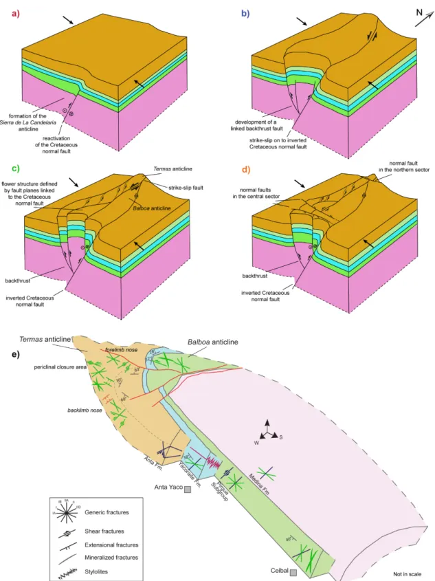
Structural and stratigraphic analyses conducted at the outcrop scale allowed to reconstruct the tectonic evolution of the Sierra de La Candelaria anticline (CHAPTER 3) highlighting the type and intensity of the deformation that affected the anticline in the different structural positions. Two main deformation phases were identified: an extension happened during the Cretaceous rifting and a positive inversion and folding occurred since Upper Miocene times. Accordingly, the regional anticline formed at the hanging wall of a N-S Cretaceous normal fault. This high-angle normal fault was reactivated as an oblique reverse fault since it had an oblique trend with respect to the WNW-ESE Andean shortening direction. The event of positive inversion can be divided into an early, intermediate and mature sub-stages of deformation. At the outcrop scale, tectonic stylolites and shears fractures mainly testify the early develop of the regional anticline. Progressively, in the intermediate stage, an oblique NNW-SSE fault plane enhanced the development of the minor Termas and Balboa anticlines. In correspondence of these anticlines, fault planes, with the associated Riedel shears, shear fractures, calcite- and gypsum-filling veins and deformation bands record both the strike-slip kinematics and the folding process related to inversion. E-W and ENE-WSW normal faults and extensional fractures are mainly associated to the mature stage of the deformation, recording the final stage of the folding process.
The performed three-dimensional model of the anticline together with the reservoir fracture modelling (CHAPTER 4) addressed to reservoir evaluation: i.e. lateral extent, thickness and volume, tectonic features, porosity/permeability patterns, possible reservoir compartments.
The results show a reservoir volume of 53 Km3 with a mean thickness of 450 m, confined to the east by the main high angle thrust fault that borders the anticline on the eastern side
and to the west by a continuous, almost N-S oriented, lineament well visible on remote sensing images. To the north, it is delimited by a normal fault plane trending E-W and dipping to the north. Whereas, to the south, the reservoir is confined by its outcrops and by a NE-SW strike-slip fault occurring in the Ceibal area. In the northern sector of the anticline, at the northern edge of Termas and Balboa anticlines, the reservoir deposits reach the maximum depths of ~2,100 m and ~2,400 m, respectively.
Focusing on this northern portion of the regional anticline considered as the most interesting for different heat uses since the thermal fluids reach the highest temperatures, a reservoir volume of 28 Km3 with a fracture portion of 0.001 Km3 were computed.
Furthermore, 1.89*1017 J of extractable geothermal heat was calculated from the reservoir
portion where temperature exceeds 60°C, at least for direct heat uses.
The reservoir fracture modelling confirm the interest for this area because of the high values of the computed secondary permeability and porosity (4.2E-04 and until ~20mD, respectively) as a result of the intensive brittle deformation that affect this portion of the anticline. The modelling also shows the highest secondary permeability values in the direction parallel to the strike of the main NNW-SSE fault plane. These results allow considering this fault plane as the main structure controlling the migration path of hot fluids at depth and their upwelling from the reservoir to the surface, as also demonstrated by associated calcite-filled veins. At the same time, the NNW-SSE fault plane may act as a barrier to fluid flow, producing a reservoir compartimentalization.
Paleo-thermal analyses conducted on the cap-rock of the geothermal system (CHAPTER 5), well exposed in this northern portion of the regional anticline, suggest that it acts as a good insulator. Clay mineralogy analyses indicate a low thermal maturity of these deposits with low amounts of illite in I-S mixed layers, comparable with the thermal maturity detected on the same deposits exposed along the western limb of the anticline, far away from the influence of the hot springs. Thermal and burial models reconstructed in the two investigated areas of the anticline, far away and close to the area of the hot springs, demonstrate that this thermal maturity represents the result of the burial history experienced by the cap-rock under a geothermal gradient of about 40 °C/Km stabilised after the rifting event. Furthermore, as demonstrated by vitrinite reflectance data computed for the post-rift Yacoraite Formation (0.6-0.7%), the rift succession experienced a thermal evolution compatible with late diagenetic conditions in the early stages of hydrocarbon generation during Upper Miocene times.
A high degree of the cap-rock thermal alteration (80% of illite in I-S mixed layers) occurs in correspondence of its most fractured portions. The R3 structures do not fit the performed purely conductive 1D thermal models. These results together with fluid inclusion analyses, that indicate an entrapment temperature (Th) of 115°C on the same fractured outcrops, suggest that hot fluids circulation may have played a key role in the thermal alteration of the cap rock only where it was intensely fractured. In this framework, deformation due to strike-slip kinematics rather than to folding process may have focused hot fluids and driven localized thermal alteration of the cap-rock.
Coupling these results together with the recently published geochemical, hydrogeological and audiomagnetotelluric data (Barcelona et al., 2013; Invernizzi et al., 2014; Chiodi et al., 2015) (CHAPTER 6), I suggest that the most favourable site for a potential future exploitation of the thermal fluids is located along the northern buried plunge of the Balboa anticline. The high temperatures reached by the thermal fluids in this area (~120°C) suggest that an undirect heat use for electric power generation could be feasible. Furthermore, the compartimentalization ruled by the NNW-SSE fault plane may guarantee, at the same time, the sustainability of the geothermal resource exploited at present by the Hotel Termas, in correspondence of the Termas anticline.
Riassunto
Le metodologie di esplorazione comunemente applicate nella ricerca di olio e gas, possono fornire importanti informazioni anche quando applicate nella prospezione di sistemi geotermici a media ed alta entalpia nella prospettiva di un loro sfruttamento e di una corretta gestione del reservoir.
L’obiettivo di questa Tesi è stato quello di valutare la possibilità di sfruttamento del sistema geotermico di Rosario de La Frontera attraverso un approccio di studio multidisciplinare basato sull’integrazione di differenti metodologie: indagini strutturali condotte alla scala dell’affioramento, modellazione delle rete di fratture nel reservoir geotermico attraverso il software MoveTM (Midland Valley Exploration Ltd.) e analisi paleo-termiche (analisi ottiche della materia organica dispersa nei sedimenti, quali la riflettanza della vitrinite: Ro%, analisi diffrattometriche a raggi X delle argille, studio microtermometrico delle inclusioni fluide, e modellazioni monodimensionali della storia termica e di seppellimento della successione in esame attraverso il software Basin Mod 1-D).
Il sistema geotermico di Rosario de La Frontera appartiene all’anticlinale Sierra de La Candelaria, una delle strutture invertite positivamente, affiorante nell’avampaese Sub-Andino in Argentina nordoccidentale. Nonostante la presenza di differenti siti termali situati lungo le strutture frontali della retrocatena andina, le alte temperature dei fluidi di questo sistema geotermico lo rendono uno dei siti più promettenti per un suo potenziale sfruttamento al fine di sostenere uno sviluppo sostenibile delle città della provincia di Salta. Questo sistema geotermico attivo è caratterizzato da diverse manifestazioni termali, con temperature comprese tra 24°C e 90°C, che emergono principalmente in prossimità della cittadina di Rosario de La Frontera, al margine settentrionale dell’anticlinale regionale. Le arenarie fratturate dei depositi Cretacici di sin-rift (Sottogruppo Pirgua) rappresentano il reservoir del sistema geotermico. Differentemente, i depositi di post-rift e sin-orogenici a bassa permeabilità (rispettivamente, Sottogruppo Balbuena e Santa Bárbara, e Sottogruppo Metán) agiscono principalmente come cap-rock. Questi depositi sono deformati in un’anticlinale allungata in senso N-S e tagliati da successivi piani di faglia normali e trascorrenti. L’anticlinale e le strutture associate (faglie e fratture) rappresentano il contesto strutturale del sistema geotermico.
Il presente studio si avvale di un approccio multidisciplinare allo scopo di valutare la qualità del reservoir e della cap-rock del sistema geotermico. Particolare attenzione è rivolta alla comprensione di come le faglie e le fratture influenzano la circolazione dei fluidi in profondità e la loro risalita in superficie. Le indagini applicate forniscono nuovi dati sull’evoluzione di questa struttura dell’avampaese Sub-Andino, precedentemente poco studiata, vincolando anche la storia termica e di seppellimento della successione sedimentaria dal Barremiano fino al Quaternario. Inoltre, l’integrazione con dati idrogeologici, geochimici e geofisici (audiomagnetotellurici) pubblicati (progetto CUIA 2010 – Cooperazione Universitaria Internazionale Italia-Argentina), ha consentito di elaborare un modello concettuale della circolazione dei fluidi termali identificando la migliore area per una potenziale perforazione nella prospettiva di uno sfruttamento indiretto dei fluidi termali (generazione di elettricità).
Le analisi stratigrafiche e strutturali condotte alla scala dell’affioramento hanno permesso di ricostruire l’evoluzione tettonica dell’anticlinale Sierra de La Candelaria (CAPITOLO 3) mettendo in luce il tipo e l’intensità della sua deformazione in diverse posizioni strutturali. Due principali fasi deformative sono state identificate: un’estensione avvenuta durante il rifting Cretacico, e un’inversione positiva e relativo piegamento nell’hanging wall, avvenuti a partire dal Miocene superiore. Secondo questa ricostruzione, l’anticlinale regionale si è sviluppata nell’hanging wall di una faglia cretacica orientata N-S. Tale piano di faglia ad alto angolo è stato riattivato con cinematica transpressiva, con un’orientazione non perfettamente ortogonale rispetto alla direzione WNW-ESE del raccorciamento regionale. L’evento d’inversione positiva è descrivibile in tre stadi evolutivi: precoce, intermedio e maturo. Alla scala dell’affioramento, stiloliti e fratture di taglio testimoniano principalmente il primo stadio di sviluppo dell’anticlinale regionale. Progressivamente, nello stadio intermedio, lo sviluppo di una faglia obliqua orientata NNW-SSE ha favorito la formazione delle due anticlinali minori, Termas e Balboa. In corrispondenza di queste due anticlinali, la cinematica trascorrente e il piegamento legato allo sviluppo di questa faglia obliqua, è registrato da diversi piani di faglia con i piani di riedel associati, fratture di taglio, vene di calcite e di gesso e deformation bands. Faglie normali e fratture estensionali orientate E-W e ENE-WSW sono principalmente associate allo stadio maturo della deformazione.
L’elaborazione di un modello tri-dimensionale dell’anticlinale insieme alla modellazione della fratturazione nel reservoir (CAPITOLO 4) ha consentito una valutazione del reservoir definendone estensione laterale, spessore e volume, caratteristiche strutturali, porosità/permeabilità secondaria e possibile compartimentalizzazione.
I risultati mostrano un volume di reservoir di 53 Km3 con uno spessore medio di 450 m,
confinato a est dal piano di faglia ad alto angolo che borda l’anticlinale lungo il suo fianco orientale e a ovest da un lineamento continuo orientato N-S, ben visibile dalle immagini satellitari. A nord il reservoir appare delimitato da un piano di faglia normale immergente a nord e orientato E-W. Mentre, a sud, risulta confinato dai suoi affioramenti e da una faglia trascorrente orientata NE-SW presente nell’area del Ceibal. Nel settore settentrionale dell’anticlinale, all’estremo nord delle anticlinali Termas e Balboa, il reservoir raggiunge le massime profondità rispettivamente di ~2100 m e ~2400 m.
Focalizzandosi su questa porzione settentrionale dell’anticlinale regionale, in quanto considerata la più interessante per differenti utilizzi del calore, è stato calcolato un volume di reservoir di 28 Km3 comprensivo di una porzione fratturata di 0.001 Km3. Inoltre, considerando solo la porzione di questo reservoir dove il calore eccede i 60°C (minima temperatura richiesta almeno per usi diretti del calore), risultano estraibili 1.89*1017 J di calore geotermico.
La modellazione della fratturazione nel reservoir conferma l’interesse per questa area per gli alti valori di porosità e permeabilità secondaria ottenuti (4.2E-04 e fino a ~20mD, rispettivamente), come risultato dell’intensa deformazione fragile che interessa questa porzione dell’anticlinale. La modellazione eseguita mostra anche valori più alti della permeabilità secondaria parallelamente alla direzione del piano di faglia orientato NNW-SSE. Questi risultati portano a considerare questo piano di faglia come il principale tragitto percorso dai fluidi in profondità e lungo il quale risalgono dal reservoir verso la superficie, come dimostrato anche da vene di calcite associate. Allo stesso tempo, il piano di faglia orientato NNW-SSE dovrebbe agire come barriera al flusso del fluido perpendicolarmente alla propria direzione, producendo una compartimentalizzazione del reservoir.
Le analisi paleo-termiche condotte sulla cap-rock del sistema geotermico (CAPITOLO 5), ben esposta nella porzione settentrionale dell’anticlinale, suggeriscono che agisce come un buon isolante termico. L’analisi mineralogica delle argille indica una bassa maturità termica di questi depositi con bassi contenuti di illite negli strati misti I-S, confrontabile alla maturità termica ritrovata negli stessi depositi affioranti lungo il fianco occidentale
dell’anticlinale, lontano dall’influenza delle emergenze calde. I modelli termici e di seppellimento, ricostruiti per le due aree investigate dell’anticlinale, vicino e lontano dai fluidi termali, dimostrano che questa maturità termica è il risultato del seppellimento subito dalla cap-rock con un gradiente geotermico di circa 40 °C/Km stabilitosi dopo l’evento di rifting. Inoltre, come dimostrato dai dati di riflettanza della vitrinite analizzata per la Formazione Yacoraite di post-rift (0.6-0.7%), i depositi di rift subirono un’evoluzione termica compatibile con le tarde condizioni diagenetiche nei primi stadi di generazione degli idrocarburi durante il Miocene superiore. Un alto grado di alterazione termica della cap-rock (80% di illite negli strati misti I-S) è registrata in corrispondenza delle sue porzioni fratturate. Queste strutture R3 non si adattano con il modello termico elaborato puramente conduttivo. Questi risultati insieme all’analisi delle inclusioni fluide, indicanti una temperatura di intrappolamento (Th) di 115°C negli stessi affioramenti fratturati, suggerisce che la circolazione dei fluidi deve aver giocato un ruolo chiave nell’alterazione termica della cap-rock solo dove era intensamente fratturata. La deformazione legata alla cinematica trascorrente, più di quella legata al processo di piegamento, deve aver guidato i fluidi caldi, determinandone un’alterazione termica localizzata.
Integrando questi risultati con i dati idrogeologici, geochimici e audio-magnetotellurici recentemente pubblicati (Barcelona et al., 2013; Invernizzi et al., 2014; Chiodi et al., 2015) (CAPITOLO 6), la zona ideale per un potenziale futuro sfruttamento dei fluidi termali risulta localizzata all’estremo nord dell’anticlinale Balboa. Le alte temperature raggiunte dai fluidi termali in quest’area (~120°C) suggeriscono un possibile utilizzo indiretto del calore per produzione di energia elettrica. Inoltre, la compartimentalizzazione prodotta dalla faglia orientata NNW-SSE dovrebbe garantire allo stesso tempo la sostenibilità della risorsa geotermica attualmente sfruttata dalla struttura termale dell’Hotel Termas in corrispondenza dell’anticlinale Termas.
CHAPTER I
INTRODUCTION
1.1 Problem
The basic conceptual model for a convection-dominated geothermal system includes three main elements: a heat source, a reservoir including a cap-rock that limits the heat escape, and a fluid (Dickson and Fanelli, 1994). Convection of the thermal fluids, induced by the heat source or elevated heat flow, transports heat from deeper levels to the surface.
Geological and hydrogeological studies represents the starting point of any geothermal exploration programme. They are mainly devoted to the identification and extension of the areas worth investigating and to the regional characterization of the macro-circulation (Serpen, 2004; La Vigna et al., 2012; Mazza et al., 2013).
Geochemical surveys are commonly applied to detect the composition, the origin, the thermo-baric state of the fluids and their migration paths (Truesdell and Hulston, 1980; Nuti, 1992; D’Amore and Bolognesi, 1994; Minissale et al., 2000; Magro et al. 2003; Minissale, 2004; Chiodini et al., 2005; Pierantoni et al., 2012; Barberi et al., 2013; Mwangi, 2013; Chiodi et al., 2012a, 2012b, 2015). They are commonly integrated with structural investigations in order to detect the structural channels controlling the fluid flow pathways and to analyse the fluid-rock interaction and the implications on permeability of hosting rocks (Liotta et al., 2010; Rossetti et al., 2011; Giordano et al., 2013; Invernizzi et al., 2014; Brogi et al., 2015). Furthermore, numerical models of coupled fluid and heat flow are increasingly used to improve the understanding of hydrothermal systems and their natural evolution, especially in fractured environments (Bertani and Cappetti 1995; Zhang and Sanderson 1996; Kloditz and Clauser 1998; Magri et al., 2010; Shaik et al., 2011; Barchi et al., 2013).
Most of the literature on geothermal exploration is also focused on the characterization of the reservoir by means of petrological and geophysical investigations (Majumdar et al., 2000; Lüschen, 2005; Finetti, 2006; Moeck et al., 2010; Barcelona et al., 2013; Ganguly
and Kumar, 2012, for a review) and on the evaluation of the P-T conditions (Erkan et al., 2008;De Benedetti et al., 2010; De Filippis et al., 2012). In this framework, seismic surveys are also addressed to detect the preferential upward migration paths for magmatic fluids (Brogi et al., 2003, 2005a, 2005b). Since most of the geothermal reservoirs all over the world are hosted in fractured rock media where the main flow occurs through a network of interconnected fractures, special regards is devoted to the modelling of its fracture network (Wang & Ghassemi, 2011; Müller et al., 2010; Maffucci et al., 2012a, 2013, 2015; Deckert and Bauer, 2015; Phillip, 2015).
Less attention has been generally addressed to the characterization of the cap-rock of a geothermal system. Its integrity is mainly analysed by means of soil CO2 flux and
hydrothermal alteration mineralogy (Cox and Browne, 1998; Yang et al., 2001; Todaka and Akasaka, 2004; Battaglia et al., 2007; Timlin, 2009; Todesco and Giordano, 2010; Di Paolo et al., 2012; Maffucci et al., 2012b; Corrado et al., 2014; Carapezza et al., 2015).
In this work, a multidisciplinary approach was applied to study the geothermal system of Rosario de La Frontera located at the northern edge of Sierra de La Candelaria anticline, in the Sub-Andean foreland of the Santa Barbara system (northwestern Argentina) (Fig. 1.1). Structural and paleo-thermal analyses and a fracture reservoir modelling were applied to investigate its reservoir and cap-rock in order to evaluate the possibility of exploitation of the thermal fluids. Furthermore, the integration with hydrogeological, geochemical and geophysical studies available on this geothermal system (Barcelona et al., 2013; Invernizzi et al., 2014; Chiodi et al., 2015) addressed to the main goal of this research.
1.2 Aims of the thesis and methodology
The studies carried out in this PhD project are aimed to evaluate the possibility of exploitation of potential medium- and low-enthalpy geothermal fields located in the province of Salta (northwestern Argentina) in order to improve the sustainable development of its cities.
Special regard was devoted to the geothermal system of Rosario de La Frontera (Salta province). This active geothermal system is marked by several hot springs with surface temperatures ranging between 24°C and 90°C that occur close to the Hotel Termas thermal spa. One further hot spring (~ 38°C) occurs a few tens of kilometres along the south-western flank of the ridge.
The high temperature of its thermal fluids makes it as the most promising site for the supplying energy in the Sub-Andean foreland of the Salta province.
Fig. 1.1 – Location of the study area (from Chiodi et al., 2015)
The Cretaceous deposits of the Salta Group (Pirgua Subgroup) provide the reservoir of this system. They consist of continental deposits, mainly represented by sandstones and conglomerates, related to the syn-rift stage (Late Neocomian – Early Maastrichtian). On the contrary, the low permeable post-rift and the syn-orogenic deposits (respectively, Balbuena and Santa Bárbara subgroup, and Metán subgroup) provide the cap-rock to the system. These deposits are deformed in a N-S trending hanging wall anticline (Sierra de La Candelaria) and dissected by subsequently strike-slip and normal faults. The anticline and the associated structures (faults and fractures) represent the structural context of the studied geothermal system.
The purpose of this research is to assess the quality of the reservoir and cap-rock of this geothermal system through a multidisciplinary approach based on the integration of
different methodologies: paleo-thermal and structural analyses, and modelling of the reservoir fracture network.
Paleo-thermal analyses are typical of the Basin Analyses field, mainly applied by oil companies for exploration. The applied methodology include the optical analyses of the organic matter dispersed in sediments correlated to the X-ray diffraction study of clay minerals, and the fluid inclusions analyses on veins. Results were used to build mono-dimensional thermal and burial models, and allowed to reconstruct the thermal history and the origin of the thermal anomaly of the studied geothermal system. Furthermore, the integration with structural investigations performed at the outcrop scale allowed to assess the quality of its cap-rock as a function of thermal vs fracturing state.
Structural investigations were also useful to elaborate a reliable tectonic model of the studied anticline. Moreover, structural data collected at the outcrop scale were used to model the fracture network in a 3-D volume of the geothermal reservoir reconstructed on the base of the 3-D geological cross-sections with the aid of a dedicated software. The results addressed to reservoir evaluation: i.e. lateral extent, thickness and volume, tectonic features, porosity/permeability patterns and possible reservoir compartments.
In addition, thanks to the cooperation with others research groups working on the same geothermal system (CUIA University Cooperation Italy-Argentina project 2010), the present work was integrated with others exploration methodologies: hydrogeological, geochemical and geophysical (audiomagnetotellurics) analyses. The integration allowed to evaluate the sustainability of the geothermal resource through the elaboration of a conceptual model of the fluid reservoir.
As a result, the most favourable site for drilling purposes, in perspective exploitation and reservoir management, and a possible use of the thermal fluids are indicated.
1.3 Outline of the Thesis
Following this introductory part (Chapter 1), this thesis is divided into other five parts. In Chapter 2 an overview of the geological and structural evolution of the Sub-Andean foreland is given, with major focus placed on the Santa Barbara System in general and the Sierra de La Candelaria in particular. The contribution of this work to the geological knowledge of the studied area is also explained.
In Chapter 3 a possible model for the tectonic evolution of the Sierra de La Candelaria anticline is proposed, based on the collected structural data. The results presented in this
chapter are also illustrated in the article “Quality assessment of reservoirs by means of outcrop data and discrete fracture network models: The case history of Rosario de La Frontera (NW Argentina) geothermal system” published by Maffucci et al. in Tectonophyisics (2015).
In Chapter 4 the reservoir evaluation and the modelling of its fracture network is illustrated.
In Chapter 5 the burial and thermal evolution of the studied geothermal system as well as the integrity of its cap-rock is discussed on the base of the paleo-thermal analyses. Theoretical aspects and analytical procedures of the applied methodologies are also explained. The applied methods comprise: i) Organic matter thermal maturity studies; ii) XRD analyses and iii) Fluid Inclusions studies.
In Chapter 6 final remarks on the main results achieved by the entire research are presented.
CHAPTER II
PREVIOUS STUDIES AND OPEN PROBLEMS
2.1 Introduction
The research interest of this study is the geothermal system of Rosario de La Frontera belonging to the Sierra de La Candelaria anticline. This latter represents one of the positively inverted structure cropping out in the Sub-Andean foreland of the Santa Barbara System.
The northwestern Argentine territory (NOA) is characterized by numerous thermal springs along the frontal structures of the Andean retro-wedge (Pesce, 2000). These thermal manifestations are aligned in a N-S direction and can be traced until the Argentina-Bolivia boundary, to the north, and the Santiago del Estero province, to the south (Fig. 2.1).
These manifestations are mainly associated to medium- and low-enthalpy convective geothermal systems. Unlike the high-enthalpy geothermal systems of the Puna plateau (Pesce and Miranda, 2003; Giordano et al., 2013), they are located in populated areas and therefore they have a high potential for exploitation both for therapeutic and bathing purposes, as at present, and for direct use of heat.
In detail, the southernmost thermal area of the NOA is represented by Termas de Rio Hondo (Santiago del Estero province). In this area, fourteen thermal springs occur at surface with temperatures ranging between 35° and 60°C. The thermal complex of Rio Hondo represents the most important centre of health tourism in Argentina.
Northward, the thermal areas of El Saladillo, El Galpón, and El Sauce characterize the Salta province. The temperature of their thermal springs at surface ranges between 18° and 64°C. To the north, in the region of “El Ramal Jujeño”, in the eastern portion of the Jujuy province, occur the thermal areas of Aguas Caliente de Caimancito, Laguna La Quinta and Termas El Palmar. Their thermal springs show surface temperatures between 37°C and 58°C. In this province, are also present the thermal areas of Termas de Reyes, Puesto Viejo and Cachipunco with temperatures of the thermal springs between 24° and 52°C.
In these areas, little thermal complexes offer mainly balneology services for the local populations.
Fig 2.1 – Thermal areas occurring in the northwestern Argentina (Region NOA) (from Pesce, 2000).
Among all these thermal manifestations, the springs of Rosario de La Frontera system, located in the southern portion of the Salta province, are characterized by the highest temperatures at surface. This feature makes this site as the most interesting to improve the sustainable development in this area by the exploitation of the hot springs for direct and indirect heat uses such asspace heating, greenhouses, industry, aquaculture, domestic use and production of electricity.
At present, its thermal springs are exploited for therapeutic purposes by the Rosario de la Frontera thermal complex, financially supported by the Salta Province government. It
represents the first thermal centre used under a medical criteria in Argentina and in South America, created by the Spanish doctor Antonio Palau in 1878 (Canton, 1896).
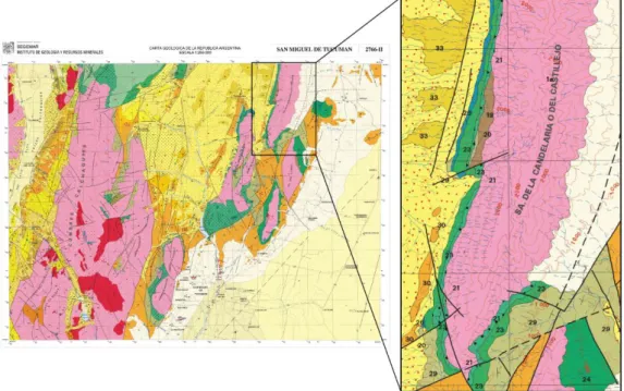
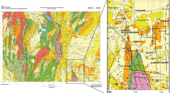
Form a geological point of view, the system of Rosario de La Frontera is located in the southernmost portion of the Santa Barbara system, to the south of the Metán basin (Fig.1.1). Published works on this foreland segment are mainly referred to its northern portion (Ruiz Huidobro 1968; Mingramm et al. 1969; Gebhard et al. 1974; Mon 1976; Gómez Omil and Albariño 1996; Kley and Monaldi 1999; Kley and Monaldi, 2002). Poor available works on the southern area are mainly focused on the Metán depression (Mon, 1971, 1972; Mon and Dinkel, 1974; Gónzalez and Mon, 1996; Grier et al., 1991; Cristallini et al., 1997; Iaffa et al., 2011, 2013). In particular, previous investigations of the Sierra de La Candelaria anticline are mainly focused on the chemistry and circulation of the thermal springs of Rosario de La Frontera system (Moreno Espelta et al., 1975; Seggiaro et al., 1995, 1997). Poor structural investigations on the anticline provided a kinematic interpretation invoking only a generic model of positive inversion based on structural pieces of evidence collected at regional scale (Moreno Espelta et al., 1975; Seggiaro et al., 1997; Iaffa et al., 2011; Iaffa et al., 2013), and on the base of a geomorphological and morphostructural characterization at local scale (Barcelona et al., 2014).
In this framework, one of the goals of this work is to give a new and recent geological contribute on a structure poorly studied of the Sub-Andean foreland. The original results presented in this work provide a kinematic evolutionary model of the studied anticline in an integrated framework that was missing in the past literature. Furthermore, the implications on the geothermal system object of interest of this work, allow to better understand the mechanisms controlling all the geothermal systems located along the Sub-Andean foreland.
For these aims, the geological framework given below will also refer to the broader studying site, as well as aspects of geodynamic and stratigraphic evolution, and the current structural configuration of the Sub-Andean foreland.
2.2 Geodynamic framework
2.2.1 The Central Andes
The Andean chain represents the result of the crustal deformation produced by the active subduction of the Nazca Plate beneath the South American Plate. This margin was defined as an “Andean type” according to the classification of Dewey & Bird (1970).
Along strike structural differences of the chain have been mainly related to dip changes in the subducted Nazca oceanic plate, to the pre-existing geological structures and lithological composition of the upper crust and to the thermal evolution of the litosphere (Barazangi & Isacks 1976; Allmendinger et al. 1983, 1997; Allmendinger and Gubbels, 1996; Jordan et al. 1983; Jordan & Alonso 1987; Isacks, 1988; McQuarrie, 2002; Babeyko & Sobolev 2005; Oncken et al. 2006).
In its central portion (in Bolivia, northern Chile and Argentina), where shortening is greatest, the orogen is highest and widest (James, 1971; Isacks, 1988; Kley and Monaldi, 1998; Beck and Zandt, 2002; McQuarrie et al., 2005; Oncken et al., 2006; De Celles et al., 2011).
The Central Andes are characterized by the dominance of protracted magmatic activity in the west (widely distributed around the Western Cordillera, i.e. the arc) and of tectonic shortening in the east (in the Eastern Cordillera and adjacent areas). Eastward from the modern forearc region, at ~ 25°S in the northwest Argentina, the orogen can be divided into four longitudinal structural regions, including the active volcanic arc of the Western Cordillera, the Altiplano‐Puna plateau, the Eastern Cordillera (a bivergent fold-thrust belt) and the Santa Barbara System foreland (Allmendinger et al., 1997; Strecker et al., 2007). Eastward of this fold-thrust belt adjoins the flat plain of the Chaco, which forms the recent retroarc foreland basin of the Central Andes (Fig. 2.2a).
2.2.2 The Santa Barbara System
The Santa Barbara System of northwestern Argentina represents a 400 km long segment of the Subandean foreland thrust belt characterized by predominantly west verging high-angle thrust faults with detachment level at mid-crustal depths (10-25 Km) (Allmendiger et al., 1983; Grier et al., 1991; Cristallini et al., 1997; Kley and Monaldi, 2002) (Fig. 2.2a,b).
By contrast, the sub-Andean belt to the north is a thin-skinned fold and thrust belt detached along a Silurian shale unit extended at a regional scale (Mingramm et al., 1979; Allmendinger et al., 1983; Aramayo Flores, 1989; Baby et al., 1989, 1992; Dunn et al., 1995). Furthermore, the Sierras Pampeanas to the south is an extensive province of basement uplifts associated with deep-reaching thrusts or reverse faults that dip moderately eastward and westward (González Bonorino, 1950; Allmendiger et al., 1983; Jordan and Allmendinger, 1986). Differences in the tectonic style along-strike correlates with changes in the dip of the subducted Nazca plate beneath the continental margin, in major paleogeographic structures and sedimentary basins distribution, and with a north-south
change in the upple mantle structure (Pilger, 1981; Allmendinger et al.,1983; Jordan et al., 1983; Withman et al., 1992; Kley et al., 1999).
a)
b) Fig 2.2 – a) Map illustrating the structural provinces in the northwestern Argentina (Region NOA) and b)
a balanced cross section of the Transition Zone at 25°30’S. Its trace is indicated in the map. Heavy dashed lines denote the approximate boundaries of the Salta rift (white arrows on down- thrown side) (from
Reynolds et al., 2011).
In detail, the Santa Barbara System is located in correspondence of the Transition Zone where the Nazca oceanic plate changes its dip from flat, to the south, to “normal” (about 30° dip) to the north at 27° S latitude (Barazangi and Isacks, 1976; Cahill and Isacks, 1992;
Gutscher et al., 2000; Ramos et al., 2002). Furthermore, the upper crust in the studied region has a strong segmentation that reflects inherited stratigraphic and structural inhomogeneities related to the succession of tectonic events occurred since early Palaeozoic times (Allmendinger et al., 1983; Mpodozis and Ramos, 1989; Kley et al., 1999). From that time on, different reactivation events took place in the area. One major event occurred in Late Cretaceous times, when extension favoured the opening of a back-arc rift basin (Salta Rift) (Salfity & Marquillas 1981; Monaldi et al. 2008) constituted by a series of extensional troughs or sub-basins (e.g. Sey, Tres Cruces, Brealito, Tucumán, Choromoro, El Rey, Lomas de Olmedo, Metán) (Fig. 2.3).
Fig 2.3 - Main basins forming the Cretaceous Salta Rift. The rift basin developed in a series of
sub-basins that were partially connected (from Iaffa et al., 2013).
The Andean orogeny with its deformation started to imprint its effects in the study region in the Eocene (Coutand et al. 2001; Carrapa et al. 2005; Carrera et al. 2006; Hongn et al. 2007). Since then, deformation has propagated towards the east but with jumps back to the west intercalated in an out-of-sequence deformation (Salfity et al., 1993; Carrera et al. 2006; Carrera & Muñoz, 2008; Hain et al., 2011).
The stratigraphic succession comprises three major sequences (Fig. 2.2b): (1) A basement of Precambrian to early Cambrian low grade metasedimentary rocks (Pankhurst & Rapela, 1998; Omarini et al., 1999; Aceñolaza et al., 2002; Aceñolaza, 2005) is overlain with a regional angular unconformity by (2) a predominantly continental succession of red beds with minor limestone intercalations (Salta Group) including syn-rift, and post-rift deposits. The latter are capped by (3) a thick continental foreland basin fill that was shed from the rising Andes in the west in Eocene to Recent time (Coutand et al. 2001; Carrapa et al. 2005; Carrera et al. 2006; Hongn et al. 2007).
From a structural point of view, the area is dominated by spatially and temporally disparate range trending north to NNE, uplift along steeply dipping inherited faults from the Cretaceous rift (Grier et al., 1991; Mon and Salfity, 1995; Cristallini et al., 1997, Kley and Monaldi, 2002) (Fig. 2.2a). The present topography shows a strong segmented foreland characterized by different interconnected sub-basins. Among them, the Metán Basin is located in the southernmost portion of the Santa Barbara system.
Furthermore, a thin mantle lithosphere and a low flexural rigidity have been shown in this segment of the Sub-Andean foreland (Withman et al., 1992, 1994, 1996). Petrologic data suggest that the thinned foreland lithosphere may in part be inherited from a thermal anomaly established during mantle-activated Cretaceous rifting (Lucassen et al., 1999; Kley and Monaldi, 2002). Accordingly, a relatively high heat flow (100-120 mW/m2) is indicated in the area (Hamza and Muñoz, 1996; Hamza et al., 2005; Cardoso et al., 2010; Vieira and Hamza, 2014) (Fig. 2.4).
2.2.3 The Metán basin
The striking feature of the Metán basin is represented by the variety of structural trends (Kley and Monaldi, 2002; Iaffa et al., 2013). Interaction between the older reactivated faults and the newly generated ones gave rise to a complex pattern of fold interference (Mon, 1976; Grier et a., 1991; Cristallini et al., 1997; Kley and Monaldi, 2002; Carrera et al., 2006; Iaffa et al., 2011, 2013).
Anisotropies produced during the Precambrian to Palaeozoic tectonic cycles shaped the basement fabric, producing discontinuities that were reutilized in posterior tectonic stages (Iaffa et al., 2011). Some of these structures were reactivated during the Salta Rift and others in the different stages of the Andean deformation (Cristallini et al., 1997; Iaffa et al., 2013). As a result, the general structural trend of the area is dominated by N-S, NE-SW and NNE-SSW thrust faults and folds. The oldest Andean compressive structures in the study
area was probably the N-S Sierra de Metán Thrust Fault and its hangingwall anticline, and resulted from W-E shortening (Iaffa et al., 2011).
Fig 2.4 – Heat Flow map of the south America (from Cardoso et al., 2010).
In this framework, during the Andean orogeny, pre-existent rift faults with an orientation unfavourable to reactivation acted as a buttress favouring an inward migration of the deformation with the formation of out of sequence thrusts (Iaffa et al., 2011).
The absence of important thicknesses of marine deposits or evaporites in the basins that in posterior compressive stages could act as ductile layers is a factor contributing to the tectonic reactivation of previous structural discontinuities (Iaffa et al., 2011). Shallower
detachment levels only acted in the last stages of the Andean deformation, when inter-montane basins were locked by the uplifted basement ranges and the system was buttressed.
The Sierra de La Candelaria anticline represents one of these uplift basement ranges. It delimits to the south the Metán basin.
2.3 Sierra de La Candelaria anticline
Despite some early studies, the Sierra de La Candelaria structure is poorly documented. Moreno Espelta et al. (1975) and Seggiaro et al. (1995, 1997) provided a first description of the stratigraphy and geology of the anticline with the aim to define the structural framework of the thermal springs of Rosario de La Frontera area.
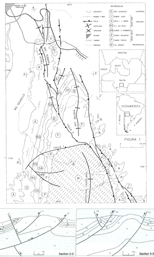
Sierra de La Candelaria ridge consists of a broad anticline bifurcated, in the northern portion, in two minor anticlines both dipping to the north: Termas and Balboa, separated by a NNW-SSE to N-S fault plane (Fig. 2.5).
Its stratigraphic succession covers a wide time span: from pre-Cambrian to Pliocene-Quaternary times (Moreno Espelta et al., 1975) (Fig. 2.5). The oldest stratigraphic unit crops out in the core of the anticline. It is the Precambrian basement made up of low grade metasedimentary rocks (Medina Formation) that, in the northern portion and along the western limb of the anticline, is unconformably overlain by a thick succession of continental Cretaceous to Paleogene strata (Salta Group) related to the Cretaceous rift stage (Turner, 1959; Salfity, 1982; Galliski and Viramonte, 1988; Salfity and Marquillas, 1994; Viramonte et al., 1999; Marquillas et al., 2005).
The Early to Late Cretaceous Pirgua subgroup, marks the syn-rift fill stage (Salfity and Marquillas, 1994), whereas the Balbuena and Santa Bárbara subgroups represent the post-rift thermal subsidence stage (Bianucci et al., 1981; Salfity and Marquillas, 1994; Comnínguez and Ramos, 1995). Post-rift deposits are in turn overlain by a thick continental foreland basin fill, related to the Andean mountain uplift and erosion, that was deposited from Middle Miocene to Pliocene–Quaternary times (Gebhard et al., 1974).
The retrowedge basin fill includes two subgroups (Metán and Jujuy, according to Gebhard et al., 1974) belonging to the Orán Group. The main outcrops of these subgroups cover the northern portion of the Sierra de La Candelaria ridge at the lowest elevations.
The stratigraphic succession cropping out along the Sierra de La Candelaria ridge forms an anticline whose general trend is N-S. It is located in the hanging wall of a N-S high-angle fault that borders the structure along its eastern margin.
Fig 2.5 – Geological map of the northern portion of the Sierra de La Candelaria anticline from Seggiaro et
al. (1997). According to the authors, the reverse fault “falla 2” bordering the anticline along its eastern margin is the responsible of the uplift of the anticline. The reverse fault “falla 3” in the central area, divides
the structure in two anticlines: Termas and Balboa. In section 2-2’, the E-W inverted normal fault “falla1” is cut at depth by the N-S thrust fault plane.
Seggiaro et al. (1995), throughout balanced cross sections, constrained the detachment level of this fault plane at 10 Km of depth, in correspondence of the metamorphic basement of Medina Formation (Fig. 2.5). Later, Seggiaro et al. (1997) argued as the central NNW-SSE fault plane, detached within the syn-rift deposits (Pirgua Subgroup), may be the responsible of the uplift of Termas anticline enhanced by a linked N-S backthrust. In their structural interpretation, an E-W inverted normal fault delimits to the south the Balboa anticline and is cut at depth by the N-S thrust fault.
González et al. (2000) were the first to describe the southern portion of the anticline. They defined a left-lateral NE-SW strike-slip fault in the southern area of Ceibal (Fig. 2.6).
Fig. 2.6 – Geological map of the southern portion of the Sierra de La Candelaria anticline (from González
et al., 2000). The structure is dissected by a left-lateral strike-slip fault. Others NNW-SSE and NE-SW fault planes dissect the southernmost portion of the structure with reverse and strike-slip kinematics,
respectively.
Later, Salfity and Monaldi (2006) provided a detailed mapping of the northern portion of the anticline. They described the NNW-SSE fault plane dividing the two anticlines as an oblique fault plane. Branches of the fault splay off to the northwest. Two E-W fault planes delimits to the south the Balboa anticline cutting the N-S thrust fault that borders the structure on the eastern side (Fig. 2.7).
Recently, Iaffa et al. (2011) by reconstructing the structural style of this portion of the Sub-Andean foreland on the base of seismic and field data, established that the N-S fault plane flanking the anticline to the east represents a former Salta Rift extensional fault.
A new interpretation of the uplift evolution and growth of this mountain range was proposed by Barcelona et al. (2014) on the base of an integrated analysis of geomorphology and morphostructural characterization. They reconstructed a multi-stage development of the Sierra de La Candelaria range identifying three morpho-structural segments uplifted at different times. The first stage uplifted the central segment. Accordingly, the Balboa anticline might precedes the Termas anticline representing the northern ancient nose of the Sierra de la Candelaria range. After a significant time lapse, the mountain range was subjected to southward thick-skinned growth and northward growth via stepwise thin-skinned deformation. The development of the southern segment of the Sierra de la Candelaria range could have induced a concomitant uplift of the central segment through mechanical coupling, which evolved into a second stage of vertical development of the central segment. This stage of uplift could have been controlled by the development or reactivation of a blind antithetic thrust, forming a pop-up structure style. Progressively, the final northward thin-skinned deformation stage developed the Termas anticline with a detachment zone located in a clay-bearing level of the Pirgua Subgroup, in agreement with the structural model of Seggiaro et al. (1997).
Fig. 2.7 – Geological map of the northern portion of the Sierra de La Candelaria anticline (from Salfity
and Monaldi, 2006). See text for details.
2.4 Rosario de La Frontera geothermal system
At the northern edge of Sierra de La Candelaria anticline are located the thermal springs of Rosario de La Frontera geothermal system.
In 1876 Dr. Max Siawert started studying water chemistry in the area, four years later Dr. Antonio Palau began the exploitation of thermal springs for commercial purposes. In 1888, Doctors Doering and Schikendantz, and Dr. Tagliabue in 1895, proved the occurrence of nine different kinds of waters, which turned the “Termas de Salta” (as it was known until the end of the nineteenth century) to be a privileged place for therapeutic purposes (Rivas, 2012).
Seggiaro et al. (1995) were the first to study the chemistry, temperature and pH of the thermal springs providing data for five samples. Only recently Chiodi et al. (2015) have produced an exhaustive dataset of the thermal springs and of the dissolved gases of 13 thermal discharges (hot springs and bubbling pools with temperatures up to 90.5 °C), with the aim to construct a conceptual model of the circulation of the thermal fluids at depth (Fig. 2.8; Tables 2.1, 2.2).
Fig. 2.8 – (a) Morphotectonic map of the Termas anticline and (b) 3D-image of the studied area. Sampled
thermal springs are illustrated (from Chiodi et al., 2015).
Their results are in accordance with the occurrence of two aquifer previous detected, at ~2400 and ~150 m depth, by Barcelona et al. (2013) and Invernizzi et al. (2014) on the base of audio-magnetotelluric and hydrogeological investigations, respectively.
The deepest hydrothermal reservoir, hosted within the Cretaceous Pirgua Subgroup deposits, is mainly recharged by meteoric water and shows a Na–HCO3 composition with
significant contributions of crustal CO2 and He from mantle degassing through the fault
systems that dissect the anticline. The uprising thermal fluids mix with a relatively high salinity Na–Cl dominated aquifer produced by the interaction of meteoric water with shallow evaporitic deposits of the Anta Formation (Fig. 2.9).
Table 2.1 – Outlet temperatures (in °C), pH, chemical composition, δ34S–SO
4 (expressed as ‰ vs. V-CDTδ18O and δ2H (both expressed as ‰ vs. V-SMOW) and δ11B
(in ‰) values of the RFHS fluid discharges. Concentrations of solutes are in mg/L; n.a.: not analyzed. (from Invernizzi et al. 2014 and Chiodi et al., 2015).
Sample Lat. Long. Altitude
(m) T° pH HCO3 F -Cl -Br -NO3 -SO4 2-Ca2+ Mg2+ Na+ K+ NH4+ B SiO2 δ34 S-SO4 δ18 O-H2O δD-H2O δ11 B RF01 25,84 64,93 924 74,0 6,75 169 2,3 313 0,06 0,63 128 11 0,5 305 4,3 0,05 0,12 92 n.a. -7.0 -38 RF02 25,84 64,93 905 81,2 6,88 156 1,8 682 0,23 0,53 190 10,6 0,5 587 7,4 0,06 0,18 88 6,99 -6,9 -38 RF03 25,84 64,93 918 71,4 7,06 201 8,8 16000 2,08 0,11 2100 326,1 20,1 11200 80,8 0,07 0,23 47 n.a. -7,1 -40 0,87 RF04 25,84 64,93 865 24,1 6,84 315 8,7 5340 1,98 6,13 3010 439,7 63,5 4290 17,4 0,05 0,33 54 6,31 -6,4 -38 1,05 RF05 25,84 64,93 948 52,7 6,42 198 1,9 137 0,19 1,17 146 32 1,5 188 2,7 0,05 0,21 94 n.a. -6,8 -37 RF06 25,84 64,93 960 64,8 6,09 149 0,7 270 0,24 1,38 104 5,1 0,1 288 4,0 0,07 0,39 89 n.a. -6,6 -36 RF07 25,84 64,93 967 58,2 6,73 224 2,5 42 0,11 1,51 103 15 0,7 147 1,7 0,13 0,27 85 n.a. -6,6 -36 13,8 RF08 25,84 64,93 954 74,9 6,83 219 1,5 122 0,08 0,96 143 22 0,9 193 2,3 0,07 0,15 87 5,87 -6,6 -37 RF09 25,84 64,93 894 24,2 7,36 279 1,5 2510 1,55 2,72 626 75 10,9 1900 17,4 0,11 0,45 51 5,42 -6,6 -38 RF10 25,84 64,93 928 90,5 6,12 171 2,5 276 0,15 0,22 187 3,9 0,2 321 5,7 0,09 0,28 102 7,32 -6,9 -39 12,6 RF11 25,84 64,93 942 90,4 6,39 190 8,0 254 0,18 0,85 180 14 0,3 294 5,6 0,28 0,35 108 n.a. -6,5 -36 RF12 25,84 64,93 867 45,2 6,77 215 2,3 80 0,07 0,27 155 4,6 0,28 206 4,7 0,26 0,44 116 n.a. -6,6 -36 RF13 25,84 64,93 918 72,2 6,26 210 2,0 133 0,11 0,39 140 3,2 0,1 227 5,3 0,20 0,51 124 n.a. -6,5 -37
Table 2.2 – Chemical composition, δ13C in CO
2 and CH4 (both expressed as ‰ vs. V-PDB) and R/Ra values of the bubbling and dissolved gases from the RFHS.
Concentrations are in mmol/mol; n.d.: not detected. (from Chiodi et al., 2015).
Sample type CO2 H2S N2 CH4 Ar O2 Ne H2 He C2H6 C3H8 i-C4H10 n-C4H10 i-C4H8 i-C5H12 n-C5H12 C6H6 δ13
C-CO2 R/Ra δ13 C-CH4 RF01 dissolved 209 n.d. 756 0,011 17,4 18 0,0093 n.d. 0,0015 n.d. n.d. n.d. n.d. n.d. n.d. n.d. n.d. -6,56 RF02 bubbling 956 3,6 28 0,051 0,59 12 0,0003 0,015 0,0044 0,00061 0,00005 0,00004 0,00003 0,00003 0,00002 0,00003 0,00011 -4,11 1,15 -39,3 RF03 dissolved 168 n.d. 803 0,005 16,9 12 0,009 n.d. 0,0021 n.d. n.d. n.d. n.d. n.d. n.d. n.d. n.d. -7,13 RF04 dissolved 139 n.d. 841 0,087 19 2,3 0,010 n.d. 0,0011 n.d. n.d. n.d. n.d. n.d. n.d. n.d. n.d. -5,66 -41,5 RF05 dissolved 575 n.d. 385 0,011 8,9 31 0,005 n.d. 0,0061 n.d. n.d. n.d. n.d. n.d. n.d. n.d. n.d. -5,16 RF06 dissolved 889 n.d. 106 0,051 2,39 2,66 0,0015 n.d. 0,0021 0,00061 0,00002 0,00003 0,00002 0,00005 0,00003 0,00002 0,00018 -4,15 -41,4 RF08 dissolved 212 n.d. 755 0,115 18,5 14 0,010 n.d. 0,0013 n.d. n.d. n.d. n.d. n.d. n.d. n.d. n.d. -11,49 RF09 dissolved 296 n.d. 676 0,009 17,1 11 0,009 n.d. 0,0024 n.d. n.d. n.d. n.d. n.d. n.d. n.d. n.d. -4,11 RF10 dissolved 960 1,2 36 0,087 0,77 2,3 0,0004 0,011 0,0042 0,00077 0,00004 0,00005 0,00002 0,00004 0,00002 0,00003 0,00015 -3,66 0,98 -40,6 RF11 dissolved 550 n.d. 415 0,015 9,8 25 0,006 n.d. 0,0027 n.d. n.d. n.d. n.d. n.d. n.d. n.d. n.d. -4,44 RF13 dissolved 954 n.d. 44 0,069 0,89 1,5 0.0005 0,022 0,0033 0,00078 0,00003 0,00002 0,00004 0,00006 0,00003 0,00004 0,00021 -3,77 -39,8 19
The temperature of the main hydrothermal reservoir, the deepest one, estimated with water geothermometers, is in the range of 100°-130°C (Seggiaro et al., 1995; Chiodi et al., 2015). A preliminary evaluation of the volume of this aquifer, hosted within Cretaceous sedimentary units, was made by Invernizzi et al. (2014). It accounts for 39 km3. On the base of the integration of hydrogeological, structural and chemical (isotopic analyses) investigations, the same authors provided a preliminary conceptual model of the geothermal fluid reservoir. They constrained the recharge area of the geothermal system of Rosario de La Frontera close to the area of the thermal baths, located in the northern sector of Sierra de la Candelaria. Temperature acquisition are achieved at depth where the infiltrated water reaches the base of the reservoir. A fast water ascent is driven by fracture systems well developed in correspondence of the northern end of the plunging structure. Furthermore, a long residence time of water at depth (over 50 years) is indicating by 3H data suggesting a long timing for the aquifer recharge (Invernizzi et al., 2014).
Fig. 2.9 – Three-dimensional conceptual model of the underground fluid circulation of Rosario de La
Frontera geothermal system (from Chiodi et al., 2015).
According to this model of circulation, considering a surface water temperature of 20 °C (Invernizzi et al., 2014) and a local geothermal gradient of ~40 °C/km (Seggiaro et al., 1995), recharging meteoric water reaches reservoir temperatures at 2100–2900m depth,
consistent with the difference between the average altitude of the recharge area (1680 m a.s.l.) and the depth of the Pirgua Subgroup (1100-1500 m b.s.l.) (Chiodi et al., 2015).
On the base of this reconstruction, Invernizzi et al. (2014) and Chiodi et al. (2015), considering an average reservoir temperature of ~90°C and ~115 °C, respectively, proposed a preliminary evaluation of the energy potential of the Rosario de La Frontera geothermal system estimating the heat stored in the fluid phase in the order of 1018 J.
CHAPTER III
TECTONIC MODEL OF SIERRA DE LA CANDELARIA
ANTICLINE
3.1 Introduction
The chapter focuses on structural data collected at the outcrop scale along the Sierra de La Candelaria anticline in order to understand their relationships with the main deformation events that affected the anticline and their influence on fluids migration.
The analyses of the collected data, together with the evaluation of the structural relationships between the anticline and the faults mapped in the area, and the geometry of the different stratigraphic units allowed to better constrain the structural setting of the anticline and to elaborate a multi-stage model that explains its formation and evolution.
3.2 Structural analysis at the outcrop scale
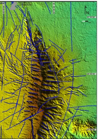
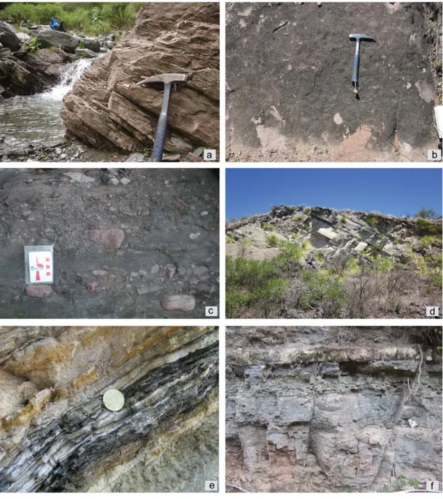
Field work was dedicated both to qualitative and quantitative analysis (orientation, dimension, spatial distributions, mode of deformation and spacing) of structural data recorded in the outcropping sedimentary succession. I tried to collect structural data in different areas of the anticline, along the forelimb, the backlimb and in the northern plunging nose, in order to illustrate the relationship of the structural data features to folding and their influence on fluid flow. Unfortunately, the Sierra de La Candelaria structure is densely covered by shrubby vegetation, and exposures are restricted mostly to river beds, river banks, railroad and highway cut. Therefore, the outcrops condition together with the difficulty to catch them very limited the distribution of measure sites along the anticline. Anyway, structural data on faults, cleavages, fractures, and veins were collected at 95 georeferenced field sites (Fig. 3.1).
In detail, structural data were collected in the Guanaco, Jesús María, Anta, Yacoraite, Pirgua and Medina Formations. The first three formations are mainly exposed in the northern portion of the ridge; Anta Formation extensively crops out both in the crestal
sector of Termas anticline and along the western limb of the main anticline. On the contrary, Yacoraite Formation and Pirgua Subgroup are widely exposed along the limbs in the central sector of Balboa anticline and in the southern sector of the ridge.
Fig. 3.1 – (a) Geological Map of Sierra de La Candelaria anticline. (b) Chronostratigraphic column showing
the tectonostratigraphic units cropping out in the study area, as well as the main tectonic events that controlled their deposition (redrawn by Carrera et al., 2006). (c) Representative cross sections of the
anticline. Their location is indicated in the geological map.
I identified in the field faults, generic fractures (e.g. defined as discontinuities with small aperture not sufficient to exclude a shear component during the opening, isolated weathered fracture) (Tavani et al., 2008), shear fractures, deformation bands, gypsum- and calcite-filled veins, and tectonic stylolites.
3.2.1 Southwestern Backlimb
Along the south-western limb of the main Sierra de La Candelaria anticline, structural data were collected in two different sectors: Anta Yaco (north) and Ceibal (south) (Fig. 3.1). In the Anta Yaco area, structural analysis were performed on Anta, Yacoraite, Pirgua and Medina Formations. Conversely, in the Ceibal area structural data were collected from the outcrops of Pirgua Subgroup and Jesús María Formations.
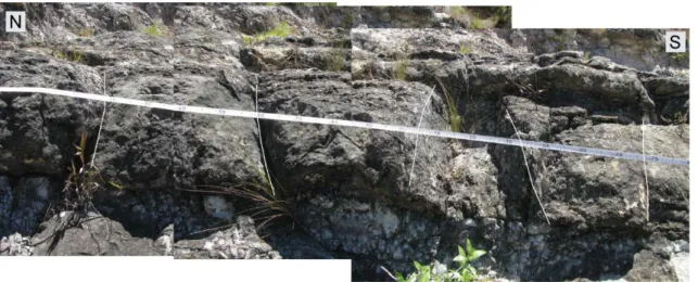
As a whole, the sedimentary succession cropping out along the backlimb strikes N-S, dipping about 40° to the W. The analysed structures include generic fractures, shear fractures, veins and tectonic stylolites representing a spaced disjunctive cleavage produced by pressure solution.
Generic fractures occur in all the mechanical units exposed along the backlimb of the anticline. Poles to generic fractures show four main directions both in their present orientation and after bed rotation: N-S, E-W, NNW-SSE, ENE-WSW and WNW-ESE (Fig. 3.2a, b).
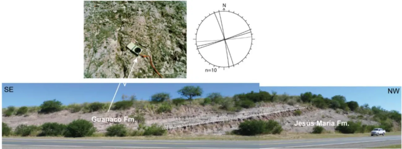
N-S fractures are dominant and well visible in all the outcrops, and have generally high angle of dip (80°). They occur also in the younger strata (Jesús María Fm.) with a constant spacing of about 30cm and a length greater than 2m; the aperture is from few millimiters up to 1.5cm.
E-W fractures occur in the strata of Yacoraite Formation and Pirgua Subgroup, in the area of Anta Yaco and Ceibal; they show a constant spacing of about 30cm; their length varies from 30 cm to several metres and the aperture is mostly lower than 1mm, but in some cases it reach a value of 3mm such as in the strata of Yacoraite Formation (Fig. 3.3).
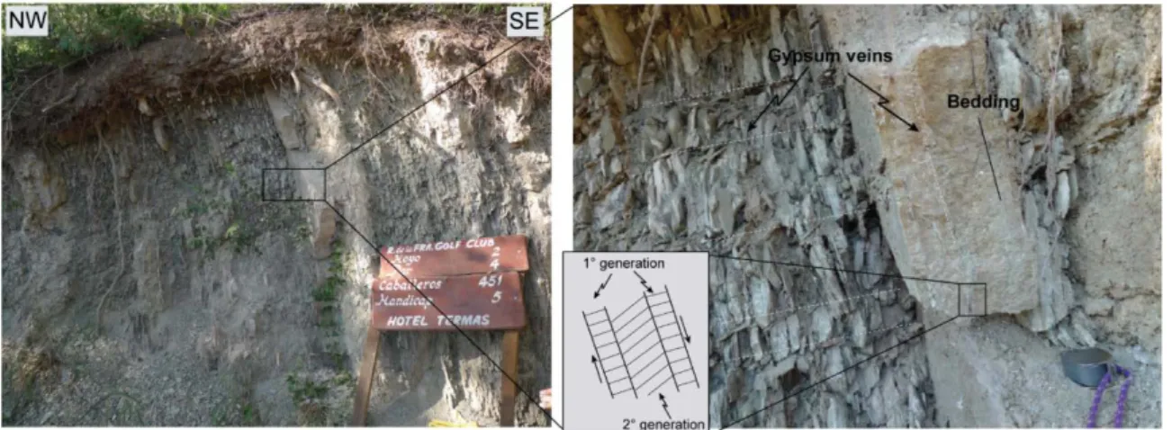
NNW-SSE and WNW-ESE striking fractures, with high angle of dip, occur mainly in the strata of Medina and Pirgua Formations in the area of Anta Yaco. ENE-WSW generic fractures characterized mainly the strata of Pirgua Subgroup in the Ceibal area. In this latter area, calcite-filled veins are dominant in systematic sets striking along ENE-WSW and NNE-SSW directions (Fig. 3.4a).
They show a variable spacing ranging from several metres down to 30-40cm; their thickness ranges from few millimiters to 2cm.
Fig. 3.2 – Stereographic projections (Schmidt net, lower hemisphere) of the structural data collected in the
(a) Anta Yaco and (b) Ceibal areas, (c) Balboa and (d) Termas anticlines.
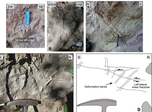
Shear fractures were recognized in the strata of Anta and Pirgua Formations in the area of Anta Yaco. In the Anta Formation, they occur as conjugate strike-slip systems striking NNW-SSE and E-W, steeply dipping and mutually cross cutting, probably related to a contraction parallel to bedding dip (Fig. 3.4b). On the contrary, the strata of Pirgua Subgroup show a pervasive deformation characterized by E-W shear fractures with a right-lateral component of motion and a constant spacing of about 30cm (Fig. 3.4c); they are in accordance with the ESE shortening Andean direction (Marrett et al., 1994). WNW-ESE left-lateral shear fractures also occur in these deposits. They occur with a low frequency and a length of about 80cm.
Fig. 3.3 – E-W fractures in the strata of Yacoraite Formation in the area of Anta Yaco
Stylolites trending N-S were observed in the strata of Yacoraite Formation (Fig. 3.4d). They occur normal to bedding and are interpreted as contractional structures.
Although the cross cutting relationship are not always consistent, N-S fractures are considered the younger one, because of their occurrence in the younger strata.
3.2.2 Northeast nose of Balboa anticline
Fractures data were collected from this portion of the anticline in the area of Balboa anticline, from the sandstones of Pirgua Subgroup (Fig. 3.2c). In this area, bedding strike rotates from N75°W to N20°W, as a consequence of the shape of the Balboa anticline (Fig. 3.1).
Generic fractures, veins and deformation bands occur in the area. Poles to generic fractures are clustered around two broad maxima corresponding roughly to NNE-SSW and NNW-SSE trends, both in the rotated and unrotated analysis. These fractures are