ORIGINAL ARTICLE
The History of the Southern Apennines of Italy Preserved
in the Geosites Along a Geological Itinerary in the High Agri Valley
Francesco Bucci1 &Enrico Tavarnelli2&Rocco Novellino2&Giuseppe Palladino3&Paola Guglielmi3& Salvatore Laurita3&Giacomo Prosser3&Mario Bentivenga3Received: 17 December 2018 / Accepted: 20 June 2019
# The European Association for Conservation of the Geological Heritage 2019
Abstract
The itinerary presented in this paper links several geosites and proposes a series of geostructural and geomorphological observations that illustrate the cyclical character of the orogenic processes. The itinerary crosses the northern corner of the High Agri Valley, a 200-km2-wide area of outstanding geological importance located along the axial sector of the Southern Apennine of Italy. Its history is the result of the succession of extensional and contractional deformation phases that allowed the deposition of sediments, the formation and deformation of rocks, the growth and the fragmentation of an orogenic system during the last 250 MA. The aim of the study is to bridge scientific and educational values of the High Agri Valley area by examining its geological and geomorphological features, which have been fundamental in shaping the landscape, and determining the geological resources and the natural hazards, highlighted through the itinerary. Despite its outstanding natural beauty, over the years, the investigated area has suffered the pressure of diverse human activities, including a growing industrial development related to hydrocarbon exploration and production, often leading to conflicting interests and severe landscape damage. As a result, environmental and geoconservation aspects of this area have been at the centre of regional and national debates. In the light of these issues, this work aims at providing a better understanding of the geological and geomorphological value of the High Agri Valley area, in order to strengthen the basis for setting-up a sustainable geoconservation plan, which includes geotourism issues.
Keywords Inversion tectonics . Structural geology . Geomorphology . Natural hazards . Georesources
Introduction
The deformation history of mountain belts is characterised by alternating pulses of extension and contraction modulated through time according to a sequence known amongst geolo-gists as the“Wilson cycle”. In these settings, extensional
structures produced during episodes of pre-orogenic continen-tal rifting and/or ocean opening are systematically overprinted by folding and thrusting developed during orogenic accretion or continental collision. The reverse is also common during more advanced evolutionary stages, when orogenic folds and thrusts are truncated and modified by the development of extensional structures produced during late- or post-orogenic extensional col-lapse (Wilson1961; Dewey and Bird1970). This cyclical repe-tition of kinematically alternating deformation events is recognised in fossil as well as in active orogenic domains, so that the evolution of a mountain belt can be reasonably predicted, at least to a certain extent, in terms of relatively simple models (Gutirrez-Alonso et al.2008).
The history of complete orogenic cycles is well recorded in the Southern Apennines fold-and-thrust belt of Italy and is generally inferred from numerous observations carried out at different localities scattered over wide areas, at regional scale. On the other hand, the documentation of repeated processes of inversion tectonics is rarely preserved in the same portion of a mountain chain, at local scale.
This article is part of the Topical Collection on Geoheritage: the foundation for sustainable geotourism
* Francesco Bucci [email protected]
1
Consiglio Nazionale delle Ricerche, Istituto di Ricerca per la Protezione Idrogeologica, Via Madonna Alta 126,
I-06128 Perugia, Italy
2
Dipartimento di Scienze Fisiche, della Terra e dell’Ambiente, Università degli Studi di Siena, Via Laterina 8, I-53100 Siena, Italy
3 Dipartimento di Scienze, Università degli Studi della Basilicata, Via
Ateneo Lucano 10, I-85100 Potenza, Italy
In this study, we identify the High Agri Valley (Fig.1), in the central part of Lucanian Apennine, as a key area to study in detail the structural geology of each stage that characterises the life and tectonic history of a collisional mountain belt. We present an itinerary through the High Agri Valley aiming at illustrating its entire deformation record, focusing on multiscale geological structures representative of pre-, sin- and post-orogenic tectonic episodes. The geological sites of the itinerary were selected based on their scientific relevance. As a matter of fact, most of these represent case studies widely published in international geosci-ence journals. At the same time, the geological itinerary is de-signed in a spectacular scenery, mostly encompassed within the Appennino lucano val d’Agri Lagonegrese National Park, pro-viding the opportunity to bridge scientific and cultural interest of the High Agri Valley, by examining its geological and structural features, which have been fundamental in determining its beauty, its vulnerability to natural hazards and its richness in geological resources (Bentivenga et al.2017; Palladino et al.2013).
Study Area
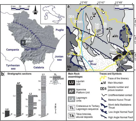
The study area extends between 40° 20′ and 40° 29′ N, and 15° 43′ and 15° 52′ E (Fig.1) in Southern Italy. It encompasses the NW–SE trending High Agri Valley, which is bounded to the
northeast by the rough peaks of the Mt. Volturino - Il Monte di Viggiano range, reaching elevation of up to 1800 m a.s.l. (Fig. 1a). To the southwest, the Monti della Maddalena range separates the High Agri Valley from the Vallo di Diano basin to the west (Fig.1a). The regional water divide runs along the Monti della Maddalena range. The High Agri Valley is axially drained by the Agri river, which flows 100 km eastwards into the Ionian Sea.
The NW–SE trending structural depression of the High Agri Valley is filled by Quaternary continental deposits that cover complex assemblages of pre-Quaternary sedimentary rocks (Fig.1a, b) comprising Mesozoic to Cenozoic platform limestone deposited on top of Upper Triassic dolomite of the Apennine platform domain (Bonardi et al. 1988; Palladino et al.2008). Clay and sandstone deposited in deep sea condi-tions (Liguride and Sicilide units; Cavalcante et al. 2012; Bonardi et al. 1988) tectonically overlie carbonate rocks of the Apennine platform domain, which in turn were thrust on top of coeval pelagic rocks of the Lagonegro domain (Cavalcante et al. 2011), and on younger Miocene synorogenic siliciclastic sediments (Pescatore et al. 1999, and references therein). The Lagonegro units tectonically overlie a 6–7-km-thick sequence of Mesozoic to Tertiary car-bonates and Pliocene siliciclastic rocks that represent the west-ward continuation of the Apulia foreland. Between the Apulia carbonate rocks and the overlying Lagonegro units, a
1.5-km-Fig. 1 Shaded relief for the Lucanian Apennines, Italy, with location of the High Agri Valley (inset (A)). a Geological sketch map of the High Agri Valley, with the geotouristic itinerary proposed in this study (in yellow) and the location of the geosites (1–12) described in the text. b Schematic stratigraphic columns of the main tectonic units copping out in the High Agri Valley. Af, Argille Varicolori and Flysch Rosso formations (late Cretaceous to Oligocene); AP, Apennine platform unit; CJl, Cretaceous and Jurassic limestone; Cs, Calcari Con Selce Formation (Late Triassic); Ga, Galestri Formation (Cretaceous); MF, Monte Facito Formation (Middle to Late Triassic); L1, Lagonegro I unit; L2, Lagonegro II unit; LU, Ligurian unit; OM, late Oligocene to Miocene sediments; Os, Oligocene shale and siltstone; Sm, Sorgente dell’Acero Member (Carnian); Ss, Scisti silicei (Jurassic); Td, Triassic dolomite; TL, Cretaceous to Tertiary Lagonegro sequence
thick mélange zone, consisting mainly of over-pressurized siliciclastic sediments of Miocene age (Butler et al.2004), acts as a seal for oil reservoirs hosted in the buried Apulia carbonates.
The main tectonic contacts between the Apennine platform and the Lagonegro domains are exposed in the relief bounding the High Agri Valley. In the northern sector, the Marsico Nuovo thrust, a regional low-angle tectonic contact, dupli-cates rocks of the Lagonegro domain into two distinct tectonic units, the Lagonegro I unit below and the Lagonegro II unit above. In the western sector, the Lagonegro II unit is tecton-ically overridden by the Apennine platform rocks that crop out on the Monti della Maddalena ridge along the low-angle Monti della Maddalena thrust (Fig.1a, b). In the central sector, the Monti della Maddalena Thrust and Marsico Nuovo Thrust were eroded on the Monte Lama and Monte Volturino ridge, where two main anticlines, the Monte Lama Anticline and Monte Volturino Anticline, separated by the Monte Volturino Syncline, are magnificently exposed. Both anti-clines exhibit a distinct axial culmination and expose the deeper parts of the Lagonegro I unit (Scandone1972; Bucci et al. 2012). In the eastern sector, scattered outcrops of Apennine Platform rocks (mainly limestone), and rocks of the Lagonegro II unit, are present along a low-angle tectonic contact, above the rocks of Lagonegro I Unit.
The abovementioned contractional architecture, related to the Late Oligocene–Early Miocene continental collision, was strongly modified by post-orogenic extensional tectonics, which resulted in a typical basin-and-range morphology, char-acterized by distinctive landform types, including horsts, gra-bens and related slopes. The High Agri Valley is a fault-bounded intermountain basin that formed during the Quaternary in response to transtensional/extensional tectonics that dissected pre-existing Neogene folds and thrust structures of the Southern Apennines range (e.g. Tavarnelli and Pasqui 1998,2000). The extensional tectonic regime is still active in the area and is responsible for the occurrence of strong histor-ical earthquakes (Burrato and Valensise2008).
The Itinerary
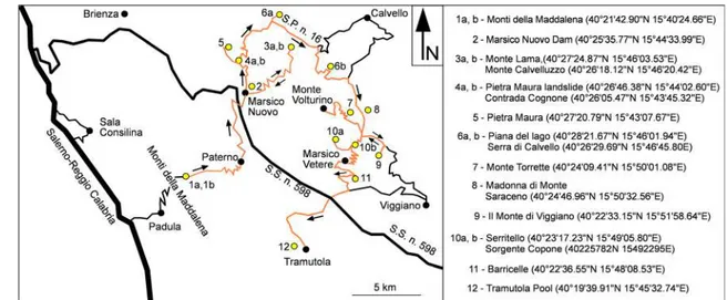
The geological itinerary includes 17 stops at as many geosites that can be reached through secondary roads, easily travelling by car (Fig.2). The first seven stops (1a, 1b, 2, 3a, 3b, 4a, 4b) are designed to illustrate the contractional architecture of the Apennine tectonic pile through the presentation of regionally significant structures and associated meso-scale deformations. The subsequent ten stops focus on the effects of ancient (stops 5, 6a, 6b) and recent (stops 7, 8, 9, 10a, 10b, 11, 12) exten-sional deformations, illustrating the double switch in tectonic regime, from pre-orogenic drifting (through sin-orogenic thrusting) to post-orogenic extension. Each of the selected
geosites contains multidisciplinary geological information, and when combined together provide an integrated view on the stratigraphy, the structural geology and the geomorpholo-gy of the High Agri Valley and surrounding ridges. In addi-tion, and perhaps more significant, the stops illustrated along the proposed itinerary are relevant in that, collectively, help outline the main deformation episodes that led to the forma-tion and then to the dissecforma-tion of the Southern Apennines orogenic belt; therefore, they can be regarded as representative of the geological history of an important sector of Southern Italy.
In the forthcoming sections, we describe the main features of each site of geological interest where the effects of orogenic contractional deformations are observed. A description of the sites of geological interest where effects of pre-orogenic and post-orogenic extension are visible will follow.
Contractional Tectonics
Monti della Maddalena Thrust (Stops 1a and 1b—View Points Along the SP273)
Location and Aim The stop is located along the road SP273 Paterno-Mandrano that connects the High Agri Valley with the Vallo di Diano basin passing through the Mandrano plain on top of the Maddalena mountain range. This road intercepts the regional tectonic contact between the Mesozoic–Cenozoic platform and slope carbonates of the Monti della Maddalena unit, which overthrusts coeval pelagic rocks of the Lagonegro units. The analysis of the thrust represents the outcrop-scale focus of the stops. In addition, the stop 1b offers a spectacular view of the High Agri Valley, of both valley shoulders and of the alluvial plain, and offers a panoramic overview of most of the other stops located along the itinerary. For this reason, this stop provides an excellent opportunity for an introductory overview of the geology, geomorphology and tectonics of the High Agri Valley.
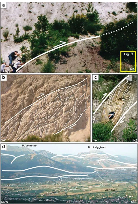
Outcrop Description The stop 1a offers detailed view of the tectonic fabric associated with the regionally important Monti della Maddalena thrust (Fig. 3a). Along this thrust, intense shearing produced a brittle–ductile contractional shear zone that extends for tens of metres in the hanging wall, where it affects chiefly white Upper Triassic dolomite and subordinate-ly Liassic limestone of the Apennine Platform unit (Fig.3b). In the footwall of the Monti della Maddalena thrust, rocks of the Lagonegro units are also intensely deformed (Fig.3c). The fault zone of the Monti della Maddalena thrust can be subdivided into three main domains, characterised by different fabrics and deformation features: (1) the footwall, (2) the fault zone, (3) the hanging wall. The main structures in the footwall rocks are represented by decimetre- to metre-size, ENE-verging asymmetric folds and associated cleavage fabrics.
Near the thrust plane, where the largest deformation was ac-commodated, detached asymmetric folds are also present. WSW dipping reverse faults with metre-size displacements are also present. S–C shear fabrics are abundant in the footwall and are locally associated with synthetic, outcrop-scale faults that may be interpreted as C′ shear surfaces. The fault zone consists of up to 3 m of fault gouge. The gouge contains highly disrupted, millimetre- to centimetre-size fragments of limestone and dolomite of the hanging wall. A highly disrupted level is present close to the main slip surface. The level contains brown to red, marly limestone embedded in a deformed shale matrix derived from the shearing of the foot-wall rock materials. In the hanging foot-wall, intensively fractured rocks affected by reverse faults and shear fabrics, including Riedel shear surfaces, characterise the deformation zone. The different structures and fabrics observed and measured in the three deformation domains are consistent with a single shear sense and are indicative of an ENE direction of movement. This is consistent with the regional tectonic setting and defor-mation history (Bucci et al. 2014). Several post-orogenic faults cut across the thrust assemblage. The effects of these post-orogenic faults are revealed from the multiple dislocation of the thrust contact, which is outlined by the strong colour contrast between the withe cataclastic carbonate of the hang-ing wall and the brownish terrigenous sediment of the foot-wall. The same post-orogenic faults make deca-metric mor-phologic steps in the slope, which are travelled downhill by the steep winding road linking the stop 1a to Paterno village. Between the stop 1a and Paterno village, the road intercepts the down-faulted thrust contact at stop 1b, where a population of meso-scale reverse faults combines locally to form complex thrust systems, imbricate fans or duplexes, in the cataclastic rocks of the hanging wall (Fig.3b). Here, the fault planes are represented by mirror-like striated fault surfaces. In addition, the stop 1b offers a scenic view of the eastern flank of the High Agri Valley, where the itinerary is designed (Fig.3d). There,
rocks of the Lagonegro I units display ~N-S to NW-SE trending major folds (e.g. the Monte Lama and Monte Volturino folds) and are replaced toward NW by the rocks of the Lagonegro II unit along the NNE-SSW trending Marsico Nuovo thrust. Still observed from this stop, looking toward SE in panoramic view, rocks of the Apennine Platform unit con-stitute the carbonate massif of Il Monte di Viggiano. The val-ley flank displays a rectilinear trend of the mountain front, which is characterised by a mature staircase profile sloping toward the valley, generated by post-orogenic faulting (Fig. 3d). This mountain front is punctuated by two prominent al-luvial fans, generated by the Molinara and Galaino creeks, which force the Agri river to flow close to the west side of the valley, in asymmetric position with respect to its axial sector.
Mt. Lama–Mt. Calvelluzzo Anticline (Stop 2—Marsico Nuovo Dam)
Location and Aim The stop is located at the northern end of the Marsico Nuovo village, along the SP16. Aim of this stop is to illustrate, from a panoramic scenic viewpoint, the geometry of a prominent, map-scale anticline in Lagonegro rocks and to discuss the nature of its western flank exposed along the Monte Lama-Monte Calvelluzzo ridge.
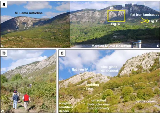
Outcrop Description This stop offers a magnificent frontal view of one of the most impressive landforms of the High Agri Valley, namely the pentagonal facets of Monte Lama– Monte Calvelluzzo (Fig.4a). These landforms have long been known and shown to researchers and students to represent a remarkable example of flat irons, developed upon steeply dip-ping beds of the Upper Triassic Calcari con Selce Fm. The tilted beds form the western limb of the Monte Lama–Monte Calvelluzzo anticline, a prominent N-trending fault-related structure in the Lagonegro thrust system (Mazzoli et al.
2001). The Monte Lama–Monte Calvelluzzo Anticline in-volves the Mesozoic succession of the Lagonegro I unit (Scandone1972) or San Nicola unit (Mazzoli et al. 2001), and exposes the Upper Triassic Calcari con Selce Fm. in the core and the Jurassic Scisti Silicei Fm. in its limbs. The mor-phologic depression ringing the structure is floored by the Cretaceous Galestri Fm. The structure consists of a more than 8-km-long box fold with a marked northern plunge. The
anticline shows a vertical western limb and a steep to overturned eastern limb, both offset by minor out-of-limb thrusts, and a double vergence of associated fold structures (Bucci et al.2013). From this stop, the geometry of the fold can be clearly seen at Monte Lama along the flank of a lateral incision of the uppermost Agri river course (Fig.4a). In spite of a good understanding of the thrust structure achieved in recent work, the tilted depositional contact between Calcari
Fig. 3 Deformation structures in the Monti della Maddalena geosite (stops 1a and 1b). a The Monti della Maddalena thrust, along which carbonates of the Campano-Lucania platform unit override pelagic sediments of the Lagonegro II unit. b Mesoscopic deformation fabrics along the Monti della Maddalena thrust affecting platform carbonates in its hanging wall. c Mesoscopic folds in the footwall of the Monti della Maddalena thrust. d Panoramic view across the High Agri Valley toward its eastern flank. The Mt. Volturino-Mt. di Viggiano ridge, corresponding to the NE edge of the High Agri Valley, consists of a post-orogenic extensional fault system outlined by a mature staircase profile sloping toward the valley. Two main alluvial fans, generated by the Molinara and Galaino creeks, are also observed
con Selce and Scisti Silicei has been represented in several papers and maps as a W-dipping fault, interpreted as a mani-festation of the seismogenic tectonics of Quaternary age (Carbone et al.1991; Pescatore et al.1999). Benedetti et al. (1998) and Papanikolaou and Roberts (2007) propose that the mountain slope represents a 250-m-high Pleistocene fault-controlled escarpment, and claim that evidence for active faulting is present at the foot of the slope. More recent work, however (Bucci et al.2007; Bucci et al.2013), does not con-firm evidence for a Quaternary fault at this mountain front; moreover, these authors document that a map-scale normal fault preserved in the crest of the present-day anticline is of Jurassic, e.g. pre-orogenic, rather than of Quaternary, e.g. post-orogenic, age (Bucci et al.2006). Additional details about this inherited Mesozoic fault will be discussed in the description of the stop nos. 6a and 6b (see section“The Serra di Calvello Fault (Stops 6a and 6b—Laghetto Plain and Serra di Calvello)”).
The Mt. Lama–Mt. Calvelluzzo Flatiron and the Lagonegro I Unit (Stops 3a and 3b—Camporeale)
Location and Aim On the west flank of Mt. Lama–Mt. Calvelluzzo ridge, a light stroll will bring us at the base of the pentagonal facets presented in the previous stop. This will allow checking the nature of the pentagonal facets and discussing the debated evidence for active faulting.
Outcrop Description From the hamlet of Camporeale, east of Marsico Nuovo, we have firstly a lateral view of the pentag-onal facets (stop 3a, Fig.4b). The main slope is formed by
steeply (~ 50°–60 °) W-dipping limestones of the Calcari con Selce and the piedmont is floored by more erodible Scisti Silicei radiolarian argillites. The facets are separated by perched, “wine glass” canyons (Fig. 4b), which have been regarded as evidence for active faulting and footwall uplift (Benedetti et al.1998). The knick-point is located at a marked lithological change from more erodible argillites to well-bedded limestone. In addition, the facets do not cut the bed-ding but form a bed-parallel envelope. At the base of the facet, the slope dips ~ 50°–60° being developed on single beds. Thus, a flat iron nature of the facets seems plausible, with the “wine glasses” being controlled by lithology. From the car stop, the trail leads to the north on gentle ground underlain by argillites of the Galestri Fm. The Galestri is highly incised and thus no subsidence (as expected in the hanging wall of a normal fault) is documented at this site. A first, some 10-m-high step occurs downhill the mountain slope at the litholog-ical transition between radiolarite and limestone of the Scisti Silicei and more erodible argillites of the Galestri. Locally, asymmetric mesoscopic folds related either to parasitic fold-ing (Z-type) or to out-of-limb shearfold-ing expose gently basinward-dipping beds. These outcrop-scale structures form 1–2-m-high scarplets which are laterally discontinuous and locally promote minor landslides. Further high, the Calcari con Selce limestones are affected by sub-horizontal or gently E-dipping fractures, which are thus almost orthogonal to bed-ding. The angular relations between beds and fractures can be interpreted as a result of wholesale tilting of beds and fabrics that was formed when beds were horizontal, i.e. before the folding event of Neogene age. Alternatively, the fractures or-thogonal to bedding could develop later during the fold
Fig. 4 The Mt. Lama-Mt. Calvelluzzo anticline (stop 2). a Panoramic view of the Mt. Lama-Mt. Calvelluzzo anticline from the Marsico Nuovo dam. The SW flank of Mt. Calvelluzzo is outlined by a prominent flat iron landscape, where flat iron structures I–IV are observed (see text for explanation). b Along-strike view of the flat iron-dominated landscape. c Detail of the wine glass rill channel between flat irons III and IV, where the contact between the bedrock and the roughly stratified debris is well exposed
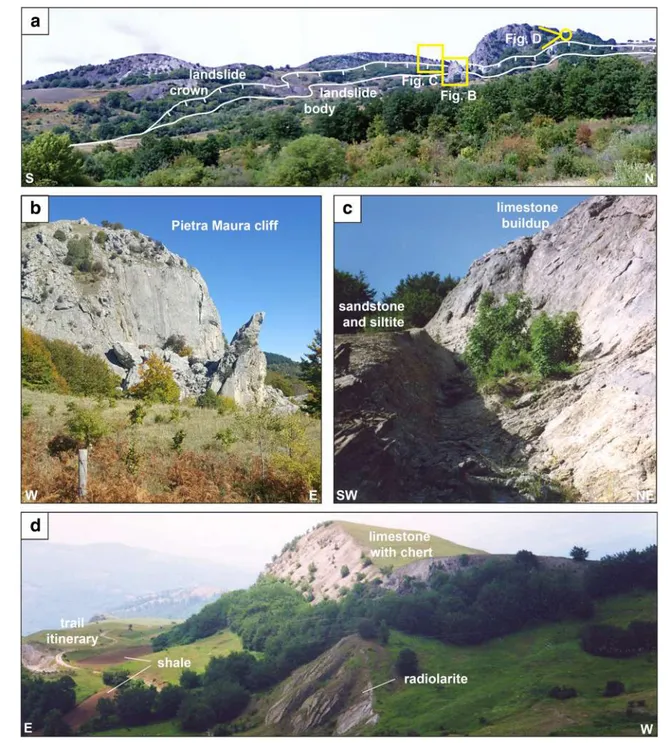
growth process, when the beds were already inclined. However, independently from their origin, the fractures are not affected by movements along bedding planes, suggesting that bedding-parallel slip did not occur in the area after the Neogene compressive events (Bucci et al.2013). Conversely, no evidence for basinward-dipping fractures forming the dam-age zone of a recent normal fault, invoked by Benedetti et al. (1998), is observed. The trail finally reaches a gully at the base of the fourth facet (counting from S to N). Here (stop 3b), crudely bedded loose debris has been deposited at the mouth of the gully and is unconformably lying on a tilted limestone bed (Fig.4c). The fan deposit is, itself, incised for a height of 3–4 m. The upper surface of the fan deposit continues into the bedrock until the thicker limestone of the facet is reached. The ~ 45° dipping surface is probably an erosional glacis formed during the last glaciation and subsequently incised. No evi-dence of faulting of the deposit and of the glacis is found at this site. In summary, the available evidence that can be ob-served at this site rules out the hypothesis of a Quaternary, large-displacement normal fault at this mountain front. The Marsico Nuovo Thrust and the Pietra Maura Landslide (Stops 4a and 4b—Contrada Cognone)
Location and Aim The stop 4 is located along the road SP16, a few kilometres north of Marsico Nuovo village. This road intercepts the regional tectonic contact between the Triassic limestone, shale and sandstone terrains of the Monte Facito Formation, pertaining to the Lagonegro II unit, which are thrust over Cretaceous pelagic rocks of the Galestri Formation, pertaining to the Lagonegro I unit. The stops 4a and 4b expose the Lagonegro terrains along a regionally im-portant thrust contact, here named Marsico Nuovo Thrust, and illustrate the role of the thrust architecture in controlling the location and evolution of a large landslide.
Outcrop Description The position of the Marsico Nuovo Thrust is poorly constrained because of the tectonic superpo-sition of shale-dominated terrains that are present in the hang-ing wall (Monte Facito Formation of the Lagonegro II unit) and in the footwall (Galestri Formation of the Lagonegro I unit). According to the local geological cartography, the thrust contact separates the chaotic terrain of the hanging wall block and the thrust zone, from the thin-layered shale and subordi-nated calcilutite of the footwall. Beside, east of the stop 4a, the terrain appears chaotic in general, for a length in plane view (measured along the road) of about 400 m, that doubles up to 800 m if measured along the road, approaching the stop 4b. The zone of chaotic terrains is bounded by two streams, which result pushed far from each other toward lateral ridges. The stream drains a wide area upstream, which is characterised by a generalised hummocky topography, and locally by counterslope areas and periodically humid zones. Overall,
the evidence is associated with a large landslide (Fig. 5a), namely the Pietra Maura landslide (Bentivenga et al. 2012). In plane view, the Pietra Maura landslide shows a NW-SE-oriented elongated shape with a large depletion zone (up-stream of the stop 4) and a narrow channel (stop 4). The stop 4b provides a quite complete view of the Pietra Maura land-slide, showing also its wide toe which deflects the Agri river and partially interacts with the Marsico Nuovo Dam. At the moment, the activity of the landslide seems to be mainly re-stricted to the depletion area and to a lesser extent to the lateral channel streams, while the resting part is dormant. Comparative analysis of landslide and geological maps re-veals that the Pietra Maura landslide developed along the thrust zone. The landslide involves mainly weak rocks of Galestri (at the thrust footwall) and Monte Facito formations (at the hanging wall) and subordinately involves limestones pertaining to the overthrust block. The landslide is classified as a complex slide-earthflow and is characterised by an upper portion subject to multiple and compound slides (Fig.5a) and rockfall and toppling phenomena (Fig.5b), and a medium to lower part with a primary flow component. Instability condi-tions that lead to such failure can be attributed to the poor geomechanical behaviour of the sheared rock mass cut by numerous, closely spaced discontinuities (Bucci et al.2016a, b) and to the peculiar hydrogeological setting due to the tec-tonic superposition of platform limestone, radiolarite and mi-caceous sandstones of the Monte Facito Formation over pre-dominant marl and shale of the Galestri Formation.
Pre-orogenic Extensional Tectonics
The Monte Facito Formation and the Signature of Syn-depositional Tectonics (Stop 5—Pietra Maura) Location and Aim From Contrada Cognone, the itinerary de-parts from the ordinary road, and it climbs up along a second-ary road to the Pietra Maura location (stop 5). The stop 5 aims at illustrating the rocks of the hanging wall of the Marsico Nuovo thrust and in particular focuses on the stratigraphy of the Monte Facito Formation (Scandone1967).
Outcrop Description Several outcrops along the secondary road connecting Contrada Cognone to Pietra Maura (stop 5) illustrate the most significant litho-stratigraphic members of the Monte Facito Formation. This shows a very heterogeneous lithologic content that is mainly represented by variable amounts of sandstones, shales, radiolarites, marls and lime-stones and that reflects drastic environmental changes during deposition (Palladino et al. 2019). The lower portion of the sequence consists of some metres of tabular-shaped neritic limestone bodies predominantly made up of Dasycladales and Solenoporacean algae (Fig.5b). Other associated faunas are represented by sponges, isolated corals, rare ammonites,
gastropods, crinoids and benthonic foraminifers. Neritic lime-stones are stratigraphically covered by nodular calcareous brec-cias and siliciclastic sandstone and siltites (Fig.5c). This interval marks the onset of subsidence and the sudden drowning of neritic limestones. Upward, lens-shaped brachiopod-rich calcarenite bodies interlayered with sandstones are interpreted as tentative re-colonization of the sandy substratum in a shallow water ter-rigenous environment. These levels have provided an abundant brachiopod fauna represented by Puncospirella fragilis and
Anisactinella maurensis species (Bentivenga and Palladino 2013). In the same stratigraphic interval, micaceous sandstones with wave ripple marks are interpreted as a well-preserved Triassic submerged beach. Upward, radiolarites and marls with carbonate breccias and carbonate bodies testify the complete drowning of carbonate buildup elements, which anticipate the deposition of limestones with chert (Fig.5d). The succession of these members, resulting in the sudden switch from shallow to deepwater deposits, reflects the Triassic tectonic evolution of the
Fig. 5 The Marsico Nuovo thrust and the Pietra Maura landslide (stops 4a and 4b) as seen from Contrada Cognone. a Panoramic view of the crown area and the depletion zone of the Pietra Maura landslide. b The Pietra Maura cliff. c Detail of the Pietra Maura carbonate buildup,
stratigraphically covered by sandstone and siltite of the Middle Triassic Monte Facito Fm. d View of the limestone with chert ridge, stratigraphically underline by radiolarites and shales of the Middle Triassic Monte Facito Fm
Lagonegro basin that experienced an ongoing rifting process. The tectonic subsidence and the consequence stratigraphic evo-lution of the Monte Facito Formation was related to the sin-sedimentary extensional tectonics affecting the Lagonegro basin during the middle Triassic time (230 MA), in the framework of the progressive Africa-Europe continental separation, and subse-quent opening of the Neotethys Ocean.
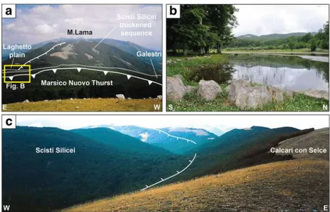
The Serra di Calvello Fault (Stops 6a and 6b—Laghetto Plain and Serra di Calvello)
Location and Aim The stop is located along the road SP16, in correspondence to the Laghetto plain and to the morphologic saddle between Monte Arioso and Monte Lama. The Laghetto plain hosts a seasonal small lake and is mainly filled by a thin continental deposit. The Laghetto plain is floored by the Galestri Formation that rings the periclinal termination of the Monte Lama anticlinal ridge and disappears northward under the Marsico Nuovo Thrust. Aim of this stop is to illustrate the diagnostic elements of a pre-orogenic extensional fault and to discuss its structural control during positive inversion tecton-ics (from pre-orogenic extension to syn-orogenic contraction). Outcrop Description The effects of pre-orogenic extension are preserved at the northern termination of the Monte Lama anti-cline, a major map-scale fold involving the sedimentary succes-sion of the Lagonegro I unit (Fig.6a). In the eastern limb of the anticline, the Jurassic Scisti Silicei Formation is thin (40–50 m), whereas in the western limb, the same formation is much thicker (100–150 m) and contains abundant slumping structures, an in-dication of intense seafloor mobility during deposition. These thickness variation in the Scisti Silicei are controlled by a major, Km-scale sin-sedimentary, pre-orogenic normal fault. The fault is sealed by the Cretaceous, post-rift sequence of the Galestri Formation, outcropping in the north side of the Laghetto plain
(Fig.6a, b). These relationships make it possible to unequivocal-ly ascribe the normal fault activity to Jurassic time. During the Neogene orogenic event, this structure controlled the develop-ment of the Monte Lama fold in terms of orientation and thrust ramp location as revealed by the sub-parallel attitude of the Monte Lama anticline and the Jurassic fault. However, the map pattern at the northern termination of the Monte Lama anticline displays a continuous stratigraphic contact between the Galestri and Scisti Silicei that seals the Jurassic normal fault. Thus, no significant evidence for fault reactivation during positive tectonic inversion was observed at this site (Bucci et al.2006). The strains produced during the Tertiary episodes of positive tectonic inver-sion were thus accommodated by mechanisms alternative with respect to the classical fault-reactivation style; these include buttressing effects, folding and wedge-type (or shortcut) thrusting (Butler1987), which progressively modified the pre-existing nor-mal faults. The south side of the Laghetto plain is characterised by the presence of a seasonal small lake (Fig.6b). The lake is fed by an ephemeral water course flowing in a valley developed at the top of the Mt. Lama and Serra di Calvello anticlinal ridge, and trending parallel to the anticline axis. In spite of the locally poor exposure conditions, it seems probable that the valley hosts a relict of the pre-orogenic normal fault (Fig.6c). The valley de-velops at the faulted contact between the Scisti Silicei and the Calcari con Selce formations, where differential erosion of intact bedrock and fractured rocks of the fault zone is expected. The evidence of the inherited normal fault preserved at the top of the Mt. Lama anticline is in good agreement with many natural and analogue examples that show major pre-orogenic faults control-ling the nucleation and growth of anticlinal structures. Overall, these evidences confirm earlier interpretations of the Lagonegro basin as a domain that recorded a long and complex syn-rift evolution, similarly to other Mesozoic basins of the Adria Palaeo-margin (Karakitsios1995). During the Mesozoic, intense extensional tectonics caused the deepening of the basin and the
Fig. 6 The Serra di Calvello fault (stops 6a and 6b). a Near along-strike panoramic view of the Serra di Calvello pre-orogenic normal fault (see text for explanation). b The Laghetto lake and its surrounding plain. c Along-strike view of the Serra di Calvello pre-orogenic normal fault that separates the Jurassic Scisti Silicei Fm. in its hanging wall, from the Upper Triassic Calcari con Selce Fm. in its footwall
differentiation into an intermediate and a distal stratigraphic suc-cession in a W-E direction. The overall basin architecture, at least during the Jurassic time interval, probably consisted in fault-bounded highs and depressions (roughly elongated with N-S trend in present-day coordinates) hosting syn-rift sequences characterised by different facies and thickness.
Post-orogenic Extensional Tectonics
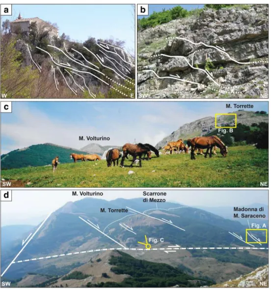
East-Dipping Low-Angle Tectonic Contacts (Stops 7 and 8—Madonna di Monte Saraceno and Monte Torrette) Location and Aim The stops are located on the east flank of the Mt. Volturino ridge, in proximity of the SP16. Coming from the north, a light stroll departing from the main road leads to the stop 7, corresponding to the base of the carbonate relief on whose top is located in the Madonna di Monte Saraceno church. A visit to this site makes it possible to check the nature of the low-angle tectonic contact at the base of the carbonate relief. The stop 8 is located at the base of Mt. Torrette, along a secondary road linking the SP16 to the base of Monte Volturino. The stop 8 illustrates east-dipping, low-angle tec-tonic contacts affecting the sediments of the Lagonegro II unit. Outcrop Description The stop 7 coincides with the church of Madonna di Monte Saraceno, which is built on one of the several wide isolated outcrops of platform carbonates located east of the Monte Volturino ridge (Fig.7a). They represent the easternmost fringes of the Monti della Maddalena thrust sheet. These scattered outcrops of platform carbonates are generally interpreted as thrust remnants, or klippen, in the official car-tography (Servizio Geologico d’Italia1969) as well as in other geological maps (Lentini et al.1990). However, the results of recent investigations (Bucci et al.2012,2014) document east-dipping, low-angle tectonic contacts (Fig.7a) carrying out the klippen on top of deformed rocks of the Lagonegro I and II units. The low-angle tectonic contacts are locally responsible for the omission of parts of the stratigraphic sequence and for a remarkable structural truncation of bedding planes in the up-per and lower blocks. In addition, the basal tectonic contact of the klippe truncates folds, thrusts and related structures in the footwall and exhibits distinct extensional characteristics. The geometry, fabrics and deformation features differ from those observed in the rocks at the base of the frontal ramp of the thrust that crops out along the western margin of the upper Agri Valley. These relationships have been interpreted as in-dicators of the post-thrusting emplacement of the klippen by low-angle normal faults. However, kinematic indicators are poorly preserved in the footwall of the klippen, which is main-ly characterised by slivers of Oligocene–Miocene sediments associated with chaotic terrains, consisting of a highly disrupted tectonic levels where the original sedimentary fea-tures and rock fabrics are obliterated. Mesoscopic strucfea-tures
associated with basal low-angle tectonic contacts are better preserved in the rocks of the hanging wall, which will be presented in the subsequent stop 10.
In the stop 8, meso-scale east-dipping low-angle tectonic contacts are present in the Calcari con Selce Formation of the Lagonegro II unit (Fig.7b). These meso-scale structures rest at the hanging wall of a major, poorly exposed, low-angle tec-tonic contact developed within the sheared rocks of the Monte Facito Formation, at the base of a large klippe of rocks of the Lagonegro II unit, which constitutes Monte Torrette (Fig.7c). A specific structural analysis was performed at these sites (Bucci et al.2014). The analysis focused on striated, meso-scale low-angle fault planes present in the Calcari con Selce Formation and revealed that along the transport direction, the low-angle tectonic contacts cut mesoscopic folds propagating locally along mechanically favourable shale layers and are linked to steeper (40°–60°), NNW–SSE-trending normal faults in the hanging wall. In addition, fault slip kinematic data for the low-angle tectonic contacts in the Lagonegro II unit are entirely compatible with the similar kinematic data obtained for such contacts in the Apennine platform domain. We con-sider this as evidence of a common and coeval origin of the low-angle tectonic contacts in the two lithological types. Field evidence confirms the presence of at least two shallow low-angle tectonic contacts in the Monte Volturino and surround-ing areas, located at the contact between the Apennine plat-form unit and the Lagonegro II unit, and at the contact be-tween the Lagonegro I and the Lagonegro II units (Fig.7d). In this context, the deformation of the Lagonegro units that crop out at Mt. Torrette have been interpreted as the results of tilting and possibly reactivation as low-angle, foreland-directed nor-mal faults of pre-existing west-dipping thrust surfaces. The Signature of the Post-orogenic Extensional Tectonics in the Landscape (Stop 9—Il Monte di Viggiano)
Location and Aim The stop is located at the top of the Monte di Viggiano, at the end of a delightful, steep walkway starting from the parking at the end of the paved road. Along the trail, several outcrops of rudist-rich portion of Apennine platform carbonate, which are beautifully exposed, merit additional stops. The potential for conservation of these outcrops have been discussed in a recent paper, to which the reader is re-ferred for additional information (Bentivenga et al.2017). The trail stops at the sanctuary of Madonna di Viggiano offering a superb 360° view. Aim of this stop is to discuss, from a pan-oramic viewpoint, the signature of the post-orogenic exten-sional tectonics in the landscape.
Outcrop Description The Monte di Viggiano offers a pano-rama view of the southern side of the Monte Volturino. Here, the east-dipping low-angle tectonic contacts developed at the base of the Madonna di Monte Saraceno relief and of
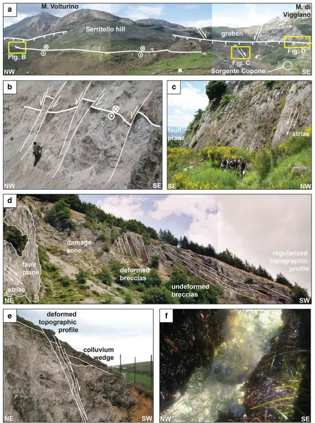
other scattered, isolated outcrops of apenninic platform rocks (Scarrone di Mezzo relief) and Lagonegro II rocks (Monte Torrette) are visible east of the Monte Volturino ridge (Fig. 7d). Toward SE, the low-angle normal faults are bounded by a right lateral strike-slip fault, whose trace coincides with the SW-NE-oriented morphologic saddle separating Monte Volturino and Monte di Viggiano (Fig.7d). A further minor relief constitute by carbonate platform rocks, named Serritello, rests west of Monte Volturino, where it overlies the Lagonegro rocks along an east-dipping low-angle normal fault, having the same attitude, and occupying the same
structural position of the low-angle normal faults detected east of the Monte Volturino ridge (Fig.8a). The low-angle normal fault abruptly stops against the steep western slope of Monte Volturino, which is clearly controlled by a high-angle normal fault, down-dipping toward the High Agri Valley (Figs.7dand 8a). The evidence suggests a common origin for the low-angle normal faults detected west and east of the Monte Volturino ridge, which formed along the same detachment zone during a first episode of extensional tectonics affecting mainly the up-per portion of the tectonic pile, and in the specific case the rocks of the Lagonegro II, and apenninic platform unit. In
Fig. 7 East-dipping low-angle tectonic contacts (stops 7 and 8— Madonna di Monte Saraceno and Monte Torrette). a Low-angle normal-fault array affecting carbonates of the Campania-Lucania platform unit at the Madonna di Monte Saraceno sanctuary. b Mesoscopic, low-angle normal fault array affecting pelagic carbonates of the Upper Triassic Calcari Con Selce Fm. (belonging to the Lagonegro II tectonic unit) along the S flank of Mt. Torrette (location indicated in c). c Panoramic view of the Mt. Volturino-Mt. Torrette ridge, with indication of the location of the mesoscopic low-angle normal fault array illustrated in detail in b. d Panoramic view of the Mt-Volturino-Mt. Torrette-Madonna di Monte Saraceno ridge illustrating the mesoscopic
and macroscopic low-angle normal fault arrays that determine the superposition of the limestone of the Campania-Lucania platform tectonic unit onto pelagic carbonates of the Lagonegro II tectonic unit (visible in the centre and in the NE side of the image). Toward the SE, the low-angle normal faults are bounded by a right-lateral strike-slip fault, whose trace coincides with the SW-NE-oriented morphologic saddle separating Monte Volturino and Monte di Viggiano. The picture also illustrates that low-angle extensional tectonic contacts are truncated by a SW-dipping, high-angle normal/extensional fault that controls the steep SW flank of Mt. Volturino. The point of view of c is also indicated
Fig. 8 Effects of post-orogenic extensional tectonics (stops 10a, 10b, 11 and 12). a Panoramic view of the Mt. Volturino-Monte di Viggiano ridge. Serritello and the Mt. Copone graben are observed. b Detail of the SW flank of Mt. Volturino, where a low-angle normal fault is truncated by high-angle mesoscopic extensional faults. c Detail of the Mt. Copone graben boundary normal fault. Slickensides exposed on the fault surface indicate dip-slip kinematics. d The high-angle High Agri Valley boundary extensional fault and associated damage zone. A detail of the fault surface indicates oblique-slip kinematics. A steeply dipping deformed breccia is
stratigraphically covered by gently to moderately dipping undeformed breccia. The contact between the deformed and the overlying undeformed breccia is overprinted by a regularized topographic profile. e Evidence for recent and/or active faulting at NE margin of the High Agri Valley. Recent high-angle faults affecting the colluvium wedge lying above the substratum determine steps in the topographic profile. f Evidence for controlled hydrocarbon upward migration at the confluence of the Torrent Fossatello and the Rio Cavolo, few hundred metres west of the Tramutola Pool