Smart City
planning far energy, transportation
an d sustainability of the urban system
TeMA
Journal of
Land Use, Mobility and
Environment
SMART CITY
PLANNING FOR ENERGY, TRANSPORTATION AND
SUSTAINABILITY OF THE URBAN SYSTEM
Special Issue, June 2014
Published by
Laboratory of Land Use Mobility and Environment
DICEA - Department of Civil, Architectural and Environmental Engineering
University of Naples "Federico II"
TeMA is realised by CAB - Center for Libraries at “Federico II” University of Naples using Open Journal System
Editor-in-chief: Rocco Papa
print ISSN 1970-9889 | on line ISSN 1970-9870
Lycence: Cancelleria del Tribunale di Napoli, n° 6 of 29/01/2008
Editorial correspondence
Laboratory of Land Use Mobility and Environment
DICEA - Department of Civil, Architectural and Environmental Engineering
University of Naples "Federico II"
Piazzale Tecchio, 80
80125 Naples
web: www.tema.unina.it
TeMA
Journal of
Land Use, Mobility and
Environment
TeMA. Journal of Land Use, Mobility and Environment offers researches, applications and contributions with a unified approach to planning and mobility and publishes original inter-disciplinary papers on the interaction of transport, land use and environment. Domains include engineering, planning, modeling, behavior, economics, geography, regional science, sociology, architecture and design, network science, and complex systems.
The Italian National Agency for the Evaluation of Universities and Research Institutes (ANVUR) classified TeMA as scientific journals in the Areas 08. TeMA has also received the Sparc Europe Seal for Open Access Journals released by Scholarly Publishing and Academic Resources Coalition (SPARC Europe) and the Directory of Open Access Journals (DOAJ). TeMA is published under a Creative Commons Attribution 3.0 License and is blind peer reviewed at least by two referees selected among high-profile scientists by their competences. TeMA has been published since 2007 and is indexed in the main bibliographical databases and it is present in the catalogues of hundreds of academic and research libraries worldwide.
EDITOR
-
IN-
CHIEFRocco Papa, Università degli Studi di Napoli Federico II, Italy
E
DITORIALA
DVISORYB
OARDLuca Bertolini, Universiteit van Amsterdam, Netherlands
Virgilio Bettini, Università Iuav di Venezia, Italy
Dino Borri, Politecnico di Bari, Italy
Enrique Calderon, Universidad Politécnica de Madrid, Spain
Roberto Camagni, Politecnico di Milano, Italy
Robert Leonardi, London School of Economics and Political Science, United Kingdom
Raffaella Nanetti, College of Urban Planning and Public Affairs, United States
Agostino Nuzzolo, Università degli Studi di Roma Tor Vergata, Italy
Rocco Papa, Università degli Studi di Napoli Federico II, Italy
E
DITORSAgostino Nuzzolo, Università degli Studi di Roma Tor Vergata, Italy
Enrique Calderon, Universidad Politécnica de Madrid, Spain
Luca Bertolini, Universiteit van Amsterdam, Netherlands
Romano Fistola, Dept. of Engineering - University of Sannio - Italy, Italy
Adriana Galderisi, Università degli Studi di Napoli Federico II, Italy
Carmela Gargiulo, Università degli Studi di Napoli Federico II, Italy
Giuseppe Mazzeo, CNR - Istituto per gli Studi sulle Società del Mediterraneo, Italy
E
DITORIAL SECRETARYRosaria Battarra, CNR - Istituto per gli Studi sulle Società del Mediterraneo, Italy
Andrea Ceudech, TeMALab, Università degli Studi di Napoli Federico II, Italy
Rosa Anna La Rocca, TeMALab, Università degli Studi di Napoli Federico II, Italy
Enrica Papa, University of Amsterdam, Netherlands
TeMA
Journal of
Land Use, Mobility and
Environment
This special issue of TeMA collects the papers presented at the 8th International Conference INPUT 2014 which will take place in Naples from 4th to 6th June. The Conference focuses on one of the central topics within the urban studies debate and combines, in a new perspective, researches concerning the relationship between innovation and management of city changing.
C
ONFERENCEC
OMMITTEEDino Borri, Polytechnic University of Bari, Italy
Arnaldo Cecchini, University of Sassari, Italy
Romano Fistola, University of Sannio, Italy
Lilli Gargiulo, University of Naples Federico II, Italy
Giuseppe B. Las Casas, University of Basilicata, Italy
Agostino Nuzzolo, University of Rome, Italy
Rocco Papa, University of Naples Federico II, Italy
Giovanni Rabino, Polytechnic University of Milan, Italy
Maurizio Tira, University of Brescia, Italy
Corrado Zoppi, University of Cagliari, Italy
S
CIENTIFICC
OMMITTEEEmanuela Abis, University of Cagliari, Italy
Nicola Bellini, Institute of Management, Scuola Superiore Sant'Anna Pisa, Italy
Mariolina Besio Dominici, University of Genoa, Italy
Ivan Blecic, University of Sassari, Italy
Dino Borri, Polytechnic University of Bari, Italy
Grazia Brunetta, Polytechnic University of Turin, Italy
Roberto Busi, University of Brescia, Italy
Domenico Camarda, Polytechnic University of Bari, Italy
Michele Campagna, University of Cagliari, Italy
Arnaldo Cecchini, University of Sassari, Italy
Donatella Cialdea, University of Molise, Italy
Valerio Cutini, University of Pisa, Italy, Italy
Luciano De Bonis, University of Molise, Italy
Andrea De Montis, University of Sassari, Italy
Filippo de Rossi, University of Sannio (Dean of the University of Sannio), Italy
Lidia Diappi, Polytechnic University of Milan, Italy
Isidoro Fasolino, University of Salerno, Italy
Mariano Gallo, University of Sannio, Italy
Lilli Gargiulo, University of Naples Federico II, Italy
Roberto Gerundo, University of Salerno, Italy
Paolo La Greca, University of Catania, Italy
Giuseppe B. Las Casas, University of Basilicata, Italy
Robert Laurini, University of Lyon, France
Antonio Leone, Tuscia University, Italy
Anna Loffredo,Institute of Management, Scuola Superiore Sant'Anna Pisa, Italy
Silvana Lombardo, University of Pisa, Italy
Giovanni Maciocco, University of Sassari, Italy
Giulio Maternini, University of Brescia, Italy
TeMA
Journal of
Land Use, Mobility and
Environment
Francesco Domenico Moccia, University of Naples Federico II, Italy
Bruno Montella, University of Naples “Federico II” (Director of DICEA), Italy
Beniamino Murgante, University of Basilicata, Italy
Agostino Nuzzolo, University of Rome, Italy
Sylvie Occelli, IRES Turin, Italy
Rocco Papa, University of Naples Federico II, Italy
Maria Paradiso, University of Sannio, Italy
Domenico Patassini, IUAV, Venice, Italy
Michele Pezzagno, University of Brescia, Italy
Fulvia Pinto, Polytechnic University of Milan, Italy
Giovanni Rabino, Polytechnic University of Milan, Italy
Giuseppe Roccasalva, Polytechnic University of Turin, Italy
Bernardino Romano, University of L’Aquila, Italy
Francesco Russo, Mediterranean University Reggio Calabria, Italy
Michelangelo Russo, University of Naples Federico II, Italy
Ferdinando Semboloni, University of Firenze, Italy
Agata Spaziante, Polytechnic University of Turin, Italy
Michela Tiboni, University of Brescia, Italy
Maurizio Tira, University of Brescia, Italy
Simona Tondelli, University of Bologna, Italy
Umberto Villano,University of Sannio (Director of DING), Italy
Ignazio Vinci, University of Palermo, Italy
Corrado Zoppi, University of Cagliari, Italy
L
OCALS
CIENTIFICC
OMMITTEERosaria Battarra, ISSM, National Research Council, Italy
Romano Fistola, DING, University of Sannio, Italy
Lilli Gargiulo, DICEA, University of Naples Federico II, Italy
Adriana Galderisi, DICEA, University of Naples Federico II, Italy
Rosa Anna La Rocca, DICEA, University of Naples Federico II, Italy
Giuseppe Mazzeo, ISSM, National Research Council, Italy
Enrica Papa, University of Amsterdam, Netherlands
L
OCALA
DMINISTRATIVET
EAMGennaro Angiello, TeMA Lab, University of Naples Federico II, Italy
Gerardo Carpentieri, TeMA Lab, University of Naples Federico II, Italy
Stefano Franco, TeMA Lab, University of Naples Federico II, Italy
Laura Russo, TeMA Lab, University of Naples Federico II, Italy
Floriana Zucaro, TeMA Lab, University of Naples Federico II, Italy
TeMA
Journal of
Land Use, Mobility and
Environment
EIGHTH INTERNATIONAL CONFERENCE INPUT 2014
SMART CITY. PLANNING FOR ENERGY, TRANSPORTATION AND SUSTAINABILITY OF THE
URBAN SYSTEM
This special issue of TeMA collects the papers presented at the Eighth International Conference INPUT, 2014, titled "Smart City. Planning for energy, transportation and sustainability of the urban system" that takes place in Naples from 4 to 6 of June 2014.
INPUT (Innovation in Urban Planning and Territorial) consists of an informal group/network of academic researchers Italians and foreigners working in several areas related to urban and territorial planning. Starting from the first conference, held in Venice in 1999, INPUT has represented an opportunity to reflect on the use of Information and Communication Technologies (ICTs) as key planning support tools. The theme of the eighth conference focuses on one of the most topical debate of urban studies that combines , in a new perspective, researches concerning the relationship between innovation (technological, methodological, of process etc..) and the management of the changes of the city. The Smart City is also currently the most investigated subject by TeMA that with this number is intended to provide a broad overview of the research activities currently in place in Italy and a number of European countries. Naples, with its tradition of studies in this particular research field, represents the best place to review progress on what is being done and try to identify some structural elements of a planning approach.
Furthermore the conference has represented the ideal space of mind comparison and ideas exchanging about a number of topics like: planning support systems, models to geo-design, qualitative cognitive models and formal ontologies, smart mobility and urban transport, Visualization and spatial perception in urban planning innovative processes for urban regeneration, smart city and smart citizen, the Smart Energy Master project, urban entropy and evaluation in urban planning, etc..
The conference INPUT Naples 2014 were sent 84 papers, through a computerized procedure using the website www.input2014.it . The papers were subjected to a series of monitoring and control operations. The first fundamental phase saw the submission of the papers to reviewers. To enable a blind procedure the papers have been checked in advance, in order to eliminate any reference to the authors. The review was carried out on a form set up by the local scientific committee. The review forms received were sent to the authors who have adapted the papers, in a more or less extensive way, on the base of the received comments. At this point (third stage), the new version of the paper was subjected to control for to standardize the content to the layout required for the publication within TeMA. In parallel, the Local Scientific Committee, along with the Editorial Board of the magazine, has provided to the technical operation on the site TeMA (insertion of data for the indexing and insertion of pdf version of the papers). In the light of the time’s shortness and of the high number of contributions the Local Scientific Committee decided to publish the papers by applying some simplifies compared with the normal procedures used by TeMA. Specifically:
− Each paper was equipped with cover, TeMA Editorial Advisory Board, INPUT Scientific Committee, introductory page of INPUT 2014 and summary;
− Summary and sorting of the papers are in alphabetical order, based on the surname of the first author; − Each paper is indexed with own DOI codex which can be found in the electronic version on TeMA website
TeMA
Journal of
Land Use, Mobility and
Environment
SMART CITY
PLANNING FOR ENERGY, TRANSPORTATION AND
SUSTAINABILITY OF THE URBAN SYSTEM
Special Issue, June 2014
Contents
1. The Plan in Addressing the Post Shock Conflicts 2009-2014.
A First Balance Sheet of the Reconstruction of L’Aquila
1-13
Fabio Andreassi, Pierluigi Properzi
2. Assessment on the Expansion of Basic Sanitation Infrastructure.
In the Metropolitan Area of Belo Horizonte - 2000/2010
15-26
Grazielle Anjos Carvalho
3. Temporary Dwelling of Social Housing in Turin.
New Responses to Housing Discomfort
27-37
Giulia Baù, Luisa Ingaramo
4. Smart Communities. Social Innovation at the Service of the Smart Cities
39-51
Massimiliano Bencardino, Ilaria Greco
5. Online Citizen Reporting on Urban Maintenance:
A Collection, Evaluation and Decision Support System
53-63
Ivan Blečić, Dario Canu, Arnaldo Cecchini, Giuseppe Andrea Trunfio
6. Walkability Explorer. An Evaluation and Design Support Tool for Walkability
65-76
Ivan Blečić, Arnaldo Cecchini, Tanja Congiu, Giovanna Fancello, Giuseppe Andrea Trunfio
7. Diachronic Analysis of Parking Usage: The Case Study of Brescia
77-85
Riccardo Bonotti, Silvia Rossetti, Michela Tiboni, Maurizio Tira
8. Crowdsourcing. A Citizen Participation Challenge
87-96
Júnia Borges, Camila Zyngier
9. Spatial Perception and Cognition Review.
Considering Geotechnologies as Urban Planning Strategy
97-108
TeMA
Journal of
Land Use, Mobility and
Environment
10. Dilemmas in the Analysis of Technological Change. A Cognitive Approach
to Understand Innovation and Change in the Water Sector
109-127
Dino Borri, Laura Grassini
11. Learning and Sharing Technology in Informal Contexts.
A Multiagent-Based Ontological Approach
129-140
Dino Borri, Domenico Camarda, Laura Grassini, Mauro Patano
12. Smartness and Italian Cities. A Cluster Analysis
141-152
Flavio Boscacci, Ila Maltese, Ilaria Mariotti
13.
Beyond Defining the Smart City.
Meeting Top-Down and Bottom-Up Approaches in the Middle
153-164
Jonas Breuer, Nils Walravens, Pieter Ballon
14. Resilience Through Ecological Network
165-173
Grazia Brunetta, Angioletta Voghera
15. ITS System to Manage Parking Supply:
Considerations on Application to the “Ring” in the City of Brescia
175-186
Susanna Bulferetti, Francesca Ferrari, Stefano Riccardi
16. Formal Ontologies and Uncertainty. In Geographical Knowledge
187-198
Matteo Caglioni, Giovanni Fusco
17. Geodesign From Theory to Practice:
In the Search for Geodesign Principles in Italian Planning Regulations
199-210
Michele Campagna, Elisabetta Anna Di Cesare
18. Geodesign from Theory to Practice:
From Metaplanning to 2nd Generation of Planning Support Systems
211-221
Michele Campagna
19. The Energy Networks Landscape.
Impacts on Rural Land in the Molise Region
223-234
Donatella Cialdea, Alessandra Maccarone
20. Marginality Phenomena and New Uses on the Agricultural Land.
Diachronic and Spatial Analyses of the Molise Coastal Area
235-245
Donatella Cialdea, Luigi Mastronardi
21. Spatial Analysis of Urban Squares. ‘Siccome Umbellico al corpo dell’uomo’
247-258
TeMA
Journal of
Land Use, Mobility and
Environment
22. Co-Creative, Re-Generative Smart Cities.
Smart Cities and Planning in a Living Lab Perspective 2
259-270
Luciano De Bonis, Grazia Concilio, Eugenio Leanza, Jesse Marsh, Ferdinando Trapani
23. The Model of Voronoi's Polygons and Density:
Diagnosis of Spatial Distribution of Education Services of EJA
in Divinópolis, Minas Gerais, Brazil
271-283
Diogo De Castro Guadalupe, Ana Clara Mourão Moura
24. Rural Architectural Intensification: A Multidisciplinar Planning Tool
285-295
Roberto De Lotto, Tiziano Cattaneo, Cecilia Morelli Di Popolo, Sara Morettini,
Susanna Sturla, Elisabetta Venco
25. Landscape Planning and Ecological Networks.
Part A. A Rural System in Nuoro, Sardinia
297-307
Andrea De Montis, Maria Antonietta Bardi, Amedeo Ganciu, Antonio Ledda,
Simone Caschili, Maurizio Mulas, Leonarda Dessena, Giuseppe Modica,
Luigi Laudari, Carmelo Riccardo Fichera
26. Landscape Planning and Ecological Networks.
Part B. A Rural System in Nuoro, Sardinia
309-320
Andrea De Montis, Maria Antonietta Bardi, Amedeo Ganciu, Antonio Ledda,
Simone Caschili, Maurizio Mulas, Leonarda Dessena, Giuseppe Modica,
Luigi Laudari, Carmelo Riccardo Fichera
27. Sea Guidelines. A Comparative Analysis: First Outcomes
321-330
Andrea De Montis, Antonio Ledda, Simone Caschili, Amedeo Ganciu, Mario Barra,
Gianluca Cocco, Agnese Marcus
28. Energy And Environment in Urban Regeneration.
Studies for a Method of Analysis of Urban Periphery
331-339
Paolo De Pascali, Valentina Alberti, Daniela De Ioris, Michele Reginaldi
29. Achieving Smart Energy Planning Objectives.
The Approach of the Transform Project
341-351
Ilaria Delponte
30. From a Smart City to a Smart Up-Country.
The New City-Territory of L’Aquila
353-364
Donato Di Ludovico, Pierluigi Properzi, Fabio Graziosi
31. Geovisualization Tool on Urban Quality.
Interactive Tool for Urban Planning
365-375
TeMA
Journal of
Land Use, Mobility and
Environment
32. Visual Impact in the Urban Environment.
The Case of Out-of-Scale Buildings
377-388
Enrico Fabrizio, Gabriele Garnero
33. Smart Dialogue for Smart Citizens:
Assertive Approaches for Strategic Planning
389-401
Isidoro Fasolino, Maria Veronica Izzo
34. Digital Social Networks and Urban Spaces
403-415
Pablo Vieira Florentino, Maria Célia Furtado Rocha, Gilberto Corso Pereira
35. Social Media Geographic Information in Tourism Planning
417-430
Roberta Floris, Michele Campagna
36. Re-Use/Re-Cycle Territories:
A Retroactive Conceptualisation for East Naples
431-440
Enrico Formato, Michelangelo Russo
37. Urban Land Uses and Smart Mobility
441-452
Mauro Francini, Annunziata Palermo, Maria Francesca Viapiana
38. The Design of Signalised Intersections at Area Level.
Models and Methods
453-464
Mariano Gallo, Giuseppina De Luca, Luca D’acierno
39. Piano dei Servizi. Proposal for Contents and Guidelines
465-476
Roberto Gerundo, Gabriella Graziuso
40. Social Housing in Urban Regeneration.
Regeneration Heritage Existing Building: Methods and Strategies
477-486
Maria Antonia Giannino, Ferdinando Orabona
41. Using GIS to Record and Analyse Historical Urban Areas
487-497
Maria Giannopoulou, Athanasios P. Vavatsikos,
Konstantinos Lykostratis, Anastasia Roukouni
42. Network Screening for Smarter Road Sites: A Regional Case
499-509
Attila Grieco, Chiara Montaldo, Sylvie Occelli, Silvia Tarditi
43. Li-Fi for a Digital Urban Infrastructure:
A Novel Technology for the Smart City
511-522
Corrado Iannucci, Fabrizio Pini
44. Open Spaces and Urban Ecosystem Services.
Cooling Effect towards Urban Planning in South American Cities
523-534
TeMA
Journal of
Land Use, Mobility and
Environment
45. From RLP to SLP: Two Different Approaches to Landscape Planning
535-543
Federica Isola, Cheti Pira
46. Revitalization and its Impact on Public.
Space Organization A Case Study of Manchester in UK,
Lyon in France and Łódź in Poland
545-556
Jarosław Kazimierczak
47. Geodesign for Urban Ecosystem Services
557-565
Daniele La Rosa
48. An Ontology of Implementation Plans of Historic Centers:
A Case Study Concerning Sardinia, Italy
567-579
Sabrina Lai, Corrado Zoppi
49. Open Data for Territorial Specialization Assessment.
Territorial Specialization in Attracting Local Development Funds:
an Assessment. Procedure Based on Open Data and Open Tools
581-595
Giuseppe Las Casas, Silvana Lombardo, Beniamino Murgante,
Piergiuseppe Pontrandolfi, Francesco Scorza
50. Sustainability And Planning.
Thinking and Acting According to Thermodinamics Laws
597-606
Antonio Leone, Federica Gobattoni, Raffaele Pelorosso
51. Strategic Planning of Municipal Historic Centers.
A Case Study Concerning Sardinia, Italy
607-619
Federica Leone, Corrado Zoppi
52. A GIS Approach to Supporting Nightlife Impact Management:
The Case of Milan
621-632
Giorgio Limonta
53. Dealing with Resilience Conceptualisation. Formal Ontologies as a Tool
for Implementation of Intelligent Geographic Information Systems
633-644
Giampiero Lombardini
54. Social Media Geographic Information:
Recent Findings and Opportunities for Smart Spatial Planning
645-658
Pierangelo Massa, Michele Campagna
55. Zero Emission Mobility Systems in Cities.
Inductive Recharge System Planning in Urban Areas
659-669
TeMA
Journal of
Land Use, Mobility and
Environment
56. Urban Labelling: Resilience and Vulnerability
as Key Concepts for a Sustainable Planning
671-682
Giuseppe Mazzeo
57. Defining Smart City.
A Conceptual Framework Based on Keyword Analysis
683-694
Farnaz Mosannenzadeh, Daniele Vettorato
58. Parametric Modeling of Urban Landscape:
Decoding the Brasilia of Lucio Costa from Modernism to Present Days
695-708
Ana Clara Moura, Suellen Ribeiro, Isadora Correa, Bruno Braga
59. Smart Mediterranean Logics. Old-New Dimensions and
Transformations of Territories and Cites-Ports in Mediterranean
709-718
Emanuela Nan
60. Mapping Smart Regions. An Exploratory Approach
719-728
Sylvie Occelli, Alessandro Sciullo
61. Planning Un-Sustainable Development of Mezzogiorno.
Methods and Strategies for Planning Human Sustainable Development
729-736
Ferdinando Orabona, Maria Antonia Giannino
62. The Factors Influencing Transport Energy Consumption
in Urban Areas: a Review
737-747
Rocco Papa, Carmela Gargiulo, Gennaro Angiello
63. Integrated Urban System and Energy Consumption Model:
Residential Buildings
749-758
Rocco Papa, Carmela Gargiulo, Gerardo Carpentieri
64. Integrated Urban System and Energy Consumption Model:
Public and Singular Buildings
759-770
Rocco Papa, Carmela Gargiulo, Mario Cristiano
65. Urban Smartness Vs Urban Competitiveness:
A Comparison of Italian Cities Rankings
771-782
Rocco Papa, Carmela Gargiulo, Stefano Franco, Laura Russo
66. Urban Systems and Energy Consumptions: A Critical Approach
783-792
Rocco Papa, Carmela Gargiulo, Floriana Zucaro
67. Climate Change and Energy Sustainability.
Which Innovations in European Strategies and Plans
793-804
TeMA
Journal of
Land Use, Mobility and
Environment
68. Bio-Energy Connectivity And Ecosystem Services.
An Assessment by Pandora 3.0 Model for Land Use Decision Making
805-816
Raffaele Pelorosso, Federica Gobattoni, Francesco Geri,
Roberto Monaco, Antonio Leone
69. Entropy and the City. GHG Emissions Inventory:
a Common Baseline for the Design of Urban and Industrial Ecologies
817-828
Michele Pezzagno, Marco Rosini
70. Urban Planning and Climate Change: Adaptation and Mitigation Strategies
829-840
Fulvia Pinto
71. Urban Gaming Simulation for Enhancing Disaster Resilience.
A Social Learning Tool for Modern Disaster Risk Management
841-851
Sarunwit Promsaka Na Sakonnakron, Pongpisit Huyakorn, Paola Rizzi
72. Visualisation as a Model. Overview on Communication Techniques
in Transport and Urban Planning
853-862
Giovanni Rabino, Elena Masala
73. Ontologies and Methods of Qualitative Research in Urban Planning
863-869
Giovanni Rabino
74. City/Sea Searching for a New Connection.
Regeneration Proposal for Naples Waterfront Like an Harbourscape:
Comparing Three Case Studies
871-882
Michelangelo Russo, Enrico Formato
75. Sensitivity Assessment. Localization of Road Transport Infrastructures
in the Province of Lucca
883-895
Luisa Santini, Serena Pecori
76. Creating Smart Urban Landscapes.
A Multimedia Platform for Placemaking
897-907
Marichela Sepe
77. Virtual Power Plant. Environmental Technology Management Tools
of The Settlement Processes
909-920
Maurizio Sibilla
78. Ecosystem Services and Border Regions.
Case Study from Czech – Polish Borderland
921-932
Marcin Spyra
79. The Creative Side of the Reflective Planner. Updating the Schön’s Findings
933-940
TeMA
Journal of
Land Use, Mobility and
Environment
80. Achieving People Friendly Accessibility.
Key Concepts and a Case Study Overview
941-951
Michela Tiboni, Silvia Rossetti
81. Planning Pharmacies: An Operational Method to Find the Best Location
953-963
Simona Tondelli, Stefano Fatone
82. Transportation Infrastructure Impacts Evaluation:
The Case of Egnatia Motorway in Greece
965-975
Athanasios P. Vavatsikos, Maria Giannopoulou
83. Designing Mobility in a City in Transition.
Challenges from the Case of Palermo
977-988
Ignazio Vinci, Salvatore Di Dio
84. Considerations on the Use of Visual Tools in Planning Processes:
A Brazilian Experience
989-998
Camila Zyngier, Stefano Pensa, Elena Masala
TeMA
Journal of
Land Use, Mobility and Environment
TeMA IMPUT 2014
Print ISSN 1970-9889, e- ISSN 1970-9870
SPECIAL ISSUE
DOI available on the on-line version
Licensed under the Creative Commons Attribution
Non Commercial License 3.0
www.tema.unina.it
Eighth International Conference INPUT
Smart City - Planning for Energy, Transportation and Sustainability
of the Urban System
Naples, 4-6 June 2014
WALKABILITY EXPLORER.
AN EVALUATION AND DESIGN SUPPORT TOOL
FOR WALKABILITY
IVAN BLEČIĆa, ARNALDO CECCHINIa, TANJA CONGIUa,
GIOVANNA FANCELLOa, GIUSEPPE A. TRUNFIOa
a DADU, Department of Architecture, Design and Urban Planning University of Sassari, Alghero, Italy e-mail: {ivan, cecchini, tancon, gfancello, trunfio} @uniss.it URL: http://www.lampnet.org/
ABSTRACT
Walkability Explorer is a software tool for the evaluation of urban walkability which, we argue, is an important aspect of the quality of life in cities. Many conventional approaches to the assessment of quality of life measure the distribution, density and distances of different opportunities in space. But distance is not all there is. To reason in terms of urban capabilities of people we should also take into account the quality of pedestrian accessibility and of urban opportunities offered by the city. The software tool we present in this paper is an user-friendly implementation of such an evaluation approach to walkability. It includes several GIS and analysis features, and is interoperable with other standard GIS and data-analysis tools.
KEYWORDS
I. Blečić, A. Cecchini, T. Congiu, G. Fancello, G.A. Trunfio – Walkability explorer. An evaluation and design support tool for walkability
1 INTRODUCTION
In this paper we present Walkability Explorer, a software tool for the evaluation of urban walkability.
Walkability of places is an important aspect of the quality of life in cities. Making cities more walkable does not merely improve the accessibility of places, it also is beneficial to the quality of the public use of space and the social climate in general. Ultimately, making places more walkable may expand capabilities of inhabitants, visitors and city-users, especially of those “week population” whose capabilities are curtailed by the predominant motorized practices of the use of space.
We use 'capability' here in specific sense of the so called capability approach (Sen 1993): a person's capabilities are valuable states of being that a person has effective access to. Thus, a capability is the effective freedom of an individual to choose between different things to do or to be that she has reason to value. In this conception, a capability constitutively requires two preconditions: (1) the ability, person’s internal power, detained but not necessarily exercised, to do and to be, and (2) the opportunity, presence of external conditions which make the exercise of that power possible. A person is thus capable, has the capability to do or to be something, only if both conditions – internal and external, ability and opportunity – allow her to. The physical urban space – the city’s hardware – influences capabilities primarily through the channel of the opportunity component of capabilities.
Many conventional approaches to the assessment of quality of life usually measure the distribution, density and distances of different opportunities in space. But distance is not all there is. If we want to reason in terms of capabilities, we should also take into account the quality of accessibility and the quality of urban opportunities. Besides the mere distance, it matters a great deal if a place can be reached also by foot or by bicycle, if the pedestrian route is pleasant and spatially integrated with the surrounding by good urban design, if it is brimful of urban activities, if it is well maintained and (perceived as) secure, if it is not submissive and surrendering to the car traffic whether by design or by predominant social practices of use of that space. At the same time we need to go beyond the simple presence of urban services, to understand their characteristics, if they are able to serve different categories of individuals, if their relevance is on the neighbourhood, urban or metropolitan/regional level, if there are possibilities of choice between two or more relevant places.
For Walkability Explorer, the software tool which is the focus of this paper, we have developed evaluation approaches which attempt to take into account the aforementioned facets of walkability. The assumption of an accessibility-enhancing perspective requires a very strict integration and collaboration between transportation planning, land-use planning and urban design. Walkability Explorer is therefore a milestone is our ongoing research to build evaluation models and a planning and design support tools that takes into consideration many of these concerns, and focuses on the quality of accessibility as an important factor for the extension of urban capabilities.
2 EVALUATING
WALKABILITY
2.1 THE DATA
The evaluation of walkability is based on the exploration of how someone at different points in space can walk to destinations of interest in an urban area. A destination of interest is a place, service or facility which promotes an urban opportunity.
The concept of walkability pinpoints at features beyond the geometry of urban space. Besides mere presence of places of interest and their distances, factors related to the quality of pedestrian routes such as
I. Blečić, A. Cecchini, T. Congiu, G. Fancello, G.A. Trunfio – Walkability explorer. An evaluation and design support tool for walkability
urban design and quality, track and road conditions, land-use patterns, building accessibility, degree of integration with the surrounding, safety and other features and practices of use of space, are all potentially relevant for walkability.
Therefore, for an operational evaluation of walkability, much richer spatial datasets are required. Our starting point are: (1) a detailed graph representation of the street network and (2) a detailed map of relevant places (destinations).
The street network graph is the cartographic base for the pedestrian route analysis. Besides their geometric properties, the edges hold relevant features for the walkability of a pedestrian route. In Table 1. we report an example list of edge attributes we used in our experimental runs of WE.
URBAN DESIGN VALUES DESCRIPTION Building density (qualitative)
dense – rarefied –undeveloped
Describes the density of the urban fabric surrounding the edge.
Degree of integration
(qualitative)
Integrated – filtered – separated
Describes how the pedestrian pathway is integrated with the surrounding buildings and areas. “Integrated” stands for complete integration and permeability; “filtered” means that the access is possible but “filtered” with specific points of access, pathways, etc.; “separated” stands for a complete separation (e.g. a wall or fence). Street type
access – residential – crossing/bypass
The predominant type of the street: “access” to services, shops, offices, etc.; “residential”; or a “crossing/bypass” Physical features
Bicycle track present – absent Number of car lanes (number)
Car speed limit (in km/h) (number) One-way street yes – no
Car parking along the road not allowed/practiced – allowed/practiced
Whether cars are parked/allowed to park along the motor lane
Footway width (in meters) (number) Degree of maintenance
(qualitative)
good – average – bad
A qualitative evaluation of the degree of maintenance (footpath, illumination, trash bins, flowerbeds, etc.)
Land-use pattern Commercial activities
(qualitative)
predominant – present – absent
Whether commercial activities (shops, bars, restaurants, etc.) are predominant, present or absent
Services and offices (qualitative)
predominant – present – absent
Whether services, businesses and offices are predominant, present or absent
I. Blečić, A. Cecchini, T. Congiu, G. Fancello, G.A. Trunfio – Walkability explorer. An evaluation and design support tool for walkability
This, of course, is only an example and far from a complete list. Many other attributes could be useful to assess walkability, and we are surely failing to account for important aspects such as practices of use of space, social climate, perception of personal security, and many more. WE is a flexible tool and can import any set of attributes which scholars and users may consider of relevance for the evaluation of walkability in accordance to particular normative assumptions, empirical findings and available data.
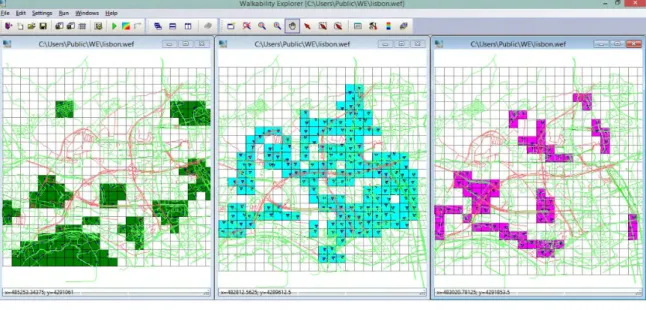
The map of relevant places describes the spatial distribution of places, services and facilities and represent the information base for the analysis of particular attributes determinant for the promotion of urban opportunities. These attributes may in principle describe the quality of places, design of space, capacity to attract different categories of peoples at different times of the day, capacity to favour different uses in the space (play, meetings, study, …), and other features important for the accessibility of the space, intended as the possibility of appropriation of the urban space in respect to human needs. For the example runs of WE, we have classified destinations of interest in three categories: commercial (shops, bars, restaurants, etc.), services (schools, health services, libraries, etc.) and recreational and leisure areas (green areas, urban parks, sport facilities open to public). In Fig. 1 we show a screen capture of the maps with these three types of destinations.
Fig. 1 A screen capture of WE representing the destination cells for different type of attractions and the destination node for each cell
2.2 EVALUATION MODELS
In the following we propose two different models for evaluating and comparing the pedestrian routes along a street network, considering their quality and walkability (Livi et al., 2004) and the quality of urban opportunities.
− The first model aims to evaluate the walkability by the analysis of pseudo-utilities. For each category of destinations, we define the pedestrian behaviour as an utility maximisation problem given the distance and the quality of pedestrian accessibility of destination places belonging to that category.
− The second aims to assign an opportunity rating to each point in space. For each category of destinations, we define the pedestrian behaviour as a pedestrian class maximization problem given the distance, the quality of pedestrian accessibility of destinations belonging to that category and the quality of destination places.
I. Blečić, A. Cecchini, T. Congiu, G. Fancello, G.A. Trunfio – Walkability explorer. An evaluation and design support tool for walkability
2.2.1 WALKABILITY AS A PSEUDO-UTILITY
We assume that a resident living at one point in space will walk to available destinations a certain amount of times, and will from that derive utility defined by the following constant elasticity of substitution (CES) function: ρ ρ 1 1
⎟
⎠
⎞
⎜
⎝
⎛
=
∑
= n i iX
U
(1)where n is the number of available destinations, Xi is the number of times the resident visits the i-th
destination and 1/(1 – ρ) is the elasticity of substitution among destinations. The constraint imposed upon the pedestrian is:
M
X
c
n i i i≤
∑
=1 (2)where ci is the cost the pedestrian foregoes to reach the destination i, and M is the available budget with a conventional constant value.
A path from an origin to a destination is a set of n interconnected edges. Besides sole distances, we describe edges on further attributes which shape the quality of the pedestrian accessibility, characteristics such as physical features, urban design, presence (or absence) of variety of urban activities. These attributes serve to model the cost of a path used in the constraint expression (2). We define the cost of a path of p edges as:
∑
∑
= =⎟
⎟
⎟
⎠
⎞
⎜
⎜
⎜
⎝
⎛
⎟
⎠
⎞
⎜
⎝
⎛
−
+
=
p k r r l r l k l kw
a
l
c
c
1 1 1 , 01
(3)where c0 is the fixed cost, lk is the length of the k-th edge in the path, ak,l ∈ [0,1〉 is the value of that edge's
l-th attribute, wl is the weight of the attribute ( ∑ wl = 1 ), and r is a parameter with 1/(1 – r) being the
elasticity of substitution among attributes. This expression yields unit variable cost of 1 when all attributes are at their lowest value (i.e. 0) , and approaches 0 when attributes approach the highest value of 1.
Among many alternative paths from an origin to a destination in a street network, we plug the cheapest one into the expression (2).
Under the constraint (2), the utility in expression (1) is maximised when:
∑
= − −=
n j j i ic
M
c
X
1 1 1 1 ρ ρ ρ (4)2.2.2 A NESTED ELECTRE TRI FOR OPPORTUNITY RATING
Here we concentrate to describe an alternative model based on the ELECTRE TRI rating procedure. In particular, for the purpose of rating urban opportunities we adapted the ELECTRE TRI approach in a particular nested procedure.
The aim of the evaluation model is to assign an “opportunity rating” to each point in space, that is to say, to put it in one among several classes of urban opportunity (one class for each among different types of urban opportunities). The core idea of the evaluation approach we propose is based on nesting several ELECTRE
I. Blečić, A. Cecchini, T. Congiu, G. Fancello, G.A. Trunfio – Walkability explorer. An evaluation and design support tool for walkability
TRI evaluation procedures, one within another. So before laying down our “nested” model, let us briefly recall the basic general ELECTRE TRI model.
Among the methods for multiple criteria evaluation of ratings (Bouyssou et al. 2006) , the so called ELECTRE TRI model (Yu 1992; Roy et al. 1993) is a prominent classification approach. This rating approach possesses several desirable properties for our purposes: (1) it allows a complete classification, and the aggregation over multiple criteria is fairly flexible, permitting to account for (2) the importance (weights) of criteria, (3) coalitions (majority rule and threshold) and (4) possible veto powers. Besides, as it will be shown, out nesting ELECTRE TRI procedure allows a careful aggregation over criteria at each level of nesting in a controllable and meaningful way more in accordance with “natural” human reasoning.
The general ELECTRE TRI procedure works as follows. Given a set of objects, evaluated on a set of criteria
h1… hn, to be assigned a rating class from a set of classes with ordinal property C1 … Cm, ELECTRE TRI first
requires that the so called limiting profiles be defined for each class. That is to say, each class Ck is defined
by a limiting profile πk on m criteria:
(
k)
n kk
π
π
π
=
1,...,
. To respect the ordinality of classes, the limitingprofiles should be defined so that < k+1
i k
i
π
π
for every i=1,…,n.To assign an object a to a rating class we then apply the following two rules (Bouyssou et al, 2006):
− if the object a has the same or higher evaluation on the m criteria than πk, it should at least belong to
the class Ck;
− if πk+1 has the same or higher evaluation on the m criteria than the object a, then it should at most
belong to class Ck. Formally:
a
P
P
a
C
a
∈
k⇔
π
k∧
π
k+1 (5)where P is the binary outranking relation meaning "belongs to the same or a higher class than".
The binary outranking relation P uses a crisp relation based on a concordance-discordance principle, that is to say, an object a outranks a limiting profile πk if there is a "significant" coalition of criteria for which "a
belongs to the same or higher class than πk" (concordance principle) and there are no "significant
opposition" against this proposition (discordance principle). In other words:
( )
k( )
k ka
D
a
C
P
a
π
⇔
,
π
∧
¬
,
π
(6) where:− C(a, πk) means there is a majority of criteria supporting the proposition that a outranks ("is at least as good as") πk;
− D(a, πk) means there is a strong opposition, that is to say a veto, to the proposition that a outranks ("is at least as good as") πk.
Following Roy (1968), for two evaluation profiles x and y, we use the following definitions of C(x, y) and
D(x, y):
( )
⇔
≥
γ
∑
∑
= ∈ n j j y x H i iw
w
y
x
C
1 ) , (,
(7)( )
x
y
h
ih
i( )
y
h
i( )
x
v
iD
,
⇔
∃
:
−
>
(8) where:I. Blečić, A. Cecchini, T. Congiu, G. Fancello, G.A. Trunfio – Walkability explorer. An evaluation and design support tool for walkability
− wi are the importance coefficients (weights) associated to each criterion;
− hi(x) is the evaluation of x on the criterion hi;
− H(x,y) is the set of criteria for which x has the same or higher evaluation than y, that is, for which hi(x)
≥ hi(y);
− γ is the majority threshold;
− vi is the veto threshold on criterion hi.
After this recall of the basic ELECTRE TRI rating procedure, let us now lay down the specific nested procedure which we have developed for evaluating urban opportunities in space.
Let we define a set of ordinal opportunity classes from lowest to highest, O1 … Om. Again, our objective is to
assign to each point in space one and only one class by taking into consideration both (1) the quality and (2) the accessibility of destinations of interest from that point.
Each destinations may fall into one or more types of urban opportunity (e.g. green areas, retail, services, etc.). To represent this fact, each destination d is evaluated in terms of “quality” per each type of opportunity, which we will denote with ql(d), where l stands for the type of opportunity.
To evaluate the accessibility, we use a detailed graph representation of the street network. A path from an origin to a destination is a set of interconnected edges. Besides their length, edges are described with further attributes which shape the quality of pedestrian accessibility, with characteristics such as physical features, urban design, presence (or absence) of variety of urban activities, and so on (see Table 1. above for a example of edge attributes). Hence, in general terms, for every edge i in a path from one point in space to one destination, we have the edge’s length l and a set of attributes a1,…ap which describe its
characteristics.
Given such a configuration of definitions and available data, the “nested ELECTRE TRI” procedure we propose proceeds in four steps:
− Step 1: Assign a walkability class to each edge in the path;
− Step 2: Aggregate the walkability of edges in the path (from Step 1) to assign an overall walkability class to the entire path;
− Step 3: Combine the walkability class of the path (from Step 2) with its length to assign an accessibility class to the couple origin-destination
− Step 4: Combine the accessibility of all the destinations (of one type of urban opportunities) reachable from an origin, to assign an urban opportunity score/class to that origin (for that type of urban opportunities)
Step 1. Edge walkability rating. In this step we use ELETRE TRI to assign a walkability rating to each
edge, using edge attributes as criteria. The step further requires that a corresponding set of criteria weights, possible veto thresholds, and the majority threshold be defined.
Step 2. Path walkability rating. Here, the ELECTRE TRI serves to assign a walkability rating to the entire path, by using the edges themselves as criteria. Their walkability classes (obtained in the Step 1) are used as criteria values, while their lengths are used as weights. So, this step only requires the definition of the majority threshold and possible vetos.
Step 3. Accessibility rating of each couple origin-destination. We now need to evaluate the overall
accessibility of the destination from the origin. The accessibility should take into account both the quality of
walk, i.e. walkability, and the distance. Therefore, for this purpose we again employ ELECTRE TRI, this time using two criteria: the walkability of the path (obtained in the Step 2) and its length. This step therefore requires to further settle the respective weights of the two criteria, as well as the majority and possible veto thresholds.
I. Blečić, A. Cecchini, T. Congiu, G. Fancello, G.A. Trunfio – Walkability explorer. An evaluation and design support tool for walkability
Step 4. Urban opportunity scores/rating. This is the final phase in which we assign the final urban
opportunity ratings to the origin point in space. It combines the information about the quality of the destinations which are reachable from that origin with their accessibility rating (obtained in the Step 3). Therefore, this step may be performed only after all the accessibility ratings have been assigned to every couple origin-destination. Also, since different destinations are, as we said, relevant for different types of urban opportunity, we proceed separately and independently, calculating an opportunity score per each type of opportunity. The opportunity score of an origin U(o) is obtained with:
( ) (
)
∑
∈ = D i i i aod d q o U( ) , (1)− where D is the set of reachable destination relevant for the type of opportunity under assessment; − q(di) is the quality score of the destination i;
− a(o,di) is the accessibility score of the destination i from the origin o; the accessibility scores are
accessibility ratings (obtained in Step 3.) transformed into numeric factors [0,1].
In the end, having calculated the urban opportunity scores for each type of opportunity, the final urban opportunity ratings are assigned by defining fuzzy thresholds on scores per each different type of urban opportunity.
3 A GENERAL OVERVIEW OF WALKABILITY EXPLORER
We are currently working on fully implementing the two evaluation models in Walkability Explorer (WE). WE is an application running on Microsoft Windows whose user interface allows an easy assessment of the walkability. It furthermore allows a comparison in terms of walkability between the current situation and hypothetical projects concerning features relevant for the walkability, in terms of the evaluation model described above.
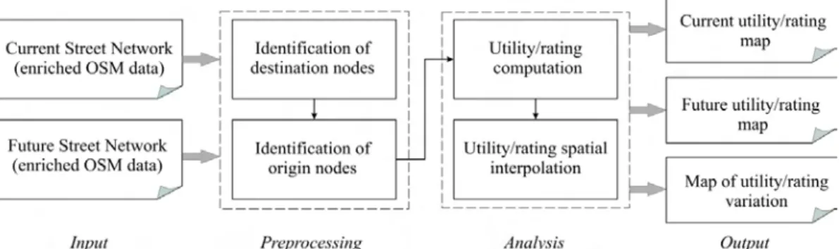
In Fig. 2 we show the standard workflow to perform a walkability evaluation in We.
First, the user is asked to provide the road networks in the format defined by the Open Street Map (OSM) project (see screen capture in Fig. 3) OSM is a collaborative project for the creation of street maps that currently makes available a huge data base covering most part of the world. In addition to the availability of street network data, the advantage of using OSM for this application lies in the ease of introducing new attributes and topological changes that affect the graphs. For this purpose there are indeed several effective editing applications freely available. If the purpose is to compare the current situation with a future project, a further road network with the features modified by the project has to be provided.
Fig. 1 The typical WE workflow. The required input data are the current and future street network in OSM with graph edges enriched with attributes relevant to the walkability (e.g. Tab. 1). After the preprocessing and analysis phases, the main output is represented by the utility-score maps (if using the pseudo-utility evaluation model) or ratings (if using nested ELECTRE TRI procedure) at the desired resolution
I. Blečić, A. Cecchini, T. Congiu, G. Fancello, G.A. Trunfio – Walkability explorer. An evaluation and design support tool for walkability
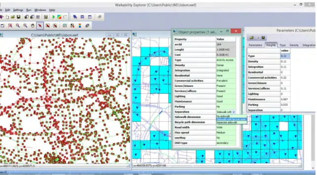
Fig. 3 A screen capture of WE representing the street network with the visualization of the edge parameters and an object property
Given the OSM data enriched with the set of edge attributes, the program identifies the areas of attractions using a regular grid of cells, according to a resolution set by the user, and constructs the sets of destination nodes (for an example see Fig. 1 above).
It is worth noting that the size of cells can be set independently for the different types of attractions. In particular, WE identifies the areas with prevalence of retail/commercial and service activities using the specific attributes attached to the edges in the OSM data. For the green/recreational attractions, the current implementation of WE exploits the polygons representing such urban areas, which are typically included in the OSM data. The program builds the set of destination nodes by finding for each attractive cell the node of the street network which is closer to its centroid (Fig. 4).
WE determines the origin nodes for both the current and future street network. It is worth noting that, to increase the comparability of results, during the filtering process the program tries to make sure that the origin nodes of current and future road networks coincide. This is not possible in areas where there are geometrical and topological changes of the network.
Fig 4 Origin nodes, attractive area and the corresponding destination node
The analysis run allows to calculate the utility-scores (if using the evaluation mod-el based on pseudo-utility functions) or ratings (if using nested ELECTRE TRI procedure). The computation is carried out for the
I. Blečić, A. Cecchini, T. Congiu, G. Fancello, G.A. Trunfio – Walkability explorer. An evaluation and design support tool for walkability
current and the future street network and for the each types of attraction. In order to shorten the run-time, WE exploits the available multi-core CPU computers implementing a parallel multi-thread approach.
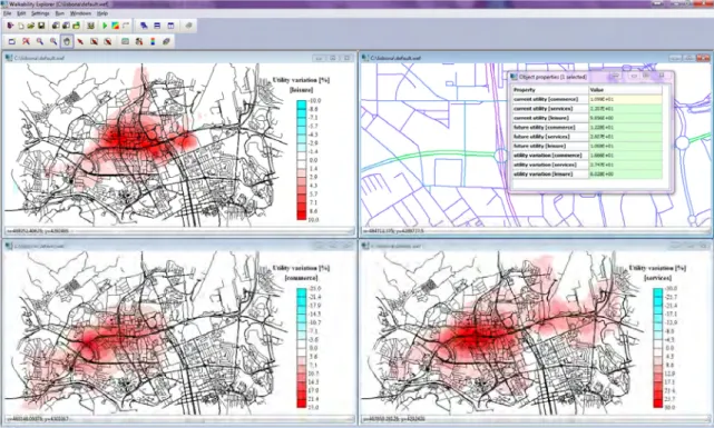
Fig. 5 A screen capture of WE representing georeferenced pseudo-utility maps for different types of attractions
The final output of the program are the georeferenced utility-score maps (e.g. Fig. 5) or ratings for both the current and future street networks and for all the types of attractions. Moreover, WE provides the map of utility/rating variation due to the project. All the above maps can be exported in a suitable GIS format for further elaborations.
The processing described above require to extensively operate with geo-referenced data, as well as the possibility to efficiently perform spatial queries. For this reason, the program has been implemented using the C++ MAGI library (Blecic et al. 2009; Blecic et al. 2009), which makes available the necessary functions of spatial indexing.
Besides producing georeferenced maps, WE allows the results to be exported in the open csv format for further analysis in other GIS and statistical analysis tools. One such possible analysis is to calculate indicators for comparing the aggregate variation of walkability between alternative scenarios as well as its spatial distribution and dispersion in relation to the populations inhabiting the urban area under consideration.
4 CONCLUSIONS
Capability approach coupled with the analysis of accessibility provides a compelling theoretical framework for assessing relevant aspects of the quality of life in cities. The space and urban environment are important constituent of certain human capabilities and are determinant for the individual life in cities. Among other dimensions of individual wellbeing (health, education, political participation, and so on), the way our cities and physical environment ‘functions’ – the way they are shaped, organized, and used by social practices – matters.
I. Blečić, A. Cecchini, T. Congiu, G. Fancello, G.A. Trunfio – Walkability explorer. An evaluation and design support tool for walkability
Architects, urban planners and policies makers could use urban capabilities to read and interpret the multiple relations between the individual and the city, to unveil the circumstances in which the city is an ‘obstacle’ to the needs and aspirations of its inhabitants, to better define and govern urban design processes which aim at removing these obstacles, to promote the right to the city (Lefebvre 1978; Harvey 2009; Soja 2010) for all.
Such design attitude requires tools. Walkability Explorer is an attempt to implement evaluation models and to provide an user-friendly tool for assessing walkability which may prove useful for improving effectiveness, relevance, and inclusiveness of urban design and transport planning.
There is further work to be done and there are many areas in which we plan to extend WE’s features. Foremost, to become a more complete decision support for assessing urban capabilities, besides walkability it should also be able to take into account the car and public transportation accessibility, and the way they interact with the pedestrian accessibility. Such incorporation of non-pedestrian mobility into WE would be an indispensable step to also take into account the quality of accessibility of not only neighbourhood-level destinations, but also those on the urban and metropolitan/regional level, which of course also play a relevant role in shaping overall urban capabilities of people.
We intend to pursue these objectives in our future work.
REFERENCES
Blecic, I., Borruso, A., Cecchini, A., D’Argenio, A., Montagnino, F., Trunfio G.A. (2009), “A cellular automata-ready GIS infrastructure for geosimulation and territorial analysis”, Computational Science and Its Applications- ICCSA 2009, Vol. 5592 of LNCS, 313-327.
Blecic, I., Cecchini, A., Congiu, T., Pazzola, M., Trunfio, G.A. (2013), “A Design and Planning Support System for Walkability and Pedestrian Accessibility”, Lecture Notes in Computer Science, 7974, 284-293.
Blecic, I., Cecchini, A., Trunfio, G.A. (2009), “A general-purpose geosimulation infrastructure for spatial decision support”,
Transactions on Computational Science, 6, 200-218.
Bouyssou, D., Marchant, T., Pirlot, M., Tsoukias, A., Vincke, P. (2006), Evaluation and decision models with multiple criteria, Stepping stones for the analyst, Vol. 86, Springer.
Harvey, D. (2009), Social justice and the city, The University of Georgia Press, Athens, Georgia. Lefebvre, H. (1968), Le droit à la ville, Anthropos, Paris.
Livi, A., Clifton, K.J. (2004), “Issues and methods in capturing pedestrian behaviours, attitudes and perceptions: Experiences with a community based walkability survey”, Transportation Research Board, Annual Meeting. Roy, B., Bouyssou, D. (1993), Aide multicritère à la décision: méthodes et cas, Economica, Paris.
Sen, A. (1993), “Capability and Well-Being”, in Nussbaum, M. and Sen, A. (eds.), The Quality of Life, Oxford Clarendon Press, New York, 30-53.
Soja, E.W. (2010), Seeking spatial justice, University of Minnesota Press, Minneapolis.
Yu, W. (1992), “ELECTRE TRI: Aspects méthodologiques et manuel d'utilisation”, Document du LAMSADE, 74, Université Paris-Dauphine (1992).
IMAGES SOURCES
I. Blečić, A. Cecchini, T. Congiu, G. Fancello, G.A. Trunfio – Walkability explorer. An evaluation and design support tool for walkability
AUTHORS’ PROFILE
Ivan Blečić
Researcher in the field of Economic Appraisal and Evaluation at the Department of Architecture Design and Urban Planning of Alghero, University of Sassari.
Arnaldo Cecchini
Dean of the Department of Architecture Design and Urban Planning of Alghero, University of Sassari, and full Professor in Urban Planning.
Tanja Congiu
Temporary researcher in the field of Transportation at the Department of Architecture Design and Urban Planning of Alghero, University of Sassari.
Giovanna Fancello
Post-doctoral fellow in the field of Urban Planning at the Department of Architecture Design and Urban Planning of Alghero, University of Sassari.
Giuseppe A. Trunfio
Researcher in Computer Engineering at the Department of Architecture Design and Urban Planning of Alghero, University of Sassari.