Conference Proceedings
2017
Editor
Evangelos Livieratos
Published by the Laboratory of Cartography & Geographical Analysis, Aristotle University of Thessaloniki
Venice
Aristotle University of Thessaloniki [1] Laboratory of Cartography & Geographical Analysis
International Cartographic Association
Commission on Cartographic Heritage into the Digital
Digital Approaches to Cartographic Heritage
Editor: Evangelos Livieratos Proceedings
12th ICA Conference Digital Approaches to Cartographic Heritage Venice 26-28 April 2017
Thessaloniki: AUTH CartoGeoLab – ISSN 2459-3893
All transactions relevant to Proceedings orders are entirely under the legal authority of the
Aristotle University of Thessaloniki (AUTH) Research Committee University Campus
541 24 Thessaloniki, Greece
The Proceedings distributed to all registered participants of the Venice2017 Conference
To order extra digital copies of the Proceedings Contact the AUTH CartoGeoLab:
The 12th Conference of the series Digital Approaches to Cartographic Heritage organised annually, since 2006, by the ICA Commission on Cartographic Heritage into the Digital, hosted in the Aula Magna of the University Iuav of Venice, Tolentini, Santa Croce, Venice, 26-28 April 2017
ICA Commission on Cartographic Heritage into the Digital: http://cartography.web.auth.gr/ICA-Heritage
12th ICA Conference “Digital Approaches to Cartographic Heritage: http://cartography.web.auth.gr/ICA-Heritage/Venice2017 AUTH Laboratory of Cartography and Geographical Analysis: http://cartography.web.auth.gr/cartogeolab
Aristotle University of Thessaloniki [2] Laboratory of Cartography & Geographical Analysis
The Conference Boards
Scientific Board, ICA
Georg Gartner Vienna László Zentai Budapest Pilar Sánchez-Ortiz Madrid Evangelos Livieratos Thessaloniki Carme Montaner Barcelona Mátyás Gede Budapest Francesco Guerra Venice Chris Fleet Edinburgh Ferjan Ormeling Utrecht Gabriele Bitelli Bologna Marcy Bidney Milwaukee Stuart Dunn London Piero Falchetta Venice Liqiu Meng Munich
IUAV Local Organisers
Caterina Balletti Venice Francesca Rizzi Venice Caterina Gottardi Venice
Commission Support
Chrysoula Boutoura Thessaloniki Alexandra Kousoulakou Thessaloniki Maria Pazarli Thessaloniki
Nopi Ploutoglou Thessaloniki Elpida Daniil Thessaloniki Angeliki Tsorlini Zurich
Conference Support
ICA – International Cartographic Association
IUAV – University Iuav of Venice / Laboratories System Circe AUTH – Aristotle University of Thessaloniki / CartoGeoLab XEEE/HCS – Hellenic Cartographic Society
e-Perimetron – The International Web Journal on Sciences and Technologies Affined to History of Cartography and Maps
MAGIC – Maps & Geoinformation Curators Group
Commission Supporting Institutions
ICGC – Cartographic and Geologic Institute of Catalonia, Map Library, Barcelona
IUAV – University Iuav of Venice, Cartography & GIS Lab and Photogrammetry Lab, Venice NLS – National Library of Scotland, Map Section, Edinburgh
ELTE – Eötvös Loránd University, Department of Cartography & Geoinformation, Budapest IONIAN – Ionian University, History Department, Corfu
Aristotle University of Thessaloniki [3] Laboratory of Cartography & Geographical Analysis
The Proceedings
This volume contains the papers presented in the 12th ICA Conference on Digital Approaches to Cartographic Heritage, organized by the International Cartographic Association Commission on Cartographic Heritage into the Digital,1 in partnership with the University Iuav of Venice, Laboratory of Cartography & GIS and Laboratory of Photogrammetry in association with MAGIC – the Maps & Geoinformation Curators Group in cooperation and with the support of the Aristotle University of
Thessaloniki, AUTH CartoGeoLab – Laboratory of Cartography & Geographical Analysis and the Hellenic Cartographic Society.
Following the previous eleven annual Conferences on the Digital Approaches to Cartographic Heritage held in Thessaloniki (2006), Athens (2007), Barcelona (2008), Venice (2009), Vienna (2010), The Hague (2011), Barcelona (2012), Rome (2013), Budapest (2014), Corfu (2015), Riga (2016), this 12th Conference continue enriching the literature dedicated to the issue of Cartographic Heritage with special interest in the digital embodiment.
This year’s Conference with participation from 21 countries representing 69 institutions (universities, national and university libraries, archives and museums, research institutes, the public and private geospatial sectors, organisations) is organised in eight working sessions dealing with issues related to the ICA
Commission and the MAGIC Group terms of reference, namely: digitisation – georeference; cartodiversity content analysis in terms of geometry and thematics; landscape change studies based on map-archival sources; visualisation of cartoheritage, including thematic portals; interconnection of cartographic archival sources, especially map and textual data; historical terrestrial and aerial photography, including photo-related post-cards and relevant material subjects of cartographic parametrisation; cartoheritage web providing issues; interaction of cartoheritage with map and geoinformation curatorship of cartodiversity; development of cartoheritage as a cultural issue, within the context of GLAM, addressed to education and to the general public; geographic affinities with cartoheritage; cartoheritage and Digital Humanities; policy making and strategies for geoinformation / map collection development; metadata models and data-exchange standards for library, archive and museum items; new services and new technologies in geoinformation / map collection; preservation, access and innovation in visualisation and presentation (virtual exhibitions) of cartographic heritage (analogue and digital); integration of other (geo)sources and materials; cooperation with libraries, archives, museums, and partnership with the public and private sectors.
Fifty-three papers are included in this Conference Proceedings; from those, thirty-seven are published in full-text form and sixteen represented with summaries, covering a total of 349 pages. The major characteristic of this collection of papers is, for one more time, the strong interdisciplinarity of the issues treated showing the multifaceted content of Cartographic Heritage, especially when embodied into the Digital mainstream. The contributions related to cartography associated GLAM are also numerous proving the relation of
cartoheritage with the general domain of Cultural heritage.
The Commission Chair and the Vice-Chairs Carme Montaner and Mátyás Gede acknowledge the
cooperation of their hosts, the local organisers and staff of the University Iuav of Venice, Caterina Balletti, Caterina Gottardi and Francesca Rizzi, the Commission supporting group from the Aristotle University of Thessaloniki, Chrysoula Boutoura, Alexandra Koussoulakou, Maria Pazarli, Nopi Ploutoglou, Elpida Daniil and Angeliki Tsorlini from ETH Zurich, the colleagues from the ICA Executive Committee Meno-Jan Kraak ICA President, László Zentai ICA Secretary General, Pilar Sánchez-Ortiz Rodríguez ICA EC liaison to the Commission and Georg Gardner the ICA Past President, for their support and active participation as well as the members of the Scientific Board and all participants who contributed and attended the
Conference.
Evangelos Livieratos Commission Chair and Editor
1 In cooperation with the Commission Supporting Institutions: ICGC – Cartographic and Geological Institute of
Catalonia, Barcelona; IUAV – University Iuav of Venice; NLS – National Library of Scotland, Edinburgh; ELTE – Eötvös Loránd University, Budapest; IONIAN – Ionian University, Corfu; AUTH – Aristotle University of Thessaloniki.
Aristotle University of Thessaloniki [4] Laboratory of Cartography & Geographical Analysis
Contents
CHAPTER 1 7
Simon R. Recogito 2: new developments in linked data annotation of maps and texts 8
Blackler A. Negroponte in the 14th century: a reconstruction integrating contemporary cartographic
and documentary evidence with the archaeological record 9
Kozica K. The map of the Polish-Lithuanian Commonwealth by Andrzej Pograbka published in
Venice in 1570 from the Niewodniczański Collection Imago Poloniae at the Royal Castle in
Warsaw–Museum 10
Sen A. Comparison of past and present maps of Istanbul historic peninsula in Gis, based on the
insurance maps of Jacques Pervititch 15
Tsorlini A., R. Sieber R., L. Hurni Combining current vector data with historical maps and textual
data to study the development of the city of Zurich, Switzerland 29
Santamaria Varas M., P. Martinez Diez The historic charter of Barcelona 40 Metcalf A., S-M. Smith The 1870 cadastral map of Rio de Janeiro 51 Livieratos E., C. Boutoura The Ing. Raseau manuscript large-scale maps of Cyclades, a case of
French military thematic cartography of late 17th century with remarkable aesthetic value 52
CHAPTER 2 63
Balletti C., M. Calzavara, F. Contò, M. Mazzanti, , S. Meggiato, F. Rizzi The Iuav maplibrary:
digitising, cataloguing, dissemination and teaching 64
Vardakosta I., S. Kapidakis Geospatial collections in IRs: a survey in map/Gis libraries 75
Vāvers R. The map collection of the National Library of Latvia: into the digital 82
Walt R. MapSeries – Web based application to support cataloguing of map series 85
Klimek T. Interconnection of medieval texts and historical maps on the example of Manuscriptorium
Digital Library 86
Fowler I., K. Gwinn Becker Beyond the framework: transforming twentieth-century library websites
into twenty-first century digital collections 93
Nanetti A., A. Cattaneo, S.-A. Cheong, Y.-Y. Chiang, C.-Y. Lin Visual knowledge aggregation:
from static to dynamic information systems in library contexts 104
CHAPTER 3 105
Zentai L. A crypto-cartophilatelist’s thoughts on cartographic heritage 106
Egmond M. van A new online historical atlas: the Dutch Bosatlas digitized and annotated
(1877-1939) 107
Blunt N. The Cognita Project: a new digital approach to teaching with cartography at a secondary
school 117
Galambos C., L. Makádi, E. Bodor, B. Péterdi, Z. Lantos, K. Palotás From the depths of a drawer to
Google Earth: digital exhibition of Hungarian fossils, minerals and decorative stones 118
Aristotle University of Thessaloniki [5] Laboratory of Cartography & Geographical Analysis
Buonora P. The cartographic collection of the State Archive of Rome online: archival issues and
digital models 130
Jackson C. Against ‘animal farm holism’ and 20th-century Constructivism: why cartographic
heritage must start with preserving pixels 131
CHAPTER 4 132
Guarducci A., G. Tarchi The first geodetic map of the Grand Duchy of Tuscany (scale 1:100,000,
approximately 1840): georeferencing and applicated studies 133
Timár G., C. Galambos, S. Kvarteig, E. Biszak, S. Baranya, N. Rüther Coordinate systems and
georeference of Norwegian historical topographic maps 146
Abshire C., D. Gusev, S. Stafeyev The Fertile Crescent in Ptolemy’s “Geography”: a new digital
reconstruction for modern Gis tools 152
Talich M. Digitizing of old maps and on-line tools for using them 168
Cajthaml J., T. Janata Correlation testing of Müller’s map of Bohemia and the First Military Survey
maps in the area of today’s Czechia 169
Timár G., B.P. Kocsis, G. Molnár, M. Deligios, V. Baiocchi, C. Galambos, E. Biszak Habsburg
topographic cartography of the Italian peninsula in the first half of the 19th century 177
Balletti C., R. Gibin, C. Gottardi, E. Livieratos Preliminary numerical investigations on “Liber de
Existencia Riveriarum et Forma Maris Nostri Mediterranei” 184
CHAPTER 5 195
Novotná E. The Czech portals for visualisation of cartographic culture heritage 196
Biszak E., S. Biszak S, G. Timár, D. Nagy, G. Molnár Historical topographic and cadastral maps of
Europe in spotlight – Evolution of the MAPIRE map portal 204
Gužauskytė E. Spatio-temporal dimensions of Christopher Columbus’s naming discourse through
visualization 209
Kepka Vichrova M., R. Fiala, P. Hájek, M. Kepka, O. Dudáček, O. Čerba, V. Čada,
W. Dorner, P. Vondráček Peregrinus Silva Bohemica - cartographic and historical heritage along
the ways of Silva Bohemica
210
Pridal P., J. Vykydalova Web toolkit for old maps: georeferencing, research and feature extraction 219
CHAPTER 6 220
Gallia A. Mapping Italian small islands. Cartoheritage and digital issues 221
Ranzi R., K. Werth, F. Gentilin, S. Mangiapane The Adige River map in 1:20,736 scale of
Leopoldo de Claricini-Dornpacher (1847) 222
Koussoulakou A., Y. Mitzias, I. Andreanidou Mapping the City Walls of Thessaloniki through time 233
Havlicek J. Map application about castles and chateaux in the Czech Republic 234 Bitelli G. R. Camassi, G. Gatta Gis and historical seismology: the case of the earthquake occurred in
Italy in 1661 240
Panecki T. Settlements and administrative units on old maps: a case study of semantic integration 244 Balletti C., L. Galeazzo, C. Gottardi, M. Massaro From historical maps to digital technologies for
Aristotle University of Thessaloniki [6] Laboratory of Cartography & Geographical Analysis
CHAPTER 7 257
Anoyatis-Pelé D., C. Tsiamis, I. Athanasopoulou, C. Boutoura Topographic changes and public
health: the case of the national anti-malaria campaign in Messolonghi lagoon, Greece (1950-1960) 258
Piccardi M., E. Pranzini, L. Rombai Historical cartography and coastal dynamics of the Apuan
littoral in the modern and contemporary periods: the port of Marina di Carrara (Tuscany, Italy) 265
Bertacchini M. CartoHeritage and the “Culture of the Landscape” in the Modena area (Northern
Italy) 279
Zolezzi G., E. Dai Prà, D. Allegri, S. Zen, D-C. Eftaxia, V. Scorpio Reconstructing river
morphological dynamics. Historical Cartography for river management and restoration in Trentino 284
Siniscalchi S. The value of the landscape in the individual and collective perception through the
transformation of postal cartography 294
Sperti L., S. Cipriano, A. Paveggio, S. Ganzaroli, E. Delpozzo Altinum: discovering a hidden
municipium through GIS, historical research and new excavations 310
CHAPTER 8 324
Hernández Cabrera J-O. Nesonyms deturpation and computational palaeography: first approach 325 Anoyatis-Pelé, D., C. Tsiamis, I. Athanasopoulou, C. Boutoura
Toponyms and cartographic confusion of Lepanto naval battle (1571) 326
Balletti, C. Gottardi, F. Guerra, E. Livieratos Oval projections: the Italian sixteenth century
cartographic innovation 332
Molnár G., G. Timár, E. Biszak The advantage of publishing intermediate products of historical air
photos 339
Gede M., Z. Ungvári, G. Nagy Assessing the accuracy of photogrammetric reconstruction by
comparison to laser scanned data 343
Kraak M.-J. Minard’s flow maps redrawn 348
Aristotle University of Thessaloniki [222] Laboratory of Cartography & Geographical Analysis Roberto Ranzi1, Kurt Werth2, Fulvio Gentilin3, Salvatore Mangiapane4
The Adige River map in 1:20,736 scale by Leopoldo de Claricini-Dornpacher
(1847)
Keywords: Adige River, Adige valley, Etschtal, Leopoldo de Claricini-Dornpacher, river training, fluvial landscape
Summary
In the 50th year anniversary of the November 1966 Adige river flood, which hit at the same time Florence and Venice 14 map sheets of the Adige river valley between Meran and Borghetto, in northern Italy, were scanned in high-quality and printed for the public ac-cess and use. The lithograph was printed in 1847 in a 1:20.736 scale (1”:288° i.e. 1 Zoll=288 Klafter) in Innsbruck by Leopoldo de Claricini-Dornpacher (1812-1888) and depicts the river and its valley as it was in almost natural conditions when the river training works just started in the intermediate reach. A georeferencing of one sample sheet shows that a RMSE between 10 and 15 meters can be reached. A comparison with the actual geomorphology of the river especially in its southern reach is possible thanks to the map. One of the objectives of this study is, also, to make a beautiful map accessible to a wide public, to let people enjoying the river landscape as it was and will never return, until the next glacial era.
Introduction
In view of the development of Cartographic heritage as a cultural issue and with the objective to make accessible to the general public ancient river maps, an editorial initiative was taken which consisted in a high-quality 450 dpi scan and publication of 14 mid XIX century map sheets depicting the Adige river and its valley between Meran and Borghetto, in northern Italy. The Author of the map sheets was the engineer and architect Leopoldo de Claricini-Dornpacher (1812-1888) and his lithograph we present was printed very likely in the year 1847 in Innsbruck.
In this paper a brief history about the Adige river maps in the XIX century is first summarised, by comparing the river cartography with some contemporary or previous examples for central Europe. Then, a short biography of Leopoldo de Claricini introduces the description of the map and of some copies archived in libraries in Italy, Innsbruck and Paris, pointing out their differences with the newly re-edited 14 map sheets. Finally a preliminary assessment of the positional accuracy of these 1:20.736 scale map sheets shows that the 10 to 15 m RMSE error in position we found in our geo-transformations tests is not too far from the RMSE of about 6 m obtained when geo-transforming the much larger 1: 3.456 scale map of the same Author (Dai Prà & Mastronunzio, 2014), focused on the Adige River course.
This indicated that the map has also a technical value and allows a reliable comparison of the ancient and actual landscape conditions, together with geomorphological changes of the Adige River across centuries. Finally we point out the ‘aesthetic’ and ‘cultural’ value of the map which enables the public to virtually explore the environment of the Adige river valley before its major artificial ‘manipulations’ occurred in the XIX century and the dramatic urbanization of the XX century, still continuing now, with new threats to the last remnants of the river and agricultural landscape.
1 Professor of Hydraulic Structures, Department of Civil, Environmental, Architectural Engineering and Mathematics
(DICATAM), University of Brescia
2 Agriculture consultant, Kurtwerth Consulting, Egna/Neumarkt 3 GIS expert, DICATAM, University of Brescia
Aristotle University of Thessaloniki [223] Laboratory of Cartography & Geographical Analysis
Adige River maps in the XIX century in the framework of river cartography in central Europe
In the recent years cartographers and geographers paid wide attention to giving new life to old river maps in Central Europe. The inspiration of the re-edition of the Claricini map came also by reading the geo-historical novel Danube by Claudio Magris (1986) which mentions the archives in Hungary holding the 1:3 600 scale “Danube maps” corresponding to 1”:50°, i.e. 1 inch (Zoll=2,634 cm) per 50 fathom (Klafter=1,896484 m), produced after the surveys of Mátyás Huszár (conducted from 1823 to 1829), Pál Vásárhelyi (1829-1835) and Ottó Ferenc Hieronymi (1835-1839). Today at least 1756 sheets are
conserved with dimension of 28 × 22 Wiener Zoll in the Hungarian State Archives (Mészáros & Timár, 2010) and they represent the Danube river from Dévény, in Slovakia, to Pétervárad, in Serbia. Their printout was completed in the year 1845 and they were almost contemporary to the Leopoldo de Claricini maps we are going to describe. The Danube mapping was updated in 1908 as the 1823-1845 maps became outdated (Mészáros, 2011).
River maps with sufficient degree of accuracy for technical applications, such as river training works, date back in central Europe at least to the second half of the XVII century, when, for instance, the maps and plans of the Leopold’s fort (current Leopoldov in Slovakia, which was then part of the Upper Hungary) depict also in detail the Váh River, which was at the border between the Ottoman realm and the Habsburg monarchy (Pišút, 2016). Processing of later maps enabled the reconstruction of the development of the Váh River over a 350-year period, which is 44 years longer than the reconstructed sequence of the Danube River in Bratislava (Pišút, 2012).
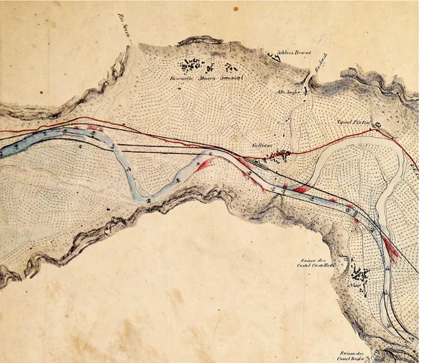
For the southern part of the former county of Tyrol both military and hydraulic engineering reasons motivated the edition of the “Nowak-Plan” hydro-topographical maps at scale 1:3.456 (1”:50°), in the years 1803-1805 (Werth, 2003), during the clash of the Habsburg monarchy with the Napoleon army. The Nowack maps, well described also in their metric content by Mastronunzio & Dai Prà (2016), depict with marvellous pictorial detail in 131 painted sheets the Adige river valley, together with an over simplistic rectification plan of the river, from Meran to Besenello, between Trento and Rovereto. The “Second Military Survey (1806-1869)” maps coordinated by the Habsburg monarchy and, later, the Austro-Hungarian administration (Timár et al., 2006) covered the entire Adige valley with 1:28.800 maps sketched after surveys conducted in the 1816-1823 period (Werth, 2003; Ranzi & Werth, 2016). An example of these survey maps, which are also called Franziszeische Landesaufnahme is given in Fig. 1, where the junction of the Noce River (Nos Bach) with the Adige River (Etsch Fl.[uss]) at
S.Michele all’Adige is represented. It can be shown that in this early XIX map some hypotheses of river rectification and diversion are sketched, although both rivers are still in natural conditions, thus
indicating that the discussion about the possible solutions for river training works, which just started in the upstream reach of the river, was already very vivid in that period, after some first proposals based on the suggestions written in Latin by Zallinger zum Thurm (1778).
Aristotle University of Thessaloniki [224] Laboratory of Cartography & Geographical Analysis
Figure 1. A detail, close to the Noce-Adige rivers junction, north to Trento, of the map of the “Second Military Survey”, also named
Franziszeische Landesaufnahme, sketched
between 1816 and 1823 for the Adige river area in 1:28.800 scale. The orientation is in the South to North direction
(Österreichisches Staatsarchiv, also available from the mapire.eu web site after being geo-referenced according to Timar et al., 2006 and Biszack et al., 2014).
After the Franziszeische Landesaufnahme maps, the most complete map of the Adige river valley was, indeed, the Claricini map we will present in the next section. Before that we have to mention the cartographic effort conducted by the “Brioschi Commission” established in 1873 after the two large floods of May and September 1872 of the Po River and which coordinated until 1880 the edition of the 89 river cross sections in scale 1:400 in height and 1:4000 in width between Pavia and the Adriatic sea (Sibra, 2004) and of the maps in scale between 1:28.800 and 1:50.000 for the river reach from Turin downstream to the sea (Ferrari and Pellegrini, 2007). These “Po river maps” were fundamental for the design of the river training works (Bacchi and Orlandini, 2007) on a rational basis, which for the Po river, conducted at that time to the so-called “Po-system” solution, which leaves “room for the river” as recommended in the more modern river training concepts.
Leopoldo de Claricini-Dornpacher (1812-1882) and his Adige river map-sheets
The motivations which conducted to the edition of a detailed topographic map of the Adige river valley were in part related to the need to update and improve the river training projects started in the Bolzano-Salorno River reach in the period 1815-1826 following some of the indications of the “Nowack Plan”. In 1845 Florian Pasetti published a new river regulation project, which was based on new topographic surveys, conducted in the same period (Weber von Ebenhof, 1892a). But the second most important reason, together with the military one, was the need of a detailed topography for the design of the Verona-Bolzano railway. The concept of this railway was developed in the 1840-1850 period and it is
Aristotle University of Thessaloniki [225] Laboratory of Cartography & Geographical Analysis not a case that the original of the small scale Claricini map which was recently scanned and published by Ranzi & Werth (2016) comes from an antiquarian bookseller in Trento who collected the archive of a preliminary design of the Verona-Bolzano railway, sketched in France. The author of the final design of the Verona-Bolzano railway was Luigi Negrelli (Fiera di Primiero 1799 - Vienna 1858) and the
infrastructure was completed between 1853 and 1859. As the railway intersected the original
watercourse in several points it was important to have a detailed topography of the valley and the river. The contribution of Leopoldo de Claricini-Dornpacher (12.8.1812–1882) was fundamental. He was in that period “Kreisingenieur” or “Ingegnere circolare” in Trento, meaning that he was responsible of civil works (construction, transportation and hydraulic engineering) in that district. He was born in Versa di Gradisca from a noble family originating from Bologna and later established in Gorizia/Görz; he graduated in engineering and architecture at the Technical University of Vienna and he worked in Innsbruck, Trento, Gorizia and Trieste. He is famous mainly for having designed at least 20 churches in Trentino, South Tyrol and Tyrol (Tabarelli, 1997; see also Oberziner). In his duty of “Kreisingenieur” he coordinated the edition of a topographic map, which was printed, as far as we know, in two scales. The 1:3.456 large scale version, signed by “Leop: v: Claricini lith:”, was printed based on the
lithography studio signed as “Lith: Ans: des Jos: Schöpf in Innsbruck” and depicts the river from Meran to Calliano, and a narrow land strip along it, in 54 sheets, to the knowledge of the authors. A version of this map, entitled “Situation des Etschflusses Blatt n° 14 to 54” is conserved in the Historical Archive of Trento Municipality (ACT 3.8-VII.2.1870) and is part of the technical drawings of the 1870 river regulation project by Martin Kink. In the sheets 53 and 54 the signature of Claricini is not present, although the style is the same of the previous sheets. Four further maps drawn in the Claricini-style but without signature and numbered 55 to 58 are available for the Calliano-Borgo Sacco river reach. Dai Prà & Mastronunzio (2014) performed geometric corrections and then rectified two sheets of the large-scale Claricini map and the resulting Root Mean Square Error was between 5 and 6 metres, depending on the order of the polynomial transformation (Guerra, 2000).
The small scale 1:20.736 “Claricini Tridentina” map
A second lithograph was made by the Lithographie Anstalt v. C.A. Czichna in Innsbruck made a second lithograph, and the author’s signature, reported on every sheet, is “L. v. Claricini lith.” It does not have a specific title and the versions archived in libraries in Italy, Austria and France report different
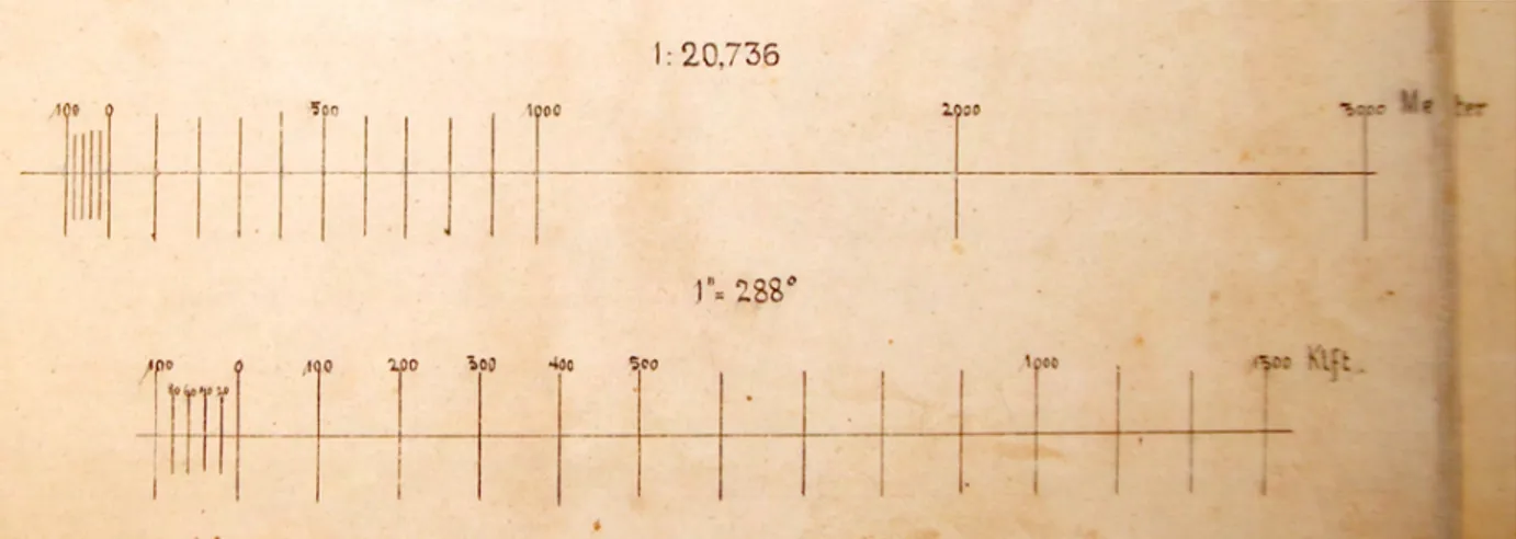
denominations. It is composed of 14 sheets with dimension 508 ± 2 mm x 368 ± 2 mm, numbered from I to XIV, and one additional sheet, labelled as “ad I” with dimension 367 x 163 mm. The orientation reports the South to North arrow approximately from the right to the left of the map sheets. A ruler ranges from 0 to 1000 Klafter and the scale printed on the original map is 1° = 288”, meaning that 1 Zoll corresponds to 288 Klafter. Because one Wiener Klafter corresponds to 72 Zoll the final nominal scale is 1:20.736. The map version in the private library of the first author, we will call “Claricini-Tridentina”, has three colours: in addition to the black which is the basic colour of the map sheets, the red colour is used to highlight the main road named “Post Strasse” and the sketch of three hypotheses of the diversion of the Noce River (Fig. 2) at the junction with the Adige river and of two river meander straightening of “Centa”, in Trento and at Lidorno. A light blue is used to colour the river. The rest of the map is untouched and in very good conditions of conservation. The 14+1 sheets were scanned with a high quality scanner with 450 dpi resolution and then resized by a scaling factor of about 5% to obtain, after joining the sheets “I” and “ad I”, 14 sheets with a nominal scale 1:21.957 and a standard sheets size of 350 x 500 mm. The 14 sheets were printed in high quality and collected in a semi-rigid envelope together with a monograph describing the map in the framework of a brief history of the cartography of the region and of the river training works (Ranzi & Werth, 2016). The purpose is to make accessible to the public this document, which is part of the history of the region.
The fact that the small-scale Claricini map sheets have undoubtedly a 1:20.736 nominal scale is con-firmed by the scale added to a version of the map sheets VII to XIV archived at Consorzio Trentino di Bonifica. On sheet nr. VIII of this map we will call “Claricini-CTB”, the original 1” = 288° scale is reported together with the 1:20.736 scale and two rulers, in Klafter and in metres (Fig. 3). The map
Aristotle University of Thessaloniki [226] Laboratory of Cartography & Geographical Analysis sheets collection is entitled “Rotte ed erosioni lungo l’Adige nella III sez. in causa delle piene del 1868 e del 1882”, indicating that the main use of the map was related to the documentation of the flooding and the levee breaches position occurred in 1868 and 1882.
A complete version of the map-sheets stored in the Bibliothèque nationale in Paris, we will call “Claricini Parisienne”, is archived as:“Carte du cours de l’Adige depuis Meran jusqu’à la frontière lombardo-vénitienne” [ca 1847], L. v. Claricini, lith. Imprimé Innsbruck: Lith. Anst. Von C.A. Czichna. 1:28.800, 15 flles en noir, bleu et rouge; 520 x 375mm. Paris, Biblioteque Nationale, GE DD-5842. The reported scale 1:28.800 is not correct. This mistake, which induced in some misinterpretations some authors, is probably caused by the fact that several military French and Austrian map sheets from the early XIX century, including the Franziszeische Landesaufnahme, were edited with the 1:28.800 scale, obtained by rescaling by a factor of three the 1:86400 Carte Topographique de la France (1744-1793) by Cassini (Mastronunzio & Dai Prà, 2016). The “Claricini-Parisienne” map is important because it indicates an approximate “ca.” but specific “1847” date for the map. This date, for the reasons
described in Ranzi & Werth (2016), related to the date of the contemporary river training works, is very realistic and can be assumed as correct.
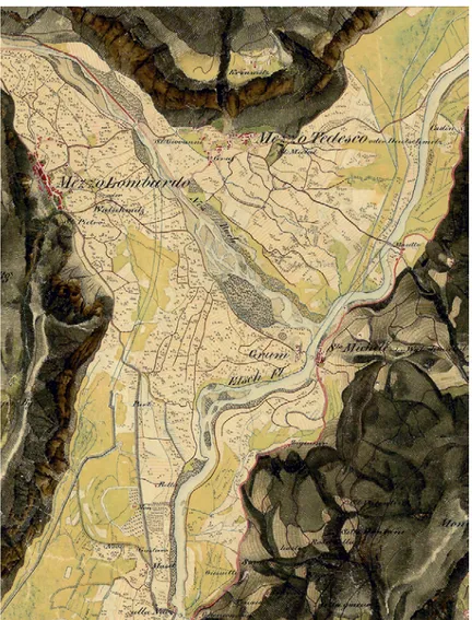
Figure 2. A detail of the Claricini “Tridentina” map sheet nr. VIII at the junction of the Noce with the Adige River. Three hypotheses of the Noce river diversion, completed in the year 1853, are sketched. It is worth noticing the Italian and German names of the towns of Mezzotedesco/Deutschmetz and Mezzolombardo/Wälschmetz, the only bilingual toponyms on the 14 map sheets. (©courtesy of TEMI Editrice, Trento)
Aristotle University of Thessaloniki [227] Laboratory of Cartography & Geographical Analysis
Figure 3. The original 1”=288° (1 Zoll=288 Klafter) scale (bottom) of the small-scale “Claricini-CTB” map-sheets corresponding to the 1:20.736 metric scale (top) added to the version conserved at Consorzio Trentino di Bonifica
In addition to the Paris version another original of the 14+1 small-scale map sheets is conserved at Landesbibliothek Dr. Friedrich Tessman in Bolzano (number III/A 6947) and it is peculiar because the inundation areas and the position of some levee breaches of the 1845 and 1868 floods are re-ported. The fact that the “Claricini-Tessman” map, which is entitled “Etschkarte von Meran bis Borghetto” is the result of an extensive use of the sheets is confirmed by the fact that the trace of the Verona-Bolzano railway, completed in 1859, is also reported, together with several river training works completed in the 1850s and 1860s but not those completed in the 1880s, as the Besenello-Calliano (1880), Chiusole (1880) and Ischia-Wolkenstein (1887-1889) straightening (“drizzagni” in Italian and “Durchstich” in German). This map is important because it is the only one among those the authors had access to, which reports a legenda, sketched on the sheet nr. XIV with six types of land use: wine yards, arable crops, grasslands, wetlands, shrubs, gravel and sand bars.
A fourth complete version of the small scale Claricini map sheets is kept at the Tiroler Landesmuseum Ferdinandeum in Innsbruck, where it is named Karte der Etschregulierung in 14 Blaettern von Meran bis Borghetto südliche Rovereto, ca. 1840-1850 (TLMF Innsbruck, Historische Sammlungen,
Kartographie, number K II/75). This “Claricini-Ferdinandeum” map is peculiar because it re-ports the extent of the 1845 flooded areas and the wetlands remaining after that high flood. Only two early hypotheses for the diversion of the Noce river junction with the Adige river, and not the final one, are reported, thus indicating that these map sheets are one of the earliest version, together with the “Claricini-Tridentina” one.
Another interesting version, collecting sheets VII to XIV only, is the small scale “Claricini-Kink” map archived at the Historical Archive of the Trento Municipality entitled: “Uibersichts – Situationsplan des Etschthales von der Bozen-Trientner Kreis-Gränze bis zur Landesgränze 1”:288°” and annexed, as the large scale version previously mentioned, to the river regulation project by Mar-tin Kink. It is peculiar because it depicts the areas flooded by the October 1868 flood together with the position of 19 levee’s breaches (7 on the left and 12 on the right side). Also the railway is reported and some river meanders cut-offs and river bend straightening.
A further partial version of the Claricini map is conserved at the Consorzio Trentino di Bonifica land reclamation authority. This map entitled Rotte ed erosioni lungo l’Adige nella III sez. in causa delle piene del 1868 e del 1882 and we will call small scale “Claricini-CTB”, was modified by its usage in the late XIX century as it reports in blue the position of the 1868 flood levee’s breaches and in red those occurred during the catastrophic September 1882 flood (31 on the right side and 36 on the left side, from Salorno to Borghetto).
It also shows the Verona-Bolzano railway, completed in the year 1859, the Besenello-Calliano (1880) and Nomi (1859) meanders cut-offs, and the Chiusole (1880) river bend regulation trace.
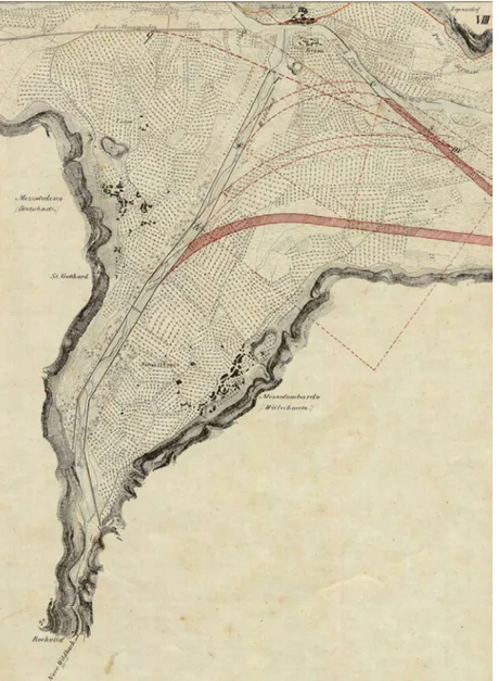
Finally, the sheets I to VII are archived at the Tiroler Landesarchiv in Innsbruck in a version, which is well preserved, and with limited modifications. The sheet VIII is conserved in the Mezzolombardo Municipality library and is worth to mention because two toponyms are written in Italian only and are
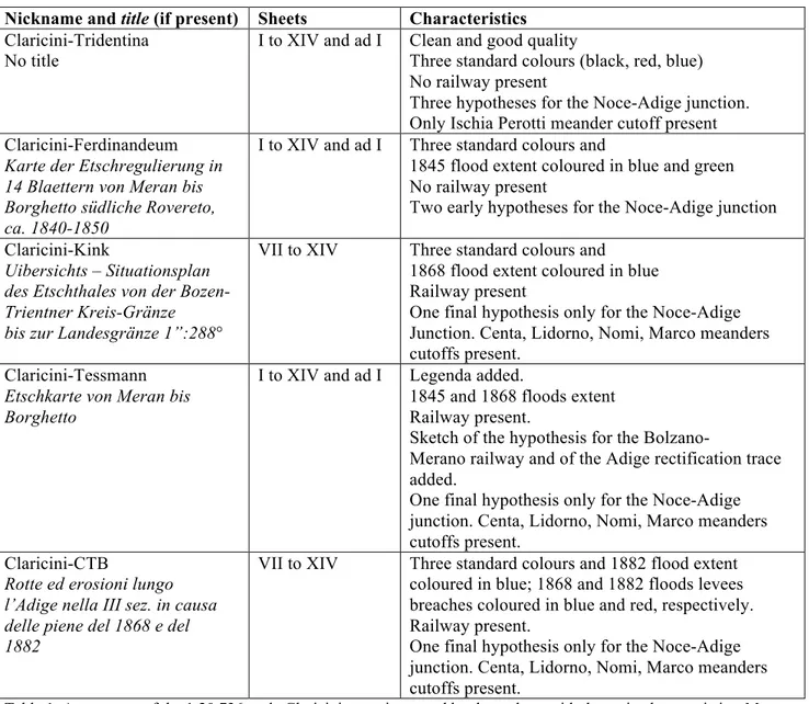
Aristotle University of Thessaloniki [228] Laboratory of Cartography & Geographical Analysis not bilingual as in all the other maps. A summary of the characteristics of the small scale Claricini maps investigated by the authors is reported in Tab. 1
Nickname and title (if present) Sheets Characteristics
Claricini-Tridentina No title
I to XIV and ad I Clean and good quality
Three standard colours (black, red, blue) No railway present
Three hypotheses for the Noce-Adige junction. Only Ischia Perotti meander cutoff present Claricini-Ferdinandeum
Karte der Etschregulierung in 14 Blaettern von Meran bis Borghetto südliche Rovereto, ca. 1840-1850
I to XIV and ad I Three standard colours and
1845 flood extent coloured in blue and green No railway present
Two early hypotheses for the Noce-Adige junction Claricini-Kink
Uibersichts – Situationsplan des Etschthales von der Bozen- Trientner Kreis-Gränze bis zur Landesgränze 1”:288°
VII to XIV Three standard colours and 1868 flood extent coloured in blue Railway present
One final hypothesis only for the Noce-Adige Junction. Centa, Lidorno, Nomi, Marco meanders cutoffs present.
Claricini-Tessmann Etschkarte von Meran bis Borghetto
I to XIV and ad I Legenda added.
1845 and 1868 floods extent Railway present.
Sketch of the hypothesis for the Bolzano-
Merano railway and of the Adige rectification trace added.
One final hypothesis only for the Noce-Adige junction. Centa, Lidorno, Nomi, Marco meanders cutoffs present.
Claricini-CTB
Rotte ed erosioni lungo l’Adige nella III sez. in causa delle piene del 1868 e del 1882
VII to XIV Three standard colours and 1882 flood extent coloured in blue; 1868 and 1882 floods levees breaches coloured in blue and red, respectively. Railway present.
One final hypothesis only for the Noce-Adige junction. Centa, Lidorno, Nomi, Marco meanders cutoffs present.
Table 1. A summary of the 1:20.736 scale Claricini maps inspected by the authors with the main characteristics. More details are reported in the text.
Georeferencing the Claricini map sheets with the 1:10 000 current topographic base map
An objective of a preliminary georeferencing exercise was to compare the metric content of the Claricini map with current topographic base map, in order to assess its potential exploitation for research and technical purposes.
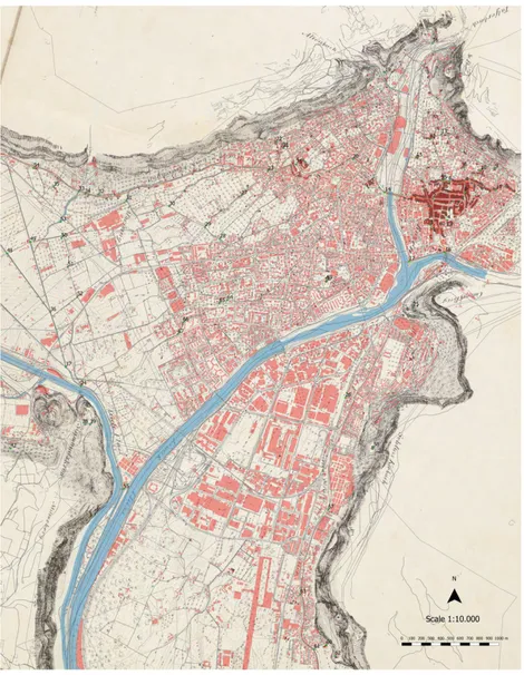
Using a georeferenced framework or a GIS to overlay and project the information enables professionals and researchers to have a geographical database and a geovisualisation useful to support surveys and analyses about land use and topographic changes over time in different areas: urban, agricultural and riverine environments. It is also intended that such a GIS-based approach can contribute to the landscape conservation and protection of an area such as that of the Adige River, which suffered dramatic changes in the last decades. For this georeferencing work the sheet nr. IV of the small-scale 1:20 756 Claricini “Tridentina” map was projected onto the actual 1: 10 000 official base topographic maps (CTP: “Carta Tecnica Provinciale”- Province Technical Map) of the town of Bolzano/Bozen (Fig. 4).
Aristotle University of Thessaloniki [229] Laboratory of Cartography & Geographical Analysis The work of integration of geographical information was conducted by executing a geographic
projection using the open-source Quantum GIS software. This allows the user to assign the Coordinate Reference System (CRS) of the CTP reference map to the historical target source-map through the identification of pairs of common points in both of them. On the two maps analysed easily recognizable landmarks have been identified, such as churches, buildings and bell towers that remained in unchanged positions over time.
The use of an affine transformation of the second order polynomial transformation combined with a nearest neighbour data resampling made it possible to limit the distortions of the georeferenced map within values which take into account both the graphic error, corresponding to about 4 metres, the original accuracy of the historical map, and the deterioration of information resulting from the different steps sustained over time, not least the paper physical degradation and several consequent reproduction procedures including its digitization.
The high number of points identified on both maps for georeferencing (up to 47 GCPs Ground Control Points) and the number of points used for control (20), allowed to reach a level of accuracy of 10 to 15 meters Root Mean Squared Error depending on the number of points used as GCPs for the projection. This error is not very far from that obtained by Dai Prà & Mastronunzio (2014) who georeferenced some sheets of the 1: 3.456 scale version of the Claricini map, also using the Hapsburg Cadastral map sheets (1853-61) as reference (Buffoni et al., 2003), and obtained a RMSE of 5 to 6 metres using 24 GCPs and the same CTP as reference map.
Figure 4. A detail of the sheet nr. IV of the small scale Claricini
“Tridentina” map georeferenced with the most recent 1:10 000 technical map close to the city of Bolzano/Bozen assumed as reference. New urbanized areas are coloured in semi-transparent red. The actual river is in light blue. 78 Ground Control Points used for georeferencing (47) and verification (20) are marked in green.
Aristotle University of Thessaloniki [230] Laboratory of Cartography & Geographical Analysis Worth to notice is the high accuracy in georeferencing the drainage system of the land reclamation area upstream the junction of the Isarco River, on the right of Fig. 4, with the Adige River, on the left. Ground Control Points 36, 37, 48, 49 and the drainage channels are perfectly aligned with the recent topographic map.
If this result were confirmed by georeferencing other map-sheets, we would conclude that the positional and planimertric accuracy of the small scale Claricini map is high enough for technical applications of the map itself, for instance for detecting changes in the landscape, land use or in river morphology over time (Zen & Zolezzi, 2016).
An example of such an application for river engineering studies is given in Fig. 5, reporting a detail of the sheet nr. XII of the edition of the Claricini map conserved at the Consorzio Trentino di Bonifica land reclamation authority.
Figure 5. A sample of the sheet nr. XII of the CTB-Consorzio Trentino di Bonifica edition of the small scale Claricini map with the railway and the sketch of the Besenello, Calliano and Nomi river regulation projects (see also Ranzi & Werth, 2016).
This map is one of the most recent adaptations of the original map, as it is the only one reporting some of the latest hydraulic works on the Adige river, with the exception of those completed between 1887 and 1889 at Ischia (=”island with gravels and vegetation”) Wolkenstein, upstream the town of Trento. This means also that the map was not only a qualitative representation of the valley and river landscape but it had a high technical value also because of its metric accuracy. It is probably one of the last version of technical use of the map, close to the completion of the heavy river regulation works which lasted throughout the XIX century with high expenditures by the public administration, private railways and landowners and citizens (Weber von Ebenhof, 1892b; Ranzi, 2016). Down-stream this reach the river remained almost unchanged until now, with the exception of the Marco meander cut-off, and the comparison with the today’s river position indicates that the morphological river dynamics is relatively
Aristotle University of Thessaloniki [231] Laboratory of Cartography & Geographical Analysis slow. Also the fluvial landscape remained quite preserved there and the value of the Claricini map as a cultural heritage is also because it shows, especially in the southern part of the Adige valley close to the border with the Veneto region, the last remnants of the natural conditions of the river which were dramatically altered elsewhere in the recent decades.
Conclusions
Five versions of the 1:20.736 small-scale version of the map by Leopoldo de Claricini-Dornpacher of the Adige river valley were described. The value of the map sheets as a cultural heritage is also due to the fact that they, more than other contemporary maps including the same 1:3.456 large scale version edited by the same author, provide a synoptic view of the river’s and valley’s landscape as it was in undisturbed conditions. The high accuracy (10 to 15 metres of RMSE) of a preliminary projection of one sheet on a current 1:10.000 scale topographic base map indicates that the Claricini map could also have a technical value providing a metric information about the topographic changes occurred after the mid XIX century as well as about floods events and river morphological changes. Also for this reason the “Claricini-Tridentina” was re-edited as a high quality copy of the original and made accessible to experts and to the public.
Acknowledgments
The Authors acknowledge Regione Autonoma Trentino-Alto Adige/Südtirol, Provincia Autonoma di Bolzano/Bozen, Provincia Autonoma di Trento, the Land Reclamation Authorities “Foce Isarco– Monte/Eisackmündung–Gmund”, “Monte–Salorno/Gmund–Salurn” and “Consorzio Trentino di Bonifica”. Marco Mastronunzio is thanked for having shared knowledge and passion for ancient car-tography over the last four years.
References
Bacchi B., Orlandini S., M. Pellegrini, 2007. Le alluvioni del Po nel secolo XIX: alla ricerca delle cause, in: Ferrari I. e M. Pellegrini (editors), Un Po di carte. La dinamica fluviale del Po nell'Ottocento e le tavole della commissione Brioschi, Edizioni Diabasis, Reggio Emilia, 145-165.
Biszak E., H. Kulovits, S. Biszak, G. Timár, G. Molnár, B. Székely, A. Jankó, I. Kenyeres, 2014. Carto-graphic heritage of the Habsburg Empire on the web: the MAPIRE initiative. Proceedings 9th ICA Workshop on Digital Approaches to Cartographic Heritage, Budapest, 4-5 September 2014, At 26-31, 9, 2014.
Buffoni D., Leoni D. and R. Bortolamedi, 2003. L’eredita’ cartografica catastale degli Asburgo in formato digitale. E.geography: GIS e Società - 6° Conferenza Italiana Utenti ESRI, 9-10 April 2003. Dai Prà E., M. Mastronunzio, 2014. Rectify the river, rectify the map. Geometry and geovisualization of Adige river hydro-topographic historical maps, e-Perimetron, 9(3): 113-128.
Ferrari I., M. Pellegrini (eds.), 2007. Un Po di carte. la dinamica fluviale del Po nell'Ottocento e le tavole della commissione Brioschi, Edizioni Diabasis, Reggio Emilia.
Guerra, F., 2000. 2W: new technologies for the georeferenced visualization of historic cartography. International Archives of Photogrammetry and Remote Sensing 33 (Part B5): 339-345.
Magris C., 1986. Danubio, Garzanti, Milano.
Mastronunzio M., E. Dai Prà, 2016. Who needs Mitteleuropa old maps? Present-day applications of Habsburg cartographic heritage. In Gartner G., Jobst M., Huang H. (eds.), Progress in Cartography, Springer Verlag (Lecture Notes in Geoinformation and Cartography), Berlin: 305-318.
Mastronunzio, E. Dai Prà, 2016. Editing historical maps: comparative cartography using maps as tools, e-Perimetron, 11(4): 183-195.
Aristotle University of Thessaloniki [232] Laboratory of Cartography & Geographical Analysis Mészáros J., 2011. The georeferencing method of the 1:5000 scale Danube maps, Proceedings 6th ICA Workshop on Digital Approaches to Cartographic Heritage, The Hague, 7-8 April 2011: 225-229. Mészáros J., G. Timár, 2010. The Danube Mappation of Hungary (1823-45) and its reprojection to modern map coordinate systems, Proceedings 5th ICA Workshop on Digital Approaches to Car-tographic Heritage, Vienna, 22-24 February 2010: 365-369.
Oberziner L., Claricini-Dornpacher, Leopold von, in: Allgemeines Lexikon der Bildenden Künstler, U. Thieme, F. Becker (eds.), Leipzig, VII: 46.
Pišút P., 2002. Channel evolution of the pre-channelized Danube river in Bratislava, Slovakia (1712– 1886), Earth Surface Processes and Landforms, 27: 369–390.
Pišút P., 2016. Vývoj koryta Váhu pri Leopoldove v 17.-20. storočí, Univerzita Komenského v Brati-slave, 272 pp.
Ranzi R., K. Werth, 2016. Il fiume Adige da Merano a Borghetto nella carta di Leopoldo de Claricini (1847). Die Etsch von Meran bis Borghetto auf der Leopold von Claricini Karte (1847), Tipografia Editrice TEMI, Trento, 56 pp. and 14 annexed coloured plates.
Ranzi R., 2016. Il Fiume Adige a Trento, 1892. La prima carta di rischio idraulico?, L’Acqua, 4-5: 51-60.
Sibra G., 2004. Carta Generale del Fiume Po sulle trace di un progetto cartografico 1821-1872, a cura di G. Sibra, Ufficio Idrografico e Mareografico di Parma, Servizio Idrometeorologico – Arpa Emilia Romagna, Parma.
Tabarelli G.M., 1997. Storia dell’architettura trentina, Temi Editrice, Trento.
Timár G., Molnár G., Székely B., Biszak S., Varga J., A. Jankó., 2006. Digitized maps of the Habsburg Empire – The map sheets of the second military survey and their georeferenced version. Arcanum, Budapest, 59 p.
Weber von Ebenhof A. R., 1892a. Die Etschregulirung in Tirol und Italien. Separat-Abdruck aus der Zeitschrift des Österr. Ingenieur- und Architekten-Vereinis, Nr. 39, Spielhagen & Schurich, Wien. Weber von Ebenhof A. R.,1892b. Der Gebrigs-Wasserbau (Flussregulierung und Hauptschlucht-Verbauung) im Alpinen Etsch-Becken und seine Beziehungen zum Flussbau der oberitalienischen Schwemmlandes. Spielhagen & Schurich, Wien.
Werth K., 2003. Geschichte der Etsch zwischen Meran und San Michele. Flussregulierung, Trocken-legung der Möser, Hochwasserschutz. Tappeiner Verlag (2nd expanded edition, Athesia, 2014), La-na. Zallinger zum Thurm F. von, 1778. De caussis et remediis inundationum in Tyroli dissertatio, Joannis Thomae Typ., Innsbruck.
Zen S., G. Zolezzi, 2016. Utilizzo combinato di mappe storiche e modelli morfodinamici per studiare le traiettorie evolutive di corsi d'acqua soggetti a canalizzazione, Proceedings XXXV Convegno di