Cinzia Fragomeni, Mariangela Musolino, Domenico Enrico Massimo, Antonino Barbalace. Landscape and Settlements. Historic Center Qualitative and Quantitative Valuation
LANDSCAPE AND SETTLEMENTS. HISTORIC CENTER
QUALITATIVE AND QUANTITATIVE VALUATION1
Cinzia Fragomeni Mariangela Musolino Domenico Enrico Massimo Antonino Barbalace University of Reggio Calabria
Abstract. One aim of the research is to mitigate the severe lack of scientific structural
quali-tative and quantiquali-tative knowledge and systemic ancillary information regarding Landscape Elements and Historic Centers of the Country. Methodology has been set up to build-up total and complete knowledge, almost definitive, of landscape Historic Centers resources and set-tlement. It might give possibilities to foster-up preservation, conservation, treasuring, indirect use, of the patrimonies at different geographic levels, increasing the national welfare.
Keywords:1. Multi criteria valuation. 2. Valuation system 3. Historic Centers. 4. Character-istics knowledge. 5 Landscape Elements. 6. Geographic information system.
Introduction
Background debate concerning the future of national and world landscape, his-toric settlements as well as protected areas (such as Grand Canyon) enlists at least two opposite alternative positions: -preservation (oriented to collective consumption) as a mean to promote collective treasuring and enjoyment through indirect use (not private consumption), such as ecological tourism including healthy trekking, and prevent the individual uncontrolled privatization and em-bezzlement of paysage and related soil consumption and damages; -utilitarian direct use of paysage (orientated towards individual consumption) aiming to promote new development in order to generate indirect revenues for local and regional economies through taxation and therefore temporarily helping to avoid recession and unemployment, but at the same time destroying the intrinsic es-sential characteristics of the landscape itself. Since 1985 the Italian legislation (so called “Galasso Law”) has fostered-up a comprehensive landscape planning at the national level regarding the preservation, sustainable collective use of
paysage. Landscape plans (so called: “Piani Paesaggistici Regionali”, i.e., “Re-gional Landscape Plans”), run by re“Re-gional Governments, should have identified, singled out, and enlisted all the Paysage Units (sub regional areas called: “Unità di Paesaggio”, UdP) of the Country, making decision concerning the degree of
1
Attributions: Fragomeni C. authored § 4, 6. Musolino M. authored § 2, 7. Massimo D.E.
their collective preservation and enjoyment vs. individual use, embezzlement, and privatization for development and constructions purposes. It also detected, inventoried, and indexed all landscape individual resources and entities within the boundary of each Paysage Units, assessing and scoring the intensity of em-bodied landscape intrinsic values. Manmade cultural goods such as the Historic Centers (i.e. the original settlement) are included among the landscape re-sources. Today, these in-land Historic Centers are either mainly abandoned or kept in inappropriate conditions for the lack of knowledge, retrofit guidelines, and re-use ideas. The main obstacle to Historic Centers collective treasuring is the persistent lack of: 01.scientific qualitative knowledge of their structural and peculiar characteristics and elements; 02.ancillary data and information about what, where, and how many the Historic Centers are; 03.coherence and homo-geneity of ancillary data among different Districts, Provinces, and Regions of the Country; 04.topographic information about where their original boundaries at key ages are: 1870; 1954. One objective of the research is to mitigate this lack of scientific genetic qualitative knowledge and systemic information about Ital-ian Historic Centres, focusing on specific Regions, Provinces, and Districts, to test both the philosophy and operative methodology proposed in the present re-search. Producing ancillary data (on an experimental field) as well as a qualita-tive hermeneutic interpretation (on a philosophical perspecqualita-tive) might foster up an innovative contribution: a total, coordinated and complete knowledge of landscape resources and namely the subtotal of the Historic Centers, existing in a modular area within a: Town; District; Province; Region. Total and complete knowledge of resources might give possibilities and opportunities to: -unify and coordinate all existing sparse and uncoordinated datasets in a whole coherent in-formation system; -help (thanks to systemic inin-formation, individuals, associa-tions, civil society, Institutions (namely Historic and Landscape Preservation State Authorities: central Ministry; Regional Directorates; Superintendents)) to preserve and treasure landscape values, resources, goods, elements; -support the Regional Planning Authority (in institutional cooperation with Historic and Landscape Preservation State Authorities at the central, regional, and provincial levels) to layout and enforce the Regional Landscape Plan; -in so doing, avoid the destruction of further paysage, historic settlements, and landscape values, because of further construction. In treasuring all Landscape Elements at the Re-gional, Provincial, and District levels a specific category of resources such as Historic Centers has a special relevance because might be the back bone of lo-gistics in organizing sustainable enjoyment of Landscape Intrinsic Indirect Val-ues (not utilitarian) such as: Aesthetic; Wildlife; historical Geo - botanic; Recre-ation; Eco-tourism; EducRecre-ation; Existence; Science; Ecological capital; Ecologi-cal process; EcologiEcologi-cal benchmarks. With regard to the landscape and cultural heritage as a whole and its individual elements, "categorizing the intrinsic indirect values can enable systematic elucidation" and disentanglement of their: -features; -characteristics; -genetic components; -structural composition. The
grasping and knowledge of genetic components of paysage elements helps: -philosophical detection of its structural aspects through index tools; -qualitative valuation and ranking of each single aspect in its specific categories; -preservation; -conservation; -treasuring; -enjoyment.
Aim of the research is therefore to set an almost definitive information system for Historic Centers, as a one special intended original man settlement in the original natural land: - structural knowledge; -quantitative census; -qualitative multidimensional valuation; -remote data diffusion on the Web.
It is possible, for each Historic Center, to plan ahead, design, and manage the levels of their: -preservation; -conservation; -collective non-consumptive use and enjoyment; -private direct use and individual appropriation.
A Case Study is implemented to detect and analyze all the settlements of the large area of a Province (Reggio Calabria), and then to experiment and test the philosophy and methodology proposed in the research.
The almost definitive information system for Historic Centers relies upon the following four pillars that allow a total management of the settlement network. 1. HeritKnow. Step #1: KNOWledge of urban HERITage.
2. HeritUs. Step #2: Total inventory or censUS of urban HERITage. 3. HeritVal. Step #3: Quality VALuation SYSTEM of urban HERITage. 4. HeritWeb. Step #4: WEBGis of urban HERITage.
1. HeritKnow
Step #1. KNOWledge of urban HERITage. Based on selected genetic char-acteristic (criteria) checking and scoring
According to the basics of scientific epistemology, entities of interest (Land-scape Elements; Historic Centers) to be analyzed are knowledgeable “by heart”,
i.e. by a synthetic and informal intuition. An entity can also be known in more formalized terms if it is analyzed and investigated “as a bundle of characteris-tics”. Each characteristic of them can be expressed and qualified by the use of parallel correspondent criteria. Innovation in the present research is that: genetic features or characteristics are also adapted and adopted as criteria to assess cen-ter comparative quality; and it can be scored with valuation practice and utiliz-ing approaches such as Multi Criteria Analysis (MCA). To know more and val-uate Historic Centers at hands, some features \ characteristics \ criteria have been tested in pioneer specific experiences of urban analysis and MCA valuation (Nijkamp, 1988; Fusco Girard, 1992; Massimo, 1995, 1997, 1998, 2002, 2005; Fusco Girard, Nijkamp, 1997; Massimo, Vescio, 2000). Further innovation in the present research, with respect to others (Massimo, 2006), is the increased number of adopted genetic characteristics or valuation criteria. These have been increased from 12 to 14, making more sense and transforming the valuation in a more demanding and complex procedure. Therefore, genetic features \ charac-teristics of historic centers and corresponding criteria used in the present
re-search are 14 and articulated in four scenarios: A. settlement; B. urban; C. archi-tectural; D. cultural \ tourist. It follows a short description of all criteria.
FEATURES \ CHARACTERISTICS AND CRITERIA
A. SETTLEMENT FRAMEWORK
01 A.1 Geographic location and accessibility in the province
Geographic location in the spatial an infrastructural provincial framework. Level of territorial and street accessibility. Higher scores are assigned to better position and accessibility.
02 A.2. Good location and orientation-exposition in the territory
Positive and harmonic relationship between site and overall building and town construction, aesthetic landscape outcome of global construction or “cityscape”, and orientation-exposition. Better territorial location and orientation-exposition, Higher scores are assigned.
03 A.3. Perceived quantitative Historic Center consistency
Quantitative consistency of the Historic Center in terms of perceived physical ex-tension. It makes possible the reasonable comparability between center too differ-ent for typology and dimension. Higher scores are assigned to larger cdiffer-enter.
B. URBAN QUALITY
04 B.1. Urban qualities. Preservation and persistency of original characteristics Harmonic relationship between streets, squares, buildings, and symbolic elements of analyzed center. More harmonic spatial proportions among urban elements, higher scores are assigned.
05 B.2. Dimension and ramification of urban streets
Width, articulation and organicity of urban streets. Higher scores are assigned to streets wide, numerous and in harmonic relationship with urban blocks.
06 B.3. Dimension of urban blocks
Original and present length and width of urban blocks and relation among all blocks, with special positive attention to smaller dimensions. Width of streets in between blocks, better larger than minimum. Smaller or more proportional blocks, higher scores are assigned.
C. ARCHITECTURAL QUALITY
07 C.1. Construction or building technical characteristics
Building original system: materials; techniques; technologies. Valuation of: origi-nal constructive quality; classification of elements; link to provenance site \ locali-ty. More physical quality \ solidity and larger permanence of original materials, higher scores are assigned.
08 C.2. Original architectural characteristics or integrity
Architectural, aesthetic and linguistic features and their permanence and integrity in all buildings, or alterations \ modifications operated by men over time. Score are proportional to aesthetic and architectural integrity and quality. More quality, higher scores are assigned.
09 C.3. Fronts
Building fronts on public spaces such as streets, squares, vistas, belvederes. Bi-dimensional element of urban scenery. Their elements are: proportions; specific aesthetic; shape; materials; colors. Better quality and integration with front spaces, than higher scores are assigned.
10 C.4. Urban spaces and squares
Quality and quantity of urban squares and collective spaces which foster-up meet-ings and call together people. Better quality, higher scores are assigned.
D. CULTURAL \ TOURIST ATTRACTIVENESS
11 D.1. Landscape attractiveness of the historic center
Potential environment and landscape attractiveness and evocativeness of the his-toric center. Higher landscape attractiveness, higher scores are assigned.
12 D.2. Urban attractiveness of the historic center
Attractiveness of historic urban pattern or new plantation scheme \ drawing. More attractiveness, higher scores are assigned.
13 D.3. Relevance or extraordinariness of monuments inside center or monumental characters of the historic center
Building rarity, art objects having artistic features, historical interests, or demo-anthropological importance recognized by: people feelings; or\and experts’ opin-ions; or\and landmark official register or\and roster; or\and scientific publications. Higher relevance, higher score.
14 D.4. Monuments inside historic center
Number, density and level of building having artistic features and historical inter-ests, recognized by: people feelings; or \ and experts’ opinions; or\and landmark official register or\and roster; or\and scientific publications. Higher the number of monuments, higher score.
2. Heritus
Step #2. Total inventory or censUS of urban HERITage, based on historical data and maps
Cornerstones of landscape preservation, Historic Centers conservation and cul-tural treasuring actions should be, first of all, a comprehensive detection and in-ventory of all entities through discovering, description, classification, registra-tion, and, this is new, valuation. The goal is to create an “exhaustive, topograph-ical and thematic inventory” of all the entities as recommended by the Council of Europe (Council of Europe, 2001). It is here named Total Inventory or Total CensUS of HERITage or “heritus”. It is an updated technique that leads to sys-tematic knowledge and numeric assessment of Landscape Elements, namely the category of Historic Centers, behind and above the roster in the State National Register of enlisted entities or properties and the known and published tourist guide (Massimo, 2006). Relevant difference between official roster and “heri-tus” is that the former enlists only the registered masterpieces, instead the latter attempts to detect and quantify through hard desk work all relevant Landscape Elements and original settlements existing and localized in the territory. The technical bases for the total census and account a large number of unpublished (sometime unknown) historical maps and historical population censuses. In par-ticular, among the many available historical maps discovered from abandoned archives, detected, scanned, and georeferenced on GIS, Historic Centers have scientifically been detected thanks to the map called “Carta Generale del Regno
delle Due Sicilie” published in 1829 - 1831 and in second edition in 1852. 3. Heritval
Step #3. Quality VALuation of urban HERITage, based on multi-dimensional assessment of characteristics
It is possible to perform qualitative valuation of Historic Centers in a consolidat-ed framework of well-establishconsolidat-ed discipline of Landscape and Cultural Heritage Appraisal founded by Forte in 1977 and strongly fostered by ICOMOS in 1981 (Forte, 1977; ICOMOS, 1981; Liechfield, 1981; Nijkamp, 1981; Fusco Girard, 1981; Therond, 1981; Mattia, 1983; Amata et alii, 1991). The novelty, in recent years, is that quantitative and cardinal sub-discipline of Economics such as Quantitative Methods and Cultural Econometrics called-up to evaluate urban al-ternative programs, adopting unconventional approaches such as MCA for quali-tative ordinal assessment of landscape ordinal elements and for their consequent hierarchical ranking (Torrisi, sd). As experimented in several previous cited re-searches, specific typologies and generations of MCA approaches (Nijkamp, 1979; Hinloopen, Nijkamp, Rietveld, 1983) have been developed and experi-mented for the peculiar specific purpose (Massimo, 1991; Nijkamp, Finco, 1999). Inside sub-regional clusters of “districts”, a deep knowledge is required about each single Historic Center to understand genetic features and characteris-tics, related values, tourism potentialities, in a relative hierarchical form, and to grasp possible future re-uses and revitalization in a rank order. For each center, each valuator writes down a heuristic and intuitive assessment, i.e. a Report de-scribing: 1. general intuitive value or quality; 2. special attractors; 3. effective level of conservation vs. (and) critical conditions; 4. intuitive potentialities for economic revitalization. Qualitative data have been processed to understand la-tent relationships and detect lala-tent implicit variables, relying upon: robust ordi-nal qualitative statistics (Hinloopen, 1985; Hinloopen, Nijkamp, 1986); experi-mented methodology (Coccossis, Nijkamp, 1995; Fusco Girard, Nijkamp, 1997); specific Case Studies applied in the same region (Massimo, 1991, 1995, 1997, 2002, 2005, 2006; Massimo, Vescio, 2000). MCA process provides a rank order of evaluated Historic Centers.
4. Heritweb
Step #4. WEBGis of urban HERITage, available for both consultation and remote valuation
Understand by knowledge (“heritknow”), census (“heritus”), and analytical val-uation (“heritval”) can be made available to potential users via Web, enlarging dramatically its service, diffusion, and efficacy. This capital of knowledge can be accessible by structuring an Internet service for both uses: consultation for general public; appraisal and valuation support and performances for analysts,
evaluators, and experts (Massimo, Barbalace, Mercuri, 2005). The subsequent step, after GIS building-up, is the transfiguration in a Web site accessible to ana-lysts, evaluators, experts and other general users. Consequently: for remote use and fruition by general users “Hyper Atlas GIS of Historic Centers” will be transformed in WebGIS; and for appraisers will be transformed in a valuation GIS, i.e. General information System (GiS) for Valuation and Appraisal (EvA), or GiS.EvA, in Italian SGV.
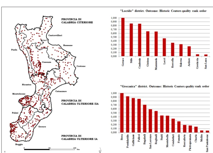
5. Case study at large level of province territory
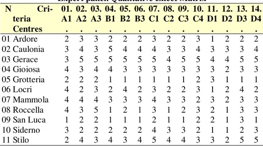
The hardest Case Study tries to answer the most demanding Institutional re-quest: to detect, inventory, select, visit directly, score and rank the most promi-nent and highest potential Historic Centers of the whole province of Reggio Calabria. Key choice in this first and pioneer experiment is the subdivision of the province in sub-provincial areas called historic “districts”. The latter repre-sent territories having cultural identity and geographic homogeneity. Ranking of centers belongs to separate districts and this gives a lot of sense to the interpreta-tion of final results. Valuainterpreta-tion has been performed for two sub-provincial his-toric districts, called: “Grecanica” and “Locride”. Given the high number of set-tlements in “Locride” district, from the list have been selected the pivotal vil-lages called: “capoluoghi di mandamento”. Then, original settlements to be ana-lyzed and valuated, in the two historic districts, are: Locride district: 01.Ardore; 02.Caulonia; 03.Gerace; 04.Gioiosa; 05.Grotteria; 06.Locri; 07.Mammola; 08.Roccella; 09.San Luca; 10.Siderno; 11.Stilo. Grecanica district: 01.Bagaladi; 02.Bova; 03. Chorio; 04.Condofuri; 05.Fossato; 06.Gallicianò; 07.Melito; 08.Montebello; 09.Palizzi; 10.Pentidattilo; 11.Pietrapennata; 12.Roccaforte; 13.Roghudi; 14.San Lorenzo; 15.San Pantaleone; 16.Staiti. The demanding tour allowed both the scoring according to methodology, and a relevant innovation. It is the check by written report and picture documentation about the blight and decay of settlements and their architectures. This is the first documented moni-toring act sub-sequent analytic and evaluative research. In this phase, an evalua-tion team, well trained, compiles the Quantitative Effect Matrix, i.e. the charac-teristics \ criteria scores as basis for ordinal statistics hierarchy assessment.
Table 1. Calabria Region. "Locride" District. Multi Criteria Valuation of Historic Centers.
Expert panel. Qualitative Effect Matrix N Cri-teria Centres 01. A1 . 02. A2 . 03. A3 . 04. B1 . 05. B2 . 06. B3 . 07. C1 . 08. C2 . 09. C3 . 10. C4 . 11. D1 . 12. D2 . 13. D3 . 14. D4 . 01 Ardore 2 3 3 2 2 2 3 2 2 3 1 2 2 2 02 Caulonia 3 4 3 5 4 4 4 3 3 4 3 3 3 4 03 Gerace 3 5 5 5 5 5 5 4 5 5 4 4 5 5 04 Gioiosa 4 3 4 4 3 3 3 3 3 3 3 2 3 3 05 Grotteria 2 2 2 1 1 1 1 1 1 2 3 1 1 1 06 Locri 4 2 3 2 4 2 3 2 2 3 1 2 4 2 07 Mammola 4 4 4 3 3 3 4 3 3 2 3 2 3 3 08 Roccella 4 3 5 1 2 1 3 1 2 3 2 1 3 3 09 San Luca 1 2 2 1 1 1 2 1 1 2 2 1 3 1 10 Siderno 3 2 2 2 2 2 4 3 3 2 1 1 2 3 11 Stilo 2 4 3 4 3 4 5 4 4 3 3 2 5 5 Table 2. Calabria Region. "Grecanica" District. Multi Criteria Valuation of Historic Centers.
Expert panel. Qualitative Effect Matrix N Criteria Centres 01. A1 . 02. A2 . 03. A3 . 04. B1 . 05. B2 . 06. B3 . 07. C1 . 08. C2 . 09. C3 . 10. C4 . 11. D1 . 12. D2 . 13. D3 . 14. D4 . 01 Bagaladi 3 2 3 2 3 2 2 2 2 4 2 2 3 3 02 Bova 3 4 4 4 4 4 4 3 3 3 3 4 4 5 03 Chorio 4 3 3 3 2 2 2 2 2 3 2 2 1 1 04 Condofuri 2 3 4 1 3 1 2 1 1 2 1 1 1 1 05 Fossato 2 2 4 1 3 3 2 1 1 2 1 2 2 2 06 Gallicianò 3 4 1 3 3 2 4 3 3 4 5 4 4 2 07 Melito 5 4 5 3 3 2 2 2 1 2 2 3 2 4 08 Montebello 3 3 3 2 3 1 3 2 2 1 2 2 1 1 09 Palizzi 2 3 4 3 2 3 3 2 2 2 5 2 3 3 10 Pentidattilo 4 4 2 2 2 1 4 2 2 1 5 2 4 1 11 Pietrapennata 2 2 2 3 2 1 2 1 1 2 2 2 2 1 12 Roccaforte 1 3 2 3 2 2 2 2 2 1 2 2 1 1 13 Roghudi 1 3 1 3 2 2 2 3 2 2 4 3 1 1 14 San Lorenzo 3 2 4 3 3 2 3 2 2 5 2 3 3 3 15 San Pantaleone 3 2 3 1 2 1 2 2 2 2 1 1 1 1 16 Staiti 2 2 4 3 2 2 2 1 1 3 2 2 4 2
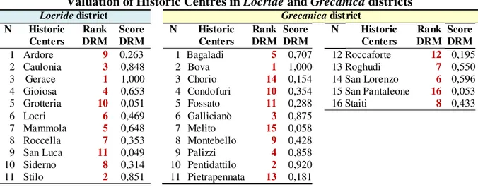
6. Running Multi Criteria Valuation through Dominant Regime Method Software runs the autonomous Qualitative Effect Matrices, and the main unified Qualitative Effect Matrix. Outcome is the ranking of all Historic Centers accord-ing to scoraccord-ing activity of Evaluator Panel articulated per district. The under cov-ered process is managed by a Senior Evaluator Master or Coordinator that checks for coherence the first results of few initial runs, before the definitive
one. The personal skill of each Evaluator is improving because all of them are called up to write down, in secret mode, a personal heuristic final ranking of all the settlements they are going to score up in numerical expression. Afterwards, Senior Valuation Master or Coordinator promotes bilateral meetings with each Evaluator, commenting final analytical outcomes with heuristics, trying to un-derstand differentials. Final results are in the following table and in the figures.
Table 3. Valuation of Historic Centres in Locride and Grecanica districts
Locride district Grecanica district
N Historic Centers Rank DRM Score DRM N Historic Centers Rank DRM Score DRM N Historic Centers Rank DRM Score DRM 1 Ardore 9 0,263 1 Bagaladi 5 0,707 12 Roccaforte 12 0,195
2 Caulonia 3 0,848 2 Bova 1 1,000 13 Roghudi 7 0,550
3 Gerace 1 1,000 3 Chorio 14 0,154 14 San Lorenzo 6 0,596
4 Gioiosa 4 0,653 4 Condofuri 10 0,354 15 San Pantaleone 16 0,053
5 Grotteria 10 0,051 5 Fossato 11 0,288 16 Staiti 8 0,433
6 Locri 6 0,469 6 Gallicianò 3 0,875
7 Mammola 5 0,648 7 Melito 15 0,058
8 Roccella 7 0,353 8 Montebello 9 0,428
9 San Luca 11 0,049 9 Palizzi 4 0,858
10 Siderno 8 0,314 10 Pentidattilo 2 0,920 11 Stilo 2 0,851 11 Pietrapennata 13 0,181
7. Conclusion
One aim of the research is to mitigate the severe lack of scientific structural qualitative knowledge and systemic ancillary information concerning landscape. Research has set and tested an almost definitive information system for land-scape complex system, starting from Historic Centers as a one special category intended as original men settlement in the original natural land. In fact, information is the key element to support landscape resource and Historic Center: -structural knowledge; -quantitative census; -qualitative multi-dimensional valua-tion; -remote data diffusion on the Web. Grasping and knowledge of genetic characteristics and components of paysage elements and of Historic Centres helps: philosophical detection of its structural aspects through index tools; -qualitative valuation and ranking of each single aspect in its specific Categories through multidimensional valuation; -preservation, through Regional Landscape Plan and other specific tools; -conservation; -treasuring; -enjoyment. Valuation of landscape and original settlement elements is performed considering genetic features of resources as criteria for qualitative assessment of Intrinsic Existence Values as basis to derive a rigorous value ranking and therefore a corresponding degree of priority for: -planning; -protection; -intervention; -marketing of each entity within the double coordination of respective categories and space of sub regional “Landscape Unit”. Research outcomes are the basis of systemic infor-mation that help individuals, associations, civil society, Institutions (namely His-toric and Landscape Preservation State Authorities: central Ministry; Regional
Directorates; Superintendents) to preserve and treasure landscape values, re-sources, goods, elements, with an ordered, scientific and rigorous hierarchy and priority ranking. Research kept the promises by building a complete, almost de-finitive, knowledge framework and web information system giving a systemic set of tools for landscape integral treasuring.
Summary
One aim of the research is to mitigate the severe lack of scientific structural qualitative knowledge and systemic ancillary information concerning landscape complex system, starting from Historic Centers as one special category, intended as original men settlement in the original natural land. Research has set and tested an almost definitive information system, in fact, information is the key element to support landscape resources and Historic Center: -structural knowledge; -quantitative census; -qualitative multi-dimensional valuation; -remote data diffusion on the Web. Grasping and knowledge of genetic components of paysage elements and of Historic Centres helps: philosophical detection of its structural aspects; -qualitative valuation and ranking through multi-dimensional valuation; - preservation, through Regional Landscape Plan; -conservation; -treasuring. Valuation of landscape and original set-tlement elements is performed considering genetic features of resources for qualitative as-sessment of Existence Values. Research outcomes are the basis of systemic information that help individuals, associations, civil society, Institutions to preserve and treasure landscape values, resources, goods, elements, with an ordered, scientific and rigorous hierarchy and pri-ority ranking. Research kept the promises by building a complete knowledge framework and web information system giving a systemic set of tools for landscape integral treasuring.
Bibliography
1. Amata G., & Zizzo N., & D’Agata D., & Romano M., & Parlagreco S., & Giannini G., & Scarani M. (1991). Il messaggio della memoria. C.U.E.C.M., Catania.
2. Coccossis H., & Nijkamp P. (ed) (1995). Planning for Our Cultural Heritage. Avebury Publisher. Aldershot (England), Brookfield (Usa), Hong Kong, Singapore, Sydney. 3. Council of Europe, Cultural and Natural Heritage Department (2001). Guidance on
in-ventory and documentation of the cultural Heritage. Strasbourg, France.
4. Forte C. (1977). Il valore di scambio e valore d' uso sociale dei beni culturali
immobilia-ri. 30.06.1977. Napoli. Mimeo [Published in: Restauro, n. 35 (1978), pp. 99-105].
5. Fusco Girard L. (1981). Le strategie di conservazione delle risorse
architettoni-che/ambientali/culturali. Icomos, Napoli.
6. Fusco Girard L. (1992). La valutazione delle risorse architettonico-culturali. Aestimum. Ottobre, pp. 153-164.
7. Fusco Girard L., & Nijkamp P. (ed) (1997). Le valutazioni per lo sviluppo sostenibile
del-le città e del territorio. Franco Angeli, Milano.
8. Hinloopen E. (1985). De Regime Metode. Doctoraalscriptie. Interfaculteit Actuariaat en Economie, Vrije Universiteit, Amsterdam, 25 april 1985 [The Regime Method. Master Thesis]. Unpublished.
9. Hinloopen E., & Nijkamp P. (1986). Qualitative Multiple Criteria Choice Analysis: the
Dominant Regime Method. Research Memorandum, Free University, Amsterdam.
10. Hinloopen E., & Nijkamp P., Rietvelt P. (1983). Qualitative Discrete Multicriteria Choice Models in Regional Planning. Regional Science and Urban Economics, n. 13, pp. 77-102 11. ICOMOS (1981). Economic Analysis for Choosing Priorities in a Conservation Strategy.
Naples. Mimeo.
12. Liechfield N. (1981). Economic analysis for choosing priorities in a conservation
strate-gy. Icomos, Napoli.
13. Massimo D. E. (1991). Environmental and Historic Preservation, Economic
Develop-ment, Social Decision Analysis. Master Thesis Proposal. Dep. of Economics. Dep. of Ur-ban Studies and Planning. Massachusetts Institute of Technology. Cambridge, Ma, Usa. 14. Massimo D. E. (1995). Heritage conservation economics: a case study from Italy. In:
Coccossis H., Nijkamp P. (ed) Planning for Our Cultural Heritage. Avebury, Aldershot (England) – Brookfield (Usa) – Hong Kong – Singapore –Sydney, pp. 171-189.
15. Massimo D. E. (1997). Valutazione multidimensionale dei beni culturali: il Castello di Nicastro. In: Fusco Girard L., Nijkamp P. (eds) Le valutazioni per lo sviluppo sostenibile
della città e del territorio. Studi urbani e regionali. FrancoAngeli, Milano: pp. 388-418. 16. Massimo D. E. (1998). Economia della Conservazione Culturale. Conservazione
integra-ta e interdipendenze economiche. Pagine di Estimo. Quaderni del Dipartimento
Patrimo-nio Architettonico Urbanistico. Università degli Studi di Reggio Calabria, Gangemi Edi-tore, n. 13-14, pp. 29-42.
17. Massimo D. E. (2002). Valutazione multidimensionale dei centri storici per lo sviluppo economico territoriale. Pagine di Estimo. Quaderni del Dipartimento Patrimonio
Archi-tettonico Urbanistico. Università degli Studi di Reggio Calabria, n. 19-20, Inserto pp. 21-35.
18. Massimo D. E. (2005). Today GIS Management of Urban Risk Based upon one of the Forerunner GIS of History (1828). Poster. Proceedings of the 25th ESRI International User Conference 2005. GIS helping manage our world. San Diego, California, Usa, 25-29.07.2005. ESRI Press, Redlands, California, Usa. CD-Rom.
19. Massimo (2006). Valutazione dell’insediamento storico per la valorizzazione e lo svilup-po sostenibile. Stima tassonomica e valore culturale. Quaderni del Dipartimento
Patri-monio Architettonico e Urbanistico. Università degli Studi Mediterranea di Reggio Cala-bria. Gangemi Editore, Roma, n. 29-32: pp. 451-478.
20. Massimo D. E., & Barbalace A., & Mercuri A. S. E. (2005). Valutazione in remoto dei beni culturali e ambientali con l’ausilio del WebGIS. Atti della Nona Conferenza Nazio-nale ASITA. Federazione delle Associazioni Scientifiche per le Informazioni Territoriali
ed Ambientali. Catania, 15-18.11.2005. Asita, Milano, volume II, pp. 1475-1480.
21. Massimo D. E., & Vescio M. (2000). Crescita regionale e riqualificazione urbana. Politi-che per i centri storici in Calabria. In: Atti della XXI Conferenza Italiana di Scienze Re-gionali, Crescita regionale e urbana nel mercato globale. Palermo-Mondello, 20-22.09.2000. AISRe, Palermo. CD-Rom.
22. Mattia S. (1983). Appunti sulla stima del valore sociale dei beni culturali immobiliari. Cooperativa Studenti di Architettura, Milano.
23. Nijkamp P. (1979). Multidimensional Spatial Data and Decision Analysis. Wiley, New York.
24. Nijkamp P. (1988). Culture and Region: a multidimensional valuation of monuments.
Environment and Planning B, n. 15, pp. 6-15.
25. Nijkamp P. (1981). Ancient cities in transition: a socio-economic valuation framework.
Icomos, Napoli.
26. Nijkamp P., & Finco A. (1999). Valuation of Complex Resilience Strategies for
Sustain-able Cities. Paper presented at XIX Incontro di Studio del Ce.S.E.T, Centro Studi di E-stimo ed Economia Territoriale, Padova, 08.10.1999. Mimeo.
27. Nijkamp P., & Vreeker R. (2000). Sustainability Assessment of Development Scenarios: Methodology and Application to Thailand. Ecological Economics, n. 33, pp. 7-27
29. Torrisi B., sd. La valutazione dei progetti pubblici per il recupero urbano. Un modello statistico multicriteriale. Settore Statistica Economica. Dipartimento di Economia. Uni-versità degli Studi di Catania.
30. Vreeker R., & Nijkamp P., & Ter Welle C. (2001). A Multicriteria Decision Support
Methodology for Evaluating Airport Expansion Plans. Tinbergen Institute Discussion Paper, Amsterdam. Mimeo.
Figures
Figure 1. Calabria Region. Historical provinces and district. Detection of 694 centers at 1851. Quality rank order bar-graph. Locride and Grecanica Historic Centres.
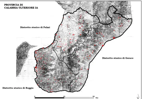
Figure 2. Calabria Region. Province of Reggio Calabria. Mark out of 202 centers at 1870. Basemap: topographic map at 1870
Figure 3. Calabria Region. Province of Reggio Calabria. Historic Centers overlapping at 1870 (red) and 2001 (yellow). Basemap: 1870 topographic map; 1991 census map
Cinzia Fragomeni Department of PAU
University of Reggio Calabria, Italy E-mail: [email protected]
Mariangela Musolino Department of PAU
University of Reggio Calabria, Italy E-mail: [email protected] Domenico Enrico
Massimo
Department of PAU
University of Reggio Calabria, Italy E-mail: [email protected]
Antonino Barbalace Department of PAU
University of Reggio Calabria, Italy E-mail: [email protected]