contrast, the subsequent high-angle normal faulting affected the entire tectonic pile, truncating all the pre-existing, inherited structures. The high-angle normal faulting produced hundreds of metres of cumulate offset as demonstrated by the down-throwing of the low-angle normal fault at the base of the Serritello relief (Fig.8a), whose possible prosecution can be found east of Monte Volturino, at the base of the Madonna di Monte Saraceno isolated outcrops of platform carbonate rocks (Fig.7d). The same high-angle normal fault also cuts across the Monte Volturino fold, which was down thrown toward SW of about 600 m, where the same structure is recognisable in the SW face of the Monte Corno relief (Fig.3d). The stop offers also a scenic view of the opposite margin of the High Agri Valley, which is dominated by the platform carbonate rocks of the Monti della Maddalena ridge, ranging in elevation between 1000 and 1300 m. The same rocks constitute the Monte di Viggiano massif, where the present stop is located, which has a maximum elevation of 1727 m, about 1000 m higher than the Agri alluvial plain. Under the Agri alluvial plain, the platform carbonate rocks are found in boreholes under the continental infill, at a depth ranging between 300 and 600 m under the topographic surface. This means that the High Agri Valley boundary faults record a maximum cumu-lative throw ranging between 1200 and 1600 m, respectively, estimated for the fault system bounding the valley toward the west and the east.
From Low-Angle to High-Angle Normal Faulting (Stops 10a, 10b and 11—Serritello, Sorgente Copone, Barricelle)
Location and Aim The stops are located in the Marsico Vetere area (Fig.8a), where different fault systems with extensional and transtensional kinematics, and their crosscutting relation-ships, are particularly evident and well exposed. The stop 10a illustrates outcrop-scale, east-dipping low-angle tectonic con-tacts in the sediments of the Apennine platform domain. The stop 10b shows two high-angle fault systems and their cross-cutting relationships. The stop 11 provides insight into the most recent faulting episode recognised along the Marsico Vetere fault array.
Outcrop Description The stop 10a illustrates the low-angle tectonic contacts cutting rocks of the Apennine platform do-main, and developed primarily at the boundary between the Jurassic limestone and the Triassic dolomite, which results in a “younger-on-older” tectonostratigraphic relation (Bucci et al. 2012). Cataclastic zones are well developed in the dolomite rocks and locally exceed a few tens of metres in thickness. The cataclastic shear zones are associated with, and represent ev-idence for, the presence of east-dipping low-angle tectonic contacts (Fig.8b). The tectonic contacts are low-angle (20°– 40°), NE-dipping fault zones. Kinematic indicators on the fault surfaces include primary corrugations and asymmetrical
dome structures with a long axis parallel to the transport di-rection, and slickensides (Bucci et al.2014), both in the hang-ing wall and in the footwall blocks. Analysis of the kinematic indicators reveals a NE, top-down displacement along shallow shear zones. Based on these lines of evidence, these structures have been interpreted as low-angle normal faults that are com-monly developed in an extensional regime (Novellino et al. 2015; Brozzetti2011).
The stop 10b shows two younger fault systems, respective-ly, trending NE-SW and NW-SE, cutting across and clearly offsetting the older low-angle normal faults. Several expo-sures of NE-SW-trending normal faults are located between Monte Volturino and Il Monte di Viggiano, and define a morphostructural depression named Sorgente Copone graben. Two main normal faults, the Pietra Liscia fault (Fig.8c) and the Marsico Vetere fault, respectively, bound to the north-west and to the south-east of the Sorgente Copone graben for a length of about 4 km. Southward, both faults terminate against the eastern border fault of the High Agri Valley and are cov-ered under the Quaternary breccias and sediments. Northwards, they terminate against the uppermost strand of the East Val d’Agri Fault System (EAFS; according to Bucci et al.2013). Both the Pietra Liscia fault and the Marsico Vetere fault have been dissected in several segments by Quaternary NW-SE oblique-to-strike slip faults with left-lateral kinemat-ics. The fault system strongly affects roughly stratified talus breccias of early-to-middle Pleistocene age (Di Niro et al. 1992), which appear faulted against the Mesozoic bedrock (Fig.8d).
The stop 11 is located in an abandoned quarry along a fault strand close to the valley flat, belonging to the NW-SE-trending high-angle fault system. The faults are marked by 10–20-cm-thick cataclastic shear bands and by a polished and planar slip surface. Two sets of slip lineations are ob-served on these surfaces. The first set indicates left-oblique slip on northwest-striking surfaces and characterises the main fault morphology and presumably the larger slip accommo-dated by the fault. The second set of slip lineations indicates dip-slip motion. The second slip event is marked by short (dm-scale) and variably developed lineations, which are os-tensibly superposed on the first set and on the main fault morphology, though without erasing the imprint of the older motion. It is likely that these slips occurred in the near surface in recent times. As a matter of fact, on the topographic surface, the traces of one of such reworked faults are locally document-ed by a sub-metric-scale step in the slope profile suggesting active deformation in very recent time (Fig.8e).
Fault-Controlled Hydrocarbon Migration (Stop 12—Tramutola Pool)
Location and Aim This is the last stop of the itinerary. It is located close to the Tramutola Pool, along the west margin of
the High Agri Valley, few kilometres S of the first geosite of the itinerary. The stop is designed to show an oil superficial manifestation, resulting by the migration of hydrocarbon in the vertical direction along fault-related fractures and hydrau-lic connections.
Outcrop Description The natural hydrocarbon springs of the Tramutola Pool geosite are liquid manifestations. They consist of a free drip of oil due to the rising from shallow levels (the superficial reservoir is about 300– 400 m deep) along rock fractures. Oil is associated with water and natural gas (mainly methane, carbon dioxide and hydrogen sulphide). The natural hydrocarbon springs consist essentially of oil more or less oxidised that do not evaporate, dark or blackish, very viscous or even pasty (Van Dijk et al. 2013). Such spontaneous manifestations are evident at the confluence of the Torrent Fossatello and the Rio Cavolo, few hundred metres west of the Tramutola Pool. They are found within marly-arenaceous silicoclastic terrains, near the tectonic contact with the Mesozoic apenninic platform carbonate, that form the hill on the west bank of the stream. The hydrocarbons and sulphidic water mix with the clean water of the stream until it enters the main stream of the Rio Cavolo (Fig. 8f), a tributary of the Agri river, which contributes to the recharge of the ar-tificial Pietra del Pertusillo lake. Apart the scientific and education values, this geosite is historically important, since, during the first half of the ‘900, the growing interest around the Tramutola oil spring triggered the first hydrocarbon exploration activities in the High Agri Valley, targeting the scattered, mainly unproduc-tive, superficial oil traps. Only after the exploration of the deep oil traps, at the beginning in the 1980s, the richness of the hydrocarbon resource in the subsoil of the Agri Valley was demonstrated.
Discussion
Scientific and Touristic Motivations for the Geological
Itinerary
The complete geological history of the Southern Apennines of peninsular Italy can be reconstructed through observations carried out at sparse outcrops across the orogenic system. Only occasionally it is recorded within, and can be inferred from, analysis of rather exceptional, single, metric outcrops (e.g. see Tavarnelli and Prosser2003; Tavarnelli et al.2003). In addition to these rare situations, the geological heritage across the looping route of the itinerary described above rep-resents a wellspring of knowledge on the geological history of the Southern Apennine chain, as it makes it possible to
recognise and analyse in great detail several structures of dif-ferent ages and scales, from mesoscopic to macroscopic, re-lated to the main tectonic events that shaped the geological foundation of Southern Italy; these include pre-orogenic ex-tension related to the Mesozoic rifting events, the Neogene orogenic contraction and the Quaternary late/post-orogenic strike-slip events that were followed by extensional deforma-tions responsible for recent uplift and for intense seismic ac-tivity of the area. Compared to known examples of geological itineraries scattered elsewhere around the world, our itinerary has the peculiarity to illustrate the cyclical, recurrent character of the geological processes, their role in shaping the natural landscape and their interaction with the human impact. These issues are rarely addressed by geological itineraries (Bentivenga et al.2017), which commonly link geosites shar-ing particular characteristics. The most represented itineraries in the geological literature include the following: (i) geosites of the same origin and type (Migoń et al.2018; Bertok et al. 2015); (ii) geosites located in the same parks or protected area (Costantini et al.2015a; Balestro et al.2016); (iii) geosites of city, province and region (Pica et al.2016; Costantini et al. 2015b); (iv) geosites placed along historical (Niculiţă and Mărgărint2018) and cultural paths (Sabato et al.2018).
The present geological itinerary consists of 17 stops at as many geosites, which preserve remarkable evidence for past deformation events and allow the visitor to recompose the tectonic puzzle that led to the growth of a mountain belt from a marine environment, to its emersion and, later, to its dissec-tion and collapse to achieve its present-day physiography. The geosites contain multiple geological information, including structural, stratigraphic and geomorphological ones. Several recent research papers are based on these information, provid-ing a documentation of the scientific value of these geosites. In addition, the itinerary interconnects with other geological field trip routes in the High Agri Valley. It seems appropriate to stress here that field trip routes and geological itineraries across the High Agri Valley were designed and/or accom-plished as parts of international congresses and conferences open to stratigraphy, palaeontology, geomorphology, structur-al geology, seismology, archaeology and hydrocarbon experts (e.g. see Ferranti et al.2007), or of more general educational programmes of geoscience schools, documenting the interest of broad, varied and multidisciplinal communities on the area, as well as the educational value of the visited geosites.
The itinerary also presents a number of non-geological is-sues that yet, coupled with the remarkable geological interest of the area, will hopefully and potentially result in positive feedback on geotourism.
(I) Trip (Fig.2) may be done by car, going round the Monte Lama–Monte Volturino ridge clockwise, including short but delightful walking tours. Geosites 1a, 1b, 2, 3a, 4a, 4b, 6, 8, 11 and 12 are exposed along the paved road;
geosites 5, 7 and 10a are reachable following a secondary road. Geosites 3b, 9 and 10b can be reached in 15 min thanks to well indicated walkways or pathways. (II) Risk conditions along the route of the itinerary are
ex-tremely reduced. These are limited to the sites 3b (Fig. 4c) and 4b (Fig.5b), where tens of metres of high rocky walls exposing sub-vertical rock beds and layers are prone to rockfall and toppling. Further potential risk conditions are limited to the vertical rock walls of sites 10b (fault planes, Fig. 9a), 10a and 11 (dismantled quarries, Fig.9b) and along the trails approaching site 10b (rockfall, Fig.9c) and site 7 (rockfall, Fig.9d). At these locations, it is recommended to avoid leaving the main, indicated path during the visit, and to avoid climbing, maintaining a safe distance of a few metres from the vertical rocky walls.
(III) Several geosites geographically coincide with sites of cultural and natural heritages. Geosites 7 and 9 coincide with notable places of worship and reli-gious architecture: the church of Madonna di Monte Saraceno and the sanctuary of Madonna di Monte di Viggiano (Fig.10a), which is considered one of the symbols of the historical and cultural identity of the Basilicata region. The sanctuary is located at the top of the Monte di Viggiano, at the end of a delightful, steep walkway offering spectacular view points (Fig. 10b). Geosites 10a and 10b rest just in front (and few hundreds of metres far) to the archaeologi-cal site of La Civita, displaying the ruin of a palaeo-Christian temple (Fig.10c). Moreover, in the oppo-site (western) side of the valley, the Roman town of Grumentum (Fig.10d) is located just few kilometres so ut h of the ge os ite 1 2. Gru men tu m i s al so
overlooking the Pietra del Pertusillo lake (Fig.10e), which is one of the main naturalistic attractions of the High Agri Valley.
(IV) The itinerary develops within the territory of the Appennino lucano val d’Agri Lagonegrese National Park, and many geosites are located along the official trails (Fig.10f), which cross the most interesting natu-ralistic areas of the park.
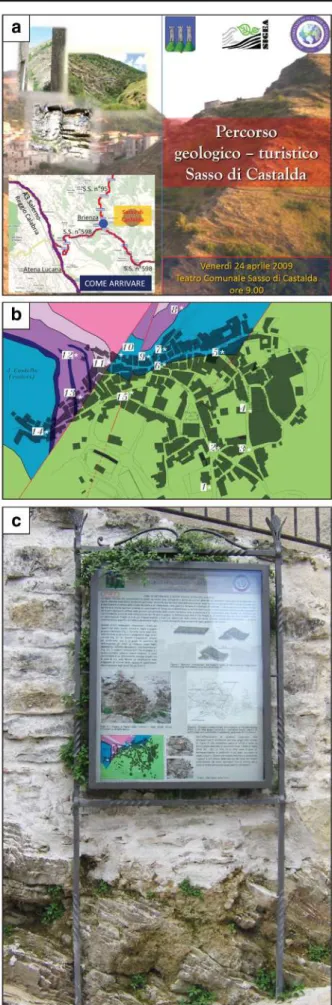
Overall, the coincidence of sites of relevant geological interest with other natural and cultural heritage sites is vital for educational purposes, as they offer a firsthand way for people to approach the world of geology through integrated itineraries, exploring the geodiversity and its interconnection with the natural and cultural heritages (Coratza et al. 2016). Despite its potential for geotourism, the geological itinerary here presented is marginal respect to the main geotouristic routes of the Southern Apennine (e.g. Cilento e Vallo di Diano Geopark) and remains unknown to the visitors of the Appennino lucano Val d’Agri Lagonegrese National Park due to the lack of adequate information for non-specialists. Parallel to the scientific characterisation of the geosites along the itinerary, we acknowledge the need to promote their edu-cational contents through outreach activities. For example, we consider the strategy adopted for the promotion of the geolog-ical itinerary of Sasso di Castalda (PZ), 10 km north of the High Agri Valley (Palladino et al.2013). The itinerary was inaugurated in 2009, through a public meeting (Fig. 11a), followed by a walk along a path through the sites of geological interest (Fig. 11b). Explicative panels showing the relevant geological features of the geosites were placed at each stop and are still present in good condition (Fig.11c). In the Sasso Fig. 9 Risk conditions along the
post-orogenic extensional fault arrays on the NW margin of the High Agri Valley, at the foot of the Mt. Volturino-Mt. Torrette-Madonna di Monte Saraceno carbonatic ridge. a Steep fault surface exposed at Sorgente Copone graben, at geosite 10a. b The dismantled Arenata quarry walls, at geosite 11. c Rockfall along a trail of the itinerary at Sorgente Copone. d Rock avalanche at the foot of the Madonna di Monte Saraceno sanctuary, corresponding to the geosite 7
di Castalda case, the cooperation between university, local associations and municipality has guaranteed high educational and scientific standards, active citizen involvements and the long-term maintenance of the panels. The example of Sasso di Castalda can be followed to promote the geological itinerary of the High Agri Valley, also opening at further initiatives as (i) the publication of a field trip guide, (ii) the publication of the trail map and (iii) the digital development of the trail tracks and their geological contents, making them suitable for mobile technologies. However, the designing and realizing of geoheritage promotion actions should be subordinated to a scientific agreement, that is lacking at the moment, with the Appennino lucano Val d’Agri Lagonegrese National Park au-thority and other subjects in charge of regional and local land management.
Geosites as a Tool for Enhancing the Geological
Education to Natural Hazards
It is essential to keep in mind that to forge a connection be-tween the visitors and the object visited, it is crucial to relate
what is shown with something in the personality or experience of the visitors (Rabal-Garcés et al. 2017), for instance, by using examples taken from everyday life. This transforms the object visited into something closer to their own human experience and thus makes it more meaningful to them. Several geosites included in the geological itinerary give the opportunity to discuss common human experiences of geolo-gy, represented by geological and geomorphological hazards, such as, primarily, earthquake and landslides (Niculită et al. 2016; Coratza and De Waele2012). This makes it possible not only to convey a sense of the object’s scientific value but to raise awareness in the population about its relevance and need for protection (Magagna et al. 2013). Along the geological itinerary, important landmarks produced by geological haz-ards are detectable from the Il Monte di Viggiano (stop 9), Sorgente Copone (stops 10b), Camporeale (stops 3a, 3b) and Pietra Maura geosites (stops 4a and 4b). All these geosites have an aesthetical appeal and are ideals to promote geologi-cal education.
The geological site of Il Monte di Viggiano (stop 9) offers a scenic view on the entire High Agri Valley and allows Fig. 10 Images and views of
points of high cultural heritage in the High Agri Valley. a The Madonna del Monte di Viggiano, sanctuary, located on top of the omonymous mountain, seat of seasonal pilgrimage. b A view of the paved pedestrian trail leading to the summit of Il Monte di Viggiano, location of the Madonna del Monte di Viggiano sanctuary. c Panoramic view of the archaeological site of La Civita, with the ruins of a palaeo-Christian temple. The Marsico Vetere village is observed in the background. d Remains and ruins of the Roman town of
Grumentum, located few kilometres south of the geosite no. 12 described in this study. e Panoramic view of the Pietra del Pertusillo artificial lake, one of the main attractions of the High Agri Valley. f Direction signs of a dense foot-pathway network punctuate the itinerary proposed in this study
recognising distinct landmarks in relation to the geological and structural features. Different morphologies for the eastern and western shoulders of the valley are recognisable. To the west, the Maddalena Mountain range is characterised by a “hat-like” topography produced by small depressions perched along its crest. These basins are aligned NW–SE for over 15 km from Mandranello–Mandrano southwards to Magorno. A second subparallel, and topographically lower, alignment of smaller basins is found to the east for about 10-km stretch, between the villages of Tramutola and Moliterno (Maschio et al.2005). No obvious range-bounding fault out-crops along this side of the valley. On the contrary, to the east, the valley flank displays a rectilinear trend of the mountain front, which is characterised by a mature staircase profile slop-ing toward the valley, generated and controlled by post-orogenic faulting. Geomorphological evidence for active tec-tonics provides an opportunity to stimulate discussion on haz-ard and seismic risk (Mirabella et al.2018; Bucci et al.2016a, b). Most of the observations made from the panoramic view-point of the Monte di Viggiano geosite can be explored in detail at the Sorgente Copone geosite, where faults with dif-ferent kinematics and age are remarkably well exposed. Outcrops of exhumated faults, now inactive, are important because these provide a rare opportunity to illustrate the anat-omy and size of a fault zone, highlighting the deformation state of the involved rocks. Outcrops of recent faults make it possible to observe the effects of active faulting on the youn-gest deposits and morphology, highlighting landmarks as tri-angular facets, break in slopes and fault-related ruptures of the topographic surface, which can interact with human-related structures and infrastructures (Vignaroli et al.2019).
In contrast, the Camporeale geosite (stops 3a and 3b) shows an example of morphological convergence, where landmarks similar to those produced by the activity of recent faults (triangular facets) are actually attributable to selective erosion on very inclined layers (flatiron). These particular morphologies are prone to mass wasting processes, including rockfall, toppling and debris flow, mainly concentrated along V-shaped valleys separating sub-vertical slopes. The geosite is ideal for discussing the nature and mechanism of different types of landslides and related hazard and risk condition. In addition, the geosite provides a vantage point of view on the opposite side of the valley, where a large slide-earthflow, the Pietra Maura landslide, marginally involves the homonymous geosite.
Fig. 11 Examples of how and by which tools the geological interpreta-tion could be transferred to a non-specialist audience. a Leaflet promoting the geological itinerary of Sasso di Castalda. b Leaflet detail indicating the sites of geological interest on a geological base map. c Explanation panel, just above a rocky outcrop, in which the geological interpretation can be understood also by common visitors without any specific background
The Pietra Maura landslide (stops 4a and 4b) develops in correspondence with the tectonic contact between the Lagonegro units. The geosite provides an understanding on the instability conditions that lead to a large failure, which can be attributed to the poor geomechanical behaviour of the sheared rock mass along a regionally important thrust (Guzzetti et al.1996). In addition, this site is particularly in-teresting because it makes it possible to observe the progres-sive infill of the Marsico Nuovo dam by the Pietra Maura landslide, stimulating the discussion on the underestimation of geological hazards for the design and construction of engi-neering works.
Geosites as Georesources
A further common experience of geology in daily life of peo-ple is represented by the direct or indirect use of geological resources, such as hydrocarbons. Hydrocarbons are mainly known because of their industrial derivatives. However, it is rarely possible to observe the raw material in the natural en-vironment, as it is normally trapped underground. The Tramutola Pool geosite (stop 12) is important because it rep-resents a window in the subsoil of the High Agri Valley. It is the only place in the area where one can clearly observe a natural hydrocarbon spring, verifying the colour, texture and smell of crude oil. The geosite helps to understand the genesis of the surface manifestations of hydrocarbons, which are found in correspondence of fault and fracture systems draining oil from the most superficial underground traps. The geosite also helps to imagine a subsoil rich in hydrocarbons, whose clues on the surface are otherwise only witnessed by engineer-ing infrastructures, as wells and subsurface pipelines, and in-dustrial oil centre. Such subsoil richness is closely linked to the geological history experienced by the High Agri Valley, which is responsible for the formation of both the oil and the natural traps in which it accumulates. This particular geolog-ical condition makes the High Agri Valley the largest onshore oil field of continental Europe and a strategic area for the oil industry as well. However, the increasing richness produced by the oil industry has not driven a balanced development of the territory. On the contrary, the territory has undergone a growing industrialisation not counterbalanced by adequate in-vestments to support the local economy, failing to setup a sustainable geoconservation plan, which includes geotourism issues. Because of its double vocation of industrial and natural area, strongly linked to geology issues, the High Agri Valley would be a rare and ideal experimental laboratory for recon-ciling economic and environmental values of georesources, based on the enhancement of the geological heritage, and its integration into natural park systems, historical routes and cultural networks for touristic promotion. Recently, significant steps have been taken by the Basilicata region, which has issued a regional law that provides for the possibility of
recognising geosites as areas to be protected, which is the basis for a policy of enhancing the geological heritage. However, the law applies to portions of territory that have not yet been officially defined. The lack of an official geosite inventory makes the regional law inapplicable. For the reason, we maintain that an official geosite inventory at regional scale, based on scientific criteria and reproducible methods of iden-tification, evaluation and mapping, should be realized as soon as possible.
Conclusions
The proposed geological itinerary may be used for different purposes, targeting a diverse public or audience ranging from non-specialists to academic geologists. It is particularly suit-able as a geotouristic trail and for didactic field trips at an undergraduate level for two reasons: its location within a protected area and the remarkable scientific value of this sec-tor of the Southern Apennine. The itinerary is in a mountain environment and is mostly contained within the Appennino lucano val d’Agri Lagonegrese National Park. This means that there are both wide outcrops of substrate rocks favouring ob-servation of the geological features and that most of the areas are protected and crossed by a network of well-maintained trails.
The geological itinerary retraces the progressive geological and tectonic evolution of the High Agri Valley and highlights, through observations at each proposed stop, the key elements that can be generalised at the scale of the Southern Apennine chain. The study of the geosites included in the itinerary makes the Val d’Agri a remarkable area of prime geological interest, as it provides an opportunity and makes it possible to discuss the implications that the geological history has on the natural landscape, geological resources and natural hazards of this precious“open-air laboratory”. The connection of differ-ent geosites in the geological itinerary represdiffer-ents a concrete strategy of development of the territory, which is explored, observed and understood as a dynamic environment that has changed in the past and changes at present. In this way, the beauty, charm and appeal of the visited places are increased, as well as the awareness of the value of the geological heritage and the importance of its protection.
Our contribution presents a possible way to promote the geological heritage, based on a trip back in the geological time, exploring different sedimentary and tectonic environ-ments recognised in the geological record of the High Agri Valley. In a general perspective, we expect the same strategy applicable in other areas of prime geological importance, where the effects of alternating tectonic pulses modulated through time are preserved. At local scale, our goal is to shed a light on the need for mapping, protection and promotion of high-value geosites, and to stimulate the interest of local
administrators, stakeholders, and public and private organiza-tions, on the geological heritage of the High Agri Valley, trig-gering potentially fruitful cooperation for setting-up a sustain-able geoconservation plan, which includes geotourism issues. Acknowledgements We are grateful to Alessia Amorfini and to an anon-ymous referee for their positive and constructive comments, and we thank Kevin Page for the editorial support.
References
Balestro G, Cassulo R, Festa A, Fioraso G, Giardino M, Nicolò G, Perotti L (2016) 3D geological visualizations of geoheritage information in the Monviso Massif (Western Alps). Rend Online Soc Geol Ital 39: 81–84.https://doi.org/10.3301/ROL.2016.52
Benedetti L, Tapponier P, King GCP, Piccardi L (1998) Surface rupture of the 1857 southern Italian earthquake? Terra Nova 10(4):206–210 Bentivenga M, Palladino G (2013) Il patrimonio geologico dell’Alta val
d’Agri (Basilicata sud-occidentale). Atti I° Convegno dei Geologi della Basilicata, 30 novembre 2 dicembre 2012, Potenza
Bentivenga M, Palladino G, Caputi A (2012) Development of the Pietra Maura landslide and interactions with the Marsico Nuovo dam (Basilicata - Italy). Geografia Fisica e Dinamica del Quaternario 35:13–22.https://doi.org/10.4461/GFDQ.2012.35.2
Bentivenga M, Palladino G, Prosser G, Guglielmi P, Geremia F, Laviano A (2017) A geological itinerary through the Southern Apennine thrust belt (Basilicata—southern Italy). Geoheritage. 9:1–17. https://doi.org/10.1007/s12371-015-0168-6
Bertok C, d’Atri A, Martire L, Barale L, Piana F, Vigna B (2015) A trip through deep time in the rock succession of the Marguareis Area (Ligurian Alps, South Western Piemonte). Geoheritage 7:5–12. https://doi.org/10.1007/s12371-013-0096-2
Bonardi G, D’Argenio B, Perrone V (1988) Carta Geologica dell’Appennino meridionale. Mem. Soc. Geol. It. 41:13- 41, 1 Tav Brozzetti F (2011) The Campania-Lucania Extensional Fault System,
southern Italy: a suggestion for a uniform model of active extension in the Italian Apennines. Tectonics 30:5.https://doi.org/10.1029/ 2010TC002794
Bucci F, D’Onofrio D, Tavarnelli E, Prosser G (2006) Eredità strutturale nel processo di inversione tettonica positiva: un esempio dalle Unità Lagonegresi della Lucania Centrale, Italia. Rendiconti della Società Geologica Italiana 2:102–103
Bucci F, D’Onofrio D, Tavarnelli E, Prosser G (2007) Triangular facets or flatirons? A note of caution from the Lucanian Apennines, Italy. Rendiconti della Società Geologica Italiana 5:91
Bucci F, Novellino R, Guglielmi P, Prosser G, Tavarnelli E (2012) Geological map of the northeastern sector of the high Agri Valley, Southern Apennines (Basilicata, Italy). J Maps 8:282–292.https:// doi.org/10.1080/17445647.2012.722403
Bucci F, Cardinali M, Guzzetti F (2013) Structural geomorphology, active faulting and slope deformations in the epicentre area of the MW 7.0, 1857, Southern Italy earthquake. Phys Chem Earth 63:12–24. https://doi.org/10.1016/j.pce.2013.04.005
Bucci F, Novellino R, Tavarnelli E, Prosser G, Guzzetti G, Cardinali M, Gueguen E, Guglielmi P, Adurno I (2014) Frontal collapse during thrust propagation in mountain belts: a case study in the Lucanian Apennines, Southern Italy. J Geol Soc, London 171:571–581 Bucci F, Santangelo M, Cardinali M, Fiorucci F, Guzzetti F (2016a)
Landslide distribution and size in response to Quaternary fault ac-tivity: the Peloritani range, NE Sicily, Italy. Earth Surf Process Landf 41:711–720.https://doi.org/10.1002/esp.3898
Bucci F, Mirabella F, Santangelo M, Cardinali M, Guzzetti F (2016b) Photo-geology of the Montefalco Quaternary Basin, Umbria, Central Italy. Journal of Maps 12:314–322. https://doi.org/10. 1080/17445647.2016.1210042
Burrato P, Valensise G (2008) Rise and fall of a hypothesized seismic gap: source complexity in the 16 December 1857, Southern Italy earth-quake (Mw 7.0). Bull Seism Soc Am 98(1):139–148.https://doi.org/ 10.1785/0120070094
Butler RHW (1987) Thrust evolution within previously rifted regions: an example from the Vercors, French Subalpine Chain Mem Soc Geol It 38:5-18
Butler RWH, Mazzoli S, Corrado S, De Donatis M, Di Bucci D, Gambini R, Naso G, Nicolai C, Scrocca D, Shiner P, Zucconi V (2004) Applying thick-skinned tectonic models to the Apennine thrust belt of Italy—limitations and implications. In K. R. McClay (ed) Thrust tectonics and hydrocarbon systems: AAPG Mem 82 pp 647–667 Carbone S, Catalano S, Lazzari S, Lentini F, Monaco C (1991)
Presentazione della carta geologica del bacino del Fiume Agri (Basilicata). Mem Soc Geol Ital 47:129–143
Cavalcante F, Belviso C, Bentivenga M, Fiore S, Prosser G (2011) Occurrence of palygorskite and sepiolite in upper Paleocene–middle Eocene marine deep sediments of the Lagonegro Basin (Southern Apennines—Italy): paleoenvironmental and provenance inferences. Sediment Geol 233:42–52
Cavalcante F, Belviso C, Laurita S, Prosser G (2012) P-T constraints from phyllosilicates of the Liguride Complex of the Pollino area (Southern Apennines, Italy): geological inferences. Ofioliti 37:65– 75
Coratza P, De Waele J (2012) Geomorphosites and natural hazards: teach-ing the importance of geomorphology in society. Geoheritage 4: 195–203.https://doi.org/10.1007/s12371-012-0058-0
Coratza P, Gauci R, Schembri J, Soldati M, Tonelli C (2016) Bridging natural and cultural values of sites with outstanding scenery: evi-dence from Gozo, Maltese Islands. Geoheritage 8:91–103.https:// doi.org/10.1007/s12371-015-0167-7
Costantini A, Bartolini P, Bonelli L, Brogi A, Bucci F, Buracchi E, Capezzuoli E, Casini A, Cornamusini G, Foresi LM, Lazzarotto A, Liotta D, Moroni A, Pagani G, Salleolini M, Scaramucci S, Stanghellini G, Tavarnelli E (2015a) Geositi: Eccellenze della Natura nel Parco delle Colline Metallifere – Tuscan Mining Geopark. Pacini Editore, Ospedaletto-Pisa, pp 1–302. ISBN: 978-88-6315-970-7 http://www.pacinieditore.it/geositi-eccellenze-della-natura-nel-parco-delle-colline-metallifere-tuscan-mining-geopark/. Accessed 27 June 2019
Costantini A, Brogi A, Bucci F, Buracchi E, Capezzuoli E, Casini A, Cinelli R, Fantozzi PL, Foresi LM, Lazzarotto A, Liotta D, Martini IP, Mellini M, Moroni A, Pagani G, Pellegrini M, Scaramucci S, Stanghellini G, Tavarnelli E (2015b) Geotopi di Importanza Regionale nelle Province di Siena e Grosseto. Pacini Editore, Ospedaletto-Pisa, pp 1–231. ISBN: 978-88-6315-969-1 http://www.pacinieditore.it/geotopi-di-importanza-regionale-nelle-province-di-siena-e-grosseto/. Accessed 27 June 2019
Dewey JF, Bird JM (1970) Mountain belts and the new global tectonics. J of Geophysical Research 75:2625–2647.https://doi.org/10.1029/ JB075i014p02625
Di Niro A, Giano SI, Santangelo N (1992) Primi dati sull’evoluzione geomorfologica e sedimentaria del bacino dell’alta Val d’Agri (Basilicata). Studi Geologici Camerti, Special Issue 1:257–263 Ferranti L., Maschio L., Burrato P. (2007). Fieldtrip guide to active
tec-tonics studies in the high Agri Valley. Val d’Agri, 15–17 October, 2007https://www.academia.edu/2244939/Field_Trip_Guide_to_ Active_Tectonics_Studies_in_the_High_Agri_Valley. Accessed 26 June 2019
Gutiérrez-Alonso G, Fernández-Suárez J, Weil AB, Murphy JB, Nance RD, Corfu F, Johnston ST (2008) Self-subduction of the Pangaean
global plate. Nat Geosci 1:549–553.https://doi.org/10.1038/ ngeo250
Guzzetti F, Cardinali M, Reichenbach P (1996) The influence of structur-al setting and lithology on landslide type and pattern. Environ Eng Geosci 2:531–555
Karakitsios V (1995) The influence of preexisting structure and halokinesis on organic matter preservation and thrust system evolu-tion in the Ionian Basin, Northwest Greece. AAPG Bull 79(7):960– 980
Lentini F, Carbone S, Catalano S, Grasso M, Monaco C, Tramutoli M (1990) Carta Geologica del Bacino del Fiume Agri - Scala 1:50.000, 2 fogli. S.EL.CA., Firenze
Magagna A, Ferrero E, Giardino M, Lozar F, Perotti L (2013) A selection of geological tours for promoting the Italian geological heritage in the secondary schools. Geoheritage 5(4):265–273
Maschio L, Ferranti L, Burrato P (2005) Active extension in Val d’Agri area, Southern Apennines, Italy: implications for the geometry of the seismogenic belt. Geophys J Int 162(2):591–609
Mazzoli S, Barkam S, Cello G, Gambini R, Mattioni L, Shiner P, Tondi E (2001) Reconstruction of continental margin architecture deformed by the contraction of the Lagonegro basin, Southern Apennines, Italy, vol 158. J Geol Soc, London, pp 309–319
Migoń P, Duszyński F, Jancewicz K, Różycka M (2018) From plateau to plain—using space-for-time substitution in geoheritage interpreta-tion, Elbsandsteingebirge, Germany. Geoheritage.https://doi.org/ 10.1007/s12371-018-0339-3
Mirabella F, Bucci F, Santangelo M, Cardinali M, Caielli G, De Franco R, Guzzetti F, Barchi MR (2018) Alluvial fan shifts and stream cap-tures driven by extensional tectonics in central Italy. J Geol Soc 175: 788–805.https://doi.org/10.1144/jgs2017-138
Niculiţă M, Mărgărint MC (2018) Landslides and fortified settlements as valuable cultural geomorphosites and geoheritage sites in the Moldavian Plateau, north-eastern Romania. Geoheritage 10:635. https://doi.org/10.1007/s12371-017-0269-5
Niculită M, Mărgărint MC, Santangelo M (2016) Archaeological evi-dence for Holocene landslide activity in the Eastern Carpathian low-land. Quat Int 415:175–189.https://doi.org/10.1016/j.quaint.2015. 12.048
Novellino R, Prosser G, Spiess R, Viti C, Agosta F, Tavarnelli E, Bucci F (2015) Dynamic weakening along incipient low-angle normal faults in pelagic limestones (Southern Apennines, Italy). J Geol Soc Lond 172:283–286.https://doi.org/10.1144/jgs2014-091
Palladino G, Parente M, Prosser G, Di Staso A (2008) Tectonic control on the deposition of the lower Miocene sediments of the Monti della Maddalena ridge (Southern Apennines): synsedimentary extension-al deformation in a foreland setting. Boll Soc Geol Itextension-al 127(2):317– 335
Palladino G, Prosser G, Bentivenga M (2013) The geological itinerary of Sasso di Castalda: a journey into the geological history of the Southern Apennine thrust-belt (Basilicata-Southern Italy). Geoheritage. 5:47–58.https://doi.org/10.1007/s12371-012-0073-1 Palladino G, Prosser G, Bentivenga M, Alsop GI (2019) Mass transport
deposits overprinted by contractional tectonics: a case study from the southern Apennines of Italy. Geol Mag 156:849–873.https://doi. org/10.1017/S0016756818000213
Papanikolaou DI, Roberts GP (2007) Geometry, kinematics and defor-mation rates along the active normal fault system in the southern Apennines: implications for fault growth. J Struct Geol 29:166–188 Pescatore T, Renda P, Schiattarella M, Tramutoli M (1999) Stratigraphic and structural relationships between Meso-Cenozoic Lagonegro ba-sin and coeval carbonate platforms in southern Apennines, Italy. Tectonophysics 315:269–286. https://doi.org/10.1016/S0040-1951(99)00278-4
Pica A, Vergari F, Fredi P, Del Monte M (2016) The Aeterna Urbs Geomorphological Heritage (Rome, Italy). Geoheritage 8:31–42. https://doi.org/10.1007/s12371-015-0150-3
Rabal-Garcés R, Castanera D, Luzón A, Barco JL, Canudo JI (2017) A palaeoichnological itinerary through the Cenozoic of the southern margin of the Pyrenees and the northern Ebro Basin (Aragón, north-east Spain). Geoheritage. 10:499–509. https://doi.org/10.1007/ s12371-017-0246-z
Sabato L, Tropeano M, Festa V, Longhitano SG, dell’Olio M (2018) Following writings and paintings by Carlo Levi to promote geology within the Matera-Basilicata 2019, European Capital of Culture Events (Matera, Grassano, Aliano—Southern Italy). Geoheritage. 11:329–346.https://doi.org/10.1007/s12371-018-0281-4
Scandone P (1967) Studi di geologia lucana: la serie calcareo-silicomarnosa e i suoi rapporti con l’Appennino calcareo. Bollettino Società Naturalistica in Napoli 6:1–175
Scandone P (1972) Studi di geologia Lucana: carta dei terreni della serie calcareo-silico marnosa e note illustrative. Bollettino della Società dei Naturalisti in Napoli 81:225–300
Servizio Geologico d’Italia (1969) Carta Geologica d’Italia, Foglio 199 Potenza, Poligrafica e Cartevalori, Ercolano (Napoli), scale 1:100, 000
Tavarnelli E, Pasqui V (1998) Transtensional fault growth by isolated segment linkage: an example from the Potenza Basin, Southern Apennines, Italy. Boll Soc Geol It 117:261–269
Tavarnelli E, Pasqui V (2000) Fault growth by segment linkage in seis-mically active settings: examples from the Southern Apennines, Italy, and the Coast Ranges, California. J Geodyn 29:501–516 Tavarnelli E, Prosser G (2003) The complete Apennines orogenic cycle
preserved in a transient single outcrop near San Fele, Lucania, Southern Italy. J Geol Soc Lond 160:429–434
Tavarnelli E, Prosser G, Piedilato S (2003) La storia deformativa dell'Appennino meridionale ricostruita in un affioramento metrico nei dintorni di San Fele (Potenza). Boll Soc Geol It 122:327–335 Van Dijk JP, Affinito V, Atena R, Caputi A, Cestari A, D’Elia S,
Giancipoli N, Lanzellotti M, Lazzari Oriolo N, Picone S (2013) Cento Anni di Ricerca Petrolifera– L’Alta Val d’Agri (Basilicata, Italia meridionale). Atti del 1° Congresso dell’Ordinedei Geologi di Basilicata,“Ricerca, Sviluppo ed Utilizzo delle Fonti Fossili: Il Ruolo del Geologo”, Potenza, 30 novembre– 2 dicembre 2012 Vignaroli G, Mancini M, Bucci F, Cardinali M, Cavinato GP, Moscatelli
M, Putignano ML, Sirianni P, Santangelo M, Ardizzone F, Cosentino G, Di Salvo C, Fiorucci F, Gaudiosi I, Giallini S, Messina P, Peronace E, Polpetta F, Reichenbach P, Scionti V, Simionato M, Stigliano F (2019) Geology of the central part of the Amatrice Basin (Central Apennines, Italy). Journal of Maps 15(2): 193–202.https://doi.org/10.1080/17445647.2019.1570877 Wilson JT (1961) Discussion of R. S. Dietz: continent and ocean basin