CAP 2014-2020: Scenarios for European
Agri-Food and Rural Systems
Proceedings of the 51
stSIDEA Conference
Benevento, Palazzo De Simone, 18-20 September 2014
Edited by
Giuseppe Marotta
Concetta Nazzaro
e-book (PDF)
http://www.universitas-studiorum.it P. IVA (VAT): IT 02346110204 Pages layout and graphic design:
Graphic Eye, by Ilari Anderlini - Mantova, Italy http//www.graphiceye.it
Published: April 2015
373
PROCEEDINGS OF THE 51st SIDEA CONFERENCE
The Urban Marches versus the Rural Marches.
A Statistical Analysis in a Local Development Perspective
Gian Luigi Corinto – University of Macerata Francesco Musotti – University of Perugia
Abstract:
The paper aims at giving a description of the actual territorial diffusion in the Marches of fea-tured integration between the structures of the agricultural activities and the structures of the other industries, interpreting––if possible––the different capabilities of farming to interact and integrate with industries, giving sense to the local industrial agglomeration and development. For this purpose, we have considered the ‘geography’ of the regional territory in 31 LLSs (Local Labor Systems of ISTAT) gathering socio-economic statistical data and elaborating them in order to model the territorial patterns of integration between farming and not agricultural industries. Results show the capability of farming to interact in the local labor markets, integrating indus-trial culture and labor calendars. Results are discussed in order to give some suggestions to eventually better govern the rural and agricultural policies, in a territorial viewpoint.
JEL:
R12 Size and Spatial Distributions of Regional Economic Activity; R52 Land Use and Other Regulations
Keywords: The Marches, agriculture, statistical analysis, territorial integration, urban-rural areas 1. Introduction: Research Focus and Question
In the Italian region of the Marches, relations and disparities between urban and rural societ-ies are peculiar, thus the region can be an utter significant case-study on this topic. It shows a well advanced overall economic development due to the presence of several industrial districts spread in most parts of its territory. Meanwhile, a strong persistency of rural settlements is still ongoing. The current local culture clearly stems from the traditional way of life, typical of the countryside, and many elements of a long lasting ‘rural social culture’ still remain.
A high economic development coexists with a largely diffused rural character (Anselmi, 1990), determining a quite original socioeconomic model, capable of merging high levels of material wealth with immaterial wellbeing (Censis, 2002). After the WWII, a progressive concentration of residents and activities along the Adriatic Sea coast took place, provoking a certain division between the crowded coast and the much less densely populated inner areas (Corinto, 2014). Anyway, in the Marches, agriculture has always and anywhere integrated its features with other productive sectors in a very peculiar and variable manner, originating diverse forms of co-exis-tence within local markets of productive factors, specially the labor market (Calafati & Mazzoni, 2006; Corinto & Musotti, 2012). Moreover, the recent development of rural and farm tourism-the sole type of tourism capable of increasing tourism-the bed supply-gave a clear and furtourism-ther drive to the integration between farming and non agricultural industries, both in the pretty rural areas and in urbanized or industrialized zones and their neighborhoods (Corinto, 2014).
The paper aims at giving an interpretation of the actual territorial diffusion of featured integration between agricultural activities and other industries, assuming the light industrialization model (Becattini, 1999) as a general framework, and then asking if farming has different capabilities of interacting and integrating with other industries, thus giving a specific sense to the local indus-trial (and urban) agglomeration and development.
2. Background: the Marches and the Light Industrialization
Since the sixties of the past century, the so called light industrialization (Becattini, 1999) has been the key-character of the Italian development, being someway different from other ad-vanced economies. Over time, the region faced a formidable wave of industrialization based on the robust proliferation of small and medium sized enterprises (SMEs), often clustered within ‘industrial districts’ (Fondazione Censis, 2002).
Namely, an industrial district is defined as a local socio-economic system having the following characteristics: a) a sufficiently small geographical entity […]; b) a population of families living and “mainly” working in this area […]; c) a population of manufacturing small or medium-small enterprises, one independent from each another […] composed by clusters, each specialized in a particular phase of the industrial process characterizing the district; d) a network of interna-tional trade relations, acting both in purchasing raw and auxiliary materials, and—more impor-tantly—in selling the district typical produce; e) a specific “culture” (value of labor and family, dating capacity, risk attitude, etc.) and its own “institutional network” (commercial behavior, socio-economic and political associationism, specialized schools, etc.) inherited from a his-torical process of reciprocal adaptation between the conditions of social reproduction and the external competitiveness of the district; f) […] a unified image and typical characters perceived by members of the district and external interlocutors; g) […] a strong sense of belonging and identification diffused in local actors (Becattini 2001, pp. 95).
Long lasting specialized research on the topic, has strongly emphasized that origins of Italian industrial districts descend from a mix of factors, pertaining both to urban and rural world (Fuà 1988; Bellandi & Sforzi 2001; Musotti 2001). In various Italian regions, until up the World War II, urban and rural areas were actually intertwined, a real distinction being very hard. A dense network of cities pervaded the countryside with a very intertwined fabric, so that rural areas maintained close commercial, social and cultural ties with an urban center.
The territory is rich in small and medium-sized towns––urban centers with long tradition of ef-ficient and democratic local government and vigorously engaged in commerce, the professions and handicrafts. The countryside is governed by a good road network, is fairly endowed with infrastructures, and has reasonable access to services. The family run and small-scale enterprise (by the owner, share-cropper or tenant) is common in agriculture. The rural population has close links with the population of the towns.
In the whole population (rural and urban), there is a high proportion of self-employed workers. The economic role of the family is often not confined to consumption, but covers production too […] Relationships within the family and with the neighbors are supportive and there is a marked community participation and social integration […] in this world of family businesses and self-employed workers, there is some management experience, some spirit of initiative, some sense of responsibility, and all these gifts, even in small doses, are widespread among population.’ (Fuà 1988, pp. 262-263).
The Marches are the region where the spread of industrial districts has been most penetrating and where—historically—there was the closest integration between the urban and rural world (Mus-otti, 2011). This issue is also valid in comparison to other Italian regions (Dunford & Greco, 2005). Then we argue this greater integration between the urban and rural areas has resulted in a large spatial spread of industrial districts and a corresponding geographical diffusion of inhabitants. The occurring small average size of urban centers (only the municipality of Ancona has slightly more than 100,000 inhabitants) is the historical legacy of a society in which—for centuries—residents in urban areas based their way of life on contacts with the surrounding countryside (Conti, 1996). These socio-economic and demographic special characteristics have been strengthened by the other big driver of the regional development, i. e. the tourism activities concentrated along the coast of the Adriatic Sea (Corinto, 2014). The region has a coastline of 180 kilometers, along
375
PROCEEDINGS OF THE 51st SIDEA CONFERENCE
which the dissemination of tourism activities was seemingly pair to the light industrialization in the inner areas.
ISTAT (2001) has identified 31 Local Labour Systems (LLSs) in the Marches, with an average pop-ulation of 47.844, while in Italy the LLSs are 686, with an average poppop-ulation of 83.084 (Orasi & Sforzi 2005). Then, we can concisely state the Marches as a network of small and medium towns scattered in rural areas within which the communities do fertilize local economies and support the demographic strength quite diversely than in many other Italian regions. Moreover, socio-economic temper of rural areas fostered the regional development in reconciling the mere material well-being to a high quality of life, with a very high civic culture, in a way that has quite non correspondence in the rest of Italy.
3. Background: Agriculture and the Development Model
The above sketched origins of the development in the Marches underlines an ideal-type for the sociological research as well as the economic one, including agricultural economics. If the ru-ral world has deeply contributed in shaping the regional development, using the undeveloped socioinstitutional features, we argue that should be very interesting to ask how agriculture fits today within the overall economy of the region.
In a development model based on large cities and large companies, agriculture is territorially confined in a periphery, more or less remote from the main motors of growth and the socioeco-nomic transformation. The labor markets of the ‘major centers’ and those of ‘the green belts’ are clearly separated.
On the contrary, in a model based on small and medium cities and systems of SMEs, with numerous and scattered urban centers, agriculture is not practiced in a ‘more or less’ remote periphery, but in places ‘not so far’ from urban centers which run specialized manufactures or tertiary industries. In this case, the labor market lays in local systems which are structured ac-cording to the actual geography of urban centers, and within which agricultural activities tend to interfere with other sectors, both in terms of singular household and individual levels, workers being capable of alternating farming and non-agricultural jobs.
In the first model, the spatial division and physical and cultural distances between agricultural and non-agricultural works are clear. And the farming activity is stronger (in terms of employ-ment and wealth) whereas other activities are less developed (i. e. there is an agricultural per-sistence as a residual issue).
In the second model, territorial integration between different jobs is possible, because jobs are physically and culturally contiguous. Then, the ‘size’ of agriculture (always in terms of employ-ment and wealth) depends more on its internal resources (especially the quality of entrepreneur-ial capacity and the institutional endowments) than on the concurrence of other industries for the same pool of resources (the so-called pull-effect).
In the Italian framework, the Marches are the region where, in particular, farming and nonagri-cultural works found the best conditions for their territorial integration. Therefore, the Marches should be a ‘perfect’ case-study of no-correlation between the size of agriculture and the global level of economic development (assuming the hypothesis of a weak-compatibility), or even a positive correlation (strong-compatibility).
4. Methodology and Empirical Analysis
Within the assumed theoretical framework, in order to test the validity of our reflections we used data of the official Censuses of agriculture (ISTAT, 2010) and population (ISTAT, 2011), and enterprises and workers of all sectors, as available at the ASIA-ISTAT database [cit?]. Otherwise, we were trying to interpret the available statistical data referring to the model of interaction
be-tween urban and rural areas, as well as bebe-tween agriculture and other sectors as posed in the background paragraphs. According to scholars (Bellandi & Sforzi, 2001; Orasi & Sforzi 2005), we chose as geostatistical unit the Local Labor System (LLS), an actual functional region drawn by selfcontainment (near roughly the 75 percent) of the daily home-to-work commuting (travel to work areas). We have eliminated redundant correlated indicators and then selected eleven indicators, of which five (table 1) relating to the demographic and economic characteristics of the LLSs, and six to the structure of the agricultural sector, considering also its social weight within the singular LLS.
Table 1. Analytical variables
Variable Description
POPDENS Inhabitants (2011)/Territorial Area (Kmq) BUSDENS Enterprises for profit (2010)/Inhabitants (2011)
EMPLDENS Employees of enterprises for profit (2010)/Inhabitants (2011)
MANIDENS Manufacturing enterprises (2010)/Inhabitants (2011) TOURDENS Accommodations and Food Service Enterprises (2010)/
Inhabitants (2011)
FARM Farms in ASIA (2010)/Farms in Census (2011)
USTS Utilized Agricultural Area (2010)/Total Agricultural Area (2010)
AVERAGE Cultivated Area (net of permanent grassland) (2010)/ Farms (2010)
COMPUS Cultivated Area (net of permanent grassland) (2010)/Cul-tivated Area (2010)
USPC Cultivated Area (net of permanent grassland) (2010)/In-habitants (2010)
LAB Farming Work (2010)/Inhabitants (2011
Sources: Regione Marche, 2014: Agriculture Census 2010 (ISTAT), Population Census (2011), ASIA-ISTAT (2010)
We made a multidimensional scaling analysis (MDS) (Kruskal & Wish, 1978; Tomaselli, 1993) using the data matrix (31 LLSs per 11 variables), with feasible results and thus reducing the 11 dimensions of observed variables to a two-dimensional representation. Thus we can describe the relationships of proximity existing between the 11 observed variables, and then the linkages between the phenomena represented by the selected variables. Table 2 and Graph 1 report the analysis outcome for the eleven descriptive variables
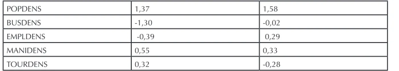
Table 2. Stimulus coordinates
POPDENS 1,37 1,58
BUSDENS -1,30 -0,02
EMPLDENS -0,39 0,29
MANIDENS 0,55 0,33
377
PROCEEDINGS OF THE 51st SIDEA CONFERENCE
FARM -0,84 -0,39 USTS -1,49 0,29 COMPUS -1,70 0,25 LAB 2,53 -0,20 USPC 0,79 -1,25 AVERAGE 0,15 -0,61 S-stress: 0,02768 (good) RSQ: 0,99348
Graph 1. Derived Stimulus Configuration. Euclidean distance model.
5. Results and Discussion
Our analysis has been capable of describing and interpreting the relation/integration of agricul-ture with other activities in the territory of the Marches, utilizing the LLSs. It must be noted that the LLSs are the statistical units and not as the observed issues, so that any consideration is to be related to the overall regional territory.
In table 2 and graph 1 we report the results of the MDS using the eleven descriptive variables. In the graph, the interpretations of bi-dimensional coordinates (orthogonal and perfectly uncor-related) are feasibly because the S-stress is near to zero, and the distortion is then tolerable. The first dimension is characterized by positive values of the intensity of family days of farm work (LAB) and the availability of cultivated area (net of permanent grassland) on inhabitants (USPC). In this dimension, also noteworthy is the definite coordinate of the population density (POPDENS). On the contrary, the major negative coordinates affect the density of firms on inhabitants (BUS-DENS), the density of farms with a formal entrepreneurial profile (FARM), the ratio between ‘net’ cultivated area on total agricultural area (USTS) and on the total cultivated area (COMPUS). Even considerable is the negative coordinate of the ratio of employees in for-profit enterprises on
resi-dents (EMPLDENS). We could name this dimension as ‘social resilience of agriculture’.
The second dimension is characterized by the high positive value of the coordinate of the popula-tion density (POPDENS), while, within the negative coordinates, the availability of cultivated area (net of permanent grassland) of inhabitants (USPC) and the average size of farms (AVERAGE), mea-sured by the cultivated area (net of permanent grassland). We argue this issue can reflect—from negative to positive values—a sort of ‘urban-rural continuum’, enabling us to underline that is the sole feature of the agrarian structure toward which the urban-rural ‘dialogue’ can exert some influ-ence. We could name this dimension as ‘social density and light industrialization’.
6. Conclusive considerations
The geometrical orthogonality of the two dimensions is––in our opinion––the most important result of the research. It shows in fact that, in the Marches, social resilience of agriculture is inde-pendent from industrial density and development. The agricultural resilience can/cannot occur due to strictly local causes, both in socio-economically scarce areas (high hills and mountains) and in heavily developed and most densely populated areas. In other words, while it is clear that the past characteristics of agriculture have favored the light industrialization, the rebound of industrialization on agricultural structures can be either positive or negative.
Overall results seemingly describe a persisting ‘double polarization’ of agriculture, capable of integrating within both the urban and rural socio-economic territorial systems. On the one hand, agriculture is capable of resisting well the forces of erosion resulting from the urban thickening. On the other hand, agriculture is capable of using any resources even in the more demographically dispersed areas, and contributing to maintain employment. That is to say the Marches’ agriculture seems to be vital regardless of the type of ‘incentive’ coming from the local socio-productive fabric and can conveniently self-adapt to different geo-socioeconomic environments. The rural and agricultural background has fostered the light industrialization over time, and conversely today the light industrialization ‘can or cannot’ combine with the agricultural resilience, considering the orthogonality of the two dimensions resulting from MDS.
In a territorial dimension, with a typical pull-effect, increasing urban densification would be ca-pable of restricting the physical base of the primary sector, even inducing an average farm size reduction, but not causing the weakening of farmers’ capabilities, which can organize farming in different local conditions. In the Marches agriculture found an original way of active coexis-tence with other industries both in dense and sparse populated areas, all of them characterized by the presence of industrial districts.
Thus a traditional approach of analysis, which usually associates ‘agriculture’ and ‘rurality’ will be not the best choice, because we actually can describe an agriculture which is capable to move along the lines both of a “weak compatibility” and a “strong compatibility” with the rest of industrial activities.
Positive results encourage us for further researches on the same topic and the same method, even considering the opportunity of future attention regarding the region of Emilia-Romagna and Veneto.
References
Anselmi, S. (1990), Mezzadri e mezzadrie nell’Italia centrale, in P. Bevilacqua (a c.), Storia
dell’agricoltura italiana in età contemporanea, vol. II, Venezia, Marsilio, pp. 201-259.
Becattini G. (1999), L’industrializzazione leggera della Toscana Ricerca sul campo e confronto
379
PROCEEDINGS OF THE 51st SIDEA CONFERENCE
Becattini G. (2001), Distretti industriali, in Garzanti (a c.) Enciclopedia dell’Economia, pp. 407-408, Milano, Garzanti.
Bellandi M., Sforzi F. (2001), La molteplicità dei sentieri dello sviluppo locale, in AA.VV. Il
calei-doscopio dello sviluppo locale – Trasformazioni economiche nell’Italia contemporanea, pp.
41-63, Torino, Rosenberg & Sellier.
Calafati, A.G., Mazzoni, F., (2006), Sviluppo locale e sviluppo regionale: il caso delle Marche,
Rivista di Economia e Statistica del Territorio n. 1, pp. 7-39.
Conti, G., (1996), Metropolizzazione delle aree rurali: ambiti, ambiente e aspetti valutativi, Atti
26° Incontro Ce.S.E.T., Firenze, Fupress, pp. 95-116.
Corinto G.L. (2014), Littoralization and rural-urban divide in the Italian region of the Marches. In Recep Efe (ed.) Town, City and Urbanization in Globalizing World: A Theoretical and
Prac-tical Perspective, pp. 305-316, Sofia, Klimet Ohridski University.
Corinto, G.L., Musotti, F., (2012), Il turismo countryside delle Marche: caratteristiche territoriali e comunicazione on-line, Agricoltura Istituzioni Mercati, pp. 151-166.
Dunford, M., Greco, L., (2005), After the Three Italies: Wealth, Inequality and Industrial Change, Oxford (UK), Wiley-Blackwell.
Fondazione Censis, (2002), Rappresentare il Policentrismo, Rapporto finale, Roma, Censis. Fuà G. (1988), Small-scale Industry in Rural Areas: The Italian Experience, in K.J. Arrow (ed) The
Balance between Industry and Agriculture in Economic Development. Proceedings of the
Eight World Congress of the International Economic Association, Delhi, India, Vol. I, Basic Issues, pp. 259-279, NY, St. Martin’s Press.
ISTAT (2010), 6° Censimento dell’agricoltura, Roma. ISTAT-ASIA (2010), Archivio asia, Roma.
ISTAT (2011), Censimento generale della popolazione e delle abitazioni, Roma. Kruskal J. B., Wish M. (1978), Multidimensional Scaling, London, Sage Publications.
Musotti F. (2001), Le radici mezzadrili dell’industrializzazione leggera, in AA.VV. Il
caleidosco-pio dello sviluppo locale – Trasformazioni economiche nell’Italia contemporanea, pp.
93-116, Torino, Rosenberg & Sellier.
Orasi A., Sforzi (2005), I sistemi locali del lavoro. Censimento 2001. Dati definitivi, 21 luglio, http://www.istat.it
Regione Marche (2014), Sistema informativo statistico, http://statistica.regione.marche.it Tomaselli V. (1993), Analisi multidimensionale e inferenza sociologica, Milano, Franco Angeli.