S
PATIAL STRUCTURE AND ECONOMIC DEVELOPMENT
:
T
HE CASE OF
I
TALY
David Burgalassi
Tesi di Dottorato
Università di Pisa
Dipartimento di Economia e Management
Dottorato di Ricerca in Economia Politica
Settore Scientifico-Disciplinare
SECS P/06 –Economia Applicata
Direttore della Scuola di Dottorato Prof. Davide Fiaschi
Tutor
Prof. Tommaso Luzzati
S
PATIAL STRUCTURE AND ECONOMIC DEVELOPMENT
:
T
HE CASE OF
I
TALY
David Burgalassi
PhD Dissertation submitted to the Department of Economics and
Management
University of Pisa
in fulfilment of the requirements for the degree of
Doctor of Philosophy
in
Economics
Department of Economics and Management
University of Pisa
Abstract
The aim of this thesis is contributing to the debate about the organization of economic activities across space and its impacts both on economic competitiveness and on environmental sustainability.
The first chapter states the most important aspects of spatial structure, which are polycentric development and urban dispersion, and highlights the relevance of spatial economic organization for public policies, in particular with reference to the spatial policies addressed by the European Union. In order to assess the effects of spatial structure, the second chapter tackles the issue of the analytical definition and measurement of polycentricity and dispersion. By surveying the most relevant literature in urban and regional economics, and geography and spatial planning, the chapter illustrates the main analytical dimensions and the empirical methods for the measurement of spatial structure at regional level, providing an empirical illustration on Italian regions.
The third chapter analyses the relationships between spatial structure and economic competitiveness in Italian NUTS-3 regions. It presents the theoretical framework, grounded on agglomeration economies literature, and check whether agglomeration economies may depend on spatial organization of economic activities across Italian regions. In the empirical analysis labour productivity is taken as a proxy for economic competitiveness and both of polycentricity and urban dispersion seems to have negative impacts.
The fourth chapter analyses the links between spatial structure and environmental pressure. The latter have been measured by gas emissions generated by private road transport and house heating. After the literature review, the chapter shows, through regression analysis of NUTS-3 regions, that spatial structure influences CO2 emissions from transport and PM10 emissions from house heating, with no evidence that polycentricity helps in reducing emissions.
The thesis concludes discussing the main results from the empirical part of the work and sketch further steps in the analysis of spatial structure and economic development.
JEL classification
O18 - Urban, Rural, Regional, and Transportation Analysis
R11 - Regional Economic Activity: Growth, Development, Environmental Issues, and Changes R12 - Size and Spatial Distributions of Regional Economic Activity
R14 - Land Use Patterns O47 - Aggregate productivity Q53 - Air Pollution Keywords Spatial structure Agglomeration economies Urban regions Polycentricity Urban dispersion Regional development
Contents
PART 1
1 Introduction ... 7
1.1 Spatial distribution of economic activities and agglomeration economies ... 7
1.2 Evolution of urban systems, spatial structure and the scope of agglomeration economies . 9 1.3 Polycentric development: from a descriptive concept to a normative tool ... 11
1.4 Urban dispersion and urban and regional development ... 14
1.5 The spatial dimension of policies and the aspects of urban and regional development: economy, environment, society ... 15
1.6 The case of Italy and the units of analysis ... 18
1.7 Methodology and plan of the thesis ... 20
2 Defining and measuring spatial structure ... 23
2.1 Spatial structure and the role of centres ... 23
2.1.1 The role of centres ... 24
2.1.2 The role of spatial interaction and networks of centres ... 26
2.2 Polycentricity ... 27
2.2.1 Spatial scales involved in polycentricity... 27
2.2.2 Morphological and functional polycentricity ... 28
2.2.3 The measurement of morphological polycentricity ... 33
2.2.4 The measurement of functional polycentricity ... 37
2.3 Urban dispersion ... 45
2.3.1 Definitions of dispersion ... 46
2.3.2 The measurement of dispersion ... 48
2.4 Polycentricity and Dispersion: links and overlaps ... 49
2.5 APPENDIX: Polycentricity in Italian regions ... 51
2.5.1 The selection of indicators ... 51
2.5.2 Relationships between morphological and functional indicators... 52
2.5.3 Polycentricity and economic performances in the Italian regions ... 55
PART 2
3 Spatial Structure and Productivity in Italian NUTS-3 Regions ... 69
3.1 Introduction ... 69
3.2 The role of spatial structure for economic performances ... 70
3.3 The model ... 74
3.4 Data and variables ... 75
3.4.1 Quantifying spatial structures ... 75
3.4.2 Dependent and control variables ... 77
3.4.3 Empirical specification and results ... 82
3.5 Concluding Remarks... 87
3.6 APPENDIX: Spatial structure and economic performance in Italian Functional Urban Regions ... 89
3.6.1 Urban Dispersion and Polycentricity... 89
3.6.2 Model specification, methodology and data ... 91
3.6.3 Main results ... 95
3.6.4 Concluding remarks ... 98
4 Urban spatial structure and environmental emissions: a survey of the literature and some empirical evidence for Italian NUTS-3 regions ... 101
4.1 Aims ... 101
4.2 Spatial structure and the environment ... 103
4.2.1 Definitions of spatial structure ... 103
4.2.2 Spatial structure and environmental quality ... 106
4.3 Italian empirical evidence ... 109
4.4 An empirical analysis ... 114
4.4.1 Data sources ... 114
4.4.2 Main results ... 115
4.5 Conclusions ... 116
4.6 APPENDIX: Regression results ... 118
4.6.1 Transport emissions ... 118
4.6.2 House heating emissions ... 119
5 Conclusions ... 121
5.1 Main results ... 121
5.2 Discussion and further steps ... 123
List of tables
Table 1: Urbanised land in Italy ... 19
Table 2: Rank-size estimates for Italian regions, 2001 ... 52
Table 3: Selected indicators of polycentricity, Descriptive statistics. ... 52
Table 4: Correlation coefficients between indicators of polycentricity ... 53
Table 5: Levels of morphological and functional polycentricity in Italian regions ... 55
Table 6: variables used in the analysis ... 58
Table 7: Pearson correlation coefficients between the degree of NUTS-2 polycentricity and ESDP’s key dimensions of performance ... 59
Table 8: regression results for the analysis of the role of polycentricity on key performance (t-statistics in italic) ... 59
Table 9: List of variables with description, source of data and basic statistics ... 81
Table 10: First stage results of the two-stage least-squares (Model 2) regressions on per worker labour productivity ... 83
Table 11: Estimation results. Dependent variable: lab_productivity. Robust standard errors are reported in brackets. ... 84
Table 12: Estimation results. Dependent variable: lab_productivity. Estimations for regions of different size classes. Robust standard errors are reported in brackets. ... 87
Table 13: Pearson correlation coefficients among indicators of spatial structure ... 91
Table 14: Descriptive statistics for the variables used in the analysis ... 94
Table 15: Estimation results. Job and population growth 1991-2001 ... 96
Table 16: Estimation results with interactions. Jobs and pop. growth 1991-2001 ... 97
Table 17: The contribution of road transport to total emissions (%) ... 111
Table 18: Evolution of mileage by type of vehicle (109 vehicles-km/y) ... 111
Table 19: Control variables and statistical sources ... 115
Table 20: The role of spatial structure for transport emissions, summary of results ... 116
Table 22: CO2 cars: per capita emissions ... 118
Table 23: PM10 cars: absolute emissions ... 118
Table 25: CO2 house heating: absolute emissions ... 119
Table 26: CO2 house heating: per capita emissions ... 119
Table 27: PM10 house heating: absolute emissions ... 120
Table 28: PM10 house heating: per capita emissions ... 120
List of figures
Figure 1: The Randstad, the archetypal polycentric urban region ... 12
Figure 2: Triangle of Objectives: a Balanced and Sustainable Spatial Development ... 16
Figure 3: Christaller regional hierarchy of centres ... 25
Figure 4: Spacing of cities ... 30
Figure 5: Size-distribution ... 31
Figure 6: Relational dimension ... 32
Figure 7: Rank size log linear estimations ... 35
Figure 8: effects of threshold in a non linear rank-size relationship ... 36
Figure 8: Entropy Index ... 41
Figure 9: Dominance index ... 43
Figure 10: Node-symmetry index ... 44
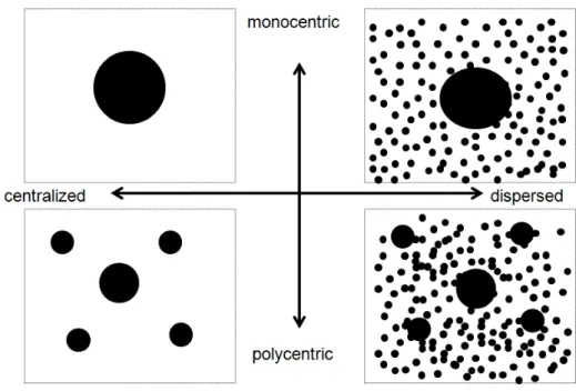
Figure 11: Centralized and dispersed regions ... 45
Figure 12: polycentricity and dispersion ... 50
Figure 13: Rank-size estimator and primacy index ... 54
Figure 14: Rank-size estimator and Ordinary Polycentricity ... 54
Figure 15: Gini index of income distribution and Ordinary polycentricity ... 61
Figure 16: Discontinuous urban fabric and Ordinary Polycentricity ... 63
Figure 17: The spatial structure of Italian NUTS-3 regions: a simple taxonomy ... 78
Figure 18: Polycentricity and per worker productivity levels (logs) in Italian NUTS-3 regions, 2001 ... 79
Figure 19: Centralization of the spatial structure and per worker productivity levels (logs) in Italian NUTS-3 regions, 2001 ... 80
Figure 20: Regional size (total population) and per worker productivity levels (logs) in Italian NUTS-3 regions, 2001 ... 80
Figure 21: the Italian Functional Urban Regions ... 92
Figure 22 Centralized and dispersed regions ... 104
Figure 23: Links between spatial structure and emissions ... 109
Figure 24: CO2 in Italy from 1980 to 2012. ... 110
Figure 25: PM10 in Italy from 1990 to 2012. ... 111
Figure 26: CO2 emissions from transport, private vs. goods and public transport ... 112
Figure 27: Evolution of passengers*km in a working day ... 112
Figure 28: The evolution of modal choices in Italy: the index numbers of the average number of travels in a working day, 2001-2011 ... 113
1 Introduction
This thesis aims to analyse the relationships between spatial structure and urban/regional economic development, with a special focus on the empirical evidence that can be drawn for Italy. The work is based on urban and regional economic analysis, in particular on agglomeration economies, a phenomenon which has been recognised as one of the most important drivers for development of cities and regions. In particular, the thesis investigates whether agglomeration advantages may be linked to the spatial organization of economic activities across Italian urban regions. The work focuses on two major aspects of spatial structure, polycentricity and urban dispersion, which show increasing interest both in the academic literature and territorial policies, and require more empirical analysis. This introductory chapter sets the theoretical framework, provides the research questions and presents polycentricity and urban dispersion, describing their (supposed) role for urban and regional development. This chapter and the entire thesis give particular attention to polycentricity, since it has become a key tool addressing spatial policies of European States.
1.1 Spatial distribution of economic activities and agglomeration
economies
In 2005 T. L. Friedman wrote that “world is flat” (Friedman, 2005), telling about the “death of distance”. Accordingly, many aspects of globalisation – such as technological and organizational changes – caused increasing irrelevance of geography and distance for economic agents. Hence, in a world fully connected proximity is any more important. However, those propositions are far from being verified. Economic activity appears to be increasingly concentrated. In his popular reply to Friedman’s work, R. Florida (2005, 48) wrote that “World is spiky” giving some facts illustrating that “surprisingly few regions truly matter in today’s global economy” and that “the tallest peaks – the cities and regions that drive the world economy – are growing even higher, while the valleys mostly languish”. Hence,
population and economic activities are far from being evenly distributed across space. On the contrary, economic production has become increasingly concentrated, especially at smaller spatial scales, such as within Countries (World Bank, 2009). The more innovative activities are even more concentrated, while industrial mature sectors have been moved mainly towards developing economies. Income levels, growth rates and distribution show significant spatial heterogeneity. This holds also in Europe: many stylized facts confirm that European Countries are characterised by strong heterogeneity in economic concentration and specialization of their regions (Combes and Overman, 2004). Additionally, patterns of convergence have substantially differed between and within Countries, which have often showed patterns of polarization. Italy confirms the evidence that economic activity is characterised by patterns of geographical concentration in many economic sectors (de Dominicis et al., 2013).
Hence, even in a globalised world, distance and proximity do matter for economic development, and economic activities are “much more clustered that would be expected if location was the result of a random outcome” (Puga, 2010, p. 203). Actually, the main clusters of economic activities are represented by cities, which are the engines of economic growth for regions and Countries. Compared to other areas, cities present some advantages for firms and workers, which have been recognised in early economics works, such as in Smith (1776) and especially in the Principles of Economics book by Marshall (1890), and then stimulated a huge amount of research during the last Century. The interest in agglomeration advantages as drivers for urban and regional endogenous growth increased especially in the last two decades years, with the advent of ‘New growth theories’ (Lucas, 1988) and the ‘New Economic Geography’ (Krugman, 1991, 1995; Fujita et al. 1999). Economic research approached the advantage in cities mainly by showing that (Puga, 2010):
1. The spatial distribution of economic activity is highly clustered;
2. Wages and land rents differentiate across space, cities show higher values, which should reflect some advantages;
3. Productivity is higher in cities.
The drivers of the advantages of cities and urban environments are represented by agglomeration economies, which, starting from Mashall (1890) have been subject of increasing amount of theoretical and empirical research, especially in the last decades. Agglomeration economies can be defined as positive externalities, i.e. advantages for the economic agents that are usually based on their geographic or relational proximity (Duranton and Puga, 2004). When taking into account the production processes, agglomeration economies can refer to single firms (scale economies), to the clustering of firms within the same industry (localisation economies), or to the proximity of economic agents from different sectors (urbanisation
economies).1
The literature that has approached localisation economies states that proximity of same industries enhances innovation processes and growth through mechanisms of cooperation – Marshall-Arrow-Romer externalities (Combes, 2000) – or competition – Porter externalities (Porter, 1990)– among economic agents.2 According to urbanisation economies theories, proximity is maximised in cities, where density and size of economic activities are high and foster mechanisms of ‘sharing’ of information and ideas, ‘matching’ of job supply and demand and ‘learning’ processes by the workforce (Duranton and Puga, 2004). Urbanization externalities appear to be relevant for innovative activities and hi-tech sectors (de Groot et al., 2009).
1.2 Evolution of urban systems, spatial structure and the scope of
agglomeration economies
Notwithstanding the differences between the main theoretical and empirical approaches to agglomeration economies, size and density have been assumed as the main proxy of agglomeration. In particular, urbanisation economies have been assumed to be an increasing function of scale and density – up to a certain threshold – and a decreasing function of the distance from the urban cores (Rosenthal and Strange, 2004). Agglomeration economies within industries (static localisation and dynamic MAR externalities), which may regard small and medium sized firms, do require an aggregate critical mass to exploit.
However, urban regions have been subject to huge changes in their structure in the last decades. Cities expanded their geographical scope and (especially in Europe) new functional urban regions – or cities de facto – arose as result of territorial coalescence of pre-existing self-contained cities (Calafati and Veneri, 2013). These phenomena yield to patterns in the spatial structures of urban areas that are definitely more complex than the simple physical expansion of cities and they might influence economic activities and relationships occurring within and between cities. Two main aspects that have been identified are urban dispersion and polycentricity (Anas et al., 1998).
One of the most evident features of contemporary urban region is represented by
1
Another distinction can be made between static and dynamic externalities. The former affect the level of economic activity, and can be related to scale of production (scale economies), industrial advantages (localisation externalities) or aggregate demand and variety (urbanisation externalities). The latter affect knowledge spillover – hence innovation and growth.
2For a discussion of the sources of agglomeration economies, see Glaeser et al. (1992). For a meta-analysis, see de Groot et al. (2009). For an application to Italy see Cirilli and Veneri (2011).
suburbanisation and related urban dispersion, or urban sprawl. The massive structural changes caused by the Industrial Revolution, with both the demographic and urban transition, led to the physical expansion of cities, which increased their role as engines for regional economic growth (Hohenberg and Lees, 1985). Technological improvements in urban and interurban transport driven urban expansion
In the early 20th century P. Geddes analysed the changes in the urban forms – as cities evolved into urban areas and eventually into conurbations (Geddes, 1915). During the 20th Century urban dispersion interested most of the urban areas, affecting American cities firstly and then European ones driven by several factors, including growth in incomes, technological progress in transport systems, change of preferences, demographic change and migration (Anas et al, 1998).
A second feature that characterise contemporary urban region is polycentricity that is the presence of several economic centres within urban areas and regions, which can be characterised by interaction and mutual interdependencies. In some cases polycentricity has been driven by patterns of re-clustering of activities. If in the past the Central Business District (CBD) was a major focal point of the urban economy (Alonso, 1964; Muth, 1969; Mills, 1972), in the recent decades economic activities have re-clustered in new sub-centres within the same urban region. In other cases polycentric urban regions have been the results of pre-existing centres that become more interconnected. This pattern has been found mainly in European urban systems, which may show high land constraints and the poor availability of open space. In Europe, cities are traditionally linked to each other, with high relational densities and a physical proximity (Calafati, 2009). Thus, physical growth in cities has appeared more in the form of the coalescence of existing centres rather than the emergence of new cities, while in other cases, such as in American regions, new centres are likely to be built.
Given the above-mentioned dynamics, for more than thirty years, spatial structures and economic performance have been recognized as being strictly linked to each other (Parr, 1979; 1987). A thesis that has been proposed is that the dynamics of change in urban regional systems have been linked with a ‘regionalisation’ of agglomeration economies (Meijers and Burger, 2010). Regional development can be fostered by localised network externalities, (Boix and Trullén, 2007), which for instance be generated by the networking between “major agglomerations and their hinterland” and by “dense networks of big or middle sized cities” (Barca, 2009, p. 18). Those externalities can substitute simple agglomeration externalities and allowing for the emergence of regionalised urbanisation economies (Meijers and Burger, 2010). In other words, cities may “borrow” each other’s size in order to achieve the critical mass needed to generate agglomeration economies (Alonso, 1973).
However, while there is a consolidated research on the role of size and density for economic activity (Ciccone and Hall, 1996; Rosenthal and Strange, 2004), little attention has been devoted to the “spatial configuration of cities and regions and the geographical scale of agglomeration benefits” (Burger et al., 2010, p. 20). In particular, few studies have been
investigated the effects on agglomeration economies of other aspects of spatial structure than size and density, such as polycentricity and urban dispersion. The gap between research on agglomeration economies and studies on spatial structure, noticed by Parr in 1979, still exists. This is particularly true when considering the inter-urban spatial level, i.e. the urban region.
However, even if there is no adequate academic endorsement to the role of spatial structure on economic development, the above mentioned ideas represent a theoretical rationale at the basis of current European and National territorial strategies (Commission of the European Union, 2011), especially those promoting polycentric development. This thesis aims to bridge this gap, at least partially, by focusing on polycentricity and urban dispersion. With reference to those two aspects, writers have provided explanations on their role for economic development but, to date, the empirical analysis is quite poor and, when there is, quite equivocal.
1.3 Polycentric development: from a descriptive concept to a normative
tool
The above-mentioned ideas of ‘regionalisation of agglomeration economies’ and ‘borrowed size’ represent now a theoretical rationale at the basis of current European and National strategies promoting polycentric development, especially in the European context.
The notions of polycentricity and polycentric development have been traditionally applied at the intra-urban level, which is the study of cities. In land planning, polycentriciy began to be studied as a characteristic of cities in alternative of the monocentric model, while at the inter-urban spatial scale, which is the spatial level addressed by this thesis, the literature focused on the concept of “Polycentric Urban Region” (PUR) (Parr, 2004), and some European regions characterised by pronounced polycentricity were identified.
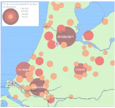
The archetypal example of a PUR is the Randstad Region, in the Netherlands, represents the archetypal PUR (Figure 1). It is a region composed by four main cities (Amsterdam, Rotterdam, The Hague, and Utrecht) of comparable size, characterised by economic complementarity and highly interconnected. Amsterdam represents a major hub for finance, air transport, and tourism. The Hague concentrates Government and administrative functions. Rotterdam’s economy is rooted in his port. Utrecht is specialised in services and cultural sector.
Figure 1: The Randstad, the archetypal polycentric urban region
Source: http://en.wikipedia.org/wiki/Randstad
Another example of the PUR is the Rhine
of the largest world conurbation composed by eight cities
the largest city, has around 590 000 inhabitants, while Oberhausen, the smallest centre, has 210 000 inhabitants) (Cox, 2013)
Diamond’ in Belgium (an area composed by the cities of Brussels, Antwerp, Ghent and (Albrechts, 2001) and the Venice
Salone, 1993).
However, since the European Spatial Development Perspective (ESDP) was published in 1999, the concept of polycentric development ceased to be only analytical and began to assume a normative relevance as a strategic concept to promote both economic, social and sustainability goals (Davoudi, 2003).
Committee on Spatial Development of the European and
for Spatial Planning in the Member States of the European Union, with the aim t balanced and sustainable development of the European Union.
of around a decade of gestation (
represented by the “development of a balanced and polycentric urban relationship” (European Commission
Polycentricity would promote not only regional growth, thought the regionalisation of agglomeration economies, but also cohesion and sustainability. Polycentric development represents a tool for spatial policies, within the general framework of EU policies, such as those established by the Lisbon Strategy (
Spatial policies should foster polycentricity not only within urban areas, but across the
: The Randstad, the archetypal polycentric urban region
Source: http://en.wikipedia.org/wiki/Randstad
Another example of the PUR is the Rhine-Ruhr region in Western Germany, which is one of the largest world conurbation composed by eight cities of similar size (Dusseldorf, which is the largest city, has around 590 000 inhabitants, while Oberhausen, the smallest centre, has (Cox, 2013). Other well-known examples of PURs include the ‘Flemish (an area composed by the cities of Brussels, Antwerp, Ghent and
(Albrechts, 2001) and the Venice-Treviso-Padua region in North-East Italy
since the European Spatial Development Perspective (ESDP) was published in 1999, the concept of polycentric development ceased to be only analytical and began to assume a normative relevance as a strategic concept to promote both economic, social and
tainability goals (Davoudi, 2003). The ESDP is the territorial strategy
Committee on Spatial Development of the European and agreed by the Ministers responsible for Spatial Planning in the Member States of the European Union, with the aim t
balanced and sustainable development of the European Union. Agreed in 1999, it is the result gestation (Schmitt, 2011). Accordingly, one of the main pillars is represented by the “development of a balanced and polycentric urban system and a new rural
European Commission, 1999).
Polycentricity would promote not only regional growth, thought the regionalisation of agglomeration economies, but also cohesion and sustainability. Polycentric development esents a tool for spatial policies, within the general framework of EU policies, such as those established by the Lisbon Strategy (2000), the action plan for the EU.
Spatial policies should foster polycentricity not only within urban areas, but across the in Western Germany, which is one of similar size (Dusseldorf, which is the largest city, has around 590 000 inhabitants, while Oberhausen, the smallest centre, has examples of PURs include the ‘Flemish (an area composed by the cities of Brussels, Antwerp, Ghent and Leuven Italy (Camagni and since the European Spatial Development Perspective (ESDP) was published in 1999, the concept of polycentric development ceased to be only analytical and began to assume a normative relevance as a strategic concept to promote both economic, social and The ESDP is the territorial strategy prepared by the agreed by the Ministers responsible for Spatial Planning in the Member States of the European Union, with the aim to achieve a d in 1999, it is the result Accordingly, one of the main pillars is urban system and a new rural-Polycentricity would promote not only regional growth, thought the regionalisation of agglomeration economies, but also cohesion and sustainability. Polycentric development esents a tool for spatial policies, within the general framework of EU policies, such as Spatial policies should foster polycentricity not only within urban areas, but across the
whole territory of the EU. The improvement of regional accessibility and the diffusion of information and knowledge represent some pre-condition for polycentric development.
The ESDP has been followed by other policy statements and has stimulated subsequent research on polycentric spatial structures and social, economic and environmental performances. In 2007 the ‘Territorial Agenda’ came out. The document was strongly rooted on ESDP, and stressed the goal of territorial cohesion, following the general framework stated by the Fourth Report on Economic and Social Cohesion that was launched immediately before (European Commission, 2007). Accordingly, polycentric development is a tool for “making better use of available resources in European regions”:
“We stress that polycentric and balanced territorial development of the EU is key element of achieving territorial cohesion. Where the most developed cities and regions within Europe cooperate as parts of a polycentric pattern they add value and act as centres contributing to the development of their wider regions. Urban development policies also have a significant role in this regard. Polycentric territorial development policy should foster the territorial competitiveness of the EU territory also outside the core ‘Pentagon area’. We encourage cities to form networks in an innovative manner, which may allow them to improve their performance in European and global competition and promote economic prosperity towards sustainable development.
At the same time we aim at polycentric development at the macro‐regional, cross‐border and also on national and regional level in relevant cases. Where possible, it is important to avoid polarization between capitals, metropolitan areas and medium sized towns on the national scale. Small and medium‐sized towns can play a crucial role at regional level. Policy efforts should contribute to reducing the strong territorial polarisation of economic performance, avoiding large regional disparities in the European territory by addressing bottlenecks to growth in line with Europe 2020 Strategy.”
The Territorial agenda was then updated with the ‘Territorial Agenda of the European Union 2020’, agreed between the ministers for spatial planning and territorial development of EU Member States in 2011 (European Commission, 2011). The document has been released in order to adapt spatial policy to the new Economic and Social Agenda of the European Union 2020, the so called ‘Europe 2020 strategy’ and again stressed the role of polycentric development.
However, despite the general success of polycentrism in the policy agenda, polycentricity is still a fuzzy and vague concept and its effectiveness still needs to be corroborated with appropriate empirical research (Davoudi, 2003; Meijers, 2008). So far, policies aiming at polycentric development may thus lack a strong scientific rationale, and polycentric development appears to be one of the “code words” of Europe (Clark, 2001): “a coded term but not rigidly codified, ambiguous, with changeable outlines” (Baudelle, 2007).
1.4 Urban dispersion and urban and regional development
Urban dispersion is the second relevant dimension of spatial structure that is addressed in the thesis. The concept of dispersion refers to the extent to which economic activities are spatially concentrated in centres or, conversely, evenly dispersed. Hypothetically, we have two polar cases depending on where most of human activity is settled, either concentrated in one (or more) centre or diffused homogeneously across the region. Recent dynamics in rich countries has often moved regional structure towards dispersion rather than concentration, generating the so-called “urban sprawl”.
The increase in urban dispersion became relevant in North America already in the first half of 20th century due to the revolution involved by mass motorization (Burchfield et al, 1998). Commuting became cheaper and easier allowing more freedom in the choice of the residential location. People did not anymore need to live close to their workplace or commercial activities and started to relocate out from city cores. Residential relocation firstly involved upper income classes, who initially could afford the use of private vehicles, then, due to the decline in transport costs, also low income households attracted by the cheaper land prices of the surroundings (Le Roy and Sonstelie, 1983). The cheap land prices also made the new settlements to be characterized by extensive land use. Similar dynamics appeared later on in Europe and other areas, where urban growth came together with urban sprawl in the last decades, in particular in the most advanced regions and in areas characterized by rapid economic growth (European Environment Agency, 2006).
Given those dynamics, urban dispersion received increasing attention from economist, planners, and policy makers. Actually, the perception about urban sprawl is mainly negative. Many studies stressed the adverse effects of this pattern of development on the environment (Camagni et al., 2002a, 2002b), given the loss of fertile soil, the increase in traffic due to longer distances and higher use of motorised private transport, the higher energy requirements of ‘extensive’ patterns of urban development. Opponents of sprawl suggest also that dispersion may cause other adverse economic effects. Dispersion can be related to spatial mismatch between firms and workers (Wheeler, 2001). Additionally, dispersion may weaken agglomeration externalities that characterise dense cities. In dispersed areas chances for informal communication and face-to-face contact are lower, thus reducing possibilities for the exchange of innovative ideas, which are at the basis of the dynamic externalities pointed out by endogenous growth theories. As a result, dispersed cities may be characterised by lower aggregate productivity, than concentrated and dense cities. Other effects of urban dispersion may be related to social cohesion: dispersed area have sometimes been linked to urban segregation (Nechyba and Walsh, 2004) and spatial mismatch.
However, there is no agreement on the effects of urban dispersion. Some authors state that urban sprawl is a phenomenon naturally related to urban growth (Gordon and Richardson, 1997). Moreover, dispersed cities can offer many advantages to people and firms,
such as low house prices and larger housing lots, less traffic congestion than dense areas (Gordon and Richardson; Glaeser and Kahn, 2004). According to this view, the negative effects of dispersion on agglomeration economies are far from being verified.
The two opposed views on urban dispersion turn into opposite policy ideas. While opponents of sprawl call for more regulation and strict planning rules aimed to promote compact city policies, such as the movement of ‘smart growth’, the advocates of sprawl propose a free-market approach.
As for polycentric development, it seems that more research is required to assess the effects of urban dispersion, starting from its definition and measurement, since there is no agreement in that (Galster et al., 2001).
1.5 The spatial dimension of policies and the aspects of urban and
regional development: economy, environment, society
As pointed out in section 1.1, the last decades were characterised by strong development of economic theories, especially those related to growth and development, which started to include geographic aspects into their analytical models and empirical tools, according to them
place matters for national development. However, despite those developments in theoretical
and applied analysis, the field of policy implementation had not made significant progress (Barca et al. 2012). While territorial features have been acknowledged to play a key role, development policies have been quite ‘place-neutral’. It is often the case that local and regional policies have been characterised by ‘isomorphism’3, when similar or identical strategies have been formulated by different regions, even if highly differentiated in their cultural, social and economic context (Chien, 2008). As highlighted by Barca et al. (2012, p. 137), regional policies had been based on sectoral dimension, with top-down decision making. Frequently, strategies imitated successful policies that had been implemented in different regions, with different contexts.
However, in recent years policy has been addressed towards spatial aspects. In the last decades some reports by international organizations including the World Bank (2009) and the OECD (2009a, 2009b) stressed the role of space in economic systems and subsequently the need to re-think economic policies by including the spatial dimension. Meantime, European strategic policies started to towards a ‘place-based’ approach for regional development policies. This approach to policy is based on the links between economic local context and
3
The phenomenon of ‘isomorphism’ has been firstly observed by organizational studies, with reference to the tendency for organizations to exhibit similar behaviour, despite their differentiations (Di Maggio and Powell, 1991)
institutions (Barca, 2009; Barca et al., 2012).
The inclusion of the spatial aspects in regional strategies of the European Union considers a multi-dimensional approach to development. This approach characterises the whole Union since 1986 (Single European Act), when European Union policies have been aimed to improve economic and social cohesion. Later, Amsterdam Treaty (1997) stated that economic and social progress of EU should take into account the principle of sustainable development and within the context of the accomplishment of the internal market and of reinforced cohesion and environmental protection, making clear the multidimensional nature of development. In order to reach EU policy goals, it was clear that spatial economic organization of cities and regions could represent a tool to promote both growth and cohesion, as well as sustainable development. This was the idea underlining the ESDP, which came out in 1999.
The spatial strategies agreed starting from the ESDP, adopt a multi-dimensional approach to urban and regional development. The ESDP has intended spatial policy ideas, such as polycentricity, as tools to achieve a sustainable spatial development. The idea of sustainability of spatial development relates to three main dimensions: economy, society and environment. The Territorial Agenda (2007) reinforced the need for appropriate territorial actions to promote the more general sustainable development
Figure 2: Triangle of Objectives: a Balanced and Sustainable Spatial Development
(Source: ESDP, 1999, p. 10)
However, after Amsterdam Treaty and the ESDP, still Union sectoral policies had no a clearly defined spatial goals. Lisbon Treaty (2009) and subsequent ‘Europe 2020’ Strategy for the period 2010-2010 (which replaced the ‘Lisbon Strategy’) introduced territorial cohesion a policy goal, together with economic and social cohesion. According to Europe 2020 Strategy,
Europe should aim to smart, sustainable and inclusive growth. This goal should be reached by more effective investment in education and research (smart), the switch to a low-carbon economy (sustainable) and with emphasis on employment creation and reduction of poverty (inclusive). The strategy focused on goals to be reached by 2020, with reference to employment (75% of population aged 20-64 should be employed), innovation (3& of European GDP should be invested in research and development), climate and energy (gas emissions should reduce by 20% compared to 1990 levels, the share of renewable energy should be 20% of the total energy sources, energy efficiency should increase by 20%), education (the share of early school leavers should be under 10% and at least 40% of young population should have a tertiary degree), poverty reduction (20 million less people should be at risk to be poor).
The ‘Territorial Agenda Europe 2020’ (2011) reflects the goals of the Europe 2020 Strategy, stating the territorial priorities for the EU:
1. polycentric and balanced territorial development;
2. integrated development in cities, rural and specific regions;
3. territorial integration in cross-border and transnational functional regions; 4. competitiveness of the regions based on strong local economies;
5. territorial connectivity as pre-condition for cohesion;
6. managing and connecting ecological, landscape and cultural values of regions. Europe 2020 Strategy and the TA 2020 are linked to each other, and show the increasing priority given to the exploitation of territorial strengths in order to enhance the sustainable and inclusive development of the whole Union. This includes how to deal with agglomeration and cities, since urban areas increase productivity and innovation, but also show negative effects, such as pollution and social segregation. The place-based approach is explicitly mentioned by the TA 2020 in order to reach territorial cohesion.
To sum up, as addressed by EU strategies, policies have increasingly spatial dimensions, whose effects should be analysed in the multi-dimensional light of the Europe 2020 strategy: competitiveness, sustainability and cohesion. This thesis adopts a multi-dimensional approach, by looking at competitiveness and sustainability of regions, investigating how spatial structure could affects those dimensions. For time and data constraints territorial cohesion has not explicitly taken into account. However, the conclusions of the work will give some insights on the relevance of the topic and directions for further research.
1.6 The case of Italy and the units of analysis
When investigating the links between spatial structure and development, Italy represents one of the most interesting case studies in Europe. Italian regions and local areas have been a playground for regional and urban economists and geographer for a long time, for many reasons. Italian regions show high heterogeneity in their economic contexts. The most well-known phenomenon is probably the economic divide between North and South, which became evident after the reunification of the Country in 1861. The question of ‘Mezzogiorno’ has been addressed by many policies starting from the second half of 20th century, aimed to industrialization and development of southern regions, but the gap with Northern regions still exists (La Spina, 2003).
Another phenomenon that characterised Italian economic development is the rise of the ‘Third Italy’, that is the set of regions of Central and North-Eastern Italy, driven by cluster of small and medium-size enterprises which, despite their size, succeeded in the international competition. This form of development stimulated a huge amount of literature about local development and the role of industrial districts for regional growth (Becattini, 1979; Sforzi, 1990). In addition to regional heterogeneity, Italy is also characterised by pronounced variety within regions (Calafati, 2009): hence, local factors appear to be at least as much important as regional factors in the analysis of development.
The third relevant phenomenon is the noticeable urban development that characterised Italy. Italy has historically shown high degrees of urbanization (Malanima, 2005). However, the industrial take-off after the Second World War was coupled with huge urbanization process – so that according to some authors the country showed a ‘territorial revolution’ (Calafati and Veneri, 2011). Urban areas developed by means of city growth and territorial coalescence, which changed dramatically the spatial organization of economic activity. Nowadays cities and urban areas are increasingly integrated in terms of functions and mutual interactions: this is evident for instance in daily commuting flows.
Within this context, the aspects of spatial structure are increasing their relevance. Polycentricity, which is a feature that characterise some of the Italian regions, especially in central and north eastern Italy, has also entered in some regional policies, such as of Tuscany in Central Italy (Tuscany Region, 2005).
At the same time, urban dispersion is causing increasing concerns. As noticed by Camagni et al. (2002b), Italian urban areas have been characterised in the last decades by a phenomenon of scattered urbanization, while during the 1950s and the 1960s urban expansion had been characterised by relatively compact interventions. The phenomenon interested not only large cities, but also small and medium towns. Figures about Italy illustrate that urbanised land in Italy grew dramatically in the last decades. During the Fifties, urbanised land occupied 2.9% of Italian surface. In 1996 the value was doubled. In 2012, urbanised land occupied 7.3% of total Italian land. This trend has been particularly evident in the last 20 years,
when urbanised land increased by around 1/3. Land use patterns have been characterised by extensive land use, since the per capita urbanised surface grew by 30% (Table 1).
Table 1: Urbanised land in Italy
Fifties 1989 1996 1998 2006 2009 2012
Urbanised land (%) 2.9 5.4 5.9 6.1 6.8 7.0 7.3
Urbanised land (km2) 8 700 16 220 17 750 18 260 20 350 21 170 21 890
Per capita urbanised surface (m2/pop) 178 286 312 321 350 359 369
Source: ISPRA, 2014
The empirical part of the thesis (Chapters 3 and 4) takes into account Italian NUTS-3 regions (province) as elementary units of analysis in assessing the role of spatial structure respectively for economic competitiveness and environmental sustainability. Provinces are administrative units that are intermediate between the NUTS-2 level represented by regions (regioni) and the NUTS-4 level of municipalities (comuni).
The literature has pointed out how crucial is the choice of the units of analysis for the outcome of applied regional analysis. Hence, a change of spatial units might lead to a change in analytical results: this is the well know Modifiable Areal Unit Problem (MAUP). This problem can be related either to the aggregation of smaller units into larger areas or to the definition of areal boundaries (Openshaw and Taylor, 1979; Burger et al., 2010). Even if no general solutions have been found to solve the MAUP, the general advice is to take into account functional areas as units of analysis. In Italy this could be possible, by selecting functional data, such as the Local Labour Systems, which are local areas defined by commuting flows, or Functional Urban Regions. However, those spatial levels also present some drawbacks, such as the poor data availability (especially with reference to economic data) and impracticality of international comparison. Hence, the studies on European regions and urban areas often use either NUTS-2 or NUTS-3 level.
Provinces (NUTS-3) are administrative units. Notwithstanding the MAUP, there are several reasons for choosing NUTS-3 regions as units of analysis. First, provinces are the intermediate level between municipalities and larger regions. Agglomeration economies may be relevant at several spatial scales. However, municipalities appear to be a too small level, given also the dynamics of territorial coalescence, according to which most of the urban areas are composed by more than one municipality. At the same time, regions (NUTS-2 level) may be too large for the exploitation of agglomeration benefits, also considering that Italian NUTS-2 regions are considerably larger than other European NUTS-2 level4. Hence, the provincial intermediate level appears to be the most suitable (administrative) level to minimise MAUP.
Secondly, given the high degree of urbanization in Italy, core cities tend to be
4
With average population of 2.83 million inhabitants, Italian Regions are the largest NUTS-2 level regions in Europe (excluding Latvia, which has only one NUT-2 region) (Source: Eurostat).
determined and path dependent. Provinces exist, with relatively minor changes, since the second half of 19th Century, and were based to the largest existing cities. So it appears reasonable that this spatial level has a still a strong role in the spatial organization of urban areas.
Thirdly, provinces have relevant policy powers, especially in the field of territorial planning – a level which is intermediate between the regional level (that set up the general framework for land planning) and municipal level. Hence, focusing on this spatial scale makes a perfect congruence between the object of analysis and the subject of policy. This then enables there to be a more direct and easy transposition of the results in terms of possible policy recommendations.
Fourthly, the political and administrative powers of Italian NUTS-3 regions are provided for metropolitan areas5. The metropolitan area is the most investigated scale in the literature in terms of the regionalization of agglomeration economies.
Finally, data availability, for instance in productivity measurements (such as carried out in Chapter 3), means that the best unit of analysis is the NUTS-3 regions (Fiaschi et al., 2011). NUTS-3 regions have also been taken into account by many reports dealing on spatial development, including those carried out by the European Spatial Planning Observation Network (ESPON6), the Programme created by European Union to support territorial policy.
However, the concept of spatial structure is scalar, hence it can be applied to several territorial levels. Hence, the thesis provide an appendix to Chapter 2 that analyses NUTS-2 level polycentricity, since this is the most relevant spatial level to achieve the goals addressed by EU policies, such as ESDP and territorial agenda. While, after Chapter 3, an appendix consider whether the hypothesis of regionalization of agglomeration externalities holds for Functional Urban Regions (FURs) – assessing the role of polycentricity and urban dispersion for employment growth.
1.7 Methodology and plan of the thesis
In order to answer to its main question, whether spatial structure can have a role for urban and regional development, the facts that have been sketched in this chapter show that there is no adequate empirical assessment. Spatial structure characteristics have gained quite a lot of success in territorial policies, as seen in the case of polycentricity – which has been turned in
5 In 1990 Italian law introduced the possibility of setting metropolitan areas as units of analysis, which would take
the same power as NUTS-3 regions. At the moment, no metropolitan area has yet been set.
6
‘polycentricism’. However, many of the policy propositions may lack adequate analytical endorsement and empirical assessment. Some research points out the hypothesis of ‘regionalization’ of agglomeration economies and ‘borrowed size’, while other works have investigated the role of urban dispersion and sprawl. However, few works have been devoted to an integrated analysis of spatial structure.
A key problem, which hampered research on the economic effects of spatial structure, is represented by the complex and multidimensional nature of the concept, which conveys many aspects, definitions and measure. In order to answer to the main research question, this thesis investigates the issue of the analytical definitions and measurements of spatial structure at the regional level. This is the topic of Chapter 2, which concentrates on two major aspects of spatial structure: polycentricity and dispersion. As highlighted in this introductory chapter, polycentric development and urban dispersion are subject to increasing interest. However, those aspects lack common and shared definitions and measures. This is especially true for polycentric development, which “remains a rather fuzzy concept as it seems to mean different things to different actors and on different scales” (Meijers, 2008, p. 1313). The chapter addresses the issue of the definition of polycentric development by reviewing the literature concerning the topics and identifying the main analytical dimensions involved, which are the morphological and the functional dimension. Then, it summarises and discusses the main measures that have been proposed by the literature. Compared to polycentricity, urban dispersion appears to have a more consolidated background about its definition and measurement. However it is a multi-faceted phenomenon as well. Hence, the chapter lists the main aspects of dispersion and possible measures. Some examples have been given to explain and discuss the measures used to measure polycentricity and dispersion.
An appendix of Chapter 2 applies some of the indicators proposed to the analysis of Italian NUTS-3 Regions, with particular reference to polycentricity. It shows the relationships between the morphological and functional dimensions and gives taxonomy accordingly. Then, it discusses the links between polycentricity and the policy goals stated by the ESDP and subsequent documents (as seen in sections 1.3 and 1.5): economic competitiveness, territorial cohesion and environmental sustainability.
Chapter 2 is preparatory to the subsequent to the empirical part of the thesis, which is presented by chapters 3-4. Both assess the role of spatial structure of Italian NUTS-3 Regions (province). Chapter 3 analyses the role of spatial structure for territorial competitiveness of provinces. Following the most relevant literature on the field, competitiveness is conceptualised in terms of labour productivity. The chapter firstly states the rationale for the analysis and reviews the most relevant literature. Then it shows the results of the empirical work, which is based on regression analysis. Some methodological and empirical issues are also discussed.
An appendix to chapter 3 has been added in order to show the effects of spatial structure on economic development, in order to show that other spatial scales than provinces
can be taken into account – it considers Italian Functional Urban Regions (FURs) as units of analysis – and to set a dynamic framework to assess economic competitiveness – which has been conceptualised in terms of population and employment growth.
Chapter 4 addresses the relationships between spatial structure and environmental
pressure. Namely, it studies gas emissions from private road transport and house heating emissions. By surveying the most relevant literature it summarises the possible links between spatial structure and emissions. The survey provides the framework to explore the empirical evidence for Italian provinces concerning CO2 and PMs emissions. A set of equations has been
estimated by regression analysis, which considered separately transport and housing sectors.
Chapter 5 concludes, recalling the main results from the thesis, which allow for a critical
discussion about the role of spatial structure, in particular polycentricity, on urban and regional development. It also discusses the drawbacks of the analysis and the lines of future research on the topic.
2 Defining and measuring spatial
structure
Outline
Regional spatial structure has many dimensions, which involve several definitions and measures. This chapter tackles the problem of defining and measuring spatial structure under an integrated and multi-dimensional perspective. I adopt a taxonomy that distinguishes between two main aspects of spatial structure: polycentricity and dispersion. For each aspect, the issue of definition and measurement is discussed.
2.1 Spatial structure and the role of centres
Spatial structure is a multi-dimensional and complex phenomenon, which has been approached by several disciplines, such as geography, land planning, ecology, urban and regional economics.
According to Horton and Reynolds, the concept of spatial structure refers to “an abstract or generalized description of the distribution of phenomena in geographic space” (1971, p. 36). From an economic point of view, those phenomena refer to the economic activities of firms and households - namely residential and productive (or trade) activities - across space. The city is the environment in which those activities develop and influence each other. The main elements of spatial structures are “nodes” (e.g. plants, residences,…), linear features (e.g. transport networks) and surfaces (Horton and Reynolds, 1977, p. 36).
As highlighted in the literature (for instance by Lee, 2006, 9) urban spatial structure is the resultant of the distribution of people and economic activity across space, which is in turn the outcome of long-term processes involving locational preferences of agents and public policies. The distribution of economic activities, which is sometimes called “urban form”
(Anderson et al., 1996), is related to urban interactions: urban form and interactions together give rise to spatial structure (Bourne, 1982).
The centres are the key elements in the regional structure and development. Being characterized by concentration of economic activity, the centres represent the economic core of spatial systems, providing functions to the rest of the region. Urbanization has promoted agglomeration economies (Glaeser et al. 1992) and cities represent the engines of economic growth for regions and countries. By means of several mechanisms, urban environments promote economic advantages for firms and households, which may turn in higher productivity, income and quality of life (Glaeser, 2011).
Actually, the dynamics of human settlements, both in history and space, can usefully be described by referring to the changing roles of the centres and of the territory around them. In some instances regions are organised around a main centre, in other we observed several interconnected centres, while the urbanization degree and patterns around centres may considerably differ (Camagni et al., 2002). Despite we acknowledge the multi-faceted nature of the concept of spatial structure, this works focuses on urban dispersion and polycentricity (Meijers and Burger, 2010), two concepts that, despite their interrelationships (Gordon and Wong, 1985, 662), need to be kept distinct. In both cases, however, the centre is the fundamental concept that is used to define spatial structure.
2.1.1 The role of centres
The notion of centre represents the key notion of both aspects of
monocentricity/polycentricity and centralization/dispersion.
Centres represent areas characterised a certain level of agglomeration and density of economic activity, which provide functions for a spatial scope that exceeds their areas. When the spatial area to be considered is a region, centres can be conceptualised by cities. If the spatial area taken into account is a city, the centre has been conceptualised by its Central Business District (CBD) that is the main economic core of the city.
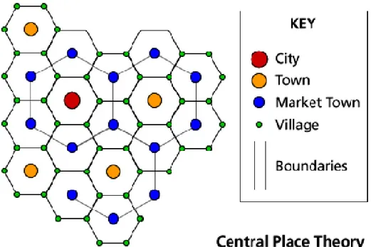
The notion of centres as basic concepts to define hierarchies within regions was firstly introduced in geography by the seminal contribution of the German geographer Walter Christaller (1893-1969). In this famous contribution (1933) Christaller developed a theory to explain how economic activities7 do organise over space, generating urban hierarchies. Accordingly, central places maximise the matching between supply and demand of services. Services provided by centres do differ in terms of their thresholds, which are the minimum marked needed for a certain service or good to be sold (e.g. to benefit from agglomeration economies), and ranges, which are the maximum distance that consumers are willing to travel to buy goods and services. Differences in thresholds and ranges describe hierarchies of
7
functions: high quality services are characterised by higher threshold and ranges, hence are concentrated (Jacobs, 1969). The highest function defines market areas. Then, lower functions locate where the highest functions are already localised. Since lower functions have lower ranges, their marker areas are smaller than higher functions: this causes that some areas of the regions are not covered by the function. This allows for the existence of sub-centres, which provide functions, except for the highest.
As result, settlements within a region are characterised by a hierarchy: the main centre, which is the regional capital, hosts all possible functions (in terms of provision of services and goods), other centres are characterised by the supply of lower level functions and ranked according to the number of function they host: cities, towns, market towns, villages. Three kinds of forces determine the spatial organization of the regional economy: the market principle (i.e. the minimization of centres providing the highest function), the transport principle (i.e. the minimization of transport costs for the provision of high level functions), and the administrative principle (i.e. the allocation of lower centres to only one upper centre). Those principles determine factors of proportionality with reference to the number of sub-centres. According to the market principles, there are 3 lower-order centres for each higher level area. According to the transport principle, there are 4 lower-order centres for each higher level area. According to the administrative principle, there are 7 lower-order centres for each higher level area.
Figure 3: Christaller regional hierarchy of centres
The approach of Christaller was then reprised and developed by August Lösch (1906-1945). In 1940 he developed a model that criticised some of the rigidities of Christaller’s theory, such as the fixed factors of proportionality. Lösch model also allows for centre specialization: a high level centre may not host lower order functions: centres of comparable size may differ in terms of functional specialization (Camagni, 1992).
However, both approaches conclude that regions are organized according to hierarchies, and those hierarchies are defined by the functions provided by centres. Economic factors, such as transport costs, competition between firms, consumer rationality, minimization of administrative costs, drive the spatial organization of regions, in terms of number of centres, their functions and their localization (in terms of distances between centres). Christaller and Lösch contributions, which represent spatial equilibrium models, stimulated a branch of literature aimed to assess regional spatial organization (Beckmann and Pherson, 1970; Beguin, 1984; Parr, 1985; Mulligan, 1984; Nijkamp, 1986).
2.1.2 The role of spatial interaction and networks of centres
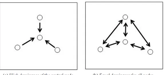
The system of linkages between centres, and between centres and their surroundings, represent the second key concept in the definition of spatial structure. It has been shown how those relationships are increasingly important in urban development. In fact, in many cases urban growth patterns have been in contrast with the predictions made by Central Place Theory (Camagni, 1993). Sometimes centres have shown urban specialization (hence contrasting Christaller theoretical predictions). In other cases large centres do not show the presence of all functions, while smaller centres host high-rank functions. Centres can be linked to other centres specialised in similar functions (e.g. financial services, ICT) and located beyond the region, while within the region synergies among similar centres may happen (e.g. industrial districts) (Capello, 2007).
Networks are involved in many of the above-mentioned facts. Hence, a theory of city networks developed in order to interpret structure and evolution of urban systems. Accordingly, relations between centres can be not only hierarchical, but also horizontal, that is between cities of comparable rank8. As result, networks of complementarity or networks of synergy can characterise urban regions. Complementarity networks are characterised by economic specialization of each centre, while synergy networks consist in linkages between similar centres that are likely to cooperate. In the latter case, centres benefit from network externalities (Camagni and Salone, 1993). A particular case of synergy networks is represented by the innovation networks, where centres cooperate in order to reach the scale economies needed to carry on innovative activities (e.g. infrastructures) (Capello, 2007).
8
“City networks consist of sets of horizontal, not hierarchical, relationships among complementary or similar centres. These relationships generate economies or externalities of, respectively, specialization/division of labour and of synergy/cooperation/innovation” (Capello, 2007, 80).