Legal Notice
Neither the Publisher nor any persons acting on behalf of the Publisher is responsible for the use which may be made of the following information.
Abstracts published in this volume were evaluated and the opinion of the Scientific Committee concerning the originality and scientific value, decides about including an abstract into the volume. However, neither the Reviewers, nor the Editors and the Publisher assume the responsibility for errors, linguistic or numerical, which is fully responsibility of Authors. The Authors were responsible for referring to appropriate and complete references and for obtaining the necessary permission to reproduce copyright materials and data from other sources.
Copyright on any article in this Volume of Conference Proceedings is retained by the Authors under the Creative Commons license 4.0 (Attribution-Noncommercial-Share Alike 4.0 Unported), which permits to copy, redistribute remix, transform, and build upon the material in any non-commercial medium or format, provided the original work is properly cited.
Title
Flowpath 2019, National Meeting on Hydrogeology Conference Proceedings Editors Luca Alberti Tullia Bonomi Marco Masetti Technical Editing Tullia Bonomi Marco Faggioli Stefania Stevenazzi Publisher 2019 Ledizioni LediPublishing
Via Alamanni, 11 - 20141 Milano, Italy www.ledizioni.it
ISBN: 978-88-5526-012-1 doi: 10.14672/55260121
Organizing Committee
Chairs: Luca Alberti, Tullia Bonomi, Marco Masetti
IAH - Italian Chapter Members: Daniela Ducci, Sergio Rusi, Paolo Cerutti, Paolo Fabbri, Alessandro Gargini, Francesco La Vigna, Marco Petitta, Vincenzo Piscopo, Maurizio Polemio, Viviana Re, Andrea Sottani, Daniela Valigi
Local Organizing Committee
Corrado Camera, Ivana La Licata, Gabriele Oberto, Marco Rotiroti, Alberto Gennaro Stefania, Stefania Stevenazzi
Scientific Committee
Giovanni Pietro Beretta, Fulvio Celico, Alfonso Corniello, Stefania Da Pelo, Marina De Maio, Lucio Di Matteo, Maria Dolores Fidelibus, Francesco Fiorillo, Paolo Frattini, Giorgio Ghiglieri, Beatrice Giambastiani, Paola Gigli, Manuela Lasagna, Elena Leale, Stefano Lo Russo, Francesca Lotti, Micol Mastrocicco, Roberto Mazza, Vittorio Paolucci, Giorgio Pilla, Elisabetta Preziosi, Rudy Rossetto, Giuseppe Sappa, Michele Saroli, Laura Scesi, Marco Tallini, Alberto Tazioli, Luca Zini
Preface
FLOWPATH 2019, the 4th National Meeting on Hydrogeology, was held in Milan from 12th to 14th June 2019. According to the aim of the previous Editions of FLOWPATH, held in Bologna (2012), Viterbo (2014) and Cagliari (2017), the conference is an opportunity for Italian hydrogeologists to exchange ideas and knowledge on different groundwater issues.
The objectives of the conference are:
- To promote dialogue and exchange of scientific knowledge among young hydrogeologists; - To deepen the theoretical and practical aspects of our understanding on groundwater; - To update all the stakeholders, researchers and professionals on recent challenges in the
hydrogeological sciences;
- To encourage researchers, professionals and administrators to contribute to the improvement of water resources management.
This Volume of Conference Proceedings contains the abstracts of oral and poster contributions accepted to FLOWPATH 2019. The abstract were evaluated by the Scientific and Organizing Committees. This volume contains 99 abstracts, submitted by Authors coming from Universities, Public Authorities and Private Companies of Italy and many other countries, such as Australia, Belgium, Croatia, Czech Republic, Greece, Hungary, Israel, Malta, Morocco, Nigeria, Spain, Switzerland, The Netherlands, U.K., and U.S.A.
The conference focuses on four themes of great importance: 1. Groundwater Resource Management
2. Fractured Rocks and Karst Aquifers 3. Contaminated Sites
4. Urban Hydrogeology
The content of the Conference Proceedings is organized according to the four topics of the conference. The keynote lectures open the sessions were they were presented, followed by the scientific contributions in alphabetical order by first author’s family name.
Editors: Luca Alberti Tullia Bonomi Marco Masetti
I
NDEX
GROUNDWATER RESOURCE MANAGEMENT ... 1 THE MANAGEMENT OF GROUNDWATER RESOURCES IN THE MALTESE ISLANDS ... 2
Manuel Sapiano
ESTIMATING THE EFFECT OF THE DESERT-ADAPT MEASURES ON POREWATER AVAILABILITY FOR TEN AGRICULTURAL SITES IN EUROPE ... 3
Luigi Alessandrino, Eleonora Grilli, Simona Castaldi, Micòl Mastrocicco
HYDROGEOLOGICAL CHARACTERISATION OF THE FLUMENDOSA PLAIN ... 6
Claudio Arras, Roberto Balia, Paolo Botti, Cristina Buttau, Pierluigi Cau, Stefania Da Pelo, Antonio Funedda, Giorgio Ghiglieri, Alfredo Loi, Mario Lorrai, Maria Teresa Melis, Maurizio Testa
GEOLOGICAL CRITERIA TO THE 3D DELIMITATION OF GROUNDWATER BODIES (GWB) IN THE HYDROGRAPHIC DISTRICT OF SARDINIA ... 9
Claudio Arras, Roberto Balia, Paolo Botti, Cristina Buttau, Pierluigi Cau, Stefania Da Pelo, Antonio Funedda, Giorgio Ghiglieri, Alfredo Loi, Mario Lorrai, Maria Teresa Melis, Maurizio Testa
THE ROLE OF THE NORCIA PLAIN AQUIFER IN THE GROUNDWATER FLOW OF THE SIBILLINI MTS. HYDROSTRUCTURE: A PRELIMINARY NUMERICAL MODEL BASED ON THE EFFECTS OF 2016 SEISMIC SEQUENCE ... 12
Francesca Banzato, Alessandro Lacchini, Lucia Mastrorillo, Stefania Passaretti, Chiara Sbarbati, Daniela Valigi, Sara Veroli, Marco Petitta
INFERRING DIFFERENT HYDROGEOCHEMICAL PROCESSES IN A COASTAL AQUIFER VIA FACTOR ANALYSIS ... 15
Gianluigi Busico, Nerantzis Kazakis, Emilio Cuoco, Nicolò Colombani, Dario Tedesco, Micòl Mastrocicco
THE ENERAG PROJECT: TOWARDS A DYNAMIC SYSTEM APPROACH FOR GEOFLUIDS ... 18
Corrado Camera, Daniele Pedretti, Ferenc Mòlnar, Teppo Arola, Timea Havril, Anita Erõss, Marco Masetti, Juha Kaija, Judit Mádl-Szőnyi
DEPTH PROFILES OF H2O,C,N AND S STABLE ISOTOPES IN A SHALLOW AQUIFER-AQUITARD BELOW AGRICULTURAL FIELDS REVEAL LARGE HYDROCHEMICAL HETEROGENEITIES IN CONTRASTING SOILS ... 20
Nicolò Colombani, Ramon Aravena, Giuseppe Castaldelli, Micòl Mastrocicco
HYDROGEOCHEMISTRY AND NATURAL BACKGROUND LEVELS FOR THE GROUNDWATER BODY OF SELE RIVER PLAIN (SOUTHERN ITALY) ... 23
Alfonso Corniello, Daniela Ducci, Mariangela Sellerino, Del Gaudio Elena
EVALUATING CONJUNCTIVE USE OF GROUND- AND SURFACE-WATER AND CROP YIELD IN RURAL ENVIRONMENTS BY MEANS OF SIMULATION TOOLS ... 25
Giovanna De Filippis, Federico Triana, Matteo Ghetta, Iacopo Borsi, Wolfgang Schmid, Rudy Rossetto
PROMOTING WATER RESOURCE MANAGEMENT THROUGH THE USE OF ICT TOOLS AND PARTICIPATORY APPROACH .... 27
Giovanna De Filippis, Iacopo Borsi, Laura Foglia, Massimiliano Cannata, Rotman Criollo, Enric Vázquez-Suné, Irena Kopač, Björn Panteleit, Pio Positano, Marco Saulo Nannucci, Manuel Sapiano, Daria Svidzinska,
Mykhailo Grodzynskyi, Rudy Rossetto
THE VISTAPROJECT: A TEST SITE TO INVESTIGATE THE IMPACT OF TRADITIONAL AND PRECISION IRRIGATION ON GROUNDWATER (SAN GEMINI BASIN,CENTRAL ITALY) ... 30
USE OF PIEZOMETRIC TIME SERIES FOR THE IDENTIFICATION OF GROUNDWATER HYDRODYNAMIC BEHAVIOURS AND CONTROLLING FACTORS: THE CASE STUDY OF THE PIEDMONT PLAIN (ITALY)... 33
Manuela Lasagna, Susanna Mancini, Domenico Antonio De Luca
IMPACT OF ENVIRONMENTAL, HYDRAULIC AND CONSTRUCTION PARAMETERS ON NITRATE REMOVAL RATE AND NITROUS OXIDE RELEASE OF DENITRIFICATION WALLS IN A SUBTROPICAL CLIMATE ... 36
Fabio Manca, Daniele De Rosa, Lucy Reading, David Rowlings, Clemens Scheer, Peter Grace
METHODS FOR THE ANALYSIS OF PIEZOMETRIC LEVEL EVOLUTION IN TIME AS RESPONSE OF CLIMATE CHANGE:
CURRENT TRENDS AND RESOURCE STATUS IN PIEDMONT PLAIN (NWITALY) ... 39
Susanna Mancini, Manuela Lasagna, Domenico Antonio De Luca
STOCHASTIC ANALYSIS OF HYDRAULIC HEAD'S SERIES FOR OPTIMIZING MONITORING NETWORKS: APPLICATION TO THE BACCHIGLIONE BASIN ... 42
Mara Meggiorin, Giulia Passadore, Silvia Bertoldo, Andrea Sottani, Andrea Rinaldo
STOCHASTIC ANALYSIS OF TEMPERATURES' TIME SERIES FOR CHARACTERIZING A FLUVIAL WORK EFFICIENCY ON A REGIONAL MANAGED AQUIFER RECHARGE PILOT SITE... 45
Mara Meggiorin, Giulia Passadore, Silvia Bertoldo, Andrea Sottani, Andrea Rinaldo
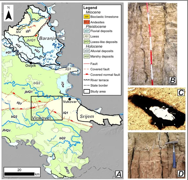
HYDROGEOLOGICAL CONCEPTUAL MODEL OF LOESS DEPOSITS: A CASE STUDY FROM EASTERN CROATIA ... 48
Marco Pola, Ivica Pavičić, Staša Borović, Teuta Vranješ, Lidija Galović, Lara Wacha, Vedran Rubinić, Kosta Urumović
MULTI-TECHNIQUE GROUNDWATER FLOW SYSTEM ANALYSIS AND DATING OF A DEEP AQUIFER IN ALESSANDRIA BASIN (PIEDMONT) ... 51
Nicola Quaranta, Elena Cogo, Adriano Simoni, Elisa Sacchi, Mariachiara Caschetto,Massimo Marchesi
HYDROLOGICAL BEHAVIOUR OF A COMPLEX LANDSLIDE: A CASE STUDY IN THE NORTHERN APENNINES (ITALY) ... 53
Melinda Raimondo, Alessandro Chelli, Fulvio Celico, Emma Petrella
GROUNDWATER MODELLING IN SUPPORT OF WATER RESOURCES PUBLIC MANAGEMENT WITHIN THE METROPOLITAN AREA OF MILAN ... 55
Chiara Righetti, Desdemona Oliva, Maurizio Gorla, Luca Alberti, Agata Angela Cristaldi
MANAGED AQUIFER RECHARGE AS A SOLUTION TO COPE WITH WATER SCARCITY: THE LIFEREWATSUVERETO INFILTRATION BASIN ... 58
Rudy Rossetto, Giovanna De Filippis, Simone Maria Piacentini, Marta Lazzaroni, Simone Neri, Davide
Continanza, Mirko Brilli, Patrizio Lainà, Marco Masi, Alessandra Pei, Valentina Menonna, Federico Lazzaroni, Alessandro Fabbrizzi
WATER MANAGEMENT IN LIMPOPO NATIONAL PARK AREA ... 61
Giuseppe Sappa, Maurizio Barbieri, Stefania Vitale
GROUNDWATER AND SURFACE WATER QUALITY CHARACTERIZATION WITH POSITIVE MATRIX FACTORIZATION ... 64
Chiara Zanotti, Tullia Bonomi, Letizia Fumagalli, Marco Rotiroti, Gennaro Alberto Stefania, Sara Taviani, Marco Faggioli, Valentina Soler, Martina Patelli, Veronica Nava, Davide Sartirana, Giulia Stefenelli, Francesco Canonaco, Andre S.H. Prévôt, Barbara Leoni
FRACTURED ROCKS AND KARSTIC SYSTEMS ... 67 METHODOLOGICAL APPROACH FOR INVESTIGATION IN KARST HYDROGEOLOGY ... 68
Andreo-Navarro Bartolomè
HYDROGEOCHEMICAL MONITORING OF NATURAL WATERS FROM CENTRAL APENNINES,ITALY: MULTIPARAMETRIC ACQUISITION AND PROCESSING TO IDENTIFY POSSIBLE SEISMIC PRECURSORS ... 69
Marino Domenico Barberio, Francesca Banzato, Alessandro Lacchini, Valentina Marinelli, Marco Petitta, Chiara Sbarbati
MULTIDISCIPLINARY GEOPHYSICAL SURVEYS FOR 3D HYDROGEOLOGICAL CONCEPTUAL MODEL RECONSTRUCTION IN AREAS CONTAMINATED BY FLUORIDE IN NAKURU AREA,EAST AFRICAN RIFT SYSTEM (KENYA) ... 71
Stefano Bernardinetti, Chiara Gargiulo, Alessio Barbagli, Andrea Zirulia, Tommaso Colonna, Enrico Guastaldi, Paolo Conti, Lisa Serri, Stefano Bonfigli, Claudio Zanghirati, Luigi Antolini, Elias K. Ucakuwun, Stefania Da Pelo, Roberto Balia, Marco Pistis, Giorgio Ghiglieri
STATISTICAL ANALYSIS OF THE IMPACT OF SNOW MELTING AND RAINFALL RECHARGE ON THE DISCHARGE AND
PHYSICO-CHEMICAL CHARACTERISTICS OF THE VERDE SPRING (CENTRAL APENNINES) ... 74
Alessandro Chiaudani, Diego Di Curzio, Sergio Rusi
NOSSANA KARST SPRING BEHAVIOUR UNDER FUTURE CLIMATE CHANGE SCENARIOS ... 76
Andrea Citrini, Corrado Camera, Giovanni Pietro Beretta, Jacopo Terrenghi
NEW HYDROLOGICAL AND ISOTOPIC SURVEYS ON THE POIANO KARST SYSTEM ... 78
Vincenzo Critelli, Manuela Deiana, Vladislav Ivanov, Massimo Ercolani, Alessandra Curotti, Mario Mussi, Alessandro Corsini, Stefano Lugli, Monica Papini, Laura Longoni, Francesco Ronchetti
A SIMPLE GRAPHICAL METHOD TO VISUALIZE THE END-MEMBER FRACTIONS IN A THREE-COMPONENT GROUNDWATER MIXING: THE EXAMPLE OF FERRARELLE SYSTEM (RIARDO, SOUTHERN ITALY) ... 81
Emilio Cuoco, Stefano Viaroli, Vittorio Paolucci, Lucia Mastrorillo, Roberto Mazza, Dario Tedesco
RESULTS OF A RESEARCH REGARDING SPRINGS WHICH FOLLOW THE HYPERBOLIC RECESSION FUNCTION WITH N <1 ... 84
Walter Dragoni, Simone Maria Piacentini, Vincenzo Piscopo
LONG-TERM HYDROGEOLOGICAL IMPACTS OF THE "FIRENZUOLA" HIGH-SPEED RAILWAY TUNNEL (NORTHERN
APENNINES) ... 86
Maria Filippini, Piero Civollani, Giovanni Mazzei, Enrico Dinelli, Alessandro Gargini
THE UPWELLING GROUNDWATER FLOW IN THE KARST AREA OF GRASSANO-TELESE SPRINGS (SOUTHERN ITALY) ... 88
Francesco Fiorillo, Guido Leone, Mauro Pagnozzi, Vittorio Catani, Giovanni Testa, Libera Esposito
RESPONSE OF THE MAIN SPRINGS OF THE SIBILLINI MOUNTAINS AREA TO THE 2016-2017 SEISMIC SEQUENCE ... 90
Davide Fronzi, Francesca Banzato, Costanza Cambi, Roberto Checcucci, Lucia Mastrorillo, Francesco Mirabella, Torquato Nanni, Marco Petitta, Alberto Tazioli, Daniela Valigi
PROCESS-BASED RESOURCE VULNERABILITY ASSESSMENT ON THE EXAMPLE OF GÖMÖR-TORNA KARST,HUNGARY AND SLOVAKIA ... 93
Veronika Iván, Judit Mádl-Szőnyi
THE IMPACT OF GEOMORPHOLOGIC STRUCTURE ON RAIN WATER INFILTRATION AND GROUNDWATER RECHARGE IN SEMI-ARID ZONE ... 95
Or Letz, Roey Egozi, Ofer Dahan
SPRING DISCHARGE MONITORING NETWORK IN A HIGH-ALPINE SETTING: AN EXAMPLE FROM THE PALE DI SAN
MARTINO (DOLOMITES MOUNTAINS,ITALY) ... 98
Giorgia Lucianetti, Roberto Mazza, Lucia Mastrorillo, Piergiovanni Partel
THE PILATO LAKE (SIBILLINI MTS.,CENTRAL ITALY): FIRST RESULTS OF A STUDY ON THE SUPPOSED VARIATIONS OF ITS HYDROGEOLOGICAL CONDITIONS INDUCED BY THE SEISMIC SEQUENCE 2016-2017 ... 101
Lucio Martarelli, Rossella Maria Gafà, Paolo Maria Guarino,Gennaro Maria Monti, Luca Maria Puzzilli, Angelantonio Silvi
HYDROGEOLOGICAL MODELS OF POTENTIAL SITES FOR A DEEP GEOLOGICAL REPOSITORY IN THE CZECH REPUBLIC AS PART OF THE SITE SELECTION PROCESS ... 104
Marek Vencl, Ondrej Mikláš
CAN GEOENTROPY BE USED TO PREDICT TRANSPORT IN FRACTURED MEDIA?RESULTS FROM PRELIMINARY TESTS.... 107
Daniele Pedretti, Marco Bianchi
GROUNDWATER FLOW IN THE ISCHIA VOLCANO AND IMPLICATIONS OF THERMAL WATER WITHDRAWALS ... 109
Vincenzo Piscopo, Francesca Lotti, Luigi Lana
GREY-BOX DATA DRIVEN BASED METHOD FOR KARST SPRING DISCHARGE EVALUATION... 111
Giuseppe Sappa, Francesco Maria De Filippi, Silvia Iacurto, Gerardo Grelle
DISCHARGE MEASUREMENTS BASED ON TRACER DILUTION METHOD APPLIED TO THE HYDROGEOLOGICAL STUDY OF KARST SPRINGS IN THE MOUNT ALBO AREA (SARDINIA NE) ... 114
Antonio Maria Sessini, Francesco Sanna, Giorgio Ghiglieri
A DETAILED GEOLOGICAL RECONSTRUCTION AS A TOOL FOR THE RELIABLE NUMERICAL MODEL IMPLEMENTATION: THE EUGANEAN GEOTHERMAL SYSTEM CASE STUDY (NEITALY) ... 117
Filippo Torresan, Leonardo Piccinini, Paolo Fabbri, Marco Pola, Mauro Cacace, Dario Zampieri
KARST CONNECTIVITY IDENTIFICATION: COMBINING A LONG-LASTING CROSS-HOLE HYDRAULIC TEST AND THE
STOCHASTIC INVERSION FOR LARGE-SCALE AQUIFER CHARACTERIZATION ... 120
Michela Trabucchi, Daniel Fernàndez-Garcia, Jesús Carrera, Xavier Sanchez-Vila, Alvaro Hernandez, Corrado Torre
HYDROLOGIC BALANCE ESTIMATION IN THE MUCILLE (NEITALY) TEST SITE ... 122
Philippe Turpaud, Luca Zini, Chiara Calligaris
THE LATERAL GROUNDWATER EXCHANGES FROM MT.MAGGIORE AQUIFER AND RIARDO PLAIN HYDROGEOLOGICAL SYSTEM ... 124
Stefano Viaroli, Emilio Cuoco, Lucia Mastrorillo, Vittorio Paolucci, Dario Tedesco, Roberto Mazza
IDENTIFICATION AND CHARACTERIZATION OF THE KARST AREAS OF THE FRIULI VENEZIA GIULIA REGION (NEITALY) ... 127
Luca Zini, Chiara Calligaris,Furio Finocchiaro, Paolo Manca, Chiara Piano, Michele Potleca, Maurizio Ponton, Luca Terribili
CONTAMINATED SITES ... 129 MODELLING CONTAMINANT TRANSPORT IN GEOLOGICAL MEDIA: CHALLENGES AND PERSPECTIVES ... 130
Marco Bianchi
METHODOLOGICAL APPROACH FOR THE ASSESSMENT OF GROUNDWATER CONTAMINATION BY TRANSITION METALS LEACHED THROUGH WASTE ROCK DUMPS: THE C.NA PECORARA MUCK DUMP SITE CASE STUDY (HV/HC“TERZO VALICO” PROJECT) ... 131
Alessandro Baietto, Paolo Perello, Alberto Scuderi, Luigi Marini
ASSESSMENT OF SOIL BUFFER CAPACITY ON NUTRIENTS AND EMERGING CONTAMINANTS AT TWO BLUE
INFRASTRUCTURES FOR THE PROVISION OF WATER-RELATED AGROECOSYSTEM SERVICES ... 133
Alessio Barbagli, Benjamin Niklas Jensen, Muhammad Raza, Christoph Schüth, Rudy Rossetto
ANAEROBIC AND AEROBIC BIOREMEDIATION OF CHLORINATED SOLVENTS AND HYDROCARBONS PLUMES FROM AN OLD LANDFILL IN THE VENICE LAGOON ENVIRONMENT ... 135
Giovanni Pietro Beretta, Lucia Cavalca, Martina Bertolini, Sarah Zecchin, Giovanni Buscone, Laura Ledda, Laura Ferrari, Giacinto Carnevale, Gerardo Bozzetto, Jacopo Terrenghi
IN SITU CONTAINMENT OF PFAS IN GROUNDWATER USING COLLOIDAL ACTIVATED CARBON ... 138
TRA-KD: AN IMPROVED TOOL FOR PARTICLE TRACKING SIMULATION BASED ON THE KOLMOGOROV-DMITRIEV THEORY ... 140
Alessandro Comunian, Gianluca Cannizzaro, Francesca Giacobbo, Mauro Giudici
THE ‘POLLUTER PAYS PRINCIPLE’: A MULTIDISCIPLINARY APPROACH UNDER LEGAL AND TECHNICAL PERSPECTIVES ... 142
Dario Covucci
A METHODOLOGICAL APPROACH FOR THE IDENTIFICATION OF SULPHATE SOURCES IN THE PORTOSCUSO AREA (SOUTH -WESTERN SARDINIA) ... 145
Stefania Da Pelo, Chiara Porru,Riccardo Biddau, Rosa Cidu, Carla Ardau, Cristina Buttau, Franco Frau, Maria Filippini, Gianfranco Mulas
GROUNDWATER REMEDIATION TECHNOLOGIES ON PETROLEUM HYDROCARBONS CONTAMINATED SITES IN ITALY: A MULTI-DISCIPLINARY STATISTICAL ANALYSIS... 148
Mara Dal Santo, Giuseppe Alberto Prosperi
CHEMICAL REAGENTS APPLICATIONS AS INNOVATIVE REMEDIATION TECHNOLOGIES FOR PETROLEUM HYDROCARBON IMPACTED GROUNDWATER IN ITALY ... 150
Mara Dal Santo, Giuseppe Alberto Prosperi
A THREE-DIMENSIONAL MULTICOMPONENT REACTIVE TRANSPORT MODEL TO ASSESS THE ROLE OF SUBSURFACE HETEROGENEITY ON ARSENIC MOBILITY IN THE SHALLOW AQUIFER OF THE VENETIAN ALLUVIAL PLAIN ... 152
Nico Dalla Libera, Paolo Fabbri, Daniele Pedretti, Leonardo Mason, Leonardo Piccinini, Fabio Tateo
MULTIPHASE FLOW AND SOLUTE TRANSPORT MODELLING OF A HYPOTHETICAL METHANE LEAKAGE INTO A SHALLOW AQUIFER ... 155
Andrea D’Aniello, Massimiliano Fabbricino, Daniela Ducci, Domenico Pianese
THE LANDFILL LEACHATE IMPACT ON GROUNDWATER HYDROGEOCHEMISTRY IN FINE DEPOSITS: A MULTIDISCIPLINARY STUDY ... 158
Diego Di Curzio, Sergio Rusi
EVALUATION OF THE PERFORMANCE OF A HYDRAULIC BARRIER BY A MONTE CARLO METHOD ... 161
Giovanni Formentin, Mariangela Vitiello, Alberto Francioli, Jacopo Terrenghi
3D CASE-STUDIES OF VOC CONTAMINATED SITES IN THE CITY OF THE HAGUE,THE NETHERLANDS... 164
Willem Havermans, Michiel Pluim
EVALUATION OF THE LARGE-SCALE PERMEABILITY OF THE SUBSTRATE OF A PHYSICALLY CONTAINED AREA AND DEVELOPMENT OF A SYSTEM FOR THE DYNAMIC MANAGEMENT OF HYDRAULIC GRADIENTS TO NEUTRALIZE
CONTAMINANT DIFFUSIVE FLUX ... 167
Elena Leale, Christine Ballarin,Emanuele Candiani,Andrea Moroni, Giovanni Russo, Mario Manassero, Sara Puma
FULL-SCALE APPLICATION OF EHC®LIQUID TECHNOLOGY FOR THE ISCR AND ERD TREATMENT OF AN AQUIFER CONTAMINATED WITH TETRACHLOROMETHANE AND CHLOROFORM... 170
Alberto Leombruni, Patrizia Trefiletti, Mauro Consonni, Linda Collina, Matteo Avogadri, Aldo Trezzi, Caterina Di Carlo
TESTING PHYTOSCREENING IN A SHALLOW AQUIFER CONTAMINATED BY CHLORINATED ETHENES ... 172
Carlotta Leoncini, Maria Filippini, Adele Lo Monaco, Simona Gagni, Renata Emiliani, Roberto Riberti, Francesco Caridei, Alessandro Gargini
HYDROGEOLOGICAL DATA FROM CONTAMINATED SITES.MILLIONS OF NUMBERS WITHOUT SOUL ... 175
NUMERICAL SIMULATION OF GROUNDWATER CIRCULATION WELLS: A STOCHASTIC APPROACH TO EVALUATE THEIR EFFECTIVENESS ... 178
Lotti Francesca, Alessandro Battaglia, Luca Ferioli, Marco Petrangeli Papini, Vincenzo Piscopo
COMPOSITIONAL FINGERPRINTING TOOLS FOR HYDROCARBON CONTAMINATED SITE CHARACTERIZATION: SOURCE APPORTIONMENT AND SPILL DATING APPLICATIONS AT TWO FIELD CASE STUDIES ... 181
Marchesi Massimo, Patrizia Trefiletti, Alberto Francioli, Rodolfo Ferrari, Roberto Ferrari
MULTI-ISOTOPIC APPROACH FOR THE GROUNDWATER FLOW AND CONTAMINANTS CHARACTERIZATION IN A COMPLEX CONTAMINATED SITE:EX-ACNA DI CENGIO (SV) ... 183
Michele Pellegrini, Massimo Marchesi, Luca Alberti
AN INTERDISCIPLINARY APPROACH TO EVALUATE THE NATURAL ATTENUATION AS POTENTIAL REMEDIATION ACTION ... 186
Pietro Rizzo, Emma Petrella, Anna Maria Sanangelantoni, Marco Ghirardi, Fulvio Celico, Maria Giovanna Tanda, Andrea Zanini
INNOVATIVE TOOLS FOR THE ANALYSIS OF BIOLOGICAL PROCESSES FOR THE REMEDIATION OF CONTAMINATED
AQUIFERS ... 189
Claudio Sandrone, Andrea Campi, Giulia Spini
INTEGRATED USE OF BIODEGRADABLE SURFACTANTS AND ISCO REAGENTS FOR THE TREATMENT OF HYDROCARBON CONTAMINATED SOILS AND AQUIFERS ... 192
Claudio Sandrone, Andrea Campi, Giulia Spini, Fabiano Maccari
HYDROGEOLOGICAL CHARACTERIZATION OF A CLOSED MSW LANDFILL USING MULTIVARIATE STATISTICAL ANALYSIS AND GROUNDWATER NUMERICAL MODELLING ... 194
Gennaro Alberto Stefania, Tullia Bonomi, Chiara Zanotti, Marco Rotiroti, Davide Sartirana, Di Martino Giuseppe Raffaello, Antonella Perosa, Piergiorgio Valentini, Letizia Fumagalli
URBAN HYDROGEOLOGY ... 197 HOW MODELS SURPRISE ... 198
Daniel Feinstein
NULLSPACE MONTE CARLO PARTICLE TRACKING TO IDENTIFY SOURCE AREAS OF GROUNDWATER POLLUTION IN THE N-WMILANO FUA(AMIIGAPROJECT-CENO 32)... 199
Luca Alberti, Loris Colombo, Giovanni Formentin, Pietro Mazzon
WATER RESOURCES PROVIDED BY THE MAJOR AQUIFERS IN THE PROVINCE OF SIENA WITHIN THE FRAMEWORK OF THE PROVINCIAL TERRITORIAL PLAN (PTCP) ... 202
Piero Barazzuoli, Fausto Capacci, Jenny Migliorini
HYDROGEOLOGICAL SETTING OF A ROME CITY SECTOR: SHALLOW GROUNDWATER IN THE RIGHT BANK OF TIBER RIVER INSIDE THE G.R.A HIGHWAY ... 205
Adele Clausi, Roberto Mazza, La Vigna Francesco, Isidoro Bonfà
A PRELIMINARY METHOD FOR THE ASSESSMENT OF GROUNDWATER FLOODING SUSCEPTIBILITY IN URBAN AND RURAL AREAS ... 207
Silvio Coda, Vincenzo Allocca, Domenico Calcaterra, Pantaleone De Vita, Diego Di Martire
HYDROTHERMAL MANAGEMENT OF AN ATES SYSTEM IN WALLONIA,BELGIUM... 210
Guillaume De Schepper, Marco Riboni, Tanguy Robert
EVALUATION OF HYDROFACIES CONNECTIVITY AND HYDRAULIC PROPERTIES BY USING FACIES AND SEQUENCE
Cristina Di Salvo, Luca Laudati, Marco Mancini, Mattia Marini, Salvatore Milli, Massimiliano Moscatelli, Francesco Stigliano, Maurizio Simionato, Gian Paolo Cavinato
PRESERVING ARCHAEOLOGICAL HERITAGES FROM FLOOD HAZARD: USE OF 3D GEOLOGICAL MODELS AS A BASE FOR CONCEPTUAL HYDROGEOLOGICAL SCHEME IN THE AREA OF THE COLISEUM (ROME) ... 215
Cristina Di Salvo, Marco Mancini, Massimiliano Moscatelli, Francesco Stigliano, Maurizio Simionato, Gian Paolo Cavinato
EVALUATION OF NITRATE TRENDS IN GROUNDWATER: A CASE STUDY IN A GROUNDWATER BODY IN SOUTHERN ITALY ... 218
Daniela Ducci, Renata Della Morte, Adolfo Mottola, Giuseppe Onorati, Giovanni Pugliano
GROUNDWATER QUALITY ASSESSMENT DOWNSTREAM MEDIOUNA LANDFILL (CASABLANCA MOROCCO) ... 221
Ahmed Fekri, Chakib Marrakchi, Ouafa El hammoumi
FOLLOW-UP INVESTIGATION ON GROUNDWATER FLOWPATH AT REGIONAL SCALE USING A MULTI-ISOTOPIC APPROACH: THE CASE STUDY OF LOMBARDY REGION ... 223
Maurizio Gorla, Agata Cristaldi, Alessandro Lacchini, Davide Lo Monaco, Valentina Marinelli, Simona Pascariello, Chiara Righetti, Chiara Sbarbati, Roberto Simonetti, Marco Petitta, Ramon Aravena
IMPLEMENTATION OF SATELLITE-BASED DATA FOR IMPROVING PREDICTIONS OF ARSENIC CONTAMINATION IN
GROUNDWATER IN THE RED RIVER DELTA IN VIETNAM ... 226
David Haaf, Licia C. Pollicino, Stefania Stevenazzi, Marco Masetti, Son V. Nghiem, Michael Berg, Lenny H.E. Winkel
ASSESSING AQUIFER VULNERABILITY TO SEAWATER INTRUSION ACCOUNTING FOR SURFACE WATER BODIES ... 229
Nerantzis Kazakis, Gianluigi Busico, Nicolò Colombani, Kostantinous Voudouris, Micòl Mastrocicco
MONITORING THE EFFECTIVENESS OF THE HYDRAULIC BARRIER FROM CASTELLUCCIO (TUSCANY CENTRAL ITALY).A SHALLOW AQUIFER WITH A MARKED ANTHROPOGENIC BORON CONTAMINATION ... 232
Marta Lazzaroni, Orlando Vaselli, Luca Rossato, Luciano Giannini, Barbara Nisi, Stefania Venturi
EVALUATION OF THE DEPOSITION, INFILTRATION AND DRAINAGE OF THE ATMOSPHERIC POLLUTANTS IN THE VADOSE ZONE ... 234
Marco Masetti, Corrado Camera, Daniele Pedretti, Stefania Stevenazzi
HOW LONG WILL IT TAKE?ESTIMATING GROUNDWATER RECOVERY TIME FROM NITRATE CONTAMINATION IN THE HIGHLY IMPACTED LOMBARDY PLAIN (NORTHERN ITALY) ... 236
Arianna Musacchio, Marco Rotiroti, Viviana Re, Harald Oster, Barbara Leoni, Enrico Allais, Elisa Sacchi
ABAYESIAN APPROACH FOR THE ASSESSMENT OF SHALLOW AND DEEP AQUIFERS SUSCEPTIBILITY TO POINT SOURCES CONTAMINATION IN THE PROVINCE OF MILAN,ITALY ... 238
Licia C. Pollicino, Marco Masetti, Stefania Stevenazzi, Maurizio Gorla, Agata Cristaldi, Chiara Righetti
MODELLING THE INTERACTIONS BETWEEN GROUNDWATER AND THE UNDERGROUND INFRASTRUCTURES USING
MODFLOW-USG AND ARCGISPRO: THE CASE STUDY OF MILAN METROPOLITAN CITY ... 240
Davide Sartirana, Gennaro Alberto Stefania, Mattia De Amicis, Tullia Bonomi
GROUNDWATER MODELING AND ISOTOPE INVESTIGATIONS FOR THE WATER SAFETY PLAN IMPLEMENTATION IN MILAN METROPOLITAN AREA ... 243
Laura Scesi, Luca Alberti, Martino Cantone, Mariachiara Caschetto, Paola Gattinoni, Ivana La Licata, Massimo Marchesi, Angelo Ortelli, Gabriele Oberto, Marta Gangemi, Angela Manenti, Matteo Monti
ATMOSPHERIC NITROGEN DEPOSITION IN A HIGHLY HUMAN IMPACTED AREA IN NORTHERN ITALY ... 246
THERMODIMENSIONAL ASSESSMENT OF GWHPS: COMPARE WITH ANALYTICAL AND NUMERICAL SIMULATIONS APPROACH ... 249
Glenda Taddia, Stefano Lo Russo, Elena Cerino Abdin, Martina Gizzi
USING WATER LEVEL AND TEMPERATURE COUPLED DATA SERIES TO IMPROVE HYDROGEOLOGICAL PARAMETRIZATION IN A COMPLEX ALLUVIAL SYSTEM ... 252
Luca Vettorello, Andrea Sottani, Francesco Trevisan
AQUIFER VULNERABILITY IN PARTS OF YENAGOA,SOUTHERN NIGER DELTA,NIGERIA... 255
Willabo A. Miepamo, Bisong Andy Etta, Ebi Oborie, Justin Ikirigo, Bethel Okpomu
GEOCHEMICAL STUDY TO IDENTIFY THE SOURCE OF NITRATE IN THE CARBONATE AQUIFER (SOUTHERN ITALY) ... 257
Groundwater Resource Management
Conveners:
Prof. Giovanni Pietro Beretta (Università degli Studi di Milano) Ing. Giovanni Formentin (Tethys S.r.l.)
The management of groundwater resources in the Maltese Islands
Manuel Sapiano
Energy and Water Agency, Malta
KEYNOTE LECTURE
The semi-arid climate and small aerial extent of the Maltese islands precludes the formation of economically exploitable surface water resources, and hence groundwater is the main naturally renewable source of freshwater in the islands. Groundwater occurs as two main aquifer typologies:
- the mean level aquifer systems, essentially freshwater lenses floating on the denser sea-water and sustained in the lower coralline limestone formation, and
- the perched aquifer systems, high-lying small groundwater bodies sustained in the upper coralline limestone formation by an underlying layer of blue clay.
The mean sea-level aquifer systems are by-far the most important groundwater resources of the islands, representing around 80% of the sustainable groundwater yield. These aquifer systems were first exploited in the late 1800’s when the advancement of drilling technology permitted the exploitation of deep groundwater resources. Due to their importance the mean sea-level aquifers are extensively monitored with regular qualitative results dating back to the 1940’s. These results highlight the vulnerability of these aquifer systems to sea-water intrusion and anthropogenic contamination by nitrates.
Due to an ever-increasing national water demand, these aquifer systems are under increasing quantitative stress, and hence Malta’s water management strategy focuses on the development of water demand management and supply augmentation measures to enable an efficient water demand to be met, whilst ensuring the sustainable use of groundwater resources. In this respect, various initiatives are currently being implemented to ensure the effective protection and sustainable use of groundwater. These include:
- the development of new numerical models of the groundwater bodies, which enable different future water management scenarios to be assessed;
- the development and application of Managed Aquifer Recharge techniques;
- the distribution of groundwater abstraction and the development of predictive water quality functions for abstraction stations;
- the optimisation of groundwater monitoring infrastructure, enabling the monitoring of salinity distribution in the freshwater lens; and
- the development of monitoring tools to enable the effective regulation of private groundwater abstraction.
These initiatives form part of Malta’s 2nd River Basin Management Plan, which has as its primary objective the achievement of sustainable groundwater use levels by 2021.
Estimating the effect of the Desert-Adapt measures on porewater availability for ten agricultural sites in Europe
Luigi Alessandrino1, Eleonora Grilli1, Simona Castaldi1, Micòl Mastrocicco1*
1 Università degli Studi della Campania, Luigi Vanvitelli, DiSTABiF, Caserta, Italy.
*Corresponding email: [email protected]
ABSTRACT
IPCC identified Mediterranean ecosystems as the most likely to be affected by climate change, with a clear tendency towards drier and hotter conditions. This will probably lead to a depletion of surface and ground waters, salinization in coastal areas and desertification. Shortage of water is expected to threat key ecosystem services and decrease crop productivity. The LIFE project DESERT ADAPT (http://www.desert-adapt.it/index.php/en/the-project) aims at demonstrating the positive effect of an integrated ecosystems approach, through climate-resilient land use, soil conservation and plant support, in areas subjected to land degradation and desertification in Italy, Spain and Portugal. To parametrize the 10 project field sites and to quantitatively assess the improvements derived from the application of the Desert Adapt measures, several indicators concerning soils, water, biodiversity, and agricultural properties were considered.
Keywords: climate change, water availability, infiltration capacity, land use, soil organic matter
METHODS
The Desert Adapt measures are carried out in 10 demonstration sites, covering over 1000 hectares, located in Portugal (Beja district), Spain (Extremadura) and Italy (Sicily, provinces of Enna, Caltanissetta, Caltagirone and Lampedusa), which are among the European areas with the highest levels of vulnerability to desertification. The field activities at the 10 sites included: water infiltration capacity (WIC) tests using a double ring infiltrometer, according to the procedure suggested by Bagarello et al. (2012); soil composite samples collection in uniform areas in terms of macro descriptors, like land use, geomorphology and vegetation cover, for a minimum set of 5 to 10 replicates, generally down to 10 cm; soil cylinders collection according to the MiPAAF method (1997). Additionally, the laboratory activities allowed measuring: water retention capacity according to the European Method (https://www.agvise.com/educational-articles/water-holding-capacity/); soil bulk density according to the MiPAAF method (1997); soil texture according to the MiPAAF method (2000); TOC by sulfochromic oxidation (ISO 14235:1998) and SOM according to Van Bemmelen (1890); the available water content (AWC), the field capacity (FC) and the wilting point (WP) according to Rawls et al. (2003).
RESULTS
Bulk density values were strictly related to land use in all the field sites. Pinewood topsoil show the lowest bulk density values, while grassland for pasture had high values of bulk density. Jara shrubs plot and uncultivated plot have the highest water retention capacity values while the old pinewood and the olive grove plot have the lowest values of water retention capacity. The WIC is elevated in sandy soils, although the standard deviation is high, witnessing a high degree of heterogeneity. WIC resulted to be inversely proportional (with a linear relation; R2 0.72) to the degree of compaction of the soils for all sites and directly proportional (with a linear relation; R2 0.82) to the SOM content for all sites. Pinewood has the highest AWC even though the soil is sandy, due to the high content of organic matter. The prickly pear orchard has the lowest AWC, due to the high percentage of sand present in this field site. AWC resulted to be inversely proportional (with a linear relation; R2 0.74) to the sand content for all sites and directly proportional (with an exponential relation; R2 0.86) to the SOM content for all sites.
CONCLUSIONS
The DESERT ADAPT measures are specifically designed to counteract aridification and land desertification. To reach this goal, the project aims to identify those indicators (Karlen et al., 1997), whose change ensures the widest improvement of soil, water, biodiversity, and agricultural properties in the 10 field test sites. From a hydrological point of view it was evident that the SOM content is the most promising soil indicator to work on, since it is positively correlated both with the WIC and the AWC. Conversely the degree of soil compaction and the abundance of sand have detrimental effect on hydrological properties of soil intended for agricultural use in territories subjected to desertification.
References
Bagarello V., D'Asaro F., Iovino M., 2012. A field assessment of the Simplified Falling Head technique to measure the saturated soil hydraulic conductivity, Geoderma, 187–188: 49–58. doi:10.1016/j.geoderma.2012.04.008
ISO, 2015. Soil quality - Determination of organic carbon by sulfochromic oxidation. ISO 14235:1998
Karlen D.L., Mausbach M.J., Doran J.W., Cline R.G., Harris R.F., Schuman G.E., 1997. Soil Quality: A Concept, Definition, and Framework for Evaluation (A Guest Editorial), Soil Science Society of America Journal, 61 (1): 4–10. doi:10.2136/sssaj1997.03615995006100010001x
MiPAAF, 1997. Metodi di analisi fisica del suolo, FrancoAngeli, Rome, Italy MiPAAF, 2000. Metodi di analisi chimica del suolo, FrancoAngeli, Rome, Italy
Rawls W.J., Pachepsky Y.A., Ritchie J.C., Sobecki T.M., Bloodworth H., 2003. Effect of soil organic carbon on soil water retention. Geoderma, 166:61-76. doi:10.1016/S0016-7061(03)00094-6
Van Bemmelen J.M., 1890. Über die Bestimmung des Wassers, des Humus, des Schwefels, der in den colloïdalen Silikaten gebundenen Kieselsäure, des Mangans u.s.w. im Ackerboden. Die Landwirthschaftlichen Versuchs-Stationen 37, 279–290
Hydrogeological characterisation of the Flumendosa plain
Claudio Arras1*, Roberto Balia2, Paolo Botti4, Cristina Buttau1, Pierluigi Cau3, Stefania Da Pelo1,
Antonio Funedda1, Giorgio Ghiglieri1, Alfredo Loi1, Mario Lorrai4, Maria Teresa Melis1, Maurizio Testa5
1 Università degli Studi di Cagliari, Dipartimento di Scienze Chimiche e Geologiche, Monserrato (CA), Italy.
*Corresponding email: [email protected]
2 Università degli Studi di Cagliari, Dipartimento di Ingegneria Civile, Ambientale e Architettura, Cagliari, Italy 3 Centro di Ricerca, Sviluppo e Studi Superiori in Sardegna (CRS4), Pula (CA), Italy
4 Regione Autonoma della Sardegna, Servizio tutela e gestione delle risorse idriche, vigilanza sui servizi idrici e gestione
delle siccità, Cagliari, Italy
5 Agenzia Regionale per la Protezione Ambientale della Sardegna (ARPA Sardegna), Cagliari, Italy
ABSTRACT
The alluvial plain of the Flumendosa River, in south-eastern Sardinia (Italy), is filled by detritic and alluvial deposits of Upper Pleistocene and Holocene Epoch and hosts a shallow phreatic aquifer and a deeper confined one. The plain is surrounded by hill reliefs made up of metamorphic and plutonic rocks of Palaeozoic Era.
Progressive seawater intrusion and soil salinization have occurred over the last few decades probably due to decreasing surface water supply from the Flumendosa River caused by dam construction upstream the plain and groundwater overexploitation for irrigation and household purposes related to increasing touristic request during summer periods (INEA, 2011).
The EU Water Framework Directive (WFD; 2000/60/EC) and the Groundwater Directive (GWD; 2006/118/EC), implemented by the Italian national regulation in the D.Lgs. 30/09, establishes that all groundwater bodies of member countries must be monitored to assess their quali-quantitative status. The Flumendosa plain represents one of 114 groundwater bodies (GWB) of the Hydrographic District of Sardinia and it is monitored since 2011 by the Regional Environmental Protection Agency of Sardinia (ARPA Sardegna). Since it has been classified in a poor chemical and quantitative status there is the need to better understand the hydrodynamic context and to plan effective remediation actions that will be included in the next update of the River Basin Management Plan of Sardinia (RAS, 2016).
Keywords: Water Framework Directive, 3D geological model, piezometric data
METHODS
A systematic review of various geological, geophysical and hydrogeological data acquired in the last four decades has been performed. These data include 39 stratigraphic logs, 4 seismic reflection
profiles, a gravimetric survey, more than 50 electric geophysics points, piezometric data and hydrogeological parameters from several hydrogeological surveys.
According to the analyses of geological and geophysical data interpreted through the principles of sequence stratigraphy, a 3D geological model of the plain was realised by interpolating 52 geological sections using the software MOVE (Midland Valley).
Groundwater dynamics and response to intense rainfall events and surface water release from upstream dams were investigated by correlating daily piezometric levels measured at three piezometers with daily precipitation and hydrometric data for the period March 2016 – December 2017.
RESULTS
Interpretation of the stratigraphic logs has allowed the identification of seven hydrogeological formations characterised by the following geometrical relationships:
the Palaeozoic basement (basement LB-I) can be considered as an aquiclude even if, locally, groundwater circulation can occur within alteration zones or fracture networks; it occurs at depth ranging from few tens of metres, in the piedmont sector, to more than 400 metres along the coastline. Upper Pleistocene alluvial fans (aquifer AB) are made of slightly consolidated coarse and fine sediments; in the western and piedmont sector of the plain they host a phreatic aquifer while in its central-eastern sector they deepen and the facies succession changes laterally into the aquiclude ABim; probably, the aquifer AB extends below the ABim but supporting data are missing so far.
Aquiclude ABim is an almost 70 metres thick of argillaceous succession whose upper limit occurs at 50 meters depth below the ground surface in the central and eastern part of the plain.
Holocene alluvium (aquifer AA1 and AA2) is mainly made of coarse fluvial deposits with high hydraulic conductivity values; a shallow phreatic aquifer AA1 occurs along the whole plain while in its central part the occurrence of the aquiclude AA2im generates a locally confined aquifer AA2. Aquicludes AA2im and AA1im are mainly composed of argillaceous facies with silty and sandy intercalation of lagoon environment; the first one occurs at a depth of 10-15 metres below the ground surface while the second one outcrops in the backshore locally confining the AA1 aquifer.
Daily precipitation and hydrometric measurements were compared to piezometric data from three piezometers intercepting either the aquifer AA1 or AA2. Results have shown that during the wet season significant groundwater level rise occurs for more than 20 mm/day precipitation rates in both the aquifers. During the dry season, when no precipitation occurs, little groundwater level rise could be related to surface water release from dams. Groundwater level rise occurs after a delay time of few days for both precipitation events and dam releases.
CONCLUSIONS
The hydrogeological framework of the Flumendosa Plain is characterised by the occurrence of different aquifer systems locally confined by aquiclude formations. Piezometric data from both the aquifer AA1 and AA2 indicates a generally good response to direct precipitation recharge and river-aquifer exchange. Those results will represent the input data of a groundwater flow numerical model
that will be used for simulating different management scenarios of the groundwater resources capable to restore the good status of the GWB as requested by the WFD.
References
INEA, 2011. Valutazione del rischio di salinizzazione dei suoli e di intrusione marina nelle aree costiere delle regioni meridionali in relazione agli usi irrigui.
RAS, 2016. Piano di Gestione del Distretto Idrografico della Sardegna - http://www.regione.sardegna.it/speciali/pianogestionedistrettoidrografico/
Geological criteria to the 3D delimitation of groundwater bodies (GWB) in the hydrographic district of Sardinia
Claudio Arras1, Roberto Balia2, Paolo Botti4, Cristina Buttau1*, Pierluigi Cau3, Stefania Da Pelo1,
Antonio Funedda1, Giorgio Ghiglieri1, Alfredo Loi1, Mario Lorrai4, Maria Teresa Melis1, Maurizio Testa5
1 Università degli Studi di Cagliari, Dipartimento di Scienze Chimiche e Geologiche, Monserrato (CA), Italy.
*Corresponding email: [email protected]
2 Università degli Studi di Cagliari, Dipartimento di Ingegneria Civile, Ambientale e Architettura, Cagliari, Italy 3 Centro di Ricerca, Sviluppo e Studi Superiori in Sardegna (CRS4), Pula (CA), Italy
4 Regione Autonoma della Sardegna, Servizio tutela e gestione delle risorse idriche, vigilanza sui servizi idrici e gestione
delle siccità, Cagliari, Italy
5 Agenzia Regionale per la Protezione Ambientale della Sardegna (ARPA Sardegna), Cagliari, Italy
ABSTRACT
The Water Framework Directive 2000/60/EC (WFD), establishing a framework for Community action in the field of water, has introduced for all Member States the obligations relating to the identification of surface and groundwater bodies and their monitoring, classification and definition of programs of measures to achieve a good status of all water bodies. In compliance with this statement, the River Basin Management Plan of Sardinia (Regione Sardegna, 2015) has identified and delimited 114 groundwater bodies (GWB). Main criteria were the identification of geological boundaries at the scale of 1:200,000, hydrogeological divides, analysis of pressures, and chemical status of groundwater.
In order to have a better knowledge of groundwater bodies boundaries, a more detailed delineation and characterization is in progress. As a first step of delineation the geological map of Sardinia at the 1:25,000 scale was used. Considering that the aim of this map was not for hydrogeological purpose, its reinterpretation was mandatory.
Every geological context needs in-depth knowledges to describe and model it properly. A further hydrogeological analysis can allow new interpretation of existing model according to the most recent methodologies developed. Each GWB required a different investigation specific approach. For example, incoherent recent deposits (gravels, sands, silts, clays, etc.) hosting groundwater bodies are characterized by porous aquifers types. Thus, necessary to consider the geometric relationships between stratigraphic units and the depositional environment provides important information on the lateral variation of hydrogeological features. Otherwise, the groundwater bodies hosted in crystalline rocks show continuous lithological characteristics for wide zone, but the primary relationships with neighboring units are often modified by tectonics (Feroni Cerrina et al., 2008).
The geological, hydrogeological and hydrogeochemical knowledge of GWBs becomes necessary to understand the quantitative state (extension and thickness of the area, yield, specific storage) and
Keywords: geology, CIS, groundwater, Sardinia METHODS
The methodology for the definition of GWBs, based on the criteria of the WFD guidelines and by the Italian Legislative Decree 30/09, consists in the identification of aquifers on geological and hydrogeological basis and then the identification of groundwater bodies taking into account main changes in anthropogenic pressures and changes in quantitative/chemical status. This process has been divided into three main phases:
1. Input, for data collection;
2. Processing, for expert data control and interpretation;
3. Output, for the delimitation of the GWBs and the extraction of their geographical and geometrical attributes.
The basis for the aquifers/GWBs re-measurement operation has provided for an initial phase, during which the limits were extracted from the official geological map of Sardinia in scale 1:25,000 (http://www.sardegnageoportale.it/). Then the limits between aquifers/GWBs have been updated on the base of geological criteria identified at the new scale of representation. In this phase, especially where overlapping aquifers are present, the limits were defined and validated basing on the geological information of the terrain and the stratigraphic data, obtained from the recent and historical cartography, and the control of the available stratigraphic logs.
The study has been done in ESRI ArcGIS environment.
RESULTS
The methodological approach provided a 3D reconstruction of the groundwater bodies (GWB), considering all the geological features (sedimentological, stratigraphic, tectonic, etc.) that shaped them and that can separate one from each other. In particular, to define a 3D model of the Plio-Quaternary GWBs in coastal plains the main effort was made in relating each sedimentary body with the proper depositional environment. In this way, the lithological sequence detected in well logs or geophysical logs can be extended laterally considering them as depositional sequences. This allowed to reconstruct the geometries of the GWB in a reliable way in space and time. Further, one of the main challenges in studying coastal plains is to estimate the stratigraphic thickness. In this case, when well logs were not available, the GWB thickness of recent deposits along the river branches has been inferred taking into account the slope geometry. Some lithostratigraphic units of reduced thickness were excluded after a case-by-case analysis. They, while exercising a hydrogeological function, do not constitute a significant permanent resource, since are saturated for short periods of the year. Moreover, the occurrence of the water intakes allowed to identify buried GWB. Less important than for other kind of GWB are the occurrence of tectonic structures, considering the recent geological evolution of Sardinia. Finally, construction of detailed geological sections was useful for the 3D reconstruction of GWB and to validate the final model.
References
Feroni Cerrina A., Ellero A., Masetti G., Ottria G., Pardini E., Doveri M., Lelli M., Levi N., Raco B., Romanelli S., Menichetti S., Viti M.L., 2008. I corpi idrici significativi della Regione Toscana DGRT 225/2003. Inquadramento regionale. Perimetrazione e ricostruzione. Prospettive e sviluppi
Regione Sardegna – PdG, 2015. Piano di Gestione del Distretto Idrografico della Sardegna - 2° Ciclo di pianificazione
The role of the Norcia Plain aquifer in the groundwater flow of the Sibillini Mts. hydrostructure: a preliminary numerical model based on the effects of 2016 seismic sequence
Francesca Banzato1*, Alessandro Lacchini1, Lucia Mastrorillo2, Stefania Passaretti1, Chiara Sbarbati1, Daniela Valigi3, Sara Veroli1, Marco Petitta1
1 Università degli Studi di Roma La Sapienza, Dipartimento di Scienze della Terra, Roma, Italy.
*Corresponding email: [email protected]
2 Università degli Studi Roma Tre, Dipartimento di Scienze, Roma, Italy
3 Università degli Studi di Perugia, Dipartimento di Fisica e Geologia, Perugia, Italy
ABSTRACT
The 2016 seismic sequence strongly affected the groundwater flow in the Sibillini Mts. ridge area, mainly after the Norcia main shock of 30th October 2016. Water-table and discharge changes of fractured carbonate aquifers have been already highlighted (Petitta et al., 2018) and one of the most influenced zone is the intramontane basin of the Norcia plain.
Nowadays, long-term effects are still observable in the Norcia plain aquifer: groundwater table levels remain several meters above the pre-seismic conditions and a surplus discharge in the Sordo river has been monitored. However, a seasonal recharge signal is affecting the water table since March 2018. This study focalized on the hydrogeological changes (short- and middle-terms) due to the seismic sequence and on the implementation of a preliminary numerical model used to test the validity of the conceptual model based on the pre-seismic hydrogeological condition of the Norcia aquifer. Further monitoring will allow a refinement of the proposed preliminary model, necessary to understand the role of the Norcia aquifer in the regional groundwater flow of Sibillini Mts. hydrostructure, before and after the 2016 seismic sequence.
Keywords: earthquake hydrology, Norcia aquifer, numerical model.
METHODS
Pre-mainshock hydrogeological data refer to three hydrogeological surveys performed in the 2010-2011 period. The collected information, related to piezometric levels in 28 wells of the Norcia plain and discharge measurements in the Sordo river basin (Petitta, 2011), are considered representative of the background hydrogeological setting of the aquifer. After the main shock of 30th October 2016 new hydrogeological surveys have been carried out in order to quantify water-table and discharge changes in the study area.
A preliminary numerical model of the Norcia aquifer has been implemented related to pre-and post-seismic (February 2017) hydrogeological conditions. Specifically, the northern portion of the aquifer has been simplified into a single homogeneous layer with a thickness of 150 meters. The model has been implemented by the finite difference code MODFLOW using FREEWAT as graphical user
interface (Rossetto et al., 2018). It represents an area of about 17 km2 with an extension of approximately 5.8 x 4.5 km.
RESULTS
Before the 30th October 2016 earthquake the Sordo River emerged from the Marcite spring area, near Norcia village and its discharge downstream of the Plain has been evaluated in 0.7 m3/s (Petitta, 2011). This discharge cannot be referred only to the net recharge in the alluvial deposits, computed in 200 mm/year, but a contribution from the adjacent carbonate aquifers has to be considered. The analysis of piezometric levels evidenced a seasonal steady regime of water table of the Norcia aquifer between 550 and 585 meters a.s.l. in the northern sector. Instead, in the eastern and south-western sectors the water table ranges more than one meter reaching up to 610-615 meters a.s.l.
Subsequently the Norcia mainshock, the water-table of the aquifer has shown a sudden hydraulic head increase, which contributes to the re-activation of the Torbidone spring (Valigi et al., 2018). Indeed, until May 2017 a progressive increase of the water table elevation has been recorded from +1 m (in the north-western sector) to + 8/15 m (respectively in the south-western and eastern sectors). As a consequence, the discharge of the Sordo River also reacted with a gradual increase estimated over 2.0 m3/s, receiving also the Torbidone spring discharge.
In the following months, the earthquake effects gradually reduced, with consequent lowering of the water-table and a progressive decrease of Torbidone spring discharge. Since March 2018, changes in groundwater levels show a seasonal recharge signal; however, groundwater table levels remain several meters above the pre-seismic conditions and a surplus discharge of +1.1 m3/s in the Sordo River is yet highlighted (Fig. 1).
The results of the preliminary numerical model also allowed to confirm that the Norcia aquifer is fed mainly by adjacent carbonate hydrostructures and that the drainage occurs from East and from South towards the north-western sector of the plain, where the springs of the Sordo river are located. This is supported also by the calculated hydrogeological budget: the groundwater surplus of the Norcia Plain, due to the 2016 seismic sequence, is also shown by the simulated water-table levels.
CONCLUSIONS
After the 2016 seismic sequence a surplus of groundwater flowed in the Norcia plain from the adjacent carbonate hydrostuctures. This fact is highlighted by the rise of water-table, by the increase of Sordo discharge and by the reactivation of the Torbidone spring.
Further monitoring, that includes geological, hydrogeochemical and isotopic data, will allow a refinement of the proposed preliminary numerical model, necessary to evaluate the role of the Norcia aquifer in the regional groundwater flow of Sibillini Mts. hydrostructure, before and after the 2016 seismic sequence.
References
Petitta M., 2011. Integrazione della base conoscitiva per la gestione della risorsa idrica sotterranea del Parco Nazionale dei Monti Sibillini. Technical Report
Petitta M., et al., 2018. Water-table and discharge changes associated with the 2016–2017 seismic sequence in central Italy: Hydrogeological data and a conceptual model for fractured carbonate aquifers. Hydrogeol J: 26:1009. doi:10.1007/s10040-017-1717-7
Rossetto R., De Filippis G., Borsi I., Foglia L., Cannata M., Criollo R., Vázquez-Suñé E., 2018. Integrating free and open source tools and distributed modelling codes in GIS environment for data-based groundwater management. Environmental Modelling & Software, 107:210-230
Valigi D., et al., 2018. Modification of groundwater circulation induced by the Central Italy earthquakes: the case of Torbidone system (Norcia Plain, Italy). EGU General Assembly Conference Abstracts. Vol. 20
Inferring different hydrogeochemical processes in a coastal aquifer via factor analysis
Gianluigi Busico1*, Nerantzis Kazakis2, Emilio Cuoco1, Nicolò Colombani3, Dario Tedesco1, Micòl
Mastrocicco1
1 Università degli Studi della Campania, Luigi Vanvitelli, DiSTABiF, Caserta, Italy.
*Corresponding email: [email protected]
2 Aristotle University of Thessaloniki, Dept. of Geology, Thessaloniki, Greece
3 Università Politecnica delle Marche, Dipartimento di Scienze e Ingegneria della Materia, dell’Ambiente ed Urbanistica
(SIMAU), Ancona, Italy
ABSTRACT
Groundwater mineralization is due by several processes such as, water-rock interactions, mixing with different waters and intense human activities. Usually the alluvial plains represent the hardest situation for a hydrogeochemical characterization, because all those processes act at the same time frame. Multivariate statistical analysis has been successfully applied to discriminate between different processes occurring in aquifers (Busico et al., 2018; Kim et al., 2009). Factor analysis identifies four different factors and seven hydrogeochemical processes in the study area. Six were related to the natural geological background of the area and one to the anthropogenic pressure. Overall, the conceptual model derived from the factor analysis was coherent with the regional hydrogeological pattern and land use features, underlying the effectiveness of this statistical technique to discriminate different overlapping processes.
Keywords: Multivariate statistical analysis, alluvial aquifer, groundwater mineralization.
METHODS
Forty-three groundwater samples were collected mainly from agricultural wells in the alluvial plain of Garigliano River. The determination of the chemical parameters has been performed in the geochemical laboratory of University of Campania “Luigi Vanvitelli” via ion chromatography via a Dionex DX-120 for major ions Ca2+, Mg2+, Na+, K+, SO42-, NO3- and using an Agilent 7500 CE ICP-MS for trace elements Fe, Mn, Zn, B, V, Li, U, Cr, Ba, Sr, As and Ni. Factor analysis (FA) was used on the entire database to identify all the hydrogeological processes acting in the Garigliano River plain and to discriminate between geogenic and anthropogenic processes
RESULTS
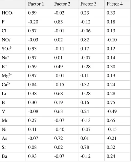
Four factors emerged from the FA application (Table 1): Factor 1, composed of Cl-, SO
42-, Na+, Mg2+, Ca2+ and Ba, represents the main salinization factor for the studied aquifer. Inside this factor is possible to identify more processes: i) the lateral inflow from carbonate massive of Massico Mountain, with a Ca-Mg-HCO3 groundwater composition, ii) the seawater intrusion near the coastline
intrusions (Kazakis et al., 2019) and finally iii) the interaction with marine sediments in the central part of the study area. The Factor 2 shows a correlation between F-, As and V, elements commonly found in groundwaters hosted in volcanic rocks. The Factor 3 consists of three species, NO3-, U and Sr. The spatial distribution of this factor suggests an anthropogenic origin of these elements like agricultural activities, and sub-urban activities (Busico et al., 2017). The last factor, with the 11% of the total variance explained, has only B that was probably released by reworked silica sediments.
Factor 1 Factor 2 Factor 3 Factor 4
HCO3- 0.59 -0.02 0.23 0.33 F- -0.20 0.83 -0.12 0.18 Cl- 0.97 -0.01 -0.06 0.13 NO3- -0.03 0.02 0.82 -0.10 SO42- 0.93 -0.11 0.17 0.12 Na+ 0.97 0.01 -0.07 0.14 K+ 0.59 0.49 -0.28 0.30 Mg2+ 0.97 -0.01 0.11 0.13 Ca2+ 0.84 -0.15 0.32 0.24 Li 0.38 0.68 -0.28 0.28 B 0.30 0.19 0.16 0.75 V -0.08 0.63 0.24 -0.49 Mn 0.27 -0.07 -0.13 0.65 Ni 0.41 -0.40 -0.07 -0.15 As -0.07 0.72 0.01 -0.21 Sr 0.08 0.02 0.78 0.32 Ba 0.93 -0.07 -0.12 0.24
Table 1 - Factor score for applied FA
CONCLUSIONS
The application of the FA describes the main hydrogeochemical processes acting in the study area. Results of this study can be widely used in coastal aquifers to distinguish between different hydrogeochemical processes, and to recognize pollution sources
References
Busico G., Cuoco E., Kazakis N., Colombani N., Mastrocicco M., Tedesco D., Voudouris K., 2018. Multivariate statistical analysis to characterize/discriminate between anthropogenic and geogenic trace
elements occurrence in the Campania plain, southern Italy. Environmental Pollution, 234, 260-269. doi: 10.1016/j.envpol.2017.11.053
Busico G., Kazakis N., Colombani N., Mastrocicco M., Voudouris K., Tedesco D., 2017. A modified SINTACS method for groundwater vulnerability and pollution risk assessment in highly anthropized regions based on NO3− and SO42− concentrations. Sci. Tot. Environ. 609, 1512- 1523. doi:
10.1016/j.scitotenv.2017.07.257
Kim K., Yun S., Choi B., Chae G., Joo Y., Kim K., Kim H., 2009. Hydrochemical and multivariate statistical interpretations of spatial controls of nitrate concentrations in a shallow alluvial aquifer around oxbow lakes (Osong area, central Korea). J. Cont. Hydrol. 107 (3-4), 114-127. doi: 10.1016/j.jconhyd.2009.04.007
Kazakis N., Busico G., Colombani N., Mastrocicco M., Pavlou A., Voudouris K., 2019. GALDIT- SUSI a modified method to account for surface water bodies in the assessment of aquifer vulnerability to seawater intrusion. J. Environ. Manage. 235, 257-265. doi: 10.1016/j.jenvam.2019.01.069
The ENeRAG project: towards a dynamic system approach for geofluids
Corrado Camera1*, Daniele Pedretti1, Ferenc Mòlnar2, Teppo Arola2, Timea Havril3, Anita Erõss3,
Marco Masetti1, Juha Kaija2, Judit Mádl-Szőnyi3
1 Università degli Studi di Milano, Dipartimento di Scienze della Terra “A. Desio”, Milano, Italy.
*Corresponding email: [email protected]
2 Geological Survey of Finland (GTK), Espoo, Finland
3 Eötvös Loránd University, Department of Physical and Applied Geology, Budapest, Hungary
ABSTRACT
Historically, physical and biochemical similarities among geofluids (e.g. shallow groundwater, geothermal fluids, hydrothermal mineral-rich fluids) have not been treated under a common research sphere. Also, little knowledge is available regarding geofluid interactions and a common legislative framework for their management and use does not exist in the EU. The main objective of the ENeRAG project is to develop a sustainable and cost-effective dynamic system approach (Tóth, 1999; Deming, 2002; Ingebritsen et al., 2006) to deal with geological resources, relying on a scientific understanding of the connections and interrelationship among geofluids.
The ENeRAG – Excellency Network Building for Comprehensive Research and Assessment of Geofluids project is a twinning project funded by the European Union’s Horizon 2020 research and innovation programme under grant agreement No 810980. This presentation covers the main development, actions and goals of the projects, highlighting key achievements and incoming milestones.
Keywords: geothermal fluids, groundwater, hydrothermal fluids, interaction, resource assessment, resource management
METHODS
The project tackles three main topics linked to geofluids: 1. Hydrogeology
2. Low enthalpy energy and reutilization of shallow subsurface heat 3. Hydrothermal formation of mineralogical resources
The core of the project consists of capacity enhancement activities (e.g. training workshops, winter and summer schools, expert visits, laboratory and field trainings) and networking programs (e.g. staff and junior researcher exchanges, co-organization of conference sessions and seminars), whose outcomes should impact both science and society through specific dissemination actions (participation in scientific conferences, scientific publications, stakeholder workshops, policy round-tables, and participation in events open to the general public). In detail, during the three years of the project, 4 training workshops mixing field, laboratory and traditional class activities; 2 summer
(winter) schools; 5 conference session, 4 staff and research exchange actions for a total of 12 project participants being hosted at partners facilities; and 1 field symposium will be organized.
Detailed directions of development of the project include: i) improvement of knowledge on geofluid systems, tracing of fluids in the underground, and transport modelling; ii) development of sustainable solutions for geofluid management and utilisation; iii) transfer of knowledge to business services and outreach to society. All research and innovation activities are implemented with a focus on knowledge-transfer among partners, since it is the pillar of twinning projects.
RESULTS
The ENeRAG project will form scientists able to follow the latest scientific developments in the field of geofluids, with the necessary skills to face related environmental issues with an integrated approach. Also, their knowledge will ideally foster and pave the way to a first concept of policies and regulations dealing with the connections between geofluids and formation, preservation and harvesting of various geological resources linked to them. A number of 10 papers will be published at the end of the course, while the exchange of 12 researchers supports the development of new skills to be adopted directly on the Hungarian territory (Hungary is the main target of the Twinning action) as well as exported within the EU and beyond.
CONCLUSIONS
Strategic and wise management of geological resources is intrinsically needed for a sustainable future development of our environments, societies and economies. Considering that fluids play a role in nearly all geologic processes and are ubiquitous in the continental crust to depths of at least 10 to 15 km (Deming 2002, Ingebritsen et al. 2006), the integrated study of geofluids, as proposed by the ENeRAG dynamic system approach, is a key element to reach these objectives.
References
Deming D., 2002. Introduction to hydrogeology. McGraw-Hill 468 pp.
Ingebritsen S.E., Sanford W.E., Neuzil C.E., 2006. Groundwater in geologic processes, 2nd edition. Cambridge University Press, 564 pp.
Tóth J., 1999. Groundwater as a geologic agent: an overview of the causes, processes, and manifestations. Hydrogeology Journal, 7(1), 1-14. doi: 10.1007/s100400050176
Depth profiles of H2O, C, N and S stable isotopes in a shallow aquifer-aquitard below
agricultural fields reveal large hydrochemical heterogeneities in contrasting soils
Nicolò Colombani1*, Ramon Aravena2, Giuseppe Castaldelli3, Micòl Mastrocicco4
1 Università Politecnica delle Marche, Dipartimento di Scienze e Ingegneria della Materia, dell’Ambiente ed Urbanistica
(SIMAU), Ancona, Italy. *Corresponding email: [email protected]
2 University of Waterloo, Earth and Environmental Department, Waterloo, Ontario, Canada
3 Università degli Studi di Ferrara, Dipartimento di Scienze della Vita e Biotecnologie (SVeB), Ferrara, Italy 4 Università degli Studi della Campania, Luigi Vanvitelli, DiSTABiF, Caserta, Italy
ABSTRACT
Lowland agricultural landscapes as the Po delta (Italy), are intensively cultivated, and often affected by large nitrogen (N) and carbon imbalances due to fertilizers leaching to groundwater and export via run-off. Agricultural-derived N imbalance usually leads to nitrate accumulation in groundwater (Paradis et al. 2018), which triggers other biogeochemical reactions linked to the carbon and sulphur cycling (Zhang et al. 2013). Moreover, since groundwater flow rates can be extremely slow in lowland environments (Colombani et al., 2016), to infer which are the most impacting land uses in term of aquifer diffuse pollution, the definition of the temporal scale of recharge and residence times is of utmost importance (Meals et al. 2010). Besides, recharge rates at field scale can be heterogeneous, affecting residence time in the vadose zone which in turn affect lag time in groundwater quality response due to agricultural practices. To verify if recharge rates are heterogeneous and determine the main biogeochemical reactions, multi-level sampler (MLS) monitoring wells were installed at two sites (GUA and BAN) characterized by contrasting depositional environments and groundwater samples were analysed for major ions and H2O, C, N and S stable isotopes. Results show high heterogeneities in recharge due to local variation of hydraulic conductivity (k). Stable isotopes provided a clear distinction between different sources of N present in both sites, from synthetic fertilizers to sedimentary N pool and atmospheric input. Nitrification was the main N transformation in the vadose zone while denitrification was restricted to a narrow transition zone between oxic and reduced zones. Pyrite oxidation was the main source of sulphate in both sites and sulphate reduction and methanogenesis were found to be active processes in the deeper part of the BAN site.
Keywords: recharge, denitrification, shallow aquifer, pyrite oxidation, redox zones
METHODS
Two contrasting soils were selected and equipped with MLSs to monitor the main biogeochemical reactions. The first site (GUA) pertains to a freshwater paleo-river environment poor in sedimentary organic matter (SOM); the second site (BAN) pertains to a coastal brackish swamp environment, characterized by SOM abundance and peat lenses. MLSs were sampled in March 2018 and slug tests