Declaration
Hereby affirm that this submission is my own work and that, to the best of my knowledge, contains no material previously published or written by another person nor material which significantly has been accepted for an award of any other degree or diploma of University or other institutions of higher learning, except where due acknowledgments has been made in the text.
Index
Abstract………...5
Introduction………...7
- Objectives……….8
- Materials and methods………..8
- Applications and expected impacts……….10
- Structure………..10
Chapter 1. A framework on the new complex city Abstract………13
Introduction………..14
1.1 How city is evolved………...18
- From egyptian city to the medieval one: the evolution of the human need to be part of a community………..……….19
- Eqyptian city………..………19
- Grecian city………20
- Roman city……….………21
- Medieval city……….………22
- The baroque city: a theatre-city………..…….23
- The industrial city: the birth of the social cities……….…….24
- Modern urbanism………....25
- The American dream vs Europe: the ideal city towards contemporary city………...26
- Smart City………...28
1.2 New urban planning approach for the complex city………...47
Conclusions………..53
References………55
Chapter 2. Open Data from Social Media as tool for better understanding complex territory Abstract………59
Introduction………..60
2.1 The use of Open Data for the complex systems………64
2.2 Mapping Open Data with GIS………...68
2.3 The use of open data for the analysis of tourist flows………...71
Conclusions……….79
Chapter 3.
Urban Magnetism through the lens of geo-tagged photography
Abstract………87
Introduction………..89
3.1 Data………....92
3.2 Definition od user home cities and countries……….93
3.3 Attractiveness………...95 - Global Attractiveness ………95 - Local Attractiveness ………...108 Conclusions ………...121 References………...126 Chapter 4. Temporal Distribution Abstract………..………131 Introduction………133 4.1 Data………..134 4.2 Temporal Distribution………..137 4.3 Spatio-temporal Attractiveness………149 Conclusions………156 References………..159 Attached Timeline Chapter 5. Barcelona Smart City: Application Case Study Abstract………..166
Introduction………168
5.1 District 22@……….171
5.2 El Raval………186
5.3 Materials and methods: Urban success story told from geo-tagged photography………....……...190
- Method………...190
- Materials………..193
- Application and results………195
Conclusions………....201
References………..203
Abstract
This research work presents a method for a new mapping process, based on social networks (especially geo-referred pictures downloaded from the websites of photosharing) to work alongside the maps commonly used in spatial planning. In the vast world of social, I choose to consider in particular the photographs, because people choose to photograph specific places or times that they consider important for some reasons. This would allow a truly innovative reading of the territory, making the concept of smart city in its dual aspects: the technological (because they take into account the social networks by creating dynamic maps of the territories) and human (because it takes into account the actual participation and objective citizens and more generally of land users, without the burden of being directly involved, but only through the daily activities that each of us carries on social networks). In this way it is possible to monitor urban areas that should be protected, managed, potentiated, discovered, making liveble and lived all the city and the territory to have smarter and safer city.
Keywords:
complex systems, smart city, mapping, big data, urbanism, gis
Introduction
“With cities, it is as with dreams: everything imaginable can be dreamed, but even the most unexpected dream is a rebus
that conceals a desire or, its reverse, a fear. Cities, like dreams, are made of desires and fears,
even if the thread of their discourse is secret, their rules are absurd, their perspectives deceitful,
and everything conceals something else.” Invisible Cities – Italo Calvino
City is where everything happens. Where we breath, where we travel, where we work and meet people. We build our life in
the city and with our life we contribute to(towards) building
the city. Everyone wants to breath, travel, work, meet people and, in general, live better. This is not the first time in which cities are so interesting for people and research, including so many fields of human knowledges, but cities have never proliferated as much as in these last 20 years and more than half of the World’s population now lives in urban areas. In this critical period for all the world, it’s clear we cannot overcome crisis if, first of all, we don’t re-think cities.
Objectives (Why this study)
[smart city, technology, urban planning]
Although for years the European scene and the world are open to the discussion about smart cities, even today the city cannot become really smart in the sense of being completely at the service of citizens. There are many initiatives, but still struggling to take off future. Someone consider smart city just as technological cities, those ones critique them because "too" technological. The proposed method is an objective method, such as human and technological participatory, to be used for planning a really smart cities.
Materials and methods (How this study)
[big data, gis, mapping, visualization, complex systems]
Always more, scientific research is talking about city as complex system. This is because in a city we can find all the features of a complex system: networks, self-organizations,
power laws describing the behaviours in the city. But these phenomena need data from mathematical and physical perspective. Obviously data is not the only one and the best way for understanding city, that is an alive body changing any time, made of people, habits, complex relationships that no data can explain: but data is surely the best way for studying them and identifying patterns, trying to improve first of all city in general and then going deeper in any city. In particular the research is always more interested in big data. So it is important to understand the challenges that big data in general can give to the city science, in particular regarding GIS and geo-localization, considering their applications in many fields such as urbanism, risk management, and so on. With all this preparedness and successful applications, the research, design and implementation of GIS around activities of smart cities and daily considerations of human social needs will lead to very active scenery in the next several years.
Applications and expected impacts (What this study is for)
[environment, urbanism, culture, society, economics, tourism]
The method also has potential applications in various fields: planning (reading area, big events, traffic, etc...), research (because data was provided to create behavioral models, prevention models, etc...), economy (because you can determine which are the most attractive/most photographed places and events, locate where people prefer to go, the links between the different cities to help you determine the prices of air travel, in which place territory agrees or not to open a business, tourism, etc...), security (prediction of disaster damage, streams, etc...), and so on.
Chapters structure
The structure of the thesis is articulated in the following way: 1. First Chapter is about the macrotheme of cities and
evolution during the history, until the new concept of smart city;
2. Second Chapter is about the materials used in the research, explaining why they are useful tools for planning and research: GIS Mapping and Big Data as new challenges for better understanding the complex territory;
3. Third Chapter is about the model of mapping geotagged photography in spatial dimension, illustrating reasons, results and applications;
4. Fourth Chapter is about the model of mapping
geotagged photography in temporal dimension,
illustrating reasons, results and applications;
5. Fifth chapter is about a case study of urban perception in Barcelona, one of the smartest city in the world, in which the model was really applied.
At the end there are the conclusions of this three years PhD research work and the exposition of applications already started or that will start.
Chapter 1
Chapter 1
A framework on the new complex city
Abstract
City is where everything happens. Where we breath, travel, work and become part of a network. We build our life in the city and with our life we contribute to build the city.
This is not the first time in which cities are so interesting for people and research, but they have never proliferated as much as in these last years as more than half of World’s population lives in urban areas. The goal of this study is accompaigning the readers in a temporal travel in the spatial change, arriving to the new city concept: the smart city, underlining how complex
changing cities, in which we reflect crisis (economic dimension), digitalization (scientific dimension) and globalization (social dimension). These aspects are actually strongly related each others: economy, science and sociology are all convergent in the macro-topic of the city.
Keywords: [urbanism, smart city, complexity,
city evolution, urban planning]
Introduction
Urbanism exists for more than 5,000 years to identify guidelines and rules in the process of city making.
It’s difficult to attribute the urban planning to only one of the two opposing worlds (artistic and scientific), but it is probably correct saying that urban planning is half science and half art. Instead own town planning can represent an easy example of a discipline that, without disintegrating between the one and the other of the two worlds cultural, belongs to a new cultural world, dialectically tending to solve the contradictions of the old one
[1]. In fact, geographers, historians, economists, urban planners and political scientists have incorporated the points of view of their respective disciplines into diverse definitions of the city, this is the reason why we can define a complete definition without excluding no one disciplines, no one capabilities, no one different lecture of the territory. Another important thing to
clarify is the relationship between Urbanism and
Industrialization. The rise of cities in the modern world is undoubtedly not independent of the emergence of modern power-driven machine technology, mass production, and capitalistic enterprise. But different as the cities of earlier epochs may have been by virtue of their development in a preindustrial and precapitalistic order from the great cities of today, they were, nevertheless, cities. Cities represent a fertile ground for developing science and technology, culture and innovation, for individual and collective creativity, memory of the past and new opportunities for the future, also for mitigating the impact of climate change. However, cities are also places where segregation and poverty are concentrated, despite the intercultural approach to the city life and a better distribution of
the richness. We need to better understand challenges and study solutions but the speed of the transformation processes, the presence of phenomena apparently belonging to different sectoral areas, the spread of technology products that change the location of activities in towns changing its shape, increase more the difficulty of reading and interpretation of urban phenomena.To this regard, the best approach to interpretation and management of a well organized system is complex. As complex systems, the cities are made up of many components, in turn complex: people, insects, roads, buildings, cars, electromagnetic fields. The research, in fact, is talking about city as a dynamic complex system. This expression is equivalent to saying that the city is due to a set of components relative to each other (system), the system processes are not manageable and controllable by means of deterministic (complex system) and, finally, the future development of the city-system is not predictable based on knowledge of the initial conditions (dynamic complex system). The dynamics governing the system-cities are almost always the result of causes not easy to read, which is accompanied by an inability to control and manage complex phenomena, not only
due to the inadequacy of the procedures adopted but also the lack of effective tools [2]. If we consider the city as a "system", characterized by the presence of numerous elements (tasks and functions) and held together by interactions and relationships among its components (communications channels), complexity theory and the analytical approach used for study of complex systems, make it possible to develop a vision of the city as a whole, because the city can be read not only as "physical phenomenon" but also as "functional phenomenon".
The result of the interaction between man and nature which he lived is the world we inhabit today, determined by the complex of events related to the special physical situations, historical, cultural, economic and social own of every place and time [3]. Men have fought to defend and extend their territories. Those who wished to do so now would be in the exciting position of those who must give shape not only material needs but also psychological, combining its own expertise and sensitivity to the needs of others, living in the same time all the difficulties related to the confusion of tastes and styles and the fact that you have lost cultural references and compositional models. On the other
hand there must be a reasoning based on logical reasons and clever thoughts as to be used as a yardstick to judge what we inherited and what you are doing and thinking about the future. Alongside the answers that involved over the centuries, the political, economic and urban, that have changed spatially urabane our reality, today the individual response can only come about by a change in aspirations and popular models: the beauty that interests us is daily, is that of the landscape "home" made up of the inside and outside of our homes, the streets that we walk normally, places that are usual and loved ones. It, when it exists and is enjoyable to all, is a symbol of great democracy in this sense is a human and social value incomparable and perhaps holds the indisputable power that distinguishes the city of the past.
1.1 How city is evolved
[4-11]
From egyptian city to the medieval one: the evolution of the human need to be part of a community
Man is a social animal and from the beginning of the time he has the need to live with the others and to be part of something with others men. Civilization is a complex way of life that came about as people began to develop urban settlements. The earliest civilizations developed after 3000 BCE, when the rise of agriculture allowed people to have surplus food and economic stability. Agricultural populations advanced beyond village life, and many people no longer had to practice farming at all. Civilizations first appeared in Mesopotamia (the actual Iraq), then in Egypt. Civilizations thrived in the Indus Valley by 2500 BCE, in China by 1500 BCE and in Central America (the actual Mexico), by 1200 BCE. Civilizations developed on every continent except Antarctica.
Eqyptian city
Egyptian cities appeared as consequence of the development of agriculture and they imposed themselve as unifying and predominant form of political organization. Cities consisted of regional capitals linked to the population centers of smaller administrative districts.
During the New Kingdom, the Egyptian word for "city" was niwt. That term refers to "settlement". Settlements and cities were located on the floodplain, with a preference for proximity to the Nile, in order to receive goods by boat and for its source of water. Generally, there was not a real urbanism, but that urbanism is considered as the hieroglyph for "city" with houses arranged rather haphazardly around the crossing of two major roads. But in a number of cases attempts at rational planning seem to have been made.
Grecian city
“Polis” is a famous word from which we derive our term “politics,” is usually translated as “city-state”, the principal reason is for emphasizing its difference from what we today normally think of as a city. As in many earlier states in the ancient Near East, the polis included not just an urban center, often protected by stout walls in later centuries, but also countryside for some miles around with its various small settlements.
Roman city
Urban design of Roman cities follows clear laws for the development of public and military services. Roman city is basically composed by a number of identic components, disposed in a special way -parallel and equal-distant separated by streets. The whole forms a unit of rectangular design surrounded by a perimetral wall with watchtowers. All the streets are equal except for two: the North-South one -kardo maximus- and the East-West one -decumanus-. Both are wider and they end at the four doors of the exterior wall. At the cross of both streets is the city's forum and the market. These urban rules were developped during nearly 10 centuries in order to create the different cities. In these cities, kinds of housing could be divided into house, domus, insula and villa. There also were casae or housings for slaves and low classes. Because of their weak systems of building they have all dissapeared in our days. Indeed, there were also great communitary buildings as basilicae, termae and the very important social and
cultural systems called forums. In Roman Hispania there was a lot of capital cities.
Medieval city
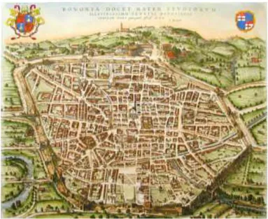
In the Middle Ages a new urban culture is developped. City became a small self-sufficient entity which restructured the territory of all Europe in tiny aggregations of towns and countries. The life fervor of this period is reflected in the urban structure, which translates in practice this dynamism exalting with paths and meeting places. The medieval town, with its own statutes and regulations, creates a small microcosm. This kind of city presents itself as an autonomous entity, circumscribed by walls, inserted in a particular agricultural landscape and recognizable for the profile of towers, roofs and spiers that summarizes the city as a collective symbol for all citizens.
Fig. 1.1 - Medieval Bologna Map
The baroque city: a theatre-city
During two centuries (from 400 to 600) we can retrace the first radical transformations in the city concepts, but it is between 700-800 that actually a new defined city idea started to move on, introducing the need of an urban design. This is the birth of the baroque city, characterized by:
- theatre; - museums; - concert halls; - a park; - a zoological garden; - poor hygiene;
- expansion of affluent residential neighborhoods at the expense of the poorest ones.
With the baroque city we assist to the definition of a new spatial model: the city is a theatre.
The industrial city: the birth of the social cities
The industrial revolution corresponded also to an urban revolution.
First of all, the steam machine represented the biggest discovery after the discovery of the wheel for the transportation field. It means that city order should have be completely upset to respond to this huge improvement of communications and transports. Due to this improvement, it was born the phenomenon of Inurbation: people started to LEAVE campaigns because they want to LIVE in the city, the place of innovations and scientific developments. In the industrial city the changes are really fast.
But the phenomenon have a double face: the fast growth of the industrial city underly also the social differences. Different social classes have to live in different spaces, that have to reflect these
differences in everything. Also speculators built everywhere to take the maximum gain.
Problems and crisis of the industrial cities are: - overcrowdings;
- increased poverty; - epidemics.
It is during this period that the concept of SLUM has born.
All these problems pointed out the need of a new kind of urbanism, a modern urbanism.
Henceforth urbanism will be never more detached from social conflicts that take place within it. It will be forever full of social meaning: endeavoring to distribute progress to all the sections of population.
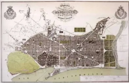
Modern urbanism
Modern urbanism is scientific and moralist, characterized by utopianism and functionalism. From Waterloo (1815) to the revolution (1848) technical and political aspects of urbanism are so close to be confounded to each others.
Fig. 1.2 - Barcelona (Cerdà)
Fig. 1.3 - Florence (Poggi)
The American dream vs Europe: the ideal city towards contemporary city
During the Modern Movement, two of the most important architects in the history, like Le Corbusier and Wright,
elaborated ideas about a new kind of city. Even if they are basically opposite in their intentions, La Ville Radieuse [12] and Broadacre City [13] have the same conceptual pattern. In both materials, ubications and insediative principles have a new strong importance, with emphasis in identifying the correct dimensions and distances between activities and estabilishing the connections. In both, building the city like a park is essential for the city architectural. Urban space is a lattix, with two hortogonal grids, rotated 45° each other, while residential areas are connected with a smaller infrastractural network. Finally, there is the requirement of a new kind of architecture, pure and closer to nature. But in a different way. In Le Corbusier, the city architecture offres a different design from nature, while Brodoacre city is completely part of the nature. This is due to a different basic reflession: Le Corbusier is based on the big 800th city, like the Plan Voisin for Paris or better on the reflessions about La Ville Verte in 1930. Instead in the Wright background there is an illuministic conception, the jeffersonian grid, based on the dream of a great form of democracy and freedom born in the big territories of the new world. In “The Living City” Wright
highlights aspects like:
1. Electrification, consenting to cancel the distances, favoring human communications;
2. Mechanical mobility, enlarging human contact possibilities; 3. Organic architecture, introducing the concept that nature is not
an element to struggle but an element to conquer in the architectural project.
Even if these ideal cities are not “smart cities” in the meaning we give it today, there are contact elements. Le Corbusier wrote : “The machine civilty has to find its architectural expression”. We are in the same conditions, but as the “digital civilty”. Our “ideal” city, the smart city, is intrisecally related to contemporaneous man and the ideal is evolving with the digital revolution.
Smart City
Modern cities are more complex systems and engines for the acceleration of human society development. At the same time, cities are consuming resources from nature and producing wastes to environments at a much higher rate than other living styles.
The problems of the contemporary city are: - Environmental pathologies;
- Congestion and pollution for cars; - Environmental resources not protected; - Lack of security;
- Urban sprawl;
- Areas of exclusion and segregation (slums).
All of these problems are strongly related each others: for example, the climate changes and social problems are causing high risks of disaster and unsustainable development to cities. These issues are also generated, because, as we already said, urban areas have been accommodating more and more inhabitants. In particular, it is expected that by 2050, urban dwellers will become 67% of the world population, which is approximately 6.3 billion [14]. But, from the other hand, this faster urbanization processes and growing population densities reinforce people’s concerns on better understanding, planning and managing their city, taking care about infrastructure, economy and society to achieve liveability and sustainability. Every urban planners, geographers, economists and citizens, all
together have the need to think and re-think the cities and their use. This context, in the period of the ICT (Information and communication technologies) revolution, couldn’t be not related to technology. Due to the high degree of complexity of urban issues, ICTs have long been used to facilitate scientists and practitioners to manage cities and improve the efficiency of many working procedures in the territories governance, or, simply, to help in many urban problems.
In particular, since a high percentage of information, especially in the planning science, is geo-referred, geographical information systems (GIS) have gained their popularity very soon in urban planning, transportation modelling, risk management and geo-demographics. As an essential part in a much wider scope of ICTs in urban management, GIS have been pioneers of many revolutionary changes in the last half century becaming a basic tool for the treatment of urban issues, like traffic flows and so on. It is possible to analyze or predict people movements also with the use of open data that we continuously left on the network, as twits [15] or pictures [16] and so on. It is very important to understand that technology should be just a service for people, it
cannot be considered a goal, as it is just a good and strong mean in people hands. “Smart city” it's used to describe the level that every city wants to reach and is playing a more and more important role. It is a kind of ideal city. For this reason it is hard to define what a smart city is.
As suggested by Holland [17], part of the problem concerns the
variety of ways the term “smart” is employed. The term “smart”, in fact, can be related to IT, technology, internet and so on. But it cannot be reduced to just this.
The concept was born during the last decade as a fusion of ideas about how information and communications technologies might improve cities, enhancing their efficiency and competitiveness, providing new ways in which problems of poverty, social deprivation, and poor environment might be addressed [18]. Universities have developed prototypes and solutions for
intelligent cities. MIT Smart Cities Lab [19] focuses on
intelligent, sustainable buildings and mobility systems
(GreenWheel Electric Bicycle, Mobility-on-Demand, Citycar, Wheel Robots); the IntelCities [20] research consortium developed solutions for electronic government, planning systems
and citizen participation; URENIO has developed a series of intelligent city platforms for the innovation economy [21]
focusing on strategic intelligence, technology transfer,
collaborative innovation, and incubation, and in the meantime is offering, through its portal, a global watch on intelligent cities'
research and planning [22]; the Smart Cities Academic Network
[23] is working on e- governance and e-services in the North Sea
region. Furthermore, influential IT and telecommunication companies such as CISCO, IBM, MS have developed new solutions and initiatives for intelligent cities. CISCO, launched the Global Intelligent Urbanization initiative [24] to help cities around the world using the network as the fourth utility for integrated city management, better quality of life for citizens, and economic development. IBM announced the aim of its
SmarterCities [25] is to stimulate to stimulate economic growth
and quality of life in cities and metropolitan areas thanks to the introduction of new ways of thinking and acting in the urban ecosystem.
But, rather than believing that IT itself can actually transform and improve cities, real smart cities must be based on the human
capital. This means that IT is a relevant side but the aim is to
enhance democratic debates about the kind of city it wants to be and what kind of city people want to live in.
Also, smart city needs to create a real shift in the balance of power between the use of information technology by business, government, communities and ordinary people who live in cities [26] as well as seek to balance economic growth with sustainabilities. Finally, cities, can only be smart if there are intelligence functions that are able to integrate and synthesise IT to some purpose, ways of improving the efficiency, equity, sustainability and quality of life in cities [27].
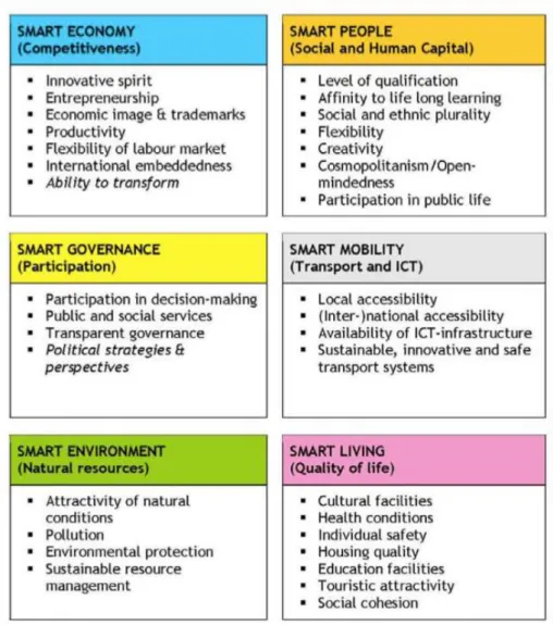
Usually the new ideal city, “SMART CITY” is considered a technological city. But it is not the case: city could be technological, but, to be really smart, it is first of all human. There are many different meanings of smart cities. Smart cities can be identified (and ranked) along six main axes or dimensions [28]. These axes are: smart mobility; smart environment; a smart people; smart economy; smart governance; smart living.
Smart mobility
Innovation and modernization of cities and territories is strongly related to mobility, that should be smart in the meaning of: highly technological, easy for citizens and green. The innovative system of smart mobility represents a new frontier for not only reduce waste and pollution, but also to create scale economies on the movement of people and goods, improving logistics through the use of technology and then saving time and costs. It is important to start thinking about mobility and shifts smoothly to make the standards of everyday life and the related behaviors more environmentally respectful and virtuous. Moving cleverly includes a public transport really efficient and environmentally friendly means for the territory protection. Smart mobility include more livable solutions with consistent and timely updates, safe cycle tracks and continuing for long stretches, park and ride facilities that avoid congestions. Smart mobility should in fact ensure a city centers access regulation, the adoption of advanced mobility management and mobile information to manage
the daily commute of citizens and exchanges with neighboring areas. Smart mobility solutions for all empowering the individual condition of having easy moving, good availability of public transport and sustainable innovative eco-friendly means. To obtain these results they need trip planning systems, route optimization and intermodal transport systems that allow the payment or
reservation in mobility technologies Car-to-Car
Communication (C2C) and Car-to-Infrastructure (C2I) but also integrated management of car sharing, bike sharing, van sharing.
Smart environment
Citizens are not only involved in the creation of the smart city, but also with individual actions, they become active participants in the process of city designing. This view is particularly significant in the creation of a smart environment, or in making cleaner the environment around. The single can intervene in this improvement process thanks to the single daily actions ranging from a
correct and efficient collection avoiding waste and not eco-friendly behaviors to the choice of alternative means for moving, for a less impact on CO2 emissions. Particular attention to recycling plans should also be paid by the Public Administrations, which should encourage good practice. In the constitution of a respected and respectable environment must also intervene individual companies, for example with business plans that optimize emissions, but also the public administration, adopting a series of behaviors of optimal management of public affairs, as saving lighting systems energy, air quality monitoring to highlight in the presence of critical situations and protection of urban green with specific actions for parks and natural areas improvement, as well as outreach activities to citizens. The renewable energy sources play a major role in the development of smart environment necessary to promote sustainable development. The building, in particular, needs to be rethought in an ecological and rationalization key that must converge more
about efficient buildings, with the consequent heating and air conditioning impact reduction.
Smart people
The smart city is created with the active participation, commitment, adherence to the territory. If it is true that a smart city must be built around the city, it is even more true that the citizens themselves must be the soul of the change of its territory with a smart view, sharing knowledge, ideas and creativity. The public and private stakeholders will choose in a smart city to put the citizen first, they are the heart of every project for the smart city. The centrality of the citizen and his civic participation has increased, especially in the case of the youngest so that enhance the human side of the city: smart citizens who inhabit a city smart. The conscious participation of those living on the territory to the life and decisions that change makes the citizens themselves protagonists of their own change. People are the which ones who choose to rethink a smarter city. A newfound awareness and participation in
public life, high levels of qualification of citizens, peaceful coexistence of different stakeholders and communities are some of the smart features that can be found in a "smart city".
Smart economy
The economy changes thanks to science and technology: the new concept of smart economy changes the global scenario. The city becomes the center of the investment and financial development; new technologies help to orient the production system to better behaviors, meeting the needs of citizens, businesses and land.
In an increasingly complex situation in terms of economic and financial, the smart economy interacts with innovative features such as business incubators for the creation of innovative start-ups, which support the growth of entrepreneurship as the creation of new ideas and their subsequent development thanks to the use of technology, the economic key and social future. The smart economy throws interesting ideas related to growth and innovation:
the window is open on competitiveness and growth, to look to the future. The smart economy must point on innovative spirit that distinguishes the smart city, with high flexibility of the labor market, productivity and entrepreneurship. The international spirit is accompanied by the ability to transform, typical of an economy "smart".
Smart governance
Changing relationships between public administration and citizens with a view to smart governance institutions, bodies, territory and individual residents can communicate in simple and functional with tools that can extend the
opportunities for conversation and democratic
participation. Dialogue and participation are the key elements of an administration that chooses to be
technological. The smart governance pursues
administrative simplification, making an important contribution to the strategy of smart city and makes the city center in their mechanisms. The Smart Governance uses the technology to make life easier for citizens: the
case of administrative simplification, necessary for the purpose of the intelligent city, which provides a virtualization of all the steps and processes. The benefits are visible both in direct service to citizens and businesses, both in the back-office management activities. A smart government has a strategic vision of their own development and knows defined according to this choices and courses of action, is able to engage citizens in issues of public importance, promote advocacy and use technologies to scan and shorten procedures administrative.
Smart living
A smart city is a place that knows how to speak to people through the latest techniques and technology applied. Even in tourism smart power components are improving the environmental and landscape enhancement of an area and creating a more sustainable use of the sites. As it is expanded and strengthened the security of the citizen, the center of technologies that assist him in the city. Valuing history, culture, art and traditions in the eyes of all: to do
this, you need to reorganize the resources and tools available to cities and at the same time creating new local services and shared through a more effective network of telecommunications and electronic communications. The contents of the smart city then become virtual to give an opportunity to everyone for enjoying city. The watchword becomes multimedia to create a digital network of orientation and a network of geo-referenced multimedia content that provide a better knowledge of the area and its peculiarities. A smart city in fact bases its growth on respect for its history and its identity: through the use of technology, it is possible to promote its tourist image on the web, by virtualizing the heritage of the city. Thanks to advanced techniques can also create paths and "mapping" issues of the city and making them easily accessible as a "common good".
Table 1.1 - Smart city levels (www.smartcities.eu)
For FORUM PA 2010 [29], smart cities are identified in 5 dimensions, that anyway can be grossly assimilated to the previous ones:
1. Mobility: a smart city is a city in which the transport is comfortable, innovative and substenible. There is an incentive of public transport and pedestrian areas,
ecological means like bikes and ITS to inform about the movement in the city.
2. Environment: a smart city is a city in which the sustainable development is very important, that means a new strong attention to improve the separate collection of rubbish and in genearl to reduce rubbish, significantly reducing gas emissions and control the energy, the building construction, the green areas and, in general, the management of urbanism.
3. Tourism and culture: a smart city is a city with an important touristic imagine, a good promotion in the web, valorising culture and territory with advanced techniques, paths and thematic maps, clear and interesting for all kind of tourists. 4. Economy of knowledge and tolerance: a smart city is a place in
which you learn continuously in innovative ways, promoting arts, culture and creativity with the right dimension and method for everyone. The knowledges have to be open and free.
strategic vision about its development, identifing the right actions to earn the objectives, valorizing the territory and enhance its identity with the help of all the citizens, thanks to a new social cohesion, without barriers between different conditions.
The smart city addresses the supranational planning policies, such as the European Cohesion Policy, that influence national planning policies and prioritize transportation networks and accessibility, entrepreneurship, education and training, and sustainable growth. Smart cities and Urban planning are closely linked to each other because both end-users and stakeholders of the smart city’s User layer are obliged to follow the planning rules and to consult in cases of framework’s construction to better understand and use the territory [30]. Thus, the user layer is influenced by all planning dimensions. For these reasons, the smart city’s infrastructures have to conform to planning rules and not to charge the local environment or the local protected areas, while planning has to uniformly develop smart cities across the regions for coherent development. This means that the smart city’s data layer must be kept up to date with accurate planning
information, in order to deliver efficient and effective e-services to the local community.
Smart cities can be classified in various approaches and can be evaluated according to their sophistication. All alternative approaches deliver emerging types of services to the local communities with the use of natural and/or of virtual resources. Urban planning supports sustainable local growth, it consists of four dimensions that were recognized according to the European Regional Policy Framework and they are:
Environmental protection that deals with qualitative
criteria such as: livability, environmental quality, quality of life and respect on biodiversity. In this context planning delimits the urbanization zones, the seashore and streams;
Sustainable residential development that covers the urban
viability timeline since it “meets the needs of current generations without compromising the ability of future generations to meet their needs and aspirations”;
Resources’ capitalization that concerns both natural and
human resources’ capitalization with means of optimal demographic allocation and decen- tralization, water and
other natural resources’ use, residential and farming allocation etc;
Coherent regional growth support that embraces the urban
history and landscape and it is based on various Government programs’ planning and implementation, which respect traditional settlements, archaeological areas, forests and parks.
We can also affirm that planning’s dimensions can be affected by smart city’s stakeholders via participatory policy making, while the smart city’s infrastructure has to be recognized and capitalized. The future challenge is try to interrelate the physical and the digital space of a smart city with tangible measurement. In conclusion, a city can be considered smart when it is able to improve the its citizens lives, to meet their needs, those of enterprises and institutions in the technology, communication, mobility, environment and energy efficiency fields.
Even at European level [31], initiatives are born with the aim of transforming an urban community in a smart efficient and socially innovative one, where there are supported and implemented projects ranging from ecosostenibility of urban
development to the energy waste and pollution reduction through better urban and transport planning. Smart city is a city easy to use, technological and for citizens. Only starting to build smart cities we will be able to have a smart world, to change it [32].
1.2 New urban planning approach for the complex city
With smart cities, we are building a new equation with space, people and technology.
The urban project consists in complex processes correlating to mathematic and geometry, in fact the complex systems theory is the right way to understand and measure form evolution and wholeness of our cities. The complexity, developped from Seth Lloyd, a phisicist from MIT and Santa Fe Institute, left a mark in the scientific culture, ranging from informatics, biology, economics and engineering applications. The big intuition is the method, studying not the single parts of a system, but directly the whole system. This concept introduces the essential elements of complexity: chaos, fractals and networks, so we can study the
elements of a system and their connections with themselves and with the rest of the environment.
This ‘new mathematic’ is easily adaptable to describe and study architecture and urbanism. From the beginning of ‘60, there are many studies about these relations between mathematics and city in general, with emphasis in wholeness and Pattern Language [33-35] while the new studies, in ’90, are more about the fractal geometry descripting the urban models [36] and the relations between the different components of the urban system [37-38]. It’s possible to define 3 principles on which should be based the urban structure:
1. activity vertices; 2. connections;
3. hierarchy, garanteeing the components will be grouped progressively from the smaller to the bigger ones.
From these principles, Salingaros elaboretad a framework rules about the urban project [39]:
1. urban components should be standardized to universal laws for the dimensions intercourse, with attention to protect the ‘small’ elements, closer to human scale, to the
invadence of the ‘big’ elements;
2. city works with flow networks, so it’s very important to structure well transportation networks and connections between the activity vertices in the city and with other cities;
3. city should encourage intermodal transportation;
4. neighborhoods should re-define their streets, enhancing vivibility in thier spaces (a good example in this sense can be the woonerven in The Netherland);
5. where communications lines intersect each others it’s important to improve and reinforce the weaker components (like pedestrian crossing);
6. office buildings shouldn’t be isolated, but re-inserted in the urban contest and reachable by the pedestrians thanks to pedestrians areas;
7. more mixed-purpose buildings;
8. building facades should be a connection elements in the urban contest and not a forced separation between the spaces;
should define the urban space, avoiding isolated buildings; 10. a neighborhood is a place in which each point inside it can
be reached in 15 minutes walk. Each barriers (big parking areas, highways, etc…) should be outside the neighborhood, defining a confine for it.
In addition, many times quantitative indices are not well integrated with qualitative parameteres, perceived from city users [40]. We have to consider many elements when we study the city [41-42]. In fact, for Bettencourt, cities are not only concentrations of people, but better concentrations of social interactions (friendships, work relations, etc…). In the Bettencourt model, cities are a complex system different from organisms or river networks, because city evolves not only to minimize the energy waste, but also to maximize social interactions. For these studies, we know there are two important factors characterizing the city: dimension and specific identity. Big city has advantages respect a small city: there are better infrastructures, efficiency and new ideas and developments are faster to assert, but also the criminality. The behavior is super-linear, that means when the number of citizens becomes double,
each citizen earn 15% more, is 15% more innovative, but he has also more 15% possibility to be a crime victime. People want to move in big cities to improve their productivity and enahance their social interaction, even if life is more cahotic or expensive. Also, when city dimensions become double, it needs only 85% of resources more. But there are some cities that don’t follow this rule. The gap is explicable with the specific identity of the city, its particular history.
Calling 𝐺 the variable indicating the socio-economic interaction levels in a territory.
If 𝐺 𝑚𝑖𝑛 = 0 ⇒ there aren’t social interactions, and then there
isn’t any city.
Calling 𝐺∗ = 𝐺𝑜𝑝𝑡𝑖𝑚𝑢𝑚:
If 𝐺 < 𝐺∗ ⇒ city can improve quality of life, because that
means the city doesn’t realize its socio-economical potentiality;
If 𝐺 > 𝐺∗ ⇒ city is victime of its own success, because
its energy waste increase super-linearly with a bigger tax respect to the socio-economical output.
Invariants of urban complexity that characterizes the modern city and, above all, that of the technologically advanced countries can be traced to particular phenomena that spread with increasing intensity and that mark the difference between the organization of the current city and that of the city's past. These phenomena refer specifically to three conditions connoting the current city [43]:
1. the concentration, 2. the specialization, 3. the integration.
The first condition refers to the high concentration of physical activity in urban and metropolitan. The second refers to the increasing specialization of urban activities and subways that can also be read as a direct result of the high concentration. The first two conditions require, therefore, the strong functional integration between assets and groups of assets. The concentration, specialization and integration of generating such synergies in urban and metropolitan system to characterize the city as the "place of complexity" because the complex is the
system of relationships and activities and, therefore, the organization of the city.
Conclusions
The interesting challenge in the new urbanism is re-thinking the methodological approach for the urban planning, that should be based on the complex systems, considering urbanism consists in social processes strongly connected to the geometrical component. We have to interpretate the urban space like an human body, with its dynamics, its history, its evolution.
In this study we made a temporal travel with an excursus of the city evolution. The analysis of the planning’s dimensions and of the city’s architecture layers shows various meeting points with the new city concept. Nowadays city is one of the most important and discussed topic in so many the research fields. We are living an historical radical change about city structure and concept, but we are not able to understand and stand up to it if we don’t know why this change is happening: to know why, we have to learn from the past, from the historical city evolution.
In conclusion, the city is a system characterized by an inextricable complementarity between "phenomena disordered" and "phenomena organizers", that self-regulate a subsequent state of equilibrium.
As occurs in natural systems, to govern a system of this type is necessary to understand the overall structure; you have to know what they are and how they interact with the parts of the system,
the differences are transformed into oppositions and
complementarities in antagonisms.
In other words you need to know the elements of a metro system and the laws that regulate the mutual relations to identify the many dysfunctions and serious internal abnormalities.
The systemic functional conception of the city can be traced back directly to the general systems theory, which, applied to the urban phenomenon, allows the construction of a model of relevant inquiry to interpretation and decoding of urban complexity. In this sense, already in reading and analyzing system-city you need to combine the characteristics of individual parts of a system to the characteristics of the system, trying to
find the interrelation that binds the individual parts to the whole and vice versa.
Complexity is the new outer reach in the urbanistic research and it’s the basic way to understand and plan the smart city, our new city. But what actually is a smart city? There are different meanings for smart cities that we tried to put together. What we can say is that with smart city we are going to define a new equation with people, space and technology and the planning science has to be prepared to build this equation with the complexity.
References
[1] G Campos Venuti, “Amministrare l’urbanistica”, PB Einaudi 1967 [2] C Gargiulo, R Papa, Caos e caos: la città come fenomeno complesso
1993
[3] A Middea, Identità, cultura, paesaggio: costruzione di una responsabilità condivisa. Book of Acts of the 9th Congress "Virtual City and Territory". ISBN: 978-88-97524-15-1
[4] G Astengo, voce “Urbanistica”, in Enciclopedia universale dell’arte, vol. XIV, Istituto per la collaborazione culturale, Venezia-Roma 1966
[5] A Bianchi, Frammenti. Sulla città, l’urbanistica e dintorni, Rubettino, Soveria Mannelli, 1998
[6] A Bianchi, lettura critica del saggio di V.G. Childe, The urban Revolution, in Sara Rossi (a cura di), Invito alla lettura, Cinquanta importanti testi del Novecento di architettura, urbanistica, arte e
[7] F Brunetti, Profilo storico dell’urbanistica, dalle origini al Settecento, Padova, 1978
[8] G Fera, Urbanistica, teoria e Storia, Gangemi editore, Roma 2002 [9] M Morini, Atlante di storia dell’urbanistica, Hoepli, Milano, 1963 [10] L Mumford, La città nella storia, Bompiani, 1994
[11] E Salzano, Fondamenti di urbanistica, Laterza, Roma-Bari 1998
[12] CE Jeanneret-Gris (Le Corbusier), La Ville Radieuse 1935 [13] FL Wright, The living city 1958
[14] [United Nations, Department of Economic and Social Affairs, Population Division, World Urbanization Prospects: The 2011 Revision
[15] B Hawelka, I Sitko, E Beinat, S Sobolevsky, P Kazakopoulos, C Ratti, Geo-located Twitter as proxy for global mobility patterns." Cartography and Geographic Information
Science 41(3): 260-271, 2014
[16] S Paldino, I Bojic, S Sobolevsky, C Ratti, & MC González (2015). Urban magnetism through the lens of geo-tagged photography. EPJ Data Science, 4(1), 1-17.
[17] RG Holland (2008). Will the real smart city please stand up? Intelligent, progressive or entrepreneurial?. City, 12(3), 303-320. [18] C Harrison, B Eckman, R Hamilton, P Hartswick, J
Kalagnanam, J Paraszczak, and P Williams. Foundations for smarter cities. IBM Journal of Research and Development, 54:1–16, 2010. [19] http://cities.media.mit.edu/
[20] http://intelcities.iti.gr/intelcities. [21] "Intelligent City Platforms" / URENIO [22] www.urenio.org
[23] http://www.smartcities.info/aim [24] www.cisco.com
[25] www.ibm.com
[26] A Amin, D Massey, and N Thrift (2000) Cities for the Many
Not the Few. Bristol: Policy Press.
[27] M Batty, KW Axhausen, F Giannotti, A Pozdnoukhov, A Bazzani, M Wachowicz... & Y Portugali (2012). Smart cities of the future. The European Physical Journal Special Topics, 214(1), 481-518.
[28] EUROPEAN SMART CITIES: www.smartcities.eu [29] FORUM PA 2010: www.forumpa.it
[30] LG Anthopoulos , and AVakali, Urban Planning and Smart Cities: Interrelations and Reciprocities
[31] A Caragliu, C Del Bo, P Nijkamp: Smart cities in Europe. Research Memoranda Series 0048 (VU University Amsterdam, Faculty of Economics, Business Administration and Econometrics). CRC Press, Boca Raton (2009)
[32] B Murgante, G Borruso (2015) “Smart Cities in a Smart World”, in Rassia S. and Pardalos P. (edited by), Future City Architecture for Optimal Living, Springer Verlag, Berlin, pp 13-35 DOI: 10.1007/978-3-319-15030-7_2 ISBN: 978-3-319-15029-1
[33] C Alexander, The Nature of Order, Voll. 1,2,3,4, New York, Oxford University Press, 2000
[34] C Alexander, S Ishikawa, M Silverstein, M Jacobson, I Fiksdahl-King and S Angel, A Pattern Language (New York, Oxford University Press), 1977
[35] C Alexander, H Neis, A Anninou and I King, A New Theory of Urban Design (New York, Oxford University Press), 1987
[36] M Batty and P Longley, Fractal Cities (London, Academic Press), 1994
[37] B Hillier, Space is the Machine (Cambridge, Cambridge University Press), 1996
[38] WRG Hillier and J Hanson, The Social Logic of Space (Cambridge, Cambridge University Press), 1984
[39] NA Salingaros, Principles of Urban Structure, Delft University Press, Delft, Holland, 2005
[40] G Antonucci, M Barile, V Biondi, B Centrone et al. (Puglia@service): Modelli Matematici per l’analisi delle città: approcci per le Smart City, 2013
[41] L Bettencourt, The Origins of Scaling in Cities, Science 340, p.1438, 2013
[42] L Bettencourt, J Lobo, D Helbing, C KŸhnert, West GB Growth, Innovation, Scaling, and the Pace of Life in Cities. In: Proceedings of the National Academy of Sciences, pp. 7301–7306, 2007
Chapter 2
Chapter 2
Open Data from Social Media as Tool for
Better
Understanding
Complex
Territory
Abstract
Data are becoming increasingly important nowadays, because they represent a concrete and inexhaustible source of information, which could be transformed into knowledge. Then, knowledge is synonymous with resource, because it represents a source of personal and community enrichment and, at the same time, it allows to accomplish more aware actions and to take advantage of every moment of freedom that comes from it. Thanks to today's technology, that creates services in response to the growing needs of citizens, public administrations and
and immediate ways. An important tool, particularly with regard to more precise issues, such as security, economy or quality of life, is Geographic Information System, since it allows not only to represent the collected data in an immediate way, but above all to provide it with georeferencing, and, then, to spread it through mappings, easily interpreted also by non-experts.
Keywords: [Big Open Data; collective sensing; community; territory]
Introduction
The meaning of Open Data can be clarified by using one of the commonly accepted definitions provided by the Open Data Manual, the “Bible” for anyone who wants to embrace this philosophy, which describes it as:
“[...] data that can be freely used, reused and redistributed, with the only limitation - at most - of the request for allocation and the
redistribution of the author in the same way, so without any change.”
As highlighted above, we talk about “open” data, i.e., freely transmitted and distributed information, that is exchanged in the network in ways that provide for the total absence of forms of control (such as copyright and patents) and other restrictions that may limit the use, integration and reuse.
Starting from the concept of open knowledge as outlined by the Open Knowledge Foundation (a no-profit foundation founded on 24 May 2004 in Cambridge with the aim to promote open content and Open Data), Open Data can also be characterized by the same principles:
availability and access: data must be available in a
convenient and modifiable form, preferably by
downloading it from the Internet. Data must be available in a useful and editable format;
reuse and redistribution: data must be provided so as to
allow its reuse and redistribution, this includes the ability to combine it with other databases;
Universal participation: everyone should be able to use, redistribute and reuse data, without any discrimination towards application areas or people or groups.
Open knowledge is a prerequisite for collective intelligence, through which it is possible to implement the main practical advantage of the opening that is to exponentially increase the ability to control, certify, explore and combine different databases and then develop new products and services [1].
The use of Open Data is also connected to the tools used for its cataloguing, processing and representation. Since most data are equipped with a system of coordinates that make the data itself georeferenced, it is logical to connect the subject with the Geographic Information System (GIS), a system designed to receive, store, process, analyze, manage and display data geographically; GIS, in fact, allows to work on maps and to show, through an endless series of layers, all the features that are highlighted in a given territory.
But why should research about urban planning be so much interested in these technologies?
1. Because, in the short period, the distance between the digital and the real world becomes shorter and shorter; 2. Because researchers have been very good in the last few
years at talking about new technologies, but not as good at understanding how these technologies can actually improve our lives.
It is time to explore these issues, so, the question should be: How can we extract added value from these datasets that are constantly increasing? Everything comes together for creating abundance of data.
Collective sensing is focused on the human aspect that can be drawn from this data, and it would be quite interesting to understand how data can be representative of some collective phenomena, such as mobility, transportation, tourism, etc.
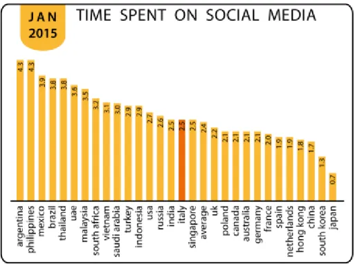
One area that has much interest in Big Data and Collective Sensing is, in fact, tourism. As it will better explained later, tourism in Italy represents 10% of the national Gross Domestic Product (GDP). However, nobody knows how many tourists are present at a given time in a specific area of our nation. These details can be retrieved only with great expense in terms of time
and costs, and after a certain period; it is the same case of a company that does not know who its users are, it is unfamiliar with its production cycles, and that, by working in this way, is bound to fail [2]. Big Data can help in this situation, providing knowledge about what happens and also analyzing it.
The work presented is divided as follows: Section II explains the importance of Big Data to analyze complex cities and to help decision makers to invest in and improve this kind of cities; Section III describes how GIS can be used as a tool to mapping Open Data, Section IV provides an example of the application is presented, and Section V concludes the work with some considerations.
2.1 The use of Biga Data for the complex cities
“Big Data” is a huge collection of such complex datasets as to require the use of different tools as compared to traditional ones in all phases of the process: acquisition, also through sharing, analysis and visualization. The increasing size of the dataset is related to the need to analyze a single dataset, with the aim of
extracting additional information as compared to what could be obtained by analyzing just small series of data, for example, the analysis to gauge the “mood” of the markets and trade, and thus, the overall trend of the company and the flow of information travelling and passing through the Internet.
Big Data also represents the interrelationship of data from potentially disparate sources; these are structured set of data, such as databases, but also unstructured ones, such as pictures, emails, Global Positioning System (GPS) data, as well as information taken from social networks. So, we can talk about “Big Data” when we have a large dataset which requires unconventional tools to extract, manage and process information within a reasonable time [3]. This issue is ever changing because machines are getting faster and datasets are getting bigger. According to a 2001 study [4], the analyst Doug Laney defined the growth model as a three-dimensional one (model of “3V” [5]):
volume: is the size of the data set;
velocity: is the velocity of generation of the data; there is a
tendency inherent in making analysis of the data in real time or nearly so;
variety: refers to the various types of data from different sources (structured and unstructured);
This model, summarized in Fig. 3.1, is still valid, although in 2012 the model was extended to a fourth variable V to indicate the veracity of the data [6], i.e., the informative value that you can extract.
Over time the model was extended, adding the following features:
variability: this feature can be a problem because it refers
to the possibility of inconsistency of data;
complexity: the huge size of the dataset increases the
complexity of the data to be managed; the most difficult task is to link the information to obtain interesting outputs.