PhD Thesis
Development of sustainable strategies for conservation
and management of Posidonia oceanica, (Linneo) Delile
1813, meadow: a case study within a Site of Community
Importance
UNIVERSITÀ DEGLI STUDI DELLA TUSCIA DI VITERBO
DIPARTIMENTO DI ECOLOGIA E SVILUPPO SOSTENIBILE
DOTTORATO DI RICERCA IN ECOLOGIA E GESTIONE DELLE RISORSE BIOLOGICHE XXI CICLO
CODICE BIO/07
Development of sustainable strategies for conservation and management of Posidonia oceanica, (Linneo) Delile
1813, meadow: a case study within a Site of Community Importance
Coordinatore: Dott.ssa Roberta Cimmaruta
Tutor: Prof. Eugenio Fresi
A Nonno Pippo e alla danza, perchè mi accompagnino sempre.
INTRODUCTION ... 1
1.1 Posidonia oceanica, species and ecosystem ... 1
Main habitat features, ecology and variability ... 2
Species that depend on the habitat ... 4
Related habitats ... 6
Ecological services and benefits of the habitat ... 7
1.2 The Habitats Directive... 9
1.3 Trends and threats of Posidonia meadows ... 13
Trends... 13
Threats... 15
Climate change effects ... 15
1.4 Conservation of Posidonia oceanica meadows... 16
Ecosystem approach ... 19
1.5 Qualitative reasoning modelling ... 20
2. METHODOLOGY... 23
2.1 The Studying Site ... 23
Morphological framework... 24
Socio economic framework... 27
2.2 Biocenosys mapping and site boundaries assessment... 28
2.3 Posidonia meadow conservation status evaluation ... 30
Building best expert knowledge ... 30
2.4 Human activities and threats ... 41
Identification of impacts... 46
2.5 Conservation strategies identification ... 49
Management Strategic priorities ... 51
2.6 Model goals ... 54
2.7 Model implementation ... 55
System environment and external influences... 57
Assumption concerning structure... 57
Entities, agents and configuration ... 57
Causal model and quantities overview... 58
3. RESULTS... 65
3.1 Biocenosys mapping and site boundaries assessment ... 65
Map and perimeter ... 65
3.2. Posidonia meadows conservation status assessment... 67
Data analysis ... 67
Documentation on similar meadows in the same area ... 68
3.3 Human activities at the site ... 72 3.4 Conservation strategies... 83 3.5 Model results ... 84 Scenario overview ... 84 Scenarios ... 85 4. DISCUSSION... 92
4.1 Biocenosys mapping and official information assessment... 92
Map and perimeter ... 92
Official Standard Data Form and Map assessment ... 94
4.2. Posidonia meadows conservation status assessment... 95
PosiPred... 96
4.3 Human activities at the site ... 98
The impacts at the site ... 100
4.4 Conservation strategies... 104
Objectives of the management Plan ... 105
Management Plan structure ... 105
Specific Objectives... 107
Updating the Official SDF ... 111
4.5 Qualitative reasoning model ... 111
Dead end simulations ... 111
Model discussion... 112 5. CONCLUSION... 115 Acknowledgements... 118 References ... 119 Annex 1... 144 Annex II... 151
1
1. INTRODUCTION
1.1 Posidonia oceanica, species and ecosystem
The species Posidonia oceanica is endemic to the Mediterranean Sea. It forms extensive underwater meadows that grow on rocks and sandy bottoms in clean water at a depth from less than 1 meter to over 40 meters (Hemminga and Duarte, 2000). The rest of the Posidonia species (of which there are 7-8) are found in Australian waters, which illustrates the antiquity of the genus (den Hartog, 1970). This seagrass is a strictly marine species and is never found in estuaries or salt-marshes.
Specifically the taxonomy indicates Posidonia as monocotiledone of the Potamogetonaceae family; it has strap- shaped leaves 40-50 cm long and 5-9 mm wide, with 13-17 longitudinal veins; apex obtuse to emarginated. Peduncle 10-25 cm long, bearing 1-4 spikes, each with 2-5 flowers; stigma with numerous irregular branched or unbranched processes. Fruit ovoid, 10cm long. This species is the most robust seagrass in the Mediterranean region and can be easily identified by the numerous brown fibrous remains of old sheaths covering the rhizomes like a paintbrush.
Its flowers are hermaphrodite on an inflorescence spike (den Hartog, 1970). The seeds develop as monocarpic fruits. P. oceanica has low flowering frequencies and sets few seeds (Buia and Mazzella, 1991). Seagrass meadows can be found along the entire Mediterranean coast, forming a kind of belt on the intralittoral zone, until maximum 40 m deep in very clean water (Bouderesque & Meisnesz, 1982, Mazzella et al., 1986).
Like other plants Posidonia has roots, stem, leaves, flowers and fruits. At the base of each plant is a rhizome, which is actually a modification of the stem, out of which grows roots of 10 to 15 centimeters in length. These attach the plant to the substratum. Large
2
leaves grow from the rhizome each about 1 centimeter wide and up to 80 centimeters long.
The scientific name, Posidonia oceanica, seems strange as this plant only grows in the Mediterranean sea. However, Seagrass thrived and spread in the warm Tethyan seas of the Eocene. The present global distribution is likely to be far more limited than in the past due to continental drift, temperature changes and the impact of enormous variations in sea levels since the Pleistocene (80m lower/42 m higher than present), (Coles and Lee Long, 1999).
Main habitat features, ecology and variability
P. oceanica is a large, slow-growing seagrass , eventually forming a tightly knit set of rhizomes that holds the sandy seabed in place. It forms dense green meadows whose leaves can attain 1 meter in height during the summer, reaching heights of 4 meters above the seabed, producing reefs.
Old leaves are shed throughout the year, but especially in the autumn. In winter, the canopy appears shorter and sparser (10 to 40 cm high). Meadow density is maximal in shallow water (when it may attain more than 1000 shoots m-2) and decreases exponentially with depth
(70-80 shoots m-2 at 30 m). Enhanced sedimentation, combined with
vertical rhizome growth, produces characteristic reefs called “matte”. The matte is a network of dead rhizomes with shell/organic debris and sediments, which accumulate over centuries to attain several meters in height (Hemminga and Duarte, 2000).
P. oceanica meadows are able to support a relatively wide range of temperatures, as deduced from the wide latitudinal range of its distribution, from 31ºN in the coasts of Lybia to 45ºN in the Gulf of Trieste (Green and Short 2003). Therefore, although there are not specific experiments, from this latitudinal distribution we can deduce that the plant endures temperatures from approximately 10ºC to 29ºC.
3
P. oceanica needs clear, oligotrophic and oxygenated waters to survive. The depth to which the meadows grow is often limited by light (Duarte et al., 2007). The minimum light requirements of this plant are 0.1 - 2.8 mol PAR photons day-1 m-2 (Gattuso et al., 2006). P.
oceanica also supports a narrow range of salinity, from 33‰ to 39‰ (Fernández-Torquemada and Sánchez-Lizaso 2005), however it is possible that East Basin populations may support higher salinities. The seagrass uses the underwater substrate for anchorage and nutrient uptake. Sediment has to be relatively oxic (ie oxygenated). P. oceanica can grow on rocks or sandy bottoms. Muddy substrates are however not suitable as the plant is unable to attach itself and the water is too murky for plant growth.
The sedimentation/erosion balance also often limits meadow development. As a result, P. oceanica never grows near river mouths or in confined waters (e.g. hypersaline coastal lagoons). Wave action is another important criterion: in sheltered bays, meadows can grow up to the water surface, forming fringing reefs, but in open coasts they usually start growing several meters below the surface (3-10 m). There are slight morphological and genetic differences between P. oceanica meadows from different regions. In particular, there is a genetic cleavage between the Eastern and Western Mediterranean meadows, which suggests that these meadows were temporally isolated from each other during last glaciations (Arnaud-Haond et al. 2007). Nevertheless, there are no clear geographical differences in meadow structure and function between the two basins, and the morph type differences disappear after some years of acclimatisation when transplanted to another site (Meinesz et al., 1993).
P. oceanica meadows constitute one of the main climax stages of Mediterranean coastal ecosystems. They harbour a highly diverse community, which varies according to depth, shoot density, adjacent communities, physico-chemical conditions and even historical events linked to larval recruitment (Hemminga and Duarte 2000).
4
Some species indicate seagrass perturbation: the overgrowth of epiphytic algae and especially the episodic formation of dense mucous layers of filamentous algae (Ectocarpales and Crysophyceae) on the meadow canopy is associated with water eutrophication and reduced hydrodynamics (Lorenti et al., 2005). The green algae Caulerpa spp. invades declining sparse meadows, especially when the sediment is enriched with organic matter (Terrados and Marbà, 2006). When nutrient inputs to the bed are too intense, sea urchins Paracentrotus lividus (normal densities 0-5 urchins m-2) become over
abundant (may attain 30 urchins m-2) on meadows that grow near rocky substrates and consequently overgraze P. oceanica leaves (Ruiz et al. 2001). Their excess is therefore indicative of habitat eutrophication. Fire worms (e.g. Hermodice carunculata) also appear in degraded meadows with an excess of labile organic matter.
Species that depend on the habitat
A conspicuous and complex epiphytic community lives on the leaves of P. oceanica. This community is composed of large quantities of micro- (mainly cyanobacteria and diatoms) and macro-algae (over 94 species described). In healthy meadows, the red algae Fosliella spp. and Hydrolithon spp., and brown algae, like the complex Giraudio-Myrionemetum orbicularis Ben, 1971, cover the tips of the leaves. Sessile animals, such as hydroids (over 44 species identified such as the obligate taxa Sertularia perpusilla and Plumularia obliqua posidoniae), or briozoa (more than 90 species, like the obligate taxa Electra posidoniae and Lichenopora radiata) are also a common component of the leaf epiphytic community. Microscopic foraminifera are also very abundant, especially in the less illuminated leaf-sides (e.g. Quinqueloculina spp., Planorbulina mediterranea, Nubecularia massutiana or Conorboides posidonicola). Some species and associations of foraminifera are exclusive of Posidonia meadows and are currently used by palaeontologists to diagnose the existence
5
of ancient meadows in geologic strata (Colom, 1974).
Within the rhizome substrate, some sessile species are only found on healthy P. oceanica meadows. This is true of the foraminifer Miniacina miniacea (whose shells are responsible for the characteristic pink colour of Mediterranean biogenic sands) and the large fan mussel Pinna nobilis, which, due to their filter feeding habits, longevity and slow growth, are good indicators of water quality and mechanical stability within the meadows. Other sessile species, such as the filterer worm Sabella spallanzanii are also indicators of water quality, but they are not restricted to Posidonia meadows (they also appear in rocky habitats). Algae adapted to low levels of light intensity (more than 74 species described, mostly red algae) colonize the rhizomes (e.g. Peyssonnelia squamaria and Udotea petiolata). Light dependent algae like Jania rubens may appear on meadow borders.
Mollusca (more than 185 species described) and Crustacea (more than 120 species of Copepoda, Decapoda and Amphipoda) are the most abundant faunal groups in P. oceanica meadows. There are some obligate taxa like the perfectly cryptic Idotea hectica and Limnoria mazzellae (Isopoda) or Hippolyte inermis and Palaemon xiphias (Decapoda). The Polychaeta are very abundant also (more than 182 species, like Platynereis dumerlii and Syllis spp.), although most species are ubiquitous. Sponges are abundant in the rhizome substrate (more than 15 species, like Clathrina contorta and Sycon ciliatum).
Among the Echinoderms, irregular detritivore sea urchins like Echinocardium and Spatangus spp. and regular herbivore sea urchins like Spharaechinus granularis and Paracentrotus lividus are common. The rare Centrostephanus longispinus can also be found in deep, rocky meadows. There are also Crinoidea (Antedon Mediterranea) and sea stars (e.g. Ophioderma longicaudum or the endangered, obligate species Asterina pancerii) but the most
6
abundant Echinoderms are sea cucumbers (16 species described) which play an important ecological role as sediment filterers. Among them, Holothuria tubulosa redominates in dense, sandy meadows, while H. polii is more prevalent in sparse or degraded meadows, although it is very difficult to distinguish these two species. At night, many mobile species living within the rhizomes migrate to feed in the canopy.
Many fish species live in the P. oceanica meadows during their juvenile stage. There are also resident species, the most common of which are Gobius spp. (living on rhizomes), as well as Labrus merula, L. viridis (cryptic, specialist), Symphodus spp., Diplodus spp, Sarpa salpa, Coris julis and Chromis chromis. There are also some obligate species living within the leaf canopy, like the cryptic species Opeatogenys gracilis and Syngnathus typhle. The endangered species Hippocampus hippocampus is also found within the canopy.
Finally, the herbivorous green turtle Chelonia mydas feeds on tender seagrass leaves. Today it is an endangered species, but only a century ago, its population was probably several orders of magnitude larger. Their ecological role as seagrass grazers could have been of great importance in the past, judging by the effects they have on tropical underwater meadows (Jackson, 2001).
Related habitats
In soft bottoms, P. oceanica meadows are usually surrounded by fine-grained sand detritic communities (Natura 2000 codes 1160, 1110). They are often combined with facies of the smaller and sparser 4 seagrasses Cymodocea nodosa or Zostera noltii (the latter is more frequent in northern regions) or with the green alga Caulerpa prolifera. Sandbanks and dune systems accumulate large amounts of seagrass litter and biogenic sand, which is formed by the calcareous and siliceous debris of epiphytic fauna and flora. In turn, sediments may be exported from the beach to the meadow, determining their
7
erosion-siltation balance (Medina et al., 2001). Therefore, the two habitats are strongly linked. Saltmarshes can also regulate nutrient inputs into seagrass meadows (Valiela and Cole 2002).
Cymodocea nodosa, it’s a similar seagrass, forming less dense meadows, with smaller rhizomes (maximum few mm wide), it can overcome stressing situation better (Cavazza et al, 2000), usually it is common on instabile sandy bottoms with fine granulometry; for these reasons Cymodocea can be define as pioneer species, colonizing areas left by Posidonia after an environmental stressing situation (Bianchi & Peirano, 1995; Relini et al., 2000); in fact it is often found on dead matte (Tunesi, 2001).
On rocky coasts, P. oceanica meadows are usually preceded by rocky algal communities (Natura 2000 code 1170).
Deep meadows may be followed by soft-bottom maërl (red coralline slow-growing algae) assemblages or by coral/gorgonian communities. The former are important and sensitive communities, which still lack formal protection (only two maërl-forming species are protected in the Annex V of the Habitat Directive: Phytomatolithon calcaereum and Lithothamnion corallioides, their Mediterranean counterparts are not).
The environmental requirements of submersed associated habitats are similar to those of P. oceanica meadows, although C. nodosa and Z. noltii support a wider salinity range.
Ecological services and benefits of the habitat
Posidonia oceanica meadows are key ecosystems within the Mediterranean Sea. The high rate of plant production (0.25 ± 3 kg (dry weight) m-2 year-1 (Ott, 1980, Pergent-Martini et al., 1994),
mainly due to annual leaf growth, and the abundance of epiphytes (which can reach up 20–30% of the biomass of leaves), support a high secondary production in situ and in detritivore compartments of other communities (around 80% of total production, Cebrián and
8
Duarte 2001), thereby sustaining complex food webs from beaches to bathyal areas.
A moderately wide (1 km) belt of P. oceanica meadow may produce litter in excess of 125 kg of dry seagrass material per meter of coastline each year (mostly during Autumn). This material accumulates on the beach, developing cushions up to 4 meters high, which can in turn sustain a complex invertebrate food web, protect the shoreline from erosion, deliver sand in the form of carbonate and silica shells and, when transported further inland by the wind, act as seed material for dune formation (Borum et al. 2004).
In daylight, P. oceanica meadows oxygenate coastal waters (Bay 1984), producing net oxygen releases to the atmosphere above the meadows. Due to the slow decomposition of lignified rhizomes and roots, the reef structure or “matte” acts as a long-term carbon sink (e.g. Gacia et al., 2002). The leaves and rhizomes increase the surface available to sessile species and offer shelter to mobile species, thereby sustaining a diverse community (Templado, 1984). Posidonia beds are especially valuable as nursery grounds for several commercial species (Francour, 1997).
The leaf canopy increases particle retention (e.g. Terrados and Duarte, 2000), so enhancing water transparency. This function, combined with the active formation of calcareous and silica sand from shelled organisms (Canals and Ballesteros 1997) and cushions of seagrass litter, all contribute to reducing shoreline erosion. Specifically the presence of P. oceanica enhances sediment stability by preventing resuspension, despite a marginal effect of the vegetation on the primary sediment deposition. These results thus support recent conclusions on the role of seagrasses in near-shore sedimentary processes (Fonseca, 1996) indicating that much of the seagrass erosion prevention is due to sediment retention.
Posidonia leaves slow down wave movement and trap larger grains of sand. It is thanks to this natural filter that the water that reaches the
9 shore is clearer and cleaner.
Finally, P. oceanica meadows are excellent indicators of environmental quality as they can only grow in clean unpolluted waters. Moreover, their rhizomes concentrate radioactive, synthetic chemicals and heavy metals, recording the environmental levels of such persistent contaminants.
1.2 The Habitats Directive
The continuing deterioration of natural habitats and the threats posed to certain species are one of the main concerns of European Union (EU) environment policy. The Habitats Directive (together with the Birds Directive) forms the cornerstone of Europe's nature conservation policy. It is built around two pillars: the Natura 2000 network of protected sites and the strict system of species protection. The Habitats Directive, is intended to help maintain biodiversity in the Member States by defining a common framework for the conservation of wild plants and animals and habitats of Community importance. The Directive establishes a European ecological network known as "Natura 2000". The network comprises "special areas of conservation" (SAC) designated by Member States in accordance with the provisions of the Directive, and special protection areas (SPA) classified pursuant to Directive 79/409/EEC on the conservation of wild birds.
Annexes I (Natural habitat types of Community importance) and II (Animal and plant species of Community importance) to the Directive list the habitats and species whose conservation requires the designation of special areas of conservation. Some of them are defined as "priority" habitats or species (in danger of disappearing). Annex IV lists animal and plant species in need of particularly strict protection.
10
and over 200 so called "habitat types" (e.g. special types of forests, meadows, wetlands, etc.), which are of European importance.
Special areas of conservation are designated in three stages. Following Artcle 6 of the Directive and the criteria set out in the annexes, each Member State must draw up a list of sites hosting natural habitats and wild fauna and flora, which should be proposed for designation as Sites of Community Importance. On the basis of the national lists and by agreement with the Member States, the Commission will then adopt a list of Sites of Community Importance. The criteria for selecting sites eligible for identification as sites of community importance and designation as special areas of conservation- are defined in annex III of the Directive and they are: (a) Degree of representativity of the natural habitat
(b) Area of the site covered by the natural habitat type in relation to the total area covered by that natural habitat type within national territory.
(c) Degree of conservation of the structure and functions of the natural
habitat type concerned and restoration possibilities.
(d) Global assessment of the value of the site for conservation of the natural habitat type concerned.
Each Member State should guarantee the conservation status of a natural habitat (Art. 1e). The conservation status of a natural habitat will be taken as ‘favourable’ when:
— its natural range and areas it covers within that range are stable or increasing, and
— the specific structure and functions which are necessary for its long-term maintenance exist and are likely to continue to exist for the foreseeable future, and
- the conservation status of its typical species is favourable as defined in Art. 1i;
11 when:
— population dynamics data on the species concerned indicate that it is maintaining itself on a long-term basis as a viable component of its natural habitats, and
— the natural range of the species is neither being reduced nor is likely to be reduced for the foreseeable future, and
- there is, and will probably continue to be, a sufficiently large habitat to maintain its populations on a long-term basis.
Habitats Directive establish that Member States must take all necessary measures to guarantee the conservation of habitats in special areas of conservation, and to avoid their deterioration. The Directive provides for co-financing of conservation measures by the Community.
Member States must also:
* encourage the management of features of the landscape which are essential for the migration, dispersal and genetic exchange of wild species;
* establish systems of strict protection for those animal and plant species which are particularly threatened (Annex IV) and study the desirability of reintroducing those species in their territory;
* prohibit the use of non-selective methods of taking, capturing or killing certain animal and plant species (Annex V).
The Member States and the Commission must encourage research and scientific work that can contribute to the objectives of the Directive. Every six years, Member States must report on the measures they have taken pursuant to the Directive. The Commission must draw up a summary report on the basis thereof.
Planning and management Natura 2000 sites – including Sites of Community Importance and Special Protected Areas- which have been proposed to the European Commission and waiting to be designated as Special Areas of Conservation (SAC) represent an appication of the biodiversity protection law in the EC territory.
12
The Italian Environmental Ministry issued the DPR 357/97 (“Regolamento recante attuazione della Direttiva 92/43/CEE relativa alla conservazione degli habitat naturali e seminaturali, nonché della flora e della fauna selvatiche”), to implement the Habitats Directive at national level; this decree has been modified by annexes A and B of D.M. 20 gennaio 1999, to implement Directive 97/62/CE and by DPR 120/2003.
Guidelines for the management of N2000 Sites have been issued by the Environmental Ministry with D.M. 3 settembre 2002 (published on G.U. n.224 of September 24, 2002).
At regional level, the Lazio region issued through the DGR 1103/2002 (Linee guida per la redazione dei piani di gestione e la regolamentazione sostenibile dei SIC e ZPS) the guidelines for writing of N2000 sites’ management plan and regulation.
Posidonia oceanica meadows are listed as priority habitat on Annex I of 92/43/CE. The Interpretation Manual Of European Union Habitats- EUR 27-issued in July 2007 defined them as:
“Beds of Posidonia oceanica (Linnaeus) Delile characteristic of the infralittoral zone of the Mediterranean (depth: ranging from a few dozen centimetres to 30 - 40 metres). On hard or soft substrate, these beds constitute one of the main climax communities. They can withstand relatively large variations in temperature and water movement, but are sensitive to desalination, generally requiring a salinity of between 36 and 39‰”
And the characteristic animal and plant species, including details of their occurrence in Annex II and IV (*=priority, #=nonpriority from Annex II/IV, +=Annex IV only) are:
Plants- Posidonia oceanica.
Animals- Molluscs- #Pinna nobilis; Echinoderms- Asterina pancerii, Paracentrotus lividus; Fish- Epinephelus guaza, Hippocampus
13 ramulosus.
1.3 Trends and threats of Posidonia meadows
Trends
Posidonia oceanica, is the dominant seagrass species in the Mediterranean, where it covers 50.000 km2 (Bethoux & Copin-Montegut, 1986). It is known to be a reef-building organism (Peres & Picard, 1964) capable of long-term sediment retention (Mateo et al., 1997). Posidonia oceanica is however experiencing a widespread decline throughout the Mediterranean Sea (Marba` et al., 1996), which may reduce sediment retention and increase beach erosion in the coastal zone (Sestini, 1989).
Over the last decades, following the increasing coastal urbanisation and industrialisation, many meadows have disappeared or have been altered (e.g. Meinesz and Lefevre, 1978). A sample of 39 studies in 135 sites shows that 46% of the underwater meadows in the Mediterranean have experienced some reduction in range, density and/or coverage, and 20% have severely regressed since the 1970s. In European coastal waters, the most dramatic losses have occurred in the northern Adriatic Sea where meadows that were present at the beginning of the 20th century have almost disappeared (Zavodnik and Jaklin, 1990).
Given the extremely slow growth rate of this species (1-6 cm yr-1), such losses are virtually irreversible.
Moreover, underwater meadows may decline more rapidly below a certain shoot density threshold.
Shoot mortality exceeds recruitment in 60% of the Spanish Mediterranean meadows, yielding a median exponential decline rate of 5% yr-1 (19 meadows analysed, Marbà et al., 2005), which is more
than double the 2% yr-1 global rate of decline in seagrass ecosystems
14
In 7 of these sites, there is no evident human perturbation (two of them are in pristine areas of an MPA).
This suggests the existence of a background decline trend, maybe related to general changes in the climate of the Mediterranean Sea (Duarte et al., 1999). If these trends are maintained, most of the P. oceanica meadows are predicted to halve in density over the next 20 years. Nevertheless, 6 pristine meadows, growing in MPAs around the Mediterranean were analysed through reconstructive techniques and showed positive net population growth in the last, indicating that there is no background decline trend linked to global factors, and that the decline observed throughout the Mediterranean would be the product of cumulative effects of natural and anthropogenic local processes (González-Correa et al., 2007a). However, a slight recovery has been observed in some meadows following corrective measures. For example P. oceanica meadows off Marseille have experienced a partial recovery in density and extent during the last decade following the installation of a sewage treatment plant (Pergent-Martini et al., 2002).
However, other cases indicate that meadow recovery is limited by the plant’s slow growth and by the altered environmental conditions, which often persist well after the cessation of the impacting activity. The projections for the total recovery of meadows undergoing protective measures are in the order of centuries.
There is presently little understanding of cyclical change or long term trends and the implications for the management of seagrasses. This is particularly so for very long term changes such as global warming.
Meadows’ disappearing affects also related biocenosys: the loss of one linear meter of meadow can be responsible of the loss of few meter of the beach facing it (Mazzella et al., 1986).
15 Threats
Posidonia oceanica is under extreme pressure to survive in an almost enclosed sea, surrounded by countries that rely heavily upon fishing and tourism. As its growth rate is very slow, Posidonia oceanica cannot recover from physical damaged from drag-net fishing, anchoring, or marina construction nor compete well with invasive algae such as *Caulerpa taxifolia. Requiring water that is clear enough to allow sufficient light penetration for photosynthesis, Posidonia is extremely sensitive to poor water clarity caused by pollution, nutrient loading or mechanical disturbance.
Nutrient loading has been found to be responsible for the deterioration of seagrasses on a national and regional scale. Nitrogen and phosphorus find their way into the sea from urban sewage outlets, industrial outlets, run off from agricultural areas, and atmospheric deposition from agriculture and the burning of fossil fuels. Nitrogen and phosphorus are the most important nutrients for regulating the growth of planktonic algae, and hence water transparency and light conditions for seagrasses. Nutrients also stimulate the growth of algae living on seagrass leaves, causing additional shading and further diminishing the plants' ability to carry out the process of photosynthesis by which it lives.
The seagrass is heavely damaged by these factors because its recovery time is very slow and the growing rate is also very slow. Moreover the Mediterranean Sea is characterized by low water mobility and low pollutant dispersion, which are easily accumulated along the coast.
Climate change effects
High temperatures and prolonged heatwaves reduce P. oceanica shoot growth (Mayot et al., 2005) and increase shoot mortality
(Díaz-16
Almela et al., 2007). Sexual recruitment may be enhanced by temperature, but the balance is still negative.
The observed trend in Mediterranean sea warming and the expected increase in the number of heatwave episodes (Cubash et al., 2001), as well as other observed trends in Mediterranean sea climate (e.g. a general reduction in water transparency and the greater frequency of severe storms, Duarte et al., 1999) suggest that P. oceanica meadows will have to cope with enhanced climatic stress in the coming decades.
1.4 Conservation of Posidonia oceanica meadows
Seagrass is a key community type and its protection enhance and involved the conservation of wider systems and the protection of the overall biodiversity of marine environment as seagrass meadows do not exist in nature as separate ecological componenet from other marine plants and are often closely linked to other community types (see above and Short. 2001).
As seagrasses are habitat for juvenile fish and crustaceans that form the basis of economically valuable subsistence and/or commercial fisheries, the need to manage fisheries in sustainable way is a motivating factor for the protection of seagrasses.
Coastal management decision is complex as it comprehends: policy, legal document and local/regional regulation. Europe central Governement has develop legislation to enhance biodiversity protection which is supposed to be implemented by Member State or Regional Authorities (the last is the case of Italy).
Protection of seagrass by authorities with legal responsibility requires the support of complex information on ecological systems at the land water interface and community, industry, agricultural, aquaculture, conservation and fisheries needs. It also requires a public perception of the worth of seagrasses and especially of role of Posidonia
17 meadows in the Mediterranean Sea.
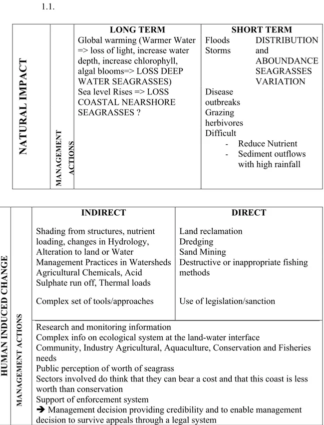
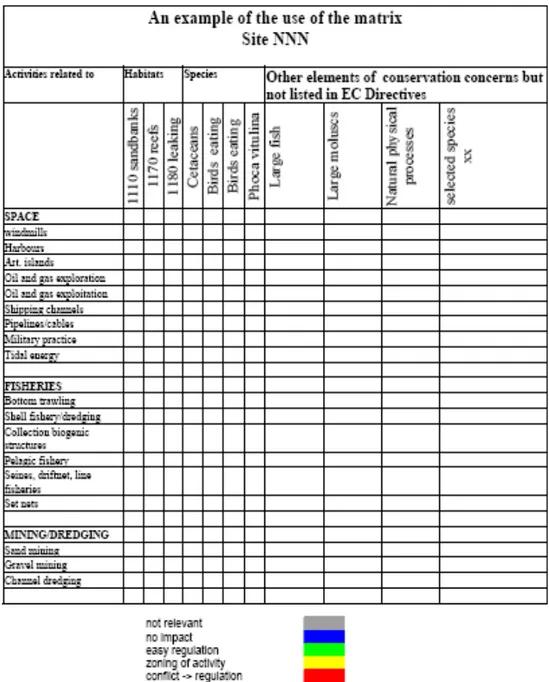
Impacts on Posidonia meadows can be classified following the classification (Short F.T. and Coles R.G., 2001) shown in the table 1.1.
Table 1.1 Impacts on Posidonia meadows
LONG TERM SHORT TERM
Floods Global warming (Warmer Water
=> loss of light, increase water depth, increase chlorophyll, algal blooms=> LOSS DEEP WATER SEAGRASSES)
Storms
Disease outbreaks Sea level Rises => LOSS
COASTAL NEARSHORE SEAGRASSES ? Grazing herbivores DISTRIBUTION and ABOUNDANCE SEAGRASSES VARIATION
N
A
T
U
R
A
L
I
M
P
A
C
T
M A N A G E M E N T A C T IO N S Difficult - Reduce Nutrient - Sediment outflowswith high rainfall
INDIRECT DIRECT
Land reclamation Dredging
Sand Mining Shading from structures, nutrient
loading, changes in Hydrology, Alteration to land or Water
Management Practices in Watersheds Agricultural Chemicals, Acid
Sulphate run off, Thermal loads
Destructive or inappropriate fishing methods
Complex set of tools/approaches Use of legislation/sanction
HUMAN INDUCED CHANGE
M A N A G E M E N T A C T IO N S
Research and monitoring information
Complex info on ecological system at the land-water interface
Community, Industry Agricultural, Aquaculture, Conservation and Fisheries needs
Public perception of worth of seagrass
Sectors involved do think that they can bear a cost and that this coast is less worth than conservation
Support of enforcement system
Management decision providing credibility and to enable management decision to survive appeals through a legal system
18
The tables also give an overview of the possible management actions to be proposed when facing these impacts.
Dealing with natural impacts is difficult and out of the scope of this study, that is focused on identify actions to reduce human induced impacts.
The same provisions of the Habitats Directives as for the terrestrial areas regulate human activities in marine Natura 2000 sites. The provisions of Article 6 of the Habitats Directive apply if the effect of an activity, or a combination of them is likely to be significant.
The Communication from the Commission to the Council and the European Parliament of 24 October 2005, "Thematic strategy on the protection and conservation of the marine environment" is also a relevant policy document in which different pressures to the marine environment are identified.
This communication takes into account the environmental quality of the seas and oceans, giving a summary and a more extensive description of the situation. It highlights that the marine environment is under a series of pressures. These include loss or degradation of biodiversity, changes in the ecosystem structure, loss of habitats, contamination by dangerous substances and nutrients, and the potential consequences of climate change.
Related pressures include commercial fishing, oil and gas exploration, shipping, water-borne and atmospheric deposition of dangerous hazardous substances and nutrients, waste dumping including dumping of dredged contaminated sediments, under water noise pollution and physical degradation of habitats due to dredging and extraction of sand and gravel.
Public education and awareness is the base to improve biodiversity conservation and protection, specifically in maine areas where overexploitation and anthropication are typicals.
19
fisheries that should be take into account, when dealing with public environmental education: “each generation accepts the species composition and stock sizes that they first observe as a natural baseline from which to evaluate changes. This, of course, ignores the fact that this baseline may already represent a disturbed state. The resources then continue to decline, but the next generation resets their baseline to this newly depressed state. The result is a gradual accommodation of the creeping disappearance of resource species and inappropriate reference poits for evaluating economic loss…” (Pauly, 1995, cited in Day, 2001).
Ecosystem approach
The Convention on Biological Diversity defines the Ecosystem Approach as “a strategy for the integrated management of land, water and living resources that promotes conservation and sustainable use in an equitable way” and the ecosystem can be defined as “an interacting complex of living communities and the environment, functioning as a largely self sustaining unit.” It recognizes that humans, with their cultural diversity, are an integral component of ecosystems”.
To provide greater specificity for the purposes of the European Marine Strategy the Ecosystem Approach is described as ‘a comprehensive integrated management of human activities based on best available scientific knowledge about the ecosystem and its dynamics, in order to identify and take action on influences which are critical to the health of the marine ecosystems, thereby achieving sustainable use of ecosystem goods and services and maintenance of ecosystem integrity.’ This description clearly places humans as part of natural ecosystems, and stresses that human activities in these ecosystems must be managed so that they do not compromise ecosystem components that contribute to the structural and functional integrity of the ecosystem.
20
The elaboration of guidelines for the implementation in the marine environment of the so-called Ecosystem Approach has been one of the activities undertaken under the aegis of the European Commission during the preparation of the Environmental Marine Strategy.
In this context, the Ecosystem Approach is embedded in the concept of sustainable development, which requires that the needs of future generations are not compromised by the actions of people today. The Ecosystem Approach puts emphasis on a management regime that maintains the health of the ecosystem alongside appropriate human use of the marine environment, for the benefit of current and future generations.
1.5 Qualitative reasoning modelling
Increasingly, international policies and programs, such as the European Union's Strategy for Sustainable Development (http://ec.europa.eu/sustainable/) and the United Nations' millennium Development Goals (http://www.un.org/millenniumgoals/), are emphasizing the importance of developing consciousness about the factors affecting sustainable development. To support this call, developing qualitative reasoning models of issues relevant to sustainability can be a useful tool; the models are aimed at supporting learning about sustainable development in online interactive environments (http://www.naturnet.org/). Model building involves transforming initially vague and general ideas into clearer and more formally specified representations.
Qualitative Reasoning models can be used as tools for education and decision-making, particularly in domains such as ecology for which numerical data are often unavailable or hard to come by (Petschel-Held, 2005). Furthermore, Qualitative Reasoning models are explicit thereby requiring domain experts to make definite statements
21
modeled. This makes statements falsifiable and discussable, thereby aiding scientific advancement.
Qualitative Reasoning is a formalism that abstracts from real valued numerical data, focusing on system states exhibiting essential distinct behaviour. Garp3 is a fully operational workbench for knowledge capture that provides tools for building Qualitative Reasoning models, simulating them and inspecting the results, using various graphical aids (Bredeweg and Salles, 2009).
Typical Garp3 models involve many different ingredients: Entities represent the structural elements of the system, and agents represent the structural elements exogenous to the system. Configurations indicate the structural relations between entities (and agents). Quantities are associated to entities and agents, representing their dynamic properties. The behaviour of a Quantity is captured by its qualitative Values, symbolic abstractions of the object's continuous properties. The pair <magnitude, derivative> represents the amount and the direction of change of a quantity, respectively. The set of possible values for both magnitudes and derivatives is defined as their quantity space. In Garp3 (Bredeweg et al., 2006, 2009), the quantity space consists of a sequence of points and intervals. For magnitudes, the quantity space is defined by the user, e.g. {zero, low, medium, high}. Derivatives have a default quantity space: {minus, zero, plus}. Landmark Values capture critical points where the system dynamics change.
Important for QR models is the explicit notion of causality between different quantities. Garp3 represents the causal dependencies using direct and indirect influences (Forbus 1984). Direct influences (Influences: I+, I-), called influences for short, can be either positive or negative. If there is a quantity (Q1) with positive magnitude and it puts a positive direct influence on another quantity (Q2), then the derivative of Q2 increases by an amount equal to Q1, and causes the quantity Q2 to increase, while it will have no effect when magnitude
22
is zero. For a negative influence, it is the other way around.
The indirect influences, called proportionalities (Proportionalities: P+, P-), can be either positive or negative. They represent monotonic relations that propagate the effects of processes. If there is a quantity Q2 that is increasing (that is, has a positive derivative) and it is related to another quantity Q3 by a positive proportionality (P+), then the derivative of Q3 takes the same value of the derivative of Q2, and Q3 also increases. If the proportionality is negative (P-), then Q3 will change in the opposite direction.
Other dependences include several types of correspondences (indicating corresponding values) and inequalities {b, ≤, =, ≥, N}.
Correspondences may establish value simultaneity either between specific values in the quantity space (V-correspondence) or between the whole quantity space (Q-correspondence). Inequalities may establish relations either between a quantity and a specific value (of magnitude or derivative), or between two quantities.
A model is built from scenarios representing starting configurations of ingredients, and model fragments that represent conditional knowledge chunks using the above described ingredients.
A simulation is generated by searching for all applicable model fragments for a given scenario, resulting in one or more states. These are then analysed for possible transitions (changing values, changing inequalities, etc) generating successor states. This process continues until no more new states are found.
The output is a state-graph showing all states and their transitions. Each state contains a substantial amount of information and can be inspected using several diagram types. The value history is an important diagram listing the successive magnitudes and derivatives for one or more quantities over the course of a number of states (also known as a ‘behaviour path’).
These modeling elements and their functioning are thoroughly described in Bredeweg and Salles (2009) and Bredeweg et al. (2009).
23
2. METHODOLOGY
2.1 The Studying Site
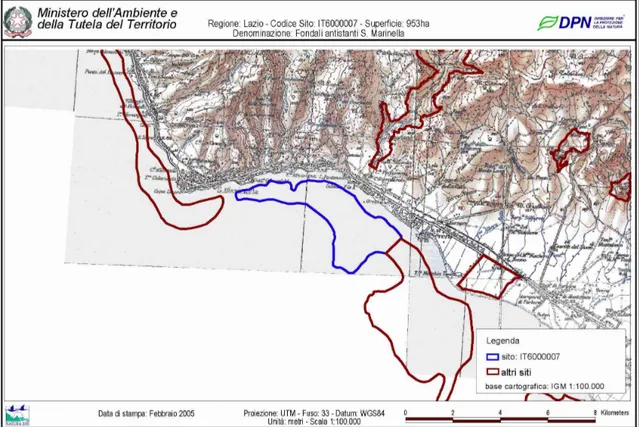
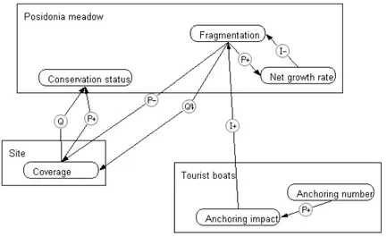
The study was conducted in a P. oceanica meadow within the N2000 SCI named IT6000007 “Fondali antistanti Santa Marinella”.
Figure 2.1. Study area
The site (fig.2.1) borders with two others marine N2000 and it is close to an inland SCI. Its surface is 953,00 sqm and it goes from –3 m to –25 m. It is located in the Mediterranean biogeographic region. 15% of the site is covered by habitat 1120*, Posidonia oceanica meadow. No other relevant information is provided in the official SDF.
24
65 km NW of Rome. It is a tourist place mainly for the inhabitants of Rome and the large population increase occuring in this area every summer has adversely affected the local environment; groundwater pumping has caused salt-water intrusion while uncontrolled waste disposal has created surface hazards and pollution sources. In addition, the inhabitants of S. Marinella are at risk themselves due to the presence of inadequately controlled ephemeral streams, which have caused enormous damage to people and property during past anomalous meteoric events (Chiocchini et al., 1997).
The sea area is between 5 and 25 m deep and it is characterized by rocky bottom, matte, sand and mixed bottom; the typical sediments are medium-fine and medium course sands. Medium-fine sands patches alternated by medium courses sand can be seen in the shallow areas. Medium course sands characterize intermatte patches within the meadow.
There are small areas with transverse sedimentary structures such as “ripple” or small underwater dunes (Ashley, 1990), which wave length range between 0.6 and 1.2 m. They are found on course sediment and they show a reduced idrodinamism.
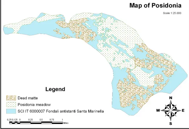
The meadow of Santa Marinella begins north of Cape Linaro and stops at the estearn side of the mouth of Rio Fiume, a small patch can be also found in front of Santa Severa town; it is named “Santa Marinella” as the town where its main surface is found.
The area is characterized by high sea-water turbidity.
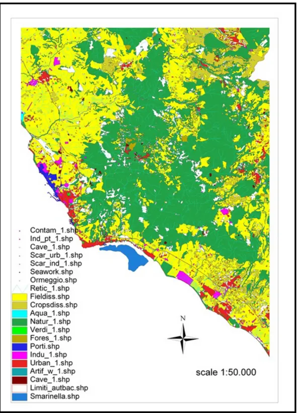
Morphological framework
The terrestrial study region consists of the urban area of S. Marinella, located between the Rome-Civitavecchia Highway (A12) and the Tyrrhenian Coast. This area represents the southern extension of the Tolfa Mountains, forming a cape (Cape Linaro) that ranges in
25
elevation from 85 m asl to sea level. This belt slopes gently towards the Tyrrhenian Sea, particularly between the Rome-Pisa rail line and the coast where the oldest urban part of S. Marinella is located, and could represent a marine erosional surface whose deposits were largely eroded.
The dominant winds during the 2006-2009 (fig.2.2) were S, SSE and NE, according to the data recorded by ISPRA- Rete Mareografica Nazionale (http://www.mareografico.it) with a frequency of about 15%, 12.5% and 12.5% respectively.
Figure 2.2. The dominant winds in the study area during the 2006-2009
The coast is almost low and largerly eroded, from the mouth of Marta river (north of S. Marinella) to Ladispoli (south of S. Marinella) often without sand, with outcrop of clayey river-lake bottom or high coast with small sandy pocket beach. Course sand is found only where sea bottom gentle decrease, as between Cape Linaro and Palo Laziale. This area has rocky sections and inlets with predominantly gravel beaches. With the exception for an old landslide, which occurred in the central part of the study area, the region is presently stable.
26 Sea Bottom types
The continental shelf here is influenced by the solid contribution of the Tevere River and until Ladispoli the bottom is mainly represented by sandy silt, which limit inland is connected with the bioconstruction distribution: where several bioconstructions are spread the sandy silt inland limit is in deepest bottom (eg. near cliffs), where there are inlets the inland limit of sandy silt is on shallow bottom.
The lackness of predominant sandy sediments is an indication of low contribution from inland and of the bioconstruction’s block action SE.
Drift coastal sediments.
Specifically in the area the sediment is mainly (about 80%) characterized by course sediment (>200µ) and a lower percentage (about 20%) of fine sediment (from <2µ to 63µ). The organic substance’s quantity is between 0,17 and 0,54%.
Hydrology
S. Marinella hydrology can be grouped within the larger Tolfa region, which consists of a number of variably sized basins. Locally 14 ephemeral streams, 1–10 km long and trending N–S, flow through S. Marinella before discharging into the Tyrrhenian Sea. These streams form a series of alternating ridges and valleys typical of the coastline, which have an average slope of 6% and a maximum valley width of a few hundred meters. Based on length and watershed size, Castelsecco Creek is the most significant of these ephemeral streams and its headwaters are located 10 km away from S. Marinella at an altitude of 500 m asl. Erosion occurs along these waterways during the “wet season” in winter and along the coast due to waves action.
The main aquifer in the S. Marinella area consists of the Pietraforte turbiditic sandstones, which permeability is due to fracturing of the rock mass. The piezometric surface indicates that aquifer recharge is
27
from the Tolfa Mountains area to the north of S. Marinella. This observation concurs with findings reported by Boni and others (1986) in a hydrogeological study of central Italy. As expected the same piezometric contours follow the morphological trend of the coastline and groundwater flow is orthogonal to the coast.
Locally, the sediments of this area contain very limited and irregular perched water tables which are, for the most part, seasonal. One of these perched water tables was examined in some excavated wells near the coast on the Cape Linaro Belt (Chiocchini et al., 1997); the level in these wells fluctuate significantly, even disappearing (in some cases) during the summer months, showing the seasonality of the water regime.
The water sampled does not show high organic pollution; in addition, ammonium, nitrite and phosphate values are very low. Generally trace metal pollution is not significant, as low to medium levels are found for these elements. This fact is probably related to the absence of high industrialization in the area of S. Marinella (Chiocchini et al., 1997.)
Socio economic framework
The stable residential population of the S. Marinella area is around 16.800 inhabitants, whereas during the summer vacation period (June–September) the population expands, reaching a maximum of 80.000–100.000 in August.
Observing the data from the last available samples of ISTAT (Statistical National Institute), the stable population is increasing in the whole area (Allumiere, Cerveteri, Tolfa, Civitavecchia and Santa Marinella) and mainly in Santa Marinella and Civitavecchia. Probably high frequency trains (every 30 minutes) of Regional Service FR5 of the Province of Roma enhanced the chance of living in this area while working in Rome.
28
Tourism in the area is highly related to the vicinity of the city of Rome; tourism structures are mainly located in Civitavecchia and Santa Marinella; in 2004, the hotels’ bed sites recorded there were 811 and 723 respectively. The solely camping site of the area is located in Civitavecchia and it can host 1000 persons.
Only 4 agritourisms have been recorded in the area and they are mainly located inland, in Cerveteri municipality. Two harbours are in the town of Santa Marinella: Riva di Traiano, located near Civitavecchia, hosting 1.180 boats thanks to 12 quays; Odescalchi, located near the SCI, hosting around 200 boats.
2.2 Biocenosys mapping and site boundaries assessment
The meadow of Santa Marinella has been studied in the past, around 1990 SNAM Progetti has done the first cartography of the meadow which has been published as Diviacco et al. (pers. com. Fresi), around 2000 Conisma processed a new cartography of the area during the monitoring financed by Port Body of Civitavecchia. (Autorità Portuale Civitavecchia and ConiSma – Monitoring of the coastal areas, 2001). The cartography here presented is based on bathy-morphological information on the sea bottom acquired thanks to survey with Single Beam and Side Scan Sonar system (GeoAcoustic 160Dwith a frequency between 100 and 500 kHz) during the first phase of the project “Recupero e reinserimento di Posidonia oceanica” financed by ENEL following the Ministry of Environment prescription for the widen of Torrevaldaliga thermo-electric power plant. The bathimetric survey has been undertaken between 25 m deep and the minimum deepness reacheable with the boat.
The cartographic data has been integrated by underwater video previously acquired and by a sample campaign to characterize coverage, density and phenology of the meadow This processs allowed the identification and description of the biocenosys and sea
29 bottom types at the area.
A GIS map has been edited after having acquired Autocad files in GIS environment. Poligon have been drawn using ArcView 3.2 and saved as shape files.
Quantification of the surface occupied by different biocenosis and sediment types has been calculated.
The legend has been elaborated to show the principal biocenosys found in the area following, wherever possible, the classification of Meisnez (Meisnez et al., 1983) and the habitats typology codified by the Directive 92/43 CEE Annex 1.
In the area 4 different themes corresponding to habitat 1120* have been identified: P. oceanica on rocks, P. oceanica on sand and P. oceanica on matte interspersed with dead matte.
The boundaries of the meadow have been detemined based on the positions of survey sites and the presence of seagrass, coupled with depth contours and other information from SSS samples. The edges have been classified following the 4rth typologies classification (Meisnez and Laurent, 1978; Pergent et al, 1995), which distincts between progressive edge; clear edge; erosive edge or regressive edge. The distinction between edges has been used to assess the quality state of the meadow.
Furthermore this map has been overlapped with the official perimeter of the site (Environmental Ministry database) identified by the Lazio Region and attached to the N2000 SDF. This process allowed the evaluation of the perimeter designation.
All the cartographies produced have been acquired or digitalized and georeferred in the Geographic System European Datum 1950 UTM zone 33 N.
Habitat coverage
30
thanks to ArcGis through the editing of the poligon of living Posidonia within the site’s perimeter. The % of coverage has been calculated as the share of the total SCI surface covered by Posidonia sparse.
2.3 Posidonia meadow conservation status evaluation
Knowing the conservation status of the habitat is a fundamental step to identify and implement good conservation strategy for preserving a site in the long term.
According to the Habitats Directive, the degree of conservation of a habitat comprehends the consideration of the degree of conservation of the structure, the degree of conservation of the functions and the restoration possibility.
This study focused on the degree of conservation of the functions of the Posidonia meadow using the 'best expert judgment'. The methodology used to build the best expert judgement is here described.
Building best expert knowledge
To judge the conservation status of the meadow’s function, a deep knowledge need to be constructed.
The fundamental steps used to build the expert knowledge were:
- Documentation on similar meadows in the same area
- Use of PosiPred- predictive model - Data collection and processing -
Documentation
Existing literature on density and production data for meadows located in similar area have been collected.
31
northern Thyrrenian, as defined by the Italian marine service.
Several data used for the comparing comes from the RIPO project (“Rivisitazione di alcune praterie di Posidonia oceanica lungo le coste delle regioni Liguria, Toscana, Lazio, Basilicata e Puglia e progetto pilota per l’armonizzazione dei relativi dati cartografici esistenti”- Conisma-2002), implemented by Conisma for the Italian Environmental Ministry.
The expected Pergent Class (see next paragraph) has been calculated and per each data, references, locations, deepness, density and expected Pergent class were listed in a table, compared and discussed.
Data Sampling
Data on density were collected 4 times a year; data on production were collected ones a year (on march) during 2006 and 2009.
13 clearings were randomly set in the western part of the meadow, estaern to the Santa Marinella Harbour, within the area in which it was demonstrated the presence of phanerogams (i.e. ‘weeds’) by the SSS samples. This area has been chosen as it can be considered as representative of the whole site, in fact it comprehends all the different bathimetries found in the study meadow and all different typology of sea bottom: living and dead matte, fine and course sands. It has also be chosen because it is easy and cheap to reach with a small boat.
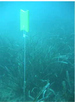
20 sampling stations were chosen in 13 clearings and their positionings were based on an UTM/UPS grid (zone 32T).
Every station point has been marked during the first sampling monitoring with a yellow buoy at to 2 meters from the sea bottom using a stake (fig. 2.3).
32
Figure 2.3. Sampling station
The station points have been marked during the first campaign using a narrow strip attached at the base of the rhizome (fig. 2.4). So they were easily recognizable during the following campaign.
Figure 2.4. Sampling station
Cartesian coordinates of the sampling stations as well as their clearing code, their depth and sea floor cover (S= sand; M= matte; R= rocks) are shown in the table below (tab 2.1).
33
station clearing coordinate deep. (m) Bottom
1 59PNA 740006 4657987 8,5 M 2 59PNB 740026 4657994 8,5 M 3 53PNA 740057 4657961 10 M-S 4 37PNA 740120 4657882 13 M 5 33PNA 739952 4657814 14 M-S 6 33PNB 739939 4657815 13 S-M 7 3PNA 738649 4657877 9,5 M 8 4PNA 738679 4657836 10,5 M-S 9 4PNB 738644 4657838 10,5 S 10 5PNA 738743 4657829 10,5 M 11 5PNB 738756 4657842 10 M 12 6PNA 738777 4657960 8,5 S 13 6PNB 738782 4657998 8 S 14 66PNA 738928 4657960 9 M-S 15 66PNB 738901 4657946 9 M-S 16 13PNA 739268 4658009 9 S 17 67PNA 738523 4657754 12 S 18 69PNA 738575 4657757 11,5 M 19 69PNB 738593 4657769 12 S 20 70PNA 738649 4657775 11 M Table 2.1
Shoots’ density was measured by SCUBA divers after diving from a boat and carrying a square frame and a chalkboard each; they counted the shoots within five square frames (40 x 40 cm) randomly located in the P. oceanica bed around each station point.
Afterwards, the mean value of the five counts was converted to density expressed as shoots x m-2. Two divers have independently assessed the percentage of sea floor that was actually covered by P. oceanica within the circular sampling area. The percentage of the sea floor has been estimated as decimal number (semi-quantitative scale). Then the mean coverage percentage was assumed as the best estimate of sea floor cover, which is also needed for computing relative density (i.e. absolute density x R- sea floor cover, also defined as ‘global density’ by Romero, 1985).
The purpose of these two ways of evaluating density is obviously not the same, as well as their interpretation.
34
Absolute density is more closely related to the health of the bed and to its short-term dynamics; whereas relative (or global) density is more useful in ecosystem scale studies and reflects the outcome of long-term colonization dynamics (Romero, 1985). Both densities have been discussed to describe the meadow and its conservation status. Specifically the relative density has been used to classify the meadow following the Pergent classification (see next paragraph). Absolute density has been used to compare the real data with the expected density following the Posipred model.
The number and biometry of living leaves (leaf shoots) were determined using the method of Giraud (1979). The dry weight (72 h, 60 h) of the oldest leaf from each shoot was also measured.
Foliage growth has been measured following the method of Zieman (1974), and the average leaves’s Primary production per shoots in g year-1 (Pps) has been calculated as (L x N x Dx Bat. correction coeff.).
The rhizomes weight (mg dry wt) has been determined by measuring the weight of a mature (fully expanded) rhizome segment (internode and associated note) after cleaning, rinsing in freshwater and drying for 24 hr at 60°C.
The production is calculated as the mean of the weights of every rhizome’s part for every lepidochronological year (mg dw shoot-1 year-1).
Statistical analysis
Data were analysed by univariate and multivariate techniques. Correlation between variables has been tested through draftsman’s plot of a transformed matrix. Correlation lower then 0.7 have been considered as threashold to keep the variable for successive analysis. Differences between the absolute density, the relative density, the primary production, the rhizomes production and the number of leaves per shoot in the two areas, at various depths and different
35
bottom types were analysed using Non-metric multidimensional scaling (nMDS; Clarke & Warwick 2001). The analysis has been performed on a Euclidean resemblance matrix of the fourth-root transformed data.
Based on the null hypothesis that no differences existed among the different depth values, absolute density and relative density vs depth have been analysed through a one-way ANOVA.
All the analyses were performed using the sofwares: PRIMER6 & PERMANOVA+ (Clarke & Warwick 2001; Anderson et al. 2008), and STATISTICA.
PosiPred prevision model use
To assess the status of Posidonia oceanica meadows a model developed by CoNISMa for the Environmental Ministry has been used. The model runs thanks to a specific software (PosiPred), and its development has been based on an artificial neural web and it allows the estimation of the absolute density and the rhizomes primary production of Posidonia oceanica meadows. PosiPred model can calculate the potential average absolute density and the potential rhizome production foreseen on the base of the morphological sea bottom characteristic in the observation point. The production estimation is much more accurate if the absolute density is known, thus the model have been run twice per each point:
1) Introducing only the predictive variables to calculate the absolute density;
2) Introducing the predictive variables and the absolute density to calculate the rhizomes production.
Specifically, the model is based on a heterogeneus group of predictive variables, from which density and production can be estimated. The variability range of each predictive variable is written in brackets near each of them and is specifically written as (0/1) for binary variable. Also for them it is possible to indicate an intermediate value (eg. 0.5),
36
which can assume the meaning of a fuzzy coding (eg. To be used if the probability of mooring is limited, instead of asserting or excluding it at all).
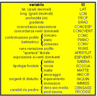
In the figure below the list of the variables to be inserted in the software, is given (fig.2.5).
Figure 2.5. List of the variables inserted in the software
Fundamental indication regarding the single predictive variables and the way of obtaining and expressing numerically them can be found below:
• Latitude in degree and decimal (39.9-44.4) Use degree and degree’s fraction.
• Longitude in degree and decimal (7.5-18.6) Use degree and degree’s fraction.
• Deepness in meter (0.0-35.0)
Can be insert also not full value (es. 12.5). • Gradient (0.0-0.3)
As average slope of the sea bottom between the bathymetric curve closest to the observation point. Its value can be theorethycally between 0 and 1, but it is maximum 0.3 in the present data.
37 • Concordance gradient- aspect (0/1)
Its value is 1 if the direction of the maximum slope of the sea bottom on the observation point is oriented to the fowlwind sector of the site, otherwise 0
• Concordance gradient- dominant wind (0.0-1.0)
If the direction of the maximum slope of the sea bottom its on the same sector of one of the dominant wind, it has a value that represent this wind frequency in a range between 0 and 1, itherwise its value is 0.
• Bathimetric outline conformation: concave, plain or convex (0/1) Considering a line that spin on the observation point, it obviously intersects the upper and lower bathimetric, but in some cases it can intersect the upper or lower bathimetric twice.
In the first case the outline is considered concave- thus the point is on a sea bottom depression-, in the second case the outline is convex – thus the point is on a ridge higher than the closes areas. In the case there is no intersection within half miles of ray, the conformation to be choosen is neutral.
• Runs outline variation (0-4)
It measures the heterogeneity of the bathimetry around the observation point. It is so defined: observing where it falls a point far away a quarter of mile from the observation point in direction of 0°, 45°, 90°, ..., 315°. The value is 0 if the point falls between the bathimetric that comprehend the observation point, the value is +1 if the point falls over or –1 if the point falls below. It is counted the number of value’s changes between following elements of the so obtained’s 8 elements series, including the case of the comparison between the eighth and the first value (the series is develop on an ideal circumference). This number is equal to the same value’s sequence of the series, thus to the number of sectors within the same bathimetric area and around the observation point. In the particular case in which no changes are present, the homogeneity of the