SCUOLA DOTTORALE IN
GEOLOGIA DELL’AMBIENTE E DELLE RISORSE
(SDIGAR)
Ciclo XXIII
RECONSTRUCTION OF BURIAL AND EXHUMATION HISTORY OF THE
APENNINIC-MAGHREBIAN FOLD-AND-THRUST BELT IN EASTERN SICILY
BY MEANS OF INTEGRATED STUDIES OF THERMAL AND
THERMOCHRONOLOGICAL CONSTRAINS
Lea Di Paolo
A.A. 2010/2011
Tutor
Prof.ssa Sveva Corrado
Direttore SDIGAR
Prof. Domenico Cosentino
Correlatori
Dott. Luca Aldega
Dott.ssa Maria Laura Balestrieri
Revisori
Prof. Stefano Mazzoli
Università di Napoli Federico II Dipartimento di Scienze della Terra
Prof. Massimiliano Zattin
Università degli Studi di Padova Dipartimento di Geoscienze
i
ACKNOWLEDGEMENTS
First of all, I would like to express my gratitude to my supervisor, Prof. Sveva Corrado, whose constant guidance and support, enthusiasm and inspiration, enabled me to develop this research project.
I am extremely indebted to Dr. Luca Aldega for his irreplaceable daily help that enhanced every single page of this thesis.
I am grateful to Dr. Sabina Bigi for her encouragement to undertake the PhD doctorate and for the confidence she put in me.
Dr. Maria Laura Balestrieri and Dr. Valerio Olivetti are acknowledged for giving me the possibility to use their thermochronological data and for the discussion on the burial and exhumation history results on the Eastern Sicily fold-and-thrust belt.
I would also like to thank Dr. Roberta Somma and Dr. Rosanna Maniscalco who have contributed significantly to the results presented in Chapter 3 of this thesis and also for their help and hospitality durind the fieldwork.
I am thankful to the Indiana Geological Survey, to Dr. Maria Mastalerz and Dr. Arndt Schimmelmann for the facilities given for conducting the research on organic matter by means of FTIR analysis while in Bloomington and for their kind hospitality.
Thanks are also due to Prof. Stefano Mazzoli and Prof. Massimiliano Zattin who provided stimulating and helpful reviews of my Thesis.
I also want to thank Dr. Sergio Lo Mastro for the time spent on XRD samples scanning. Thanks to all that have orbitated the “Io e la geologia...” PhD study room, Matteo, Chiara, Lilli, Massimetto, Luca, Gianluca, Giorgia… and in particular, Sandro and Danilo for keeping me in a good mood even when it was very difficult and for the time spent to discuss anything but my thesis work.
Thanks also to all the international mix of PhD students and to the Italian brain drain I met in Bloomington, in particular my roommate Dani, Hongji and Aga with whom I had the pleasure to explore the Sunshine State and the Midwest and Ling for the pleasant chats green tea-based.
Thanks to Irene for embarking with me on these last delirious months and to my old roomates, Dalila, Giorgio, Ileana and Naida.
ii
A special thanks goes to Damiano for the lifts to the airport, the English translations, the four-leaf clover he found for me and many other reasons... to him, I would like to dedicate the Chapter 3 of this thesis.
Finally, many thanks to my parents, my sister and my dear friends Fabio, Fabrizio, Lele, Mario and Nicoletta… sui quali posso sempre contare…
iii TABLE OF CONTENTS
ABSTRACT 6
RIASSUNTO 9
CHAPTER 1 - INTRODUCTION 12
1.1. Aims and methodologies 12
1.2. Outline of the thesis 13
1.3. Evolution of this study 14
1.4. Geological setting of Eastern Sicily 16
1.4.1 Previous studies 19
CHAPTER II- METHODS 22
2.1. Optical study of organic matter dispersed in sediments aimed at the analysis of the
thermal evolution of sedimentary basins 22
2.1.1. Generalities: Organic Matter dispersed in sediments and its thermal evolution 22
2.1.2. Thermal maturity parameters used in this Thesis 25
2.1.2.1. Vitrinite Reflectance 25
Sample preparation and analysis 26
2.1.2.2. Fourier transform infra red spectroscopy (FTIR) analysis 27
Concentration of kerogen 29
2.2. XRD study of clay minerals for thermal evolution of sedimentary basins 30 2.2.1. Generalities: clay minerals and their thermal evolution 30
Sample preparation and analysis 33
2.3. Low temperature thermo-chronology for exhumation of sedimentary successions 34
2.3.1. Generalities 34
2.4. Thermo-structural modelling 37
2.5. GIS analysis 38
CHAPTER III - INTERNAL ZONE (PELORITANI MTS.) 40
3.1. Introduction 40
3.2. Geological and structural setting 41
3.3. Geological features of sampled lithostratigraphic units 45
3.4.1. Organic matter data 46
3.4.1.1. Stilo Capo d‟Orlando Formation 46
iv
3.4.1.3. Serravallian-Messinian siliciclastic deposits 50
3.4.2. Clay mineralogy data 50
3.4.2.1. Stilo Capo d‟Orlando Formation 50
3.4.2.2. Antisicilide Unit 51
3.4.2.3. Serravallian-Messinian siliciclastic deposits 52
3.4.3. Structural data 52
3.4.3.1. Stilo Capo d‟Orlando Formation 52
3.4.3.2. Antisicilide Unit 54
3.4.3.3. Serravallian-Messinian siliciclastic deposits 54
3.5. Discussion 55
3.5.1. Isopach and paleoisopach map reconstruction of the Stilo-Capo d‟Orlando Basin 55 3.5.2. Reconstruction of the paleogeothermal gradient during Oligocene Miocene time
56 3.5.3. Burial and thermal history of the Stilo Capo d‟Orlando depocentre 58 3.5.4. Sedimentary vs. tectonic burial of the Peloritani Mts. northern sector 59
3.6. Conclusion 64
CHAPTER IV - EXTERNAL ZONE (MT. JUDICA UNIT) 65
4.1. Introduction 65
4.2. Geological setting 67
4.3. Results 73
4.3.1 - FTIR on organic matter 73
4.3.2. XRD on clay minerals 76
4.4. Discussion 79
4.4.1. Thermal evolution of Mt. Judica succession 79
4.4.1a. Extracting information on thermal maturity from FTIR spectra 79
4.4.1b. Thermal modelling 81
4.4.2. Along-strike variations of the Gela nappe front 84
4.4.3. Application of critical taper analysis to the eastern Sicily fold-and-thrust belt 87
4.5. Conclusion 91
CHAPTER V - EARLY FOREDEEP DEPOSITS (“NUMIDIAN FLYSCH”) 92
5.1. Introduction: Geological setting of the Numidian Flysch Basin in the Mediterranean
area 92
5.2. Geological and structural setting of the Numidian Flysch in Eastern Sicily 93
5.3. Results 99
5.3.1. Maragone Unit 99
5.3.2. Nicosia Unit 102
5.3.3. Mt. Salici Unit 105
v
5.4. Discussion 105
Thermal interpretation of the tectono-stratigraphic units 105
5.4.1. Maragone Unit 105
5.4.2. Nicosia Unit 106
5.4.3. Mt. Salici Unit 106
5.5. Conclusion 106
CHAPTER VI - BURIAL AND EXHUMATION ALONG THE OROGENIC
TRANSECT 108
REFERENCES CITED 121
6 ABSTRACT
The reconstruction of burial and exhumation history of sedimentary rocks can provide, when linked with the structural and stratigraphic records, important time-temperature constraints to the thrust belt dynamics. The purpose of this study has been to decipher the maximum paleo-temperatures and the exhumation rates of the sedimentary successions constituting the Eastern Sicily fold-and-thrust belt through a multidisciplinary approach based on the integration of different thermal and thermo-chronological methodologies.
In particular, three sectors of the Eastern Sicily fold-and-thrust belt were investigated: the Internal Zone of the Peloritani Mts., the frontal part of the thrust belt in the Mt. Judica area and the outcropping area of the Numidian Flysch.
In the Peloritani Mts., the integration of Vitrinite reflectance and mixed-layered clay minerals with published apatite fission-track and (U-Th)/He ages allowed to reconstruct the paleo-geothermal gradient of the Stilo-Capo d‟Orlando basin in Oligocene-Miocene times, to constrain its burial evolution and discriminate between areas where it has been affected by sedimentary and/or tectonic load. In the southern area of the basin, organic and inorganic thermal parameters increase as function of depth suggesting that their evolution is ruled by sedimentary burial. They recorded a decrease in paleo-geothermal gradient values which marked the evolution of the basin from a fore-arc to a thrust-top setting during the convergence-collision process between the Calabria-Peloritani Arc and the African plate. Differently, in the northern edge of the basin, high vitrinite reflectance values (0.46-0.58%) indicate that the thermal evolution of this area was controlled by tectonic burial related to a late Langhian-early Serravallian out-of-sequence thrusting. The tectonic overburden has been totally removed by extensional tectonics and/or erosion since Late Miocene. The short time span at maximum temperature (<2 Ma) elapsing between thrust stack emplacement and the beginning of its removal have allowed only vitrinite reflectance and thermo-chronological indicators to record this compressive reactivation.
In the Mt. Judica area, the integration of X-ray diffraction (XRD) data concerning the illite content in mixed layer illite-smectite with data derived from Fourier Transform Infrared spectroscopy (FTIR) on H-rich organic matter allowed to constrain the
burial-7
exhumation path of the Mt. Judica sedimentary succession cropping out in tectonic window in Eastern Sicily.
Thermal constraints showed that the Mt. Judica succession experienced paleo-temperatures in the range of 100-130 °C in late diagenetic conditions and early mature stage of hydrocarbon generation with a general depth-dependent thermal maturity feature. Specifically, the illite content in mixed layer I-S increases from 50 to 76% and FTIR-derived indexes suggest a thermal maturity equivalent to VRo values of at least 0.5-0.7%.
As a whole, the Mt. Judica succession experienced maximum tectonic burial (ranging between 2.4 and 3.2 km) during the Middle Miocene as a result of the emplacement of the Allochthonous Units atop it. The subsequent breaching phase characterized by up-thrust geometries, and erosion during Pliocene times ruled out the Mt. Judica exhumation. This last tectonic phase did not overprint thermal maturity because the extent of overthrusting was negligible when compared with the magnitude of vertical movements. Restoration of balanced cross-sections revealed an increase of shortening from the salient to the Mt. Judica recess with values from 12.3 to 23.9 km, consistent with the increase of tectonic thickening of the fold-and-thrust belt. Integration of maximum burial and shortening values along the strike of the Sicilian fold-and-thrust belt allowed to reconstruct the wedge paleo-geometry in the Mt. Judica recess area, to investigate the along-strike variations of the tectonic overburden, and to discuss the geodynamic causes of these changes. These results were compared with theoretical models of wedge dynamics.
For the Numidian Flysch thrust stack an increasing level of diagenesis from the uppermost to the lowermost tectono-stratigraphic units has been observed. From the top to the bottom of the tectonic pile, the Nicosia Unit showed the lowest % I values in I-S mixed layers in the range of 20-50% and vitrinite reflectance data between 0.36-0.42% in the immature stages of hydrocarbon generation. The Mt. Salici Unit displayed random ordered mixed layers I-S with an illite content of 50-55%. These data correlated to slightly higher levels of diagenesis than those recorded in the Nicosia Unit, suggesting that sedimentary burial is the main factor affecting the thermal maturity of both units. The lowermost of the Numidian tectonic pile (Maragone Unit) revealed mixed-layered ordered structures with % of I in I-S between 66 and 79% indicating the highest levels of thermal maturity for the Numidian Flysch.
8
The integration of organic and inorganic thermal parameters with thermo-chronological data performed for my PhD project on the main outcropping tectono-stratigraphic Units in Eastern Sicily, contributed to the reconstruction of the burial and exhumation history of the Peloritani Mts. and the Apenninic-Maghrebian fold-and-thrust belt between the Nebrodi Mts. and the Hyblean Foreland.
9 RIASSUNTO
La ricostruzione dei carichi tettonico/sedimentari e dell‟esumazione delle successioni sedimentarie che costituiscono le catene orogeniche, integrata con dati stratigrafico-strutturali, può fornire importanti vincoli termici e temporali alla dinamica delle catene orogeniche. L'obiettivo di questa Tesi è stato quello di ricostruire l‟evoluzione termica e termo-cronologica delle successioni sedimentarie, costituenti le unità della catena Appenninico-Maghrebide affioranti in Sicilia orientale, per porre nuovi vincoli quantitativi alla definizione di un modello di evoluzione geodinamica neogenico-quaternaria dell‟orogene.
E‟ stato utilizzato un approccio multidisciplinare basato sull‟integrazione di differenti metodologie di analisi termica e termocronologica tipiche dell‟Analisi di Bacino. Lo studio ottico e all‟infrarosso della materia organica dispersa nei sedimenti e lo studio ai raggi x dei minerali delle argille, sostanziato dall‟analisi delle tracce di fissione in apatite, ha permesso di quantificare i massimi carichi sedimentari e/o tettonici subiti dalle successioni sedimentarie studiate. L‟analisi delle tracce di fissione in apatite inoltre, ha permesso di definire i tassi e l‟entità dell‟esumazione. I dati termici e termocronologici ottenuti sono stati utilizzati per calibrare modelli termici e di seppellimento monodimensionale attraverso l‟utilizzo del software Basin mod 1D e per creare un database in QuantumGIS software che ha consentito la realizzazione di carte tematiche. Le informazioni derivanti dai diversi settori sono state integrate, insieme con ricostruzioni già esistenti per altre porzioni della catena (p.e., prisma di accrezione sicilide) per ricostruire la storia esumativa dell‟intero sistema orogenico affiorante in Sicilia orientale.
In particolare sono stati indagati tre settori della catena orogenica: la Zona Interna dei Monti Peloritani, il fronte orogenico nell‟area di Monte Judica e l‟area di affioramento del Flysch Numidico.
Nei Monti Peloritani, l‟integrazione della riflettanza della vitrinite con gli strati misti dei minerali delle argille e con dati pubblicati di tracce di fissione in apatite ed età (U-Th)/He hanno permesso di ricostruire il gradiente paleogeotermico del bacino di Stilo-Capo d‟Orlando nell‟Oligo-Miocene e di vincolarne la storia di seppellimento, distinguendo tra aree affette da carico tettonico e/o sedimentario. Nell‟area meridionale del bacino, i parametri termici organici ed inorganici aumentano in funzione della profondità suggerendo un‟evoluzione termica e di seppellimento regolata dal carico sedimentario. E‟ stata osservata una diminuzione dei valori di gradiente paleogeotermico che marca l‟evoluzione del bacino di Stilo-Capo d‟Orlando da un assetto di fore-arc nell‟Oligocene ad uno di thrust-top nel Miocene in seguito alla collisione tra l‟arco Calabro-Peloritano e la placca Africana.
10
Differentemente, nel settore più settentrionale del bacino, alti valori di riflettanza della vitrinite (0.46-0.58%) indicano che l‟evoluzione termica di questa area è stata regolata dalla messa in posto di un carico tettonico relativo ad una riattivazione in fuori sequenza delle zone più interne avvenuta tra il Langhiano superiore e il Serravalliano inferiore.
Il carico tettonico è stato velocemente rimosso, a partire dal Miocene Superiore, per erosione e per tettonica estensionale che ha accomodato la deposizione delle marne serravalliane-messiniane sui blocchi del complesso metamorfico ribassati.
I minerali delle argille non hanno registrato la riattivazione in compressione dei settori interni della catena a causa del breve intervallo di tempo alle massime temperature (<2Ma), intercorso tra la messa in posto del carico tettonico e l‟inizio della sua rimozione.
Nell‟area di Monte Judica al fronte della catena orogenica, l‟integrazione di dati derivanti dall‟analisi quantitativa in diffrazione ai raggi X riguardanti il contenuto di illite nell‟interstratificato misto illite-smectite con dati derivanti dalla Spettroscopia all‟Infrarosso in Trasformata di Fourier (FTIR) su materia organica ricca in idrogeno, ha permesso di vincolare la storia di seppellimento ed esumazione della successione sedimentaria di Monte Judica affiorante in finestra tettonica.
I vincoli termici hanno permesso di determinare per la successione di Monte Judica paleotemperature massime raggiunte tra 100 e 130 °C corrispondenti a condizioni diagenetiche tardive ed ad un primo stadio maturo di generazione degli idrocarburi con un generale aumento della maturità termica in funzione della profondità. Nel dettaglio, il contenuto di illite nell‟interstratificato misto I-S aumenta dal 50 al 76% e gli indici di maturità derivati dall‟ FTIR suggeriscono una maturità termica equivalente a valori di almeno 0.5-0.7% di VRo. In definitiva, la successione di Monte Judica ha subito il
seppellimento tettonico massimo (tra 2.4 e 3.2 km) nel Miocene Medio a causa dell‟accavallamento dell‟Unità Alloctona Superiore (complesso Sicilide e Flysch Numidico).
La successiva fase deformativa nel Pliocene, caratterizzata da sovrascorrimenti ad alto angolo ed erosione, ha regolato l‟esumazione dell‟Unità di Monte Judica non influenzando la storia termica. La ricostruzione delle sezioni bilanciate ha mostrato un aumento del raccorciamento dal saliente di Gela al recesso di Monte Judica con valori da 12.3 a 23.9 km, in accordo con l‟aumento dell‟ispessimento tettonico della catena a pieghe e sovrascorrimenti. L‟integrazione del massimo seppellimento con i valori di raccorciamento calcolati lungo lo strike della catena a pieghe e sovrascorrimenti in Sicilia
11
orientale, ha permesso di ricostruire la paleogeometria del cuneo orogenico nell‟area di recesso, di investigare le variazioni del carico tettonico lungo lo strike della catena e di discuterne le cause geodinamiche.
Per l‟impilameno tettonico del Flysch Numidico è stato osservato un aumento della maturità termica dalle Unità tettono-stratigrafiche sommitali a quelle basali. Dal top alla base della pila tettonica, l‟Unità di Nicosia ha mostrato i valori più bassi di percentuale di illite nell‟interstratificato misto I-S (tra il 20 e il 50%) e di riflettanza della vitrinite (tra 0.36 e 0.42%) corrispondenti allo stadio immaturo di generazione degli idrocarburi. L‟Unità di Mt. Salici ha rivelato un contenuto di I nell‟interstratificato misto I-S di 50-55%. Questi dati sono stati correlati con livelli diagenetici leggermente più alti rispetto all‟Unità di Nicosia suggerendo che il fattore principale che ha influito sulla maturità termica di entrambe le unità è stato il carico sedimentario. L‟Unità tettonica strutturalmente più bassa (l‟Unità di Maragone) ha mostrato una percentuale di illite nell‟interstratificato misto I-S tra il 66 e il 79% indicando i livelli più alti di maturità per il Flysch Numidico.
L‟integrazione di parametri termici organici ed inorganici con dati termocronologici prodotti durante il dottorato di ricerca sulle principali Unità tettono-stratigrafiche affioranti in Sicilia orientale, hanno contribuito alla ricostruzione della storia di seppellimento ed esumazione dei Monti Peloritani e della catena a pieghe e sovrascorrimenti Appenninico-Magrebide tra i Monti Nebrodi e l‟avampaese Ibleo.
12
CHAPTER 1 - INTRODUCTION
1.1. Aims and methodologies
Characterizing the timing and magnitude of vertical motions of rocks within thrust belts is critical for understanding their development and evolution. Although structural and metamorphic studies have begun to address these fundamental issues, remarkably little is known of the timing, duration, and rates of thrust belt construction, thickening, and un-roofing. Deciphering thermal-burial histories and exhumation rates of sedimentary rocks can provide, when linked with the structural record, critical time-temperature constraints necessary for a more complete understanding of thrust belt dynamics.
The aim of this Thesis is the reconstruction of the burial and exhumation history of the tectono-stratigraphic Units and syn-orogenic sediments outcropping in Eastern Sicily (Fig. 1.1). This region is particularly suitable for these kinds of studies because it is a well-known portion of the orogen from a stratigraphic and structural point of view and it is also peculiar for the presence of the boundary between the Internal and External Zones constituting the orogen. In addition, the bibliography in this sense is very poor.
A multidisciplinary approach based on the integration of different thermal and thermo-chronological methodologies was used to achieve this aim. The used methods are typical of Basin Analysis, developed for oil exploration and then applied to geodynamic issues.
The optical and infra-red study of the organic matter dispersed in sediments and the X-ray diffraction study of clay minerals, substantiated by apatite fission track analyses, allowed the quantification of maximum sedimentary and/or tectonic loads the studied successions underwent. Furthermore, the apatite fission track analysis provided the definition of the exhumation timing, rates and magnitudes of exposed successions.
Basin Mod 1D software applications, that jointly elaborate data from stratigraphic-structural and paleo-thermometric databases, allowed the creation of mono-dimensional thermo-burial models, while QuantumGis and ArcGIS softwares allowed the creation of database of geological and paleo-geothermal data obtained from literature, fieldwork and laboratory and the construction of thematic maps.
13
Figure 1.1 - Tectonic sketch map of the Mediterranean area. Rectangle shows the studied area.
1.2. Outline of the thesis
Chapter 1 is the present general introduction to aims, methodologies and evolution (Fig. 1.2) of this research. In addition, it offers a description of the geological setting and previous thermal and thermo-chronological studies of the investigated area.
Chapter 2 introduces theoretical aspects and analytical procedures of the applied methodologies and a description of the used software.
Chapter 3 focuses on the thermal and structural evolution of the Internal zones of the Eastern Sicily fold-and-thrust belt (Peloritani Mts.).
Chapter 4 treats the thermal and structural evolution of the Mt. Judica Unit at the front of the orogen.
Chapter 5 presents the thermal results of the Early foredeep deposits (Numidian Flysch). In the chapter 6, which represents a key part of this thesis, the results coming from the different studied areas are integrated with previous studies to reconstruct the burial and exhumation history along the eastern Sicily transect.
14
1.3. Evolution of this study
The first few months were spent reviewing the literature of the sedimentary successions outcropping in the Eastern Sicily. The research was focused on the study of the most recent bibliography of the analytical Tecniques and theory on thermal evolution of sedimentary basins used and on the existing geological mapping, geological-structural, stratigraphic-sedimentological, biostratigraphical and petrographic data of Eastern Sicily.
Following a critical review of bibliographic data, three key sectors for structural investigation and sampling for thermal and thermo-chronological analysis were identified. Samples for organic matter optical analysis and clay mineralogy were collected in the field and prepared for lab analysis. The Vitrinite Reflectance data, were performed and processed, evaluating the interpretative problems related to alteration and rearrangement of fragments, and correlated with data derived from the analysis of clay mineralogy and apatite fission tracks.
In the first half of the second year, the reconstruction of the thermal evolution of the sedimentary successions cropping out in the Peloritani Mts. was performed and a geological interpretation was proposed.
The second half was spent both on the studies of the Mt. Judica Unit and Numidian Flysch, and on a bibliographic research about further methods of organic matter thermal analysis. Several field geological campaign were carried on to collect samples and for structural analysis.
The first three months of the third year were spent at the Indiana Geological Survey and Department of Geology of the Indiana University, Bloomington, USA, as a visiting scholar. Collected samples of the Mt. Judica Unit were analyzed with FTIR instrumentation in collaboration with Dr. M. Mastalerz and Dr. A. Schimmelmann.
The rest of the time was spent in unravelling the thermal evolution of the Mt. Judica Unit and of the Numidian Flysch and to construct a model of geodynamic evolution of the orogen.
Throughout the duration of this study, poster and oral presentations were given at national and international conferences:
1. Meeting in Memory of Angelo di Grande and Mario Grasso, Catania, June 2008; 2. EAGE Conference & Exhibition, Rome, June 2008;
3. Geoitalia 2009, VII Forum italiano di Scienze della Terra, Rimini, September 2009; 4. EAGE Conference & Exhibition, Barcellona, June 2010.
15
Figure 1.2 - Diagram showing the study evolution and thesis organization.
MAIN PHASES OF THE RESEARCH
Focusing on aims and methodologies
Critical review of literature and existing data on regional geology Bibliographic research on methodologies and analytical techniques
chapters I and II Study areas Peloritani Mts. (Internal Zone) chapter III Mt. Judica Unit (External Zone) chapter IV Numidian Flysch (External Zone) chapter V
Interpretation and correlation
Thermo-structural modeling (Basin Mod 1D software)
Database and thematic map creation (QuantumGIS and ArcGIS softwares)
Evaluation of exhumation rate, tectonic and/or sedimentary loads experienced in the past Reconstruction of the burial and exhumation history along the orogenic transect
Geologic and geodynamic interpretation of the studied area
chapter III-VI
Conclusion chapter VII
Sample preparation
85 samples for the optical analysis of organic matter dispersed in sediments and measurement of Ro% (Department of Geological Sciences, University of "Roma Tre")
18 samples for FTIR analysis of organic matter (Indiana Geological Survey and Department of Geology, Indiana University, Bloomington, USA).
75 samples for XRD analysis of clays (Department of Geological Sciences, University of "Roma Tre")
Field work Lab work
Sampling for organic matter and mineralogical analysis.
Stratigraphic and structural contextualization sampling. DATE SAMPLES 12-13/01/2008 → SI 81 - SI 88 4-8/02/2008 → SI 89 – SI 103 7-11/07/2008 → SI 104 - SI 127 16-20/01/2009 → SI 128 - SI 140 9-11/02/2009 → SI 141 - SI 142 26-31/05/2009 → SI 143 - SI 175
16
1.4. Geological setting of Eastern Sicily
In the western Mediterranean area (Fig. 1.3), the convergence and continental collision between the European, Iberian, African and Adria plates have been leading since the Late Cretaceous to the formation of thousands of kilometers long arcuate Alpine orogen (Dewey et al., 1989; Faccenna et al., 2001). Particularly, the western Peri-Mediterranean Alpine orogen is classically subdivided into two main structural zones indicated as Internal and External Zones (Fig. 1.3; Martín-Algarra et al., 2000; Vera, 2004; Perrone et al., 2006 and references therein). The Internal Zones, cropping out in the hinterland of the Betic Cordillera, Rif, Kabylies, Northern Apennines, and in the Calabria-Peloritani Arc, consist of nappes deriving from the deformation of original paleo-geographic domains belonging to the European plate paleo-margin (Bouillin, 1984) or, according to recent reconstructions, to a small continental crust block -the Mesomediterannean Block- (Martín-Algarra and Vera, 2004). Differently, the External Zones, exposed on the outer portions of the Betic Cordillera, African and Sicilian Maghrebids, Northern and Southern Apennines, are made up of tectono-stratigraphic units deriving from the deformation of paleo-geographic domains belonging to the south Iberian, African and western Adria paleo-margins (Martín-Algarra et al., 2000). Jurassic to Miocene clastic deposits, sedimented in the original Flysch Basin (Guerrera et al., 2005), form the tectono-stratigraphic units interposed between the Internal and External Zones (Fig. 1.3).
Figure 1.3 - Tectonic sketch map of the western Mediterranean region. Acronyms - ABPB: Algero-Balearic-Provençal Basin; Ap: Apulia Plateau; BC: Betic Cordillera; BI: Balearic Islands; Co: Corsica; Hy: Hyblean Plateau; NA: Northern Apennines; RM: Rifian Maghrebids; Sa: Sardinia; SA: Southern Apennines; SM: Sicilian Maghrebids; TB: Tyrrhenian Basin; TM: Tellian Maghrebids.
17
In Eastern Sicily the thrust belt is formed by both the two main structural zones: the Internal Zone to the north and the External Zone to the south.
The Internal Zone consists of south-verging thin crystalline nappes and Late Oligocene-Messinian syn-orogenic deposits of the Peloritani Mts. (Kabilian-Peloritan-Calabrian Units sensu Lentini et al. 1996; Fig. 1.4).
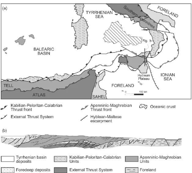
Figure 1.4 – (a) Tectonic map of Sicily, Tyrrhenian Sea, and adjacent areas; (b) Schematic regional cross section across Eastern Sicily reworked and modified after Bianchi et al. 1996.
The External Zone is made up of two main tectono-stratigraphic domains: the Apenninic-Maghrebian belt and the External Thrust System (Fig. 1.4).
The crystalline nappes of the Kabilian-Peloritan-Calabrian belt still widely preserve the Variscan signature (De Gregorio et al., 2003; Somma et al., 2005). Some nappes record Alpine metamorphism (Atzori et al., 1994), followed by substantial exhumation prior to
18
their final emplacement atop the Apenninic-Maghrebian Units, as indicated by zircon and apatite fission-track data (Thomson, 1994). This early exhumation is controlled by synorogenic extension (Cutrupia and Russo, 2005; Somma et al., 2005), predating the overthrusting onto the Apenninic-Maghrebian belt in Early Miocene times (Amodio-Morelli et al., 1976).
The Apenninic-Maghrebian belt is made up of imbricate sheets of Mesozoic-Tertiary rocks (Lentini et al., 1995). Its structurally highest tectono-stratigraphic units, well exposed in the Nebrodi Mts., are represented by the remnants of the Neotethyan accretionary wedge, made up of part of the Sicilide Complex (Mt. Soro, Troina, and far-travelled Sicilide Units) consisting of a Late Cretaceous to Early Miocene pelagic succession and by the Oligocene-Langhian foredeep deposits of the Numidian Flysch (Carbone et al., 1990; Lentini et al. 2000).
Tectonically beneath these units, the more external Imerese-Sicano Unit is present. It crops out in the tectonic window of Mt. Judica area at the front of the Eastern Sicily fold-and-thrust belt. These two Allochthonous Units form a thin-skinned thrust system that rest on a more External Thrust System (ETS) (Fig. 1.4). This system derived from the imbrication of a thick carbonate platform sequence with interleaved marls and mafic volcanic levels (Bianchi et al., 1989; Billi et al., 2006) detached from the flexure continental sectors of the Africa foreland (Lentini et al., 1996, Fig. 1.4).
The present-day structural setting of the orogen is the result of a poliphasic deformation started since Early Miocene times with the emplacement of the allochtonous Units (Numidian Flysch, Sicilide Complex and the Imerese-Sicano Unit) onto the Hyblean foreland through low angle regional thrusts (Bello et al., 2000) and with the overthrusting of the metamorphic massif of the Peloritani Mts. onto the innermost sedimentary units of the Eastern Sicily fold-and-thrust belt (Amodio-Morelli et al. 1976).
During Upper Miocene–early Pliocene times the development of the External Thrust System strongly modified the geometric relationships of the Allochthonous Units, producing the internal stacking of the Mt. Judica succession (Bello et al. 2000) and break-back, out of sequence, propagation of back-thrusts in central-north Sicily (Carbone et al. 1990; Grasso et al. 1995).
19
1.4.1 Previous studies
In recent years there have been several contribution aiming at defining maximum burial depths and exhumation rates of the sedimentary successions and tectonic units forming the Eastern Sicily fold-and-thrust belt.
Thomson (1994) and Olivetti et al. (2010), studying the Internal Zone of the Eastern Sicily fold-and-thrust belt by means of apatite fission-track (AFT) and (U-Th)/He analyses, have been reconstructed in the crystalline rocks of the Peloritani Mts. two main cooling phases since Oligocene times.
Thomson (1994) ascribed the older exhumation phase of the Peloritani Mts. between 35 and 15 Ma and Olivetti et al. (2010), recognized a second exhumation phase (AFT ages<15 Ma) with a rate of 0.3 mm/yr calculated from the difference between young AFT and Th)/He ages (AFT ages range between 29.0±5.5 Ma and 5.5±0.9 Ma while (U-Th)/He ages vary from 19.4 Ma to 3.3 Ma) post-dating the Stilo-Capo d‟Orlando deposition.
Several Authors have studied the External Zone. The thermal state of the Mt. Judica Unit was investigated by Roure et al. (1990) and their burial evaluation, about 3 km, was confirmed by Aldega et al. (2007), although Larroque et al. (1996) and Dewever et al. (2006), observed homogenization temperatures of fluid inclusions (235±10 °C in the calcite veins for the deep sole thrust) that suggest deeper burial and/or hot fluid circulation.
Aldega et al. (2007) proposed a first thermal quantitative characterization for most of the units of the eastern sicily fold-and-thrust belt on the basis of optical organic matter maturity and X-ray diffraction clay-mineralogy data, observing a general trend of decreasing thermal maturity of sediments moving from hinterland to foreland and from older to younger stratigraphic units (Fig. 1.5).
Corrado et al. (2009) providing new thermal and thermo-chronological constraints, recognize a warmer core made up of the Mt. Soro and Troina Units and two colder rims constituted by the far-travelled Sicilide and Antisicilide Units. The former is characterized by vitrinite reflectance values ranging between 0.6 and 0.96% and illite content in mixed layer I-S between 60 and 85%, the second by vitrinite reflectance ranging between 0.41 and 0.56% and illite content in mixed layer I-S between 25 and 50%. AFT data indicate that fission tracks were partially to totally annealed during wedge accretion and that the subsequent exhumation occurred mainly in Burdigalian times
(17.7-20
20.2 Ma). AFT data from Antisicilide Unit indicate low levels of thermal maturity in early diagenetic conditions because of no annealing of tracks. The Mt. Soro and Troina Units were involved into trench development before Early Miocene times and acquired a late diagenetic signature due to thrust-stacking at deep levels whereas the far-travelled Sicilide and Antisicilide Units kept their early diagenetic signature at shallower or outer structural levels of the accretionary wedge and were remobilized since late Burdigalian-Langhian times by gravity-driven processes (Fig. 1.6).
Barbera et al. (2009), using XRD clay mineralogy analysis, chemical composition and multivariate analysis on shales belonging to several tectono-stratigraphic units of the Apenninic-Maghrebian confirmed the diagenetic conditions of the Sicilide accretionary wedge. In particular the diagenetic grade increases from the south-west, where the external Numidian Flysch (NS) and the VS underwent low diagenetic conditions, to the north-east where the originally inner and structurally highest units (CSS; Monte Soro and Upper Scagliose shales) reached high-grade diagenetic stages in agreement with Aldega (2007) and Corrado (2009).
Figure 1.5 – Schematic geological cross section between Troina village and Mt. Judica with main thermal data from Aldega et al. (2007).
21
Figure 1.6 – Schematic evolution of burial-exhumation of the accretionary wedge of the Apenninic-Maghrebian orogen in Eastern Sicily in Aquitanian-Langhian times from Corrado et al. (2009).
22
CHAPTER II- METHODS
Methods described in this section are those directly used to derive pieces of information on thermal evolution of studied sedimentary successions or adopted to elaborate new and pre-existing data for geological interpretation.
2.1. Optical study of organic matter dispersed in sediments aimed at the analysis of the thermal evolution of sedimentary basins
2.1.1. Generalities: Organic Matter dispersed in sediments and its thermal evolution
The organic matter (OM) dispersed in sediments is composed of a mixture of organic compounds of various origin and composition. Aquatic organisms contribute mainly proteins, lipids and carbohydrates; higher plants contribute resins, waxes, lignins and carbohydrates in the form of cellulose (Barnes et al., 1990).
In the starting phases of sediment burial, the OM sustains irreversible physical and chemical variations that are extremely sensitive to temperature changes concerning the re-organization of carbon-hydrogen bonds. These transformations will produce an organic macromolecule called kerogen that progressively will convert into hydrocarbons with increasing burial and temperature.
Kerogens are commonly characterized by the use of bulk parameters, such as the H/C and O/C atomic ratios, obtained from elemental analyses (Fig. 2.1).
On the basis of these ratios, four types of kerogen have been defined which appear to follow distinct diagenetic pathways. This division of kerogen in four types has been supported by another independent scheme of classification using transmitted-light microscopy, so that kerogen types are defined by the morphologies of the kerogen particles called macerals.
Type I kerogen has high initial H/C and low O/C ratios. The source material is mainly algal, or a combination of algal lipids and waxes from higher plants. It forms part of the liptinite macerals in coal (Fig. 2.2).
23
Type II kerogen has intermediate initial H/C and O/C ratios, and larger contributions by aromatic and carboxylic acid groups than the type I kerogens. Ester bonds are abundant, as are medium-length aliphatic hydrocarbon chains and naphthenic rings. Both algal and higher plant sources appear to contribute to type II kerogens (liptinite macerals).
Figure 2.1 - Van Krevelen diagram showing maturation pathways for Types I to IV kerogen as traced by changes in atomic H/C and O/C ratios. The progressively darker shaded areas approximately represent diagenesis, catagenesis, and metagenesis stages, respectively (from http://www.falw.vu/~rondeel/grondstof/oil/oil-total-web.html#_Toc531067567).
Type III kerogen has an initial H/C ratio less than 1, an initial O/C ratio of 0.2 to 0.3, and is derived dominantly from terrestrial plants. It consists mainly of aromatic groups formed from lignins and humic compounds, and represents the huminite/vitrinite fractions of coal petrography. Oxygen is present as carboxylic acids, ketones and ethers rather than in ester bonds.
Type IV kerogen has the H/C ratio less than 0.5 and contains mostly decomposed organic matter and highly oxidized material of various origins and represents the inertinite group (Fig. 2.2).
With increasing maturity, kerogen looses first preferentially O to produce CO2 and H2O, then H to produce hydrocarbons. Changes in the molecular structure have effect in the petrographic appearance of the vitrinite macerals with a strong increase of their capacity to reflect light.
24
Reflectance of vitrinite is one of the most commonly used indicators of thermal maturity and is correlated to the stages of hydrocarbon generation and other thermal parameters in sedimentary environments (Hunt, 1986; Scotti, 2003; Fig. 2.3).
Thus, it is one of the most widely used parameter to calibrate basin modelling (Dow, 1977; Mukhopadhyay, 1994). The method relies on the presence of the huminite-vitrinite maceral group that is derived from cellulose, lignin and tannins in OM from terrestrial woody plants.
Kerogen Type Principal Environment Original Sulphur Hydrocarbons (according to IFP) biomass (general) Hydrogen Index incorporation generated and expelled (1) Type I algae, tectonic non-marine basin > 700 low oils
bacteria
Type II marine algae, marine 400-700 moderate oils
bacteria
Type II S marine algae, marine, carbonatic 400-700 high oils (sulphur rich) bacteria environment
Type III “H” spores, pollens, fluvial-lacustrine, 300-600 low waxy oils
cuticles, resin, coastal plains lignin, bacteria
Type III lignin coastal plains, 50-250 low gas and light oils deltaic, turbiditic (gas traces when HI < 100)
Type IV lignin coastal plains, < 50 low none deltaic
(1) Also depending by kerogen maturity level.
Figure 2.2 – The main kerogen types from Scotti (2005).
25
2.1.2. Thermal maturity parameters used in this Thesis
2.1.2.1. Vitrinite Reflectance
Mean vitrinite reflectance (VRo%) is measured as the percentage of the incident light intensity which is reflected from the polished surface of vitrinite macerals fragments relative to a standard substance (e.g glass, sapphire, etc.). This measurement uses immersion oil and is related to the refractive index and absorptive index of immersion oil and standards which follows the Fresnel-Beer equation:
Ro = (μ - μo)2 + μ2k2/(μ + μo)2 + μ2ko2
where: μ, μo = refractive index of vitrinite and immersion oil, respectively; k, ko =
absorption index of vitrinite and immersion oil, respectively.
These indexes are wavelength dependent, thus a green monochromatic non-polarised light (λ = 526 nm) is chosen for Ro% measurements.
In diagenesis and in the first stages of catagenesis (Ro% <1.5), vitrinite is optically isotropic and the aromatic clusters present in the organic structure have no preferred orientations. In metagenesis instead, vitrinite behaves like an anisotropic material because of the orientation of aromatic clusters (Oberlin et al., 1980). When tectonic stress affects the thermal maturity of sediments, vitrinite macerals can turn out to be biaxial (Levine and Davis, 1989).
The indigenous vitrinite fragments are generally more abundant than altered or reworked woody material and show a gaussian distribution (see histogram of Fig. 2.4). In the example of Figure 2.6, where reflectance step are 0.05%, mean vitrinite reflectance derives from the arithmetic mean of the indigenous vitrinite population (in orange), and standard deviation is calculated on these fragments alone.
26 Most of the methodological limitations are due to:
- the lack of information on macerals different from the vitrinite group; - a lower reliability for Ro% < 0.3;
- the presence of re-worked organic material; - the whole-rock composition of the hosting rocks.
Ro% data, measured on subsurface samples and on outcropping sedimentary successions, usually allow to reconstruct the organic matter thermal maturity trend as a function of time and depth. These values used together with other geological pieces of information related to the sedimentary basin allow to deduce the thermal evolution of the sedimentary succession filling the basin. In particular, it is possible to use Ro% data for:
- reconstructing burial and thermal history calibrating the time-temperature models by the calculation of paleo-geothermal gradient, erosion and/or exhumation rates (Van Hinte, 1978);
- identifying the hydrocarbons generation stages reached by vitrinite-bearing rocks; - correlating with other organic (e.g. thermal alteration index, conodont alteration index, biomarkers) and inorganic (e.g. %I in I-S, Kübler index, fluid inclusions) paleotemperature indicators in diagenesis and in very low-grade metamorphism environments (Fig. 2.2).
Sample preparation and analysis
The analysed samples were prepared according to standardized procedures described in Bustin et al. (1990). Grounded material and extracted kerogen particles were englobe into an epoxy resin block. The samples were polished using and automated polishing system, 250, 500, 1000 carborundum papers and isopropanol as lubrificant. After washing the sample in order to remove debris, three polishing laps are loaded with alumina powders of decreasing grain size (1, 0.3, 0.01 µm) and the sample polished.
Organic matter optical analysis were performed in Rome Tre and Bloomington (Indiana, USA) laboratories using a Zeiss Axioplan microscope, under oil immersion (n = 1.518, 23ºC) in reflected monochromatic non-polarised light (λ = 546 nm).
On each sample, minimum twenty measurements were performed on vitrinite fragments never smaller than 5 μm and only slightly fractured. Mean reflectance values were calculated from the arithmetic mean of these measurements on indigenous fragments.
27
2.1.2.2. Fourier transform infra red spectroscopy (FTIR) analysis
Fourier transform infra red spectroscopy (FTIR) has been widely used to provide insight into the chemical composition and structure of coal (Painter et al., 1981; Sobkowiak and Painter, 1992; Mastalerz and Bustin, 1993; Iglesias et al., 1995; Ibarra et al., 1996; Guo and Bustin, 1998) and kerogen (Ganz and Kalkreuth, 1987; Kister et al., 1990; Lin and Ritz, 1993a).
FTIR studies assigned specific bands to chemical structures in complex kerogen molecules (Painter et al., 1981, 1983; Baruah, 1986) and proved the diagnostic value for maturity and kerogen type (Ganz et al., 1990; Christy et al., 1989; Kister et al., 1990; Lin and Ritz, 1993b; Chen et al., 1998; Lis et al., 2005) (Fig. 2.5).
Figure 2.5 – Classification of kerogen-types and maturation according to FTIR ratio of the intensities of aliphatic/aromatic bands (A-Factor) and FTIR ratio of the intensities of carboxyl and carbonyl/aromatic bands
(C-Factor) and the vitrinite reflectance equivalent grid from Ganz et al. (1990).
FTIR experiments were carried out at the Indiana Geological Survey using a Nicolet 6700 spectrometer equipped with a DTGS detector. Ground kerogen was mixed with potassium bromide in the proportion of 1 mg/ 100 mg and was analyzed as KBr pellets. Two hundred scans per sample were recorded in absorption mode from 4000 to 500 cm-1
28
with a 4 cm-1 resolution. Bands were identified by comparison with published spectra (Painter et al., 1981; Wang and Griffith, 1985; Sobkowiak and Painter, 1992) and their assignments were performed according to Drobniak and Mastalerz, 2006 (Table 1.1).
Integrated band areas were measured using Omnic spectral analysis software. In particular they are: aromatic C-H stretching region (3,000-3,100 cm-1), aliphatic C-H stretching region (2,800-3,000 cm-1), oxygenated groups and aromatic/olefinic region (1,550-1,750 cm-1), CH2 and CH3 bending modes (complex peak at 1,450 cm-1), CH3
absorption band (peak at 1,375 cm-1), and aromatic out-of-plane C-H deformation region (700-900 cm-1) (Fig. 2.6).
The aliphatic C-H stretching region (2,800-3,000cm-1) was resolved using Fourier deconvolution (Lin and Ritz, 1993a) into five spectral bands at 2,955 (asymmetrical CH3
stretching), 2,925 (asymmetrical CH2 stretching), 2,890 (CH stretching), 2,865
(symmetrical CH3 stretching), and 2,850 cm-1 (symmetrical CH2 stretching).
The CH2/CH3 ratio was calculated using asymmetrical stretching of these bands
(2,925/2,955 cm-1) according to Lin and Ritz (1993a). Bands in the 1,550-1,750 cm-1 region were resolved into two peaks representing carbonyl/carboxyl absorption at 1,700 cm-1 and an olefinic/aromatic region at 1,600 cm-1.
FTIR band assignments
Absorption band (cm-1) Band assignment 3000-3100 Aromatic C-H stretching
2960 Aliphatic C-H stretching vibrations-methyl (CH3)
2920 Aliphatic C-H stretching vibrations-methylene (CH2)
2880 Aliphatic C-H stretching vibrations-methyl (CH3)
2850 Aliphatic C-H stretching vibrations-methylene (CH2)
1710 C=O stretching vibrations-carbonyl groups
1650 C=O stretching vibrations conjugated with aromatic rings
1600 C=C aromatic ring
1445-1454 Asymmetric aliphatic C-H deformation of methylene and methoxyl 1370 Symmetric aliphatic C-H bending of methyl groups
880 Aromatic out-of-plane-aryl ring with isolated C-H groups 815 Aromatic out-of-plane-rings with 2 neighboring C-H groups 750 Aromatic out-of-plane-4 neighboring C-H groups
29
Figure 2.6 – FTIR spectrum of a concentrated kerogen. Measured band areas and peaks.
Identified band areas were used to calculate 10 FTIR parameters: nine aromaticity parameters (ratios of aromatic absorptions to aliphatic absorptions) and one aliphaticity parameter (CH2/CH3 aliphatic stretching modes) as indices of organic matter thermal
maturity in type-II kerogens (Lis et al., 2005).
Concentration of kerogen
In this thesis kerogens were extracted using wet-chemical acid demineralization according to Robl and Davis (1993) and Schimmelmann et al. (1999).
Samples were crushed using the mixer ball mill. Three grams of powder sample were put into a glass extraction vial to remove the hydrophobic organic material coating inorganic grains and to expose inorganic grains to subsequent acid digestion. The extraction was performed using dichloromethane (DCM). Three-four times more dichloromethane (DCM) volume than volume of rock sample was added. The glass vial was shacked and placed into an ultrasonic bath for 20‟ and left upright in a rack overnight. The procedure with new DCM was repeated until the extract was transparent. DCM was removed with a pipette after sample‟s centrifugation.
Removal of carbonates was done adding HCl on the dried samples. The HCl was added in small increments to prevent excessive foaming. The acid digestion process was done at 50-60°C in a water bath to facilitate removal of carbonates. The acid was removed with pipette and disposed in plastic containers with neutralizing limestone gravel under a fume hood.
Digestion of inorganic matter was done by hydrofluoric acid (HF). For 3 g of powder sample a mixture of 50% distillated water and 50% HF was added (45 ml). Samples were
30
placed on a shaker table for 2 hours at regular intervals. The samples were pre-chilled in an ice bath and 9 g per sample of crystalline boric acid (H3BO3) was added in two steps to
prevent overheating. The samples were then washed 5-6 times with distilled water.
2.2. XRD study of clay minerals for thermal evolution of sedimentary basins
2.2.1. Generalities: clay minerals and their thermal evolution
The study of clay mineralogy has provided several useful tools for diagenesis and very low-grade metamorphism by furnishing information on the burial and thermal history of sedimentary sequences (Botti et al., 2004, Corrado et al., 2005)
Clay minerals in shales and sandstones undergo diagenetic and very low-grade metamorphic reactions in response to sedimentary and/or tectonic burial. Reactions in clay minerals are irreversible under normal diagenetic and anchizonal conditions, so that exhumed sequences generally retain indices and fabrics indicative of their maximum maturity and burial (Merriman and Frey 1999).
An important reaction occurring in shales during burial diagenesis and in hydrothermal settings is the gradual conversion of smectite to illite through I-S mixed layers as intermediate phases. The progressive trend ranging from early diagenesis to the epizonal setting includes the following series: dioctahedral smectite - disordered mixed layers (R0) - ordered mixed layers (R1 and R3) - illite - dioctahedral white K-mica (muscovite). This prograde series is characterized by various crystal structural changes as the decrease of proportions of swelling phases and the increase of ordering in mixed layers. The layers are stacked along a direction parallel to the c-axis in random, partially regular, or regular sequences. The classical terminology for the stacking order is based on the term R (Reichweite; Jadgozinski, 1949) that expresses the probability, given a layer A, of finding the next layer to be B. The R parameter may range from 0 to 3. R=0 means that there is no stacking order and illite and smectite layers are stacked randomly along the c-axis, R=1 indicates that a smectite layer is followed by an illite layer and a stacking order appears in the interstratification sequence, R=3 means that each smectite layer is surrounded by at least three illite layers on each side.
In this thesis, I-S structures will be described by means of the Reichweite nomenclature using R1 to mean R=1, R3 for R=3, etc. (Fig. 2.7).
31
The most common approaches utilizing I-S “geothermometer” in diagenetic studies are vertical profiles from wells and outcrops and thermal maturity mapping at local and regional scale. In the first case, illitization reaction profiles are generally produced. They are compared to the present geothermal gradient profile and organic matter maturity profiles in order to determine the temperature range in a particular point of the well correlating them to hydrocarbon generation phases (Pollastro, 1993; Merryman and Frey, 1999, Fig. 2.8).
Figure 2.7 – Calculated XRD patterns of illite-smectite mixed layers with different illite content and stacking order: A) random ordered I-S, B) short range ordered I-S, C) long range ordered I-S (after Pollastro, 1990).
In the second case, I-S mixed layers of a particular unit or a stratigraphic succession are studied to detect variations in the area distribution of the thermal evolution of sediments and to reconstruct the tectonic loading those units have experienced during the evolution of fold-and-thrust belts (Botti et al., 2004; Corrado et al., 2005).
Although the conversion to paleotemperatures depends on more than one factor (e.g., heating rate, protolith, fluid composition, permeability, fluid flow), Pollastro (1990; 1993) summarized the application of two simple time-temperature models for I-S geothermometry studies based primarily on the duration of heating (or residence time) at critical I-S reaction temperatures. The first model was developed by Hoffman and Hower (1979) for long-term, burial diagenetic settings that can be applied to most geologic and petroleum studies of sedimentary rocks and basins of Miocene age or older. In this model the major changes from R0 to R1 and from R1 to R3 occur in the temperature range of
32
about 100-110 °C and of 170 °C-180 °C respectively and a minimum heating duration of 2 My is generally placed (Hoffman and Hower, 1979).
The second model, which was developed for short-lived heating events, applies to young basins or areas characterized by relatively recent thermal activity with high geothermal gradients, or to recent hydrothermal environments. Such settings are those where relatively young rocks were subject to burial temperatures in excess of 100 °C for <2 My. In this model the conversion from R0 to R1 and from R1 to R3 ordering occurs at about 130-140 °C and 170-180 °C respectively (Jennings and Thompson, 1986).
Many authors have studied the use of illite-smectite reaction as a measurement of temperature. Bibliographic data of approximative temperatures for changes in mixed layer illite/smectite, relative to different geological settings, are reported in Table 1.2.
Figure 2.8 – Correlation scheme among clay mineral geothermometers, vitrinite reflectance data, hydrocarbon zones, metapelitic zones and palaeotemperatures according to Merriman and Frey (1999).
33
Table 1.2 – Approximate temperatures for changes in mixed layer illite/smectite proposed by different models from Aldega (personal communication).
Sample preparation and analysis
Samples were analyzed by XRD using a Scintag X1 system (CuKα radiation) at 40 kV and 45 mA. Randomly-oriented whole-rock powders were run in the 2-70 °2θ interval with a step size of 0.05 °2θ and a counting time of 3 s per step.
Oriented air-dried and ethylene-glycol solvated samples were scanned from 1 to 48 °2θ and from 1 to 30 °2θ respectively with a step size of 0.05 °2θ and a count time of 4 s per step. Oriented slides of the <2 μm grain-size fraction were prepared by the pipette-on-slide method, keeping the specimen thickness as constant as possible, within the range of 1 to 3 mg of clay per cm2 of glass slide. The illite content in the mixed layer I-S was determined according to Moore and Reynolds (1997) using the delta two-theta method after decomposing the composite peaks between 9-10 °2θ and 16-17 °2θ. Peaks in relative close position were selected for clay mineral quantitative analysis of the <2 μm (equivalent spherical diameter) in order to minimize the angle-dependent intensity effect. Composite peaks were decomposed using Pearson VII functions and the DMSNT Scintag associated program.
Au
th
o
34
2.3. Low temperature thermo-chronology for exhumation of sedimentary successions
2.3.1. Generalities
Apatite fission-track analysis on sedimentary successions has been the object of many studies since the last years because of its implications with hydrocarbon geology (Gleadow et al., 1983). This methodology provides an evaluation of the thermal history, giving information on burial depths and on the structural setting of the sedimentary successions involved in the chain building (Zattin et al., 2002). The most important difference with other low-temperature indicators (such as vitrinite reflectance and I-S mixed layers) is that this methodology provides both temperature and time information. The other difference is that apatite fission-track (FT) analysis is a reversible indicator because the sample age and the track length distribution can reflect multiple cooling and heating events.
FT dating is based on the spontaneous fission of 238U which produces a damaged zone or a linear defect (spontaneous track) in the crystal lattice (Fleischer et al., 1965).
FT dating is very similar to other isotopic dating methods based on the decay of an unstable parent to a stable daughter atom. The age is function of the proportion between the abundance of the new stable isotope and the parent unstable atom. In FT dating methodology, these two quantities are substituted by the number of observable tracks and the amount of uranium present in the sample. The uranium content is determined by the number of induced tracks obtained by irradiation with a known dose of thermal neutrons in a nuclear reactor. This irradiation causes the fission of 235U which isotopic ratio with 238U is constant in nature. Therefore, the age of the sample can be estimated by the ratio between spontaneous and induced tracks.
The most important parameter affecting the stability of tracks is temperature. As temperature increases, a decreasing of the number of tracks and a reduction of their length is visible. This process is known as annealing. The FT annealing rate depends on the chemical composition of apatite (Green et al., 1986) and on cooling or heating rate (Gleadow and Duddy, 1981). It generally occurs between about 60 °C and 125 °C for heating time of about 10 My and can be used to reconstruct the thermal history of basins, from deposition and burial of sediments through subsequent cooling related to uplift and erosion.
35
The temperature range in which reduction of lengths occurs is known as Partial Annealing Zone (PAZ; Wagner and Van den Haute, 1992). According to this concept, temperatures of any geological setting can be divided into three zones with respect to fission-track annealing:
- the total annealing zone, in which spontaneous tracks are immediately erased after any fission event;
- the partial annealing zone, in which reduction of lengths occurs with the increase of temperature;
- the stability zone, where tracks are stable.
FT record the age of cooling and the exhumation rate of rocks from the total annealing zone, evaluate the thermal history of a sedimentary succession in the partial annealing zone and assess the age of the source rock in the stability zone giving information on the provenance of the sediments.
As it is possible to see in the Arrhenius diagram (Fig. 2.9), the annealing temperatures depend on the rate of the geological process and the PAZ temperature range can not be univocally defined.
Figure 2.9 - Reduction of the FT density as a function of temperature in drill-hole samples from the Otway Group sandstones after Gleadow and Duddy (1981).
For apatite, temperatures between 140 and 120 °C are cited for the bottom whereas 70 to 40 °C for the top of the PAZ. More precisely, Gleadow and Duddy (1981), on the basis of
36
data obtained from drill holes samples in the Otway basin, suggest a PAZ between 145 and 80 °C for heating events 1 My long, and between 110 and 45 °C for events 1 Gy long. The cooling range in the PAZ has been simplified in a single temperature value to which the age has to be referred. This temperature value was defined by Dodson (1973) as the closure temperature. Wagner and Reimer (1972) suggest that the closure temperature correspond to temperature at which 50% of the track are retained. In conclusion, the best assessments of the closure temperature are 128 °C, 112 °C, 98 °C and 85 °C for cooling rates of 100 °C/My, 10 °C/My, 1 °C/My and 0.01 °C/My, respectively (Brandon et al., 1998).
Most of the methodological limitations are due to the young age of sediments (less than 10 My). In fact in this short period of time, the accumulation time of tracks can be too short to produce a good number of measurable tracks with a “normal” uranium content (about 35 ppm) causing relevant errors in the age determination (Zattin, 2003). A different problem derives from the relationships between the apatite chemistry and the annealing degree. In terrigenous rocks, it is very probable to analyse, in the same sample, apatites coming from different source rocks with different chemical composition. Finally, different source areas may have different cooling times and, as a consequence, the pre-depositional history of detrital apatites cannot be the same for the single grains in the samples and therefore quantitative modelling of data can be very difficult given the heterogeneity in the thermal history of single grains.
Radial plots and/or peak-fitting statistical method can be used to discriminate different inherited populations and overcome this problem (Gailbraith, 1988; Brandon and Vance, 1992; Brandon et al., 1998; Fig. 2.10).
Thermochronological contribution to this thesis come from a collaboration with Dr. Maria Laura Balestrieri (CNR, Florence) who provided AFT data of the Peloritani Mts. area and a huge support in integrating organic matter and clay mineralogy data with low temperature thermochronology.
37
Figure 2.10 - Graphical methods for visualization of FT data. a) Radial plot: each single cross represents a crystal; age can be read on the intersection between the line linking the origin with the point ant the arc; the x coordinate is the precision of the age which increases towards the arc; the error ±2, represented by the bar on the origin, is easily detected superimposing the bar on the selected point. b) Probability density plot: the thicker line represents the observed distribution whereas different tones of grey are assigned to the individual peaks obtained by binomial peak-fitting method from Zattin (2003).
2.4. Thermo-structural modelling
Thermo-structural modelling was performed using Basin Mod-1D software for Windows (1996). This software allows reconstructing the burial and thermal evolution of sedimentary sequences both in undeformed and deformed conditions from geological data (e.g., age of sedimentary sequences and tectonic/erosional events, pure and mixed lithologies, thicknesses, porosity, permeability and thermal conductivity of sedimentary sequences, Fig. 2.11).
These data derive from the integration between the database of physical features provided by the libraries available of the modelling software and the geological information coming from the regional literature and the stratigraphic and structural data collected in the field.
Burial curves were corrected for decompaction according to the Sclater and Christie‟s method (1980). Sea level changes were neglected, as sediments thickness, more than water column controls and thermal evolution (Butler, 1992). Thermal modelling was performed through LLNL Easy %Ro method (Sweeney and Burnham, 1990) adopting different geothermal gradients for sedimentation, thrusting, exhumation events and a surface temperature of 10°C. Thrusting was modelled as instantaneous when compared with the duration of sedimentation, as generally suggested in theoretical models
38
(Endignoux and Wolf, 1990). Burial curves were generally calibrated with Ro% and I% in I-S, according to the geothermometer‟s correlation proposed by Pollastro (1993).
Figure 2.11 - Input data used in worked example of burial history reconstructions.
2.5. GIS analysis
Geographic information systems (GIS) or geospatial information systems is a set of tools that captures, stores, analyzes, manages, and presents data that are linked to locations. In the simplest terms, GIS is the merging of cartography, statistical analysis, and database technology. GIS systems are used in cartography, land surveying, public utility management, natural resource management, geography, emergency management, and for many other purposes. GIS applications are tools that allow users to create interactive queries (user-created searches), analyze spatial information, edit data and maps.
In this thesis QuantumGIS software (Fig. 2.12) were used to create a database of paleo-geo-thermal data derived from literature (stratigraphic sections, geological cross-sections, thickness of the studied formations) and from field and lab work (vitrinite reflectance, percentage of illite in I-S and apatite fission tracks data) and to create thematic maps.
39