Department of Earth Sciences, Quaid-i-Azam University Islamabad, Pakistan, 45320.
5Department of Geodynamics and Sedimentology, University of Vienna, Austria.
To cite this article: Jan Irfan U., Shah A., Stephenson M. H., Iqbal S., Hanif M., Wagreich M. & Hussain Shahid H. (2016) - The
sedimento-logy of the Lower Permian Dandot Formation: a component of the Gondwana deglaciation sequence of the Salt Range, Pakistan. Riv. It. Paleont. Strat., 122(1): 75-90.
Abstract. The Dandot Formation is a part of the Lower Permian, dominantly continental, Gondwanan Nilawahan
Group in the Salt Range, Pakistan. The formation conformably overlies the glacio-fluvial Tobra Formation and has a sharp conformable contact with the overlying fluvio-continental Warchha Sandstone. Sedimentary analyses show that the Dandot Formation consists of 1: bioturbated sandstone lithofacies (L1), 2: dark green mudstone/shale li-thofacies (L2), 3: flaser bedded sandstone lili-thofacies (L3), 4: rippled sandstone lili-thofacies (L4), 5: cross-bedded san-dstone lithofacies (L5), and 6: planar sansan-dstone lithofacies (L6). These can be grouped into shoreface, inner shelf, and tidal flat and estuarine facies associations, deposited in shallow marine to intertidal environments. The upper part of the Tobra Formation at the Choa-Khewra road section, where it conformably underlies the Dandot Forma-tion, contains palynomorphs assignable to the earliest Permian 2141B Biozone. In south Oman, the 2141B Biozone is closely associated with the Rahab Shale Member, a widespread shale unit which is considered to represent part of a Permian deglaciation sequence which culminates in the marine beds of the Lower Gharif Member, interpreted as due to post glacial marine transgression. Thus, the Tobra Formation and the overlying marine Dandot Formation may form part of a similar deglaciation sequence.
Received:November 12, 2015; accepted: February 25, 2016
Keywords: Lower Permian, Tobra Formation, Dandot Formation, Warchha Sandstone, Sardhai Formation, Nilawahan Group, Salt Range, Pakistan.
I
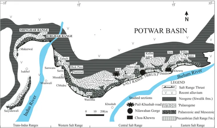
ntroductIonThe stratigraphic committee of Pakistan for-malized the name Dandot Formation for the litho-stratigraphic unit formerly known as the Dandot Group by Noetling (1901). The formation includes the former “Olive Series”, “Eurydesma Beds” and “Conularia Beds” of Wynne (1878), and the “Spec-kled Sandstone” of Waagen (1879). The maximum thickness of the formation is 50 m at the Makrach Nala in the eastern Salt Range (Fatmi 1973; Shah 2009; Fig. 1).
Striking variation in the lithology and thickness of the unit is observed in the eastern and central Salt Range. In the eastern Salt Range, the Dandot Formation is comprised of dark greenish and grey splintery shales and sandstone. Weathered surfaces of the sandstones are reddish and the fresh surfaces show green coloration. In the central Salt
Range, i.e. in the Nilawahan Gorge section, the for-mation comprises green and reddish sandstone al-ternating with shale and siltstone. The sandstone is fine-grained, micaceous, and thoroughly burrowed in the upper parts. Sedimentary structures include flaser bedding, lenticular bedding, ripple cross lami-nations and bioturbation. Abundant glaucony has been reported in some horizons at the Nilawahan Gorge and Pail-Khushab road sections (Shah 1977; Fig. 1).
Reed (1936) described Eurydesma and Conula-ria from the Dandot Formation and asserted that
the fauna co-occurred between the Salt Range, Pa-kistan and Carboniferous-Permian of Australia. Reed (1939) described various non-marine lamelli-branchs in the form of casts and impressions, and correlated them with age-equivalent lamellibranchs from Europe, Africa, China and Burma.
The stratigraphic position of the Dandot Formation is crucial to understand Permian degla-ciation in Pakistan, as the formation overlies the
glacio-fluvial Tobra Formation and underlies the fluvio-continental Warchha Sandstone (Fig. 2). The aim of this paper is to describe the sedimentology of the Dandot Formation in the context of degla-ciation on the northwestern margin of the Indian Plate and correlate the Dandot Formation with other age-equivalent units of Gondwana basins (Fig. 3).
G
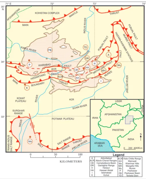
eoloGIcal settInGsThe Northern margin of the Indian Plate is occupied by an active fold and thrust belt of the Salt Range formed in response to the collision between Indian and Eurasian plates (Jaumé & Lillie, 1988; Fig. 4). This ongoing collision between the Indian and Eurasian plates started ~55 million years ago, as a result of northwards drift of the Indian Plate (Ta-hirkheli 1979; Yeats et al. 1984; Baker et al. 1988).
The Salt Range Thrust represents the sou-thernmost fault and is considered the youngest compressional structure of the Himalayan foreland system (Grelaud et al. 2003). The syn-orogenic allu-vium and fan material at the range front are over-ridden by the Precambrian evaporites and overlying
strata (Yeats et al. 1984). The Precambrian Salt Ran-ge Formation is thrust on top of the younRan-ger strata in the eastern Salt Range (Fig. 1), while the oldest rocks exposed in the western Salt Range are repre-sented by the Carboniferous-Permian Nilawahan Group (Gee & Gee 1989).
The Salt Range represents rocks ranging from Pre-Cambrian to Tertiary (Shah 1977; Gee & Gee 1989). These rocks units are distributed in the ea-stern, central and western part of the Salt Range. The Carboniferous-Permian succession of the Salt Range Pakistan is subdivided into the dominantly continental Lower Permian Nilawahan Group of the Gondwanan realm and the overlying shallow marine Middle to Upper Permian Tethyan Zaluch Group (Wardlaw & Pogue 1995; Jan et al. 2009; Jan & Stephenson 2011; Stephenson et al. 2013; Fig. 2). The Upper Pennsylvanian-Asselian Tobra For-mation represents the lowermost forFor-mation of the Nilawahan Group deposited periglacially (Shah et al. 2010; Fig. 2). It displays palaeontological and se-dimentological similarities with the middle part of the Al Khlata Formation of Oman and Unayzah B member of Saudi Arabia and has been correlated with Al Khlata reservoir production units AK P5 to AK P1 of Petroleum Development Oman (PDO) Fig. 1 - Location map of the Salt Range and Trans Indus ranges, showing Choa-Khewra road, Nilawahan Gorge and Pail-Khushab road
and south Oman 2165B Biozone (Jan & Stephen-son 2011).
The Tobra Formation is overlain by the Dan-dot Formation in the eastern Salt Range; however it is absent in the western Salt Range and Khisor Ran-ge where the Warchha Sandstone directly overlies the Tobra Formation (Fig. 2). The lower contact of the Dandot Formation is gradational with the Tobra Formation (Ahmad 1970; Shah & Sastry 1973; Di-ckins 1996; Fig. 2). The upper contact is sharp with the Warchha Sandstone and is marked by an abrupt change in the lithology and sedimentary structures (Fig. 2). The Warchha Sandstone consists of me-dium- to coarse-grained, purple, arkosic sandstone, conglomeratic in places, with interbeds of reddish shale, and represents an arid paleoclimate (Gha-zi & Mountney 2009; 2011). The unit is barren of palynomorphs (Jan 2012), however an Artinskian age has been assigned to it based on plant megafos-sils, including Glossopteris, Gangamopteris, Samaropsis
and Ottokaria (Virkki 1939).
The overlying Sardhai Formation (Fig. 2) re-presents deposition in lacustrine to shallow-marine settings and has been correlated with the “Khuff transition section” of Oman and the “basal Khuff clastics” of Saudi Arabia within the Gharif Forma-tion (Jan et al. 2009). The overlying Zaluch Group represents a dominantly carbonate succession (i.e. the Amb, Wargal and Chiddru formations), develo-ped on a carbonate platform on the north-western Tethyan margin of the Indian Plate representing shallow marine to inter-tidal deposition (Mertmann 2003; Jan et al. 2009; Jan & Stephenson 2011).
MethodoloGy
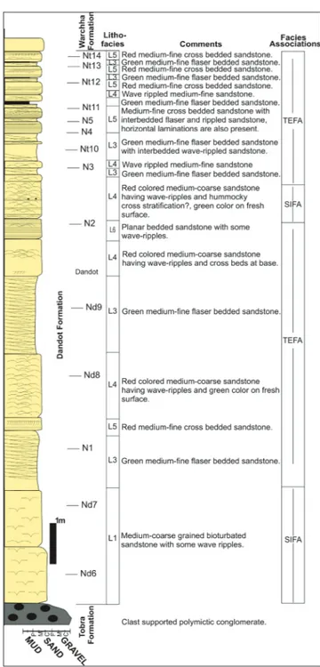
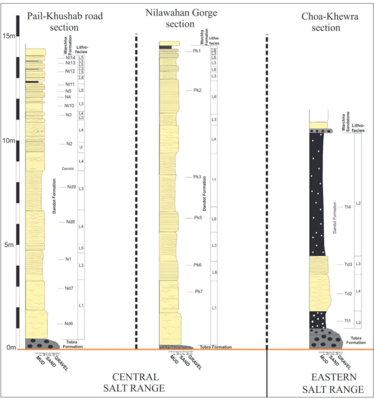
Sedimentological analyses of the Dandot Formation were carried out at the Choa-Khewra road section (eastern Salt Range; N 32° 39’ 59.3’’ E 72° 59’ 12.8’’; Figs 1 and 5), the Pail-Khushab road section (central Salt Range; N 32° 35’ 49.42’’ E 72° 27’ 15.7’’; Figs 1 and 6) and the Nilawahan Gorge section (central Salt Range; N 32° 58’ 32.0’’, E 72° 45’ 56.5’’; Figs 1 and 7). The locations are accessible and represent various intervals within the succession. Field observations, samples for petrography and grain size analysis from the formation were collected (Figs 5, 6 and 7). Proportions of the framework grains were counted using traditional methods. A Nikon polarizing LV 100ND microscope with DS-Fi2 Nikon digital camera was used for counting and photomicroscopy.
s
edIMentoloGIcalInvestIGatIonThe Dandot Formation (Fig. 1) shows lateral and vertical changes in the lithology with the fol-lowing lithofacies and facies associations:
Fig. 2 - Carboniferous–Permian stratigraphy of the Salt Range and Trans Indus ranges, Pakistan. The Gondwana succession, i.e. Nilawahan Group is represented by the Tobra, Dandot, Warchha and Sardhai formations. The Dandot Formation is not developed in the Trans Indus ranges. The overlying Zaluch Group is represented by Amb, Wargal and Chhidru formations (After Jan et al. 2009).
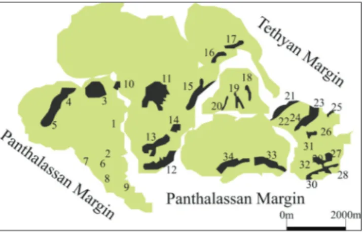
Fig. 3 - Chief Carboniferous-Permian basins of Gondwana, 1-9: South American basins, 10-15: South African basins, 16: Ye-men, 17: Oman, 18: Himalayan zone, 19-20: Indian basins, 21- 32: Australian basins, 33- 34: Antarctic basins (After Stephenson 2008; Jan 2014).
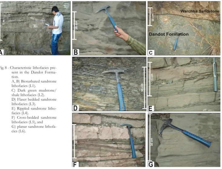
Bioturbated sandstone lithofacies (L1).
The bioturbated sandstone is present in the lower-most part of the Dandot Formation along with the contact of the underlying Tobra Formation and is comprised of fine to medium-grained sandstone (i.e. Figs 6 and 7). The lithofacies is 3.5 m-thick in the both stratigraphic sections, and is overlain by flaser bedded sandstone at the Pail-Khushab road section and planar sandstone at the Nilawahan Gorge section (Fig. 8A and B). The sandstone is thoroughly bioturbated and the intensity decreases upwards. Rootlets occur at the top of the bedding planes in the upper parts of the formation, asso-ciated with horizontally laminated sandstone. The sandstones are internally featureless, having erosive basal surfaces and having cross beds towards the top of the unit. The upper contact with the planar bedded sandstone lithofacies (L6) is sharp. Hori-zontal burrows and glaucony are common on the
bedding planes of the sandstone. The lithofacies displays tabular geometry in both sections.
The base of the formation is erosive and gra-des upwards into wave-rippled sandstone lithofacies, which contains hummocky cross stratification and represents shoreface sandstone (Reading 1996; Duke 1990; Cheel & Leckie 1993). The lithofacies represents deposition during flooding, resulting in the winnowing of the shoreface sandstones by waves or tides (Shukla & Singh 1990; Davies & Walker 1993; MacEachern et al. 1999; Al-Qayim et al. 2005). The cross-bedded san-dstones were deposited in estuarine or tidal channels cutting across the lagoonal fill, where bioturbation also developed in protected areas (Singh & Shukla 1991). However, the absence of erosional surfaces and the tabular geometry of the lithofacies seldom support deposition in estuarine or tidal channels (Dalrymple et al. 1991). Glaucony present in the sandstone also supports deposition in a shallow marine environment.
Fig. 4 - Tectonic Map of Northern Pa-kistan, showing major structu-ral boundaries (After Hylland et al. 1988).
Dark green mudstone/shale lithofacies (L2). Dark green splintery shales constitute the
basal part of the Dandot Formation at the Choa-Khewra road section (Fig. 1) and are repeated in the uppermost part of the formation beneath the contact with the overlying Warchha Sandstone (Figs 4 and 8C). The thickness of L2 varies from 0.8 m in the basal part to 6 m in the uppermost part. The lower L2 unit contains scattered clasts of varying compositions including granite, volcanic, and sedi-mentary lithics derived from the underlying Tobra Formation. This unit grades into rippled sandsto-ne, showing soft sediment deformation in the up-per parts (Fig. 8C). The number of scattered clasts increases in the upper part of the formation. The lower contact of L2 is sharp with the underlying Tobra Formation, however it does not show erosive surfaces. L2 possesses a tabular geometry.
Fielding et al. (2006) attributed the presence of clasts to the melting of icebergs and the drop-ping of clasts in the marine environment. The absence of varves and other glacial features point
to a non-glacial origin. The dark green shale shows deposition in the nearshore environment (Genne-seaux 1962; Stanley & Swift 1967). The presence of soft sediment deformation also indicates deposition in a marine environment (Crowell 1956; Altermann 1986).
Flaser bedded sandstone lithofacies (L3).
L3 is present at the Pail-Khushab road and Nila-wahan Gorge sections (Figs 6 and 7). The sandsto-Fig. 5 - The distribution of lithofacies and facies associations of
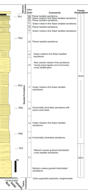
the Dandot Formation at the Choa-Khewra road section, eastern Salt Range. See the figure inset for key.
Fig. 6 - The distribution of lithofacies and facies associations of the Dandot Formation at the Pail-Khushab road section. See inset figure 5 for key.
nes are fine- to medium grained, well sorted and green in color. The lithofacies is repeated several times at the Pail-Khushab road section (Fig. 6), ha-ving fining upward succession with thickness ran-ging from 0.2 to 3 m (Fig. 8D). Sand lenses are 1 to 2 cm in thickness with internal laminations, cross laminations and asymmetric ripples. In places these sand flasers sharply overlie cross-bedded sandsto-nes. Similar fining upward successions are present at the Nilawahan Gorge section (Fig. 7) but with lesser
thicknesses than those present at the Pail-Khushab road section (Fig. 6). In places, flaser and lenticular bedding is replaced by tidal bedding, i.e. cyclic pat-tern of planar bedded sandstone and shale.
Flaser bedded sandstones are interpreted to represent deposition in a tidal setting, i.e., tidal flats and tidal channels (Terwindt 1971). The repeated fining upward cycles represent tidally-influenced estuarine channel fills (Fielding et al. 2006).
Rippled sandstone lithofacies (L4). This
facies constitutes fine grained, well sorted sandsto-ne with a red weathered surface and green fresh sur-face color. The sandstone is laminated with abun-dant wave ripples, combined flow ripples, and rare climbing ripples. Low angle hummocky cross stra-tification and herringbone cross strastra-tification are common (Figs 5 to 7 and 8E). The upper surfaces of the ripples in places are marked by thin shale beds. The rippled sandstone grades into flaser bed-ded sandstones. This lithofacies is present in all the three stratigraphic sections and is repeated at the Pail-Khushab and Nilawahan Gorge sections with 0.2 m to 2 m variation in thickness (Figs 5 to 7). At the Nilawahan Gorge section, L4 displays thicke-ning beds giving massive appearance and has fine- to medium grain size. Current-ripples predominate over asymmetrical ripples. These sandstones grade upward into flaser bedded units and overlie biotur-bated sandstone lithofacies. Extensive horizontal burrows are present on the upper surfaces of these rippled beds in the upper parts of the formation. At the Choa-Khewra road section, this lithofacies is similar in appearance to that found at the Nila-wahan Gorge section, with sandstone being much coarser, having red color with green shale on the rippled surfaces (Fig. 5).
An abundance of wave ripples and current ripples points towards deposition in a coastal envi-ronment (Reineck & Singh 1971; Wunderlich 1972). The association of this lithofacies with flaser bed-ded sandstone lithofacies upwards represents de-position in the intertidal environment (Reineck & Singh 1983). Thick sandstones with asymmetrical ripples of the Nilawahan Gorge and Choa-Khewra road sections represent deposition in relatively de-eper waters of the shoreface (Newton 1968). The presence of hummocky cross stratification also supports this interpretation (Newton 1968; Reineck & Singh 1983). The comparatively large size of the Fig. 7 - The distribution of lithofacies and facies associations of
the Dandot Formation at the Nilawahan Gorge section. See inset figure 5 for key.
Gorge sections only (Figs 5 to 7). This lithofacies is repeated vertically in the stratigraphic sections and is associated with the bioturbated sandstone below and flaser bedded sandstone above. It is also asso-ciated with the rippled sandstone lithofacies. The facies comprises medium to coarse-grained, well sorted, and friable sandstones and occurs in beds (thickness varies from 0.5 to 2 m) with planar/hori-zontal laminations. A fining upward trend is obser-ved in L6 and grades into flaser bedded units (Figs 6 and 7). Low angle cross laminations also occur towards the top in the lithofacies (Fig. 6G). At Nila-wahan Gorge section, horizontal burrows are found on the upper surfaces of the thin horizontal fine clayey beds interlaminated with sandstone (Fig. 7). These beds constitute fine grained well sorted and friable sandstones.
The stratigraphic position of L6 suggests an intertidal depositional setting. In the Nilawahan Gorge, the heterolithic bedding in L6 also repre-sents cyclic change in the energy conditions due to the tidal activities.
ripples is also evidence of deposition in deeper wa-ters (Reineck & Singh 1983).
Cross-bedded sandstone lithofacies (L5).
L5 is present at the Pail-Khushab road section in the central Salt Range and comprises coarse grai-ned, occasionally friable reddish to whitish green sandstone (Figs 6 and 8F). This lithofacies is pre-sent in the middle and upper parts. Low angle pla-nar cross bed sets are present within the sandstones, and are associated with the horizontally-laminated sandstone, and grade upwards into flaser bedded sandstone (Figs 6 and 8F). At some places, low an-gle planar cross bed sets also occur (Fig. 6).
The association of this lithofacies with the planar sandstones lithofacies and tidally influen-ced channel fills of estuarine environment suggest deposition on tidal flats in the tidal channels and estuarine fills (Davis 1983; Dalrymple et al. 1991).
Planar sandstone lithofacies (L6). L6 is
present at the Pail-Khushab road and Nilawahan Fig. 8 - Characteristic lithofacies
pre-sent in the Dandot Forma-tion.
A, B) Bioturbated sandstone lithofacies (L1).
C) Dark green mudstone/ shale lithofacies (L2). D) Flaser bedded sandstone lithofacies (L3).
E) Rippled sandstone litho-facies (L4).
F) Cross-bedded sandstone lithofacies (L5), and G) planar sandstone lithofa-cies (L6).
F
acIes assocIatIonsThe lithofacies in the Dandot Formation can be grouped into two facies associations:
Shoreface and inner shelf facies associa-tions (SIFA). SIFA is composed of L1 and L2. Part
of the rippled sandstone lithofacies (i.e. L4) is also included in this association (Figs 5 to 7). The pre-sence of sedimentary structures and textural tren-ds and presence of wave ripples, hummocky cross stratification, bioturbation and mudstone/shale containing scattered pebbles indicate deposition in nearshore to slightly deep water settings (Reading 1996; Fielding et al. 2006). The shoreface and inner shelf facies association is present in all three strati-graphic sections (Figs 5, 6 and 7). The Dandot For-mation at the Choa-Khewra road section (i.e. ea-stern Salt Range) contains pebbly mudstone/shale of this association in the lower and upper parts. In the central Salt Range (Fig. 1), lithologies represen-tative of this facies association are restricted to the lowermost part of the Dandot Formation.
Tidal flat and estuarine facies association (TEFA). TEFA comprises L3, L4, L5 and L6 (Figs
5 to 7). The abundance of wave ripples, combined flow ripples, heterolithic bedding, tidal channel fill sequences and bioturbation indicate deposition of this facies association in tidal flats and an estuarine environment (Reineck & Singh 1983; Fielding et al. 2006). This facies association is present in all the three stratigraphic sections. At the Choa-Khewra road section, rippled sandstone and flaser bedded sandstone of this facies association are present in the middle part of the Dandot Formation while the other lithologies representing this facies associa-tion are present in the Nilawahan Gorge and Pail-Khushab road sections, where they represent the middle and upper parts of the formation.
v
ertIcalandlateralFacIesvarIatIonsThe Dandot Formation in the eastern part of the Salt Range (Fig. 1) shows relatively deeper facies of SIFA at the base which grade upwards into sho-reface sandstone with development of ripples and hummocks subsequent to sea level rise possibly as a result of Carboniferous-Permian deglaciation
(Di-ckins 1996; Angiolini et al. 2003; Ghazi & Mountney 2011; Fig. 9). In the central part of the Salt Range, i.e., Pail-Khushab road and Nilawahan Gorge sec-tions (Figs 1, 6, 7 and 9), trangressive bioturbated shoreface sandstones grade upwards into relatively shallow marine bioturbated sandstone. The pro-gradation continues and the succession grades into tidal flat and estuarine sandstones and heteroliths. Several cycles of the fining upward successions in-dicate that the presence of estuarine/tidal channels is quite dominant in the upper and middle parts of the Dandot Formation at Nilawahan Gorge and Pail-Khushab road sections. Overall, a progradatio-nal sequence is recorded in the Dandot Formation which sharply truncates against the fluvial succes-sion of the overlying Warchha Sandstone (Figs 2 to 7).
In the east, the Dandot Formation constitutes deeper facies of SIFA with presence of mudstone/ shales with scattered pebbles. In the central part of the Salt Range, lithologies of shallow-marine set-tings predominate. Shoreface facies are present only at the basal part while the rest of the formation ap-pears to have been deposited in a marginal marine setting, i.e., tidal flat and tide-dominated estuarine sequence. It is suggested that the eastern part of the Salt Range occupied a relatively distal position on the northwestern margin of the Indian Plate and as a result relatively deeper water facies were deposited in this part and the western part occupied a more proximal position and thus the central and western parts represent shallower facies.
Depositional system and regional set-ting. The distribution of the lithofacies at the three
stratigraphic sections (i.e. Choa-Khewra road, Pail-Khushab road and Nilawahan Gorge sections; Figs 5, 6 and 7 respectively) shows interbedding with little cyclicity in the upper parts of the formation in two stratigraphic sections i.e. Pail-Khushab road and Nilawahan Gorge sections (Figs 6 and 7), and in the middle part of the formation at the Nilawahan Gorge section (Fig. 7). Major erosional surfaces like sequence boundaries were not identified within the vertical stacking patterns except the surface separa-ting estuarine channel fills from the shoreface facies evident at the basal part of the Dandot Formation at Pail-Khushab road and Nilawahan Gorge section (Figs 6 and 7). This surface can be considered a se-quence boundary because of an abrupt change in
the facies and because the surface is traceable late-rally for long distances. At the Choa-Khewra road section, an abrupt deepening is observed and litho-facies L3 is overlain by L2 of shoreface to inner shelf environment. Similar surfaces showing abrupt deepening are also present in the Nilawahan Gorge section (Fig. 5) in the middle and upper part where the cyclicity of upper shoreface sands and hetero-lithic bedding of the TEFA is observed. In the
lo-wer to middle part, the pattern in the sequence may be attributed to the short term cyclicity in sea level (Fig. 7), while in the upper part (Fig. 5), the presence of shoreface sandstone interbedded with the tidal flat and estuarine fill facies association represents abrupt deepening and thus a marine flooding surfa-ce. Overall, the vertical stacking pattern in the Dandot Formation represents a progradational sequence with shallow marine facies overlying the deep marine facies. Fig. 9 - The Dandot Formation facies correlation in the eastern and central Salt Range. Refer to figure 1 for locations and inset figure 5 for key.
s
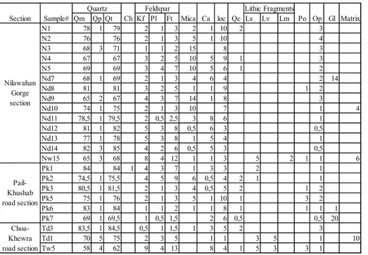
andstone petroGraphySandstone constitutes about 85%, of the Dandot Formation; shale and mudstone is less common (Figs 5 to 7). The sandstones are homo-geneous with fine- to medium-grain size, however occasional coarse-grained sandstones occur in the basal parts of the formation. Sandstones are mode-rately to well sorted and very well sorted in places. Texturally, the grains are rounded to sub-rounded, with occasional angular to sub-angular shapes and display loose packing; however in some places san-dstone is compact and tightly packed. Contacts between the grains are mostly straight, with some concavo-convex, tangential and rare sutured con-tacts (Fig. 10C). Two sandstone samples collected from the base of the overlying Warchha Sandsto-ne are moderately to poorly sorted and feldspatho-quartzose (Tab. 1).
Characteristics of the framework grains.
Clasts. Quartz crystals constitute 65-84% of
the rock; 99% are monocrystalline, clear of inclu-sions, and mostly display unitary or slightly undu-latory extinction (Figs 10A and B). Abraded over-growths also occur. Mostly altered feldspar forms 1-9% of the rock, alkali feldspar prevails over pla-gioclase, and microcline is rare (Tab. 1). Sedimen-tary lithics (i.e. siltstone and rare chert) represent 0.2% on average and up to 2% of the rock (Fig. 10F). Igneous and metamorphic lithics seldom oc-cur. Micas are aligned parallel to the bedding planes
and are most common in heterolithic and fine grai-ned sandstone, decreasing in medium and coarse sandstone. Muscovite is more common than bio-tite and accounts for 4.6% on average of the total grains. Glaucony was observed only in bioturbated sandstone lithofacies at the base of the Dandot Formation (Figs 10B & E). Opaque magnetite and haematite comprise ̴ 1.8% of the total rock grains (Tab. 1).
Cement. The color of the sandstone varies
between red, reddish green, green, grey and white. This can be attributed to the types of cement and amount of the interstitial haematite in the matrix (Schluger 1976). Haematite is dominant with very rare siderite observed, and is found as filling in pore spaces, corroding the grain boundaries and coating and replacing grains and other types of cement. Calcite constitutes 2.8% of the rock grains. Per-centages of calcite tend to increase upwards in the section with a decrease in ferruginous cementing material. The volumetric percentage of quartz over-growths is 0.62%, and some of these overover-growths have a rounded periphery while others are recycled, precipitated around the grains in original sandstone.
Provenance. Twenty representative samples
from three stratigraphic sections were selected for provenance studies. Sandstone compositions mainly depend on the type of the source rock, tectonic settings, climate conditions in the source area, nature, and chemical composition (in case of water) of the transporting agent and depositional settings (Weltje & Eynatten 2004). In general,
com-Qm Qp Qt Kf Pl Ft Ls Lv Lm N1 78 1 79 2 1 3 2 1 10 2 3 N2 76 76 2 1 3 5 1 10 4 N3 68 3 71 1 1 2 15 8 3 N4 67 67 3 2 5 10 5 9 1 3 N5 69 69 3 4 7 10 5 6 1 2 Nd7 68 1 69 2 1 3 4 6 4 2 14 Nd8 81 81 3 2 5 1 1 9 1 2 Nd9 65 2 67 4 3 7 14 1 8 3 Nd10 74 1 75 2 1 3 10 7 1 4 Nd11 78,5 1 79,5 2 0,5 2,5 3 8 6 1 Nd12 81 1 82 5 3 8 0,5 6 3 0,5 Nd13 77 1 78 5 3 8 1 5 4 1 Nd14 82 3 85 4 2 6 0,5 5 3 0,5 Nw15 65 3 68 8 4 12 1 1 3 5 2 1 1 6 Pk1 84 84 1 4 3 7 1 3 3 2 1 Pk2 74,5 1 75,5 4 5 9 6 0,5 4 2 1 1 Pk3 80,5 1 81,5 2 1 3 4 0,5 5 2 1 2 Pk5 75 1 76 2 1 3 5 1 10 1 3 2 Pk6 83 1 84 1 1 2 1 1 8 1 1 1 1 Pk7 69 1 69,5 1 0,5 1,5 2 6 0,5 0,5 20 Td3 83,5 1 84,5 0,5 1 1,5 1 3 5 2 3 Td1 70 5 75 2 3 5 1 1 3 5 1 10 Tw5 58 4 62 9 4 13 8 4 1 5 3 3 1 Pail-Khushab road section Choa-Khewra road section Po Op Gl Matrix Nilawahan Gorge section
Quartz Feldspar Lithic Fragments
Section Sample# Ch Mica Ca loc Qc
Tab. 1 - Proportions of rock components of the sandstone of the Dandot Formation. Sample Tt1 belongs to underlying Tobra Formation and Tw5 and Nw15 belong to overlying Warchha Sandstone. For samples locations see figures 5, 6 and 7. Qm = Non undulose microcrystalline quartz, Qp = Polycrystalline quartz, Qt = To-tal quartz present (monocrysTo-tal- (monocrystal-line and polycrystal(monocrystal-line including chert), Ch = Chert, Kf = Alkali feldspar (orthoclase and micro-cline), Pl = Plagioclase feldspar, Ft = Total feldspar (both K-feldspar and plagioclase), Ca = Clacite cement, Ioc = Iron oxi-de/hydroxide, Qc = Quartz ce-ment, Ls = Sedimentary lithics, Lv = Volcanic lithics, Lm = Me-tamorphic lithics, Po = Porosity, Op = Opaque minerals, Gl = Glaucony.
positions of the sandstones are not much affected by physical processes (Garzanti et al. 2015). Types of quartz grains could be used alone to determine the source rock type. Monocrystalline quartz having uniform to slightly undulose extinction is conside-red to be derived from plutonic rocks, e.g. granites (Basu et al. 1975; Pettijohn et al. 1987; Datta 2005). Polycrystalline and monocrystalline quartz grains ha-ving undulatory extinction are generally derived from a metamorphic source (Blatt et al. 1980; Asiedu et al. 2000), however these are seldom found in the stu-died samples. The K-feldspar is mainly derived from
crystalline rocks i.e., granites and gneisses (Ghose & Kumar 2000; Tucker 2001). Higher ratios of K-feld-spar as compared to plagioclase indicate derivation from mixed plutonic and metamorphic source (Di-ckinson 1970; Tucker 2001). Further, the presence of rounded overgrowths of quartz in some quartz grains indicate recycled sedimentary sources (Basu et al. 1975; Tucker 2001; Jafarzadeh & Barzi 2008). Based on the petrographic evidence, e.g. presence of sedimentary lithics, abundance of monocrystalline quartz and presence of abraded overgrows, a deriva-tion from sedimentary source is interpreted (Fig. 7).
The deposition of the Dandot Formation took place in a cold climate. The sandstone repre-sents derivation from crystalline rocks and enrich-ment of the quartz in the sandstone is because of the recycled sedimentary source rocks. Extensive reworking in the shallow marine environment was not responsible for the composition of the sandsto-ne which is mainly affected by the source area.
s
tratIGraphIc settInGThe upper part of the Tobra Formation at the Choa-Khewra road section contains palynomorphs assignable to the earliest Permian 2141B Biozo-ne (Stephenson et al. 2013). In Oman, the 2141B Biozone is closely associated with the Rahab Shale Member, a widespread shale unit in Oman, which is considered to represent part of a Permian deglacia-tion sequence which culminates in the marine beds of the Lower Gharif Member, interpreted as due to post glacial marine transgression (Stephenson et al. 2005).
Palynological sampling of the Dandot mation conformably overlying the Tobra For-mation yielded only barren samples, however the marine nature of the Dandot Formation and its stratigraphic position suggests that like the Lower Gharif Member it may represent post glacial marine transgression.
A similar transition is seen elsewhere across Gondwana (Angiolini et al. 2003; Stephenson et al. 2007) where deposition of marine strata occurred on the top of glacially-dominated facies.
For example in India, a transition at the top of the glacigene Talchir Formation is observed, whereby the basin evolution is controlled by degla-ciation as a result of climatic warming (Maejima et al. 2004). The Talchir Formation deposits are repre-sented by mudstone with intercalations of sandsto-ne and siltstosandsto-ne. The mudstosandsto-ne shows discrete beds of ripple cross- or climbing-ripple cross-laminated siltstone. The presence of a marine incursion at the top of the Talchir Formation in India is attri-buted to a eustatic sea level rise associated with the Carboniferous-Permian deglaciation (Maejima et al. 2004). This is then followed by the deposition of the fluvial succession of the Karharbari Forma-tion (Maejima et al. 2004; Bhattacharya et al. 2005), which can be correlated with the Warchha
Sandsto-ne (Maejima et al. 2004).
The uppermost part of the Itarare group in Brazil, the Taciba Formation, also records the de-glaciation sequence of the Early Permian and con-tains marine invertebrates including brachiopods overlying the Campo Muroa Formation (Vesely & Assine 2006).
A similar marine transgression has been observed in the Carboniferous-Permian deposits of Australia with the development of marine fauna (e.g. Foster & Waterhouse 1988). The marine fauna of the Dandot Formation e.g. Fenestella fossula, Diela-sma dadanense, Pterinea cf. lata, Nucula pidhensis. Cardio-morpha? pusilla, Maeonia cf. gracilis, Astartila cf. ovalis
and Eurydesma cordatum, reported by Reed (1936) has
been correlated with the “Lower Marine Series” of New South Wales, Australia (Kummel & Teichert 1970). This fauna was attributed by Reed (1936) to the development of contemporaneous marine con-ditions in Australia and Salt Range, Pakistan.
The age-equivalent unit of the Dandot For-mation in Australia, the Pebbly Beach ForFor-mation represents various stratigraphic surfaces and sta-cking pattern diagnostic of the sequences formed under icehouse conditions, showing cyclicity of the stacking pattern (Fielding et al. 2006). However, the Carboniferous-Permian paleogeographic recon-struction of Gondwana shows that Australian ba-sins were exposed to open oceans whereas the Salt Range basin was located along a narrow depression where the effect of sea level rise was soon domi-nated by progradation due to the uplift of the ba-sement (Valdiya 1997; Garzanti & Sciunnach 1997; Ghazi & Mountney 2011).
c
onclusIonsOverall the Dandot Formation represents deposition in a shallow marine to intertidal envi-ronment.
The sedimentological nature and the strati-graphic position of the Dandot Formation suggests that the Dandot Formation was deposited as a re-sult of global sea level rise associated with the de-mise of Carboniferous-Permian glaciation, however robust biostratigraphy is required to place the Dan-dot Formation within a framework of deglaciation. Petrographic investigations of the Dandot Formation indicate that the sandstones are
compo-sion of the Director of British Geological Survey, UK. The authors acknowledge the comments of Eduardo Garzanti, an anonymous reviewer and Associate Editor (Fabrizio Felletti).
RefeRences
Ahmad F. (1970) - Marine transgression in the Gondwana sys-tem of Peninsular India – A reappraisal. In: Haughton S.H. (Ed.) - Proceedings of Second Gondwana Sympo-sium South Africa, Pretoria, Council for Scientific and Industrial Research: 179-188.
Al-Qayim B., Al-Sanabani J. & Al-Subbary A. K. (2005) - Pa-leoenvironmental implication of marine bioturbated ho-rizons in the Majzir formation, Western Yemen. Arabian J. Sci. Engin., 30(2): 165-180.
Altermann W. (1986) - The upper Paleozoic pebbly mudstone facies of Thailand and Western Malysia-Continental margin Deposits of Paleoeurasia. Geol. Rund. 75(2): 371-381.
Angiolini L., Balini M., Garzanti E., Nicora A. & Tintori A. (2003) - Gondwanan deglaciation and opening of Neo-tethys: the Al Khlata and Saiwan Formations of Interior Oman. Palaeogeogr., Palaeoclimatol., Palaeoecol., 196(1-2): 99-123.
Asiedu D.K., Suzui S. & Shibata T. (2000) - Provenance of sandstones from the Lower Cretaceous Sasayama Group, inner zone of southwest Japan. Sediment. Geol., 131: 9-24.
Baker D.M., Lillie R.J., Yeats R.S., Johnson G.D., Yousuf M. & Zamin A.S.H. (1988) - Development of the Himalayan frontal thrust zone: Salt Range, Pakistan. Geology, 16: 3-7. Basu A., Young S.W., Lee J., Sutter W., Calvin J. & Mack G.H.
(1975) - Re-evaluation of the use of undulatory extinc-tion and polycrystallinity in detrital quartz for prov-enance interpretation. J. Sedim. Petrol., 45: 873-882. Bhattacharya H.N., Chakraborty A. & Bhattacharya B. (2005)
- Significance of transition between Talchir Forma-tion and Karharbari FormaForma-tion in Lower Gondwana basin evolution - A study in West Bokaro Coal basin, Jharkhand, India. J. Earth. Syst. Sci., 114(3): 275-286. Blatt H., Middleton G. & Murray R. (1980) - Origin of
Sedi-mentary Rocks. Prentice-Hall, New Jersey, 782 pp. Cheel R.J. and Leckie D.A. (2009) - Hummocky
cross-stratifi-cation. Sedim. Rev., 1: 31-103.
Crowell J.C. (1956) - Origin of the pebbly mudstone. J. Geol. Soc. Am., 68(8): 993-1009.
king Formation (Lower Cretaceous), Alberta. Bull. Can. Petrol. Geol., 41(4): 407-421.
Davis R.A. (1983) - Depositional Systems. Prentice Hall, En-glewood Cliffs, 254 pp.
Dickins J.M. (1996) - Problems of Late Paleozoic glaciations in Australia and subsequent climate in Permain. Palaeo-geogr., Palaeoclimatol., Palaeoecol., 125: 185-197.
Dickinson W.R. (1970) - Interpreting detrital modes of gray-wacke and arkose. J. Sediment. Petrol., 40: 695-707. Duke W.L. (1990) - Geostrophic circulation or shallow marine
turbidity currents? The dilemma of paleoflow patterns in storminfluenced prograding shoreline systems. J. Sedi-ment. Petrol., 60: 870-883.
Fatmi A.N. (1973) - Lithostratigraphic units of Kohat-Potwar Province, Indus Basin. Geol. Surv. Pakistan Memoir, 10: 1-80.
Fielding C.R., Bann K.L., Maceachern J.A., Tye S.C. & Jones B.G. (2006) - Cyclicity in the nearshore marine to coast-al, Lower Permian, Pebbley Beach Formation, southern Sydney Basin, Australia: a record of relative sea-level fluctuations at the close of the Late Palaeozoic Gond-wanan ice age. Sedimentology, 53(2): 435-463.
Foster C.B. & Waterhouse J. B. (1988) - The Granulatisporites confluens Oppel-zone and Early Permian marine fau-nas from the Grant Formation on the Barbwire Terrace, Canning Basin, Western Australia. J. Geol. Soc. Australia, 35(2): 135-157.
Garzanti E. & Sciunnach D. (1997) - Early Carboniferous on-set of Gondwanian glaciations and Neo-tethyan rifting in South Tibet. Earth Planet. Sci. Lett., 148; 359–365. Garzanti E., Resentini A., Ando S., Vezzoli G., Pereira A. &
Vermeesch P. (2015) - Physical controls on sandstone composition and durability of detrital minerals during ultra-long distance littoral and Eoalian transport (Na-mibia and southern Angola). Sedimentology, 62(4): 971-996.
Gee E. R. & Gee D. G. (1989) - Overview of the geology and structure of the Salt Range, with observations on related areas of northern Pakistan. Geol. Soc. America Spec. Pap., 232: 95-112.
Genneseaux M. (1962) - Les canyons de la baie das Agnes leur remplesge sedimentaire et leur role dans la sedi-mentation profonde. In: Altermann W. (Ed.) - The up-per Paleozoic pebbly mudstone facies of Thailand and Western Malysia-Continental margin Deposits of Pa-leoeurasia. Geol. Rund., 75(2): 371-381.
Ghazi S. & Mountney N.P. (2009) - Facies and architectural element analysis of a meandering fluvial succession: the Permian Warchha Sandstone, Salt Range, Pakistan. Sedim. Geol., 221: 99-126.
Ghazi S. & Mountney N.P. (2011) - Petrography and prov-enance of Early Permian Fluvial Warchha Sandstone, Salt Range, Pakistan. Sedim. Geol., 233: 88-110.
Ghose S.K. & Kumar R. (2000) - Petrology of Neogene Siwa-lik Sandstone of the Himalayan foreland basin, Garhwal Himalaya: implication for source area tectonics and cli-mate. J. Geol. Soc. India, 55: 1-15.
Grelaud S., Sassi W., de Lamotte D. F., Jaswal T. & Roure F. (2002) - Kinematics of eastern Salt Range and South Potwar Basin (Pakistan): a new scenario. J. Mar. Petrol. Geol., 19: 1127-1139.
Hylland M.D., Riaz M. & Ahmad S. (1988) - Stratigraphy and structure of Southern Ghandghar Range, Pakistan. Geol. Bull. Univ. Peshawar, 21: 1-14.
Jafarzadeh M. & Barzi M.H. (2008) - Petrography and Geo-chemistry of Ahwaz Sandstone member of Asmari For-mation, Zagros, Iran. Implication for provenance and tectonic settings. Rev. Mex. Cien. Geol., 25(2): 247-260. Jan I.U. & Stephenson M.H. (2011) - Palynology and
corre-lation of the Upper Pennsylvanian Tobra Formation from Zaluch Nala, Salt Range, Pakistan. Palynology, 35: 212-225.
Jan I.U. Stephenson M.H. & Khan F.R. (2009) - Palynostrati-graphic correlation of the Sardhai Formation (Permian) of Pakistan. Rev. Palaeobot. Palynol., 158(1): 72-82. Jan I.U. (2012) - Investigating the palynostratigraphy and
pa-laeoenvironments of the southern Palaeotethyan Car-boniferous-Permian succession of the Salt Range, Paki-stan. Ph.D. Thesis, University of Leicester, UK. Jan I.U (2014) - The development in the
Carboniferous-Perm-ian Nilawahan Group palynology and stratigraphic cor-relation: A brief review. J. Earth Syst. Sci., 123(1): 21-32. Jaumé S.C. & Lillie R.J. (1988) - Mechanics of the Salt-Range
Potwar-Plateau, Pakistan: A fold and thrust belt under-lain by evaporites. Tectonics, 7: 57-71.
Kummel B. & Teichert C. (1970) - Stratigraphy and paleontol-ogy of the Permian-Triassic Boundary Beds, Salt Range and Trans-Indus Ranges, West Pakistan. In: Kummel B. & Teichert C. (Eds) - Stratigraphic Boundary Problems: Permian and Triassic of West Pakistan. Univ. Kansas Dept. Geol. Spec. Publ., 4: 2-110.
Maceachern J.A., Zaitlin B.A. & Pemberton S.G. (1999) - A sharp-based sandstone of the viking formation, joffre field, alberta, canada: criteria for recognition of trans-gressively incised shoreface complexes. J. Sediment. Res., 69(4): 86-892.
Maejima W., Das R., Pandya K.L. & Hayashi M. (2004) - De-glacial Control on Sedimentation and Basin Evolution of Permo-Carboniferous Talchir Formation, Talchir Gondwana Basin, Orissa, India. Gondwana Res., 7(2): 339-352.
Mertmann D. (2003) - Evolution of the marine Permian car-bonate platform in the Salt Range (Pakistan). Palaeogeogr., Palaeoclimatol., Palaeoecol., 191: 373-384.
Newton R.S. (1968) - Internal structure of wave formed ripple marks in nearshore zone. Sedimentology, 11: 275-292. Noetling F. (1901) - Beitrage zur Geologie der Salt Range, in
sbesondere der Permian under Triasuchea Ablagerun-gen. Venues Jahrb. Mineral Beil., 14: 369-471.
Pettijohn F.J. (1975) - Sedimentary Rocks. 3rd ed. Harper & Tow, New York, 628 pp.
Pettijohn F.J., Potter P.E. & Siever R. (1987) - Sand and Sand-stones. Springer Verlag, 533 pp.
Reading G.H. (Ed.) (1996) - Sedimentary Environments: Pro-cesses, Facies and Stratigraphy. Blackwell Scientific Pub-lications Oxford, 245 pp.
Reed F.R.C. (1939) - Non-Marine Lamellibranchs etc. from the ‘Speckled Sandstone’ Formation (Punjabian) of the Salt Range. Rec. Geol. Surv. India, 74(Pt 4): 474-491. Reed F.R.C. (1936) - Some fossils from the Eurydesma and
Conularia beds (Punjabian) of the Salt Range: Geol. Surv. India, Mem., Palaeontologia Indica, ns 23, 361 pp.
Reineck H.E. & Singh I.B. (1971) - Der Golf von Gaeta (Tyr-rhenisches Meer) III. Die Gefuge von Vorstrand und Schelfsedimenten. Senckenbergiana Marit. 3: 185-201. Reineck H.E. & Singh I.B. (1983) - Depositional Sedimentary
Environments, Springer-Verlag, 268 pp.
Schluger P.R. (1976) - Petrology and origin of the red beds of the Perry Formation New Brunswick, Canada, and Maine, USA. J. Sediment. Petrol., 46(1): 22-37.
Shah A., Haneef M., Hanif M. & Jan I. U. (2010) - Lithofacies and palaeoemvironmental analysis of Carboniferous-Permian Nilawahan Group, Salt Range, Pakistan. Paki-stan J. Hydrocarbon Res., 20: 49-52.
Shah S.C. & Sastry C.V. (1973) - Significance of Early Permian marine faunas of Peninsular India. In: Proceedings of 3rd Gondwanan Symposium: 391-395.
Shah S.M.I. (1977) - Stratigraphy of Pakistan. Geol. Surv. Paki-stan, Memoir, 12: 1-5.
Shah S.M.I. (2009) - Stratigraphy of Pakistan. Government of Pakistan Ministry of Petroleum & Natural Resources, Geol. Surv. Pakistan.
Shukla U.K. & Singh I.B. (1990) - Facies analysis of Bujh sand-stone (Lower Cretaceous), Bujh area, Kuchchh. J. Paleon-tol. Soc. India, 35: 189-196.
Singh I.B. & Shukla U.K. (1991) - Significance of trace fossils in the Bujh sandstone (Lower Cretaceous), Bhuj area, Kachchh. J. Paleontol. Soc. India, 36: 121-126.
Stanley D.J. & Swift D.J.P. (1976) - The new concepts of con-tinental margin sedimentation. Application to geological record. Am. Geol. Inst. Washington, p. 206.
Stephenson M.H., Angiolini L. & Leng M.J. (2007) - The Early Permian fossil record of Gondwana and its relationship to deglaciation: a review. In: Williams M., Heywood A.M., Gregory F.J. & Schmidt D.N. (Eds) - Deep-Time perspec-tive on Climate Change: Marrying the signal from Com-puter Models and Biological Proxies. The Micropalaeontol. Soc. Spec. Publ. The Geological Society, London: 169-189.
Stephenson M.H., Jan I.U., Zeki S.A. & Al-Mashaikie K. (2013) - Palynology and correlation of Carboniferous-Permian glacigene rocks of Oman, Yemen and Pakistan. Gondwana Res., 24: 203-211.
Valdiya K.S. (1997) - Himalaya, the northern frontier of East Gondwanaland. Gondwana Res. 1: 2-9.
Vesely F.F. & Assine M.L. (2006) - Deglaciation sequences in the Permo-Carboniferous Itararé Group, Paraná Basin, Southern Brazil. J. South Am. Earth Sci., 22(3-4): 156-168. Virkki C. (1939) - On the occurrence of winged spores in a Lower Gondwana glacial tillite from Australia and in Lower Gondwana shales in India. Indian Acad. Sci., 9: 7-12.
Waagen W. (1879) - Salt Range Fossils. Geol. Surv. India Mem. Palaeontol. Indica, 1: 1-7.
Wardlaw B.R. & Pogue K.R. (1995) - The Permians of Paki-stan. In: Scholle P.A., Peryt T.M. & Ulmer-Scholle P.M. (Eds) - The Permians of Northern Pangea. Palaeo-geography, Palaeoclimates, Stratigraphy vol. 1: 215-224. Springer Verlag, New York.
Weltje J.G. & Eynatten H.V. (2004) - Quantitative analysis of sandstones: review and outlook. Sedim. Geol. 171: 1-11. Wunderlich F. (1972) - Georgia Coastal region, Sapelo Island,
U.S.A. Sedimentology and biology 3. Beach dynamics and beach development. Senckenbergiana Marit., 4: 47-49. Wynne A.B. (1878) - On the geology of the Salt Range in the
Punjab. Geol. Surv. India Mem., 14: 313.
Yeats R. S., Khan S. H. and Akthar, M., 1984. Late Quaternary deformation of the Salt Range of Pakistan. Geol. Soc. America Bull., 95: 958-966.