Università Politecnica delle Marche
Facoltà di Scienze
Dottorato di Ricerca in Biologia ed Ecologia Marina
XXXI Ciclo N.S.
Developing a methodology for ecosystem assessment of
Tam Giang-Cau Hai lagoon and estuaries of
Thua Thien Hue and Quang Tri Provinces, Central Vietnam
Tesi di Dottorato di:
Nguyen Vu Bao Chi
Tutore:
Prof. Massimo Sarti
Co-Tutori:
Prof. Alessandra Negri
Prof. Anna Sabbatini
Academic thesis: Declaration of Authorship
I, Nguyen Vu Bao Chi, declare that this thesis and the work presented in it are my own and has been generated by me as the result of my own original research.
The title of the thesis is: ―Developing a methodology for ecosystem assessment of Tam Giang-Cau Hai lagoon and estuaries of Thua Thien Hue and Quang Tri Provinces, Central Vietnam‖
I confirm that:
This work was done wholly or mainly while in candidature for a research degree at this University;
Where any part of this thesis has previously been submitted for a degree or any other qualification at this University or any other institution, this has been clearly stated;
Where I have consulted the published work of others, this is always clearly attributed;
Where I have quoted from the work of others, the source is always given. With the exception of such quotations, this thesis is entirely my own work;
I have acknowledged all main sources of help;
Where the thesis is based on work done by myself jointly with others, I have made clear exactly what was done by others and what I have contributed myself;
Either none of this work has been published before submission.
Signed: Nguyen Vu Bao Chi Date: September 17th, 2019
Acknowledgments
I wish to express my deepest thanks to all colleagues and teachers that guided me through the implementation of this doctoral project and compilation of this thesis. Among these, too many to be individually cited, I would like to express my special appreciation and thanks to my tutors, Prof. Massimo Sarti and Prof. Alessandra Negri for guiding me through the whole process of conceiving, planning, implementing, managing the research and drafting of the final report.
I wish to thank Prof. Anna Sabbatini for guiding me through the laboratory study of formainifera and for her scientific advice, and Francesca Caridi, my lab-mate, for useful advice and sharing experience in the laboratory.
I wish to mention my mates Gianluca Scortechini and Cristina Casareale who participated to field sampling in Vietnam, Dr. Michele Marconi who assisted in laboratory analyses, the numerous researchers of the Center for Incubation and Technology Transfer of the University of Hue, who assisted logistically and technically in the field and laboratory work.
I wish to thank Prof. Fausto Marincioni for hosting me in his Disaster Laboratory. Especially, I wish to thank his students, Dr. Lorenzo Sangelantoni, Dr. Eleonora Gioia, Alessandra Colocci, and Dr. Fulvio Toseroni for their helpful support through the years I lived in Italy.
I wish to specifically mention, Dr. Nguyen Ngoc Phuoc, MSc Nguyen Duc Thanh, Dr. Nguyen Van Huy and Dr. Truong Van Dan of the Faculty of Fishery of the University of Hue who were helpful in providing advice and technical assistance in all phases of the investigation.
I wish to thank Prof. Salvatore Virdis of the Department of Information and Communication Technologies, Asian Institute of Technology for his useful guidance during my stage in his laboratory.
At last but not least, I wish to especially thank my family, my mother Vo Thi Kim Thanh and my late father Nguyen Trong Tao, who assisted me with both psychological, technical and financial support during the three years of my intellectual venture. My beloved grandfather Vo Huu Kim, my brother Nguyen Vu Trong Thi and my sister Nguyen Thi Thu Huong were also helpful with their support and encouragement.
Table of Content
Academic thesis: Declaration of Authorship ... 1
Acknowledgments ... 2 Table of Content ... 3 List of Figures ... 5 List of Tables ... 10 List of Acronyms ... 11 Abstract ... 12 Riassunto ... 17 Introduction ... 18
Objective of this thesis ... 20
Why wetlands matter ... 20
Background ... 22
A framework linking environmental science to human welfare. ... 24
Ecosystem functions and services ... 25
Classification of ecosystem functions and services ... 26
The pilot study area and project justification. ... 27
Objectives of the study ... 28
Regional background and critical issues ... 28
Presentation of data ... 31
Materials and methods ... 31
Methods of water and sediment samples collection ... 31
Methods of phytoplankton sample collection ... 31
Methods of sediment sample collection for foraminiferal studies ... 32
Water quality analyses ... 33
Grain-size analyses ... 35
Microalgae and phytoplankton analyses ... 35
Foraminifera analyses ... 35
Results of analyses ... 36
Foraminifera biology and ecology: proxies for environmental health ... 36
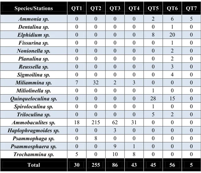
Analyses of foraminiferal assemblages from Cua Tung and Cua Viet estuaries, April 2017 ... 42
Analyses of samples from Cua Tung and Cua Viet estuaries, September 2017 ... 46
Analysis of environmental data 2006-2018 ... 58
Discussion on characteristics of lagoon and estuarine environments of Central Vietnam ... 60
Climate of Central Vietnam ... 60
Considerations on foraminiferal ecology ... 61
Tam Giang-Cau Hai lagoon physiography and ecosystems. ... 61
The Tam Giang Cau Hai sub-basins and active river system... 62
Tam Giang-Cau Hai lagoon hydrology. ... 63
Tam Giang-Cau Hai lagoon water chemistry... 64
Hydro-chemical characterization of the water masses and lagoon seasonality .... 67
Tam Giang-Cau Hai lagoon biocenotic mapping and distribution of main commercial species ... 71
Tam Giang-Cau Hai lagoon ecosystem zoning. ... 72
Non-living resources (soil, groundwater, mineral resources) ... 75
Summary and conclusions... 80
Assessment of status of coastal environment ... 80
Status of quality of coastal environment ... 80
The sources of environmental hazards, pollution and degradation in the coastal area ... 81
Critical issues relating to the quality of wetland habitats of Central Vietnam ... 83
Vulnerable ecosystems in Tam Giang-Cau Hai lagoon and coastal areas and risk assessment maps. ... 83
Assessment of status of coastal biological resources ... 85
References ... 90
Annexes ... 96
Annex 1 – Comprehensive datasets of surveys 2006-2013, secondary data considered in this synthesis ... 96
Annex 2 – Comprehensive datasets of surveys 2015-2018, primary data collected during the implementation of this PhD project. ... 142
List of Figures
Figure 1 – Geography and political boundaries (communes) of the Tam Giang-Cau Hai lagoon and its surrounding territory. The whole Tam Giang-Cau Hai lagoon belongs to the Thua Thien Hue Province; the 33 riparian communes belong to five districts. In the insert, the location of the Province and the Tam Giang-Cau Hai lagoon in the National context. ... 21 Figure 2: Location of Quang Tri Province and related river network ... 29 Figure 3 - Sampling stations in Quang Tri Province, April 2017. ... 32 Figure 4 - Van Veen grab (left), Van Dorn sampler (center) and 50-mL-capacity Falcon conical tubes (right). ... 33 Figure 5 – Diagram showing a generalized foraminfer life cycle. Note the alternation between a haploid megalospheric form and a diploid microspheric form (redrawn after Goldstein, S.T., 1999). ... 40 Figure 6 - Formation of new chamber and laminate structure in perforate foraminifera. (Erez, J., 2003, reprinted by Cusak, M., and Freer, A., 2008). ... 40 Figure 7 - Model for temporal fusion of the seawater vacuoles (SWV) with the plasma membrane (pm) near the active calcification site. Seawater enters the cell through deep invaginations or semi-open vacuoles (sov). A vacuole is pinched off and undergoes alkalization by one of the cellular proton transport mechanisms. This SWV concentrates inorganic carbon by diffusion of CO2 (aq) from the acidic cytosol into the alkaline SWV.
This process is enhanced by adjacent mitochondria (m) and by the acidic vesicles (av) that release CO2. The [Ca2+] and [CO32−]-enriched vacuoles fuse with the cell membrane and
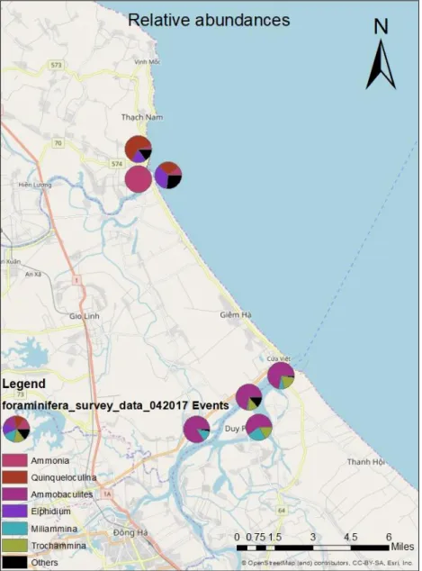
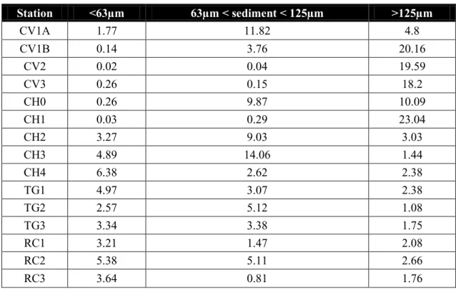
supply the ions for calcification. The vacuoles are then resealed and release their content apically, away from the growing crystals (after Bentov, S., et al. 2009). ... 41 Figure 8 - Relative abundances of the main living benthic foraminifera genus in Cua Tung and Cua Viet estuaries, Quang Tri Province, April 2017 ... 43 Figure 9 - Percentage of foraminifera species in Cua Tung (QT5, QT6, QT7) and Cua Viet (QT1, QT2, QT3, QT4) estuaries, Quang Tri Province. Survey April 2017. TC, total calcareous; TMC, total Miliolids calcareous; TA, total agglutinated ... 44 Figure 10 - Proportion of tests of living benthic foraminifera in Cua Tung and Cua Viet estuaries, Quang Tri Province, April 2017 ... 45
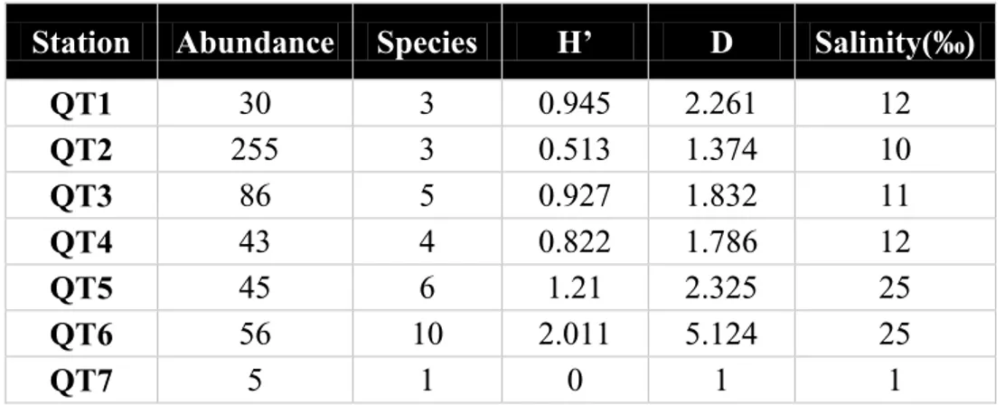
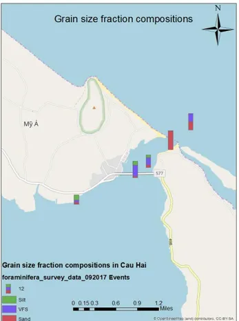
Figure 11 - Correlation between salinity and benthic foraminiferal diversity (richness) in samples from Cua Viet and Cua Tung estuaries, Quang Tri Province, Survey April 2017 ... 46 Figure 12 - Sediment grain-size variations in 15 stations within 4 sampling areas ... 47 Figure 13 - Grain size fraction compositions in samples from the Cau Hai inlet (Thua Thien Hue Province) ... 48 Figure 14 - Grain size fraction compositions in Tam Giang ... 48 Figure 15 - Grain size fraction compositions in Cua Viet ... 49 Figure 16 – Relative abundances of the main living benthic foraminifera genus in Cua Viet estuary, Quang Tri Province, September 2017 ... 53 Figure 17 – Relative abundances of the main living benthic foraminifera genus in Tam Giang lagoon, Thua Thien Hue Province, September 2017 ... 53 Figure 18 - Relative abundances of the main living benthic foraminifera genus in Cau Hai lagoon, Thua Thien Hue Province, September 2017 ... 54 Figure 19 - Percentage of foraminifera species from samples from Cua Tung and Cua Viet estuaries of Quang Tri Province, Tam Giang-Cau Hai lagoon, Thua Thien Hue Province. TC, Total Calcareous; TMC, Total Miliolids Calcareous; TA, Total Agglutinated. ... 54 Figure 20 – Proportion of tests of living benthic foraminifera in Cua Viet estuary, Quang Tri Province, September 2017 ... 55 Figure 21 – Proportion of tests of living benthic foraminifera in Tam Giang lagoon, Thua Thien Hue Province, September 2017 ... 56 Figure 22 - Proportion of tests of living benthic foraminifera in Cau Hai lagoon, Thua Thien Hue Province, September 2017 ... 56 Figure 23 - Percentage of foraminifera species from samples from Cua Tung and Cua Viet estuaries of Quang Tri Province, Tam Giang-Cau Hai lagoon, Thua Thien Hue Province. TC, Total Calcareous; TMC, Total Miliolids Calcareous; TA, Total Agglutinated. ... 57
Figure 24 - Correlation between in salinity and benthic foraminiferal diversity (richness) of Cua Tung and Cua Viet estuaries of Quang Tri Province and of Tam Giang-Cau Hai lagoon, Thua Thien Hue Province. ... 58 Figure 25 - The Tam Giang-Cau Hai lagoon sub-basins and their tributary river network. From northwest, the O Lau river discharging into the Tam Giang-Cau Hai lagoon; the Bo and Huong rivers, directly discharging into the Eastern Sea though the Thuan An inlet and the Truoi river, discharging into the Cau Hai sub-basin. ... 62 Figure 26 – Diffusion and dispersion of the spots during the first 48 hours of simulation,forced by the astronomical tide of April 2011. ... 65 Figure 27 - Results of cluster analysis of environmental parameter (dissolved oxygen, pH, salinity and temperature) for the four surveyed seasons of 2006 (April, spring; May, dry season; August, beginning of rainy season; November, rainy season but unusually dry in 2006). Cluster description is: 1, fresh water characterized by very low salinity (1 psu), lowest pH (except November), highest DO in early spring and fall and lowest, in summer (May and August); 2, low-salinity (average 7.8 psu) inner-lagoon water, as low as 3.5 psu during rainy months of April and August and as much as 13 psu in dry months of May and November; pH fluctuates between 7.5 during rainy months and 8.1 during dry month; 3, low-salinity brackish water, with intermediate salinity values ranging from 10 and 19 psu, lowest dissolved oxygen concentration and pH higher than 8; 4, low-salinity brackish waters, with stable salinity of 14 psu, temperature above 30 degree, pH average around 8 and concentration of dissolved oxygen systematically higher than cluster 3 (in excess of 7 mg/l). During the driest month of May, these intermediate waters are indistinguishable from those of cluster 5; 5, typical brackish water with salinity ranging between 16 and 18 psu, temperature normally higher than 30 degrees and average pH around 8. The concentration of dissolved oxygen is higher than 7 mg/l and salinity raised over 22 psu during driest month of May; 6, cooler marine waters (average 26.5 °C in April; lower than cluster 6); 7, marine waters, with salinity higher than 20 psu, as much as 30 psu during the dry months of May and November; temperature between 28,5 and 30,5 °C. Lowest concentration of dissolved oxygen in November, similarly to cluster 3. ... 69
Figure 28 - Natural and anthropic habitat distribution of Tam Giang-Cau Hai. Legend: 1, hydrophytes prairies; 2, sea grass fields; 3, aquaculture ponds; 4, tidal flats; 5, sandy-mud lagoon floor; 6. sandy-muddy lagoon floor; 7, meadows flooded in the rainy season. .... 71 Figure 29 - Distribution map of characteristic Tam Giang-Cau Hai biota and selected commercial species (natural fish population, macrophytobenthos, macrozoobenthos). Legend: 1, Meretrix sp. (Trìa), fresh-water shrimps, fresh-water weeds; 2, Meretrix sp. (Trìa), sea crab, thorned black crab (ram), Potunus sp. (blue crab or ghe); 3, Saccostrea
sp., Meretrix sp. , Cerithidea; 4, Meretrix sp., Potunus sp. (blue crab or ghe),
fresh-water Tilapia, Siganus, sea fishes; 5, Meretrix sp., Potunus sp. (blue crab or ghe), seagrass, Veneridae and others bivalves, Corbicula, Siganus, Metapenaeus ensis, shrimps (tôm go mo); 6, Cerithidae (ôc), seaweeds; 7, Cerithidae (ôc), Corbicula, seaweeds; 8, Solen sp., Metapenaeus sp., Cerithidae; 9, Corbicula, Portunus (blue crab or ghe), Pteria, Saccostrea, Penaeidae. ... 72 Figure 30 - Integrated ecosystem zoning map derived from the distribution of water body characteristics (cluster analysis), lagoon-bottom features, sediment types and selected biota compositions (legend for fields a-I, see Fig. 29). Ecosystem legend: 1, Upper Tam Giang, O‘ Lau eco-zone; 2, Central Tam Giang, distal O‘ Lau eco-zone; 3, Lower Tam Giang zone; 4, Huong river inner delta zone; 5, Sam Chuon eco-zone; 6, Upper Thuy Tu marine relic waters; 7, Lower Thuy Tu channel and western Cau Hay continental domain; 8, Eastern Cau Hai marine and submarine domain, including mixing zone. The lower Tam Giang, the Sam Chuon and eastern Cau Hai show affinities in the way of having low-dynamic, stagnant water masses, largely of continental origin ... 73 Figure 31 - Simplified land-use map of the territory surrounding the Tam Giang-Cau Hai lagoon. Legend: 1, agricultural areas (rice paddies and cultivated fields) in alluvial plain lowland; 2, aquaculture areas, potential sites of effluent waste-water discharge and sources of organic pollutants (fish feeds, fish metabolism residues etc.); 3, urban (and industrial) areas; 4, semi-natural tropical and subtropical moist broadleaf forests; 5, semi-natural sandy area, with irregular and discontinuous bush coverage; 6, inland waters and sea. ... 76 Figure 32 - Land use/land cover categories and nomenclature defined for coastal Thua Thien Hue Province, modified after CORINE land types classifications. ... 77
Figure 33 - Cartoon showing a typical example of coastal phreatic aquifer from sand dunes. ... 79 Figure 34 - Hazards classification for the Tam Giang-Cau Hai and the coastal province of Thua Thien Hue. The time scale indicates the time frame and frequency at which hazard may turn into an emergency. ... 81 Figure 35 - Zoning map of the Tam Giang-Cau Hai lagoon based on risk-level towards fishery activities, as assessed in 2004, and range of proposed interventions in support of the sector (as per Decision No. 3677/QD-UB of 2004 of the Thua Thien Hue Provincial People‘s Committee). ... 84 Figure 36 - Risk maps of the Tam Giang-Cau Hai lagoon representing the risk level evaluated for each of the identified ecosystems (above) and communes (below). Risk levels have been ranked according to three categories: 1, low, whenever emergencies are mild and their effects are likely to be naturally mitigated or nullified in the short term; 2, moderate, whenever emergencies, once they manifest, are circumscribed or controllable and 3, high, whenever emergencies are persistent and/or multiple emergencies can manifest simultaneously. ... 85 Figure 37 - Percent of species distribution in Tam Giang-Cau Hai lagoon identified during the assessments 2006-2018. ... 86 Figure 38 - Distribution of number of aquatic species in the Tam Giang-Cau Hai lagoon sub-basins. ... 89
List of Tables
Table 1 – Parameter measuring and detection methods ... 34 Table 2 - Foraminifera species abundance each station in Cua Viet, Cua Tung estuaries, Quang Tri Province - Survey April 2017... 42 Table 3 - Diversity of foraminiferal species from samples of Cua Tung and Cua Viet estuaries, Quang Tri Province, survey April 2017. H‘, Shannon-Weiner Diversity Index; D, Simpson Diversity Index ... 45 Table 4 - Grain-size fraction compositions ... 47 Table 5 - Foraminifera species abundance from samples from Cua Tung and Cua Viet estuaries of Quang Tri Province, Tam Giang-Cau Hai lagoon, Thua Thien Hue Province ...52 Table 6 - Diversity of foraminiferal species of Cua Tung and Cua Viet estuaries of Quang Tri Province, Tam Giang-Cau Hai lagoon, Thua Thien Hue Province. H‘, Shannon-Weiner Diversity Index; D, Simpson Diversity Index ... 57 Table 7 - Production per catch session (in tons per hectare) and extrapolated bulk biomass (in tons), May 2006. ... 89
List of Acronyms
BOD Biological Oxygen Demand
DANIDA Danish International Development Agency
DO Dissolved Oxygen
ES Ecosystem Services
FAO Food and Agricultural Organization FOBIMO Foraminiferal Biomonitoring
GoV Government of Vietnam
GPS Global Positioning System
ICZM Integrated Coastal Zone Management ISQG Interim Sediment Quality Guidelines
IUCN International Union for the Conservation of Nature IUU Illegal, Unregulated and Unreported
IWRM Integrated Water Resources Management
MEA Millennium Ecosystem Assessment
MSC Monitoring, Surveillance and Control NGO Non-Governmental Organizations
OC Organic Compound
PEL Permissible Exposure Limit TCVN Technical Committee of Vietnam
TEEB The Economics of Ecosystems and Biodiversity
TN Total Nitrogen
TP Total Phosphorus
US EPA United States Environmental Protection Agency
UN United Nations
Abstract
The objective of this thesis is to systematize the environmental datasets acquired during a period of nearly two decades at set locations in Tam Giang-Cau Hai lagoon of Thua Thien Hue and Quang Tri Provinces, integrating existing secondary datasets with newly acquired primary information during 2006-2018.
In addition to physico-chemical parameters, biological proxy indicators of ecosystem integrity were incorporated in the database, in attempt to develop a tool-box methodology to reveal the degree of effectiveness of lagoon and wetland ecosystem functions being, long-term and seasonal variations and the degree of environmental stress caused by human activities.
Coastal plains and wetlands have been privileged sites for human civilizations for millennia. Their habitats and resources have been critical to the development and survival of humanity. Wetland ecosystems are part of our natural assets, providing services worth trillions of US dollars every year and making a vital contribution to life. With increasing demographic pressure and modern society craving for water and food resources, not counting threats posed by climate changes, the need to maximize these benefits has never been greater or more urgent.
A fundamental issue in developing countries is to harmonize environmental conservation and social progress. Human conditions are tightly linked to the state of the environmental where economic activities and social life are carried out. The Millennium Ecosystem Assessment stemmed from the assumption that a close relationship between welfare and prosperity of a community, its security and resilience is related in a multi-faceted way to the salubrity of the environment and its effectiveness in performing functions and providing services supportive to human life.
The following approach has been followed to set up a framework for the implementation of developmental projects or the drafting of ecosystem-based management policies and plans aiming at both environmental conservation and human well-being:
Inventory of ecosystems and habitats in a specific locale
Development of a set of objectively verifiable and quantifiable indicators to appraise the state of ecosystems, their effectiveness in performing functions and
delivering services.
Establish a science-based framework for environmental monitoring and data acquisition for use of scientists and policy makers
Establish a GIS-based environmental relational database to serve the purpose of planning, management and policy drafting.
Develop thematic mapping for planning, tracking environmental changes, land use, soil consumption, illegality and abusive encroachment of urban settlements onto wetland.
Use remote-sensing techniques to extrapolated point-source information to land and water surfaces
A methodology for each of these components is delivered as output of this thesis, then integrated into an operational tool-box for use of managers and decision makers.
The Tam Giang-Cau Hai lagoon with its 22,000 hectares of water surface and estuary wetlands, with associated deltas and forests, represent the largest lagoon system in Southeast Asia. It is a key area that, as a consequence of post-war rural repopulation, demographic increase, resource overuse, urbanization and industrialization, has undergone substantial changes in the past two decades.
As a consequence of human pressure and encroachment of the natural habitats, there is a perception that ecosystem functions and services have been impaired; however, a clear and science-grounded understanding to what extent the beneficial effects to the riparian communities has been compromised.
This doctoral thesis has been conceived with the objectives of developing a methodology for a science-based analysis of environmental effectiveness and ecosystem-service provision based on:
available and routinely acquired data,
standardization, spatialization and consistency assessment of available information,
ecosystem and habitat identification,
assessment of resource state and trends
tool development for data dissemination
The environmental degradation of the Central Vietnam wetlands and increasing pressure on their aquatic resources, together with typhoons, floods and droughts that
yearly strike the province concurred in creating a situation of particular vulnerability for people living on and around it. This situation of persistent threat and creeping decline has been a matter of concern in the past two decades: the application of the methods of science in support of environmental monitoring and control will contribute to a more effective management of the locale in the long term.
Original datasets were collected, in the years 2015-2018, according to a protocol, laboratory procedures and sampling grid compatible with previous campaigns implemented in 2006-2013 whose data are available from the local literature and internal Provincial reports.
A substantial component of the study was dedicated to benthic foraminifera, specific taxonomic category considered of importance as indicators of environmental quality and stress.
In order to assess water quality, the following list of parameters were measured, both directly in the field during sample collection and in the laboratory.
Water depth of station,
Turbidity,
Temperature,
Flow velocity during tidal flood and ebb,
Compositional and textural parnameters of bottom sediments,
Total solid and suspended solid present in the water,
pH,
Saliniity,
Dissolved oxygen,
Nitrites and nitrates,
Ammonia, Alkalinity, Total phosphorous, Total nitrogen, Chlorophyll A Zoobenthos biomass Phytoplankton
Microalgae and toxic algae
Total coliforms, E. coli and Vibrio cells
The focus of the thesis is hinged on the assumption/observation that benthic foraminiferal assemblages display an overly sensitivity to environmental changes. The rationale of the investigation is therefore based on a threefold approach:
Comparative analyses of historical time series of environmental data over the period of a decade.
Relationships between environment parameter changes and shifts in the composition of foraminiferal assemblages.
Calibration of foraminifera assemblages as a predictive tool for upcoming environmental changes.
Findings of this dissertation are:
The Tam Giang-Cau Hai and wetlads of Central Vietnam maintain their rather pristine state compared to other lagoon and deltaic settings of the world, despite the high population density, the strong demand for food resources and on going vigorous development. Historical events of the second half of the past century slowed down the process of industrialization and urbanization, maintaining agriculture and fishery into artisanal conditions and the aesthetic of the natural environment into its untouched beauty.
Aquaculture has been another major element of perturbation of the natural system: the attempt to promote shrimp production in the nineties generated in cascade negative impacts whose repercussions are still felt today: widespread organic pollution, wiping out of endemic mangrove ecosystem, eliminating inter-subtidal spawning and nursery platform, loss of productivity, break of reproductive cycle of numerous species, loss of biodiversity, hindrance of circulation etc.
Critical issues relating to the quality of wetland habitats of Central Vietnam
Parameters and variables of water quality, sediments, benthic associations in Tam Giang-Cau Hai lagoon and estuaries of Central Vietnam portray a rather stable situation and a persistent acceptable standard for aquaculture; however, high organic-matter input to open waters relating to biological excretion and excessive feed may create eutrophication and anoxia lethal for life.
High-impact shrimp monoculture is unsustainable on the long term: alternative methods (e.g. clam farming) need to be studied and piloted to mitigate negative effects of effluents and aquaculture waste waters.
Livelihood shift is necessary, having short-term impact on household welfare and economy, but unquestionably beneficial on the long term.
Need of a viable community-based solid-waste collection and treatment plan, including the creation of a community-based collection network at commune level.
Appropriateness of the future implementation of a wetland ecosystem carrying capacity exercise, in support of future planning and zoning for conservation and exclusion
Need of a water-quality monitoring system for early warning of upcoming critical conditions and implementation of protection measures.
Biodiversity is an asset of Central Vietnam wetlands. In terms of species richness, these far outnumber any other lagoon in Vietnam and in the world. Count totals approximately 1000 species, most of them systematically identified: phytoplankton records the highest in number of representative species (287), fish‘s species are 215-230; birds, 73; zooplankton, 72; zoobenthos, 193 species, seaweeds 46, higher plant, 31; water grass 18 (of which 7 species of sea grass).
High biodiversity depends on physiographic complexities, diversity of habitats, and seasonal changes of the aquatic environment: salinity fluctuations between the dry and rainy season affect the composition of biota and species predominance.
Riassunto
L'obiettivo di questa tesi è stato quello di creare e sistematizzare set di dati ambientali acquisiti durante quasi due decenni in siti costieri del Vietnam Centrale, (laguna di Tam Giang-Cau Hai) nelle Provincie di Thua Thien Hue e Quang Tri.
Oltre ai parametri fisico-chimici, nel database sono stati inclusi indicatori biologici di integrità dell'ecosistema, nel tentativo di sviluppare un prontuario e linee guida per rivelare il grado di efficacia delle funzioni e dei servizi ecosistemici offerti dagli ambienti lagunari e zone umide
Le pianure costiere e le zone umide offrono habitat e risorse naturali fondamentali per lo sviluppo e la sopravvivenza dell'umanità. Gli ecosistemi delle zone umide costiere offrono all‘ uomo risorse naturali e servizi per un valore di trilioni di dollari ogni anno e apportando un contributo fondamentale alla prosperità delle comunità rivierasche. Con l'aumento della pressione demografica e la società moderna che brama acqua e risorse alimentari, la necessità di massimizzare questi benefici non è mai stata così grande o urgente.
Nei paesi in via di sviluppo è fondamentale l'armonizzazione della conservazione ambientale e del progresso sociale. Le valutazioni del Millennium Ecosystem Assessment sono basate sul presupposto che esista una stretta relazione tra benessere e prosperità di una comunità e la sua sicurezza e resilienza: queste due condizioni sono strettamente legate alla salubrità dell'ambiente, alla sua efficacia nello svolgimento di funzioni indispensabili all‘uomo e alla fornitura di servizi di supporto alla vita.
Il seguente approccio è stato seguito per istituire un protocollo di analisi ambientale • Inventario degli ecosistemi e degli habitat.
• Sviluppo di indicatori oggettivamente verificabili e quantificabili per valutare lo stato di salute degli ecosistemi,
• Costruzione di un database relazionale ambientale a base GIS per scopi di pianificazione e gestione.
Introduction
Despite awareness and concern on environmental integrity has increased over the recent decades, wetlands are largely considered in both developing and developed countries as wasteland, unusable territory to be preferably drained and converted for development and other land uses.
Over the past century more than half the acreage of coastal wetlands and lagoons have been lost through reclamation and converted into arable land and/or urban areas. A fraction of natural wetland have undergone degradation because of human encroachment aiming to resource utilization and land occupation, such that ecosystems relying on freshwater availability are in major decline. Demographic increase and demand for water and food causes additional pressure on wetland ecosystems and as wetlands are degraded, communities struggle for subsistence, insecurity and poverty. Since the early years of this century, Vietnam has undergone a vigorous process of economic development accompanied by aggressive land occupation and soil consumption, to accommodate infrastructures, urban expansion and industrialization. Given the geography of the country, whose population primarily concentrates on a narrow coastal stripe, embayments, coastal lagoons, wetlands and archipelagos were all to a various extent affected.
The Tam Giang-Cau Hai lagoon of Central Vietnam is a paradigm of such process of degradation, fueled by economic development, demographic increase after countryside re-population, resources overuse, deforestation and water-surface occupation by aquaculture.
Concern over the sustainability of resource use of the Tam Giang-Cau Hai lagoon raised in the late nineties when signs of depletion of fishery and loss of biodiversity became evident as a consequence of negative impact of wetland forest eradication, aquaculture development and population increase. In those years, a number of international agencies (FAO, DANIDA, World Bank, Asian Development Bank, IUCN) and a number of National cooperation agencies bilaterally intervened in support of sustainable resource use and food security in this area and elsewhere in the country.
In the years between the 2001 and 2005, the Millennium Ecosystem Assessment program was launched to appraise the consequences of the changes in the ecosystem‘s
structure and modifications of natural habitats affecting human well-being and to establish sound approaches and scientific methodologies for initiatives required to promote environmental conservation, sustainable use of resources and maintain the integrity of those functions that ecosystems perform ultimately and intimately contributing to societal welfare.
In the early 2000‘ IUCN supported the concept of Integrated Water Resource Management in the Huong River basin, whose the Tam Giang-Cau Hai lagoon is the seaward termination, in the attempt to balance ‗environmental flows‘ in the whole catchment area subjected to diverse and contrasting needs (hydro-power, sand mining, water transportation, urbanization, agriculture, fishery and aquaculture in its downstream side. The concept of ‗environmental flows‘ implies the application of appropriate policies and management measures to ensure that water resources are equitably shared in a catchment, in an appropriate way to maintain downstream ecosystems and services unaltered. Creating an environmental flow regime is an important foundation of Integrated Water Resources Management (IWRM).
Understanding the complexities of coastal marine and wetland ecosystems, in 2005, an FAO rural development project entered on duty in the Tam Giang-Cau Hai lagoon, applying the concept of integrated coastal zone management (ICZM) not just to water but to all resources being utilized by the riparian communities (fishery, forestry, agriculture), in the attempt to regulate their use and ensure a sustainable food supply in the long term. For the first time, the concept of ecosystem management was applied and a cross-sectorial, holistic approach was used to delineate a management system of the largest lagoon system in Southeast Asia, compatible to the multi-faceted needs of the communities of resource users.
In compliance with the spirit of Millennium Ecosystem Assessment, the development of scientific basis to evaluate the integrity of Tam Giang-Cau Hai lagoon ecosystems was piloted by the FAO project in the years 2005-2102, in the attempt to develop a relational database of environmental standardized parameters usable as a baseline by the Provincial technical departments for support to decision making.
Objective of this thesis
The FAO-supported project carried out extensive monitoring in the Tam Giang-Cau Hai lagoon during the years 2006-2012. The scope of data collection and storage related to the concept of linking the ability of an ecosystem to effectively maintain its functions unaltered (and therefore to ensure services to the human communities living on it) to a set of objectively detectable and verifiable parameters, as reference values to be used in monitoring.
Given the socio-economic focus of the FAO-supported project, the science-based approach to ecosystem management remained at a piloting stage, yet providing substantial data series to be elaborated further and contributing to an assessment of ecosystem functionality.
The objective of this thesis is to systematize the environmental datasets acquired during a period of nearly two decades at set locations in Tam Giang-Cau Hai lagoon of Thua Thien Hue and Quang Tri Provinces, integrating existing secondary datasets with newly acquired primary information during 2006-2018.
In addition to physico-chemical parameters, biological proxy indicators of ecosystem integrity were incorporated in the database, in attempt to develop a tool-box methodology to reveal the degree of effectiveness of lagoon and wetland ecosystem functions being, long-term and seasonal variations and the degree of environmental stress caused by human activities.
GIS-data spatialization will specifically locate sites/zones requiring attention, supporting a proactive approach to remediation, enhanced resilience, sustainable utilization of environmental resources and balanced development in a climate of aggressive urbanization and industrialization of the country.
Why wetlands matter
Coastal plains and wetlands have been privileged sites for human civilizations for millennia. Their habitats and resources have been critical to the development and survival of humanity. Our progress in science and technological may support the misconception that nature can be ultimately controlled, but recurrent catastrophes rooted in an unsustainable use of land and water suggest that human society still depend on properly functioning ecosystems.
Wetland ecosystems are part of our natural assets, providing services worth trillions of US dollars every year and making a vital contribution to life. With increasing demographic pressure and modern society craving for water and food resources, not counting threats posed by climate changes, the need to maximize these benefits has never been greater or more urgent.
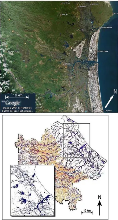
Figure 1 – Geography and political boundaries (communes) of the Tam Giang-Cau Hai lagoon and its surrounding territory. The whole Tam Giang-Cau Hai lagoon belongs to the Thua Thien Hue Province; the 33 riparian communes belong to five districts. In the insert, the location of the Province and the Tam Giang-Cau Hai lagoon in the National context.
Wetlands exist where superficial waters encroach over land; there mangroves forests, peatlands, salt marshes, streams, ponds and lakes, but also deltaic expanses, floodplains and flooded forests develop. Coastal wetlands occur where rivers meet the sea, water flow slows and expands into lagoons, embayments and shallow waters. Agriculture is practiced extensively in coastal wetlands, such as rice paddy fields and orchards, to a various extent altering the natural landscape.
Rivers convey fertile sediments to the sea, building-up floodplains that support agriculture. Rivers and estuaries are waterways facilitating maritime commerce and transportation; rivers are source of energy and drinking water for vast regions on Earth. River-related wetlands provide critical habitat for fishes and other aquatic animals vital for humans as food and proteins.
Deltaic swamps, lagoons and estuaries control and regulate water supply and quality to the most densely populated areas of the planet. Water risks to society, including scarcity, droughts and floods, are mitigated at wetlands, whose conservation and restoration is a cost-effective investment towards water security.
Wetland (mangrove) forests thrive in tropical and sub-tropical wetlands. These complex ecosystems develop under saline conditions unsuitable to most forest formations. Besides being nursery to a vast range of aquatic creatures, providing nutrients to nourish plankton, algae and fishes, mangrove forests offer physical protection against climatic extremes such as typhoons, storm winds and related floods. Dense mangrove forests may absorb and abate the destructive force of storm surge being an effective mitigation measure against weather deterioration due to climate changes. Moreover, mangroves are among the most effective carbon storage systems on Earth.
Background
A fundamental issue in developing countries is to harmonize environmental conservation and social progress. Human conditions are tightly linked to the state of the environmental where economic activities and social life are carried out. The Millennium Ecosystem Assessment stemmed from the assumption that a close relationship between welfare and prosperity of a community, its security and resilience is related in a multi-faceted way to the salubrity of the environment and its effectiveness in performing functions and providing services supportive to human life.
Since the early 2000‘, the concept of ecosystem-based management was reflected into policy papers, management regulations and plans, in such a way that the focus was shifted from human actions and economic activities solely, to broader spectrums of initiatives promoting conservation and rehabilitation of ecosystems as a whole.
The concept of ecosystem management pioneered by the FAO developmental project in Tam Giang-Cau Hai lagoon designed its implementation strategy to achieve both ecological and social progress, by blending environmental science, monitoring and community development, without detracting from its primary objective that was food security and poverty alleviation.
An analysis of World Bank projects with objectives of alleviating poverty and protecting biodiversity revealed that only 16% made major progress on both objectives. The approach developed in this thesis relates to the delivery of a framework in which a detailed exploration of science data and social economic achievements in a specific area are conducive to balance biodiversity conservation and social progress as a result of how people manage their ecosystem services.
Scientific advances around ecosystem functions and ecosystem service production and the design of appropriate monitoring programs are pivotal for the implementation of conservation and developmental objectives that will successfully advance both environmental and social goals.
In the early days, the Millennium Ecosystem Assessment endeavor exposed huge gaps in what later became known as science of ecosystem services. Yet, many development projects of those days embodied both aspects, recognized as intimately related by both conservationists and developmental agencies, of stewardship of nature, biodiversity conservation and economic development.
The results were a series of developmental initiatives, especially in the Tam Giang-Cau Hai lagoon, with integrated conservation and development purpose, all justified by the assumption that nature provides human communities with benefits and poverty and environment degradation and the ―two sides of the same coin‖.
Understanding the constraints that influence the outcomes of projects with dual conservation and economic development goals is crucial. One possible approach is to elaborate an investigation framework to be applied for assessing the connections
between ecosystem services and economic development, by adopting indicators and metrics that could increase the likelihood of concurrent positive outcomes (win-win) in both interconnected aspects of natural and social life.
A framework linking environmental science to human welfare.
There are two possible approaches by which the science of ecosystem services can contribute to biodiversity and environmental integrity as well as to social welfare, economic progress and poverty alleviation.
One strategy is to promote economic viability of activities deriving from the effectiveness of services delivered by a specific ecosystem, in such a way that these activities may generate additional income and, in the best case, promote investments whose profits could be utilized to compensate eventual loss of economic opportunities suffered by communities engaged in environmental conservation.
In this case, the full accounting of ecosystem services available and a better insight on how and rater at which theses services are delivered, and economic value attached to them, might be an incentive to pay for nature conservation.
The second approach relates to the internalization of benefits deriving from the ecosystem management, by fostering a community-based economy through promotion of rural industries and access to the market of those goods (e.g. organic produce) and resources (e.g. touristic offer) whose availability is enhanced by the adoption of better environmental conservation practices.
When the economic value of natural ecosystems and resources are explicitly quantified, benefits are more valued both by the people who directly interact with the ecosystems and/or (government) agencies that would have to financially contribute from substitute sources, should ecosystems become impaired.
Whichever strategy is adopted, the following investigation steps should be undertaken to set up a framework for the implementation of developmental projects or the drafting of ecosystem-based management policies and plans aiming at both environmental conservation and human well-being:
Development of a set of objectively verifiable and quantifiable indicators to appraise the state of ecosystems, their effectiveness in performing functions and delivering services.
Establish a science-based framework for environmental monitoring and data acquisition for use of scientists and policy makers
Establish a GIS-based environmental relational database to serve the purpose of planning, management and policy drafting.
Develop thematic mapping for planning, tracking environmental changes, land use, soil consumption, illegality and abusive encroachment of urban settlements onto wetland.
Use remote-sensing techniques to extrapolated point-source information to land and water surfaces
A methodology for each of these components is delivered as output of this thesis, then integrated into an operational tool-box for use of managers and decision makers.
Practical applications of the methodology and use of the toolbox is to adopt a scientific approach based on objectively verifiable indicators to ecosystem assessments and effectiveness of ecosystem functions and services supporting human life and community‘s well-being.
Ecosystem functions and services
Ecosystem functions are natural process that take place in animal and plant communities of the different biomes through exchanges of energy and nutrients in the food chain which are vital to the sustenance of plant and animal life on the planet. Ecosystem services are ecosystem functions that are directly beneficial to humans. These concepts evolved from the vast literature flourished on the subject, dating back since the sixties and seventies (King, 1966; Neef, 1966; Van Der Maarel and Dauvillier, 1978) and exponentially grown in the nineties (De Groot, 2002) detailing with increasing precision the roles natural ecosystems have in supporting human life and improving capacity to cope with adverse (natural, economic, societal) events (i.e. ―resilience‖ in modern terms).
The ―ecosystem service‖ concept has evolved though time to attain its modern significance of a multi-layered approach at the interface between ecosystems and human well-being.
Daily (1997) defines ecosystem services as ―the conditions and processes through which natural ecosystems, and the species that make them up sustain and fulfill human life‖. Costanza et al., 1997 and Millennium Ecosystem Assessment (2005) provide further predications as ―benefits human populations derives, directly or indirectly from ecosystem functions.
Boyd and Banzhaf (2007) put emphasis of ―consumption or utilization‖ of ecological components (i.e. resources, tangible or intangible such as landscape) for the purpose of achieving ever increasing human well-being. TEEB (2009) and Fisher et al., (2009) follow the same line of reasoning, whilst U.S. EPA (2008) focuses on the concept of sustainability defining ES as ―products of ecological functions or processes that directly or indirectly contribute to human well-being, or have the potential to do so in the future‖.
Ecosystem services are susceptible to human abuse when natural processes are impaired or excessive resources are withdrawn to sustain a growing population. Therefore, the nature of these ecosystem services and how these are sustained should be understood.
Classification of ecosystem functions and services
The Millennium Ecosystem Assessment (MEA) document provides a framework for understanding and assessing the benefits that ecosystems deliver to communities. According to it, services are grouped into four categories:
Supporting services. These include basic functions, such as nutrient recycling, primary production or soil formation, not directly beneficial to humans but indispensable to support ecosystem effectiveness and capacity to deliver the services of the other categories. TEEB replaced "supporting services" of the MEA document with "habitat services" defined as "ecosystem functions … a subset of the interactions between ecosystem structure and processes that underpin the capacity of an ecosystem to provide goods and services"
Provisioning services relate to the production of commodities usable by humans as food, raw materials (e.g. lumber, fuel, etc.), genetic resources, water and energy, but
also biogenic minerals, medicinal and ornamental resources.
Regulating services relate to the role ecosystems play in altering/regulating natural and biological processes, or even planetary cycles such as climate, carbon cycle etc. Pollination is a basic regulating service, but also carbon sequestration, crucial in climate regulation, flood control, waste decomposition and detoxification, purification of water and air, pest and disease control.
Cultural services pertain to the spheres of aesthetics, spiritual life, history, support to education (school excursions) and recreational activities, such as ecotourism and sports).
The pilot study area and project justification.
The Tam Giang-Cau Hai lagoon with its 22,000 hectares of water surface and associated wetlands, deltas and forests, is the largest lagoon system in Southeast Asia. It is a key area that, as a consequence of post-war rural repopulation, demographic increase, resource overuse, urbanization and industrialization, has undergone substantial changes in the past two decades.
As a consequence of human pressure and encroachment of the natural habitats, there is a perception that ecosystem functions and services have been impaired; however, a clear and science-grounded understanding to what extent the beneficial effects to the riparian communities has been compromised.
Initiatives by international organizations (FAO, IUCN), NGOs, bilateral donors and the GoV have been promoted with the objectives of reverting trends of environmental degradation, primarily with a focus to poverty eradication, social and economic development but without a strategy and scientific information on how to restoring ecosystem functionality and protect ecosystem-service delivery to humans.
Environmental data have been collected extensively by governmental agencies and academic/research institutions, but databases hardly used for developing appropriate policies and undertaking management measured in support of environmental defense and resource conservation.
Objectives of the study
This doctoral thesis has been conceived with the objectives of developing a methodology for a science-based analysis of environmental effectiveness and ecosystem-service provision based on:
available and routinely acquired data,
standardization, spatialization and consistency assessment of available information,
ecosystem and habitat identification,
assessment of resource state and trends
tool development for data dissemination
Regional background and critical issues
The coastal zone of the Thua Thien Hue Province makes up 34% of its total area and about 81% of its population; it is where most economic activities are concentrated. The Tam Giang-Cau Hai lagoon, with its 68 km in length and 22,000 hectares of water surface is the largest lagoon in South East Asia. A community of over 300,000 people, mainly farmers and fishers, live on the resources of the water basin and its surrounding land. Administratively, thirty-three communes face the waters of the lagoon, grouped into five lagoon coastal districts, all under the Provincial authority of Thua Thien Hue. North of Thua Thien Hue lays Quang Tri Province, the natural continuation of this Central Vietnam wetland, lagoon and estuary complex spanning from Phu Yen to Quang Binh.
Figure 2: Location of Quang Tri Province and related river network
The Quang Tri province is located in a strategic area for transport and communication, at the junctions among the National Route 1A, the Ho Chi Minh Highway and the East-West Economic Corridor. Also the North-South Expressway and Coastal Highway. Located at the border-gate of Vietnam, Quang Tri is the focal node of the Indian Ocean and South China commercial traffic, terminal of the East-West Economic Corridor and the Mekong sub-region.
Quang Tri province has a total area of 4,592 km2 and a large river network that provides a suitable setting for aquaculture. The Quảng Trị province also has 55% area of the
mountainous territory and a 75-km-long coastline with a number of touristic destinations (Cửa Tùng, Cửa Việt, and Mỹ Thủy).
There are two major rivers: the Ben Hai river to north and the Thach Han river to the south, flowing into their own estuaries in Cua Tung and Cua Viet. The estuarine system in Quang Tri is complex because of the large number of tributaries draining the hinterland. In the estuaries, the salt water from the sea can invade up to 24 km inland creating a broad brackish zone of embayments, ox-bow lakes and wetlands.
The coastal belt is occupied by coastal dwellers; associated waterways and wetlands are being used for shrimp and fish farming (Trinh Q.T., 2010). Many local farmers shifted to shrimp culture because of high economic income from some successful models, but unplanned development of this industry brought up excessive pollution from untreated effluents, environmental deterioration and the prospect of unsustainable resource use. There is a clear need of environmental management for this extensive wetland and lagoon system and a latent need for management of the coastal and inshore marine fisheries as a whole. According to existing data and feedback from fishers, commune leaders and local knowledge, the main reasons for the need to manage the coastal zone in an integrated manner are:
The persisting degradation of the lagoon environment and ecosystems, because of overfishing, fish farming and deforestation.
A significant decrease in stock abundance and diversity caused by illegal, unregulated and unreported (IUU) fishing and lack of monitoring, surveillance and control (MSC).
A natural tendency to inlet siltation because of insufficient tidal draft.
The need to include communities in management.
The need to harmonize processes of urban expansion, water-surface and agricultural land tenure, industrialization and rural development.
The objective of this study is to provide decision makers scientific tools to revert the negative trends of the past decades that turned the lagoon into a livestock-depleted freshwater lake, polluted by untreated effluents, with most of its wetland habitats and wildlife endangered or vanished.
Two pilot area were selected in this stretch of Central Vietnam coastal zone: the Quang Tri estuaries and the Thua Thien Hue Tam Giang-Cau Hai lagoon Giang-Cau lagoon. The environmental degradation of the Tam Giang-Cau Hai lagoon and increasing pressure on its aquatic resources, together with typhoons, floods and droughts that yearly strike the province concurred in creating a situation of particular vulnerability for people living on and around it. This situation of persistent threat and creeping decline has been a matter of concern in the past two decades: the application of the methods of science in support of environmental monitoring and control will contribute to a more effective management of the locale in the long term.
Presentation of data
Original datasets were collected, in the years 2015-2018, according to a protocol, laboratory procedures and sampling grid compatible with previous campaigns implemented in 2006-2013 whose data are available from the local literature and internal Provincial reports.
Only selected datasets are discussed in the text, but the whole archive of information considered in this synthesis is given as Annex 1.
A substantial component of the study was dedicated to benthic foraminifera, specific taxonomic category considered of importance as indicators of environmental quality and stress.
Materials and methods
Methods of water and sediment samples collection
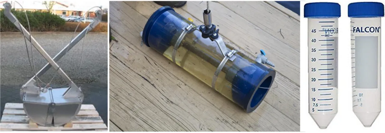
Water samples were collected using a bathometer at 3 depths: surface, mid-water and bottom layer. Sediment samples were collected using a Van Veen grab, wrapped in zinc foil. The water and sediment samples were stored at < 40C in the laboratory, before being analyzed.
Methods of phytoplankton sample collection
Phytoplankton samples were collected using a phytoplankton net with a 15 cm diameter and 45 cm length, and a mesh with a dimension of 20 m, in an area of 15-m radius at each station. Upon collection, phytoplankton samples were fixed with formol 4%,
transported to the laboratory and preserved at < 40C. Laboratory identification relied on morphological comparison method. Samples were analyzed with Olympus CH40 microscope with contrast phase.
Methods of sediment sample collection for foraminiferal studies
Samples were collected from the Tam Giang – Cau Hai lagoon in Thua Thien Hue Province and Cua Tung, Cua Viet estuaries in Quang Tri Province. Sediment and water sampling were collected using a Van Veen grab and Van Dorn sampler, respectively.
Figure 4 - Van Veen grab (left), Van Dorn sampler (center) and 50-mL-capacity Falcon conical tubes (right).
Sediment and water samples from each location were stored together in 50-mL-capacity BD Falcon Conical Tubes and transferred to the laboratory at the end of the day for storage in refrigerated chambers.
The positions of the sampling stations were determined and recorded as WGS84 latitude and longitude, using the Global Position System.
Water quality analyses
In order to assess water quality, the following list of parameters were measured, both directly in the field during sample collection and in the laboratory.
Water depth of station,
Turbidity,
Temperature,
Flow velocity during tidal flood and ebb,
Compositional and textural parnameters of bottom sediments,
Total solid and suspended solid present in the water,
pH,
Saliniity,
Dissolved oxygen,
Nitrites and nitrates,
Ammonia,
Alkalinity,
Total nitrogen,
Chlorophyll A
Zoobenthos biomass
Phytoplankton
Microalgae and toxic algae
Total coliforms, E. coli and Vibrio cells
Measuring methods are listed in the following Table 1.
Type of analysis Measuring method
Sediment Visual description and grain size analysis
Depth Measuring stick and ruler
Turbidity Sechi disk
Temperature Digital thermometer
Dissolved Oxygen (DO) Sera test kit
pH Sera test ki
kH Sera test kit
NH4+/NH3 Sera test kit
NO3 Sera test kit
NO2 Sera test kit
Salinity Optical salinometer
Total Solid (TS) Mass balance method (dried at 103–105°C) Suspended solids (SS) Mass balance method (dried at 105°C). Chlorophyll-a Spectrophotometric determination method (SMEWW 10200 H)
Detection of E. coli and
TCVN 6187-1996 (Standard method ISO 9308 – 1 – 1990) – filter membrane method.
Grain-size analyses
Grain-size analyses were performed using the principle of diffraction. Three grain-size fractions were considered according to Wentworth, C (1922): silts (<63 µm), very fine sands (63 to 125 µm) and sands (>125 µm). After being dried at 40°C, the sediment samples were weighed on a high-precision scale, then sieved through 125-µm-mesh and 63-µm-mesh sieves and weighed again separately.
Microalgae and phytoplankton analyses
Qualitative algae determinations were based on morphology following classification by Ngoc An Truong (1993), Larsen and Ngoc Lam Nguyen (2004), and Tomas (1997) used in light microscopy. Quantitative counts were made using Sedgewick Rafter chamber (volume 1ml) under a microscope with a magnification of 100x.
Foraminifera analyses
Samples were analyzed for foraminiferal content following the technique described by Walton, W.R., (1952) and Lutze, G.F., and Altenbach, A., (1991). After sampling, sediments were preserved in the laboratory adding 10% concentrated formalin solution buffered with sodium borate along with Rose Bengal stain (1g/L) for a minimum time of 14 days for discriminating living specimens and dead tests, following the FOBIMO protocol (Schönfeld, J., et al., 2012).
Samples were washed through sieves 63-µm-mesh sieves, then dried at 40°C, weighed on high-precision scale and sieved again with 125-µm-mesh and 63-µm-mesh sieves, corresponding to the coarser and finer grain-size limits of fine sand. Each residual sample was then weighed separately and the results expressed as percentage of each size fraction against the total weight of the sample.
The counted living (stained) benthic foraminifera were hand-picked by dry picking and stored in micropaleontological slides.
For species identification, the World Register of Marine Species (WORMS, http://www.marinespecies.org/) classification was used.
Species evenness, richness, and diversity indexes as the Shannon-Weiner (Shannon C. E., and Weaver, W., 1949) and Simpson Index (Simpson, 1949) were used to evaluate
foraminiferal species diversity, in order to compare these data to the environmental standards of estuaries and coastal wetlands.
Results of analyses
The results of analysis of sediment and water samples collected during surveys in both Tam Giang-Cau Hai lagoon, Cua Tung and Cua Viet estuaries are herewith presented followed by a discussion and conclusions on ecosystem identification and mapping. The focus of the thesis is hinged on the assumption/observation that benthic foraminiferal assemblages display an overly sensitivity to environmental changes. The rationale of the investigation is therefore based on a threefold approach:
Comparative analyses of historical time series of environmental data over the period of a decade.
Relationships between environment parameter changes and shifts in the composition of foraminiferal assemblages.
Calibration of foraminifera assemblages as a predictive tool for upcoming environmental changes.
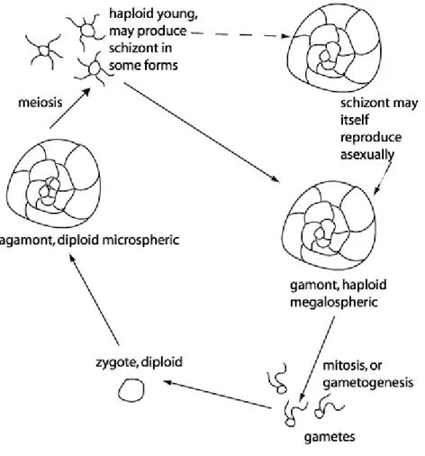
Foraminifera biology and ecology: proxies for environmental health
Foraminifera are single celled protozoans that consist of successive chambers and widely distributed in marine environment from the intertidal zone to the deep ocean floor, range from the polar region to the Equator, in marginal to deep basin. In the fifth century B.C., Herodotus reported that large benthic foraminifera of the genus
Nummulites are abundant in the limestone used to build the Egyptian pyramids at Gizah.
In the 16th and 17th centuries, smaller foraminifera were for the first time described, illustrated, and variously classified. The French naturalist Alcide d‘Orbigny (1826) revolutionized the foraminifers‘ taxonomy describing them as tiny cephalopods. Felix Dujardin (1835) first determined their true protozoan nature and promoted their recognition as a separate Class (d‘Orbigny, 1839).
The famous world cruise of H.M.S Challenger in 1880‘s collected many samples and Henry Bowman Brady (1884) illustrated the foraminifera dredged from the sea floor. Throughout the 20th century, there were several prominent scientists working on in foraminiferal studies. Joseph Augustine Cushman and his team published 556 papers
and particularly the first journal on Contributions from the Cushman Laboratory for foraminiferal research (Cushman, 1927) and one of the most influential texts in the field is: ―Foraminifera: Their Classification and Economic Use‖ (Cushman J.A.,1928). Oil industry, after World War I, drove an impulse on the development of benthic foraminiferal biostratigraphy. In the decade prior to World War II, the Paleogene zonation was developed for the Caucasus Mountains of the southwest Soviet Union (Subbotina, 1953) and the Caribbean (Bolli, H., 1957a, 1957b, 1957c, 1966).
Furthermore, the postwar search for petroleum in Trinidad in the southernmost Caribbean region led to a revolution in biostratigraphy. The standard provided by Hans Bolli, who published Cretaceous and Tertiary zonation (Bolli, H. M., 1957a, 1957b, 1957c, 1966), was applied and expanded in the later biostratigraphic research (Blow, W.H., 1969, 1979; Berggren, W. A., 1969; Stainforth, R. M., et al. 1975).
Beside the development of foraminiferal biostratigraphy, the micropaleontological techniques expanded, to be applied to the ocean and deep-sea cores (Schott, D. W., 1935; Cushman, J. A., & Henbest, L.G., 1940; Emiliani, C., & Edwards, G., 1953; Ericson, D. B., & Wollin, G., 1956). The Deep Sea Drilling Project (1968 - 1983) contributed successfully to the expansion of the micropalaeontological investigations on deep-sea. Further studies on living foraminifera have contributed to the understanding of their fossil counterparts (Reiss, Z., & Hottinger, L., 1984, Hemleben, C. et al. 1989) and through foraminiferal ecology, this groups has become a tool for environmental analysis, providing bio-indicators for environmental stress and impacts from natural and anthropic hazards (Jorissen, F. J., 1988; Hottinger, L., & Pecheux, J. F., 1991).
According to the World Register of Marine Species (2018), at present there are 8,983 recognized recent species and 34,766 recognized fossil species recorded.
The classifications of foraminifera are based on the characteristics of the shell or test, including morphology, apertural structure, shell components, and types of chamber arrangements.
The tests of foraminiferal skeleton is secreted or agglutinated shell and consists of one or more chambers. The chambers are separated by septa, but with a continuous connection through a foramen in each subsequent septum. Through the opening on the last chamber, the protoplasm extends outside the test and the pseudopodia extrude to capture prey and aid in movement. The chambers may arrange as a single row