DOI 10.1515/agta-2017-0008
“LANDSCApp”: a friendly way to share the Italian geo-heritage
F
RANCESCAR.
L
UGERI1,2*,
P
IEROF
ARABOLLINI2,
N
ICOLAL
UGERI1,
V
ITTORIOA
MADIO3and
F
ABIOB
AIOCCO11ISPRA, Via V. Brancati 60, 00144 Roma Italy
2UNICAM, Via Gentile III da Varano, 7, 62032 Camerino MC, Italy
3Università MEDITERRANEA Salita Melissari, 89124 Reggio Calabria, Italy
(*Corresponding author e-mail: [email protected])
ABSTRACT
The geological landscape is an excellent topic for a better enhancement of the sustainable tourism. Considering Landscape as the result of the endogenous and exogenous activities that form the Earth's surface, and/or as the result of the interaction of many natural and cultural components, it is almost mandatory the use of such a theme as an informative vector in Environment Sciences popularization. Modern technology offers new powerful tools to reach and share a complete knowledge on the territory (intended as the integration between natural and cultural components). The overlay of thematic maps (geological, geomorphological, physiographic maps) as well as the integration of collected data allows us to identify the areas of greater natural and cultural value. The outdoor sports, expecially cycling and ski, give us an opportunity to talk about the territory, referring to its natural and cultural history; GIS and 3D modelling, are flexible and friendly tools in educational plans as well as in territorial promotion, fitting for the purpose of a twinning with TV sport transmission, as confirmed by the GeoloGiro experience (Geology at the Giro d’Italia 2013/14/15/16). The prototypical App here proposed, will show the landscape where the sports are played, through the visualisation of thematic maps and correlated images (3D modelling, animation, cartoons) integrating information on local environment and culture: the "LandscApp". We argue that special attention should be devoted to the link between landscapes, wine tourism and sports, and that this new field would spur new actions to promote sustainable development in Italy, as well as a more sensible culture of responsible wine consumption.
Keywords: Landscape, Heritage, Divulgation, Italy, Sport, SmartApp
INTRODUCTION
The variety of cartographic products made by the National Geological Survey and other Departments in ISPRA (the Italian National Institute for Environmental Protection and Research), allows a complete analysis of the landscapes that deeply characterize our country, identified through a dynamic pattern of the characterizing components. Starting from the existing data base and cartographic
documents (Geological and
Geomorphological Maps; Physiographic and environmental maps), the project aims to create a cartography of Italian landscapes, in correlation with those cultural issues significantly related to the territory, in comparison and integration with social-economic data.
The cognitive tools currently available, following the important trial during the International Year of Planet Earth, now enjoy a wide use and offer us a means of immediate communicative diffusion of scientific knowledge relative to an area and
an environment. The advent of GIS marked a real media revolution as it has provided us
with an integrated management
environment and an agile sharing of data, an interactive use of tools and contents, according to different levels of complexity and needs, presenting the various users/operators with new flexible means to arrive at new potential understandings. METHODOLOGICAL APPROACH IN ANALYSING LANDSCAPE
The Landscape Ecology approach allows us to recognise the main land settings, and evaluate the state of the environmental systems characterising our country.
Ecological – naturalistic value and territorial fragility of the studied areas, are investigated in a spatial-temporal scale, following a holistic approach that consider all the components of an area, in reciprocal interaction (Naveh & Lieberman, 1994), (Turner et al., 2001) (Amadio et al., 2002). One of the projects based on this approach in Italy, is the Carta della Natura project (APAT, 2003), which describes the Italian territory according to a multiscale and holistic approach.
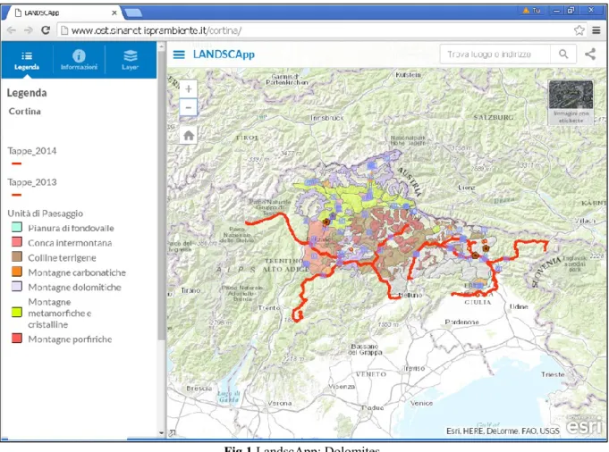
The study, performed at two principal scale of analysis (1:250.000 and 1:50.000), produced two different map outputs: the Landscape Physiographic Units (Fig. 1) and the Italian Habitats (Fig.2).
New ways in reaching a complete and effective understanding of territory, are a great resource, even at the level of tourism, which is a primary resource in the postmodern age. Studying “Landscape Units” and “Habitats” provides a guide for land management, sustainable development and risk assessment, in order to safeguard the landscape and promote and manage resources.
Nature and culture, incorporated in an index of environmental quality, despite their complexity, are easily understandable thanks to maps realised by GIS. The final indexes used to represent the state of the
habitat are: Ecological value, Ecological Sensitivity, Anthropogenic Pressure and Environmental Fragility. The Ecological-Environmental Value of a habitat is expressed by its characteristics that determine conservation priority. A bio-centric approach supported by a traditional anthropocentric one provides an integrated interpretation of ecological and economic components.
The sum of ecological value, socio-cultural value, and economic value determine the total value of the ecosystem to be used for land management and conservation.
The total value of the habitat is the result of the superimposition of environmental, economic, social and cultural values. The ecological value of an ecosystem in a bio-centric perspective is determined by structures and processes and is calculated by indicators which take into account structural aspects, institutional aspects, biodiversity and rarity. The Anthropic Pressure is intended as the disturbance that may concern both structural and functional characteristics of a habitat, including any process altering the birth/death rates of the individuals present in a patch (Petraitis, 1989). Anthropic Pressure is calculated by indicators like Fragmentation of the habitat, Constriction of the habitat, Demographic pressure (present/potential).
Environmental Sensitivity is intended as the potential hazard of a habitat to be degraded or lose its own identity from external pressures. (Ratcliffe, 1976). In calculating Environmental Sensitivity, indicators of the following are considered: compositional aspects (endangered species), structural aspects, institutional aspects, and isolation. The selected indicators are related to the hazard from CEE Directive (priority), from the presence of endangered vertebrates, from endangered flora, from rarity, from isolation, from ratio habitat area/total area of that type.
By combining a multi-criteria analysis of ecological sensitivity and anthropic pressure, it is possible to produce a map of
Fig.1 LandscApp: Dolomites
the fragility of habitats (Nilsson, 1995). NEW TOOLS FOR AN INTEGRATED
VISION OF THE TERRITORY:
“LANDSCAPP”
LANDSCApp gives the public a chance to try an alternative approach to the knowledge of the natural and cultural territorial heritage, thanks to a set of information related to the geological, morphological, environmental settings of the Italian Landscapes, integrated with other information on the traditional wine and food production.
Moreover, considering the vocation of some natural areas, for some outdoor sports, this App will include information on the most important sport challenges, performed by champions into the magnificent natural sceneries in our country.
LandscApp is an App for smartphone and tablets, now realized in an experimental version as a web App, available at the following link:
www.ost.sinanet.isprambiente.it/cortina The App has been presented in Cortina d’Ampezzo, on July. This tool aims to offer an unconventional approach to some scientific concepts, developed through images, maps, synthetic information, easily understandable, appealing to the public as well.
The Dolomites area, UNESCO World Heritage Site, represents an ideal location for developing and testing an appropriate methodology in the realization phase of the project, both for the natural beauty of the Landscapes and the available scientific information.
Sharing the project with the local society, during the project realization, is an essential part of the project itself.
The project starts from the collection of images, as a basis for an integration with the thematic Maps, reaching a Landscape analysis understandable and full of significance.
The Geological and Landscape Physiografic Unit Maps provide a different and wider point of view on many themes and it frames
the studied areas into a
Territorial/Environmental System.
Recent experiences (such as the “GeoloGiro: Geology at the Giro d’Italia”) confirm the increasing interest of the public in the geologic arrangement of the Italian peninsula. (Fig. 1, 2)
The project was welcomed by the organisers of the, Giro RCS Eds., the Italian Cycling Federation and Rai Sport (the Italian state TV company), which has included in the live programming of each stage -"Anteprima Giro"- a short insert dedicated to offering the public a new and interesting point of view of the landscapes and the sites, linking scientific information to the competitive value of the stage. The morphology of the territory becomes a key component in the context of the race; scientific information about the geo-morphologic settings of an area is related to cultural news and to the local arts and tradition (always deeply linked to environmental conditions).
A SPECIAL THEME: LANDCAPES AND WINES
By using advanced technological solutions, an appropriate use of GIS and the numerous correlated databases provide us with scientific tools that can depict the complex and rich reality of the areas of production that is typical of Italian wines. This informed position constitutes a starting point for modern planning policies for wine-producing areas and leads to a greater understanding of the culture of Italian wines, which can then in turn lead to the promotion and improvement of this “fruit of our land”. (Angelini et al., 2009), (Gregori, 2009), (Lugeri et al., 2009; 2011). As told before, modern mapping has a great potential for presenting comparisons and syntheses that are useful instruments in many situations: technical, scientific,
educational. Special attention is devoted to tourism since it represents both an opportunity for local development and a creative approach to educational programs. It also offers new opportunities to highlight the link between the Earth and its products (Montanari et al. 2008). In recent years, there has been growing attention in Italy towards wine production and promotion of this most important product on the national and global market and which has become a symbol of Italian culture throughout the world.
A further link, interesting for our project, is represented by the Giro d’Italia Wines’ stage (Fig. 3).
Economic and social efforts to bring about marketing of the wine and food industry are on the rise and they use the media to give wine a new image, underlining its refined and exclusive nature. In this context, the wine’s provenance on the geographical level and the reference to correlated disciplines are underlined, but the profound tie between wine and its “terra madre” has still not acquired a significant role on the stage of wine culture
Direct public participation results in a greater awareness of interaction with the environment and, as a consequence, induces
an informed consumption. Modern media and technological means used for geo-territorial study provide further and powerful instruments to spread and share knowledge
Wine, in particular, a protagonist in Italy’s culture (as in others’ too) given its constant presence in history and due to its very nature, has a tie to the land and therefore represents a path of geo-ecological-environmental knowledge. (Gregori, 2009).
Establishing an interest for wine by a process of recognition of territory through its manifestation in landscape can lead to the realisation of effective strategies for territory management (Brilha 2002), improvement aimed at reaching a consensus and participation of the local population, and strategies aimed at the attainment of goals based on a more stable and shared well-being.
The link between the environment in the areas of production and the characteristics of each wine are provided by some designations; for example the DOC areas (“Denominazione Origine Controllata”: mark guaranteeing the provenance and quality of a wine) are a significant mark of a territory. (Fig. 4)
Particular attention to viticulture and to the integration of this agricultural practice in the landscape is needed. Another fundamental element is the study of the substratum and the analysis of the soil. The soil cover is an element that characterises landscape and deserves a separate discussion. We observed that, apart from the territories greatly altered by humans such as the metropolitan areas, there is a clear correspondence on the regional scale between the soil cover pattern and the typology identified by the physiographic criteria. Another important aspect is the climate, which helps determine the configuration of the landscape
influencing the soil cover and the forms in relief due to the action of external processes. To this end we observed that types that are analogous yet located in different climatic contexts display different landscape structures. The climatic influence, in the context of landscape variability on the regional level, is explicated on a general hierarchical level. CONCLUSIONS
The presence of scientific information in the Italian media offer is still limited, mainly confined to an area that does not
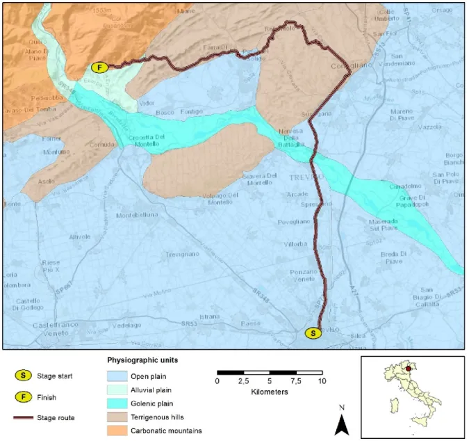
Fig. 4 Physiographic Units of the landscapes crossed by the wines’ stage Treviso Valdobbiadene Giro d’Italia
have sufficient exchange with the multiple communication channels. Even codes and styles of the proposals remain static in a format that often fades to spectacularization or myth, subtracting reliability to the scientific truth.
Modern media and technological tools used for geo-territorial studies (GIS) provide powerful instruments for spreading and sharing knowledge.
Referring to the important role of the Landscape in the Italian culture and economy, it is easy to understand the potential of a complete and synthetic tool, usable at different levels of needs, such as LandscApp can be.
A deeper reflection is devoted to Wine: it is a product deeply linked to its territory, and territory is nothing else than the result of the interaction between society and the natural environment. The extraordinary profusion of studies, and the continuous attention of the winemakers over many centuries, recently shared with the scientific community, point to the need for guidelines in order to reach more balanced land use policies and practices.
The sharing of scientific knowledge related to wine can be reached through an integrated study with the components of the various social structures and levels (schools, alpine communities, parks, protected areas) using experimental cultivation that, for example, would reintroduce in defined areas native grape varieties no longer used.
This approach to the use of natural resources and traditional cultures could help promote local development favourable for production and employment.
It is therefore finally possible without further hesitation, to put into effect and share with the general public a balanced land management and enhancement of places, also by way of an area’s typical products that are so deeply rooted the land. The knowledge of one’s own territory, is the first step towards a conscious knowledge, aimed to sustainable development and the prevention as well.
Ackonweldgement
The authors’ acknowledgement goes to the Carta della Natura Survey, particularly to R. Augello, R. Bagnaia, E. Canali, A. Cardillo, for the data sharing; to R. Capogrossi for the remarkable comments
REFERENCES
AA.VV. (2002) Spaces, environments and
landscapes of terroirs. Atti del Convegno Torino 2002, Torino, Italy: BEM.
Amadio, V. (2003) Analisi di sistemi e progetti di
paesaggio; Milano, Italy: Franco Angeli. (in Italian)
Amadio, V., Amadei, M., Bagnaia, R., Di Bucci, D., Laureti, L., Lisi, A,…, Lugeri, N. (2002)
The role of Geomorphology in Landscape Ecology: the Landscape Unit Map of Italy, Scale 1: 250,000 (“Carta della Natura” Project). In Allison, R.J (Ed.) Applied Geomorphology: Theory and Practice, (pp. 265–282), London, UK: Wiley.
Angelini S., Farabollini P. and Spurio E (2009) I
sistemi informativi geografici nella definizione dei terroir vitivinicoli: una applicazione nel terroir della Vernaccia doc di Serrapetrona (Marche centrali). Atti del Convegno Internazionale “I paesaggi del vino: cartografia e paesaggi”; (pp.55-78). Perugia, Italy: Boll. AIC.,
APAT (2003) Carta della natura alla scala
1:250,000: metodologie di realizzazione. Manuali e linee guida 17/2003, Roma , Italy: APAT. (in Italian)
APAT (2004) Carta della natura alla scala 1:50,000:
metodologie di realizzazione. Manuali e linee guida 30/2004, Roma , Italy: APAT. (in Italian)
Biancotti A., Pambianchi G., Pioletti A.M. and Marre A. (eds.) (2003) Espaces, environnements
et paysages des terroirs viticoles, Coll. Word in progress, Milano, Italy: B.E.M. editions
Brabazon, T. (2011) Swan Valley Sideways:
Economic Development through Taste and Tourism in Western Australia. Nebula,8(1), 62. Retrieved from Questia.
Brilha, J. (2002) Geoconservation and protected
areas. Environmental Conservation 29: (pp. 273-276), Cambridge, UK: University Press.
Catton, W.R. Jr. and Dunlap R.E. (1978).
Environmental Sociology. A New Paradigm. The American Sociologist, 13, 41-49. Retrieved from http://www.skidmore.edu/
Cita B. M., Colacicchi, R., Chiesa, S., Crisci, G. M., Massiotta. P. and Parotto, M. (2004) Italian
wines and geology. Coll. Paesaggi Geologici, Milan: BE-MA editrice.
wines. A book, an idea. Atti del convegno “Spaces, environments and landscapes of terroirs”, Torino 2002, IAG, Working Group on Terroirs viticoles, BEM Torino ,pp. 36-42.
Colacicchi, R. and Parotto, M, (2006) Geologia dei
vini italiani, Italia centrale. BE-MA editrice, Coll. Paesaggi geologici, Milan, pp 175. (in Italian)
Commission of the European Communities
(1991) CORINE Biotopes manual. Vol. 1, 2, 3. EUR
Dramis F. and Bisci, C. (1998) Cartografia
geomorfologica, Manuale di introduzione al rilevamento ed alla rappresentazione degli aspetti fisici del territorio. Bologna, Italy: Pitagora.
Farabollini, P., Lugeri, F.R., Amadio, V. and Aldighieri, B. (2014). The role of Earth Sciences
and Landscape Approach in the Ethic Geology: Communication and Divulgation for the Prevention and Reduction of Geological Hazards. In Lollino, G., Arattano, M., Giardino, M., Oliveira, R., Peppoloni, S., Engineering Geology for Society and Territory (Vol. 7, 115– 120). Heidelberg, Germany: Springer.
Forman, R. T. T. and Godron, M. (1986)
Landscape Ecology., NewYork, USA: John Wiley and Sons
Gregori, L. (2009) La cartografia “emozionale” dei
paesaggi del vino, La Cartografia, anno V, n.14, 2007, pp. 14-29. Trevi, Italy: Dipartimento Scienze della Terra, Università di Perugia. (in Italian)
Gregori, L. (2004). Percorsi geoturistici ed
enografici in Umbria. Atti 2° Convegno Geologia & Turismo “Opportunità nell’economia del paesaggio”, Bologna 3-4 novembre, pp. 58-60. (in Italian)
Lugeri, F.R. and Farabollini, P. (2015). Science
and society: new proposals for an unconventional
scientific communication. In Innovation in Ugolini F., Raschi A., Papageorgiou F., Environmental Education: ICT and intertegenerational learning. International conference proceedigs. (pp 87-93) Firenze, Italy: IBIMET-CNR.
Lugeri, F. R., Amadio, V., Cardillo, A., Bagnaia, R. and Lugeri, N. (2011) Landscapes and Wine
Production Areas: A Geomorphological Heritage. Geoheritage, vol. 3, 221–232.
Marre, A. (2004) Existe-t-il des terroirs viticoles en
Champagne?. Revue Géographique de l'Est 44 / 1-2. http://rge.revues.org/994. Accessed 26/7/2010
Montanari, A., Costa, N. and Staniscia, B. (2008)
La geografia del gusto. Ortona, Italy: Menabò (in Italian)
Naveh, Z. and Lieberman, As. (1994) Landscape
Ecology Theory and Application. Series on Environmental Management. Heidelberg, Germany: Springer.
Nilsson, C. N. and Grelsson, G. (1995) The fragility
of ecosystems: a review. Journal of Applied Ecology, vol. 32, 677–692.
Reynard, E. (2005) Géomorphosites et paysages.
Géomorphologie, relief, processus, environnement 3/2005, 181-188. (in French)
Troll, C. (1950). Die geografische Landschaft und
ihre Erforschung. Studium Generale. 3, 163-181. Heidelberg Germany: Springer. (in German)
Turner, M. G., Gardner, R. H. and O’Neill, R. V.
(2001) Landscape Ecology in Theory and Practice: Pattern and Process. New York, USA: Springer.
Vaudour, E. (2005) Terroir. Definizioni,
caratterizzazione e protezione. XI-295. Il sole 24 ore Bologna, Italy: Edagricole (in Italian)
Wolf, M. (1996). Teorie della comunicazione di
massa. Milano, Italy: Bompiani. (in Italian)