Full Terms & Conditions of access and use can be found at
https://www.tandfonline.com/action/journalInformation?journalCode=tjom20 ISSN: (Print) 1744-5647 (Online) Journal homepage: https://www.tandfonline.com/loi/tjom20
A combined approach for a modern
hydrogeological mapping: the case study of
Tennacola stream catchment (central Apennine,
Italy)
Marco Giacopetti, Marco Materazzi, Gilberto Pambianchi & Kristijan Posavec
To cite this article: Marco Giacopetti, Marco Materazzi, Gilberto Pambianchi & Kristijan Posavec (2019): A combined approach for a modern hydrogeological mapping: the case study of Tennacola stream catchment (central Apennine, Italy), Journal of Maps, DOI: 10.1080/17445647.2019.1574621
To link to this article: https://doi.org/10.1080/17445647.2019.1574621
© 2018 The Author(s). Published by Informa UK Limited, trading as Taylor & Francis Group
View supplementary material
Published online: 14 Feb 2019.
Submit your article to this journal
Science
A combined approach for a modern hydrogeological mapping: the case study
of Tennacola stream catchment (central Apennine, Italy)
Marco Giacopetti a, Marco Materazzi a, Gilberto Pambianchiaand Kristijan Posavec b
a
School of Science and Technology, University of Camerino, Camerino, Italy;bDepartment of Geology and Geological Engineering, University of Zagreb, Zagreb, Croatia
ABSTRACT
The current European water legislation, specifically the one addressed to groundwater for human consumption (EU Water Framework Directive, WFD-2000/60/EC), provides clear indications on the objectives and actions to be taken for the proper management and protection of water resources. In Italy, as well as in other countries of the EU, the implementation of this Directive, in the face of an adjustment of the legislation at national level, is still far behind, as regards the obligations on the part of local administrations. Among the reasons there is a lack of cognitive tools, adequate and, above all, univocally accepted by the scientific point of view. The hydrogeological mapping here presented, which covers an area of around 44 km2and is edited at 1:10,000 scale, goes in this direction, combining different approaches and methodologies (field surveys, spring hydrograph analysis, surface flow measurements, numerical models …) to arrive at a complete and functional study of an aquifer exploited for drinking purposes.
ARTICLE HISTORY Received 14 June 2018 Revised 22 January 2019 Accepted 23 January 2019 KEYWORDS Hydrogeological mapping; spring protection zones; central Italy
1. Introduction
Within the countries of the European Community, there is an increasing demand for sufficient quantities of good quality water for all purposes. Since 1995, mostly after the report of the European Environment Agency in which the need for action to protect Com-munity waters in qualitative and quantitative terms
has been emphasized (European Environmental
Agency [EEA], 1995), the Member States continued to work for an integrated Community policy on water.
The EU Water Framework Directive (European
Union (EU), 2000) has been a milestones in this regard, establishing a framework for Community action in the field of water policy.
Among the main provisions (art. 4 and 7), the Direc-tive indicates that the Member States, in order to reach ‘good status’ objectives for water bodies, shall put in place all the necessary actions to manage groundwater in a sustainable way, within 15 years after the entry into force of the directive itself (Voulvoulis, Arpon, & Giakoumis, 2017). Among the requirements:
. prevent or limit the input of pollutants into
groundwaters;
. prevent the deterioration of the status of all bodies of groundwaters;
. protection, enhancement and restoration of all
bodies of groundwaters.
At today, not all the Member States, including Italy, have followed the requests, or they have partially answered (Kanakoudis & Tsitsifli, 2010). The WFD recognizes that the achievement of good status might take more time in some water bodies. For this reason, it allows Member States to extend the deadline up to
2027 or beyond (European Union (EU), 2000;
Euro-pean Commission [EC] 2012).
In Italy, the Directive has been partially implemented through the Legislative Decree n.152 of 3 April 2006 (Italian Government, 2006). With the art. 64, the Decree has divided the national territory into eight Hydro-graphic Districts and provided for the drafting of a management plan for each District, assigning the respective competence to the river basin District auth-orities. Only some Districts have complied with the expected requirements within the established date (i.e. studies about the current and future availability of groundwater resources and/or delimitation of the
safe-guard areas of springs and well fields exploited for
drinkable uses) and many of them with different
approaches and methodologies (Bald, Borja, Muxika,
Franco, & Valencia, 2005; Richter, Völker, Borchardt, & Mohaupt, 2013). The‘Hydrographic District of cen-tral Italy’, where the test area chosen for the present work is located, is among these and many studies sup-porting these investigations are still being completed.
Hydrogeological mapping studies in this sector of central Italy, among other things, are not very frequent
© 2018 The Author(s). Published by Informa UK Limited, trading as Taylor & Francis Group
This is an Open Access article distributed under the terms of the Creative Commons Attribution License (http://creativecommons.org/licenses/by/4.0/), which permits unrestricted use, distribution, and reproduction in any medium, provided the original work is properly cited.
due to the lack of data and to the difficulty to carried out new surveys in relation to the legislative constraints.
Celico (1978, 1983) investigated the study area via field surveys, mechanical prospections and geophysical analysis. Investigations identify and quantify the groundwater resources at a regional scale. Later,Boni, Bono, and Capelli (1986)use a quantitative approach to characterize the karst basin, via groundwater bal-ances.Tarragoni, Martarelli, Pierdominici, Roma, and Boni (2011) edited an experimental hydrogeological map on fractured aquifer domains at 1:50,000 scale, basing on the results ofBoni et al. (1986).
The present work wants to provide a methodologi-cal contribution to these studies by proposing a model of hydrogeological mapping that integrates some of the most common approaches in the study of groundwaters, to arrive at a scientifically reliable tool, easily readable by administrators and technicians. Such a document is very effective if used, as in this case, in an area subject to naturalistic and landscape restric-tions, because located within a National Park (the Sibil-lini Mountains National Park) where tracers (natural and/or artificial) or invasive methodologies (monitor-ing wells, piezometers… .), considered dangerous for the environment, become impossible to use. Besides, in the study area as well as in other region of Italy and in several countries the Mediterranean basin a large part of drinkable sources are springs fed by non-Darcian aquifers (i.e. karst and carbonate) located
in complex mountain hydro-structures (Bakalowicz,
2015;Fiorillo et al., 2015); in this context, the presence of lithological and tectonic barriers as well as an highly heterogeneous permeability makes it very difficult to create a reliable 3D hydrogeological model. For such reason the study was based on a solid reconstruction of the water budget through detailedfield surveys,
frac-turing networks studies, riverflow measurements and
advanced analysis of spring hydrographs.
Concerning the qualitative aspects, specifically those aimed at the protection of groundwaters, a methodology for the definition of the aquifers vulnerability degree to pollution and a preliminary delimitation of the Springs Protection Areas, based on a mixed hydrogeological-temporal approach, is also applied. The method, start-ing from the work ofCivita (2008)based on the reces-sion curve analysis, has been already tested by other authors in several contexts of northern and central Italy (Biava, Consonni, Francani, Gattinoni, & Scesi, 2014;Menichini et al., 2015) and tries to bring reliable situations wherefield test data are not available.
2. Study area
2.1. Geological setting
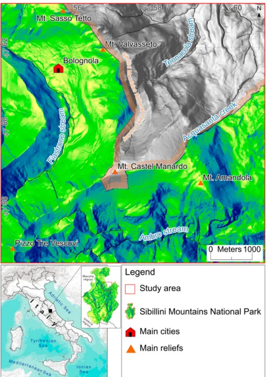
The study area (about 44 km2) is located in the north-east sector of the Sibillini Mountains and encompasses
an entirely mountainous territory between Mt. Sasso-tetto (1625 m a.s.l.) to the north and Pizzo Tre Vescovi (2091 m a.s.l.) to the south. Particularly, the area involves the mountain portion of the Tennacola
stream catchment between Mount Valvasseto
(1526 m a.s.l.) and Mount Castel Manardo (1977 m a.s.l.) and partially falls within the Sibillini Mountains National Park which, with an extension of about
700 km2, is the second largest in central Italy
(Figure 1).
The present landscape is characterized by the
presence of medium-high reliefs (Figure 1). The
fluvial system, generated deep and narrow valleys bor-dered by steep slopes: in this context, rare and thin are the continental deposits, almost always associated to
periglacial, gravitational or fluvial morphogenesis
(Aringoli et al., 2015).
Concerning the bedrock, all the outcropping for-mations belong to the Umbria-Marche Succession (Centamore & Deiana, 1986; Cosentino, Cipollari, Marsili, & Scrocca, 2010; Pierantoni, Deiana, & Gal-denzi, 2013), a sedimentary sequence consisting of limestones, marly limestones and marls interested since early Pliocene by an east-verging compressive tectonics followed by extensional tectonics and uplift-ing started at the end of early Pleistocene (Calamita & Deiana, 1988;Pierantoni et al., 2013). The Succession testifies the Jurassic transition between a platform sequence (Calcare Massiccio Fm.) to a basinal sequence (Corniola Fm., Bosso Fm. and Calcari Diasprigni Fm.), as well as condensed sequences (Buganore Fm.) lying on high tectonics reliefs. Basinal sequence continues through the Cretaceous and Tertiary with an alterna-tion of limestone and marls (Maiolica Fm., Marne a Fucoidi Fm., Scaglia Bianca Fm., Scaglia Rosata Fm., Scaglia Cinerea Fm. and Schlier Fm.). Tortonian sand-stone and clays uniformly cover the sequence (Schlier
Fm. and Flysch della Laga Fm.) (see the Main Map
for more details).
2.2. Hydrogeological setting
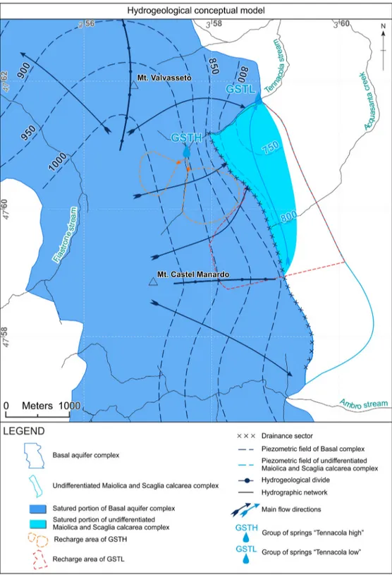
The presence of lithotypes with different degree of per-meability (for both the lithological characters and the different state of fracturing), generated three main aquifer complexes, alternated with low permeability formations (aquicludes or aquitards) (Figure 2). The most important is the Basal aquifer complex, made by the Calcare massicio and the Corniola formations and limited at the base by an impermeable evaporitic mem-ber of Triassic age, the Anidriti di Burano (Centamore & Deiana, 1986), made by alternances of dolomitic limestones, dolomites and evaporites. This complex hosts the regional basal aquifer of the central Apen-nines and feeds, by the linear streambeds (Boni et al., 1986), the major rivers which cut the Apennine chain in E-W direction.
Proceeding upward in the succession (Figure 2), two other aquifer complexes, Maiolica and Scaglia calcarea, are found in this order: they may constitute important reservoirs, but show usually a minor and irregular discharge.
Finally, the presence of tectonic elements with different hydrogeological behavior (i.e. as flow/no-flow boundaries) and the presence, locally, of more or less intense karst processes, can lead to the for-mation of local aquicludes/aquitards or create, on the other hand, hydraulic connections between different aquifer complexes (Boni et al., 1986;Nanni, 1991).
The geological formations of the Umbria-Marche succession are characterized by a typical chemistry
allowing to formulate hypotheses on the hydrogeologi-cal circulation within different hydrogeologihydrogeologi-cal com-plexes (Nanni, 1991). Consequently an enrichment in specific elements could be related to a flow mixing from different aquifer structures; enrichments in sul-phates and magnesium ions may in fact be associated to a deeper circulation that affects the dolomitic-anhy-dritic basement of the Umbria-Marche succession (Banzato et al., 2016;Nanni, 1991).
The study area, which includes the mountain por-tion of the Tennacola river catchment from the water-shed to the outlet located at an elevation of around 700 m a.s.l., is part of a larger hydrostructure elongated circa N-S (Boni, Baldoni, Banzato, Cascone, & Petitta,
2010) and limited to the east by the thrust of the Sibil-lini Mountains (which realizes the contact between the calcareous complexes and those terrigenous present outside the Apennine chain) and to the west by exten-sive Jurassic tectonic elements, reworked in compres-sive tectonic regime; these latter act as more or less confining hydraulic barriers (Pierantoni et al., 2013). According to Boni et al., 2010, the hydrostructure is
fully fed by the basal flow which is directed towards
the northern sector; the hydraulic gradient within the
hydrostructure ranges between 50‰ and 85‰ (Boni
& Petitta, 2007).
The upper portion of the Tennacola stream catch-ment hosts several important springs exploited for drinking water supply and located at a different elevation with respect the thalweg. For their location
and basing on the respective hydrogeological
characteristics, they can be grouped as follows (Figure 3):
. Group of springs ‘Tennacola high’ (GSTH) (mean
annual discharge– 16 L/s);
. Group of springs ‘Tennacola low’ (GSTL) (mean
annual discharge– 160 L/s).
All the springs show an extremely variable dis-charge, ranging from few to hundred L/s. The GSTH daylights in the uppermost portion of the basin at the contact between the fractured formation of Calcari Diasprini and the underlying low permeability for-mation of Calcari a Posidonia (silicoclastic-marly-cal-careous complex). More in detail, the group is
composed of two different point springs, ‘Anginelli’
and‘Gorga’, located respectively on the hydrographic left and right (Figure 3); the emerging waters are col-lected on two different tapped structures but measured together at a collector placed downstream.
The GSTL, on the other hand, is made by several
emergencies located at a different elevation on the
hydrographic right of the Tennacola catchment, between 700 and 735 m a.s.l. (Figure 3). It daylights at the contact between the Scaglia aquifer complex and the Scaglia Cinerea aquiclude (see the cross
sec-tions on theMain Map).
Less important in this portion of the basin is the role of continental deposits (slope and alluvial), cov-ering limited areas and characterized by low thick-ness. Only in correspondence with the GSTL tapped work and in the area close to the thrust, such deposits may create small aquifers or affect the runoff (Figure 4).
3. Material and Methods
The hydrogeological map (Main Map) has been edited
at a scale of 1:10,000. The basic topography was derived simplifying and adapting the national topographic map at 1:25,000 scale edited by the Italian Military Geo-graphic Institute (Istituto Geografico Militare [IGM],
1992). The WGS84 datum is adopted, and the metric
coordinates reported within the map refer to the UTM 33N Projection Zone.
The hydrogeological symbols adopted are partly
based on the recommendations of the Italian Official
Guidelines for Hydrogeological Surveys and Represen-tation (Mari, Motteran, Scalise, Terribili, & Zattini,
1995), edited by the Italian Geological Survey and
inspired by past experimental maps and proposals of implementation (La Vigna et al., 2016;Roma & Vitale, 2008; Tarragoni et al., 2011). In particular, different lithotypes were grouped in hydrogeological complexes by considering their relative permeability and their role according to groundwater circulation within the study area. The areal symbols for their representation adopt light to dark brown colors for medium-high permeability complexes and greenish to grayish colors for low and negligible permeability complexes (Main Map). A specific symbology, overlapping the areal symbol, was adopted where the complex showed a double behavior.
The hydrogeological survey in the study area and the data collection as a whole have been carried out in the period encompassing October 2012 and June 2014. For the location of all the hydrological and
hydrogeological elements a ‘Geomax’ total station,
based on both GPS and GLONASS Satellite Navigation Systems, has been used.
Climatological analyses have been conducted ela-borating rainfall, snowfall and temperature data from 16 weather stations provided by the Regional Civil
Pro-tection Agency of the Marche Region. In theMain Map
the spatial distribution of the main parameters (rain-fall, temperature, evapotranspiration, effective rainfall) within the study area have been described. The study area is characterized by an Apenninic-Adriatic regime with rainfall almost uniformly distributed throughout the year; Highest values are recorded late in Autumn and during spring while lowest one, in July and Janu-ary. The total annual precipitation often exceeds 1500 mm with the 1000 mm isohyet encompassing the whole mountain area. A snowy contribute from November to April is also present; quantity and persist-ence of snow increase with the altitude (Fazzini & Giuffrida, 2005). More in particular, in the study area, effective rainfall (Main Map) ranges from about 600 m/y to about 1200 m/y; assuming a negligible runoff in the study area (Boni et al., 1986; Giacopetti, Crestaz, Materazzi, Pambianchi, & Posavec, 2016b) and a highly fracturing of the outcropping lithologies, the value of the effective infiltration can be assumed as equal to the effective rainfall.
Spring discharge data, which covers a time span of around 10 years with a weekly frequency, have been kindly provided by the Tennacola Water Consortium, which is the managing company of the water plants. The captured springs are represented in the map with a light blue circle inside a black square; not captured or not investigated springs are described using a simple light blue circle. The size of symbols is proportional to the average discharge of each spring (see theMain Map). Geochemical data for both the groups of springs,
come from unpublished data collected byBaggio
Com-pagnucci (2008) and consist of a single sampling
car-ried out in July 2008. In the Main Map the above
mentioned data were displayed using Piper’s and Schoeller’s diagrams.
Concerning runoff measurement, a preliminary
monitoring of fluvial discharge has been carried out
along the uppermost portion of the Tennacola stream catchment, between the watershed and the outlet located at an elevation of around 600 m a.s.l., at the transition between the calcareous ridge and the terrige-nous lithotypes. This monitoring was developed by three campaigns of measurement between August 2013 and January 2014, in correspondence of 14 river
stations (Figure 3); however, during December 2013
and January 2014 it was not possible to collect data on thefirst three and on the first eight stations respect-ively (located in the uppermost portion of the Tenna-cola stream catchment) due to snow avalanche hazard and/or to bad weather conditions. Stream flow measurements have been collected by a USGS Type AA Current meter, after a detailed geometric reconstruction of the river cross sections.
Finally, the main groundwaterflow (basal), hosted
within the Basal aquifer complex, and that related to GSTH and GSTL have been reconstructed integrating
new field surveys (i.e. fluvial discharge monitoring
and geological-structural surveys), hydrogeological cross sections interpretation and bibliographic data (Boni et al., 2010; Boni & Petitta, 2007). The
piezo-metric field of the undifferentiated Scaglia calcarea
and Maiolica aquifer was derived by numerical ana-lyses and hydrogeological cross sections (Giacopetti et al., 2016b). All the elements related to the Basal
aqui-fer complex were described in the map (Main Map)
with a dark blue, on the other hand a sky blue was adopted for the undifferentiated Scaglia calcarea and Maiolica aquifer. Four hydrogeological cross sections (Main Map) have been realized in order to describe the groundwater circulation within the study area; the saturated portion of the aquifers has been here rep-resented using a specific symbol.
Figure 4.The image describes the hydrogeological configuration around a captation of the GSTL in two different period. On 22 August 2013 the Tennacola stream was dry; the piezometry was probably below the current thalweg, drained by the thicknesses of continental deposits covering the riverbed. On 17 December 2013 the Tennacola stream showed an increase of discharge prob-ably due to the snow melting contribute and/or influence exerted by the Basal aquifer complex.
Concerning the GSTL and GSTH, a preliminary definition of the Spring Protection Zones was carried out using a mixed temporal-hydrogeological approach, developed starting from the methodology proposed by
Civita (2008)forfissured/karst aquifers.
4. Results
4.1. Spring hydrograph analyses and water budget
Spring hydrograph analyses referred to the period 2004–2014 (Main Map) and performed using the Mail-let equation (Maillet, 1905) and the MRC methodology (Posavec, Bačani, & Nakić, 2006; Posavec, Giacopetti, Materazzi, & Birk, 2017; Posavec, Parlov, & Nakić,
2010), have been carried out in order to evaluate the main hydrological features of the GSTH and GSTL (Giacopetti, Materazzi, Pambianchi, & Posavec, 2017). The analysis of individual recessions periods showed substantial homogeneity of the recession con-stants (α), which range between 4.2·10−3and 8.0·10−3
(average value 6.0·10−3) for the GSTL and between
1.0·10−2and 2.0·10−2 (average value 1.3·10−2) for the
GSTH, confirming the results obtained by the
appli-cation of the MRC method (see the spring hydrograph analyses in theMain Map).
Starting from the spring hydrograph analysis, a
water budget for the same time span (2004–2014)
was developed (Giacopetti, Aringoli, Materazzi, Pam-bianchi, & Posavec, 2016a) for both the groups of
springs (Main Map), applying the methodology
described byKorkmaz (1990).
The analysis of the water budget evidenced a weak correlation between the peaks of spring discharge and peaks of rainfall (Giacopetti et al., 2017). It demon-strates the important role of the dynamic reserves (the volume of water stored at the end of the period of recession) mostly for what it concerns the GSTL; the average renewal rate (Trn) (the percentage of the
resource renewed during one hydrological year as an effect of real infiltration) here shows a value of 56% while is higher (82%) for the GSTH.
Quite interesting is also the delay time expressed in days, that indicates the period of time for which the
system would be able to supply a continuous flow at
the minimum rate, in the absence of replenishment
by infiltration (Civita, 2008). The analysis gave a
mean value of 160 days for the GSTL and 92 days for the GSTH, indicating a good capacity of both systems to overcome periods of drought.
Comparative analysis between total volumes deliv-ered by the springs and hydrogeological cross sections, made possible to define also the possible geometry and size of the recharge areas, which is about 3.8 km2for
the GSTL and 1.08 km2for the GSTH. The
reconstruc-tion for the GSTL has been also verified by a numerical
model developed using the software FEFLOW (
Giaco-petti et al., 2016b).
4.2. Aquifers geometry and groundwater pattern
Groundwater circulation in the study area can be split onto two distinct levels: a slower and deeper cir-culation, linked to the basal aquifer, and a more superficial one, closely connected to the upper aquifer complexes (Maiolica and Scaglia calcarea).
Hydro-chemical analyses (Main Map) confirm the presence
of calcium bicarbonate facies for both GSTH and GSTL, with enrichment in sodium, potassium, chlor-ine ions and medium-low values for sulphates and magnesium. Although these characteristics are typical of groundwater circuits inside the formations of the Maiolica and Scaglia calcarea, the GSTL shows values of sulphates and magnesium slightly higher than the
GSTH, highlighting a possible flow mixing from
different aquifer complexes. A chemical analysis of
one water sample taken from the source area of the
Aso river during July 2009 (Banzato, 2014; Banzato
et al., 2016) has been considered to the present
work to make a comparison with the GSTL (Main
Map). The source of the Aso river, emerging from
the Basal aquifer complex, is characterized by an enrichment of sulphate and magnesium ions respect-ively with values 6 and 20 times higher than those collected from the GSTL. The available samples of the springs studied are both useful in order to give a preliminary characterization of their chemical com-position; of course a single sample of water cannot be fully representative of the spring recharge system, but the comparison with the sample of the source of the Aso river (fully feed by the Basal aquifer) can be use-ful in order to add information about the hypothesis of a partial feeding by the Basal aquifer for the GSTL (Giacopetti et al., 2016b).
The results of the spring hydrograph analyses and the water budget, described in the previous paragraph, allowed to confirm the main hydrogeological features of the geological formations involved in the ground-water circulation (Giacopetti et al., 2017).
The GSTH is probably characterized by the presence of lithotypes with well-interconnected joints, resulting in a small recharge area and rapid emptying of the reservoir.
The GSTL is composed by the Maiolica and Scaglia calcarea formations characterized by a pervasive frac-turing and a low permeability matrix, allowing the gra-dual release of water over time and, as a consequence, slower emptying of the reservoir.
For both cases, the presence of conduits, associated with typical karst systems, cannot be ruled out,
even though its evaluation requires more data (Ford
Concerning the uppermost groundwater flow, the interpretative cross-sections shown in the
hydrogeolo-gical map (Main Map), evidence how the recharge to
the GSTH comes from the silico-marly calcareous com-plex, here with the role of aquifer/aquitard, highly frac-tured and with a low presence of marly levels, and partially from the Maiolica complex.
On the other hand, the feeding of the GSTL can be mainly associated to a recharge area constituted by the undifferentiated Scaglia calcarea and Maiolica aquifer. The Scaglia and the underlying Maiolica aquifer, which are here stratigraphically reversed,
form a unique hydrogeological complex and are hydraulically connected for the reduced thickness of the Marne a Fucoidi low permeability formation interposed in between; this formation is partially elided or absent because of the effects of the com-pressive tectonics and the presence of the thrust planes (Main Map).
Nevertheless, as above stated,Giacopetti et al., 2016b
have hypothesized, in the north-eastern sector, the pres-ence of limited drainance phenomena (Figure 5); more in detail, a mean annual contribution of around 11.7 Mm3/y (corresponding to 20% of the mean annual
discharge) coming from the Basal aquifer has been hypothesized (Giacopetti et al., 2016b).
The spring hydrograph analysis (Main Map)
evi-denced also an increase in the slope of the recession
curve probably associated with snow melting
contribution and/or influence exerted by the Basal aquifer, as mentioned previously (Giacopetti et al., 2017).
The fluvial discharge surveys (Figure 3) carried
out over the years 2013–2014 highlighted, in the monitored stations, a high discharge variability along the river bed; the river is almost dried in
August, while shows significant increases in
Decem-ber and January.
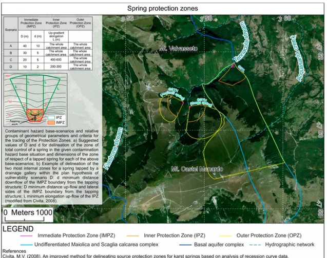
4.3. Spring protection zones definition
The method of Civita (2008), here adopted for the
definition of the Springs Protection Zones for both
GSTH and GSTL, takes into consideration the annual maximum discharge half-time (MDHT) of the spring (Civita, 2008); this is an easily recordable parameter which can be related to the mean time of propagation of a generic hydro-conveyed pollutant towards a spring without any attenuation. Depend-ing on the MDHT, four contaminant hazard base-scenarios, associated with as many groups of
geometrical parameters and criteria for the tracing of the relative Protection Zones, can be identified (Figure 6).
Basing on this method and the related nomographs (Civita, 2008), and after a careful choice of the best representative recession periods during the years, the class C (MDHT ranging from 20 to 50 days) for both the GSTL and the GSTH has been obtained and three Protection Zones have been delineated:
(1) an Immediate Protection Zone (IMPZ), con-sidered the one with the highest defence, with a minimum distance of 5 m down-flow of the boundary from the tapping structure and a mini-mum distance of 20 m up-flow and lateral sides of the boundary from the tapping structure; (2) an Inner Protection Zone (IPZ), strictly based to
the time of travel of a generic contaminant, with a minimum elongation of 400 m up-flow, accord-ing to an arc of circumference of about 60°; (3) an Outer Protection Zone (OPZ), outlined with a
hydrogeological criterion and which includes the entire recharge area of the aquifer (around 3.8 km2for the GSTL and 1.08 km2for the GSTH). The definition of Protection Zones automatically will provide for the imposition of restrictions on the
territory; these restrictions, in Italy, have been regu-lated within the art. 94 of the Legislative Decree n.152 of 3 April 2006.
5. Discussion and concluding remarks
The hydrogeological map of the upper Tennacola
stream catchment (Main Map) represents a step
for-ward tofor-wards a more modern concept of hydrogeologi-cal mapping, integrating data and information typihydrogeologi-cal of the traditional mapping (i.e.field surveys and/or in situ and laboratory measurements) with the analytical potential provided by numerical models and by the use of Geographical Information Systems.
First of all, it has been designed to let itself easy to use by experts, public administrations and stakeholder-sand to represent overlapping information layers: hydro-structures are mapped together with equipoten-tial lines and relative flowpath arrows, water divides and other hydrogeological features.
The reading and identification of the hydrogeologi-cal complexes has been improved using a specific abbreviation, resulting particularly useful in situation where the hydrogeological complex shows a double behavior, e.g. the Marne a Fucoidi formation can play the role of aquitard (MFCb) or aquiclude (MFCa) between the Scaglia calcarea and Maiolica aquifer, depending on the structural and tectonic context.
The evaluation of the double behavior of the silico-clastic-marly-calcareous complex in the study area was
a new important information in the Main Map; a red
symbol was adopted to describe the degree of fractur-ing of the complex in the sector close to the emergence of the GSTH. Moreover the study has evidenced the presence of a drainance sector (described by a black lin-ear element) in between the undifferentiated Scaglia calcarea and Maiolica aquifer and Basal aquifer
com-plex (Main Map) highlighting a possible hydraulic
connection.
All the hydrogeological features have been syn-thesized in a hydrogeological conceptual model (Main Map) in order to clarify the assumptions at the base of the present work.
The evaluation of the spring protection zones has represented a crucial point of the present study; the application of Civita method has been necessary due to the complex and heterogeneous geological features of the study area. On the other hand, the application of a traditional methodology on the study area, on the other hand, would induce a subjective and sim-plified interpretation, which does not take into account all the variables involved.
In conclusion, for a modern hydrogeological map-ping, a combined approach is all the more fundamen-tal, as in the present work, if used to support the definition of the vulnerability degree to pollution of an aquifer that requires qualitative and quantitative
information about the numerous aspects involved (aquifer type, characteristics, direction and velocity of groundwaters, presence of potential sources of pol-lution…); all this in compliance with the indications provided by the current European water legislation. The hope is that such a modern approach will can pro-vide a baseline for future monitoring in view of an increasingly correct and rational use of water resources, especially when used for drinking water purposes.
Software
All data processing and spatial analysis regarding the map were performed by ESRI ArcGIS software. Cross
sections and the final editing of the map were
per-formed using CorelDRAW Graphics Suite.
Acknowledgement
The authors want to thank Sergio Paolucci and Gianni Mat-tiozzi of the Tennacola Water Consortium for kindly provid-ing all the data (discharge, chemical analysis, etc.) of the springs and for the useful discussions during the drafting of this manuscript. Moreover, they want to thank the reviewers for the pertinent suggestions that improved the final version of the manuscript.
Disclosure statement
No potential conflict of interest was reported by the authors.
ORCID
Marco Giacopetti http://orcid.org/0000-0002-3066-564X
Marco Materazzi http://orcid.org/0000-0002-9480-5680
Kristijan Posavec http://orcid.org/0000-0002-5392-9329
References
Aringoli, D., Buccolini, M., Coco, L., Dramis, F., Farabollini, P., Gentili, B.,… Pambianchi, G. (2015). The effects of
in-stream gravel mining on river incision: An example from central Adriatic Italy. Zeitschrift für Geomorphologie, 59 (2), 95–107.doi:10.1127/zfg_suppl/2015/S-59206
Baggio Compagnucci, A. (2008). Analisi geologico-strutturale e idrogeologia dell’alto bacino del torrente Tennacola, Sarnano (MC) (Unpublished master’s thesis). University of Camerino, Camerino, Italy, p. 334.
Bakalowicz, M. (2015). Karst and karst groundwater resources in the Mediterranean. Environmental Earth Sciences, 74, 5–14.doi:10.1007/s12665-015-4239-4
Bald, J., Borja, A., Muxika, I., Franco, J., & Valencia, V. (2005). Assessing reference conditions and physico-chemical status according to the European water frame-work directive: A case-study from the Basque Country (Northern Spain). Marine Pollution Bulletin, 50(12), 1508–1522.
Banzato, F. (2014). Caratterizzazione delflusso in acquiferi carbonatici fratturati dell’Italia centrale per la gestione e la protezione delle risorse idriche sotterranee (Unpublished PhD thesis). University of Rome “La Sapienza”, p. 175.
Banzato, F., Mastrorillo, L., Nanni, T., Palpacelli, S., Petitta, M., & Vivalda, P. (2016, June 22–23). L’acquifero carbona-tico fratturato delle Sorgenti del Fiume Aso (Parco Nazionale dei Monti Sibillini): valutazioni sulla risorsa rinnovabile e sull’area di alimentazione. Atti del Convegno Nazionale “La ricerca carsologica in Italia”, laboratorio carsologico sotterraneo di Bossea, Frabosa Soprana, pp. 137–145.
Biava, F., Consonni, M., Francani, V., Gattinoni, P., & Scesi, L. (2014). Delineation of protection zones for the main discharge area of the Gran Sasso Aquifer (central Italy) through an integrated geomorphological and chronologi-cal approach. Journal of Water Resource and Protection, 6, 1816–1832.
Boni, C., Baldoni, T., Banzato, F., Cascone, D., & Petitta, M. (2010). Hydrogeological study for identification, charac-terization and management of groundwater resources in the Sibillini Mountains National Park (central Italy). Italian Journal of Engineering Geology and Environment, 2, 21–39.doi:10.4408/IJEGE.2010-02.O-02
Boni, C. F., Bono, P., & Capelli, G. (1986). Schema Idrogeologico dell’Italia Centrale. Memorie Società Geologica Italiana, 35, 991–1012.
Boni, C., & Petitta, M. (2007). Studio idrogeologico per l ’iden-tificazione e la caratterizzazione degli acquiferi che alimen-tano le sorgenti dei corsi d’acqua perenni dei Monti Sibillini, esteso all’intera area del Parco Nazionale. Rapporto definitivo. Contratto di studio e ricerca (Technical note). Sapienza University of Rome, Rome, Italy, p. 97.
Calamita, F., & Deiana, G. (1988). The arcuate shape of the Umbria-Marche-Sabina Apennines (central Italy). Tectonophysics, 146, 139–147. doi:10.1016/0040-1951 (88)90087-X
Celico, P. (1978). Schema idrogeologico dell’Appennino car-bonatico centro-meridionale. Memorie e Note Dell’Istituto di Geologia Applicata, 14, 97.
Celico, P. (1983). Idrogeologia dei massicci carbonatici, delle piane quaternarie e delle aree vulcaniche dell’Italia centro meridionale (Marche, Lazio meridionale, Abruzzo, Molise e Campania). Quaderni Della Cassa per il Mezzogiorno, 4 (2), 203.
Centamore, E., & Deiana, G. (1986). La Geologia delle Marche. Studi Geologici Camerti, vol. spec., p. 145. Civita, M. V. (2008). An improved method for delineating
source protection zones for karst springs based on analysis of recession curve data. Hydrogeology Journal, 16, 855– 869.doi:10.1007/s10040-008-0283-4
Cosentino, D., Cipollari, P., Marsili, P. & Scrocca, D. (2010). Geology of the central Apennines: A regional review, in the geology of Italy: Tectonics and life along plate mar-gins. In M. Meltrando, A. Peccerillo, M. Mattei, S. Conticelli and C. Doglioni (Eds.). Journal of Virtual Explorer, 36, 36.
European Commission (EC). (2012). Report from the com-mission to the European Parliament and the council on the implementation of the water framework directive (2000/60/EC) river basin management plans, p. 16. European Environmental Agency (EEA). (1995). EEA
annual report 1995. p. 56.
European Union (EU). (2000). EU directive 2000/60/EC of the European Parliament and of the council of the 23 October 2000 on institution of a scheme for communitar-ian action for water. OJEU, 22/12/2000 L. 327/01–327/ 73. Retrieved fromhttp://www.ojec.com/
Fazzini, M., & Giuffrida, A. (2005). Une nouvelle proposition quantitative des regimes pluviometriques dans le territoire
de l’Italie: premiers resultats. In Climat Urbain, Ville et Architecture, Actes XVIII Colloque Internationale de Climatologie, pp. 361–365.
Fiorillo, F., Petitta, M., Preziosi, E., Rusi, S., Esposito, L., & Tallini, M. (2015). Long-term trend and fluctuations of karst spring discharge in a Mediterranean area (central-southern Italy). Environmental Earth Sciences, 74, 153– 172.doi:10.1007/s12665-014-3946-6
Ford, D. C., & Williams, P. W. (2007). Karst hydrogeology and geomorphology. London: Wiley.
Giacopetti, M., Aringoli, D., Materazzi, M., Pambianchi, G., & Posavec, K. (2016a). Groundwater recharge estimation using spring hydrographs: The case of the Tennacola car-bonate aquifer (central Apennine, Italy). Rendiconti Online Della Società Geologica Italiana, 41(1), 61–64.
doi:10.3301/ROL.2016.93
Giacopetti, M., Crestaz, E., Materazzi, M., Pambianchi, G., & Posavec, K. (2016b). A multi-model approach using stat-istical index and information criteria to evaluate the ade-quacy of the model geometry in a fissured carbonate aquifer (Italy). Water, 8, 271.doi:10.3390/w8070271
Giacopetti, M., Materazzi, M., Pambianchi, G., & Posavec, K. (2017). Analysis of mountain springs discharge time series in the Tennacola stream catchment (central Apennine, Italy). Environmental Earth Sciences, 76, 1–11. doi:10. 1007/s12665-016-6339-1
Istituto Geografico Militare (IGM). (1992). Carta topografica d’Italia a scala 1:25,000. S.E.L.C.A. Firenze.
Italian Government. (2006, April 14). Legislative decree no. 152/06 approving the code on the environment (Official Gazette of the Italian Republic no. 88). Rome: Italian Government Polygraphic Institute, p. 232.
Kanakoudis, V., & Tsitsifli, S. (2010). On-going evaluation of the WFD 2000/60/EC implementation process in the European Union, seven years after its launch: Are we behind schedule? Water Policy, 12, 70–91.
Korkmaz, N. (1990). The estimation of groundwater recharge from spring hydrographs. Hydrological Sciences Journal, 35, 209–217.doi:10.1080/02626669009492419
La Vigna, F., Mazza, R., Amanti, M., Di Salvo, C., Petitta, M., & Pizzino, L. (2016). The synthesis of decades of ground-water knowledge: The new hydrogeological Map of Rome. Acque Sotterranee – Italian Journal of Groundwater, 4 (142), 9–17.doi:10.7343/AS-128-15-0155
Maillet, E. (1905). Essais d’Hydraulique Souterraine et Fluviale. Paris: Librairie Scientifique A. Hermann, p. 218. Mari, G. M., Motteran, G., Scalise, A. R., Terribili, D., & Zattini, N. (1995). Carta Idrogeologica d’Italia – 1:50.000. Guida al rilevamento e alla rappresentazione. Quaderni del Servizio Geologico d’Italia, Serie III, 5, IPZS, Roma.
Menichini, M., Da Prato, S., Doveri, M., Ellero, A., Lelli, M., Masetti, G.,… Raco, B. (2015). An integrated method-ology to define protection zones for groundwater-based drinking water sources: An example from the Tuscany Region, Italy. Acque Sotterranee – Italian Journal of Groundwater, 21–27.doi:10.7343/AS-102-15-0129
Nanni, T. (1991). Caratteri idrogeologici delle Marche. In “L’Ambiente fisico delle Marche”, ed. da Regione Marche e S.E.L.C.A. Firenze.
Pierantoni, P., Deiana, G., & Galdenzi, S. (2013). Stratigraphic and structural features of the Sibillini Mountains (Umbria-Marche Apennines, Italy). Italian Journal of Geosciences, 132(3), 497–520.doi:10.3301/IJG. 2013.08
Posavec, K., Bačani, A., & Nakić, Z. (2006). A visual basic spreadsheet macro for recession curve analysis. Ground
Water, 44(5), 764–767. doi:10.1111/j.1745-6584.2006. 00226.x
Posavec, K., Giacopetti, M., Materazzi, M., & Birk, S. (2017). Method and excel VBA algorithm for modeling master recession curve using trigonometry approach. Ground Water, 55(6), 891–898,doi:10.1111/gwat.12549
Posavec, K., Parlov, J., & Nakić, Z. (2010). Fully automated objective-based method for master recession curve separ-ation. Ground Water, 48(4), 598–603. doi:10.1111/j.1745-6584.2009.00669.x
Richter, S., Völker, J., Borchardt, D., & Mohaupt, V. (2013). The water framework directive as an approach for inte-grated water resources management: Results from the experiences in Germany on implementation, and future perspectives. Environmental Earth Sciences, 69, 719–728.
doi:10.1007/s12665-013-2399-7
Roma, M., & Vitale, V. (2008). Strumenti e metodologie informatiche per l’idrogeologia: dai dati alla rappresenta-zione cartografica. In A. R. Scalise & L. Martarelli (Eds.), Studi sperimentali finalizzati alla cartografia idrogeolo-gica. Memorie Descrittive della Carta Geologica d’Italia, 81, 47–58.
Tarragoni, C., Martarelli, L., Pierdominici, S., Roma, M., & Boni, C. F. (2011). A proposal for compiling quantitative hydrogeological maps. Rendiconti Online della Società Geologica Italiana, 14, 75–85. doi:10.3301/ ROL.2011.07
Voulvoulis, N., Arpon, K. D., & Giakoumis, T. (2017). The EU water framework directive: From great expectations to problems with implementation. Science of Total Environmental, 575, 358–366. doi:10.1016/j.scitotenv. 2016.09.228