€
€
€
BY NCConstruction Site Planning for the
Reconstruction of a Historic Earthquake
City: the Case Study of L’aquila
Serena Di Marco
KEYWORDS: earthquaKe, L’Aquila, reconstruction, construction site planning, earthquaKe old toWn
The earthquake that hit the city of L’Aquila on 6th April 2009 represents the fi rst seismic event, after that of Messina in 1908, that interested such a wide and urbanized area as that of a county seat. Emerged problems after this occurrence, the mistakes that have been made and the set of adopted solutions, made L’Aquila to become a real “knowledge laboratory”.
In this context, the attention focuses on the complex issue of L’Aquila old town reconstruction, often defi ned by the most important newspapers as “the biggest construction site of Europe”. Once have analyzed the procedures that the city council put in place, it is observed an absence of an instrument of planning through which to coordinate the construction sites simultaneously operating on the area. The fi rst to deal with this problem has been the municipality of Villa Sant’Angelo, that through the drafting of a “general construction site plan”, attempted to manage the critical issues about reconstruction. Starting from this cue, an elaboration of a general construction site plan is proposed for the “central axis” of L’Aquila old town. The goal is to plan construction site activities on the base of strategic choices followed from L’Aquila old town conditions after the earthquake, by referring to an urban scale instead of considering individually each single construction site. Awork plan is obtained throughthe defi nition of requirements concerning the priority criteria for action, the old town viability, the logistics of construction sites and the rubbledisposal. This plan fosters a more functional and safer reconstruction, and a fairer use of public spaces from companies which execute private works.
Therefore, by using as starting point the implementation of the method in the case study of L’Aquila, it is here proposed an application solution concerning the management of reconstruction of Italian old towns hit by earthquakes.
I
taly is one of the countries in the Mediterranean area which has got higher seismic risk, because of both thefrequency of the earthquakes that hit the country throughout history, and for their magnitude. The earthquake that hit the city of L’Aquila on 6th April 2009 generated a so-called seismic crater that comprises 56 municipalitiesandconcernsan area ofalmost 2.400 Km². In light of this, the reconstruction process of L’Aquila has been soon defined as “the biggestconstruction site of Europe”. Because of the particularly complexsituation, the seismic crates became a real “knowledge laboratory”. This experience, in fact, reignited in everyone the sense of importance of seismic prevention in Italy, and let also to implement new models and techniques of intervention both in the emergency phase and in that of reconstruction.
In an old town that has been hit by an earthquake, there are two typologies of after-earthquake construction site.
A first typology is the one concerning the moment immediately after the emergency and that includes construction sites for compellinginterventionof safety works. The second typology refers to building sites for reconstruction. Those operate by following the rules laid down in theUniform Codeof Health and Safetyat Work, butdisplay more complex scenarios in comparison with a commonbuilding site, due to the presenceofvarious risk factors. It is clear that for a construction site of an old town
reconstruction it is necessary to foresee very specialplanning and organization features, that aim to obtainaflexible and complex structure, articulated on the base of the nature of the existing one. The main problemsthat can be observed in this field concernin particular: the management of public spacesby many construction sites, the existence of impactfulemergency structures and areduced viability with a subsequent reduction of room for means maneuver. Despite these are problemsconcerning in particular executing companies of private works,it is necessarythat the city council manages and leads the reconstruction throughthe action planning on a urban scale. What has been missing in L’Aquila has been the cooperationbetweenpublic and private spheres;this brought to a plannedand, consequently, non-homogeneous reconstruction. In light of this, it has been developed ageneral construction site planfor the old town of L’Aquila,which provides the guidelines for implementinga more functional and coordinatedreconstruction. The main objective of the plan it will be to develop a logical approach to design and organize the reconstruction site on an extensive area. The development of the general construction site plan for the case of L'Aquila represents the starting point for having the tools to better understand the problem of the reconstruction site management. In this way, it will be possible to apply this method, not only for the territories hit by the earthquake but also for those affected by other disasters due to natural hazards (e.g. floods, tsunamis, landslides, etc.). THE RECONSTRUCTION OF L’AQUILA OLD TOWN
The Reconstruction Plan
The approach adopted by the Municipality of L’Aquila for reconstruction activities is based oncontents of the extraordinary legislation on reconstruction, issued by the Government and the Commissioner-Delegate; those are the Law n. 77 of
24th June 2009 and the Decree n. 3 of 9th March 2010, respectively. In particular, thelaw 77/2009 introduces againtheReconstruction Planas an instrument ofurban planning by settingits aims, including: the socio-economic recovery of thecity, the upgrading of the housing stockand the returnof people into the houses damaged by the earthquake. TheReconstruction Planis defined as technical instrument, which unifies more “levels of planning” asthestrategic plan, the generalurban equipmentand the implementing planning. Those arecomprised in a single and articulate planning programmingprocess.
The above-mentioned decreesets goals and procedures for the drafting of the Reconstruction Plan. In particular, with a view to the arrangement of thestrategic guidelines for old towns reconstruction, the Municipality of L’Aquila defined theboundaries of eachold town in the county seat and in the hamlets, byidentifyingreconstruction settings. Into those settings, it is forecasted the presentation and the following checkof intervention proposalsafterpublic notices issued by the Mayor. This approach favors the current urbanand territorial prefiguration,while pursuing the direct and freerecovery and consolidation measures of damaged buildings; this is made throughthe possibilitytoproceed with the reconstruction by usingproposing plans,made bysingle areas or sections of areas, in conformity withthe current Land-use planning. By following this line of action,theold town reconstructionhas been left to chance,to the individual initiative and without an overview of the city. For all those reasons, the reconstruction plan turns out to be an ineffective instrumentfor managing the reconstruction of L’Aquila. The office for the super-coordination of construction sites
With the Protocol of Understanding called Emergenzasisma Abruzzo 2009, of 30th November 2009, ithas been agreed on the necessity to optimizeand safely managethe multitude of
temporary or mobile construction sitesin the old town of L’Aquila, during the phase of the buildings securing. It has been set up the Office for the Super-Coordination of Safety in Construction Sites. In the same protocolit has been considered, moreover, the extensionof the officetasksalso during the reconstruction phase. The Office for Coordinationrepresentsa supportfor the municipal Administrationand is mainlycommitted to the control of eachSafetyCoordinator’s tasksrelatively to provisions and requirements aimed to the respect of the current regulation on safety in work places. During the phaseof L’Aquila old town reconstruction, the main activities of the office concernthe definition of the safety and health requirements for the logistic of construction sitesand the requirements for the behavior of Safety Coordinators (in the phases of projecting and implementing) and of executing companies. In particular,techniciansof USC complement the Coordinators during the phase of implementingthe activitiesrelated withthe logistic of construction sites’ common areasand the managingof interferencesamong many processing,by organizing periodic meetingsof construction sites coordinationand by encouraging training meetingsin order to make known all the issues concerning the risks in the construction sites for reconstruction. Although this represents a key aspectin the field of a such complex reconstruction,the office for the coordination of construction sitesdrafts guidelines limited only to the issueof safety in the construction sites and to the controlofregularityof workersduring the operative phase of the construction sites.
The general construction site plan of Villa Sant’Angelo
By analyzingthe difficultdevelopmentof reconstruction of L’Aquila old town, it results essential the contribution given by the municipality of Villa Sant’Angelo (AQ),with the development of theGeneral
Construction Site Plan of its old town and od the hamlet Tussillo. The project starts with the goal to meet the requirements of companies that are going towork simultaneously in the hamlet old town, in order to let them avoid, for example, problemsin the implementing phase of the construction site, related to a wrong positioning of the crane form a company which could hinder the installation of equipment in adjacent construction sites.Relating to this, it is considered that each Safety Coordinator, when drafting the Safety and Coordination Planning, should include also the claims contained in the General Construction Site Planof the related construction site. In particular, the plan include a series of graphical documentswhich relate to: the partition in transit areas, with the aim to better organize the spaces management; the identification of vehicle accesses to the old townand the mainviable ways of which the smallest dimensions of roadway are given; the identification of the already working construction sites; the indication of spaces to be allocated to each construction site (crane, storage areas, scaffolds); the arrangement of an emergency plan; a more detailed evaluation referring to the dimensions of the streets and the resulting biggest dimension of the scaffolding that could be installed, in order to preserve the viability.
In all the documents, the area of the Municipality is analyzed as a single construction site, without considering special provisionsfor each built-up area; it is considered the whole old townby analyzing all the featuresin order to evaluatethe possible risk scenarios. The general construction site plan of Villa Sant’Angelo, for its importance, is considered to be a “pilot project”,because it has got all the features to be presented to the other municipal administrations in the area hit by the earthquake, as a practice to be preferredin the field of reconstruction. Nevertheless, the project has never been taken into consideration by the Municipality of L’Aquila and it is not clear the reason of it. In respect of this, it is necessary to
make some considerations: the widthof the surface area of the Municipality of L’Aquila is almosthundred times bigger in comparison with that of Villa Sant’Angelo, that is a small hamlet with only 427 inhabitants; moreover, the old town of L’Aquila is characterizedby a considerable
culturalheritagethatmakes itone of the main medieval centerof central Italy. On the base of these evaluations, the municipality’s choicenot to consider a planning toollike that of Villa Sant’Angelo could seem nearly forced, however it is still unjustified. The result of those
Figure 3: Way typologies identified on the base of their dimension choicesis in fact clearin the troubled
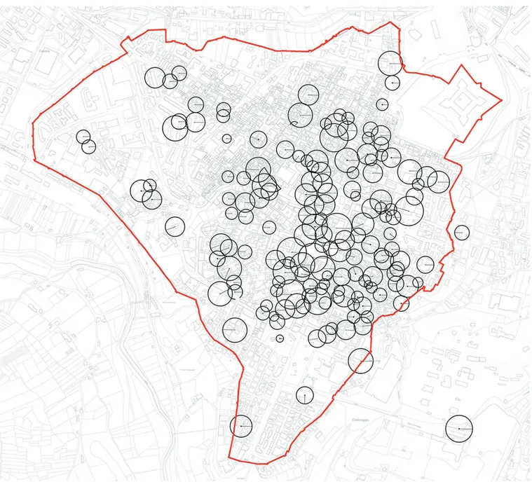
situationsthat can be found in the old town of L’Aquila. A striking example of this is the well-known problemrelated tothe multitudeof working cranesin the city old townand the connected problemsdue to interferences. (Fig. 01) GENERAL CONSTRUCTION SITE PLAN IMPLEMENTATION: THE CASE STUDY OF L’AQUILA
Without the drafting of a general construction site plan, the reconstruction process risks to be abandoned to the private initiative. The result, as it actually happened in the old town of L’Aquila, is
that the choices of the building company that receives first the grant for starting the works, could hinder the organization of the adjacent construction sites, making them start later with the work implementation.As in the plan issued by the Municipality of Villa Sant’Angelo, also for the old town of L’Aquila it is proposed the elaboration of a method aimed to define the technical guidelines to create a safer and more efficient construction site. More specifically,an example of implementation is suggestfor a section of the central axis of the city old town. The central axis is an area of the old town of L’Aquila thatstretches alongthe main guideline (Corso Vittorio Emanuele). This is the city fulcrum, but at the same
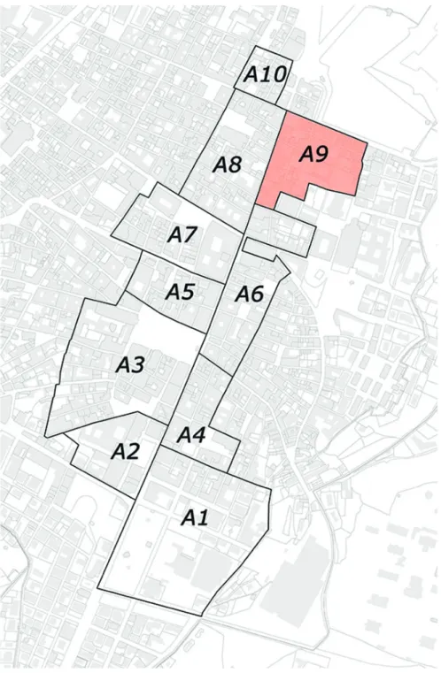
time it is also the most problematic area, because it has got all the main, unique features of Italian old towns: narrow alleys, structural units belonging to different historical periods, non-uniform construction techniquesetc. In addition to those singular features, there are also other features which distinguish an old town hit by an earthquake: the implementation of cumber some safety works, unstable buildings, ruins on the ground, restricted areas, but in particular the co-existence of many activities and subjects of a different kind (Firefighters, Army, citizens, technicians, designers, workers etc.). In order to manage at best the reconstruction of the central axis, the Municipality foreseen the partition of this area into compartments, each of whichhas got different dimensions and features.The compartments that make the central axis are 10, but itis take into account only the compartment number 9. (Fig.02)
The general construction site plan, besides giving informationon waysto start the work, includes the provision of criteria for intervention priority. More specifically, two priority levels are defined, one for compartments,the other for building aggregates. For what concerns the first level, it is take into account: the existence of main housesand commercial activities; the strategic positioning referred to the presence of wide areas that can be usedfor construction sites and to the presence of an adequate viability; the existence of collapses ordemolished/ that have to be demolished buildings. For what concerns the second priority level,we have to evaluate: the habitability results of each building aggregate; the location of the intervention, while taking into account the existence of widening and easily viable streets nearby the building aggregate; the intended use, by giving priority to houses and to commercial activities.
More in detail,the suggested general construction site plandevelops in two phases: exploratory phase and implementing phase.
Figure 4: Cranes plan, phase 1 Figure 5: Cranes plan, phase 2
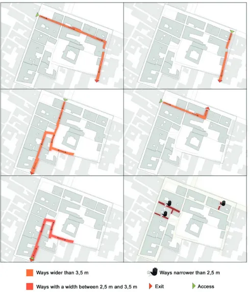
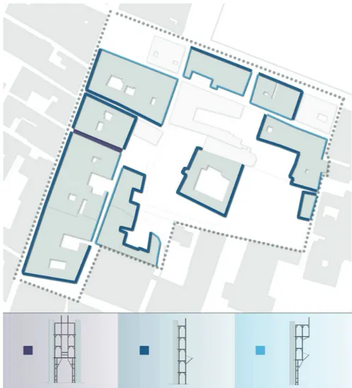
The exploratory phase of the plan The first step of the exploratory phaseincludes thecompartment framinginto the old town and the mapping of thehabitability results of each building aggregatethat constitutes it. After this, it must be identified the possible accesses to the compartment, directions of travel and the viable ways, of which must be reported the smallest dimension. In this way it is possible to establishwhich of them must be limited and to whatkind of means can circulate. In the compartment 9 it is possible to identify three typologies of way: ways narrower than 2,5 m, which could not circulate; ways with a width between 2,5 m and 3,5 m; finally,ways wider than 3,5 m. (Fig. 03)
Once having analyzed the viability it is possible to evaluate the existence of areasthat, considering dimensions and accessibility,can be used as operative logistic centersof construction sites within a compartment.In the same analysis are also taken into account all those smaller areas as, for example, courtyards, widening, small squares that can be destined to the installation of equipment and infrastructures of construction sites.
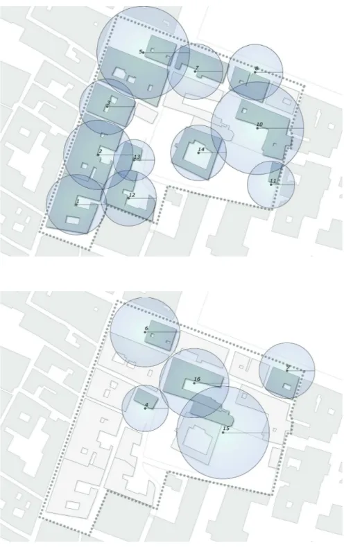
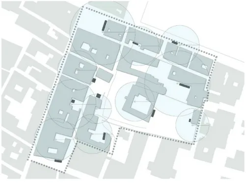
The implementing phase of the plan Knowing the frame ofcompartment features, in this stage it is possible to set the requirement concerning the building aggregates construction sites. Firstly, it must be defined the hypotheticlocation of cranes for each building aggregate, considering those as simultaneously active. Then,we proceed with the interferences evaluation: in case those do not allow to safely carry out the activities, we have to evaluate the priority of intervention among the examined building aggregates, by establishing which construction site should cease. In this way it is possible to define two stages of construction sitein which the requirements about the safety in the use of lifting machineries are met. (Fig. 04) (Fig. 05)
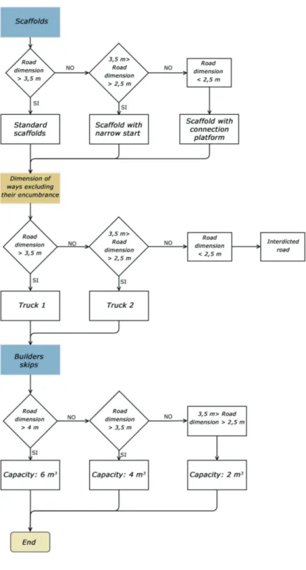
With reference only to the phase 1, the scaffolds typologies that guarantee an easy and safe viability for the construction site and first-aid vehicles are defined. Because of the existence of small ways, it is preferred
the use of scaffold with narrow start. The construction companies should respect the maximum dimensions of encumbrance that have been reported in the plan. (Fig. 06)
Figure 6: Typologies of considered scaffolds Once having defined the scaffold typologies, it must be calculated the dimension of ways excluding their encumbrance, in order to definethe typology and dimension of means that can circulate.
On the base of access viability to each construction site and of the areas destined to the setting up of those, it is established – approximately – the typology of temporary containers for rubble.
First of all, it is necessary to quantify the rubble generated for each building aggregate. Unfortunately it is not possible, for this kind of analysis, to access whole and truthful datato quantify the rubble production. To obtain an approximate esteem, then,at first it is
calculated the empty volume times full volume of buildings. After this, it must determined the incidence of rubble on m³ of a building, referring to the paperabout the esteem quantifying rubble drafted in 2010 by the Institute for Construction Technologies in cooperation with theNational Fire Department. In this document it is reported the incidence of the damage-extentlevel on the total rubble volumeon the ground. Because it has not been possible to definethe level of damageof each building in the data sheets AeDES, it has been considered the worst circumstance. Then, it has been associated to each building aggregate evaluated as condemned the higher level of damage.This, by following the directives of the above-mentioned
paper, affects the volume of rubble with a percentage of 1. You obtain, in this way, for each building,the approximate rubble volumethat it is possible to generate. Having obtained those results, while considering the dimension of builder skipsavailable on the market, it can be evaluatedthe necessary amount of those to be foreseen in each construction site, by taking into account the meters squaresfor each building aggregate and, in particular, on the base of the dimensionof the access way to this area.It is necessaryto evaluate which means can transit, by considering theencumbranceof scaffoldsand needed maneuver spaces and, by taking this into account, also the size of the builder skipthat has to be positioned. (Fig. 07) Integral element of the general construction site planis the rubble transport plan. For the rubble storage,the Municipality identifiedexternal areas to the construction site of L’Aquila, which have got the appropriate features for containing a great quantityof materialand that will be the “attraction points” towards which small vehicles coming from many working construction sites in the old town will head.In light of this, it is necessary to evaluate the traffic level of the vehicles that every day will carry the rubblefrom the construction site to the storage points, often located many kilometers away from the old town. For this reason three strategic choices have been developed:
1.
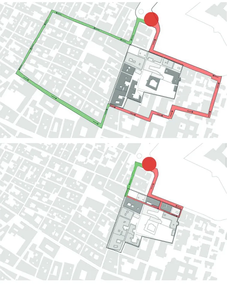
In order to lower as much as possiblethe ways overload, it is proposed the identification of temporary delivery points, near the old town, used by a variable number of compartments. The rubble coming from many construction sites will be drop off in those areas and later will be carried in storage areas identified by the Municipality, by bigger vehicles. After this, the central axis is divided into transit areasand for each one it is determined a temporary storage point and established the serviceviability. In making this partition, it has been followed the statement of the present directions of motion. Moreover, the logic behind the identification of the boundariesof each area based on the willing to guarantee a fair distribution of rubble quantity for each delivery point. (Fig. 08)
Once having set the transit areas, it is carried out an analysis on viability of means of the compartment n° 9, included in the transit area 1. More specifically, at this stage are analyzed the accessible routes that connect the contemplated compartment with the temporary delivery point. Then, two different ways are identified, on the base of the building aggregate location. Those are the only possible ways to be transited, in order to allow the rubble disposal. (Fig. 09) (Fig. 10)
2.
The second strategic choice refers to the transport means: it is considered, for each construction site, the use of a single mean . In this way there is the willing to reduce the environmental impact caused by the trafficof construction site means, but not only. The final aim is to lower the negative aspects related to the traffic of those kind of means in urban areas as, for example, traffic jam, the noise and atmospheric pollution and car accidents. It must be taken into account that only in the compartment 9 is contemplated, in the first phase, the simultaneity of 11 construction sites andcan be approximately foreseen the same number for all the other compartment of the central axis. It is clear, so,that the issue of rubble transportation must be facedby having the reduction of such a traffic as a priority, in order to better manage the rubble removal and to guarantee greater safety.3.
Finally, the choice connected with the production of rubble is strictly related to the one I mentioned above. By considering the transit of a single mean for each constructionFigure 7: Map of the builder skips
Figure 9: Route A Figure 10: Route B
Figure 11: Flow chart
site, it is necessary to identifyan upper limit of rubble quantity that can be generated, in order to guarantee their transportation within the workday. It is set for each aggregate: the means typology that is possible to use for the material transportation; the path length from the point of rubble loadingto the point of delivery and from this last one to the starting point; the time spent for loading/delivering the material is the same spent to cover the whole path. In this way it is possible to determinethe maximum rubble quantitythat can be carried in a workday and determining, accordingly, a demolition timeline. Those decisions let us obtain on the one hand asafer viability, both at a construction site level and at a urban level, considering also the presence of technicians, law enforcement and State military special forces. On the other hand,those choices zcause an extension of the work phases because of a slower waste disposal. This result, however, must be compared with the situation in which it is not foreseen a general construction site plan. Without it works would be faster, but with poor organization and left to the private initiative, while causing high trafficin the ways of the old town and more interferences among many adjacent construction sites.
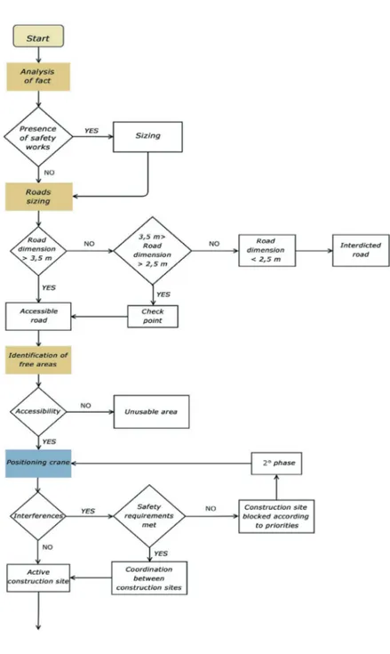
The activities included in the plan represent a sequence that can be standardized. The following flow chartresumes the choices, the analysis and the strategies depicted in this work, showing that the method can be applied to all the old towns hit by earthquakes. It is necessary to state that data used in this analysis are rough and often based on the event of the worst conditions. For this very reason, the plan realized for the compartment n.9 could be a model to create a real planning tool that can be applied as a valid alternative to the modus operandi of L’Aquila. (Fig. 11) (Fig. 12)
CONCLUSIONS
The requirements set for the compartment 9 can be extended and acted in all the compartments of the central axis.Through the implementation of the preliminary study included in the plan, in fact, it is possible to know the features of places, the major problems related to the construction site and to obtain a deeper knowledge of the
whole area. On the base of this,i twill be possible to set the guidelines, essential for the construction site, for working safely and for the disposal of waste materials.It will be identified, in relation with priority criteria, a first phase of construction site of the whole central axis,in which the interference among adjacent construction siteswill be few and managed easily. The reconstruction process will be more effective and, in particular, supervised by the municipal
authorities, who through the general construction site planwill be able to have a global vision on all the activities carried out in the old town. With the application of the guidelines the reconstruction site will be certainly be longer, but on the other hand it could be found to respond to one of the main problem of the L’Aquila case, that is the repopulation of the old town. Until now there are many case in which the owner of a restored private house is having to live in a place surrounded by many construction sites, without any services and consequently in an uninhabitable place. For this reason the strategic choices that distinguish the analysis of this plan aim both to enhance the use of public spaces and to make an homogeneous reconstruction process, well organized and set by following objective criteria. Providing for the contemporaneity of as many activities as possible, the plan allows for the reconstruction of several compartments at the same time.
The L’Aquila experience gives the possibility to employ new methods for the management of the reconstruction. This is why the general construction site plan represents an initial contribution to improve the procedures implemented in L’Aquila. It could be interesting to extend this method for all the most recent earthquake sites and so as to make the plan a procedure to be included in the competent activities of the public administrations.
Angeletti P., Cherubini A., Cifani G., De Marco R., Ferrini M., Fish G., Iacovone D., Lemme A., Petrini V., Fabrizi V., Santoro C., Miozzi C. (2013). La
Ricostruzione dei centri storici di L’Aquila e delle sue frazioni, L’Aquila.
Assessorato alla Ricostruzione e Pianificazione, Settore Pianificazione e Ripianificazione del territorio, Comune di L’Aquila. (2011). Il Piano di Ricostruzione dei centri storici di
L’Aquila e Frazioni, L’Aquila.
Assessorato alla Ricostruzione e Pianificazione, Settore Pianificazione e Ripianificazione del territorio, Comune di L’Aquila. (2011). Stralcio degli interventi edilizi diretti nella
perimetrazione del Capoluogo, L’Aquila.
Assessorato alla Ricostruzione, Comune di L’Aquila. (2013). Criteri operativi per la
programmazione della ricostruzione privata nei centri storici del comune di L’Aquila, L’Aquila.
Barbero M., L’emergenza e l’inerzia. Politica e
politiche dopo il sisma aquilano, Tesi di laurea,
Dipartimento di Scienze Politiche, Università LUISS Guido Carli.
Cazzaniga M. (ottobre 2009). “Un nuovo standard antisismico”, Il nuovo cantiere, n. 7.
Commissario delegato per la ricostruzione, a cura di. (2011). Piano per la gestione delle macerie
e rocce da scavo derivanti dagli interventi di prima emergenza e ricostruzione. L’Aquila, 2011.
De Lucia V., De Marco R., Josef G. F., Innocenzi R., Moretti M., Perrotti A., Seccia A. (2009).
L’Aquila. Non si uccide così anche una città?,
L’Aquila.
Decreto n. 3 del 9 marzo 2010 del Commissario Delegato per la Ricostruzione, Presidente della Regione Abruzzo.
Di Stefano, Pietro, a c. di. (2013). Criteri operativi
per la programmazione della ricostruzione privata nei centri storici del comune di L’Aquila. L’Aquila.
Dolce M., Manfredi G., a cura di. (2015). Libro
bianco sulla ricostruzione privata fuori dai centri storici nei comuni colpiti dal sisma dell’Abruzzo del 6 aprile 2009, Napoli: Doppiavoce Edizioni.
Frisch G. J., Il terremoto dell’Aquila. Pianificazione
dell’emergenza e urbanistica, Università di
Camerino, Facoltà di Architettura di Ascoli Piceno, 30 gennaio 2010.
Guizzardi R., (2010). Elementi di organizzazione del
cantiere e sicurezza nelle attività edili, Il mio libro.
ComitatusAquilanus, a cura di. (2009). L’Aquila.
Non si uccide così anche una città?. L’Aquila.
Legge 77 del 24 giugno 2009, Conversione in legge, con modificazioni, del Decreto Legge n. 39 del 28 aprile 2009, recante interventi urgenti in favore delle popolazioni colpite dagli eventi sismici
Bibliography
Web sites
nella regione Abruzzo nel mese di aprile 2009 e ulteriori interventi urgenti di protezione civile, pubblicata nella Gazzetta Ufficiale n. 147 del 27 giugno 2009.
Linee di indirizzo strategico per la ripianificazione del territorio, a cura della Struttura Tecnica di Missione, L’Aquila, 20 luglio 2010.
Mengoli G. C. (2014). Manuale di diritto
urbanistico, Giuffrè.
Picone M. (1984). Tecnologia della produzione
edlizia metodiche industriali e tecnologie operative per i cantieri edili. Torino: UTET.
Protocollo di intesa Emergenza sisma Abruzzo 2009: ottimizzazione delle attività relative alle misure per la salute e sicurezza nei cantieri temporanei o mobili, L’Aquila, 30 novembre 2009.
Severino M., Di Pasquale R. (2002). Procedure
per la ricostruzione post-sisma: analisi e proposte,
Dipartimento della protezione civile.
Settore Pianificazione e Ripianificazione del territorio, Settore Emergenza e Ricostruzione privata, a cura di. (2011). Osservazioni sul sistema dell’emergenza per una disciplina organica per l’esecuzione degli interventi nei centri storici colpiti dal sisma del 2009. L’Aquila. Utica G. (2009). Progettazione esecutiva,
progettazione operativa e sicurezza nei cantieri,
Maggioli editore. http://www.commissarioperlaricostruzione.it http://www.comune.laquila.gov.it http://www.comune.villasantangelo.aq.it http://www.esecptlaquila.it http://www.protezionecivile.gov.it http://www.usra.it http://www.usrc.it http://www.vigilfuoco.it