GROTTA ROMANELLI (SOUTHERN ITALY, APULIA): LEGACIES AND ISSUES IN EXCAVATING A KEY SITE FOR THE PLEISTOCENE OF THE MEDITERRANEAN
RAFFAELE SARDELLA1,4, ILARIA MAZZINI2, FRANCESCA GIUSTINI2,
BENIAMINO MECOZZI1,4, MAURO BRILLI2, DAWID ADAM IURINO1,4, GIUSEPPE LEMBO3,
BRUNELLA MUTTILLO3, MASSIMO MASSUSSI4, DARIO SIGARI5, SONIA TUCCI4 &
MARIO VOLTAGGIO2
1Dipartimento di Scienze della Terra, Sapienza Università di Roma, Piazzale A. Moro, 5 - 00185 Roma, Italy. PaleoFactory, Sapienza Università
di Roma, Piazzale A. Moro, 5 - 00185 Roma, Italy. Email: [email protected]; [email protected]; [email protected]
2Istituto di Geologia Ambientale e Geoingegneria (IGAG), CNR, Area della Ricerca di Roma RM1, Via Salaria km 29,300, 00016 Monterotondo,
Roma, Italy. Email: [email protected]; [email protected]; [email protected]; [email protected]
3Dipartimentodi Studi Umanistici, Sezione di Scienze Preistoriche e Antropologiche, Università degli Studi di Ferrara, LT, TekneHub, 44121
Ferrara, Italy. Email: [email protected], [email protected]
4PaleoFactory, Sapienza Università di Roma, Piazzale A. Moro, 5 - 00185 Roma, Italy. E-mail: [email protected]; [email protected] 5Erasmus Mundus Quaternary and Prehistory - Dipartimento di Studi Umanistici, Sezione di Scienze Preistoriche e Antropologiche, Università
degli Studi di Ferrara, LT, TekneHub, 44121 Ferrara, Italy; Universitat Rovira I Virgili Institut de Paleoecologia Humana i Evolució Social (IPHES), C/ M. Domingo S/N Edifici W3, 43007 Tarragona, Catalunya-España. Email: [email protected]
To cite this article: Sardella R., Mazzini I., Giustini F, Mecozzi B., Brilli M., Iurino D.A., Lembo G., Muttillo B., Massussi M., Sigari D., Tucci S. & Voltaggio M. (2018) - Grotta Romanelli (Southern Italy, Apulia): legacies and issues in excavating a key site for the Pleistocene of the Mediterranean.
Riv. It. Paleontol. Strat., 124(2): 247-264.
Abstract. Grotta Romanelli, located on the Adriatic coast of southern Apulia (Italy), is considered a key site for the Mediterranean Pleistocene for its archaeological and palaeontological contents. The site, discovered in 1874, was re-evaluated only in 1900, when P. E. Stasi realised that it contained the first evidence of the Palaeolithic in Italy. Starting in 1914, G.A. Blanc led a pioneering excavation campaign, for the first-time using scientific methods applied to systematic palaeontological and stratigraphical studies. Blanc proposed a stratigraphic framework for the cave. Different dating methods (C14 and U/Th) were used to temporally constrain the deposits. The extensive
studies of the cave and its contents were mostly published in journals with limited distribution and access, until the end of the 1970s, when the site became forgotten. In 2015, with the permission of the authorities, a new excavation campaign began, led by a team from Sapienza University of Rome in collaboration with IGAG CNR and other research institutions. The research team had to deal with the consequences of more than 40 years of inactivity in the field and the combined effect of erosion and legal, as well as illegal, excavations. In this paper, we provide a database of all the information published during the first 70 years of excavations and highlight the outstanding problems and contradictions between the chronological and geomorphological evidence, the features of the faunal assemblages and the limestone artefacts.
Received: August 16, 2017; accepted: February 13, 2018 Keywords: biochronology; Mousterian; MIS5; Middle-Late Pleistocene.
I
ntroductIonThe Otranto-Santa Maria di Leuca Coast and Bosco di Tricase regional nature park (Apulia Italy) protects more than 50 km of coastline, punctuated by caves that open onto the steep coastline or are submerged beneath the present sea level. Numerous caves contain a remarkable archive of palaeon-tological, archaeological and palaeoclimatic data (Mastronuzzi et al. 2007). For instance, Zinzulusa Cave is a well-known geoheritage site and is visited
annually by approximately 100,000 people. Grotta Romanelli (GR), although considered of extreme importance for its archaeological and palaeonto-logical content, is difficult to access, being isolated and located 7.4 m above sea level (asl). The cave is filled with thick deposits rich in fossil remains and artefacts. Ulderico Botti discovered the cave in 1874 and in 1900 P.E. Stasi realised its remarkable im-portance as the first evidence for the Palaeolithic in Italy. In 1914, G.A. Blanc started an excavation campaign, collecting and archiving archaeological and palaeontological material. The rich fossil assem-blage and a wide variety of artefacts collected in the
sediments of GR have been dispersed to different museums and institutions from the early stages of the excavations. These collections are the only avail-able source of data for more recent studies (Piperno 1974; Cassoli et al. 1979; Di Stefano et al. 1992; Fabri 2003; Spinapolice 2008; Mussi & De Marco 2008; Sardella et al. 2014).
Despite decades of research, many issues need to be investigated and clarified regarding the age of the lower deposits due to the apparent con-tradiction between the supposed archaic nature of the Mousterian artefacts and the vertebrate fauna (Piperno 1974). In 2013, an analysis of the fossil carnivores from GR began (Sardella et al. 2014). In 2015, reopening of the excavations after more than 40 years broke the spell of inactivity in the field.
G
eoloGIcal settInGThe Salentine peninsula (SP), the southeast-ern tip of Apulia, is a lowland area, part of the Apulia carbonate platform representing the south-ern Apennine foreland. It is mainly composed of Jurassic-Cretaceous limestones and dolostones capped by Neogene to Quaternary sediments stretching between the Adriatic and Ionian Seas (Fig. 1).
From the Late Cretaceous to the Early Pleistocene, the SP developed a horst and graben structure due to the microplates involved in the convergence of the Apenninic and Dinaric chains
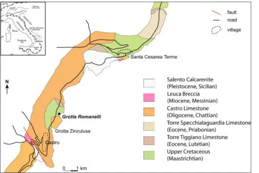
(Funiciello et al. 1991). Other major faults trend between NE-SW and NNE-SSW trends. Due to the predominance of outcrops of calcareous rocks, the morphology of the Salento Peninsula is charac-terised by karstic landforms. The last phase of de-velopment of karst features started in the Middle Pleistocene with the tectonic uplift of the Puglia region (Doglioni et al. 1994; Santaloia et al. 2016). These karstic processes have given rise to many caves, some located along the coastline. From S. Cesarea Terme to Tricase Porto, the caves open in the Castro Limestone (Upper Oligocene). An ex-ception is the “stratigraphic window” (Bosellini et al. 1999) of the Romanelli Bay (Fig. 1) where the Ciolo Limestone (Upper Cretaceous) crops out along the coast and where GR opens at about 7.4 m asl (Fig. 2a). The Ciolo Limestone is a coarse bio-clastic calcarenite-calcirudite; the bioclasts are frag-ments of rudists, corals, bryozoans, calcareous algae and large foraminifera, including orbitoids pointing to a late Maastrichtian age (Bosellini & Parente 1994). Along the southwestern part of the bay, the Torre Specchialaguardia Limestone (Priabonian, Upper Eocene, Parente 1994), representing a steep forereef slope onlapping on the rocky Cretaceous, and the Castro limestone (Chattian, Bosellini & Russo 1994), a fringing reef complex, are clinos-tratified above the Ciolo Limestone, which presents two different facies (Fig. 2b).
The Miocene to Quaternary (Calabrian) ma-rine deposits crop out more inland with respect to the GR area (Bossio et al. 2005). Terra Rossa soils Fig. 1 - Geographical location of Grotta Romanelli and sche-matic geological map of the area (modified from Boselli-ni et al. 1999).
crop out extensively on coastal cliff tops and on inland limestone surfaces (Bossio et al. 2005). The term Terra Rossa indicates a kind of reddish clay-ey to silty-clayclay-ey material, which occurs above lime-stone and dolomite in the form of a discontinuous layer (Xiao et al. 2013); Terra Rossa soil is widespread in regions characterised by a Mediterranean climate and is particularly common in the Apulia region (Moresi & Mongelli 1988; Bellanca et al. 1996). Thick slope deposits made by coarse graviclastic breccia in a reddish matrix, or completely clast supported oc-cur along the coast and are particularly thick along Romanelli Bay (Mastronuzzi et al. 2007) (Fig. 2b). Their formation has been related to cold-arid climat-ic conditions (Mastronuzzi et al. 2007). These depos-its grade upwards to thinly laminated sands that have been correlated to those cropping out near Capo d’Otranto, where Helicidae have been collected and dated (AMS radiocarbon age 27.615±345 years BP [GX-18123-AMS], Mastronuzzi et al. 2007).
G
eomorpholoGIcalsettInGThe coastal slope between Otranto and Leuca is characterised by five abrasion platforms at
about 50-60, 40, 15-20 and 8-10 m asl, respectively (Mastronuzzi et al. 2007). The submerged part of the coastal slope is interrupted by two platforms, at about 5 m and between 7 and 10 m below sea level, and by a wide plain stretching offshore below 20 m depth.
The lowermost surface is evident at GR as a platform at about 7.4 m asl. Lithophaga boreholes
and a notch with algal incrustations occur on the northern part of the entrance wall at about 8-10 m asl (Blanc 1920). Blanc (1920) reported potholes on the terrace, in some of which he found remains of marine mollusks: Patella lusitanica Gmelin (= P. rustica Linnaeus); Conus mediterraneus Brugiere (= C. ventricosus Gmelin); Trochus umbilicaris Linnaeus
(= Gibbula umbilicaris [Linnaeus]); Littorina neritoides
(Linnaeus) (= Melarhaphe neritoides [Linnaeus]),
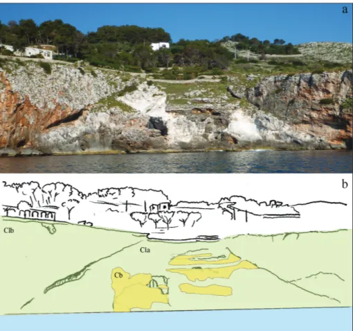
pum-ices and pebbles, and referred these thin depos-its to a coastal/beach environment related to the Tyrrhenian Stage (MIS5). This firmly constrained the whole sequence to the Late Pleistocene (Blanc 1920, 1928). Cosentino & Gliozzi (1992) support-ed this hypothesis and referrsupport-ed the terrace of GR to the last interglacial. Hearty and Dai Pra (1992) reported a Tyrrhenian sea level at 10m asl in this area. However, Mastronuzzi et al. (2007) proposed Fig. 2 - The Grotta Romanelli bay: (a)
panoramic photo of the bay (photo by Ilaria Mazzini); (b) geological sketch of the bay. The light green colour indicates the Cretaceous li-mestone (Late Senonian, Cl, Ciolo limestones of Fig. 1), the light-yellow colour indi-cates the Pleistocene-Holo-cene (?) calcareous breccia (Cb). The cave opens in ma-trix-supported limestones, with planktonic foraminifera and fine detrital grains (Cla). The facies change to bio-cla-stic limestones with rudists and orbitoids is shown by the clinostratification (Clb).
a different model for the development of the coast-al caves coast-along the Otranto-Leuca coast, over the last 400 ka. They proposed a phase of uplift occur-ring duoccur-ring the Early Pleistocene and/or the early Middle Pleistocene that could explain the abrasion platforms seen along the Otranto-Leuca coast.
p
revIousstudIesGrotta Romanelli has been the subject of 146 years of discontinuous excavations and research. The data, results and interpretations of the palae-ontological, archaeological, chemical and sedimen-tological data were often published in local or minor journals and are here summarised for the first time. Inside the cave, a thick deposit made of breccia, red soils and stalagmitic layers hosts a rich assem-blage of fossils and archaeological artefacts that has been the object of several excavation campaigns. To avoid confusion, in the present paper we use Terra Rossa to indicate red soils and “terre rosse” and “terre brune” to indicate the infilling sediments of the cave, accepting the terminology used by Blanc (1920).
The history of the excavations
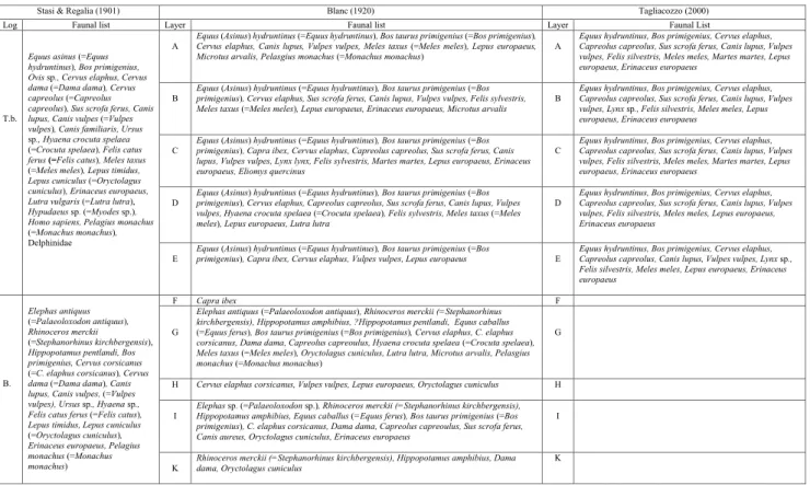
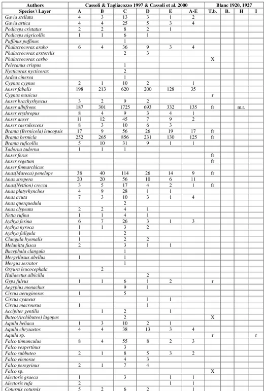
In 1874, during a campaign of investigation on behalf of the Provincial Deputation of Terra d’ Otranto aimed at identifying sites of archaeolog-ical and palaeontologarchaeolog-ical interest, Ulderico Botti be-came aware of a cave, close to Zinzulusa Cave and called Grotta Romanelli. Botti (1874) described the cave as inaccessible due to an unconsolidated de-posit that filled the entrance almost completely and he therefore focused his interest on the breccia out-side the cavity, publishing the fossil materials con-tained therein. In 1900, Paolo Emilio Stasi directed attention to the infilling deposits of the cave and their rich palaeontological and archaeological con-tent (Stasi & Regalia 1904). These authors carried out the first palaeontological studies on the remains found in the infilling sediments and demonstrated the great importance of the site as the first record of the Palaeolithic in Italy. The authors divided the sedimentary sequence into two parts, the so called “terre brune” in the upper part, containing fossil remains representing a cold-climate vertebrate fau-nal assemblage, and the so called “Bolo” or “terre rosse” in the lower part, containing a more diverse vertebrate fauna (Tab. 1). This discovery had great Tab. 1 - List of the mammal fauna from the Grotta Romanelli deposits (modified from Stasi & Regalia 1901; Blanc 1920; Tagliacozzo 2000).
Layer refers to the stratigraphic layers as reported in Fig. 3. T.b. = “terre brune”. B.= “bolo” or “terre rosse”.
Stasi & Regalia (1901) Blanc (1920) Tagliacozzo (2000)
Log Faunal list Layer Faunal list Layer Faunal List
T.b.
Equus asinus (=Equus hydruntinus), Bos primigenius, Ovis sp., Cervus elaphus, Cervus dama (=Dama dama), Cervus capreolus (=Capreolus capreolus), Sus scrofa ferus, Canis lupus, Canis vulpes (=Vulpes vulpes), Canis familiaris, Ursus sp., Hyaena crocuta spelaea (=Crocuta spelaea), Felis catus ferus (=Felis catus), Meles taxus
(=Meles meles), Lepus timidus, Lepus cuniculus (=Oryctolagus cuniculus), Erinaceus europaeus, Lutra vulgaris (=Lutra lutra), Hypudaeus sp. (=Myodes sp.), Homo sapiens, Pelagius monachus (=Monachus monachus), Delphinidae
A Equus (Asinus) hydruntinus (=Equus hydruntinus), Bos taurus primigenius (=Bos primigenius), Cervus elaphus, Canis lupus, Vulpes vulpes, Meles taxus (=Meles meles), Lepus europaeus, Microtus arvalis, Pelasgius monachus (=Monachus monachus) A
Equus hydruntinus, Bos primigenius, Cervus elaphus, Capreolus capreolus, Sus scrofa ferus, Canis lupus, Vulpes vulpes, Felis silvestris, Meles meles, Martes martes, Lepus europaeus, Erinaceus europaeus
B Equus (Asinus) hydruntinus (=Equus hydruntinus), Bos taurus primigenius (=Bos primigenius), Cervus elaphus, Sus scrofa ferus, Canis lupus, Vulpes vulpes, Felis sylvestris, Meles taxus (=Meles meles), Lepus europaeus, Erinaceus europaeus, Microtus arvalis B
Equus hydruntinus, Bos primigenius, Cervus elaphus, Capreolus capreolus, Sus scrofa ferus, Canis lupus, Vulpes vulpes, Lynx sp., Felis silvestris, Meles meles, Lepus europaeus, Erinaceus europaeus
C Equus (Asinus) hydruntinus (=Equus hydruntinus), Bos taurus primigenius (=Bos primigenius), Capra ibex, Cervus elaphus, Capreolus capreolus, Sus scrofa ferus, Canis lupus, Vulpes vulpes, Lynx lynx, Felis sylvestris, Martes martes, Lepus europaeus, Erinaceus europaeus, Eliomys quercinus
C Equus hydruntinus, Bos primigenius, Cervus elaphus, Capreolus capreolus, Sus scrofa ferus, Canis lupus, Vulpes vulpes, Felis silvestris, Meles meles, Martes martes, Lepus europaeus, Erinaceus europaeus
D Equus (Asinus) hydruntinus (=Equus hydruntinus), Bos taurus primigenius (=Bos primigenius), Cervus elaphus, Capreolus capreolus, Sus scrofa ferus, Canis lupus, Vulpes vulpes, Hyaena crocuta spelaea (=Crocuta spelaea), Felis sylvestris, Meles taxus (=Meles meles), Lepus europaeus, Lutra lutra
D Equus hydruntinus, Bos primigenius, Cervus elaphus, Capreolus capreolus, Sus scrofa ferus, Canis lupus, Vulpes vulpes, Felis silvestris, Meles meles, Lepus europaeus, Erinaceus europaeus
E Equus (Asinus) hydruntinus (=Equus hydruntinus), Bos taurus primigenius (=Bos primigenius), Capra ibex, Cervus elaphus, Vulpes vulpes, Lepus europaeus E Equus hydruntinus, Bos primigenius, Cervus elaphus, Capreolus capreolus, Canis lupus, Vulpes vulpes, Lynx sp., Felis silvestris, Meles meles, Lepus europaeus, Erinaceus europaeus B. Elephas antiquus (=Palaeoloxodon antiquus), Rhinoceros merckii (=Stephanorhinus kirchbergensis), Hippopotamus pentlandi, Bos primigenius, Cervus corsicanus (=C. elaphus corsicanus), Cervus dama (=Dama dama), Canis lupus, Canis vulpes, (=Vulpes vulpes), Ursus sp., Hyaena sp., Felis catus ferus (=Felis catus), Lepus timidus, Lepus cuniculus (=Oryctolagus cuniculus), Erinaceus europaeus, Pelagius monachus (=Monachus monachus)
F Capra ibex F
G
Elephas antiquus (=Palaeoloxodon antiquus), Rhinoceros merckii (=Stephanorhinus kirchbergensis), Hippopotamus amphibius, ?Hippopotamus pentlandi, Equus caballus (=Equus ferus), Bos taurus primigenius (=Bos primigenius), Cervus elaphus, C. elaphus corsicanus, Dama dama, Capreolus capreoulus, Hyaena crocuta spelaea (=Crocuta spelaea), Meles taxus (=Meles meles), Oryctolagus cuniculus, Lutra lutra, Microtus arvalis, Pelasgius monachus (=Monachus monachus)
G
H Cervus elaphus corsicanus, Vulpes vulpes, Lepus europaeus, Oryctolagus cuniculus H I Elephas sp. (=Palaeoloxodon sp.), Rhinoceros merckii (=Stephanorhinus kirchbergensis), Hippopotamus amphibius, Equus caballus (=Equus ferus), Bos taurus primigenius (=Bos
primigenius), C. elaphus corsicanus, Dama dama, Capreolus capreoulus, Sus scrofa ferus, Canis aureus, Oryctolagus cuniculus, Erinaceus europaeus
I
international significance and gave rise to a heated debate among important personalities of the time, such as L. Pigorini, A. Mochi, H. Breuil and E. Cartilhac (Ingravallo 2003).
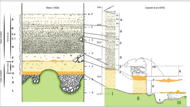
In 1914, G.A. Blanc began a pioneering ex-cavation campaign, during which the first system-atic archaeological/palaeontological and strati-graphic study using scientific methods was carried out. Blanc (1920) carried out a careful study of the stratigraphy (Fig. 3) and of the faunal assemblages (Tab. 1) in each layer. He extensively studied the in-filling deposits (Fig. 3) and distinguished: the upper complex, the “terre brune” (layers A-E) (360 cm) bearing upper Palaeolithic tools and a cold climate vertebrate fauna including Pinguinus impennis (= Alca impennis in Blanc 1927); the stalagmitic layer F (0-5
cm); the lower complex (G-K), including the “terre rosse” (60-80 cm), bearing a diversified vertebrate fauna (including Palaeoloxodon antiquus, Hippopotamus amphibius and other taxa, see Tab. 1) and Mousterian
limestone artefacts, the stalagmitic layer H (20 cm), the bone breccia (0-100 cm) and the beach deposits (0-60 cm) (Blanc 1920, 1928; Piperno 1974). Blanc (1920) considered layer F as the boundary between two worlds, characterised by different climates and thus different fossils and lithic tools. Outside the
cave, a breccia rich in vertebrate remains partially closed the entrance and was related either to lay-er F or to the undlay-erlying stalagmitic laylay-er (laylay-er H) (Blanc 1928; Cassoli et al. 1979). Blanc suggested that the fossil remains from the lower part (layers G-K) could pertain to warm climatic conditions whereas the stalagmitic layer H represented a hu-mid and possibly cold period. In contrast, the fauna recovered from the “terre brune” indicated cold cli-matic conditions. Furthermore, he pointed out the crucial importance of the stalagmitic layer F as the boundary marking the passage from warm to cold climatic conditions. Blanc’s excavations were at-tended by eminent scholars such as the Abbé Breuil, L. Cardini, H. Obermaier, Blanc’s son, who from 1954 directed the excavations alongside his father, P. Cassoli and P. Graziosi, many of them members of the Italian Institute of Human Paleontology (IsIPU). During the 1960s, several excavation cam-paigns were carried out by the IsIPU, under the di-rection of Cardini (Blanc et al. 1962; Cardini 1963; Cardini & Biddittu 1967) with the participation of M. Piperno, I. Biddittu, G. Carancini, P. Cassoli and M. Taschini. The Salentine Speleological Group pro-vided support during these excavations. The main stratigraphic and lithic industry data were synthe-Fig. 3 - Stratigraphy of the Grotta Romanelli infilling deposits (from Blanc 1928 & Cassoli et al. 1979, coloured). The original lettering of the in-filling deposits is shown (Blanc 1920) together with the subdivision used in this paper. The horizontal lines indicate the stalagmitic layers.
sized in Piperno (1974), who ascribed several fossils coming from the base of the “terre rosse” to Capra ibex. Moreover, he suggested that these finds could
be associated with the same climatic conditions in which the underlying layer (layer H) was deposited.
Sedimentology and geochemistry of the cave deposits
The sedimentology and geochemistry of the infilling deposits of Grotta Romanelli were dis-cussed in numerous studies (Blanc 1938; Blanc & Cortesi 1941; Lazzari 1955; Cortesi 1958; Garavelli et al. 1974).
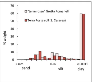
The sedimentological characterization showed that the “terre rosse” and “terre brune” are mainly composed of clay, which represents the 59% of the sediments (Fig. 4) (Cortesi 1958). The mineral-ogy of the “terre rosse” is represented by quartz, which is the principal mineral constituent in the coarser grain size, where many other mineral phas-es were also recognized: chalcedony (radiolarians and unidentified biogenic fragments), glauconite, feldspars, kaolinite, oxides and hydroxides. The fraction below 0.02 mm revealed the presence of siltose quartz and an increasing quantity of clay minerals of the illite and kaolinite groups. On the basis of these findings Cortesi supported an eolian origin for these deposits, as Blanc (1920) had already contended using microscopic obser-vation that revealed rounded and abraded quartz.
Nevertheless, a certain contribution of water (of varying nature) to the deposition process was not completely excluded because of the presence of glauconite, chalcedony, and Fe-Mn concretions.
The principal geochemical features reviewed are listed in Table 2 (Blanc 1938; Blanc & Cortesi 1941; Cortesi 1958). The “terre brune” and “terre rosse” deposits are chemically very similar; this may point to the same genesis for these deposits. The carbonate content was about 10-15 wt.% by Fig. 4 - Histograms of grain size distribution of “terre rosse” from Grotta Romanelli and Terra Rossa soil that crops out at S. Cesarea Terme (from Cortesi 1958).
Sample Grain size (mm) Ref. SiO2 Al2O3 Fe2O3 CaO MgO Na2O K2O MnO TiO2 P2O5 H2O Carbonates Total Humic acids pH SSR Level I < 2 a, b 18.42 11.25 3.13 32.32 1.65 0.01 tr. 0.01 0.35 34.37 101.51 0.08-0.12 9.3 2.36 Level G < 2 a, b 56.10 16.71 8.04 6.4 0.15 tr. 0.01 0.09 0.92 13.02 101.44 0.24 7.5 1.71 Level A-E < 2 a, b 49.00 21.77 9.89 2.25 0.1 tr. – 0.12 0.81 15.25 99.19 2.3-2.7 7.2 1.76 Level I < 0.002 a, b 51.19 25.22 4.71 1.35 tr. tr. tr. 0.07 0.88 15.54 98.96 0.12 Level G < 0.002 a, b 45.10 32.39 10.12 0.1 tr. – tr. 0.11 1.05 10.15 99.02 0.32 Level A-E < 0.002 a, b 43.65 32.75 10.8 0.15 – tr. 0.01 0.17 0.95 13.60 102.08 1.05 Level G 0.02-0.055 c 78.05 9.48 4.42 0.5 0.08 1 3 0.25 1.4 0.1 1.98 100.26 1.07 Level G 0.055-0.0028 c 67.96 13.77 6.82 0.5 0.4 0.65 3.3 0.5 1.7 0.2 4.1 99.90 1.37 Level G 0.0028-0.002 c 63.66 16.41 7.31 0.3 0.6 0.45 3.5 0.5 1.8 0.2 5.28 100.01 1.57 Level G 0.002-0.0014 c 60.13 19.17 7.13 0.5 0.7 0.4 3.6 0.5 1.9 0.2 5.82 100.05 1.75 Level G 0.0014-0.0011 c 55.25 22.21 7.94 0.45 1.2 0.3 3.6 0.7 1.8 0.2 6.8 100.45 1.82 Level G <0.0011 c 44.94 29.55 10.51 0.1 0.76 0.8 2.9 0.1 0.9 0.5 9.11 100.17 2.02 Level G <0.0011 c 44.97 29.68 9.86 0.1 0.29 1.1 3 0.1 0.9 0.6 10 100.6 2.06 Level G <0.0011 c 44.54 30.09 10.73 0.1 0.61 0.8 2.4 0.03 0.9 0.7 9.5 100.4 2.01 Level G <0.0011 c 44.86 30.06 10.88 0.1 0.74 0.6 2.8 0.1 0.9 0.1 9.02 100.16 2.02 TR soil 0.02-0.055 c 79.91 7.50 5.41 0.6 0.1 0.5 1.8 0.07 1.4 0.2 2.1 99.59 1.16 TR soil 0.055-0.0028 c 68.65 13.03 8.55 0.5 0.6 0.3 1.95 0.08 1.9 0.25 4.48 100.29 1.62 TR soil 0.0028-0.002 c 62.57 16.15 8.64 0.1 0.8 0.3 2.2 0.08 2.2 0.3 6.3 99.64 1.70 TR soil 0.002-0.0014 c 59.04 19.86 8.38 0.1 0.2 0.5 2.65 0.1 2.2 0.34 6.88 100.25 1.63 TR soil 0.0014-0.0011 c 52.91 22.63 10.61 0.1 1.2 0.8 2.95 0.1 2.2 0.4 6.8 100.7 1.65 TR soil <0.0011 c 45.14 30.62 10.54 0.07 0.78 0.45 2.3 0.04 0.9 0.04 9.55 100.43 2.01 TR soil <0.0011 c 44.85 30.33 10.92 0.07 1.32 0.6 2.2 0.02 0.9 0.02 9.3 100.53 2.01 TR soil <0.0011 c 43.89 30.65 10.5 0.1 1.11 0.4 2.8 0.1 0.9 0.1 9.76 100.31 1.96 TR soil <0.0011 c 44.18 30.43 10.84 0.07 1.18 0.4 2.2 – 0.8 – 9.87 99.97 1.99
Tab. 2 - Major element content, humus level, pH values, and silica/sesquioxide ratios [SSR= (SiO2/60)/(Al2O3/102) + (Fe2O3/160)] of bulk, silt and clay fractions of samples from Grotta Romanelli (Layers I, G and A-E) and from Terra Rossa soil of S. Cesarea Terme (TR soil). All the major element values are in weight percent. Ref.: (a) Blanc 1938 (II), (b) Blanc & Cortesi 1941, (c) Cortesi 1958.
weight, which Blanc (1938) and Blanc & Cortesi (1941) contended mostly derived from erosion of the limestone of the cave’s vault and, in turn, influ-enced the soil pH values (Tab. 2). The “terre brune” showed a relatively high percentage of humic acids (~2.5 wt.%), which conferred the brownish colour on the deposit and was related to a phase of cold climate with slow decomposition of organic matter. A lower content of humic acids was measured in the “terre rosse” (~0.3 wt.%).
The “terre rosse” of GR and S. Cesarea Terme are similar with respect to chemical and mineralogical composition, as well as particle size distribution (Fig. 4). Cortesi (1958) attributed this similarity to a common origin.
In summary, according to the previous stud-ies, the sediments of the “terre brune” and “terre rosse” were mainly considered to have an eolian origin. They are predominantly composed of argil-laceous material and, to a lesser degree, of quartz, which dominates the coarser fraction of the entire sedimentary body. These deposits may represent different climatic and environmental conditions.
Volcanic and organic deposits
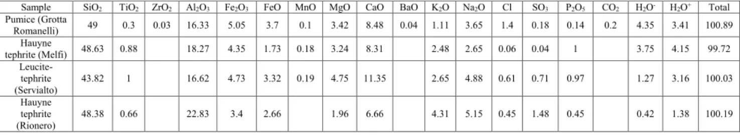
Other minor deposits have been identified in the Romanelli cave, such as the K layer report-ed by Blanc (1938), characterizreport-ed by pumice frag-ments and a pumice lenticular deposit, 15 cm thick at most, which lies on the bedrock. The latter was identified by Lazzari (1955) who related it to the Mt. Vulture volcanic eruptions. Cortesi (1958) also at-tributed the presence of pumice to the Mt. Vulture volcano eruptions, to justify the occurrence of trac-es of ilmenite and titanite in the sediments. The lay-er identified by Lazzari (1955) consists of round-ed pumice fragments, with a diameter of 2-18 mm and reddish in colour in the upper part of the layer, perhaps due to the oxidation of iron compounds. Chemical analysis confirmed that alteration affected
this material (Tab. 3).
Finally, several crystals of mellite, a rare min-eral typically associated with lignite deposits, were identified within a carbonaceous layer considered as the remnant of a hearth of Palaeolithic age and interbedded in the “terre rosse” deposit (Garavelli et al. 1974).
The palaeontological data
In the 1990s, the archaeozoological labo-ratory of the Pigorini Museum (Rome) began a detailed study of the fossil bird remains from the “terre brune” (layer A-E) (Cassoli 1992; Cassoli & Tagliacozzo 1997; Cassoli et al. 2003; Tagliacozzo & Gala 2000, 2001; Gala & Tagliacozzo 2010). One hundred and nine different species were identified on the basis of about 32.200 fossil remains, rep-resenting the largest osteological sample of birds from the Italian Palaeolithic (Tab. 4, Cassoli & Tagliacozzo 1997). The analysis of the sample high-lighted the prevalence of temperate species (75% of the remains), mainly representing steppic and grassland environments (72.6%). The occurrence of North Atlantic and subarctic marine species (23%), such as Pinguinus impennis, was also reported
(Cassoli et al, 2003). Fish remains were also report-ed for the first time from the “terre brune” (Tab. 5) (Blanc 1920; Cassoli et al. 2003).
Tagliacozzo (2003) focused on the fossil mammal remains coming from the “terre brune” (layer A-E) (Fig. 3). His review of these remains highlighted that several species were mistakenly re-ported by Blanc (1920, 1928), such as Crocuta cro-cuta spelaea, Lutra lutra and Capra ibex. At present,
the majority of data available about the mammal fauna assemblage from the “terre rosse” (layer G) are those reported by Blanc (1920). Only the canid and rhino remains from the “terre rosse” (layer G) were recently described by Sardella et al. (2014) and Pandolfi et al. (2017) respectively.
Sample SiO2 TiO2 ZrO2 Al2O3 Fe2O3 FeO MnO MgO CaO BaO K2O Na2O Cl SO3 P2O5 CO2 H2O- H2O+ Total Pumice (Grotta Romanelli) 49 0.3 0.03 16.33 5.05 3.7 0.1 3.42 8.48 0.04 1.11 3.65 1.4 0.18 0.14 0.2 4.35 3.41 100.89 Hauyne tephrite (Melfi) 48.63 0.88 18.27 4.35 1.73 0.18 3.24 8.31 2.48 2.65 0.06 0.04 1 3.75 4.15 99.72 Leucite-tephrite (Servialto) 43.82 1 16.62 4.73 3.32 0.19 4.75 11.35 2.65 4.88 0.61 0.71 0.97 1.27 3.16 100.03 Hauyne tephrite (Rionero) 48.38 0.66 22.83 3.4 2.66 1.96 6.66 4.31 5.15 0.45 1.48 0.45 0.42 1.38 100.19
Tab. 3 - Chemical composition of pumice from Grotta Romanelli and other volcanic products from Mt. Vulture volcano. Data from Lazzari (1955).
The canid remains from layer G are of spe-cial interest because of their peculiar features. Blanc (1920) referred skulls and other skeletal ele-ments to Canis lupus and, tentatively, to the golden
jackal Canis aureus and referred the same remains
to the golden jackal in a palaeoenvironmental study (Blanc 1928). Later, different authors (Masini et al. 1990; Sala et al. 1992) discussed the taxonomy of the Romanelli “wolf ” that, given its size and mor-phology, could be referred to the Early-Middle Pleistocene small-sized wolf Canis mosbachensis.
The co-occurrence of large mammals (elephants, hippos and rhinos; Table 1) and lithic artefacts with supposed archaic features led Masini et al. (1990) and Sala et al. (1992) to suggest an older age for the lower layers. On the other hand, Blanc (1920) and Mastronuzzi et al. (2007) constrained the terrace at the base of the cave deposits to MIS 5e, considering that the present elevation of the GR terrace (7.4 m asl) is roughly the same as the deposits with Persististrombus latus (Gmelin, 1791)
(= Strombus bubonius Lamarck, 1822) occurring in
Authors Cassoli & Tagliacozzo 1997 & Cassoli et al. 2000 Blanc 1920, 1927 Species \ Layer A B C D E A-E T.b. B. H I
Gavia stellata 4 3 13 3 1 2 Gavia artica 4 4 25 5 3 4 Podiceps cristatus 2 2 8 2 1 Podiceps nigricollis 1 1 6 1 Puffinus puffinus 1 Phalacrocorax arabo 6 4 36 9 3 4 Phalacrocorax arstotelis 2 3 Phalacrocorax carbo X Pelecanus crispus 1 Nycticorax nycticorax 2 Ardea cinerea 1 Cygnus cygnus 2 1 10 2 1 Anser fabalis 198 213 620 200 128 35 Cygnus musicus r Anser brachyrhyncus 3 2 9 2 Anser albifrons 187 301 1725 693 332 135 fr m.r. Anser erythropus 8 4 9 3 4 1 Anser anser 11 12 45 7 9 2 Anser caerulescens 8 3 10 6 3
Branta (Bernicola) leucopsis 17 9 56 26 19 17 fr
Branta bernicla 252 265 856 231 130 125 fr Branta ruficollis 5 10 31 9 1 1 Tadorna tadorna 1 1 1 Anser ferus fr Anser segetum fr Anser finmarchicus Anas(Mareca) penelope 38 40 114 26 14 9 fr Anas strepera 20 20 56 10 6 11 Anas(Nettion) crecca 3 5 17 4 2 1 fr Anas platyrhynchos 4 9 28 1 1 Anas acuta 7 3 10 3 1 4 Anas querquedula 2 Anas clypeata 2 2 4 1 Netta rufina 1 1 4 1 Aythya ferina 6 7 26 3 1 3 Aythya nyroca 1 1 3 2 Aythya fuligula 1 2 Clangula hyemalis 1 2 2 Melanitta fusca 2 3 1 1 Bucephala clangula 1 Mergellusus abellus 1 1 Mergus serrator 1 Oxyura leucocephala 2 Haliaeetus albicilla 2 Gyps fulvus 1 1 6 1 2 r Aegypius monachus 9 1 Circus aeruginosus 1 5 Circus cyaneus 1 1 Circus macrourus 1 1 Accipiter gentilis 1 2 1 Buteo(Archibuteo) lagopus 2 X Aquila heliaca 1 3 10 2 1 Aquila chrysaetos 4 4 38 13 3 4 Aquila sp. r r Falco tinnunculus 8 4 55 8 2 3 Falco vespertinus 3 Falco subbuteo 2 1 8 5 3 2 Falco elenorae 4 3 Falco peregrinus 2 1 7 4 Falco sp. X Alectoris graeca 1 3 1 1 Alectoris rufa 2 1 1 Coturnix coturnix 5 2 6 2 1
Tab. 4a - Birds from Grotta Roma-nelli (Modified from Blanc 1920, 1927; Cassoli & Ta-gliacozzo 1997; Cassoli et al. 2000). Cassoli & Tagliacozzo (1997) & Cassoli et al. (2000) reported the number of fos-sil remains of each species coming from different le-vels. Blanc (1920) indicated the relative frequency of each species on a scale from 1 to 4 (m.r., r., fr., m.fr.) for each level. Blanc (1927) indi-cated only the occurrence of the species (X).
the Gallipoli area, along the Ionian coastline. Today P. latus is restricted to the eastern
Atlantic Region, and the association of this tax-on with other mollusc species ctax-onstitutes the so-called Senegalese Faunal Complex, marking Mediterranean seawater warming during intergla-cial episodes along the Pleistocene, in particular MIS 5e (Cuerda 1987; Torres et al. 2010).
Some authors have suggested that the sup-posed archaic nature of the vertebrate fauna from the “terre rosse”, and of the wolf in par-ticular, might be explained by the occurrence in the Salentine peninsula of a refugium area during the Late Pleistocene (Di Stefano et al. 1994). The
different interpretations remained unresolved for decades, but, despite the crucial role played by the taxonomy of the canid from the “terre rosse”, no description and illustrations of the fossils were provided until Sardella et al. (2014). At that time, two skulls were studied and the peculiar features of the canid confirmed. The canid discovered by Blanc has a primitive set of characters and is me-dium-sized, but it fits within the huge variability of the modern wolf, Canis lupus, and its features
may be explained by referring it to a southern population of wolves, smaller and lighter than the northern robust and larger wolves (Sardella et al. 2014). Despite the generally primitive characters
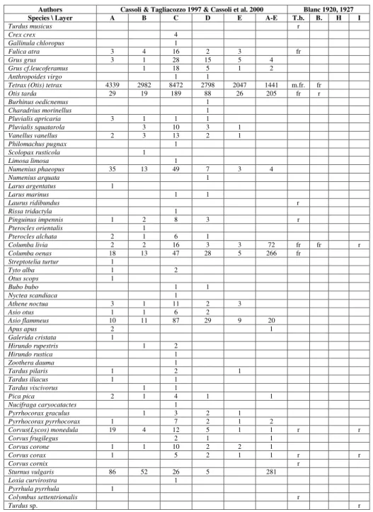
Authors Cassoli & Tagliacozzo 1997 & Cassoli et al. 2000 Blanc 1920, 1927 Species \ Layer A B C D E A-E T.b. B. H I
Turdus musicus r Crex crex 4 Gallinula chloropus 1 Fulica atra 3 4 16 2 3 fr Grus grus 3 1 28 15 5 4 Grus cf.leucoferamus 1 18 5 1 2 Anthropoides virgo 1 1
Tetrax (Otis) tetrax 4339 2982 8472 2798 2047 1441 m.fr. fr
Otis tarda 29 19 189 88 26 205 fr r Burhinus oedicnemus 1 Charadrius morinellus 1 Pluvialis apricaria 3 1 1 1 Pluvialis squatarola 3 10 3 1 Vanellus vanellus 2 3 13 2 1 Philomachus pugnax 1 Scolopax rusticola 1 Limosa limosa 1 Numenius phaeopus 35 13 49 7 3 4 Numenius arquata 1 Larus argentatus 1 Larus marinus 1 1 Laurus ridibundus r Rissa tridactyla 1 Pinguinus impennis 1 2 8 3 r Pterocles orientalis 1 Pterocles alchata 2 1 6 1 Columba livia 2 2 16 3 3 72 fr fr r Columba oenas 18 13 47 28 5 266 fr Streptotelia turtur 1 Tyto alba 1 2 Otus scops 1 Bubo bubo 1 1 Nyctea scandiaca 1 Athene noctua 3 1 11 2 3 Asio otus 1 1 6 2 Asio flammeus 10 11 87 29 9 20 Apus apus 2 1 Galerida cristata 1 Hirundo rupestris 1 2 Hirundo rustica 1 Zoothera dauma 1 Tardus pilaris 1 2 1 Tardus iliacus 1 1 Tardus viscivorus 1 1 Pica pica 2 1 4 1 1 Nucifraga caryocatactes 1 Pyrrhocorax graculus 1 3 2 1 Pyrrhocorax pyrrhocorax 1 7 2 1 2 Corvus(Lycos) monedula 19 4 12 5 1 1 r r Corvus frugilegus 2 1 1 Corvus corone 1 1 10 2 2 1 Corvus corax 1 5 2 1 1 r r Corvus cornix r Sturnus vulgaris 86 52 26 5 281 Loxia curvirostra 1 Pyrrhula pyrrhula 1 Colymbus settentrionalis r Turdus sp. r
Tab. 4b - Birds from Grotta Roma-nelli (Modified from Blanc 1920, 1927; Cassoli & Ta-gliacozzo 1997; Cassoli et al. 2000). Cassoli & Tagliacozzo (1997) & Cassoli et al. (2000) reported the number of fos-sil remains of each species coming from different le-vels. Blanc (1920) indicated the relative frequency of each species on a scale from 1 to 4 (m.r., r., fr., m.fr.) for each level.
of the Romanelli canid, (such as slender muzzle with a short palatal area, tooth crowding, rounded neurocranium with a gently sloping forehead and low sagittal and nuchal crests, and reduced tympan-ic bullae) the biochronologtympan-ical signiftympan-icance of such features needs to be considered with caution and using a multidisciplinary approach. Gliozzi et al. (1997) choose the first occurrence in Italy of Canis lupus, together with those of Megaloceros giganteus
and Ursus spelaeus, as the bio-events that defined the
beginning of the Aurelian Mammal Age during the late Middle Pleistocene. Therefore, an attribution to a medium-sized Mediterranean wolf is in accord-ance with a late Middle to Late Pleistocene age. In addition, the fossils from the “terre rosse” need to be investigated in detail to evaluate their biochron-ological significance. In general, the fossil remains recovered in the cave have never been re-studied in depth by later authors, and a revision and update of the faunal list is currently under way. The rhino remains from the “terre rosse” (layer G) previously referred to Rhinoceros merckii (=Stephanorhinus kirch-bergensis) by Stasi & Regalìa (1904) and Blanc (1920,
1928), have recently been revised by Pandolfi & et al. (2017) who referred them to the Late Pleistocene narrow nosed rhino Stephanorhinus hem-itoechus. Moreover, Pandolfi & Tagliacozzo (2013)
carried out a review of the material from layer I, and referred a single isolated proximal epiphysis of a third metacarpal to Coelodonta antiquitatis. In Italy,
the distribution of this species is limited to part of the Late Pleistocene, and taxonomic attribution based on fragmentary postcranial remains has to be considered with caution.
The study of the canid skulls and preliminary attributions of the large mammals from the lower level suggests a late Middle to Late Pleistocene age, therefore a combination of palaeontological data and radiometric and stratigraphic analyses is need-ed to clarify its age.
The archaeological data
Stasi and Regalia (1904) discovered human bones buried in the “terre brune”. They described several remains, such as one adult and two younger complete skeletons and some mandibles, now stored in the Anthropology Museum of the University Federico II (Naples). During more recent excava-tions, other remains were discovered and studied by Fabbri (1987) and stored in the IsIPU collection.
During the excavations carried out by Blanc (1920, 1928) and Cardini and Biddittu (1964-67), many lithic and bone artefacts were recovered, demonstrating human occupation in different strati-graphic layers (Blanc 1928; Laplace 1966; Taschini & Bietti 1972; Palma di Cesnola et al. 1983). In the
“terre brune”, 111 artefacts of portable art were re-covered (Graziosi 1932-1933; Acanfora 1967). The engraved stones show some zoomorphic motifs, mostly incomplete; linear motifs predominate, and evidence a strong homogeneity in graphic style and source of inspiration (Frediani & Martini 2003).
The lithic industry from the upper complex (A-E) is very abundant, with about 10.000 tools re-covered. Layer C is particularly rich, with 5800 ar-tefacts, whereas layer E has yielded only 200 tools. The tools include endscrapers and burins, as well as many backed truncated tools. According to Bietti (2003), the industry of the upper complex (A-E) shows the peculiarity of an accurately retouched point on a blade, bladelet, or flake, sometimes double and, accordingly, bipointed, and of some geometric microliths (rare rectangles and frequent circular segments produced by micro burin tech-nique). The features of the lithic industry yielded by the terre brune could be assigned to the final Epigravettian, the so-called Romanellian (Mussi 2002; Bietti 2003). The bone industry was recovered only from the levels A-E, with a total number of 56 tools, of which 27 came from layer C (Molari 2003). Few lithic tools and no bone artefacts were
Authors Cassoli et al. 2000 Blanc 1920
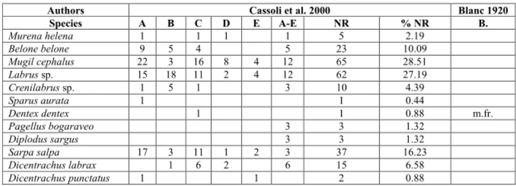
Species A B C D E A-E NR % NR B. Murena helena 1 1 1 1 5 2.19 Belone belone 9 5 4 5 23 10.09 Mugil cephalus 22 3 16 8 4 12 65 28.51 Labrus sp. 15 18 11 2 4 12 62 27.19 Crenilabrus sp. 1 5 1 3 10 4.39 Sparus aurata 1 1 0.44 Dentex dentex 1 1 0.88 m.fr. Pagellus bogaraveo 3 3 1.32 Diplodus sargus 3 3 1.32 Sarpa salpa 17 3 11 1 2 3 37 16.23 Dicentrachus labrax 1 6 2 6 15 6.58 Dicentrachus punctatus 1 1 2 0.88
Tab. 5 - Fishes from the “terre bru-ne” layers of Grotta Roma-nelli (Modified from Blanc 1920; Cassoli et al. 2000). Cassoli et al. (2000) reported the number of fossil remains of each species coming from different levels. Blanc (1920) indicated the relative fre-quency of each species on a scale from 1 to 4 (m.r., r., fr., m.fr.) for each level.
recovered from the lower complex (Blanc 1920, 1928; Piperno 1974; Palma di Cesnola 2003). The lithic industry of layer G has been referred to the Mousterian and is characterised by 1105 limestone tools and a single flint tool (Piperno 1974). This lat-ter author highlighted the peculiarity of these lithic artefacts and he also noticed the lack of Levallois points and the lack of shell tools on Callista chione.
Blanc (1928) suggested that the stalagmitic layer H was archaeologically sterile, although he identified fragments of charred bones in the thin coal beds.
Remains of fireplaces were discovered in layers I-K (Blanc 1928; Piperno 1974), associated with some limestone, flint and quartzite tools, and a pebble of ochre, which are evidence of the first occupation of the cave by humans.
Rock art
Evidence of human occupation of the site also comes from the cave art: engravings on the walls and vault (Blanc 1940; Frediani & Martini 2003). The cave walls are engraved, but probably were painted too, as a slab with red figures found in the archaeological layers suggests (Blanc 1938).
The figurative palimpsest of GR, according to the literature includes: two bovids, a deer, fem-inine silhouettes, geometric figures, lines and a
supposed “Gönnersdorf-style” feminine silhouette (Ciccarese 2000; Graziosi 1973; Mussi et al. 2008). For about half a century, GR was the only Italian site with cave art referable to the upper Palaeolithic and it is still considered unique for its huge rock art heritage.
The chronological framework
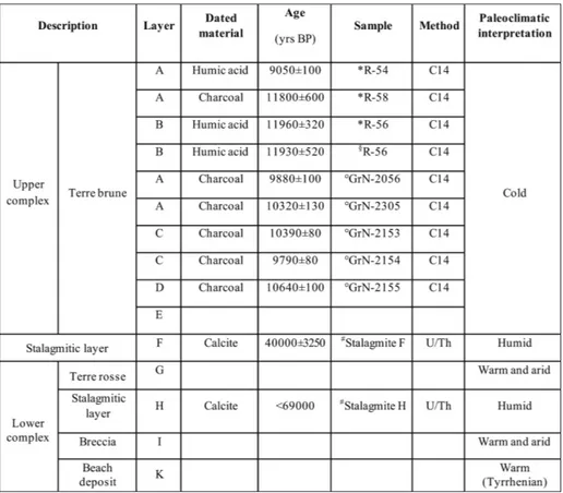
The palaeoclimatic interpretation inferred from the vertebrate assemblage, and the relative chronology, were considered of such a great impor-tance that it was decided to carry out C14 dating on layers A-E. For this reason, during the 1954 ex-ploration Blanc and Cardini collected three samples, from layers A, B and E respectively (Fig. 5), that were dated in the laboratory of the University La Sapienza in Rome (Bella et al. 1958; Alessio et al. 1964, 1965). Vogel and Waterbolk (1963) obtained five C14 dates on charcoal from layers A-E (Fig. 5).
Two speleothems from GR were dated by Fornaca-Rinaldi by means of the 230Th/234Th method (Rinaldi 1968a, 1968b; Fornaca-Rinaldi & Radmilli 1968). The first sample is the stalagmitic layer F between the “terre rosse”, con-taining some remains of Mousterian industry (Piperno 1974), and the “terre brune” containing some remains of Upper Palaeolithic industry (Bietti Fig. 5 - List of published ages relative
to Grotta Romanelli (*Ales-sio et al. 1965; §Bella et al.
1958; °Vogel & Waterbolk 1963; #Fornaca-Rinaldi &
Radmilli 1968). The lette-ring of the layers refers to the stratigraphic layers as reported in Fig. 3. The pa-laeoclimatic interpretation reports the considerations inferred from the vertebrate assemblages relative to each layer (Blanc 1920, 1924) and confirmed by the geochemi-cal analyses (Cortesi 1958). Blanc (1920) referred the en-tire sequence, from A to K, to the Late Pleistocene.
2003), with an age of 40 ± 3.2 kyr (Fig. 5). The second sample is erroneously attributed to layer F (Fornaca-Rinaldi 1968b, p. 121). According to the description, it is a stalagmite cementing the breccia on the last Tyrrhenian beach and it therefore repre-sents layer H, and with an apparent age of 69 kyr (no error is associated to this date) (Fig. 5). Later, Mastronuzzi et al. (2007) dated by U/Th methods the algal rim of Tanarea sp. collected at the base of
the notch placed at 9.7m asl just outside GR and considered the result (51.5±2.1 kyr sample RM1, Lab.Id. 6662) not useful.
F
Ield workWith the permission of the Soprintendenza archeologia, belle arti e paesaggio delle province di Brindisi, Lecce e Taranto (former Soprintendenza archeologica), a new excavation campaign was or-ganized during the summer of 2015. Already during the first field surveys, it was evident that the depos-its inside the cave had been extensively removed by the earlier excavations. The first task of the team was to clean all the sections and to differentiate the in-situ deposits from the natural accumulation due to erosion and the reworked material, a remnant of the previous excavations.
The photographic archive of the first exca-vations reveals a sediment infilling the cave from floor to ceiling (Fig. 6a, c) in contrast to today. At present, the remaining infilling sediment is quite re-duced (Fig. 6b, d) by official and, unfortunately, also unofficial excavations.
The first step of the new excavations was to recognise the stratigraphic layers described by Blanc (1920). A simple comparison with old pho-tos showed clearly that the uppermost layers (A and B?) are most likely lost. The lower complex also has been strongly affected by older excavations but the trenches made by Blanc are still visible (Fig. 6d).
The potholes on the basal surface are still vis-ible but devoid of sediments.
The rock art is badly preserved due to several factors affecting it: organics (lichens, both crustose and foliose, algae, fungi and spider nests), which are differently distributed on the cave walls, obstructing the scars of the engravings; physical and chemical weathering, causing erosion and fracturing of the rock surfaces; and anthropic actions (the residuals
of the moulding made in the 1930s, recent paint-ings). The systematic documentation and study of the rock art is among the main objectives of the fieldwork in progress, in order to establish a more precise relationship between the rock art ensemble and the archaeological layers and to update the study of the GR rock art in the light of the most recent Italian and Euro- Mediterranean rock art studies.
t
heG
rottar
omanellI oxymoronThe gathering of all the available data from GR has demonstrated the contradiction existing be-tween the faunal assemblage and the archaeological material (Masini et al. 1990; Sala et al. 1992).
The lower complex has been referred to a warm and arid climatic interval (Fig. 5) on the ba-sis of the vertebrate fauna (Blanc 1920, 1928). It is characterised by the occurrence of large mammals such as P. antiquus and H. amphibius that cannot be
considered biochronological markers, but are dis-tributed from the Middle Pleistocene to the Late Pleistocene. The presence of such large mammals and of a canid that has been compared to C. mos-bachensis, a primitive wolf distributed from the Early
to the Middle Pleistocene, supports the supposed older age of the lower complex (Masini et al. 1990; Sala et al. 1992). However, the canid, despite its pe-culiar set of characters and its relatively reduced size, can be considered as a Mediterranean wolf ref-erable to C. lupus (Sardella et al. 2014), and
consist-ent with a late Middle to Late Pleistocene age. The earliest “true wolves” occurred in Italy in the late Middle Pleistocene, and therefore the canid from the “terre rosse” cannot be considered a biochron-ological marker restricted to the Late Pleistocene. In the SP, Middle Palaeolithic industries were reported from Grotta del Cavallo (Sarti et al. 1998; Sarti et al. 2002), Riparo Marcello Zei (Dantoni & Nardi 1980), Grotta di Capelvenere (Giusti 1979, 1980), Serra Cicora (Spennato 1981) and Grotta dell’Alto (Palma di Cesnola 1967). In particular, the Grotta del Cavallo
Fig. 6 - The infilling deposits of Grotta Romanelli. Southwestern sector: a) in 1920 (Blanc 1920, Tav. 5); b) in 2016 (photo by Gianluca Gandini). Northwestern sector: c) in 1920 (Blanc 1920, Tav. 4); d) in 2016 (photo by Gianluca Gandini). The letters indicate the stratigraphy reported by Blanc (1920).
stratigraphy preserves some Mousterian layers (F-M), with an evolved trend in Mousterian industries from the bottom to the top (Douka & Spinapolice 2012). Layer M, attributed to a Quina Mousterian (Palma di Cesnola 1966a, 1966b), included large tools on limestone, smaller implements in flint and jasper, Mousterian points (Palma di Cesnola 1996b) and shell tools on the marine bivalve C. chione. The
Grotta del Cavallo sequence (F-M) is constrained to between 47.530-43.000 (Romagnoli et al. 2014) and >107.000 (age of the tephra layer found in layer G, Douka & Spinapolice 2012). In addition, Mousterian artefacts from the other Salentine Peninsula sites have been defined as Quina Mousterian, including Mousterian points (Levallois) and shell tools on C. chione. The lithic industry recovered from the “terre
rosse” of GR has been considered archaic due to the presence of artefacts and the lack of shell tools on
C. chione, the lack of Levallois points, and the
exclu-sive use of limestone (Piperno 1974). A stalagmitic layer, layer F, separates this complex from the up-per “terre brune” complex that has been extensively dated by C14 (Fig. 5). These dates constrain the age of the “terre brune” (layers from A to D) to the earliest Holocene, although their lowermost portion (layer E) has never been dated. The “terre brune”, rich in organic matter, represent a cold and humid palaeoenvironment (Blanc 1920, 1928). As a matter of fact, layer E has yielded extremely scarce fossil re-mains and artefacts in comparison to the rest of the “terre brune” (Tabs 1, 2, 5). It is apparent that the abrupt change from eolic/residual sedimentation to calcium carbonate deposition could have been con-trolled either by climate oscillations or local events. The existence of the fossiliferous breccia outside the cave favours the hypothesis that the cave could have been sealed, totally or partially, hindering the entrance of animals and the occupation of humans for a certain amount of time.
The eolian sediments
The sediments of both terre rosse and terre brune have been related to eolian transport (Blanc & Cortesi 1941). The opening of GR faces E and develops in a WNW-ESE direction.
Data from anemometer stations located at Otranto-Palascia and Santa Maria di Leuca (Selicato et al. 2007) clearly show that the prevailing winds affecting the SP are those coming from N, NW and S. This pattern cannot explain the amount of
sedi-ment infilling the cave unless it is assumed that the prevailing wind had a different direction in the past. Previous research on another site along the Adriatic coast of Apulia (Riviera Sud di Manfredonia, De Santis & Caldara 2015) has demonstrated a prev-alence and dominance of NE and E winds during the middle Holocene (up to c. 5.5 ka cal BP) and a change in this trend afterwards.
This change in prevailing wind directions is supposed to be linked to the expansion of the tropi-cal dry Saharan belt, and thus the termination of the African Humid period (De Santis & Caldara 2015). During the Last Glacial Maximum (22±2 ka cal BP), when the eustatic sea level was around 120m lower than at present, the coastal plain in front of GR was supposed to be more than 20 km wide (Cassoli et al. 1979). This huge coastal plain hosted a variety of environments from a lagoon to a wetland, that could have been fringed by sand dunes (Cassoli et al. 1979). In particular, the occurrence of birds such
as Pterocles archata (pin-tailed sandgrouse) indicates a
terrestrial environment ranging from open semi-ar-id to an occasionally dried-out mud flat. Thus, the source of sediments in GR could be the flat plain overlooking the cave that, subject to sea level rise, progressively disappeared. An additional source could have been the eolian dust coming from N Africa (Moresi & Mongelli 1988), entering the cave blown by E and NE winds. At about 6 ka BP, the sea level in the investigated area was about -7 m below the modern sea level (Lambeck et al. 2004) and the coastal plain must have greatly diminished in size. In central Mediterranean lakes, it is well known that the percentage of eolian sediment content drastical-ly decreased at ca 6000 – 5000 cal yrs BP (Narcisi 2000) confirming the change in wind regime evi-denced by De Santis and Caldara (2015). This time frame is considered as a transitional phase between a cyclogenesis to the E-SE of the Italian peninsula and the more recent cyclogenesis to the W-NW (De Santis & Caldara 2015).
c
onclusIonsThe new project about GR has provided the impetus to bring together the corpus of literature on the site that spans many decades: geochemical, chronological, palaeontological, anthropological and archaeological. The opening of the cave to new
studies requires not only a revision of all the exist-ing literature but also an investigation into the exact provenance of the materials reported from previ-ous studies.
The basis for the new field excavations has been the creation of a database with all the informa-tion relative to the content of the cave. Moreover, the first field work season (2015) has established the following points:
The extent of the deposits inside the cave is now extremely reduced compared to the situation depicted in the pictures provided by Blanc (1920).
Most of the layers described by Blanc (1920), Lazzari (1955) and Piperno (1974) are still preserved in the cave, although their thickness and areal distri-bution is variable.
Preliminary analysis of the fauna and the lith-ic tools from the lower complex suggests a possible late Middle to early Late Pleistocene age.
The location of GR at the south-eastern tip of Italy implies that relatively ice-free condi-tions persisted even during glacials and thus, as a terrestrial archive, its sediments can provide a con-tinuous record of environmental change through a full range of climatic boundary conditions. The observations and analyses begun during the 2015 survey strongly suggest that a complex scenario can be constructed for the origin of the cave, the infill-ing deposits and their evolution. Considerinfill-ing that many sites along the SP consist of karstic or bone breccia deposits with no age constraints and that the chronology of GR has always been considered a reference, redefinition of the stratigraphic scheme proposed by Blanc is a priority. The extraordinary richness of the palaeontological and archaeological evidence from GR is for the first time presented in a critical review that also considers the questions arising from conflicting data.
Grotta Romanelli is a key site for understand-ing of the Mediterranean Middle-Late Pleistocene regional context and establishing the framework of human presence in the Mediterranean region.
Acknowledgements: The authors are indebted to the
Soprintendenza archeologia, belle arti e paesaggio delle province di Brindisi, Lecce e Taranto for the triennial excavation permission 2015-2017 (resp. R. Sardella) (Maria Piccarreta, Salvatore Bianco, Assunta Cocchiaro, Luigi La Rocca, Laura Masiello, Italo Muntoni). “Progetto Grandi Scavi” of Sapienza, University of Rome 2016, 2017 (resp. Raffaele Sardella) is acknowledged for funding. We wish to thank Medica Assunta Orlando (Museo Civico di Paleontologia e Paletnologia, Maglie), Antonio Tagliacozzo and Luca Bondioli
(Museo Nazionale Preistorico ed Etnografico L. Pigorini, Roma), Luciano Bruni, Stefano Grimaldi and Simona Pianese Longo (IsIPU) for their assistance in locating the archaeological and palaeontolog-ical material from GR and the opportunity to study it. Many col-leagues helped during the 2015 fieldwork: Luca Bellucci, Andrea Billi, Giovanni Gaglianone and Antonella Sciancalepore. Ninì Ciccarese, Toto De Santis, Don Piero Frisullo, Alfonso Capraro and Michele Rizzo for their continuous and precious logistic support. We thank Fabio Bona, Mauro Coltorti, Jacopo Conti, Gianluca Gandini, Biagio Giaccio, Carlo Peretto, Marina Pinna, Simona Rosselli, Enza Spinapolice, Flavia Strani and Gruppo Speleologico Salentino for their useful suggestions and help. Finally, we wish to thank Lars Werdelin and two anonymous referees for comments and sugges-tions that greatly improved the manuscript.
RefeRences
Acanfora M.O. (1967) - Figurazioni inedite della Grotta Romanelli. Presentazione preliminare. Bull. Paletnol. It.,
76: 7-68.
Alessio M., Bella F. & Cortesi C. (1964) - University of Rome Carbon-14 dates II. Radiocarbon, 6: 77-90.
Alessio M., Bella F., Bachecchi F. & Cortesi C. (1965) - University of Rome Carbon-14 dates III. Radiocarbon, 7:
213-222.
Bella F., Blanc A.C., Blanc G.A. & Cortesi C. (1958) - Una prima datazione con il carbonio 14 della formazione pleistocenica di Grotta Romanelli (Terra d’Otranto).
Quaternaria, 5: 87-94.
Bellanca A., Hauser S., Neri R. & Palombo B. (1996) - Mineralogy and geochemistry of Terra Rossa soils, western Sicily: insights into heavy metal fractionation and mobility. Sci. Total Env., 193: 57-67.
Bietti A. (2003) - Caratteristiche tecnico-tipologiche del “Romanelliano” di Grotta Romanelli (Castro Marina, Lecce). In: Fabri P., Ingravallo E. & Mangia A. (Eds) - Grotta Romanelli nel centenario della sua scoperta (1900-2000): 91-111, Congedo Editore.
Blanc G.A. (1920) - Grotta Romanelli I. Stratigrafia dei deposi-ti e natura e origine di essi. Archivio per l’Antropologia e la Etnologia, 50: 1-39.
Blanc G.A. (1927) - Sulla presenza di Alca impennis Linn.
nel-la formazione superiore di Grotta Romanelli in Terra d’Otranto. Archivio per l’Antropologia e la Etnologia, 58:
155-186.
Blanc G.A. (1928) - Grotta Romanelli II. Dati ecologici e palet-nologici. Archivio per l’Antropologia e la Etnologia, 58: 1-49.
Blanc G.A. (1938) - Interpretazione geochimica delle forma-zioni quaternarie di Grotta Romanelli (Terre d’Otran-to). II – I complessi colloidali. Atti della Reale accademia nazionale dei Lincei. Rendiconti della Classe di scienze fisiche, matematiche e naturali, 28: 75-84.
Blanc A.C. (1938) - Dipinto schematico rinvenuto nel Paleolitico superiore della Grotta Romanelli in Terra d’Otranto. Riv. Antropol., 32: 3-17.
Blanc A.C. (1940) - Nuove manifestazioni d’arte paleolitica su-periore nella Grotta Romanelli in Terra d’Otranto. Reale Accademia d’Italia, Rendiconti della Classe di Scienze fisiche,
matematiche e naturali, 1: 1-11.
Blanc A.C., Cardini L. & Cassoli P. (1962) - Campagna di scavo nella Grotta Romanelli (Lecce). Quaternaria 5: 305.
Blanc G.A & Cortesi C. (1941) - Interpretazione geochimica delle formazioni quaternarie di Grotta Romanelli (Terre d’Otranto). III – Le sostanze umiche fossili. Atti della Reale accademia nazionale dei Lincei. Rendiconti della Classe di scienze fisiche, matematiche e naturali, 7: 33-55.
Bosellini A. & Parente M. (1994) - The Apulia Platform mar-gin in the Salento Peninsula (southern Italy). Giorn. Geol.,
56(2): 167-177.
Bosellini F.R. & Russo A. (1994) - Coral facies across an Oligocene fringing reef (Salento Peninsula, Southern Italy). Courier Forschung. Senckenberg, 172: 261-264.
Bosellini A., Bosellini F.R., Colalongo M.L., Parente M., Russo A. & Vescogni A. (1999) - Stratigraphic architecture of the Salento coast from Capo d’ Otranto to Santa Maria di Leuca (Apulia, southern Italy). Riv. It. Paleontol. Strat.,
105(3): 397-416.
Bossio A., Mazzei R., Monteforti B. & Salvatorini G. (2005) - Stratigrafia del Neogene e Quaternario del Salento sud-orientale (con rilevamento geologico alla scala 1:25.000). Geologica Romana, 38: 31-60.
Botti U. (1874) - Sulla scoperta di ossa fossili in Terra d’Otran-to. Bollettino del Regio Comitato Geologico, 1: 7-8.
Cardini L. (1963) - Presentazione delle industrie musteriane su calcare dei livelli a terre rossa di Grotta Romanelli.
Atti dell’VIII riunione dell’istituto di Preistoria e Protostoria, Trieste, 43 pp.
Cardini L. & Biddittu I. (1967) - Attività scientifica dell’Istituto Italiano di Paleontologia Umana della sua fondazione.
Quaternaria, 9: 385-408.
Cassoli P.F. (1992) - Avifauna del Pleistocene Superiore delle Arene Candide, Praia e Grotta Romanelli (Italia).
Quaternaria Nova, 2: 239-246.
Cassoli P.F. & Tagliacozzo A. (1997) - Butchering and Cooking of Birds in the Palaeolithic Site of Grotta Romanelli (Italy). Intern. J. Osteoarcheol., 7: 303-320.
Cassoli P.F., Segre A.G. & Segre E. (1979) - Evolution mor-phologique et écologique de la côte de Castro (Pouilles) dans le Pléistocène final. Colloques internationaux C.N.R.S.,
219: 325-332.
Cassoli P.F., Gala M. & Tagliacozzo A. (2003) - La caccia e l’uti-lizzo alimentare degli uccelli a grotta Romanelli durante le fasi finale del Pleistocene. In: Fabri P., Ingravallo E. & Mangia A. (Eds) - Grotta Romanelli nel centenario della sua scoperta (1900-2000): 91-111, Congedo Editore. Ciccarese G. (2000) - I graffiti di grotta Romanelli. In: Spelaion,
2000: 146-147. Uniongrafica Corcelli Editrice, Bari. Cortesi C. (1958) - Studio sedimentologico e geochimico
comparativo fra la “terra rossa” pleistocenica di Grotta Romanelli (Terra d’Otranto) e la locale “terra rossa” at-tuale. Periodico di Mineralogia, 27: 353-405.
Cuerda J. (1987) - Moluscos Marinos y Salobres del Pleistoceno Balear. Caja de Baleares ‘Sa Nostra’, Mallorca, 421 pp.
Dantoni G. & Nardi N. (1980) - La Grotta riparo “Marcello
Zei” (Santa Caterina, Nardò). Studi per l’Ecologia del
Quaternario, 2: 97-119.
De Santis V. & Caldara M. (2015) - The 5.5-4.5 kyr climatic transition as recorded by the sedimentation pattern of coastal deposits of the Apulia region, southern Italy. The Holocene, 25(8): 1313-1329.
Di Stefano G., Petronio C., Sardella R., Savelloni V. & Squazzini E. (1992) - Nuove segnalazioni di brecce ossifere nella costa fra Castro Marina e Otranto (Lecce). Il Quaternario,
5(1): 3-10.
Di Stefano G., Petronio C. & Sardella R. (1994) - Il signifi-cato biocronologico e paleoecologico di alcuni taxa di mammiferi del Plio-Pleistocene dell’Italia centrale. Studi Geologici Camerti, 459-467.
Doglioni C., Mongelli F. & Pieri P. (1994) - The Puglia uplift (SE-Italy): an anomaly in the foreland of the Apenninic subduction due to buckling of a thick continental lito-sphere. Tectonics, 13(5): 1309-1321.
Douka K. & Spinapolice E.E. (2012) - Neanderthal Shell Tool Production: Evidence from Middle Palaeolithic Italy and Greece. J. World Prehis.,25: 45-79.
Fabbri P.F. (1987) - Restes humains retrouvés dans la grotte Romanelli (Lecce, Italie): étude anthropologique. Bull. mém Soc. anthropol. Paris 4(4): 219-247.
Fabri P. (2003) - Il popolamento nel Paleolitico Superiore. In: Fabri P., Ingravallo E. & Mangia A. (Eds) - Grotta Romanelli nel centenario della sua scoperta (1900-2000): 81-90, Congedo Editore.
Fornaca-Rinaldi G. (1968a) - Il metodo 230Th/238U per la datazione di stalattiti e stalagmite. Boll. Geofis. Teor. Appl.,
10: 3-14.
Fornaca-Rinaldi G. (1968b) - 230Th/234Th dating of cave concretions. Earth Plan. Sci. Lett., 5: 120-122.
Fornaca-Rinaldi G. & Radmilli A.M. (1968) - Datazione con il metodo 230Th/238U di stalagmiti contenute in depositi musteriani. Atti Soc. Toscana Sci. Nat. 75(1): 639-646.
Frediani A. & Martini F. (2003) - L’arte paleolitica di Grotta Romanelli. In: Fabri P., Ingravallo E. & Mangia A. (Eds) - Grotta Romanelli nel centenario della sua scoperta (1900-2000): 69-80, Congedo Editore.
Funiciello R., Montone P., Parotto M., Salvini F. & Tozzi M. (1991) - Geodynamic evolution of an intra-orogenic foreland: the Apulia case history (Italy). Boll. Soc. Geol.
110: 419-425.
Gala M. & Tagliacozzo A. (2010) - The avifauna from Late Glacial archaeological sites in Italy: a tentative synthesis. In: Prummel W., Zeiler J.T. & Brinkhuizen D.C. (Eds) - Birds in Archaeology. Proceedings of the 6h Meeting of the ICAZ. Bird Working Group in Groningen (23.8 - 27.8.2008). Groningen Archaeol. Studies, 10: 205-218.
Garavelli C.L., Quagliarella Asciano F. & Vurro F. (1974) - Mellite di Grotta Romanelli (Otranto). Periodico di Mineralogia, 43: 39-49.
Giusti M. (1979) - La Grotta di Capelvenere a S. Caterina– Nardò (Campagna di scavo 1974). Studi Ecol. Quaternario,
1: 19-40.
Giusti M. (1980) - La Grotta di Capelvenere a S. Caterina– Nardò (Campagna di scavo 1975). Studi Ecol. Quaternario,
2: 77-85.