Il rilievo integrato come base per la pianificazione urbana
The integrated survey as the base for urban planning
Chiara Vernizzi, Department of Civil and Environmental Engineering and Architecture, University of Parma Andrea Zerbi, Department of Civil and Environmental Engineering and Architecture, University of Parma
Abstract
A seguito del sisma del 6 aprile 2009 che colpì pesantemente l’Abruzzo, nel 2011 il Comune di Navelli ha stipulato una convenzione con il DICATeA dell’Università degli Studi di Parma avente come obiettivo lo svolgimento di attività tecniche e scientifiche relative allo studio, all’analisi e al progetto per la ricostruzione dei centri storici del capoluogo e della frazione di Civitaretenga. Il DICATeA ha affrontato il tema basandosi su un approccio metodologico fortemente interdisciplinare, mirato alla costituzione di un archivio informativo facilmente consultabile, aggiornabile e interfacciabile con altri archivi esistenti. Una siffatta modalità di approccio al tema dona un ruolo fondamentale al rilievo, inteso come strumento critico di conoscenza, attraverso il quale il costruito rivela le molteplici informazioni di cui è portatore.
Due to the earthquake that on April 2009 severely hit the Abruzzo region, in 2011 the Municipality of Navelli signed an agreement with the DICATeA (University of Parma) to develop scientific and technical activities to implement a project for the reconstruction of the old town centers of Navelli and Civitaretenga. DICATeA used an original and highly interdisciplinary methodological approach, aiming at the development of an information system, resulting easily accessible, updatable and interfaceable with other existing archives. This approach allows for a more fundamental survey, featured as a critical instrument of knowledge and as a way through which the built environment reveals the multiple information it contains.
Keywords: Integrated urban survey, Information system, Reconstruction plan.
Introduction
On April the 6th, 2009 a strong earthquake measuring 5.9 on the Richter Scale shook the Abruzzo and in particular L’Aquila and most of his province, causing severe damage throughout the territory. As a result of this tragic event, the Italian central government implemented a series of policies for reconstruction activities, transferring to the municipalities of L’Aquila crater both the tasks of arranging the planning tools for the area and of defining strategic guidelines to ensure socio-economic recovery, settlements retraining and harmonious reconstruction of the urban building.
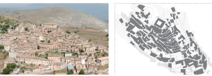
The town of Navelli (AQ), is located among the 57 municipalities of L’Aquila, Teramo and Pescara provinces affected by the earthquake. This town rises about 700 meters above sea level, on the south-west side of Mount San Nicola. The Navelli’s old town center (Figure 1), founded during the Middle Ages, still shows clearly the different eras of the urban system. The area of the original settlements, characterized by buildings set on roads that run parallel to the level curves, most of which exhibit a very bad preservation status, shows many buildings now reduced to ruins. The system of the blocks is typical of the medieval structure, which is characterized by narrow streets and buildings constructed according to the typical shape of the “gothic lot”, that here is varied due to the unflatness of the territory. Instead, the part of the old town center located outside the path of the medieval walls is less affected by road leaning to level curves, due to both the lower slope of the terrain, and to the more structured plan of the buildings, some of which are true renaissance palaces. In this area the blocks are more compact, morphologically very articulate and quite varied in size. The need to adapt blocks and buildings to the shape and slope of the land resulted in significant differences between the east and the west areas of the town. These few considerations highlight the complexity of the historical context and built environment that urban planners face. For this reason in 2011, the Municipality of Navelli signed an agreement with the Department of Civil and Environmental Engineering and Architecture (DICATeA) – University of Parma, with the scope of carrying out technical and scientific activities in support of the R.U.P. to study, perform analysis
and implement a project for the reconstruction of the old town centers of Navelli and of his fraction Civitaretenga. The ultimate aim was to bring to completion the training and the approval of the Reconstruction Plan for the two areas bounded from the Municipality of Navelli. This paper describes the procedures used for this purpose.
Methodological framework
The drafting of a Reconstruction Plan and the definition of implementation criteria and methods require a wide range of preliminary investigations that lead to the development of all the material supporting the real planning operations. In the specific case, the existing documentation was limited to the cadastral plans, the current planning instruments and the cards of damage made by the Civil Protection after the earthquake. The Department of Civil and Environmental Engineering and Architecture, represented by Prof. Paolo Ventura, key expert of the Convention, and by a team of experts, used an original and highly interdisciplinary methodological approach, aiming at the development of an adequate information system, resulting easily accessible, updatable and interfaceable with other existing archives. This approach allows for a more fundamental survey, here intended in the broadest sense of the term. “Representing a city or part of it, has always been something better and different with respect to the sum of the images of the buildings configuring its structure” (Boido, Coppo, 2010). The urban survey, in fact, analyzes, synthesizes and communicates different type of data then the architectural survey of each single building. It is featured as a critical instrument of knowledge and as a way through which the built environment reveals the multiple information it contains. For this reason, the urban survey cannot be restricted only to the geometrical and dimensional survey of the built environment itself, but it must also highlight the complex relationships among the constructive, structural, distributional and figurative aspects. An important step in the survey aimed at urban recovery interventions is the generation of strong linkages between surveys realized at an architectural scale and survey performed at the city scale. The concept of survey related to a complex urban context must be interpreted as an open cognitive process and, as such, it must be combined with multiple disciplinary skills aimed at understanding the consistency of the object under investigation. The ability of the “surveyor” is therefore to develop each time a methodology of investigation that contemplates the use of different systems of surveying, cataloging and data processing in order to determine the formal and structural invariants in the image identification of the specific urban center under study. Assuming these concepts as survey basis, the specific operations can be implemented according to the common practice already tested and reviewed in accordance with the specific contingent goals. In this case the whole work was carried out in several phases characterized by collaboration between the different expertise areas involved. First of all, an exhaustive study of the state of the places was carried out performing several survey campaigns to update the base maps, the construction of geometrical models of the areas under study and the identification of architectural and environmental elements of greater values. Once the data were collected and restituted it was possible to prepare the basic cartography on which a GIS was set. An important photographic database was also created and a study of the settlement system was carried out playing big attention to the survey of the typological aspects, the historic building techniques and the main technological solutions adopted. Additional surveys were performed to verify the static and maintenance conditions of buildings, as well as to assess their historical and architectural value. Finally, all the material produced, inserted into the information system, allowed to draw up proposals for the Reconstruction Plan.
From topographic to direct survey
Any operation of planning obviously cannot abstract from a faithful and updated cartographic representation of the status quo. Therefore, the surveyors team of the Department of Civil and Environmental Engineering and Architecture proceeded to realize a product aimed at showing the peculiarity of the urban area, to provide the necessary documentation to the planners. The availability of an updated and intrinsically three-dimensional survey, combined with the presence of photographic documentation from the ground and from the air, allowed in fact the creation of products with richer information content than the existing cartographic material. The conduct of
survey operations was strongly influenced by the characteristics of urban settlements. The ground survey was organized to constitute, as far as possible, a network of closed polygonal, connected together and articulated to enclose the blocks. To improve the stability of the network, as well as for the georeferencing of the whole survey, it was established a network of GPS points which could directly serve as station points. A photogrammetric restitution, made possible by the execution of a flight above the investigated areas, was performed for the completion of the survey operations in areas not directly accessible. Beside the GPS points, also some topographic points were used as ground support for the photogrammetric block adjustment of Navelli and Civitaretenga.
The topographic survey was carried out creating plano-altimetric polygonals and measuring, from each station, the points to define the trend of the masonry walls of the buildings and the reference points to which anchor the direct survey of stairs, retaining walls, dividing walls, fences, as well as the covers of manholes. In Navelli were positioned about 150 stations measuring more than 4000 points. In Civitaretenga were measured 1500 points from 41 stations. The aerial photographs were acquired using a high-resolution digital camera with calibrated 35 mm lens. The images, due to acquisition condition (manual shooting from the cockpit of a small tourism helicopter) are not pseudo-nadiral as in ordinary photogrammetry, but they are inclined between 30 and 40 degrees with respect to the local vertical. For this reason, parallel strips with very small spacing and redundant number were taken to allow a proper restitution of areas otherwise inaccessible. On the other hand, oblique acquisition geometry allowed to take pictures of most of the facades of the buildings that, otherwise, would have remained occluded from the roofs in a nadiral flight. The photogrammetric survey allowed, among other things, to obtain ortophoto from which it was possible to determine the geometry of the structures that, for reasons of inaccessibility or for the presence of risks for the safety of the surveyors, were not measurable otherwise. Simultaneously with the execution of topographic and photogrammetric surveys an accurate direct survey of what is not measured by using the above methods, was performed. The metric survey of the actual state of Navelli and Civitaretenga was conducted to return the data in 1:500 scale, which is considered the most appropriate to capture all the different specific aspects of the two urban centers. For this reason all those elements of discontinuity (such as stairs, walls, curbs, ramps, etc.) that especially characterize the medieval area of Navelli, were accurately measured. All the different survey techniques used, were incorporated in order to achieve the implementation of plans becoming the basis of the information system and therefore of all the subsequent studies and analysis. After the completion of the measurement operations the computer data restitution was performed; this led to the realization of a three-dimensional digital model and a graphical model having a level of detail sufficient for 1:500 scale. In order to develop drawings able to make completely understandable the morphological complexity of the two settlements, the plans of the connection of the buildings with the ground (Figure 2) were created using a single abstract projection plane and representing the private and public spaces regardless of the elevation of the road system (and consequently of the built environment). The logic behind this type of representation (not conventional as unresponsive to a classical plan realized at a well defined height) was to make understandable the articulation of road links and connections, which are a direct consequence of the particular morphology of the territory that especially characterizes the center of Navelli. The planimetric representation of the connection of the buildings with the ground was completed by the virtual projection of all the elements that are not visible, but that identify the architectural-constructive system (such as counter-arches, vaulted passages and all the other more minute elements). The description of these elements is in fact essential for a comprehensive understanding of the particular configuration of the town. In addition to these, the plans of the roofs were also constructed (Figure 3). Finally, the photogrammetric data collected during the flight allowed the three-dimensional design of the roofs and the main elements that were not accessible from the ground. These data, integrated with topographic measurements of the most significant points of all the buildings that constitute the bounded areas of the historical centers of Navelli and Civitaretenga and together with the spot height map, permitted the reconstruction of digital 3D models of the two settlements, which are essential for an immediate reading of the building volumes (Figure 4). The plans of the connection of buildings with the ground, together with the roof plans and the three-dimensional models, were then used as the basis to set the GIS information model that represent the real support of planning operations.
The building census
In order to obtain a thorough knowledge of every single building that forms the settlements of Navelli and Civitaretenga a census of each identified volumetric unit was carried out, without considering any subdivisions relating to land ownership. This building census was conducted by collecting many different data in specially dedicated data sheet (Figure 5), all aimed at the most comprehensive knowledge of the characters of the buildings. The first part of each card contains, in addition to the data needed for the unique identification of the building (such as location, address, street number and cadastral data), two different levels of classification map, in scales 1:2000 and 1:1000, where the points from which the pictures of the building were taken are also indicated. These pictures are then collected in the second part of the sheet. The third part contains the data relating to the different levels of analysis conducted on site on the building, such as the simple indications of consistency expressed by number and type of floors (such as basement area, ground floor, mezzanine, etc.). In this part of the card some graphic conventions are also used in order to make immediately clear the relationship between the building and the public space in front of it and the building type; this was defined according to a series of specific categories derived from the literature on the typical settlements of the historical context of L’Aquila, such as the building serial units that run parallel to the level curves, the house “at profferlo”, the arc house, the tower house and others. The building was also analyzed in its relationship with the context, highlighting if it is isolated, in the corner or at the end of a block or, yet, if it is connected with other buildings on one, two or three sides. Even a brief functional analysis was conducted identifying the principal functions at the different floors of the building. The final part of the card is then dedicated to the constructive and decorative features of the building itself.
The analysis of building technologies and the verifications of static conditions
In addition to the operations of metric survey, further investigations were carried out by experts in the fields of Technology, Structural Engineering and Restoration of the Department of Civil and Environmental Engineering and Architecture, regarding the prevailing constructive technologies and the static conditions of the buildings after the earthquake.
Knowledge of pre-modern construction technology is in fact necessary wherever phenomena of permanence and repetition of construction processes occur. In this inquiry the typological analysis was considered essential to improve the understanding of the constructive language within the functional and morphological structure. This analysis, implemented by identifying the interrelationship between the different technological, spatial and formal components of the building and the urban fabric to which it belongs, allowed the identification of both the typological invariants and the more radical “structural” transformations which led to new building types. It is properly the analysis of typological transformations that allowed the understanding of every single building in its current condition and the preparation of the subsequent proposal of urban requalification. Without giving much details on the investigations, which is out of the scope of this paper, it is essential to clarify that the knowledge of the main technological solutions used to make the constructive apparatus, were obtained through the decomposition of the building organisms in its components such as vertical closing elements (walls, doorways and windows, connections with the ground), horizontal closing elements (vaults, floors, roofs) and elements for vertical communications (stairs). The knowledge of the prevailing construction characters of the buildings led to the definition of “limits of Conservation” or “degree of transformability”. These must be related to the studies of the occupancy state of buildings, carried out by groups of Restoration and Structural Engineering which integrated and processed the data coming from the Municipality of Navelli and the Civil Protection. At the end of the research, it was developed a synthetic manual of intervention that collects, for each technological unit, a series of adequate actions, congruent with the transformability degree of the building and aimed at restoring the lost quality and at the possible improvement.
From the information system to the Reconstruction Plan
An information system, based on the new survey realized by the Department of Civil and Environmental Engineering and Architecture, was structured to collect and systematize the large amount of gathered
data. In summary, the information system was founded on cataloguing the information taking as a basis the following entities: the buildings and the adjacent areas; the streets; the aggregates, i.e. sets of buildings and adjacent areas subjected to coordinated intervention of reconstruction and consolidation; the fields, identified by perimeters, including buildings and related areas and streets, i.e. urban sections subjected of unified project; the fields of public space, i.e. portions of public spaces, buildings, their adjacent areas and streets. The following information were recorded for each entity: geometric data and photographic images based on the direct analysis of the working group of survey; static data based on the information deposited by the Civil Protection in the damage sheet and later verified; normative indications of planning based on on-site inspections, direct investigations and conclusive analysis. The purpose of this paper is not to describe in detail the GIS system, since that would require too much space; on the contrary it is fundamental to emphasize the fact that the information system constituted the essential tool for the preparation of the Reconstruction Plan: from the interventions specification to the indications of operational guidelines for the implementation of the plan, from the debris disposal plan to the guidelines for the preliminary assessment of economic-financial and technical-administrative feasibility.
Conclusions
To fully understand the environmental value of an architecture or a settlement depending on the geological conformation of the subsoil, it may be necessary to extend the concept of monument to the contour of the built and the empty spaces located between buildings. The protection of the environmental value conceived as a non-renewable resource, must be therefore compared to the values of total “form” of the historical built environment and of its link with the natural environment, through the identification of morphological characteristics and typological values. In this sense an integrated project of recovery of streets, squares, open spaces and green spaces contribute significantly to the preservation of buildings, also through the respect of the values of material culture that they express. It is therefore evident that only through a careful critical reading of the survey aimed at recovery interventions it is possible to begin outlining the guiding principles for proper redevelopment of an historical and consolidated urban context. Between restoration project and survey results, mutual relations need to be created. In fact, even if the type of survey operations is proportionate to the aim of the project, very often the information that emerge from the cognitive phase influence and suggest the choices and the means of intervention, especially regarding the definition of the building aggregates on which perform intervention projects congruous with the characteristics of the built environment and homogeneous for the entire blocks. For these reasons, it is essential to implement inquiry procedures of the built environment not related only to the individual building types, but extended to a larger scale of urban fabric. In fact, the design and structure of some buildings can be understood only by performing analysis that are not just limited to the observation of the individual components or construction apparatus of individual buildings, but that can also allow to understand the building system in the reference of urban context through “multiscalar” reading. To this scope, the procedure used for the preparation of the Reconstruction Plan of Navelli and Civitaretenga historic centers, that is characterized by the development of a true multidisciplinary survey, is perhaps the most effective method to obtain correct results.
References
AA.VV. (2002). Il Settecento a Navelli. Lanciano (CH): Casa Editrice Tinari.
AA.VV. (2003). Comune di Navelli. L’Ottocento. Villamagna (CH): Casa Editrice Tinari. AA.VV. (2005). Il Novecento a Navelli. Villamagna (CH): Casa Editrice Tinari.
AA.VV. (1996). Centri antichi minori d’Abruzzo. Roma: Gangemi Editore. Aimerich, C. a cura di (2008). Architettura di base, Firenze: Alinea Editrice.
Boido, C., Coppo, D. a cura di (2010). Rilievo urbano. Conoscenza e rappresentazione della città consolidata. Firenze: Alinea Editrice.
Figure 2. Navelli. Plan of the connection of the buildings with the ground. Original scale of the drawing: 1:500.
Figure 3. Navelli. Extract from the roof plan.
Original scale of the drawing: 1:500. Figure 4. View of the digital model of Navelli.
Figure 5. Part of one data sheet used for the building census of Navelli. Figure 1. Aerial view of Navelli