1
Scuola Dottorale in Geologia dell’Ambiente e delle Risorse Sezione Geologia delle Risorse Naturali
XXVI CICLO
Application of quantitative hydrogeological methodologies
in northern sector of Vulsini
Dottorando: Stefano Viaroli ___________________
2
INDEX
Extended abstract
4
1. Introduction
12
2. Vulsini Volcanic District
14
2.1.
Geologic Evolution
14
2.2.
Geological settings
16
2.3.
Hydrogeological settings
23
3. Hydrogeological survey of Vulsini Volcanic District
26
3.1.
Materials and methods
26
3.2.
Results
27
4. Roccamonfina Volcanic Complex
31
4.1.
Geologiacal settings
31
4.2.
Geological evolution
32
4.3.
Hydrogeological settings
34
5. Hydrogeological survey of Roccamonfina Volcanic
Complex
37
5.1.
Materials and methods
37
5.2.
Results
37
6. Colloids
43
7. Geochemical analyses
45
7.1.
Materials and methods
45
7.1.1.
Field measurements and sampling
45
7.1.2.
Laboratory analyses
46
7.1.3.
Rainfall
49
7.2.
Discussion
52
7.2.1.
Discussion on Vulsini monitoring area
52
7.2.2.
Discussion on Roccamonfina monitoring area
67
3
8. Pedological analyses
78
8.1.
Sampling areas
78
8.1.1.
Roccamonfina sampling area
78
8.1.2.
Orvieto sampling area
78
8.2.
Materials and methods
79
8.2.1.
Pedologic survey
79
8.2.2.
Laboratory analyses
80
8.3.
Discussions
83
8.3.1.
Roccamofina sampling area
83
8.3.2.
Orvieto sampling area
87
9. Conclusions
91
References
94
Appendix
102
A. Surveyed wells data
102
B. Chemical analyses
107
4
Extended abstract
English
Introduction
Perythirrenic volcanic aquifers of Central Italy are important resources for the local water supply. The optimal management of this resource is closely related to the knowledge of groundwater hydrological dynamics. The increasing urbanization, industrialization and agricultural withdrawals lead to several management problems such as the depletion of groundwater and deterioration of water quality. Data about pronounced decreasing in springs discharge and in piezometric levels were described in these aquifers during the last twenty years (Capelli et al. 2005). A detailed hydrogeological survey was performed in umbrian sector of Vulsini Mounts to evaluate the quantitative conservation of the drinking resource in compared to previous works (Pagano et al. 2000, Capelli et al 2005). Several authors focused their attention on natural contamination problems of volcanic aquifers exploited for water supply. Most of studies concern water quality lowering by fluorine and arsenic occurrence due to geogenic contamination. On the contrary shallow aquifers water quality is often affected by anthropogenic activities, i.e. common contamination is due to nitrate in agricultural territory or heavy metal pollution close to industrial areas.
Arpa Umbria detected anomalous concentrations of aluminum and iron in volcanic aquifer of the area near Orvieto in January 2010. Analyzed samples did not fulfil guidelines for water human consumption (98/83/EC implemented in Italy with D. Lgs 31/2001), then the authorities forbid the use of public water for drinking use.Al and Fe occur as colloids according to detected pH (6,5-7,5) and oxidizing Eh conditions. Another study area, characterized by similar volcanological and hydrogeological features and by the same colloids contamination in groundwater, was searched to understand similarities in the causes and processes of natural contamination of shallow aquifers near Orvieto. The second monitoring area was detected on the NE flank of Roccamonfina Volcano (Campania Region, Central Italy).
Hydrogeological survey of Vulsini Volcanic District
A new hydrogeological survey was performed during the summer of 2013 in the umbrian sector of Vulsini Volcanic District to improve the hydrogeological knowledge of this area. Water table elevation data and springs discharge rates about the basal volcanic aquifer were collect in order to realize a new hydrogeological map. Two hydrogeological basins were detected; they are separated by a NW-SE dynamic groundwater divide characterized by water table elevation decreasing south-eastward from 460 m a.s.l. (near Castel Giorgio Town) to 420 m a.s.l. (near Torre S.SeveroTown). The first basin corresponds to the south-western area of umbrian Vulsini and it belongs to Bolsena Lake hydrogeological basin. The second detected hydrogeological basin belongs to Paglia River basin; its southern limit corresponds to the dynamic groundwater divide whereas the other
boundaries correspond to the outcropping limit of volcanic deposits. The main groundwater flow direction is north-eastward towards the base of volcanic slope where several springs,
5
characterized by different discharge rate up to more than 100 L/s, were detected. The comparison of data collected in 2011 and in 2013 hydrogeological surveys, evidences only minor differences in water table elevation (Δ = ±2 m). No significant variations of water table morphology were detected, and then the two hydrogeological basins are constantly recharged by the same basin.
Hydrogeological survey of Roccamonfina Volcanic Complex
A hydrogeological survey was performed during the summer of 2012 to examine the non - homogeneous hydrogeological setting of this system. This survey focuses especially on the eastern slope of Roccamonfina volcanic edifice, on Riardo and Presenzano Plains. Springs and streams discharge, the water table elevation in wells and piezometers were measured during this survey. Several volcanic aquifers were distinguished: a regional volcanic aquifer and several shallow aquifers. The elaborated hydrogeological map shows some differences from previous works (Capelli et al. 1999, Allocca et al. 2007) especially in Roccamonfina volcano area. These differences are related to a different hydrogeological conceptual model of Roccamonfina. According to Capelli et al. (1999) the volcano edifice hosts only one aquifer and the authors realized the water table surface map correlating the elevation of several springs on the east slope of Roccamonfina to piezometric data
measured in wells placed in surrounding plains. During the hydrogeological survey several springs detected on the east flank of Roccamonfina were related to shallow aquifers. In fact volcanic deposits outcropping in east slope of Roccamonfina volcano are
characterized by different permeability. These difference could determinate the
development of shallow aquifers characterized by scarce water yield and by variable flow rate during the hydrological year on Roccamonfina slope. It’s very difficult distinguish the limits of these basins due to the temporary nature of aquifer and to lack of boreholes in which measure groundwater level.
Geochemical characterization
A detailed monitoring site was detected in each study area: Rocca Ripesena promontory near Orvieto Town in Vulsini area and Rianale Stream Valley on Roccamonfina Volcano. A weekly monitoring was performed from March to July 2013. During this monitoring data about discharge rate and chemical – physical parameters (electrical conductivity, pH, temperature and Eh) of several springs were collected. Four aliquots of water were collected from each motoring point for chemical analyses.
Analyzed water samples are characterized by low mineralization and by an intermediate alkali – bicarbonate to alkali earth – bicarbonate facies. The constant Na/K ratio detected in all samples confirms the absence of water mixing between studied volcanic aquifers and other external aquifers. No significant variations in major ions concentration occurred during the monitoring whereas ICPMS data about metal concentrations reveal a great variability in aluminum and iron concentrations in time. Shallow aquifers are characterized by high concentrations in Al and Fe in unfiltered samples collected in both study areas. A linear relationship correlates Al and Fe concentration, then the enrichment in these two elements depending to the same natural process. In fact aluminum and iron are not
6
available as ion form according to neutral pH and oxidant Eh values as detected in field, so their presence in water depends only by colloids concentration. Barium and manganese show a similar behavior like aluminum and iron due to be adsorbed on colloids surfaces. A direct relationship was detected between rainfall and colloids concentration, it can be distinguish a first rainy period in which high concentrations of Fe and Al were detected and a second period characterized by lesser rainy events in which colloids concentration quickly decrease.
(Principal Component Analysis (PCA) has been elaborated on the whole database to point out the relationship between the water parameters and their chemical behavior in studied water systems. Chemical variables (analyzed parameters) governed by the same
geochemical processes fall within the same factor. In the study areas the same processes were distinguished: the first factor explains the enrichment of ions in solution (EC, HCO3-,
Cl-, NO3-, SO42-, Na+, K+, Mg2+, Ca2+, Sr e V) related to chemical alteration of rocks
whereas the second factor explains a physical colloids mobilization(Al, Ba, Fe e Mn) which occurs independently from water mineralization).
Pedological analyses
A weathered pyroclastic flow belonging to Teano pyroclastic formation (Giordano 1996) was identified in Rianale Stream Valley on Roccamonfina Volcano. A significant discharge of water rich in colloids was detected through this saturated deposit during the monitoring. Therefore pedological and mineralogical analyses were performed in order to improve the knowledge of this volcanic formation. Sixteen samples were collected from the detected weathered profile. Four analyses were performed for each sample: H2O pH, NaF pH,
particle size distribution and organic carbon concentration. The results show neutral pH values in water as expected in a volcanic deposit and alkaline pH values (about 8,5) in NaF, derived from the high concentration of short-range order minerals or free aluminum (oxyhydroxide forms) in soils. Organic carbon concentration quickly decreases downward so we can exclude a significant role of organic matter in colloids mobilization in the studied system. Particle size distribution analyses were realized on earth fine fraction (φ <2mm). The results show a progressive increase in silt and clay fractions downward to the base of the pyroclastic flow. XRD analyses were realized in order to characterize the mineralogical composition of soil layers distinguish on primary (Mica, sanidine and plagioclase) and weathered minerals (Halloysite).
Another sampling site was detected in the recharge area of monitored shallow springs in Rocca Ripesena near Orvieto. Ten samples were collected from a weathered pyroclastic deposit outcrop. These samples were process and analyzed using the same
methodologies as well as the Roccamonfina ones. The results are characterized by low variability. This low variability can be related to human activities that can have altered the entirety of soil structure, or to an intense weathering affecting the pyroclastic deposits up to a depth greater than about two meters (sampled thickness)
7
Conclusions
All detected natural-contaminate springs, both in Orvieto area and on Roccamonfina Volcano, were referred to an unconsolidated weathered pyroclastic aquifer constituted by deposits emplaced in a similar period (about 330 ka) and characterized by intense
weathering. Furthermore study areas show a fundamental difference for water
management: the basal aquifer in Orvieto district is characterized by a higher vulnerability than Roccamonfina one. The intermediate aquitard near Orvieto is constituted by lava characterized by variable (from low to average) permeability and irregular distribution in the whole area. On the contrary about 100 meters of low permeability pyroclastic flow deposits protect the basal aquifer from the shallow contamination on Roccamonfina Volcano. Identification background values of Al and Fe in shallow volcanic aquifers is fundamental for environmental management in order to discriminate natural processes from human pollution. Un-isolated drilling or wells could increase vulnerability of deep resource; therefore shallow aquifers should be isolated from the basal one through a correct cementation of borehole.
Italiano
Introduzione
Gli acquiferi vulcanici peritirrenici dell’Italia centrale costituiscono delle risorse molto importanti per l’approvigionamento idrico della popolazione. Una gestione accurata della risorsa prevede la conoscenza delle dinamiche che influenzano la falda. L’aumento della pressione antropica (fabbisogno idrico a uso sanitario, agricolo e industriale) ha portato l’insorgenza di diversi problemi sulla conservazione delle qualità e della quantità della falda potabile.
Nell’ultimo ventennio sono stati evidenziati negli acquiferi vulcanici peritirrenici fenomeni di marcata riduzione delle portate sorgive e di progressivo abbattimento dei livelli
piezometrici (Capelli et al. 2005). Per questo motivo tramite un dettagliato rilevamento idrogeologico è stato possibile aggiornare le conoscenze geologiche e idrogeologiche del settore umbro dei monti Vulsini, area oggetto del presente studio, valutandone lo stato quantitativo di conservazione della falda potabile rispetto ai lavori esistenti (Pagano et al. 2000, Capelli et al. 2005).Diversi autori hanno focalizzato la loro attenzione su problemi di contaminazione degli acquiferi vulcanici profondi utilizzati come riserva potabile. La
maggior parte di questi studi tratta la presenza e le dinamiche di contaminazione da fluoro e arsenico a causa della natura delle rocce vulcaniche che costituiscono l’acquifero. Al contrario la qualità degli acquiferi superficiali è spesso messa a rischio dalle attività umane come ad esempio contaminazioni da nitrati nelle aree agricole o inquinamento da metalli pesanti nelle aree industriali.
Nel Gennaio 2010 alcune analisi compiute dall’ARPA Umbria sulle acque dell’acquifero Vulsini captate a scopo potabile nei pressi di Orvieto, misero in evidenza concentrazioni di ferro e alluminio superiori ai limiti di legge previsti per il consumo umano (98/83/EC
8
dell’acqua comunale per circa un mese. L’alluminio e il ferro misurati nelle acque si trovano come colloidi poiché a valori di pH neutri e condizioni di Eh ossidanti come quelli misurati in campo questi elementi non solo in soluzione. Una seconda area di studio caratterizzata dalle stesse caratteristiche vulcanologiche e idrogeologiche e dalla stessa contaminazione da colloidi è stata individuata sul fianco nord orientale del Vulcano Roccamonfina. Lo studio parallelo di queste due aree permette di evidenziare quelle che sono le cause comuni della contaminazione osservata.
Rilevamento idrogeologico del Distretto Vulcanico Vulsino
Un nuovo rilevamento idrogeologico è stato svolto nell’estate del 2013 nel settore umbro dei monti Vulsini per definire in dettaglio il modello idrogeologico concettuale dell’area. Sono stati raccolti dati sull’ubicazione e la portata di sorgenti e sulla quota piezometrica della falda vulcanica basale; questi dati sono stati poi utilizzati per la realizzazione di una carta idrogeologica. Dall’andamento della piezometria si possono distinguere due bacini idrogeologici, separati da uno spartiacque dinamico ad andamento nord ovest- sud est con quote, di saturazione comprese tra 460 m s.l.m. nei pressi di Castel Giorgio e 420 m s.l.m. vicino a Torre S. Severo. Il primo bacino idrogeologico corrisponde al settore sud
occidentale dell’area di studio e fa parte del bacino idrogeologico del Lago di Bolsena. Il secondo bacino fa parte del bacino del Fiume Paglia, il limite meridionale corrisponde allo spartiacque dinamico mentre i restanti limiti corrispondono al limite di affioramento delle vulcaniti vulsine. Il deflusso principale della falda è verso nord est verso il fronte delle vulcaniti alla base delle quali si trovano numerose sorgenti caratterizzate da portate fino a 100 L/s. Dal confronto tra i dati raccolti nel 2011 e nel 2013, si evidenziano solo piccole differenze sulle quote della falda basale (Δ = ±2 m) mantenendo pressoché costante la posizione dello spartiacque dinamico. Durante il rilevamento sono state individuate numerose sorgenti e pozzi poco profondi alimentati da circolazioni superficiali. Questi acquiferi sono stati rinvenuti su tutta l’area di studio in maniera discontinua dovuto alla mancanza di un acquicludo sufficientemente continuo. Per questo motivo non è stato possibile realizzare una carta piezometrica di questi acquiferi.
Rilevamento idrogeologico del Complesso Vulcanico di Roccamonfina
Durante l’estate 2012 è stato svolto un rilevamento idrogeologico sul versante orientale del Vulcano Roccamonfina e sulle limitrofe piane di Riardo e Presenzano per definire le
caratteristiche di questo sistema complesso e non omogeneo. Durante il rilevamento sono stati raccolti dati sulla portata di sorgenti e corsi d’acqua e misure di livelli piezometrici all’interno di pozzi e piezometri. Dai risultati ottenuti sono stati distinti diversi acquiferi vulcanici: un acquifero principale e alcuni piccoli acquiferi superficiali. Nella zona del vulcano Roccamonfina si riscontrano sostanziali differenze tra il modello concettuale di riferimento proposto da precedenti lavori (Capelli et al. 1999, Allocca et al. 2007) e la carta idrogeologica prodotta in questo studio. Queste differenze sono legate a un diverso
modello concettuale dell’assetto idrogeologico del Roccamonfina: infatti, gli autori (Capelli et al. 1999, Allocca et al. 2007) correlavano le sorgenti individuate sul versante del
9
è emerso come queste manifestazioni sorgive siano da associare alla presenza di acquiferi superficiali caratterizzati da scarsa produttività e limitata estensione.
Caratterizzazione geochimica
In ogni area di studio è stato individuato un sito di monitoraggio idrogeologico e
geochimico: il promontorio di Rocca Ripesena vicino a Orvieto sui Vulsini e la Valle del Torrente Rianale sul Vulcano Roccamonfina. Il monitoraggio settimanale, realizzato da Marzo a Luglio 2013, prevedeva la raccolta di dati sulla portata delle sorgenti studiate, la raccolta di dati chimico-fisici (conducibilità elettrica, pH, temperatura ed Eh) e di campioni d’acqua per le analisi di laboratorio. Le acque analizzate sono poco mineralizzate e classificate alle facies intermedia bicarbonato alcalina e bicarbonato alcalina – terrosa. Dall’analisi del rapporto tra Na/K si evidenzia come gli acquiferi in esame siano di natura vulcanica, escludendo quindi apporti da sistemi idrogeologici esterni. Durante il periodo di monitoraggio non emergono grandi variazioni delle concentrazioni dei principali ioni in soluzione a conferma che l’acquifero monitorato non ha apporti esterni. Osservando le concentrazioni dei metalli analizzati tramite ICPMS si nota come alluminio e ferro
presentino invece grande variabilità nel tempo e a seconda della filtrazione utilizzata sul campione. I campioni d’acqua non filtrati raccolti durante i primi campionamenti
presentano concentrazioni molto elevate di alluminio e ferro, mentre questi valori
diminuiscono rapidamente nella seconda parte del monitoraggio. La variabilità nel tempo delle concentrazioni di questi elementi può essere collegata alla frequenza e all’intensità di eventi piovosi che sono la causa della mobilizzazione. Fe e Al risultano strettamente
correlati indice di un medesimo meccanismo di mobilizzazione e la loro concentrazione è legata a quella dei colloidi in sospensione dal momento che entrambi gli elementi non si trovano in soluzione alle condizioni di pH - Eh misurate in situ. Altri elementi come il Bario e il Manganese presentano il medesimo trend di Fe e Al anche se con concentrazioni nettamente più basse; questa correlazione può essere spiegata tramite l’affinità di questi elementi ad essere adsorbiti e trasportati sulla superficie dei colloidi.
Tramite l’analisi delle componenti principali (PCA) estrapolate dai dati geochimici raccolti è stato possibile individuare due processi che condizionano il chimismo delle acque: la prima componente (circa il 55% della varianza totale) è caratterizzata da alta correlazione tra EC, HCO3-, Cl-, NO3-, SO42-, Na+, K+, Mg2+, Ca2+, Sr e V mentre la seconda
componente (oltre il 20% della varianza totale) è caratterizzata da alti valori di correlazione di Al, Ba, Fe e Mn e inversamente correlata alla temperatura. Gli elementi identificati nella prima componente corrispondono agli elementi in soluzione in acqua derivanti
dall’interazione acqua – roccia
Analisi pedologiche
Dopo aver approfondito lo studio geochimico delle aree di monitoraggio, l’attenzione si è spostata verso l’individuazione della sorgente della contaminazione. All’interno della valle del Torrente Rianale è stato individuato un affioramento di una colata piroclastica facente parte delle Piroclastiti di Teano (Giordano 1996) attraverso la quale fuoriusciva
diffusamente acqua di colore bianco, molto torbida come osservato nelle sorgenti monitorate; per questo motivo sono state condotte analisi pedologiche e mineralogiche
10
volte a caratterizzare questo tipo di deposito. Sono stati raccolti sedici campioni da un profilo di suolo. Per ogni campione sono state svolte quattro analisi: pH in acqua, pH in fluoruro di sodio, tessitura e contenuto di carbonio organico. I valori di pH in acqua di tutti i campioni rientrano nel range di pH neutri caratteristici di questi depositi. I valori di pH in NaF sono invece più alti (circa 8,5); questi valori indicano la presenza di minerali a scarso ordine cristallino come idrossidi di alluminio o ferro. L’analisi delle concentrazioni del carbonio organico s’individua una rapida diminuzione con la profondità fino a raggiungere livelli in cui si trovano solo tracce di carbonio organico. Viste le modeste concentrazioni, possiamo ipotizzare che la sostanza organica svolga un ruolo notevolmente secondario nella mobilizzazione dei colloidi all’interno del sistema studiato. L’analisi granulometrica eseguita sul setacciato <2mm dei campioni evidenzia un graduale aumento della frazione fine scendendo lungo la sezione analizzata fino ad arrivare a un livello particolarmente argillificato corrispondente alla base del flusso piroclastico. Questo aumento della frazione fine è sia legato in parte alla natura stessa della colata ma soprattutto all’alterazione della parte basale del deposito, la porzione più soggetta alla saturazione. Dall’analisi
diffrattometrica dei campioni si identificano alcuni minerali primari caratteristici di questi depositi vulcanici come Miche, Sanidino e Plagioclasi e minerali secondari come
l’Halloysite legata all’alterazione di alluminosilicati. Un secondo sito di campionamento è stato individuato sopra l’altopiano di Rocca Ripesena vicino Orvieto a monte delle sorgenti monitorate. Sono stati raccolti dieci campioni di materiale piroclastico pedogenizzato lungo una sezione di 2 metri di spessore (suolo). Questi campioni sono stati trattati e analizzati seguendo le stesse metodologie utilizzate per i campioni di Roccamonfina, ma i risultati ottenuti non sono significativi vista la scarsa variabilità dei dati ottenuti. Questa scarsa variabilità nei primi due metri può essere ricondotta ad attività antropiche legate
all’agricoltura che possono aver intaccato l’integrità del deposito o alla presenza di un un’alterazione spinta anche a diversi metri di profondità dal piano campagna.
Conclusioni
I bacini di ricarica delle sorgenti contaminate, individuate sia a Orvieto sia a
Roccamonfina, sono costituiti da prodotti piroclastici sciolti di età simile (circa 330 mila anni) e caratterizzati da intensa alterazione. In ottica gestionale sussistono delle importanti differenze tra il dominio vulsino e quello di Roccamonfina: dalla ricostruzione dell’assetto geologico e idrogeologico della falda basale potabile delle due aree è emerso un rischio di contaminazione maggiore nella zona vulsina dove l’acquicludo intermedio che separa la falda potabile basale dagli acquiferi superficiali contaminati è costituito da colate di lave discontinue arealmente e caratterizzate da una permeabilità secondaria variabile. Al contrario a Roccamonfina i due acquiferi sono separati da circa 100 metri di depositi di flusso piroclastico a bassa permeabilità. La ricerca mette in evidenza come lo studio dettagliato degli acquiferi permetta l’individuazione di elevati valori di fondo di alluminio e ferro che caratterizzano gli acquiferi vulcanici superficiali, permettendo di discriminare tra eventi di contaminazione naturale legata alla natura stessa dell’acquifero, rispetto a fenomeni di inquinamento umano. La mobilizzazione dei collodi osservata durante il monitoraggio risulta fortemente influenzata dalla variabilità delle precipitazioni che innescano il fenomeno. A seguito di queste osservazioni risulta fondamentale in ottica di
11
salvaguardia della risorsa potabile la corretta realizzazione di captazioni evitando che queste diventino vie privilegiate di mixing tra acque superficiali e la falda basale.
12
1. Introduction
Perythirrenic volcanic aquifers of Central Italy are important resources for the local water supply. The optimal management of this resource is closely linked to the knowledge of the hydrological dynamics. The increasing urbanization, industrialization and agricultural withdrawals lead to several management problems such as the depletion of groundwater and deterioration of water quality.
Several authors focused their attention on contamination problems of deep volcanic aquifers used for water supply and characterized by a long residence time. Most of water quality studies of volcanic aquifers deal with fluorine (Cordeiro et al. 2012, Ducciand Sellerino 2012) and with arsenic occurrence in water (Casentini et al. 2010, Baiocchi et al. 2011, Preziosi et al. 2010). Usually in deep aquifers contamination is due to geogenic contaminants on the contrary shallow a aquifers water quality is often affected by anthropogenic activities, i.e. common contamination is due nitrate in agricultural areas or heavy metal pollution close to industrial areas. Water mixing among deep and shallow aquifers could further deteriorate water quality status with different contaminants (Celico 1988, Custodio and Llamas.2005).
High concentration in aluminum was detected in and drinking groundwater resource during the monitoring on quality of waters made by ARPA UMBRIA (regional agency for environmental protection of Umbria Region) in January 2010. Analyzed samples did not fulfil guidelines for water human consumption (European Council Directive 98/83/EC implemented in Italy with D. Lgs 31/2001 and then reported in the. Decrete Law number 152 published on 3rd April 2006, Attachment n°2, Part n°3).In the Orvieto District on 9th January 2010 the ordinance n.674 forbid the use of public water for drinking use due to aluminum and iron concentration exceeding 200 µg/L (the allowed maximum concentration) to the population (about 20000 people).Only 16 days later, on 25th January, residents in Orvieto were allowed to use drinking water. Another similar episode occurred between 26th February and 9th March 2010. The cause of water quality deterioration was a mixing between shallow aquifers characterized by high colloid concentration and the deeper resource.
Shallow aquifers in hydrogeological studies are often overlooked due to their low productivity but this research will be focus on the quantification and on the chemical characteristics of these aquifers that are a possible source of contamination for the main groundwater resources. This study was carried out using a multi-disciplinary approach to give a complete overview about colloidal contamination of shallow volcanic aquifers. Regional Hydrogeological surveys were integrated with geochemical analyses and study of variability in chemical composition of monitoring springs. Then pedological survey and mineralogical analyses were carried out to determinate the possible source of colloidal contamination. For better understand mobilization dynamics of solids producing turbidity the same phenomena in a different area has been investigated.
The new monitoring area should be a similar volcanologic district and a similar hydrogeological setting characterized by overlying aquifers. The new area will be also characterized by the development of a similar colloids contamination in groundwater. Regional extended approach to colloid generation in volcanic district allows comparisons
13
between characteristics and behavior of two different systems in order to identify the common origins and related parameters of this kind of contamination.
The second monitoring area was identify in the Rianale Stream Valley, on the NE flank of Roccamonfina Volcano (Campania Region, Central Italy), after a detailed research along all perityrrenic volcanic domains.
Colloids mobilization was usually debated in chemical research or in agronomic studies (Gray and McLaren 2005, Laegdsmand et al. 2007, Galvez et al. 2008, Sequaris et al. 2013, Deepagoda et al. 2011) with a detail focus on the top soil layers behavior in relationship to the plants growing. At present time the processes related to colloids contamination have been not clearly described. Weathered volcanic formations have been suspected to produce colloids according to available data (ARPA Umbria 2013). The aim of the present study is to investigate in detail the processes involved in colloids mobilization. The integration of hydrogeological prospections with geochemical and pedological surveys has been necessary for carrying out the investigation of studied areas.
14
2. Vulsini Volcanic District
2.1. Geological Evolution
The Vulsini Volcanic District (hereafter VVD), covers an area of about 2000 km2between Tuscany and Latium; it developed around 600-100 ka, in the same time interval of the other volcanoes belonging to the Quaternary Roman Volcanic Province (Gillot et al. 1991, Nappi et al. 1995, Peccerillo 2005). In fact, at about 600 ka volcanism seems to begun in central – northern Latium and southern Tuscany at Vulsini, Sabatini and Colli albani (Fornaseri 1985, Cioni et al.1993, Santi 1990, Conticelli and Peccerillo 1992, Barberi et al. 1994).
VVD has been subdivided into four volcanic complexes on the basis of temporal and spatial distribution of eruptive activity: Paleobolsena, Bolsena, Latera and Montefiascone (Nappi et al. 1991). The volcanic complexes display similar eruptive styles, characterized by ignimbrite-forming events preceded and followed by effusive and strombolian activities, usually taking place along peripheral circum-calderic fault system (Capaccioni et al. 2012) The sedimentary substratum was defined through deep geothermal exploration data and trough outcrops at the edge of the VDD. It can be divided into the following formations (Bertini et al. 1971, Barberi et al. 1984, Buonasorte et al. 1987, 1991):
Allochthonous flysch formations belonging to the Liguridi units; they are composed by shales, siltstones and marls with subordinate sandstones, limestone and ophiolitic units ranging from Lower Cretaceous to Paleocene;
Limestone, marls, marly arenaceous formations and shales of the Tuscan sequences ranging from Upper Triassic to Eocene–Oligocene;
Limestone, marls and anhydrites representing the Upper Triassic–Oligocene Umbrian series.
Plio – Pleistocene post – orogenic deposits (Neoautochtonous) composed by marine clay, sand and conglomerate sediments of to brackish environment.
During Late Piacenzian the whole VVD area was emerged. Pleistocene marine sediments outcrop only in the easternmost margin of Vulsini corresponding to the Chiani – Tevere Basin (Barberi et al. 1994).In the eastern sector of VVD the top of the carbonate basement deepens toward NE, as suggested by the Bouger gravity anomalies according to Toro (1978), Amodio et al. (1987), Nappi et al (1991), Barberi et al (1994) and Di Filippo et al (1999). On the contrary in the western VVD area the structural setting of the sedimentary substratum underneath the Latera Caldera seems to be the result of a series of collapses following each Latera ignimbrite – forming eruption (Nappi et al. 1995).
VVD started its activity about 600 ka ago (Paleobolsena volcanic complex)(Santi1990, Nappi et al. 1995). Nowadays information about size and configuration of Paleobolsena is conjectural because the deposits belonging this activity are mostly buried by younger rocks and/or masked by Bolsena Lake (Nappi et al. 1998) The oldest outcropping products can be attributed to Civitella d’Agliano Formation (Nenfro auct., 505 ka) a Plinian-type activity corresponding to the largest ignimbrite-forming eruptions of the whole District (Aurisicchio et al. 1992; Nappi et al., 1995.). The Palaeobolsena caldera is probably
15
located in the northern sector of the present Bolsena Lake (Nappi et al. 1994) and it can be referred to collapses occurred after the eruption of these deposits (Nappi et al. 1991). After the Palaeobolsena eruptions the activity shifted towards the east (Bolsena and Montefiascone complexes) and west (Latera complex).The Bolsena Volcanic Complex mainly developed in the northern and eastern sectors of the VVD. Pyroclastic and minor effusive eruptions took place until about 330 ka when the “Orvieto Bagnoregio Ignimbrite” (Varekamp 1980, Nappi et al. 1982, Faraone and Stroppa 1988, Nappi et al. 1991, Nappi et al. 1994) was erupted. This ignimbrite represents the climax of Bolsena volcanic complex, it has an original areal distribution of about 200 km2 and a total inferred volume of about 2-3 km3 (Nappi et al. 1995).The Volcanic activity in the NE Vulsini decreased after the “Orvieto Bagnoregio Ignimbrite” eruption, moderate effusive events are recorded from about 330 ka to 250 ka and a renewed explosive activity took place at the end of this time interval (Nappi et al. 1995).Whereas after the Orvieto Bagnoregio Ignimbrite eruption, an increase in frequency of pyroclastic and lavas formations occurred in the S and SE VVD area (Montefiascone Volcanic complex).
The Latera Volcanic Complex developed in the western part of the district between 300– 100 ka. Plinian and pyroclastic flow-forming explosive eruptions that created a strato - volcano truncated by a polygenetic collapse caldera in its central area, dominated its activity. The final activity from was characterized by strombolian, hydromagmatic and effusive eruption styles in intra- and circum-caldera centers (Nappi et al. 1969, Sparks 1975, Metzeltin and Vezzoli 1983, Vezzoli et al. 1987, Palladino and Valentine 1995, Palladino and Agosta 1997, Palladino and Simei 2005).
Figure 1Geological sketch map of VVD. 1) Quaternary sedimentary deposits; 2) Travertine; 3) Torre Alfina and Vico Volcanic Complex products; 4) Products of final effusive and strombolian activity; 5) Pitigliano Formation; 6) Onano Formation, Poggio Pinzo Tuff member; 7) Onano Formation, Grotte di Castro Formation and Sorano Formation; 8) Sovana Formation; 9) Canino Formation and Farnese Formation; 10) Lava flows of Bolsena – Orvieto Volcanic Complex; 11) Bolsena – Bagnoregio Ignimbrite; 12) Pyroclastic succession of Bolsena – Orvieto Volcanic Complex; 13) Lava flows of Montefiascone Volcanic Complex; 14) Pyroclastic succession of Montefiascone Volcanic Complex; 15) Lava flows of Southern Vulsini Volcanic Complex; 16) Pyroclastic succession of Southern Vulsini Volcanic Complex; 17) Lava flows of Paleo – Vulsini Volcanic Complex; 18) Basal Ignimbrite; 19) Pyroclastic and volcano – sedimentary successions; 20) Sedimentary substratum; 21) Scoria cones; 22) Craters; 23) Caldera rims; 24) Faults and fractures (Vezzoli et al.1987)
16
2.2. Geological settings
The research activities in this study initially focused on defining the relationship between the sedimentary basement and the volcanic deposits the lithological description of sedimentary and volcanic formations were detected from the most recent and detailed Geological maps at 1:10000 scale (Di Matteo and Dragoni 2006).
The volcanic deposits outcropping in the Umbrian sector of Vulsini Mounts were emplaced during the activity defined as Bolsena Volcanic Complex. These products overlay a sedimentary basement consisting primarily in Plio - Pleistocene marine clay and sand outcropping in the NE sector of the study area. These sediments were deposed in unconformity over Allochthonous deposits of the Liguridi Units. Flysch deposits outcrop only in a limited NW sector of the study area near Castel Viscardo Town.
The morphology map of the pre-volcanic basement was realized through the interpretation of geophysical and stratigraphical data. Electric tomography maps were collected from CMP (Compagnia Mediterranea Prosepzioni) archive and from minor geological reports. Location of several vertical electric soundings (VES) and information about thickness of high electrical resistivity deposits are represented on these maps Fig 2.
Figure 2 VES locations (CMP Archive)
These deposits are interpreted as volcanic units, characterized by a higher resistivity than clayey formations of the sedimentary substratum. All VES data and boreholes stratigraphies were collected in a database and later spatialized and elaborated through a
17
GIS system. These data were integrated with the elevation of the outcrops of the substratum to reconstruct the isopaches of volcanic deposits. Then the map of the sedimentary basement morphology was realized subtracting the calculated thickness of volcanic deposits to the topography.
Figure 3 Prevolcanic basement elevation
The outcropping deposits were divided in synthems, formations and units as follow:
Allochthnous Unit
Santa Fiora Formation: grey marly limestone, sandstone with calcareous cement, calcarenite and multi colored clays (Lower Cretaceous)
Chiani – Tevere Synthem
Lithofacies ALVa: yellow sand and silty sand with variable grain size. They are well thickened or lithified. These sands are intercalated with conglomerate layers, composed by rounded carbonate clasts within a silty-sand matrix. (Lower Pleistocene)
Lithofacies ALVb: gray silty clay or marly clay. (Lower Pleistocene)
Lithofacies ALVc: yellow clayey silt and yellow silty clay occasionally with gray-blue shades. (Lower Pleistocene)
18
Sugano Synthem
Tione Formation: pyroclastic succession (ti) composed by lower pumice levels, scoria layers and thin levels of yellow tuff. Reworked structures are sometimes visible. A discontinuous aphyric lava flow (ti1) lies at the base of this formation. Whereas a leucite lava flow (ti2) with a porphyria structure was emplaced on the top of Tione formation.
Orvieto Synthem
Canonica – Torre S. Severo Subsynthem
Corsica Formation: pyroclastic succession composed by alternation of decimeter tuff strata and thick layers of sorting pumice and scoria lapilli tuff. There are some lava interpose with the pyroclastic deposits:
o (co1) Tephrytic lava flows with aphyric texture were emplaced in the lower pyroclastic succession.
o (co2) Porphyritic lava flows with millimetric to centimetric leucite crystals were emplaced in the uppermost formation
Orvieto – Bagnoregio Ignimbrite (ig): it’s composed by a basal plinian fall deposit
and a main ignimbrite deposit. The latter is made up of a ground surge, a near vent lithic breccia deposits, a series of thin and highly dispersed pumice flow units (lowermost unit) and a thick pyroclastic flow (uppermost unit) (Nappi 94)
Montalfina – Castel Giorgio Subsynthem
Podere Sambuco Formation: succession of layered tuff and pumice – scoria
lapilli tuff (ps).Some lava flows and scoria layers are inter - bedded with this formation:
o Case Perazza lava and scoria layers: four leucititic to tephritic -phonolitic lava with porphyric structure (cp1)were emplaced in the lowermost formation, interpose with decimetric or metric tuff – breccia deposits (cp)
o Castel Giorgio lava: (cg): leucititic to tephritic -phonolitic lava with a weakly porphyric structure
o Poggio del Torrone lava and scoria layers: Leucititic to tepritic -phonolitic lava (pt1), lie in the uppermost formation; they are interpose with varicolored scoria with rock fragments and layered lapilli (pt). These deposits are relate to Poggio del Torrone, Poggio Pocatrabbio and Monte Panaro vents.
Holocene deposits
Debris deposits (Holocene): loose and unconsolidated sediments deposited at the base of the slope of volcanic plateau. These deposits often derived from collapse or landslide of Vulsini volcanic deposits.
Colluvium – eluvium (b2) (Holocene): unconsolidated fine sediments deriving from the erosion of pyroclastic deposits on the volcanic plateau. These deposits can have a thickness from a few meters up to 15 meters.
19
Figure 4 Geological map of Umbrian sector of VVD. Legend: Allochtonous Units (vs ); marine sand, silt and clay (ALVa, ALVb, ALVc) Chiani –Tevere Syntem; Tione Formation: pyroclastic (ti) and lava (ti1, ti2) deposits; Corsica Formation: pyroclastic layered deposits (co) and interpose lava flow (co1 e co2); Orvieto Ignimbrite (ig); Podere Sambuco Formation: pyroclastic layered deposits (ps); Poggio del Torrone lava and scoria layers (pt, pt1); Castel Giorgio lava (cg); Case Perazza lava (cp, cp1); Travertine (trav);Colluvium (b2); debris deposits (debris).
20
The geological settings of the study area were pointed out through three geological cross sections. These cross sections were realize using geological and geophysical data coming from several database
Ispra 464/84 Archive (2012), Geotecna Geological firm (2011),
Laboratory of Hydrogeology, Roma Tre University (2013)
The first cross section (F) (Fig 4) starts from Poggio del Torrone and ends at Castel Giorgio airport with N-S direction. It focus on Montalfina – Castel Giorgio subsynthem; distinguish between Casa Pedrazza lava flows (cp1) and the uppermost Castel Giorgio lava (cg). These lava are intrabedded in the pyroclastic deposits (ps). Products from Poggio del Torrone vent (pt and pt1) lie over the previous deposits as it can see in the southern part of the profile. Two eluvium deposits are identified near Castel Giorgio town and near the Castel Giorgio airport with a thickness about 15 meters.
Figure 5 Geological cross section F (modified from ATI4 and Sii 2011)
The second geological cross section (G) (Fig 5) starts near Monte Panaro and ends at Villanuova Town with SW – NE direction. In this cross section the relationship between the Sugano Synthem, Canonica – San Severo Subsynthem and Montalfina – Castel Giorgio Subsynthem is point out. In effect according to the stratigraphic succession previously described volcanic units of Sugano Synthem overlie the sedimentary basement that deepens southward consequently to the collapse of Bolsena Caldera. Then Canonica – San Severo Subsynthem deposits were emplaced largely on preexisting volcanic deposits and minor directly on pre – volcanic basement. This subsynthem is characterized by an alternation of pyroclastic deposits, at least three main lava flows and the finale eruption of Orvieto Ignimbrite. Later, when volcanic activity shift westward, Montalfina – Castel Giorgio
21
subsynthem deposits filled the preexisted morphology covering Canonica – Torre San Severo subsystem deposits.
Figure 6 Geological cross section G (modified from ATI4 and Sii 2011)
The cross section I (Fig 6) has a NW – SE direction and focus on the lateral relationship between the Montalfina – CastelGiorgio subsynthem, in the western sector of the study area and the older volcanic units of Sugano Synthem and Canonica Tore San Severo subsynthem. Corsica Formation deposits (co) were detected lying over the sedimentary substratum In P65 borehole whereas about 3000 meters far from it this formation was detected in the first 100 meters under ground level in P64 borehole. The correlation between these two stratigraphies has a still uncertain geometry related to the western flank of the Canonica – Torre San Severo deposits that limited the later volcanic phases.
22
2.3. Hydrogeological settings
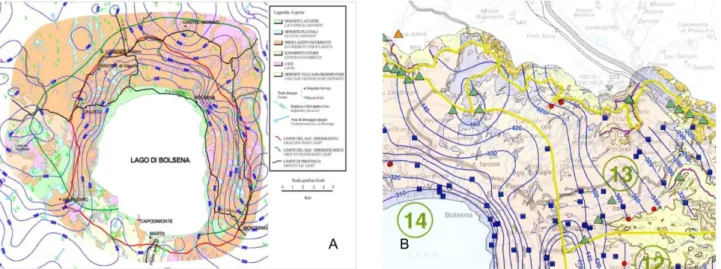
The basal aquifer of volcanic formations is considered a strategic resource in Umbria since many years. The first hydrogeological studies carried out in this area date back to the 80’s. Then in the 90’s Regione Umbria commissioned a complete work (Piano Lotti) in the NE sector of VVD to identify suitable hydraulic supply areas. Pagano et al (2000) analyzed the entire hydrogeological basin of Bolsena Lake. In their hydrogeological model (Fig 8A) the northern edge of the studied basin passed through Castel Giorgio Town, where a high load in water table elevation map was detected. The same hydrogeological pattern was taken up later by Capelli et al. (2005). Indeed the authors identified a groundwater divide coming from Castel Giorgio Town to Bagnoregio Town, that separates Marta Basin (basin n°14) from NE Vulsini basin (basin n°13) (Fig 8B), later revised by Di Matteo et al (2010) too.
Figure 8 A) Hydrogeological map realized by Pagano et al. (2000); B) Hydrogeological map realized by Capelli et al. (2005)
In this work previous geological and geophysical data were integrated to a new piezometric survey carried out in 2002 to realize a detailed hydrogeological conceptual model. Water table elevation data show the same anomaly level under Castel Giorgio as detected by previous works. In this area water table elevation reaches at about 460 m a.s.l.; this unexpected piezometric load could not be related neither to a structural high of sedimentary basement neither by the rising of deeper fluids according to water chemical data (ARPA Umbria 2013).
In these works the groundwater divide of the NE Vulsini hydrogeological basin (n°13 in Fig 8B) is close to volcanic slope in direction of Paglia Valley, it defines a not extended basin probably insufficient to recharge the very productive springs of Sugano and Tione characterized by a mean discharge of about 150 L/s.
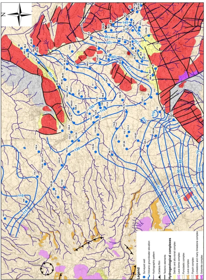
Hydrogeological characterization of the Umbrian sector of VVD has been carried out through geological analysis based on the previously described geological setting and in-field hydrogeological survey. The volcanic and sedimentary units outcropping in this area were included in five hydrogeological complexes. Each hydrogeological complex is composed by geological formations characterized by similar hydrogeological properties like permeability, capacities for infiltration and storage.
23
The defined hydrogeological complexes (Fig. 9) are as follows (modified from Capelli et al. 2005):
(Post volcanic units)
Eluvium complex: the products forming this complex derived from the weathering of
pyroclastic units. This complex is characterized by an average to low primary permeability due to abundant silty – clayey matrix. It has a variable thickness from few meters up to 15 – 20 near Castel Giorgio Town where it hosts a superficial aquifer
(Volcanic units)
Pyroclastic complex: pyroclastic deposits composing this hydrogeological complex
consist of alternating tuff, lapilli, pumice and minor volcanic ash characterized by a variable primary porosity due to its heterogeneity. In fact the presence of fine grain size levels reduces the vertical permeability of this complex. This hydrogeological complex has a thickness of several tens of meters and it hosts the main aquifer of volcanic units. Some low permeability deposits can support minor superficial aquifers
Lava complex: lava flows forming this complex are intrabedded in the pyroclastic deposits
and are characterized by variable thickness from 10 meters up to 60 meters. Lava are characterized by an average or high secondary hydraulic conductivity.
Ignimbritic complex: this complex corresponds to the Orvieto – Bagnoregio Ignimbrite
Formation. This formation is composed of pumice flow units, breccia deposits and pyroclastic flow deposits as previously described. This complex is characterized both by primary and secondary porosity.
(Pre volcanic units)
Pre volcanic complex: this complex corresponds to the pre volcanic sedimentary units; it
is composed of sand, silt and clay marine deposits and allochthonous units. This complex it is characterized by notability low hydraulic conductivity and constitutes the basal regional aquiclude of the volcanic aquifer.
24
Figure 9 Summary of hydrogeological complexes. Classes of permeability: L (low), A (average) and H (high). Types of permeability: P (primary), S (secondary) and K (karst)
Waters of volcanic aquifers are characterized by low mineralization (less than 300 mg/L), electric conductivity usually less than 500 S/cm and neutral pH values (7 – 7.5) (Frondini et al. 2013).Hydrogeochemical facies of groundwater is alkali – earth bicarbonate (Chiodini et al. 1982) and chemical composition of all volcanic aquifers is similar, with only minor differences related to rock – water interaction processes and residence time of water in volcanic deposits. In fact water of the basal aquifer is characterized by higher concentration in Na, Li, F, As and Si (Frondini et al. 2013).
25
3. Hydrogeological survey of Vulsini Volcanic District
A new hydrogeological survey was performed during the summer of 2013 in the Umbrian sector of VVD to improve the hydrogeological knowledge of this area.
As seen in the previous paragraph there are some uncertainties on the reliability of the previous works probably due to incorrect correlation of water table elevation. Alternation of pyroclastic deposits, characterized by different hydraulic conductivity, and lava flows allows the formation of superficial aquifers. The presence of these aquifers could alter the in situ measurements of water table elevation and chemical – physical analysis. In fact detected values could be the result of mixing of water from deep and shallow aquifer. This mixing process could take place on a large scale due to variability of thickness or the absence of the intermediate aquitard. In fact, as already described, intermediate aquitard is made up by lava flows characterized by an irregular pattern related to the paleo-morphology. Therefore in some areas the lack of these deposits doesn’t allow the distinction of aquifers. Other preferential mixing zones are located at the front of volcanic plateau. In fact outcropping lava show evidences of detensioning fractures that increase the permeability of these deposits. Sometimes boreholes could be a possible area where water mixing occurred. Incorrect cementing of well doesn’t isolate the shallow and the basal aquifer so water could percolate through the fractured zone outside well casing to underlying aquifer.
3.1. Materials and Methods
Wells with known technics information were measured during the survey due to the
hydrogeological heterogeneities of this area. All surveyed points were detected from LINQ (2013) database (Hydrogeological Laboratory of Roma Tre University) and ATI4 and Sii (2011) database in which boreholes characteristics were reported. Only deep wells,
draining the basal aquifer, were selected among all available data. Chemical analyses are another essential guideline to distinguish wells referring to different aquifers. Bibliographic chemical data (ATI4 and Sii, 2011) were collected in order to characterize some boreholes in the study area. Water table was detected in 18 boreholes, and its elevation was defined in meters above sea level (m a.s.l.) using traditional gauges and sonic meter water level gauge. The survey points for measurement of groundwater were private wells and drinking supply wells drilled into the volcanic deposits; the depth was variable from about 60 meters to more than 200 meters, and all measurements were performed under static conditions. Data about 40 springs were collected during the survey. For each point were reported information about elevation of spring outlet, about discharge rate and chemical – physical analysis. At first the elevation of springs outlet was an essential parameter to distinguish springs related to basal aquifer or to shallow one. Discharge rate measurements were realized using volumetric method in localized spring characterized by a flow rate less than 1 L/s. Flow measurements of diffuse or in high discharge rate springs were performed using a SEBA Hydrometrie M1 mini current meter and by analyzing the flow velocity along every discharge section (velocity area distribution of International Standards 2007).
26
The location of every survey point was obtained using a GPS, while the elevation of every point was determined from detailed geographic cartography resource (CTR – Carta
Tecnica Regionale 1:10.000). The topographic reference is the same used by other
authors to allow comparison among results. Water table elevation map was realized using experimental data and minor bibliographic references. The map was first hand-drawn using triangulation method with 10 meters of contour interval, in order to produce a detailed reconstruction, then it was digitalized and elaborated in a GIS system. It is possible evaluate some features of basal aquifer starting from realized hydrogeological map. At first a triangulated irregular networks (TIN) were created from linear shapefile representing water table elevation (m a.s.l.) and pre-volcanic deposits elevation (m a.s.l.). Then a subtraction of these two layers generates a new surface showing the thickness of saturated zone. The depth of groundwater can be calculated subtracting water table elevation TIN to Digital elevation model (DEM) of the study area
3.2. Results
Hydrogeological data collected during the survey were analyzed in order to delete anomalous data did not referred to the basal aquifer. According to ATI4 and Sii (2011) molar ratio between Lithium and Rubidium is a significant marker between deep and shallow aquifers. In fact molar ratio value between these two metals, belonging to the alkali metal group, is close to 1 in rainfall waters. Therefore shallow aquifers, defined by rapid discharge with little water – rock ion exchange, show values of molar Li/Rb nearby 1. Whereas samples of water of basal aquifer are characterized by higher molar Li/Rb values due to relative enrichment of Lithium. This different concentration of Lithium in water could be relate to long time storage in volcanic reservoir or to the leaching of marine clays lying under VVD deposits. Therefore these analyses, where available, could identify the
measured aquifer The hydrogeological map (Fig 9) depicts a clear reconstruction of two hydrogeological basins separate by a dynamic groundwater divide. It has NW-SE direction and its water table elevation decrease south-eastward from 460 m a.s.l. (near Castel Giorgio Town) to 420 m a.s.l. (near Torre S. Severo Town).The first basin corresponds to the south-western area of Umbrian VVD and it belongs to Bolsena Lake hydrogeological basin. The second detected hydrogeological basin belongs to Paglia River basin. The southern boundary of this basin corresponds to the dynamic groundwater divide whereas the other boundaries are marked by the outcropping limit of volcanic deposits. The main groundwater flow direction is north-eastward towards the base of volcanic slope. This sector of VVD is the recharge area of several springs characterized by different discharge rate, from 1 L/s up to more than 100 L/s. The most productive springs are used for
drinkable water supply (Sugano 1 Spring, Sugano 2 Spring and Capita Spring) or bottling of mineral water (Tione Spring).It’s important monitor the morphology of dynamic
groundwater divide and its variations in time in order to preserve water reservoir since these springs are important resources for population.
The comparison of data collected in 2011 and in 2013 hydrogeological surveys, evidences only minor differences in water table elevation (Δ = ±2 m). No significant variations of water table morphology were detected then the two hydrogeological basins maintain the same recharge areas.
27
28
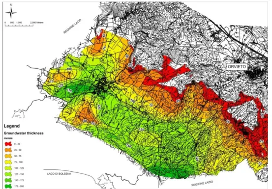
Groundwater thickness was calculated in a GIS system. The aquifer thickness reaches southward up to 200 meters due to the steep deepening of basal aquiclude (Fig 11); whereas it decreases up to few meters close to the springs on volcanic slope. Some anomalies were caused by the presence of morphological high of sedimentary deposits as can be seen south of Castel Giorgio Town.
Figure 11Map of groundwater thickness of the basal volcanic aquifer
The map of groundwater depth evidences a progressive increase of the depth of the aquifer south-westward up to 250 meters (Fig. 12). The minor values correspond to the volcanic front where several springs were detected. This reconstruction is one of the most important parameters to determinate the vulnerability of the aquifer.
29
4. Roccamonfina Volcanic Complex
4.1. Geological settings
The Roccamonfina Volcano is part of the Ernici – Roccamonfina Volcanic Province located between the Roman (to the north) and the Campanian (to the south) magmatic provinces. The Ernici – Roccamonfina Province is a transitional zone between roman and campanian volcanoes (Fig 10) (Peccerillo 2005). These provinces belong to the volcanic belt of the Tyrrhenian margin.
Figure 13 Perythirrenic Volcanism (Peccerillo 2005)
The origin of this magmatic activity is related to the eastern extensional structures of the Tyrrhenian basin, between the orogenic belt of the Apennines and the slow spreading center of the Tyrrhenian Sea. To the East of the Apennines, the Apulian micro-plate is subducted beneath the European plate, a convergent margin which is believed to be responsible for a classical arc-tectonic association of collision and extension, and onset of calcalkaline to ultra-potassic volcanism typical of the central-southern Italy (Peccerillo 2005).Roccamonfina lies at the intersection of a main NW – trending tectonic depression and the transverse, NE – oriented Garigliano Graben(De Rita and Giordano 1996). The main evolution of this graben during the Early Pleistocene was controlled by extensional Mount Massico fault at the northwestern border of Mount Massico structure (Nicotera and Civita 1969, Ippolito et al. 1973)
30
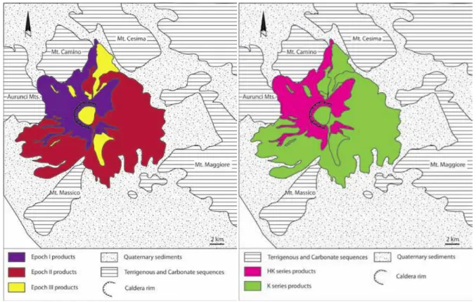
4.2. Geological evolution
The activity of the Roccamonfina began about 630 ka and ended around 53 ka (De Rita and Giordano 1996). Its activity is subdivided into three main epochs (Fig 14), corresponding to three different supersynthems (De Rita et al. 1997):
The first one (630-385 ka) is characterized by the growing of the stratovolcano and several small volcanic centers. During this epoch about 100 km3 of mainly lava were erupted. The volcano edifice collapsed at the end of this phase.
The second activity epoch (385-230 ka) is characterized by a succession of highly explosive eruptions and about 10 km3 of magma DRE were erupted
The last phase lasted until 53 ka. During this period minor freatomagmatic activity (1km3 of magma DRE erupted) and lava domes occurred.
RVC evolution can be subdivided into two geochemical stages according to Appleton (1972). They correspond to two different magmatic series: the high-Kseries (HK), rich in leucite, and the low-K series (K), poor in leucite (Fig 15). The activity of the stage I characterized mostly the volcanic history of Roccamonfina, from 630 to 340 ka (Giannetti 1979; De Rita and Giordano 1996) with the emplacement of deposits characterized by the compositional interval from leucitic-tephrite to phonolite.
Figure 14Sketch of the distribution of the three different activity epochs products (modified from De Rita and Giordano 1996)
Figure 15The subdivision of the Roccamonfina volcanic products in HK and K magmatic series (modified from De Rita and Giordano 1996)
The First Epoch
The first epoch is mainly characterized by effusive activity with the emission of sub-saturated lava flows. A dating on lava deposits on the western flank of the volcano gave an
31
age of about 630 ka (Giannetti 1979), so the activity probably began before this data. Several parasitic centers were emplaced, such as Tuoro Piccolo and Mt. Capitolo (Cole et al. 1992; Rouchon et al., 2008). According to geochemical data of Appleton (1972), this epoch was characterized by the eruption of HK series magma having various parental melt compositions, differentiated dominantly at deep crustal levels.
The Second Epoch
At the end of Stage I a series of explosive eruptions emplaced a group of eight pyroclastic flow deposits (Santello 2010) called Brown Leucitic Tuff (BLT)( Luhr and Giannetti 1987). The onset of BLT (385- 325 ka) eruptions are marked by the upwelling of magmas derived from higher degrees of partial fusion, and less contaminated by subduction than the rest of HK series products. This may confirm the idea of Marra et al. (2004) about the existence of melt production cycles in the underlying lithospheric mantle. The BLT places itself between HK and K series products. Thus, it postdated the last HK series lavas, while the early K series lavas were erupted after the BLT. Actually the relationship between BLT and the main caldera has been highly debated during decades (Capuano et al. 1992, Cole et al. 1992, Chiesa et al. 1995, De Rita and Giordano 1996, Giannetti 2001). The formation of this crater by a caldera - forming event (e.g. deep reservoir collapse) was rejected by Watts (1987) and De Rita and Giordano (1996) after deep borehole investigation of the main crater, which did not indicate the presence of a disrupted or subsided basement. Alternatively, it has been suggested that the main caldera resulted from a lateral sector collapse linked to the eruption of the BLT (Watts, 1987; Chiesa et al. 1995) or to the instability of the eastern flank as a result of its continuous down throwing by the Mt. Massico fault (De Rita and Giordano 1996, Santello 2010). The K stage started at about 320 ka with the deposition of the White Trachytic Tuff (WTT) (Giannetti and De Casa 2000). The lower part of these deposits (LWTT) represents about 80% vol of the whole WTT succession. It contains frequent lithic accumulation zones of clasts derived from the demolition of the main cone, and dominantly from trachyandesite units in the main crater (Giannetti and De Casa 2000). Although the volume of the outcropping effusive products of the K stages is rather small in comparison with those of the HK stages. After LWTT activity, a number of trachybasaltic and shoshonitic parasitic centers erupted, (Rouchon et al. 2008). The main crater activity was also characterized by the emplacement of the shoshonitic basalts and by strombolian activity in the main crater dated 245-232 ka (Rouchon et al. 2008). Upper-WTT units represent limited erupted volumes related to localized explosions, emplaced 230 ka (Giannetti and De Casa 2000).
The Third Epoch
The end of the K series corresponds to the third and last supersynthem of the Roccamonfina volcano history (De Rita and Giordano 1996). The final stages consists of localized phreatomagmatic eruptions that led to the production and emplacement of the Yellow Trachytic Tuff (YTT) 227 ka from the N flank of the volcanic edifice, which result in the maar–shape of the northern crater (Giannetti 1996).
This epoch includes the building of Mt. S. Croce lava dome (dated about 150 ka) and Mt. Lattani lava dome (dated about 170 ka) and minor explosive eruption. They represent the most recent activity inside the caldera (Giannetti 1964).
32
4.3. Hydrogeological setting
Stratigraphic units can be combined into hydrogeological complexes having a similar hydraulic behavior according to their physical features. Within each complex may exist areas of non-homogeneity due to variable intensity of fracturing of lavas or limestone and to different primary porosity in stratified pyroclastic deposits. Eight hydrogeological
complexes (Fig. 16) were defined using information from bibliographic works (Matta et al. 2013 and Capelli et al. 1999):
(Post volcanic units)
Detritic and alluvial deposits complex: this complex is composed by reworked
sediments deposited at the base of slopes or in fluvial valley. These deposits could host restricted aquifers due to their high primary permeability
(Volcanic units)
Lava dome complex: this hydrogeological complex is composed by all lava dome of
Roccamonfina activity and they are the preferential areas of effective infiltration on the volcanic edifice due to several cooling fractures that produce high secondary permeability
Pyroclastic complex: this complex is composed by pyroclastic flow deposits and
pyroclastic fall deposits. These deposits have an average permeability due to their vertical heterogeneity.
Lava complex: this hydrogeological complex includes all lava flows emplaced during the
Roccamonfina evolution. These lava are mainly characterized by secondary high hydraulic conductivity due to cooling fractures. They often lie over relative lower permeability
deposits so lava flows could host superficial aquifers (Pre volcanic units)
Flysch complex: this complex is composed by clay and calcarenite of miocenic flysch.
These units are characterized by low relative permeability and sometimes they host unproductive aquifers in sandy layers characterized by relative higher primary porosity
Limestone and marly limestone complex: This complex is usually notably permeable
with good transmissivity and storage due to its fractures and karst features; moreover it host a regional aquifer recharged by surrounding carbonate ridge.
Dolomite complex: this hydrogeological complex is composed by Triassic dolomite and
dolomitic limestone and it’s characterized by a relative lower permeability than calcareous and marly complex due to minor karst features. This complex is therefore considered an aquitard of the regional carbonate aquifer.
Another volcanic complex was described in Capelli et al. (1999) but this complex doesn’t outcrop in the study area; it was only identified in some boreholes (Watts 1987) in
Roccamonfina caldera
Volcanic breccia complex: This breccia is composed of fragments of lava deriving from
33
and Giordano 1996). The scarce presence of matrix gives a good hydraulic conductivity to this breccia
Figure 16 Summary of hydrogeological complexes (modified from Mazza et al. 2013). Classes of permeability: L (low), A (average) and H (high). Types of permeability: P (primary), S (secondary) and K (karst)