Alma Mater Studiorum – Università di Bologna
DOTTORATO DI RICERCA IN
SCIENZE DELLA TERRA
Ciclo XXV
Settore Concorsuale di afferenza: 04/A2 Settore Scientifico disciplinare: GEO/02
LATE QUATERNARY GEOLOGICAL EVOLUTION OF THE
MONTENEGRO AND NORTHERN ALBANIA CONTINENTAL
MARGINS
Presentata da: Fabrizio Del Bianco Coordinatore Dottorato
Prof. Vincenzo Picotti
Esame finale Relatore Luca Gasperini Correlatori Mariangela Ravaioli Federico Giglio Giovanni Bortoluzzi anno 2014
3
INDEX
ABSTRACT ... 5 RIASSUNTO ... 7 PREFACE ... 9 CHAPTER 1 - Introduction ... 131.1 The Montenegro and Northern Albania continental margins in the Mediterranean Sea ... 14
1.2 Late Quaternary sea level changes, the last glacial-interglacial transition and its stratigraphic signature in the Adriatic Sea ... 17
1.3 Physiography of continental margins ... 20
References ... 23
CHAPTER 2 - The study area ... 27
2.1 Morphology and oceanographic setting of the Adriatic Sea ... 28
2.2 Geodynamic and structural setting of Montenegro and Northern Albania continental margins ... 30
References ... 36
CHAPTER 3 - Morphology, present-day sediment dispersal system, and Late Quaternary depositional sequences along the Montenegro/N. Albania continental margin ... 39
3.1 Introduction to scientific papers ... 40
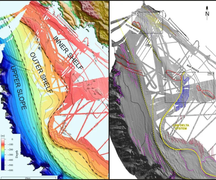
3.2 Seafloor morphologies of the Montenegro / Northern Albania continental margin ... 43
Figures with caption ... 59
References ... 69
3.3 Stratigraphic architecture of the Montenegro / Northern Albania continental margin ... 73
Figures with caption ... 90
References ... 101
3.4 Present-day sedimentation patterns along the Montenegro / N. Albania continental margin ... 109
Figures with caption ... 116
References ... 121
CHAPTER 4 – Discussion and conclusions ... 125
4.1 Discussion ... 126
4.2 Conclusions ... 131
References ... 135
APPENDIX ... 137
A.1 Abstract published on CIESM ... 138
A.2 Some concepts about physics of sound in water media ... 141
A.3 Multibeam bathymetry ... 144
A.4 The “Chirp” sub-bottom profiler ... 147
5
ABSTRACT
The object of this work has been the analysis of natural processes controlling the geological evolution of the Montenegro and Northern Albania Continental Margin (MACM) during the Late Quaternary. These include the modern sediment dispersal system and oceanographic regime, the building and shaping of the shelf margin at the scale of 100 kyr and relative to the most recent transition between glacial and interglacial periods.
A preliminary bibliographic research on these subjects has revealed the scarcity of marine geological/geophysical data in this sector of the Mediterranean, in contrast with the large amount of recent scientific works carried out on the western counterpart of the Adriatic Sea, e.g., the Italian coasts. Subsequently, acquisition and processing of data collected during several oceanographic cruises led us to obtain a high-resolution morphobathymetric map of the margin, which allowed us to carry out a morphological analysis of the region and to identify different physiographic domains. The presence of peculiar morphologies was suggestive of recent changes in the paleo-oceanographic condition, compared to the present-day regime. The following step was the combined interpretation of multibeam and high-resolution seismic reflection data to describe the MACM shelf-slope system. We observed that it is formed by a suite of physiographic elements, including: (1) an inner and an outer continental shelf of variable length, separated by two tectonically-controlled morphological highs (the Bar and Kotor ridges); (2) a lobated drowned mid-shelf paleodelta, formed during the last sea level fall and low stand; (3) an upper continental slope, affected by gravity-driven instability and a system of extensional faults with surficial displacement, featuring an orientation coherent with the regional tectonics.
At this stage, an acoustic characterization of the seafloor, ground-truthed by the analysis of seafloor sediments sampled at several stations, was attempted. It was then possible to subdivide the MACM seafloor types into four classes (low, medium, medium-to-high and high reflectivity areas), based on reflectivity, grain-size analysis of seafloor sediments and characterization of the acoustic facies. We observed that accumulation of low reflectivity deposit is limited to two sectors in the inner shelf and the upper slope, while the remaining areas, lacking of fine-grained sediments, show high reflectivity, suggesting that they are presently site of non-deposition/erosion. This preliminary phase was necessary due to the large amount of marine geophysical data collected within the ADRICOSM-STAR project, and the wide extent of the study-area, that called for identification of representative sectors where focusing our analysis.
The stratigraphic study of the shelf-slope system benefitted from the availability of high-resolution seismic reflection profiles, AMS 14C datings, 210Pb/210Po curves, and the study macrofossils
6
associations sampled at key gravity core stations. In this way, we observed a clear correspondence between the Late Pleistocene/Holocene mud-wedge and the low reflectivity sectors of the inner shelf, which represent the most important depositional areas during the present-day sea level highstand phase. Conversely, most of the outer shelf and part of the continental slope expose deposits from the last sea level low stand (Lowstand Systems Tract), featuring a general condition of lack in sedimentation or the presence of localized thin post glacial sediment cover.
In term of vertical movements, the MACM shows uplift in correspondence of the Kotor and
Bar ridges, and subsidence in the outer shelf and upper slope sectors, as suggested by the analysis of
the LGM paleoshoreline. In fact, seaward of these uplifting tectonic ridges, we observed a continuous stacking of stratigraphic sequences controlled by sea level fluctuations. Four sequences, interpreted as forced regression deposits, were identify, corresponding to the last four main glacial maxima, starting from Marine Isotopic Stage (MIS) 10. In this way, the MACM records the 100 kyr scale sea level fluctuations on its seismo-stratigraphic architecture over the last 350 kyr. Over such time range, encompassing MIS 10.2, 8.2, 6.2, 2.2, we estimated an average subsidence rate of about 1.2 mm/yr.
Finally, a preliminary analysis of geochemical proxy (C, N, 13C) confirmed the sediment
distribution inferred on the basis of geophysical and sedimentological analysis, and suggest that the particles input from Buna/Bojana River are displaced towards SE-NW along the Montenegro coasts by longshore currents.
7
RIASSUNTO
L’obiettivo di questo lavoro è stato quello di analizzare i processi naturali che hanno controllato l’evoluzione del Margine Continentale del Montenegro e dell’Albania Settentrionale (MACM) durante il tardo Quaternario. Tali processi includono il sistema attuale di dispersione del sedimento ed il regime oceanografico, la formazione ed il modellamento del margine alla scala dei 100 ka e relativamente all’ultimo periodo di transizione dal glaciale all’interglaciale.
Inizialmente il lavoro ha previsto una fase conoscitiva della zona attraverso la ricerca bibliografica dello scarso materiale scientifico disponibile e pubblicato. Successivamente, dopo una prima fase di acquisizione, processing ed unione dei dati delle diverse campagne oceanografiche, sono state prodotte le mappe batimetriche ad alta risoluzione alla scala dell’intero margine per poter effettuare un’analisi morfologica mirata all’individuazione dei differenti domini fisiografici. Successivamente, l’interpretazione combinata dei dati multibeam e di quelli di sismica a riflessione ad alta risoluzione ha permesso di osservare che il MACM è un sistema piattaforma-scarpata caratterizzato da: (1) una piattaforma interna ed una esterna a larghezza variabile dove sono presenti due alti morfologici a controllo tettonico, i ridges di Bar e di Kotor; (2) un delta trilobato relitto attribuito all’ultima fase di caduta del livello marino e (3) una scarpata continentale superiore affetta da processi gravitativi superficiali e da sistemi di faglie estensionali a rigetto superficiale che mostrano un’orientazione coerente con la tettonica regionale.
La seconda fase del lavoro è stata finalizzata alla caratterizzazione acustica del fondale marino, calibrata con le analisi granulometriche dei sedimenti superficiali. Questa caratterizzazione ha permesso di suddividere il MACM in quattro principali classi acustiche (low, medium, medium to
high and high reflectivity areas) evidenziando la variabilità nella distribuzione dei depositi
superficiali, e mostrando la presenza di depositi a bassa riflettività confinati in due bacini lungo la piattaforma interna ed in parte della scarpata superiore. Le altre zone, prive di sedimenti fini, appaiono altamente riflettenti e suggeriscono la presenza di processi di erosione o di non deposizione. Data l’enorme mole di dati geofisici marini acquisiti grazie al progetto ADRICOSM-STAR, questa seconda fase è stata fondamentale perché ha permesso di individuare le zone di indagine dove successivamente sono state analizzate le geometrie interne dei corpi sedimentari superficiali.
In questa terza ed ultima fase del lavoro di dottorato, avvalendosi dei dati di sismica a riflessione, delle datazioni del radiocarbonio, delle analisi del 210Pb/210Po e dello studio delle
associazioni dei macrofossili, è stato osservato che il cuneo fangoso tardo Pleistocenico-Olocenico corrisponde alle zone a bassa riflettività individuate sulla piattaforma interna e che risulta delimitato verso mare da alti strutturali. La piattaforma esterna e parte della scarpata continentale mostrano
8
sedimenti più antichi attribuibili alla fase dell’ultimo stazionamento basso del livello marino (ultimo
Lowstand Systems Tract - LST), risultando generalmente prive di sedimentazione attuale o localmente
ricoperte da sottili strati di sedimenti postglaciali. In corrispondenza dei ridges di Kotor e Bar, a controllo tettonico, il margine mostra un comportamento di stazionarietà verticale o di sollevamento localizzato, come suggerito dall’analisi geomorfologica effettuata sull’attuale profondità della paleo-linea di costa riferita all’ultimo massimo glaciale, che attraversa il ridge di Bar. All’esterno di questi
ridges tettonici, entro le profondità osservate attraverso i profili sparker, si nota la presenza di una
sovrapposizione continua di sequenze stratigrafiche controllate principalmente dalle variazioni del livello marino. Infatti, sono state identificate quattro sequenze attribuibili a depositi di regressione forzata formati durante le ultime quattro principali glaciazioni, a partire dallo stadio marino isotopico 10 (MIS 10). Il MACM registra quindi le variazioni del livello marino alla scala dei 100 ka nella sua architettura stratigrafica, durante gli ultimi ~350 ka. In questo intervallo temporale, attraverso l’individuazione della profondità delle paleo-linee di costa attribuibili al picco delle ultime 4 glaciazioni (MIS 10.2, 8.2, 6.2, 2.2) è stata effettuata una stima approssimativa del tasso di subsidenza secondo un modello di regressione lineare semplice che mostra valori di circa 1,2 mm/a.
Ulteriori studi basati su un approccio geochimico (C, N, 13C) confermano la distribuzione
sedimentaria osservata nei depositi di piattaforma interna e suggeriscono che gli apporti del fiume Buna/Bojana vengano dispersi in direzione SE-NO lungo la costa del Montenegro in accordo con l’andamento dell’attuale regime oceanografico.
9
PREFACE
The continental margins of the Mediterranean Sea have been the subject of intensive studies during the last decades, following the developments of geological and geophysical techniques applied to the marine environment. In such studies, the combined analysis of high-resolution morphobathymetric data, seismic reflection profiles and sediment samples has proved to be very effective to unraveling the complex interplay between sea level changes, sediment supply, and accomodation driven by tectonic processes. In the Adriatic Sea case, although the western shelf was extensively investigated by marine geological and oceanographic cruises, its eastern side, and in particular the southeastern sector, remains poorly covered by high-quality marine geological data. The Montenegro/Northern Albania Continental Margin (MACM) is part of this sector, and do not constitutes an exception, because the knowledge of its morphology, stratigraphy and tectonic processes is still very limited. A recent acquisition of marine geological/geophysical and biogeochemical data partially fills this gap. In fact, from 2008 to 2010 several oceanographic cruises, organized by the Italian National Research Council (CNR) – Institute of Marine Science (ISMAR) Section of Marine Geology in Bologna onboard of CNR research vessels, investigated the MACM. The analysis of this set of data constitutes the subject of the present PhD thesis.
The geological analysis of the MACM started with the collection of the few literature available for the study area. It appeared that most of the available work is based on unpublished multichannel seismic lines, collected for industrial purpose and not available to the wider audience, if we exclude few sections and line drawings used to describe the deep-seated geological structures. Typical marine geological studies are lacking in this area, including analyses of geological processes that led to the reconstruction of the present-day oceanographic setting and sediment dispersal as well as the Late Pleistocene/Holocene stratigraphic architecture. Thus, we decided to follow a multidisciplinary approach that included the analysis of multibeam-based morphobathymetric maps, seismic reflection profiles at different degrees of penetration, and sediment samples to address the reconstruction of the recent geological evolution of the margin.
The first part of the work during this PhD thesis was focused on the acquisition and processing of bathymetric and seismic reflection high-resolution data, and included participation to five oceanographic cruises aboard R/V Mariagrazia (MNG02, 2009) and R/V Urania (ADR02, 2008; MNG01, 2009; MNG03, 2010 and MNG04, 2010), both part of the CNR research facilities. Geophysical data collected during those expeditions, i.e. multibeam swath bathymetry and seismic reflection profiles, were used to study the physiography of the margin, and the distribution of Late Quaternary sediments, as well as the geometries of depositional basins as result of several geological
10
processes. These data were integrated with the analysis of bottom and sub-bottom sediments carried out through box- and gravity-corer, collected in different sectors of the MACM. After collection of magnetic susceptibility, logs and x-ray imaging, the cores were described and sub-sampled for porosity, grain size, and 14C- 210Pb radiometric analyses.
The dataset used in this work constitutes the first example of this type in the area, and was collected in the frame of the ADRICOSM-STAR Project (ADRIatic sea integrated CoaStal and river basin Management system: Montenegro coaSTal ARea and Bojana River catchment) with the financial support of the Italian Ministry for the Environment, Land and Sea and coordinated by
Istituto Nazionale di Geofisica e Vulcanologia (INGV) and Centro Euro-Mediterraneo sui Cambiamenti Climatici (CMCC). In this project, ISMAR provided geological-geophysical and
biogeochemical data in support of sustainable coastal management and sedimentary dynamics/physical oceanography modeling. In addition, by reconstructing the Late Quaternary to present-day sediment distribution along the margin, it was possible to obtain an independent evidence to test and validate model results by the other project’s partner.
This PhD thesis is based on a series of scientific papers (2 already submitted and 1 in preparation), which address specific aspects of the recent geological evolution of the MACM, such as the morphology, evidenced by multibeam data collected on the shelf and upper slope, the Late Quaternary stratigraphy, as well as an analysis of the present-day sediment dispersal system based on geochemical tracers. These interrelated subjects are discussed in the frame of the geodynamic setting of the study area and within a specific chapter (“Discussion and Conclusions”), which highlights the main findings of the analytical work.
In more detail, this work is organized according to the following sequence:
(i) a first chapter (CHAPTER 1 – Introduction), aimed to introduce the scientific rationale of the work;
(ii) a second chapter (CHAPTER 2 – The study area), in which an analysis of the geology of the study area is presented; this chapter includes information about geodynamic/structural setting and oceanography available on literature;
(iii) a third chapter (CHAPTER 3 - Morphology, present-day sediment dispersal system, and Late Quaternary depositional sequences along the Montenegro/N. Albania Continental Margin) including two scientific papers already submitted to international journals, and one in preparation: 1)- "Seafloor morphologies along the Montenegro/N. Albania Continental Margin (Adriatic Sea - Central Mediterranean)" submitted to the Geomorphology, which
11 encompasses all aspects of the large-scale morphologies and shapes along the bottom analyzed; 2)- "Stratigraphic architecture of the Montenegro/N. Albania Continental Margin (Adriatic Sea - Central Mediterranean) " submitted to Marine Geology, which includes stratigraphic studies carried out on the MACM; 3)- "Present-day sedimentation patterns along the Montenegro/N. Albania Continental Margin from geochemical analysis (Adriatic Sea - Central Mediterranean)", in preparation which dealing with the study of the present-day sediment dispersal system through the use of geochemical tracers;
(iv) a fourth chapter (CHAPTER 4 – Discussion and Conclusions) integrating discussion of the various topics analyzed and their mutual connections with a final conclusions;
(v) a final appendix containing a conference abstract developed during the first stage of the PhD and the description of the geophysical techniques and methods used in the thesis work.
13
CHAPTER 1
--
14
1.1 The Montenegro/Northern Albania Continental Margin in the Mediterranean Sea
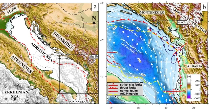
The geological evolution of the continental margins reflects the interaction of natural processes at different scales. The most significant among them are type and amount of sediment inputs, relative sea level changes and oceanographic regime that redistribute sediments along different physiographic domains. Each process is controlled over different time-scales by regional tectonics that could cause uplift or subsidence in different sectors, creating space for sedimentary sequence to be preserved. Due to their complex geological evolution, the continental margins along the Mediterranean Sea show a wide variety of geological and geodynamic settings. The presence of fold-and-thrust orogenic belts, extensional basins, and remnants of old oceanic crust, almost entirely subducted below the continent, lead to the presence of a wide variety of margin types, separated one to each other by relatively short distances.
The Montenegro/Northern Albania Continental Margin (MACM, Fig1.1) constitutes a peculiarity among the peri-Mediterranean margins, because it lacks of high quality marine geological/geophysical data. This area is located in the southeastern sector of the Adriatic Sea and includes the entire Montenegro and the Northern Albania coastlines. It is limited to the N by the political boundary between Montenegro and Croatia, located immediately northwest of the Bokakotorska Bay, and to the S, in Albania, by the Cape Rodonit and the outflow of the Drini River (Fig. 1.1).
From the point of view of geodynamics, the MACM is a convergent margin formed at the front of the Dinarides fold-and-thrusts system belt, whose tectonic structure encompasses the shelf and the continental slope. A preliminary neotectonic study based on the analysis of both, newly collected and published data in Del Bianco et al. (2010) suggests that some of the shallow deformations observed along the MACM are related to the compressive regime along the more external Dinaric thrusts and to transpressive faults located near the Montenegro/Albania boundary. This hypothesis, although in agreement with seismological studies (Anderson and Jackson, 1987; Pondrelli et al., 2002; Hunstad et al., 2003), is supported by the analysis of shallow seismic reflection images only, and should be confirmed by deeper structural data.
Historical catalogues (ANSS 1963-2009) and instrumental records (Pondrelli et al., 2006) show that this region is one of the coastal zones in the Central Mediterranean more prone to seismic hazard. The list of large earthquakes occurred in the near past include (i) the M=7 Dubrovnik event (April 6 1667), (ii) the M=6.5 of June 13, 1593 event with epicenter close to Kotor, and (iii) the destructive June 1, 1905 event, close to Skadar. The most recent large magnitude (Mw 7.1) earthquake occurred on April 15, 1979 offshore Montenegro, between Bar and Ulcinj. The hypocentre of the
15 1979 mainshock was located along a shallow (7 km deep), low angle (14°) thrust fault, parallel to the coastline and dipping to the NE (Benetatos et al., 2006). This latest event highlighted the importance of marine geological studies along the MACM to understand how deformations originating from deep-seated seismogenic structures reflect on the uppermost sedimentary sequence, and could eventually affect the seafloor morphology.
Fig.1.1. Geographical setting of Montenegro/N.Albania Continental Margin (MACM).
Regarding available marine geological/geophysical data, the closest example is a set of multichannel seismic reflection profiles acquired along the Albania offshore (Argnani et al., 1996) which, however, do not reach the MACM. Data acquired by the oil companies starting from the ’70, potentially useful to study relationships between shallow and deep geological structures, are not currently available except for a few examples (Dragasevic, 1974, 1983; Oluic et al., 1982; Aliaj et al., 2004; Aliaj, 2008).
16
as a reference the well-studied western Adriatic margin. Here, it has been shown that since the Middle Pleistocene, the high-frequency glacio-eustatic fluctuations are the primary controlling factor for the cyclical deposition of sedimentary units (Trincardi and Correggiari, 2000; Ridente and Trincardi, 2002). This effect, combined with a progressive tilting of the shelf due to regional subsidence, allowed for preservation of a relatively expanded sedimentary sequence. This includes deposits from all different stages of the climate cycles, such as the Highstand (HST), the Falling-stage (FSST), the Lowstand (LST) and the Transgressive (TST) systems tract, differently preserved and widely recovered and studied in the Adriatic Sea and in other Mediterranean margins (e.g. Tesson et al., 1990; Trincardi and Field, 1991; Piper and Aksu, 1992; Gensous and Tesson, 1996; Chiocci et al., 1997; Bernè et al., 1998; Skene et al., 1998; Somoza et al., 1998; Ridente and Trincardi, 2002; Maselli et al., 2011).
The eastern and western Adriatic shelves are characterized by similar geodynamic settings and a common history of Late Quaternary paleogeographic changes, culminated ~21 kyr in the last episode of glacio-eustatic low stand (-120 m below the present-day datum; Clark et al., 2009). In its northern part, the western Adriatic is characterized by high accomodation related to the constant and relatively high subsidence rate at the front of the Apennine Chain. South of the Mid Adriatic Depression (central Adriatic Sea), compressive deformations reach the uppermost part of the stratigraphic sequence (Ridente and Trincardi, 2006), as well as in other areas where the Apennine Chain front intersects the coastline. In such zones, subsidence is highly variable, and sediments are locally affected by incipient tectonic deformations. Recently, Maselli et al. (2001) presented a compilation of subsidence rate estimates from several sources, in different sectors of the western Adriatic margin; these rates range from 1.2 mm/yr in the Northern, and 0.3 mm/yr in the Central Adriatic. Conversely, the Southern Adriatic shelf in correspondence of the Apulia swell is uplifting at rates in the order of 0.2-0.3 mm/yr.
However, the main factors that control the depositional sequences of the latest sea level cycles along the eastern Adriatic shelf, and an estimate of the vertical movement that characterizes the margin and creates accomodation for these sequences to be preserved, is not studied to date.
Unlike the few existing published work on the MACM that deal mainly with seismology or the description of deep tectonic structures, this work represents the first analysis of high-resolution morphobathymetric and seismic reflection data to study the geological evolution at the scale of the Late Quaternary. It thus represents a first marine geological description of the MACM, which includes a reconstruction of its morphology, an analysis of sediment distribution along the margin and its evolution in time during the Late Pleistocene-Holocene, as well as an estimate of the subsidence rate at the shelf-break based on combined seismo-stratigraphic and chrono-stratigraphic
17 analysis of selected sediment samples. Furthermore, a preliminary analysis of the relationships between deep tectonic structures and their expression at the shallow seafloor is presented. A final, not completely developed aspect concerns the analysis of modern distribution of sediments through a geochemical approach, which constitutes the main objective of the EC ADRICOSM-STAR project, the reference framework for data acquisition in this area.
The topics analyzed in this work are important for the comprehensive knowledge of the Adriatic Sea basin, and to determine the main geological factors that control the physiography and distribution of Late Quaternary sediments along a seismically active margin, such as the MACM, that develops above the outer tectonic structures related to the Dinarides Chain. Being the first work of its kind conducted in the MACM, it will also lay the groundwork for future research in more depth.
The following introductory paragraphs provide an overview on sea level changes during the Late Quaternary and an introduction to the physiography of the continental margins in convergent geodynamic settings.
1.2 Late Quaternary sea level changes, the last glacial-interglacial transition and its
stratigraphic signature in the Adriatic Sea
As previously mentioned, the glacio-eustatic sea level fluctuations during the Late Quaternary have played a key role in controlling the deposition of sedimentary units in the Adriatic Sea. For this reason, we will briefly summarize the studies about global sea level changes during this period.
At time scales of thousands of years, climate is characterized by important cyclic variations, linked to changes in Earth orbital parameters and axis tilting, which lead to variations in the effects of solar radiation in the two hemispheres of our Planet; this causes important climatic oscillation called “Milankovitch cycles”: (i) the eccentricity (the shape of the orbit and consequently the Earth-Sun distance) characterized by a period of ca. 100 kyr, (ii) the obliquity (the tilting of the Earth rotational axis) with a period of about 40 kyr and (iii) the precession (the direction of Earth rotational axis) with a period of about 20 kyr (Martinson et al., 1987; Ruddiman, 2006). The interaction between these different timescale cyclic variations are linked to the glacio-eustatic component of the sea level changes and the greatest observed response concerning the ice ages is at the 100 kyr timescales. This rather simplistic picture is however complicated by biological and abiological feedbacks, such as the changes in albedo, the bloom of micro-plankton and the modification of oceanic currents.
The reconstruction of past sea level oscillations is achieved using a variety of techniques, including geomorphology, geology and archeology, through direct sea level reconstruction by investigating geologic and geomorphologic features such as marine erosion features (e.g. Antonioli
18
et al., 2007), barrier-island-lagoon deposits (e.g. Törnqvist et al., 2004), coral-reef deposits and terraces (e.g. Fairbanks, 1989 and Bard et al., 2010). Another important contribution to the estimate of past eustatic levels is given by isotopic studies carried out on ubiquitous microfossils such as deep-sea foraminifera corroborated by numerical modeling and simulations (Lambeck and Chapel, 2001; Lea et al., 2002). In fact the δ18O (the ratio between 18O and 16O) in the ocean provide a time-averaged
record of deep-sea temperature and continental ice volume because it increases with the amount of ice on the poles. By combining isotopic sea level records with estimate based on dated coral reefs, which represent natural dipsticks for the eustatic level, several authors reconstructed eustatic oscillation in form of different sea level curves, such as that shown in Fig. 1.2 (Shackleton, 2000; Lea et al., 2002).
Fig.1.2. Compilation of two different sea level curves for the last 350 kyr modified from Shackleton (2000) and Lea et al., (2002). Red numbers refer to a Marine Isotopic Stage (MIS) from Lisiecki and Raimo (2005).
During the last glacial-interglacial transition, starting from about 19 kyr at the end of the Last Glacial Maximum (LGM, between 26 and 19 kyr cal. BP), the sea level rose from about -120 meters to its modern position (Clark et al., 2009). As highlighted by several authors, the last sea level rise (between ca. 19 and 5.5 kyr BP) was not monotonic, but punctuated by two main steps of enhanced ice melting (Fairbanks, 1989) (Fig. 1.3). The sea level curve shows at least two slope gradients due to intervals of enhanced fresh water discharge, called Meltwater Pulses 1A and 1B, starting at 14.2 kyr cal. BP and 11.3 kyr cal. BP, respectively (Fairbanks, 1989).
19
Fig.1.3. Sea level curve for the post – LGM time interval and other information from several authors. Red line is modified from Fleming et al. (1998).
During these phases, the sea level rose about 20 m in less than 500 yr (Bard et al., 1990, 1996; Clark et al., 2002).The meltwater pulses are separated by a short interval of climatic reversal that brought back to colder conditions, known as the Younger Dryas event (Allen et al., 1999). During the Late Quaternary, part of the western Adriatic shelves underwent significant subsidence, up to 1.2 mm/kyr (Maselli et al., 2010). This allowed for preservation a relatively expanded record of the last cycle, including the forced-regression deposits (e.g. Ridente and Trincardi, 2002). The uppermost seafloor stratigraphy of north and central Adriatic can be subdivided into two different domains. The shallower portion is characterized by clinoforms formed by sediments delivered to the basin by the Po River and others Apennine rivers after the maximum marine ingression, and confined landward by marine circulation (Cattaneo et al., 2003; Cattaneo et al., 2007). Conversely, the central portion of the northern Adriatic shelf is characterized by the diffuse presence of low stand alluvial plan deposits, covered by transgressive sandy beds of relict barrier-island systems, formed during to the last sea level rise (Correggiari et al., 1996).
The shallow stratigraphic architecture of the west Adriatic margin is composed of different stratigraphic units related to the Late Quaternary sea level changes (Cattaneo and Trincardi, 1999; Trincardi and Correggiari, 2000):
20
recorded a regressive phase encompassing most of the last glacial cycle, from marine oxygen isotope stage 5e to the base of the last glacial maximum (Trincardi and Correggiari, 2000; Ridente and Trincardi, 2002);
- the Transgressive Systems Tract (TST), resting above ES1, that recorded distinctive phases of the last sea level rise and short-term variations of sediment supply and dispersal (Cattaneo and Trincardi, 1999), likely accompanied by changes in the oceanographic regime of the basin (Asioli et al., 2001). Maselli et al. (2011) represents the recent-most summary for this.
- the Highstand Systems Tract (HST), consisting of a shore-parallel prograding mud prism, deposited during the last 5.5 cal kyr BP, which formed above a regional downlap surface (Maximum Flooding Surface, mfs; Correggiari et al., 2001; Cattaneo et al., 2003, 2004 and 2007).
1.3 Physiography of continental margins
Before moving to the next chapter, which describes the geological setting of the study area, it is important to describe how the study of the continental margin physiography could be approached using marine geophysical data.
A continental margin is defined as the outer edge of a major landmass and is generally formed by a sequence of shelf, slope and rise, from the innermost to the outermost physiographic domain, respectively. An alternative to the shelf-slope model is a ramp, proposed by Ahr (1973), not considered in this work. The continental shelf is the submerged part of the continents, between the coastline and the shelf-break, an abrupt change in the topographic gradient usually located at a depth of 100-160 m. The average topographic gradients on the shelf are some decimal degrees (typically < 1°) and for this reason it undergoes alternated sinking and sub-aerial exposure as a consequence of eustatic oscillations. The continental slope connects the shelf with the abyssal plain, and constitute the by-pass for density currents and hyperpycnal flows. In fact, along the slope we observe relatively high topographic gradients, from 1 to 10°, and typical morphological features associated to high-energy sedimentary processes, including mass wasting and deformation due to gravity driven instability. Continental shelves are generally sites for accumulation of thick stack of sedimentary sequences, characterized by complex structural patterns, and controlled by the combined effects of sediment supply, transport and deposition, as well as the effect of tectonics and erosional processes.
Active continental margins as the MACM, where lithospheric plates converge, coincide with plate boundaries where the upper and lower plates are separated by a subduction zone. These margins have lesser extents and sediment accumulation relative to passive margins, where thermal subsidence
21 plays a key role in creating accommodation for depositional sequences. One of the major factors controlling development of the continental shelves along active margins is the availability of sediment and its inputs from adjacent continental areas could contribute to the growth of the accretionary
prism, the wedge of deformed sediments stacking in front of subduction planes. When folded coastal
mountain chains develop, as part of a convergent margin, the drainage system may be limited and active continental margins are often characterized by small mountainous rivers carrying relatively large sediment loads to the narrow shelves (Milliman and Syvitski, 1992). Tectonic deformations can lead to the formation of mid-shelf synclinal basins, which can control sediment transport at different time-scales. For example, synclinal basins formed due to tectonic deformations on the shelf are the primary repositories of the Waipaoa and Waiapu River deposits in New Zeland, and the Eel River in California (Clarke, 1987; Foster and Carter, 1997; Lewis et al., 2004). Alternatively, with a more limited accommodation in case of over narrower shelves, most of the sediments delivered to collisional margins are transferred to the adjacent slopes and deep-sea basins during high sea level conditions (Milliman and Syvitski, 1992).
The stratigraphic architecture of a continental margin can be analyzed by unraveling the packaging of stratigraphic units from seismic reflection data. Vail et al. (1977) claimed to recognize a hierarchy of cycles of relative sea level change largely based on the depositional limits of onlaps and toplaps within the coastal facies of marine sediments. The primary meso-scale units of stratigraphy are the depositional sequences. They are coherent packets of genetically related strata correlated at a regional scale. Depositional sequence are recognized in the subsurface using seismic stratigraphic methods, because they are marked by bounding unconformities or laterally correlable conformities (Mitchum et al. 1977). Within each depositional sequence, individual strata can exhibit a variety of geometrical relationship to the depositional boundary. Onlaps, downlaps and toplaps indicate non-depositional hiatuses, whereas truncation indicates an erosional hiatus or the result of structural deformation (Vail et al, 1977). The depositional sequence boundary is useful on seismic reflection profiles because it can be easily recognized by a downward shift in the positions of coastal onlaps. A simplified sketch showing a general stacking pattern of depositional sequence on a typical continental passive margin is shown in Fig. 1.4.
22
Fig.1.4. Example of general morphologies of continental margin at the late TST phase and the ideal system tract model. Modified from Coe et al. (2003).
The sedimentary sequences in a tectonically active margin may be more complex relative to passive margins due to the tectonic effects. For this reason, analysis of the depositional patterns in margins such as the MACM, requires to separate the effect of vertical movements of the substratum, caused by tectonic deformation, and sea level changes caused by eustasy.
The following chapter provide a geological background of the studied area by the information available in literature, before passing to the analysis of the new data.
23 References
Ahr, W.M., 1973. The carbonate ramp-an alternative to the shelf model. Trans., Gulf Coast Assoc. Geol. Soc., 23: 221-225.
Aliaj S., Adams J, Halchuk S., Sulstarova E., Peci V. and Muco B. 2004. - Probabilistic seismic hazard maps for Albania. - 13th World Conference on Earthquake Engineering, Vancouver, B.C., Canada, August 1-6, 2004, Paper No. 2469.
Aliaj S. 2008 - The Albanian Orogen: convergence Zone between Eurasia and the Adria microplate. - In: N.Pinter, G.Gyula, S.Stein and D.Medak (eds.), The Adria Microplate: GPS Geodesy, Tectonics and Hazards, NATO Science Series, IY, Earth and Environmental Sc., Vol.61, Springer.
Anderson H. & Jackson J. 1987 – Active tectonics of the Adriatic region. Geophys. J. R. astr. Soc., 91,937-983
ANSS (Advanced National Seismic System) – Northern California Earthquake Data Center –
www.ncedc.org/anss
Antonioli F., Anzidei M., Lambeck K., Auriemma R., Gaddi D., Furlani S., Orrù P., Solinas E., Gaspari A., Karinja S., Kovacic V., Surace L., 2007 Sea-level changes during the Holocene in Sardinia and in the northeastern Adriatic (central Mediterranean Sea) from archaeological and geomorphological data. Quaternary Science Review 26, 2463-2486.
Argnani A., Bonazzi C., Evangelisti D., Favali P., Frugoni F., Gasperini M., Ligi M., Marani M. and Mele G. 1996. - Tettonica dell’Adriatico meridionale - Mem. Soc. Geol. It., 51, 227-237.
Asioli, A., Trincardi, F., Lowe, J. J., Ariztegui, D., Langone, L., & Old, F. (2001). Sub-millennial scale climatic oscillations in the central Adriatic during the Late glacial: palaeoceanographic implications, 20. Bard, E., Hamelin, B., Fairbanks, R.G., 1990. U–Th ages obtained by mass spectrometry in corals from
Barbados: sea level during the past 130,000 years. Nature 346, 456–458.
Bard, E., Hamelin, B., Arnold, M., Montaggioni, L., Cabioch, G., Faure, G., Rougerie, F., 1996. Deglacial sea-level record from Tahiti corals and the timing of global Meltwater discharge. Nature 382, 241–244. Bard, E., Hamelin, B., & Delanghe-Sabatier, D. (2010). Deglacial meltwater pulse 1B and Younger Dryas sea
levels revisited with boreholes at Tahiti. Science (New York, N.Y.), 327(5970), 1235–7. doi:10.1126/science.1180557
Benetatos C. and Kiratzi A., 2006. – Finite-fault slip models for the 15 April 1979 (Mw 7.1) Montenegro earthquake and its strongest aftershock of 24 May 1979 (Mw 6.2). - Tectonophysics 421, 129-143. Berne, S., Lericolais, G., Marsset, T., Bourillet, J.F., De Batist, M., 1998. Erosional onshore sand ridges and
lowstand shore- faces: examples from tide- and wave-dominated environments of France. J. Sediment. Res. 68, 540^555.
Cattaneo A., Trincardi, F., 1999. The late-Quaternary transgressive record in the Adriatic epicontinental sea: basin widening and facies partitioning. In: Bergman, K.M., Snedden, J.W. (Eds.), Isolated Shallow Marine Sand Bodies: Sequence Stratigraphic Analysis and Sedimentologic Interpretation, Spec. Publ. SEPM, 64, 127–146.
Cattaneo A., Correggiari A., Langone L., Trincardi F. 2003. The Late-Holocene Gargano subaqueous delta, Adriatic shelf: sediment pathways and supply fluctuations. Marine Geology, 193: 61-91.
24
Cattaneo, A., Correggiari, A., Marsset, T., Thomas, Y., Marsset, B., & Trincardi, F. (2004). Seafloor undulation pattern on the Adriatic shelf and comparison to deep-water sediment waves. Marine Geology, 213(1-4), 121–148. doi:10.1016/j.margeo.2004.10.004
Cattaneo A., Trincardi F., Asioli A., Correggiari A. 2007. Clinoform formation in the Adriatic Sea: energy-limited bottomset. In Milligan T.G., Cattaneo A., (Eds.), Special issue, Sediment dynamics in the western Adriatic. Continental Shelf Research, 27: 506-525.
Chiocci, F.L., Ercilla, G., Torres, J., 1997. Stratal architecture of Western Mediterranean Margins as the result of the stacking of Quaternary lowstand deposits below glacio-eustatic fluctuation base-level. Sediment. Geol. 112, 195–217.
Coe, Angela L.; Bosence, Dam W.J.; Church, Kevin D.; Flint, Stephen S.; Howell, John A. and Wilson, R. Chris L. (2003). The Sedimentary record of sea-level change. Cambridge, UK: Cambridge University Press and the Open University.
Correggiari, A., Field, M., Trincardi, F., 1996. Late Quaternary large dunes on the sediment-starved Adriatic shelf. In: De Batist, M., Jacob, P. (Eds.), Geology of Siliciclastic Shelf Seas, vol. 117. Geological Society Special Publication, pp. 155–169
Correggiari A., Trincardi F., Langone L., Roveri M., 2001 - Styles Of Failure In Late Holocene Highstand Prodelta Wedges On The Adriatic Shelf. JOURNAL OF SEDIMENTARY RESEARCH, vol. 71; p. 218-236.
Clark, P.U., Mitrovica, J.X., Milne, G.A., Turon, J.L., Siani, G., 2002. Sea level fingerprint as a direct test for the source of global Meltwater Pulse 1A. Science 295, 2438–2441.
Clark, P.U., Dyke, A.S., Shakun, J.D., Carlson, A.E., Clark, J., Wohlfarth, B., Mitrovica, J.X., Hostetler, S.W., McCabe, A.M., 2009. The last Glacial Maximum. Science 325, 710–714.
Clarke, S.H., Jr., 1987. Geology of the California continental margin north of Cape Mendocino. In: Scholl, D.W., Grantz, A., Vedder, J.G. (Eds.), Geology and Resource Potential of the Continental Margin of Western North America and Adja- cent Ocean Basins — Beaufort Sea to Baja California. Cir- cum-Pacific Council for Energy and Mineral Resources, Earth Science Series, 6, pp. 337–351.
Del Bianco F., Gasperini L., Bortoluzzi G., Giglio F., D’Oriano F., Polonia A., Ravaioli M., Kljajic Z. and Bulatovic A. 2010 – The Montenegro-Northenr Albanian continental margin: morphotectonic features in a seismically active region. - Rapp. Comm. Int. Mer Medit. Vol.39 p.20
Dragasevic, T. 1974. Recent structure of Earth's Crust an Upper Mantle in Yugoslavia. – Zbornik: Metalogenija i koncepcije geotektonskog razvoja Jugoslavije (Collection: Metallogeny and Concepts of Geotectonic History of Yugoslavia). Faculty of Mining and Geology, Belgrade, 59-72 (in Serbian). Dragasevic T. 1983 – Oil geologic exploration in the Montenegro offshore in Jugoslavia. – NAFTA, 34:
397-404
Fairbanks, R.G., 1989. A 17,000-yr glacio-eustatic sea level record: influence of glacial melting rates on the Younger Dryas event and deep-ocean circulation. Nature 342, 637–642.
Foster, G., Carter, L., 1997. Mud sedimentation on the continental shelf at an accretionary margin—Poverty Bay, New Zealand. N.Z. J. Geol. Geophys. 40, 157–173.
Gensous, B., Tesson, M., 1996. Sequence stratigraphy, seismic profiles, and cores of Pleistocene deposists on the Rhone continental shelf. Sediment. Geol. 105, 183^190.
Hunstad, I., Selvaggi, G., D’agostino, N., England, P., Clarke, P. and Pierozzi, M. 2003: Geodetic strain in peninsular Italy between 1875 and 2001. Geophys. Res. Lett., 30: 1181. doi:10.1029/2002GL016447.
25 Lambeck, K., & Chappell, J. (2001). Sea level change through the last glacial cycle. Science (New York, N.Y.),
292(5517), 679–86. doi:10.1126/science.1059549
Lea, D. W., Martin, P. A., Pak, D. K., & Spero, H. J. (2002). Reconstructing a 350 ky history of sea level using planktonic Mg / Ca and oxygen isotope records from a Cocos Ridge core, 21, 283–293.
Lewis, K.B., Lallemand, S.E., Carter, L., 2004. Collapse in a Quaternary shelf basin off East Cape, New Zealand: evidence for passage of a subducted seamount inboard of the Ruatoria giant avalanche. New Zealand Journal of Geology and Geophysics 47, 415–429.
Lisiecki, L.E., Raymo, M.E., 2005. A Pliocene–Pleistocene stack of 57 globally distributed benthic δ18O records. Paleoceanography 20, PA1003. doi:10.1029/2004PA001071.
Martinson, D.G., Pisias, N.G., Hays, J.D., Imbrie, J., Moore Jr., T.C., Shackleton, N.J., 1987. Age dating and the orbital theory of the ice ages: development of a high-resolution 0 to 300,000-year chronostratigraphy. Quaternary Research 27, 1–29
Maselli, V., Trincardi, F., Cattaneo, a., Ridente, D., & Asioli, A., 2010. Subsidence pattern in the central Adriatic and its influence on sediment architecture during the last 400 kyr. Journal of Geophysical Research, 115(B12), B12106. doi:10.1029/2010JB007687
Maselli, V., Hutton, E. W., Kettner, A. J., Syvitski, J. P. M., & Trincardi, F., 2011. High-frequency sea level and sediment supply fluctuations during Termination I: An integrated sequence-stratigraphy and modeling approach from the Adriatic Sea (Central Mediterranean). Marine Geology, 287(1-4), 54–70. doi:10.1016/j.margeo.2011.06.012
Milliman, J., Syvitski, J.P.M., 1992. Geomorphic/tectonic control of sediment discharge to the ocean: the importance of small mountaneous rivers. - The Journal of Geology 100, 525-544
Mitchum, R.M., Vail, P.R., Sangree, J.B., 1977. Seismic stratigraphy and global changes of sea level, part 6: stratigraphic interpretation of seismic reflection patterns in depositional sequences. In: Payton, C.E. (Ed.), Seismic Stratigraphy — Application to Hydrocarbon Exploration. AAPG, vol. 26, pp. 117–133. Tulsa, Oklahoma.
Oluic M., Cvijanovic D., and Prelogovic E. 1982. - Some new data on the tectonic activity in the Montenegro coastal region (Yugoslavia) based on the landsat imagery. - Acta Astronautica v 9, No.1, 27-33. Pondrelli, S., A. Morelli, G. Ekström, S. Mazza, E. Boschi, and A. M. Dziewonski, 2002. European-
Mediterranean regional centroid-moment tensors: 1997-2000, Phys. Earth Planet. Int., 130, 71-101 Pondrelli S., Salimbeni S., Ekstrom G., Morelli A., Gasperini P. and Vannucci G. 2006. - The Italian CMT
dataset from 1977 to the present. - Phys. Earth Planet. Int., doi:10.1016 / j.pepi. 2006.07.008, 159/3-4, pp. 286-303.
Piper, D.J.W., Aksu, A.E., 1992. Architecture of stacked Qua- ternary deltas correlated with global oxygen isotopic curve. Geology 20, 415^418.
Ridente, D., & Trincardi, F. (2002). Eustatic and tectonic control on deposition and lateral variability of Quaternary regressive sequences in the Adriatic basin (Italy). Marine Geology, 184(3-4), 273–293. doi:10.1016/S0025-3227(01)00296-1
Ridente, D., Trincardi, F., 2006. Propagation of shallow folds and faults in late Pleistocene and Holocene shelf-slope deposits, central and South Adriatic Margin (Italy). Bas. Res. 18, 171–188
Ruddiman, W.F. (2006), Orbital changes and climate, Quaternary Science Reviews, 25, 3092-3112.
Shackleton, N.J., 2000. The 100,000-year Ice-Age cycle found to lag temperature, carbon dioxide, and orbital eccentricity. Science 289, 1897–1902
26
Skene, K., Piper, D., Aksu, A., Syvitski, J.P.M., 1998. Evaluation of the global oxygen isotope curve as a proxy for quaternary sea-level by modeling of delta progradation. J. Sediment. Res. 68, 1077^1092. Tesson, M., Gensous, B., Allen, G.P., Ravenne, C., 1990. Late Quaternary deltaic lowstand wedges on the
Rhone continen- tal shelf, France. Mar. Geol. 91, 325-332.
Trincardi, F., Field, M.E., 1991. Geometry, lateral variability, and preservation of downlapped regressive shelf deposits: Eastern Tyrrhenian margin, Italy. J. Sediment. Petrol. 61, 75–90.
Trincardi, F., Correggiari, A., 2000. Muddy forced-regression deposits in the Adriatic basin and the composite nature of Quaternary sea level changes. In: Hunt, D., Gawthorpe, R.L. (Eds.), Sedimentary Responses to Forced Regressions, Geol. Soc. London Spec. Publ. 172. 247–271
Vail, P.R., Mitchum, R.M. and Thompson, S. III, 1977. Seismic stratigraphy and gobal changes of sea level, Part 3: relative changes of sea level from coastal onlap. In: C.W. Payton (Ed.), Seismic Stratigraphic Applications to Hydro-carbon Exploration. American Association of Petroleum Geologists Memories, 26, 63- 97.
Törnqvist, T.E., Bick, S.J., González, J.L., van der Borg, K., de Jong, A.F.M., 2004. Tracking the sea-level signature of the 8.2 ka cooling event: new constraints from the Mississippi Delta. Geophysical Research Letters 31. doi:10.1029/2004GL021429.
27
CHAPTER 2
---
28
2.1 Morphology and oceanographic setting of the Adriatic Sea
The Adriatic Sea is an epicontinental basin elongated in the NW-SE direction for more than 800 km. Based on its morphology, the western side of the Adriatic margin can be subdivided into three sectors, the Northern, the Central and the Southern basins, separated by the Mid Adriatic Deep (MAD) and the Gargano promontory (Fig. 2.1). The Northern Adriatic Sea, extending for over 350 km from the Gulf of Venice towards southeast, is characterized by very low bathymetric gradient (0.02°) and shallow depths (the area north of the Po Delta is shallower than 35 m). The Central Adriatic includes the MAD, formed by two slope basins, more than 250 meters deep, extending in the NE-SW direction, and delimited eastward by a 50 km wide shelf (ca 0.2° dip) and southward by the Gallignani-Pelagosa Ridge (Ridente and Trincardi, 2006). The Southern Adriatic extends approximately from the Pelagosa Sill (about 160 m deep) to the Otranto Strait where the sill depth is about 800 m (Artegiani et al., 1997). It is formed by a deeper basin called South Adriatic Pit (SAP) (Fig. 2.1) reaching the depth of 1200 m, characterized by complex shelf and slope morphologies (Ridente et al., 2007).
Fig.2.1. Morphobathymetric map of the Adriatic Sea. Data from Gebco 2008.
29 the Adriatic Sea during the past sea level oscillations, sometimes preventing Mediterranean deep water masses to reach and ventilate the Adriatic sea floor (Piva, 2007; Verdicchio et al., 2007).
The entire Adriatic basin is characterised by a microtidal regime, and dominated by a cyclonic circulation (Fig 2.2) driven by thermohaline currents (Poulain, 2001). The Northern Adriatic receives the highest river runoff of the entire Mediterranean, and is sensitive to variations of the sediment inputs as well as to atmospheric conditions due to its shallow depths. Among all the river systems, the Po River, with an average annual discharge of 1500 m3s-1, accounts for about 50% of the total
Northern Adriatic river runoff (Syvitski and Kettner, 2007). From this river plume, a cyclonic circulation gyre is enhanced and results in trapping fresh waters along the western side of the basin. These river inflows affects marine circulation through the supply a buoyant input, which is one of the major driving forces of the Western Adriatic Coastal Current (WACC; Orlic et al., 1992), and impacts the entire basin by introducing high loads of sediment and related organic matter, nutrients and pollutants (Miserocchi et al., 2007).
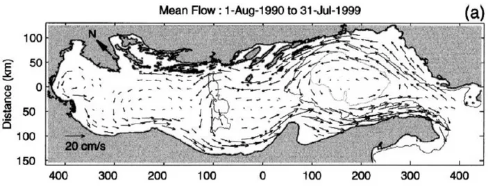
Fig. 2.2. Surface water circulation in the Adriatic Sea. From Poulain (2001).
Otherwise, from the south the Modified Atlantic Waters and Levantine Intermediate Waters (respectively MAW and LIW) reach the Adriatic basin through the Otranto Strait (Orlic et al., 1992). The Southern Adriatic consequently represents the site of convergence of two distinct water masses, the North Adriatic Dense Water and the LIW, and is a site of production of dense waters (Civitarese et al., 2005). In fact, winter convection and dense water formation take place in the centre of the SAP, at 1200 m water depth, as a result of outbreaks of cold continental air from the Balkan Peninsula, which takes heat from the sea surface layer through cooling and evaporation, and causes movement
30
through the water column in the centre of a gyre that rotates counter-clockwise (Poulain 2001). The Montenegro-Albanian shelf and slope is a peculiar sector of the Adriatic Sea circulation, and can be identified as a ROFI (Region of Freshwater Influence) mainly because of the presence of several rivers and abundant precipitations enhanced by the presence of high mountain ranges (Bellafiore et al. 2011). This area is mainly supplied by the Buna-Bojana River (Fig. 1.1) and by several minor streams including the Drini, Mati, Ishimi, Erzeni, Shkumbini, Semani and Vjosa Rivers. The Buna-Bojana River in the SE Adriatic represents the counterpart of the Po River and has the largest single discharge (about 700 m3 s-1); the combined discharge of the Albanian rivers amount to
about 1250 m3 s-1 (UNEP 1996; Table 1). Several of the coastal plumes from the Albanian and
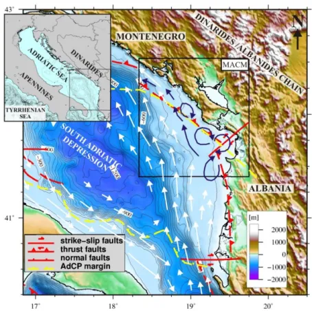
Montenegro rivers can be readily identified by chlorophyll images, but the largest chlorophyll feature is off the Buna/Bojana delta (Marini et al. 2010). The northward turning of the river plume is consistent with the Coriolis effect (Kourafalou, 1999) and it is also in the direction of prevailing southeastern Adriatic currents (Artegiani et al., 1997). According to Manca et al. (2002), the cyclonic circulation transports relatively fresh water along the western boundary trough the southward density-driven WACC. The South Eastern Adriatic current (SEAd; Marini et al. 2010) transports Ionian Surface Water (ISW) along the eastern boundary northward into the Adriatic Sea. The Buna-Bojana plume is deflected northward by the Coriolis apparent force, independently from the dominant local southward wind forcing that should result in southward currents and localized upwelling (Marini et al. 2010). Marini et al. (2010) describe what they call the South Eastern Shelf Coastal Current (SESC), which characterizes the oceanographic regime of this region (Fig. 2.3). According to this work, the SESC detaches from the coast in correspondence with the Buna/Bojana outflow and forms coastal eddies that expand the offshore extent of the river plumes. This results in a local complexity in the water circulation.
2.2 Geodynamic and structural setting of the MACM
The Adriatic region includes the relatively stable Adriatic Basin (Po Valley, Adriatic Sea and Apulian foreland), surrounded on the eastern, northern and western margins by the Albanides/Dinarides, the Alps, and the Apennines, respectively (Fig. 1.1). Geodynamic reconstructions of the Adriatic Basin document its evolution from a Mesozoic passive margin to the Cenozoic foreland of the Apenninic and Dinaric thrust belts (D’Argenio and Horvath, 1984; Royden, Patacca and Scandone, 1987) dominated by collisional processes between the African and Eurasian plates (Geiss, 1987).
31
Fig.2.3. Mean horizontal surface distribution of modeled currents at 2m, showing the SESC in the MACM. Modified from Marini et al. (2010).
The growth of structural highs east of the Gargano Promontory (i.e., the NW-SE oriented Gallignani and Pelagosa ridges, and the SW-NE oriented Tremiti structural high) started in the Late Pliocene and resulted in the segmentation of the foredeep into two separate basins: the Adriatic foredeep basin, north of the Gargano promontory, and the Bradanic foredeep to the south (Casnedi, 1988; Capuano et al., 1996). In this complex geodynamic setting, the presence of the Adria Microplate has been proposed since the earliest studies of this area (Finetti, 1984). Focal mechanisms and epicenter alignments of historical and recent earthquakes, as well as geodetic observations, show NE-SW extension along normal faults crossing the Apennines, N-S convergence across the Alps, as well as strike-slip and thrust fault deformation resulting in NE-SW shortening along the eastern coast of the Adriatic Sea, i.e., the Dinaric and Albanian chains (Anderson and Jackson, 1987; Pondrelli et al., 2002; Hunstad et al., 2003).
32
Nocquet and Calais (2003), showing that the Adriatic microplate moves NE at a rate of 4-5 mm/yr relative to Eurasia, Battaglia et al (2004) observed that the existence of Adria offers a better fit to GPS velocity models. The southeastern boundary of Adria is located along the Dinarides/Albanides mountain chains (Fig. 2.4), a SW verging fold-and-thrusts belt formed starting from the Eocene (Rosenbaum and Lister, 2005), that represent the extension towards SE of the Alps.
The Dinarides/Albanides chain shows two different tectonic domains and associated strain regimes: an outer compressional belt, which encompasses the continental shelf and slope; and an inner domain located onshore. The latter is characterized by extensional deformation (Aliaj, 1997) and by alternating ridges and troughs, that form due to incipient extensional deformation along a Plio-Quaternary normal fault system, oriented NW-SE. Conversely, the outer domain, that constitutes the present-day collisional front, shows a compressional regime affecting the entire sedimentary sequence (Aliaj, 1997); this sector of the margin corresponds the MACM, our working area.
Fig.2.4. Geographical framework of the southeastern Adria Microplate and of the MACM. Segmentation of the SE boundary of Adria Microplate are formed by the LU is Lezha-Ulqini segment and FD is Frakulla-Durresi segment, these are takenfrom Aliaj 2000. Topography and bathimetry is from GEBCO.
33 Doglioni et al. (1999) show that the Adriatic continental lithosphere is subducting below the Dinarides-Hellenides along a shallow NE-dipping plane, representing an eastward subduction of continental lithosphere as the final stage of an oceanic subduction followed by incipient continental collision; this process produced a double-verging Alpine-type orogenic prisms characterized by high structural and topographic relief (Fig. 2.5).
Fig.2.5. Schematic model for continent-continent collision. Modified from Willett et al., 1993
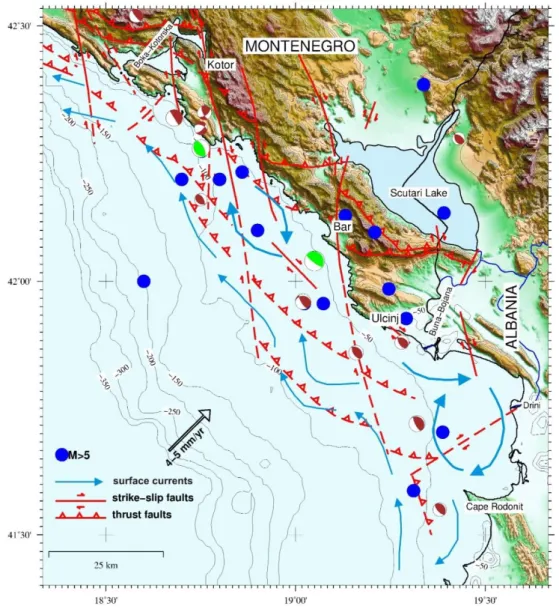
The tectonic features of this convergent system, over which the Dinaride thrusts develop was analysed through the study of a closely spaced grid of multichannel seismic lines, collected during the ’80 and the ’90 by oil companies. However, these data are still mostly unpublished, if we exclude few line-drawings interpretations in Dragasevic (1974, 1983) and Aliaj (1998, 2000). Using these data, Aliaj (1998, 2000) noted that the accretionary front is displaced by a series of right-lateral transfer faults (Fig. 2.6). The most prominent of these fault systems are, from S to N: the Sazani Island (or Vlora-Tepelena), and the Gjiri Drinit-Lezha (or Shkodra-Peja, or Scutari-Pec, Fig. 2.4). These strike-slip faults separate the MACM in distinct segments, with a diachronous evolution (Aliaj 1998, 2000).
34
fault shows a WNW orientation and an extent of over 200 kms, from Lezhatown (Albania) to the Montenegro margin along the Adriatic coast. This segment has been described as part of the Kruja zone (Aliaj, 1998; Dragasevic, 1983). In this area, the thrust front is buried below a thick sedimentary sequence, affected by compressive faulting up to the lower Pliocene which appear overprinted by more recent E-NE strike-slip deformations.
Fig. 2.6. Simplified structural map of the Montenegro/Albanian margin. Location of main structural features is from Oluic et al., (1982), Aliaj et al. (2004) and Aliaj (2008). Epicenters of M>5 earthquakes (blue circles) are indicated (ANSS 1963-2009 http://www.quake.geo.berkeley.edu/anss/catalog-search.html), as well as focal mechanism of major recent events (Pondrelli et al., 2006). Surface currents pattern (SESC) is from Marini et al. 2010. Adriatic plate NE convergence vector (fixed Eurasia) is from Grenerczy et al. (2005).
35 2. The FRAKULLA-DURRESI segment (Fig. 2.4) is about 130 km long and shows a N-NNW orientation. It is located in the peri-Adriatic depression propagating from Lezhato Vloratowns and constitutes the outermost lineament of post-Pliocene oblique compressive faults, cut by strike-slip E-NE oriented segments.
On a more local scale, Oluic et al., (1982), based on Dragasevic (1974), shows that the overall setting of the 200 km-long MACM is controlled by two first-order tectonic systems: a thrust-belt chain verging towards ENE; a wrench tectonic system displacing the front into several blocks, consisting of right-lateral strike slip faults whose orientation rotates from N-S in the northern part, to NE-SW towards south (Fig. 2.6).
Being part of the seismically active Dinarides/Albanides fold-and-thrust belt (Aliaj, 1999; 2000), the MACM is characterized by an intense seismic activity, as highlighted by the distribution of M>5 epicenters recorded during the last 50 years (Fig. 2.6). In fact, it is one of the Central Mediterranean coastal areas more prone to seismic hazards, and has been site of large historical earthquakes in the near past, such as, the M=7, Dubrovnik event of April 6 1667, the M=6.5, June 13, 1593, event, with epicenter close to Kotor, and the destructive June 1, 1905 event, close to Skadar. The recentmost large magnitude (Mw 7.1) earthquake occurred by April 15, 1979 offshore Montenegro, between Bar and Ulcinj (Fig. 2.6); the main shock of this event occurred along a shallow (7 km deep), low angle (14°) thrust fault, parallel to the coastline and dipping toward NE (Benetatos et al., 2006).
36
References
Aliaj, S. 1997 - Alpine geological evolution of Albania. Albanian Journal of Natural & Technical Sciences, No 3, 69-81
Aliaj, S. 1998 - Neotectonic structure of Albania. Albanian Journal of Natural & Technical Sciences, No 4, 79-97.
Aliaj, S. 1999 - Transverse faults in Albanian orogen front. Albanian Journal of Natural &Technical Sciences, No 6, 121-132.
Aliaj, S. 2000 - Thrust front along Adriatic collision and seismic potential of its seismogenic nearby zone. Proc. International Symposium on Earthquake Engineering (ISEE), Montenegro, 85-93
Anderson H. & Jackson J. 1987 – Active tectonics of the Adriatic region. Geophys. J. R. astr. Soc., 91,937-983
ANSS (Advanced National Seismic System) – Northern California Earthquake Data Center –
www.ncedc.org/anss
Artegiani, A., Bregant, D., Paschini, E., Pinardi, N., Raicich, F., Russo , A., 1997. The Adriatic Sea general circulation. Part I,. Air-sea interactions and water mass structure. Journal of Physical Oceanography 27, 1492-1514.
Battaglia, M., Murray, M.H., Serpelloni, E., and Bürgmann, R., 2004, The Adriatic region: An independent microplate within the Africa-Eurasia collision zone: Geophysical Research Letters, v. 31 doi: 10.1029/2004GL019723.
Bellafiore, D., Guarnieri, A., Grilli, F., Penna, P., Bortoluzzi, G., Giglio, F., & Pinardi, N. (2011). Study of the hydrodynamical processes in the Boka Kotorska Bay with a finite element model. Dynamics of Atmospheres and Oceans, 52(1-2), 298–321. doi:10.1016/j.dynatmoce.2011.03.005
Benetatos C. and Kiratzi A., 2006. – Finite-fault slip models for the 15 April 1979 (Mw 7.1) Montenegro earthquake and its strongest aftershock of 24 May 1979 (Mw 6.2). - Tectonophysics 421, 129-143. Capuano 1996
Casnedi R. 1988. La fossa Bradanica: origine, sedimentazione e migrazione. Mem. Soc. Geol. It., 41,439-448 Civitarese G., Gacic M., Cardin V., Ibello V., 2005 - Winter convection continues in the warming Southern
Adriatic. Eos, 86: 445-451.
D'Argenio B., and Horvath F.1984 - Some remarks on the deformation history of Adria, from the Mesozoic to the Tertiary. Annales Geophysicae 1984; 2: 143-146
Doglioni, C., Harabaglia, P., Merlini, S., Mongelli, F., Peccerillo, a, & Piromallo, C. (1999). Orogens and slabs vs. their direction of subduction. Earth-Science Reviews, 45(3-4), 167–208. doi:10.1016/S0012-8252(98)00045-2
Dragasevic, T. 1974. Recent structure of Earth's Crust an Upper Mantle in Yugoslavia. – Zbornik: Metalogenija i koncepcije geotektonskog razvoja Jugoslavije (Collection: Metallogeny and Concepts of Geotectonic History of Yugoslavia). Faculty of Mining and Geology, Belgrade, 59-72 (in Serbian). Dragasevic T. 1983 – Oil geologic exploration in the Montenegro offshore in Jugoslavia. – NAFTA, 34:
37 Fernandes, R. M. S., B. A. C. Ambrosius, R. Noomen, L. Bastos, M. J. R. Wortel,W. Spakman, and R.
Govers (2003), The relative motion between Africa and Eurasia as derived from ITRF2000 and GPS data, Geophys. Res. Lett., 30(16), 1828, doi:10.1029/2003GL017089
Finetti, I., 1984. Struttura ed evoluzione della Microplacca Adriatica. Bollettino di Oceanologia Teorica ed Applicata, II, 115-123.
Grenerczy, G., Sella, G., Stein, S., Kenyeres, A., 2005. Tectonic implications of the GPS velocity field in the northernAdriatic region. Geophysical Research Letters, v. 32.
Geiss, E. 1987 - A New Compilation of Crustal Thickness in the Mediterranean Area, Ann. Geophys.5B(6), 623–630.
Hunstad, I., Selvaggi, G., D’agostino, N., England, P., Clarke, P. and Pierozzi, M. 2003: Geodetic strain in peninsular Italy between 1875 and 2001. Geophys. Res. Lett., 30: 1181. doi:10.1029/2002GL016447. Kourafalou, V.H., 1999. Process studies on the Po River plume, north Adriatic sea. Journal of Geophysical
Research 104 (C12), 29963 - 29985.
Marini, M., Grilli, F., Guarnieri, A., Jones, B. H., Klajic, Z., Pinardi, N., & Sanxhaku, M. (2010). Is the southeastern Adriatic Sea coastal strip an eutrophic area? Estuarine, Coastal and Shelf Science, 88(3), 395–406. doi:10.1016/j.ecss.2010.04.020
Manca, B.B., V. Kovacevic, M. Gacic and D. Viezzoli (2002), Dense water formation in the Southern Adriatic Sea and interaction with the Ionian Sea in the period 1997–1999, Journal of Mar. Syst., 33-34, 133-154. Miserocchi, S., Langone, L., Tesi, T., 2007. Content and isotopic composition of organic carbon within a flood
layer in the Po River prodelta (Adriatic Sea). Continental Shelf Research 27, 338–358. McClusky 2000-2003
Nocquet, J. M., and E. Calais 2003 - Crustal velocity field of western Europe from permanent GPS array solutions, 1996–2001, Geophys. J. Int., 154, 72–88
Oluic M., Cvijanovic D., and Prelogovic E. 1982. - Some new data on the tectonic activity in the Montenegro coastal region (Yugoslavia) based on the landsat imagery. - Acta Astronautica v 9, No.1, 27-33. Orlic, M., Gacic, M., La Violette, P.E., 1992. The currents and circulation of the Adriatic Sea. Oceanologica
Acta 15, 109–124.
Pondrelli, S., A. Morelli, G. Ekström, S. Mazza, E. Boschi, and A. M. Dziewonski, 2002. European- Mediterranean regional centroid-moment tensors: 1997-2000, Phys. Earth Planet. Int., 130, 71-101 Pondrelli S., Salimbeni S., Ekstrom G., Morelli A., Gasperini P. and Vannucci G. 2006. - The Italian CMT
dataset from 1977 to the present. - Phys. Earth Planet. Int., doi:10.1016 / j.pepi. 2006.07.008, 159/3-4, pp. 286-303.
Poulain P.M. 2001. Adriatic Sea surface circulation as derived from drifter data between 1990 and 1999. Journal of Marine Systems, 29: 3-32.
Piva, A 2007 - High-resolution stratigraphy of Central and Southern Adriatic Quaternary deposits of
sub-Milankovian climate change on Mediterranean circulation – PhD Thesis – University of Bologna
Ridente, D., Trincardi, F., 2006. Propagation of shallow folds and faults in late Pleistocene and Holocene shelf-slope deposits, central and South Adriatic Margin (Italy). Bas. Res. 18, 171–188
Ridente, D., F. Foglini, D. Minisini, F. Trincardi and G. Verdicchio 2007 - Shelf-edge erosion sediment failure and inception of Bari Canyon on the South-Western Adriatic Margin (Central Mediterranean), Marine Geology, 246, 193-207.
38
Rosenbaum, G., and Lister, G.S., 2005, The western Alps from the Jurassic to Oligocene: Spatio-temporal constraints and evolutionary reconstructions: Earth-Science Reviews, v. 69 pp. 281-306 doi: 10.1016/j.earscirev.2004.10.001.
Royden L., Patacca E. and Scandone P. 1987. - Segmentation and configuration of subducted lithosphere in Italy: An important control on thrust-belt and foredeep-basin evolution. Geology,15,714-717
Syvitski, J.P.M. & Kettner, A.J. (2007): On the flux of water and sediment into the Northern Adriatic. Continental Shelf Research (27): 296-308.
UNEP 1996. Mediterranean Action Plan (MAP), Implications of Climate Change for the Albanian Coast, Technical Reports series No.98.
Verdicchio G, Trincardi F, Asioli A (2007) Mediterranean bottom- current deposits: an example from the Southwestern Adriatic Margin. Geol Soc Lond Spec Publ 276:199–224
Willett, S., Beaumont, C., and Fullsack, P., (1993), Mechanical model for the tectonics of doubly vergent compressional orogens: Geology, v. 21, p. 371–374
39