PARTE II
UN RITORNO POSSIBILE. STRATEGIE, PROPOSTE E PROSPETTIVE
PER IL RILANCIO DEI CENTRI ABBANDONATI
PART II
A POSSIBLE RETURN. STRATEGIES, PROPOSALS AND PERSPECTIVES
FOR THE RE-LAUNCH OF ABANDONED SMALL TOWNS
ArcHistoR EXTRA 7 (2020)
o n e n e e d s a t o w n
Supplemento di ArcHistoR 13/2020Studies and perspectives for abandoned or depopulated small towns
ISSN 2384-8898
www.archistor.unirc.it 2.1 STRATEGIES AND PERSPECTIVES fOR ThE
Re-launch of abandoned Small TownS 2.1 STRATEGIE E PROSPETTIVE PER IL RILANCIO DEI CENTRI ABBANDONATI
Policies and Rules for the Repopulation of Abandoned Small Towns. Some Reflections
Renata Prescia (Università degli Studi di Palermo)
DOI: 10.14633/AHR249 ISBN 978-88-85479-09-8
Politiche e disposizioni per il ripopolamento dei
piccoli centri abbandonati. Alcune riflessioni
Renata Prescia
Lo spopolamento è oggi un fenomeno planetario, reso ancor più complesso dalle dinamiche di mobilità globali di cui sono protagoniste intere comunità migranti, che tentano di spostarsi da condizioni climatiche, lavorative, di pace sociale meno favorevoli, verso altre più favorevoli o, almeno, ritenute tali. Tali mobilità innescano un processo a catena (con effetto domino) che rischia di sconvolgere le tradizionali reti di appartenenza e che, in taluni casi, può indurre ad analoghi processi “di ritorno”; diventa allora importante contrastare, al fine anche di mantenere equilibri demografici e geografici, tali fenomeni con una metodica inversa, favorendo cioè la “restanza” con ogni possibile azione, garantendo le connessioni che, seppur digitali, devono avere sempre al centro l’uomo1.
Il complesso fenomeno può essere determinato da svariate cause: la loro comprensione è il primo, indispensabile passo per la messa a punto di strategie corrette.
Il contributo di Lucina Napoleone chiarisce che in Liguria le cause dell’abbandono sono sostanzialmente di due tipi: l’insorgenza di eventi naturali e l’impetuoso sviluppo delle città costiere, che hanno causato un vero e proprio abbandono dei territori più fragili sull’Appennino genovese. Per essi, classificati come “zone depresse”, le autorità di governo hanno individuato lo sviluppo turistico come volano per la rigenerazione. da queste premesse, l’autrice svolge una meditata riflessione sul mutamento che ciò induce nel patrimonio culturale, trasformato in “merce” da brandizzare per poter essere riconosciuto, coinvolgendo, nei borghi, ogni componente materiale e ogni attività: artigianato,
898
feste, edifici, eccetera. Questa prima modificazione innesca un ulteriore processo trasformativo, che vede il patrimonio tramutarsi in “mezzo di produzione”, con una progressiva de-materializzazione del bene e, soprattutto, con un’acquisizione di valore in termini monetari. Quest’ultima, a sua volta, incentiva nel proprietario, sia esso privato o ente pubblico, una volontà/desiderio di ritorno economico, la cui progressione è inversamente proporzionale alla conservazione del bene. I limiti di tale processo potrebbero essere fissati solo da un attore terzo che, in genere, si è riconosciuto nello Stato, ma che oggi non riveste più tale ruolo, se solo si riguarda a due dei principali programmi del governo (miBACT): il Piano strategico di sviluppo del Turismo 2017-222 e la Carta Nazionale del paesaggio del 2018, che sottolineano fortemente e, quasi univocamente, le finalità turistiche, sia
pure per alleggerire un’accentuata pressione sulle cosiddette città d’arte.
a questi si potrebbero aggiungere le celebrazioni annuali dei “borghi italiani” e l’ultimo bando miBACT Interventi finalizzati alla riqualificazione e valorizzazione turistico-culturale delle regioni
Basilicata, Campania, Calabria, Puglia, Sicilia (2020)3: in realtà, la finalità turistica non è sicuramente
sempre un beneficio per il patrimonio culturale, ma, soprattutto, non è una scelta vincente ai fini del rafforzamento delle comunità residenti.
antonella mamì finalizza il suo contributo pragmatico, denso di ascolto pedagogico attraverso gli strumenti della formazione, a illustrare possibili azioni di contrasto a questa logica turistica imperante sul diverso territorio della Sicilia, dove le cittadine costiere hanno avuto lo stesso impetuoso sviluppo della liguria, anche se con esiti meno qualitativi, a causa dell’abusivismo. nell’isola, però, data la diversa configurazione geografica e orografica, le aree interne sono più numerose e, soprattutto, connotate da una storia basata sulla cultura agraria che in talune fasi – età romana, età seicentesca – è stata determinante per lo sviluppo e la riconoscibilità dell’isola. Questa è la dimensione che è necessario ri-meditare con mentalità innovativa, ponendo fine alla fiducia incondizionata nel falso mito del progresso industriale e dello sviluppo illimitato delle grandi città che ha caratterizzato il novecento. a questo recupero si dedica l’attività didattica e di ricerca dell’autrice4 che tenta di riscrivere, con visione smart, la gestione dei cicli
dell’acqua, di materia RSu, della produzione dell’energia, della domotica per una sanità in rete, del recupero rurale e del recupero edilizio con un misurato occhio al turismo. In ogni caso, al turismo, selezionato, delle passeggiate e degli itinerari naturalistici, così come evidenziati nella recente legge 158/20175.
2. www.beniculturali.it/documents/1481892223634_PST_2017_IT
3. decreto 69 del 21.2.20 (Gazzetta ufficiale V serie speciale – contratti pubblici n. 24 del 28.2.20). 4. campisi, mamì, Prescia 2013.
5. legge 158 del 6.10.1917, misure per il sostegno e la valorizzazione dei piccoli comuni, nonchè disposizioni per la riqualificazione e il recupero dei centri storici dei medesimi comuni (in corsivo)(G.u. n. 256 del 2.11.1917).
Politiche e disposizioni
lo stesso approccio integrato tra varie azioni è auspicato dal saggio di Gabriella Pultrone che ritiene che queste “periferie interne”, il cui abbandono è determinato innanzitutto da scarsa accessibilità e carenza di servizi, possano al converso «assumere una funzione strategica nei processi di sviluppo regionale in un’ottica di policentrismo territoriale, di rapporto equilibrato tra città e aree interne, all’interno di ambiti strategici d’intervento trasversali». In particolare l’autrice riporta l’esperienza in
progress di una regione del territorio iberico, la Serrania celtiberica che comprende aragona, castilla
la mancha, castilla y leon, Generalitat valenciana e la Riojazha che, avendo meno di 8 abitanti/ kmq è la seconda area più spopolata nel contesto europeo. Per questo motivo è stata oggetto di appositi sostegni istituzionali, nel 2015 e nel 2017, attraverso l’elaborazione della Ruta Celtiberica come itinerario culturale europeo, con la consulenza delle università della Regione.
In parallelo, il saggio evidenzia le potenzialità della apposita strategia SNAI avviata in Italia nel 2012 dal ministro per la coesione territoriale, riportando la positiva esperienza dell’area Interna Valchiavenna, in provincia di Sondrio, che ha deciso di caratterizzare il turismo nella sua dimensione sportiva proponendo una palestra diffusa a cielo aperto per tutti.
La SNAI è nuovamente al centro del contributo di Stefano Aragonache ne apprezza lo sforzo di portare avanti delle politiche integrate, così come sono andate maturando dopo la convenzione europea del paesaggio (2000) e la carta di lipsia (2007) in cui, espressamente, l’ue ha sottolineato la necessità di strategie integrate tra aree rurali e urbane o metropolitane. La SNAI, a cui in corsa si è aggiunto il formez, sta per ora monitorando e supportando l’andamento dei processi di gestione integrata tra i comuni, al fine di valutare il livello di associazionismo in atto, identificando le “buone pratiche”. a essa si integra positivamente la già citata l. 158/2017, che prevede una serie di misure per la riqualificazione dei piccoli comuni come quelle per l’accesso a banda larga e internet, assieme al rafforzamento dei servizi pubblici essenziali. d’altronde questi piccoli centri, se dotati di servizi, possono divenire sempre più spesso un’alternativa alla concentrazione demografica in luoghi sempre più invivibili. ancora in parallelo l’autore registra iniziative “fai da te”, come l’ecomuseo delle ferriere e fonderie della calabria nella Valle dello Stilaro o il muSaba – Parco museo laboratorio di Santa barbara nella provincia di Reggio Calabria, che si occupa di arte, scienza, agricoltura biologica, eccetera.
Il contributo di Sante foresta, confermando l’impegno dell’Università di Reggio Calabria sul tema dei centri abbandonati6, in quanto caratteristica identitaria della regione, racconta di una positiva
pianificazione posta in essere con il PSa, voluto dall’associazione dei comuni di caccuri, castelsilano, cerenzia e Savelli, data la omogeneità delle loro caratteristiche territoriali e storico-culturali inveratesi
900
fin dal 1930 come marchesato di crotone. Il PSa, costruito in relazione alla pianificazione regionale7,
è diretto al coordinamento e al raccordo tra tutti gli attori della programmazione comunale, regionale e provinciale e vuole caratterizzarsi come strumento strategico di supporto allo sviluppo socio-economico e territoriale. nella sua elaborazione una particolare attenzione è stata dedicata ai processi finalizzati alla definizione di strategie, strumenti e azioni per la gestione integrata dei sistemi urbani e territoriali, che caratterizzano la configurazione del sistema paesaggistico-ambientale, assicurando la tutela e la valorizzazione della cultura dei nuclei urbani dell’area in oggetto. la dotazione dei servizi necessari, il potenziamento delle infrastrutture, gli eventuali ampliamenti urbani dovranno rispettare l’identità di essi e, in special modo la presenza di fasce collinare e montane che si estendono a ridosso dei nuclei urbani, uno degli aspetti più preziosi dei quattro comuni. Questo tratto, che potrà anche essere potenziato, fa di questi borghi degli originali esempi di ottime relazioni tra città e campagna, tra cultura urbana e cultura agraria, che costituisce uno degli obiettivi di tutti i contributi per riequilibrare il modello pan-urbano fin qui coltivato. una proposta questa del PSa tutta interna alla cultura urbanistica che, ci auguriamo, possa trovare una applicazione all’interno della SnaI.
dalla lettura di questi interessanti contributi si determina:
1. la necessità di porre in essere una preminente azione formativo-pedagogica che, rivolgendosi alla politica e alla comunità, riesca a esprimere la capacità di far vedere a entrambe le prospettive di un problema da trasformare in risorsa;
a tale obiettivo sarebbero naturalmente deputate le università, ove le contestate leggi berlinguer e Gelmini, e la nuova Rivoluzione digitale, hanno comunque indotto un processo di rinnovamento che comincia a mostrare anche dei segnali positivi, quale per esempio la “Terza missione”, che consente di lavorare sul territorio, fuori dalle confortanti aule accademiche, e che va configurando una “terra di mezzo”8. L’Università è in grado di assicurare competenze, senso di comunità, sviluppo,
svincolandosi una volta per tutte dalle accuse di “accademismo” e sprigionando invece le sue caratteristiche di “rendimento sociale”9, attraverso l’istituzione di servizi di educazione permanente
orientati allo sviluppo di competenze e identità culturali. È pertanto da rafforzare la produzione di laboratori formativi, luoghi di riunione olistica, che attuino processi di sperimentazione o di ricerca/
azione in cui gli abitanti possano essere agenti dei processi di trasformazione, e in cui diviene centrale
«l’educazione da intendere non come settore a parte ma come condizione abilitante di un paese»10, 7. legge Regionale n. 19 del 16 aprile 2002, art. 13.
8. Rossi doria 2019. 9. carta 2018.
Politiche e disposizioni
in forza di nuovi rapporti di istruzione/apprendimento che riconoscano il potenziale educativo dei contesti, da parte dei formatori e delle comunità11. Spiace constatare che nei “centri multifunzionali”
previsti dalla legge 158/2017 (articolo 2, comma 2) non siano contemplate le università che, da tempo, conducono esperienze didattiche integrate col territorio, come peraltro qui rappresentate12.
Vere e proprie
«officine in cui maturare nuove proiezioni progettuali da offrire alle Pubbliche amministrazioni, le quali, è bene rimarcarlo, spesso non sono adeguatamente consapevoli dei vantaggi che potrebbero trarre da simili collaborazioni, e che troppo spesso restano ancorate a proposte dominate da vincoli normativi ed economici, nonché da tecnicismi, perdendo tutti quei valori che un progetto colto e creativo dovrebbe possedere»13.
2. la necessità di impiegare competenze realmente multidisciplinari nelle azioni di pianificazione urbanistica e progettazione da condurre con strategie mirate e incisive, innestate sul know how della conservazione, che si occupa di Patrimonio culturale anche nell’accezione più innovativa data dalla convenzione di faro come “eredità”, offrendo un contributo al non estraniamento dei beni in quanto carta d’identità della comunità. alla complessa macchina burocratica posta in essere con la SnaI si evidenzia, come è già stato notato14, che manca completamente un’interrelazione con l’ambito della
conservazione che, negli ultimi anni, ha messo a punto tanti documenti operativi sulla conoscenza del costruito storico, strutturati come linee Guida15 o come specifici programmi materico-costruttivi 16.
Il territorio, i beni culturali e le comunità d’apprendimento diventano una sfida pedagogica nella definizione di un modello di fruizione del patrimonio per la promozione dei contesti locali, a cui potrebbero concorrere: associazioni e imprese culturali che si assumono l’onere di gestire parti del patrimonio, piattaforme che sviluppano risorse digitali per la narrazione di beni culturali17, gli
eco-11. carta IcomoS per l’interpretazione e la presentazione dei siti del patrimonio culturale, detta carta di ename , ratificata nella 16 assemblea generale dell’IcomoS, Québec (canada) il 4 ottobre 2008. www.Icomos.org (ultimo accesso 20 aprile 2020)
12. Vedi anche, con riferimento all’ambito della conservazione, gli atti del I e II convegno nazionale SIRa. www.sira.it. 13. Giannattasio 2020, p. 396.
14. oteri 2019.
15. linee Guida per l’abbattimento delle barriere architettoniche (2008), per la riduzione del rischio sismico (2011), per l’efficentamento energetico (2011).
16. Vedi Progetto meTRics, Metodologie e tecnologie per la gestione e riqualificazione dei centri storici e degli edifici di pregio (Picone, Russo 2017) o la ricerca su Tecniche murarie tradizionali: conoscenza per la conservazione e il miglioramento prestazionale sullo specifico patrimonio delle torri costiere (Giannattasio, Grillo, murru 2017).
902
musei quali «pratiche partecipate di valorizzazione del patrimonio culturale materiale e immateriale, elaborata e sviluppata da un soggetto organizzato, espressione di una comunità locale, nella prospettiva dello sviluppo sostenibile»18 eccetera.
una guida a quanti sono coinvolti in interventi di conservazione e gestione del patrimonio culturale è stata recentemente proposta dagli European Quality Principles (2019) messi a punto dal Consiglio d’Europa19.
I nuovi protagonisti delle ricerche sono oggi i paesaggi 20 e i patrimoni rurali21 su cui dibattono i più
aggiornati documenti internazionali quali le Cultural routes (Icomos 2008) 22, il Rural landscape and beyond (Icomos-Ifla 2019)23 e i principali assi di finanziamento (horizon 2020).
Per dare delle risposte al tema dello spopolamento e degli abbandoni24 è indispensabile progettare
azioni di ripopolamento dei territori abbandonati, connessi da nuove dotazioni infrastrutturali, fisiche e digitali, creando nuove “prossimità”25. Questo nuovo concetto che nasce dalla consapevolezza di
un bisogno condiviso tra più persone, accomunate generalmente dalla vicinanza territoriale, ma anche dalla disposizione a sentire come propri i problemi di chi è accanto, ha incentivato già in ambiti urbani realtà positive come il co-housing, gli orti urbani, i supermercati solidali. Il suffisso ri- (riuso, rigenerazione, riciclo) lascia velocemente spazio al suffisso (progettazione, co-evolutivo, co-creativo) che meglio sta a ribadire la compartecipazione in azioni complesse, quali sono quelle che, indubbiamente, stiamo trattando. Progettare per reti chiama inevitabilmente in causa le infrastrutturazioni digitali che dobbiamo imparare a governare perché indispensabili per assicurare le connessioni e per garantire un processo sostenibile, specie per quanto riguarda le risorse ambientali (per esempio “smart grid”).
18. Reina 2014. le diverse realtà, costituitesi secondo leggi regionali, dal 2017 hanno creato una rete e una piattaforma DROPS in cui è stata presentata la richiesta di una legge nazionale sul tema.
19. openarchive.icomos.org/2083/1/european Quality Principles (ultimo accesso 20 aprile 2020) 20. miBACT 2017.
21. Vedi per esempio Strategic plan National rural revitalization China’s 2018; oppure il progetto RuRITaGe (horizon 2020). 22. cIIc (International Scientific committee on cultural Routes), The ICOMOS charter on cultural routes, ratificata dalla 16° assemblea Generale IcomoS (Québec/canada, 4 ottobre 2008).
23. www.Icomos.org (ultimo accesso 20 aprile 2020). 24. Teti 2018.
25. Sono prevalentemente azioni dal basso, che si confrontano in una biennale della prossimità (Genova 2015, bologna 2017, Taranto 2019). www.fondazioneconilsud.it.
Politiche e disposizioni
Bibliografia
bonacini 2018 - E. bonacini, Partecipazione e co-creazione di valore culturale, iziTRAVELSicilia e i principi della Convenzione di Faro, in «Il capitale culturale», 2018, 17, pp. 227-273, https://riviste.unimc.it/index.php/cap-cult/article/view/ (ultimo accesso 20 aprile 2020).
campisi, mamì, Prescia 2013 - m.T. campisi, a. mamì, R. Prescia, Neighborhoods in Bucharest. Recognition, conservation and inheritance, in R.crisan, G.franco, l.Kealy, S.f.musso (a cura di), Transaction on architectural education, EAAE, Leuven (belgio) 2012, pp. 205-228.
carta 2018 - m. carta, Università, le tre sfide per il futuro, in «Repubblica», 26 ottobre 2018.
dominici 2019 - P. dominici, Prospettive etiche per un nuovo ecosistema della comunicazione, francoangeli, milano 2019. Giannattasio, Grillo, murru 2017 - c. Giannattasio, S.m. Grillo, S. murru, Il sistema di torri costiere in Sardegna. Storia della tecnica edilizia e restauro dei monumenti, l’erma di bretschneider, Roma 2017.
Giannattasio 2020 - c. Giannattasio, Per una libertà di pensiero. Rapporti tra Università e Committenza nel restauro del patrimonio architettonico, in E. coisson, c. Giannattasio, m.a. Giusti (a cura di), Committenze e patrimonio, Sezione 3.1. in S.f. musso, m. Pretelli (a cura di), Restauro Conoscenza Progetto Cantiere Gestione, atti del II convegno SIRa (bologna, 21-22 settembre 2018), Quasar, Roma 2020, pp. 394-401.
menozzi, maniaci, 1992 - l. menozzi, a. maniaci (a cura di), Le rovine nell’immagine del territorio calabrese, Gangemi, Roma 1992.
mibact 2017 - mibact, Stati generali del paesaggio, Gangemi, Roma 2017, https://www.beniculturali.it/mibac/multimedia/ mibac/documents/1520941876714_3588-3_mIbacT_Stati_generali_del_paesaggio_-_aTTI.pdf (ultimo accesso 20 aprile 2020).
mollica 1998 - E. mollica, Calabria: “area interna”, in l. Viganoni (a cura di), Temi e problemi di geografia, Gangemi, Roma 1998, pp. 153-170.
oteri 2019 - a.m. oteri, Architetture in territori fragili. Criticità e nuove prospettive per la cura del patrimonio costruito, in «archistoR», VI (2019), 11, pp. 169-205.
Picone, Russo 2017 - R. Picone, V. Russo, L’arte del costruire in Campania tra restauro e sicurezza strutturale, Clean, Napoli 2017.
Reina 2014 - G. Reina (a cura di), Gli ecomusei. Una risorsa per il futuro, marsilio, Venezia 2014.
Teti 2018 - V. Teti, Riabitare i paesi. Un “manifesto” per i borghi in abbandono e in via di spopolamento, in «Il corriere della calabria», 30 settembre 2018.
ArcHistoR EXTRA 7 (2020)
www.archistor.unirc.it ISSN 2384-8898
Supplemento di ArcHistoR 13/2020
a cura di Annunziata Maria Oteri Giuseppina Scamardì
u n pa e s e c i v u o l e
Studi e prospettive per i centri abbandonati e in via di spopolamento
o n e n e e d s a t o w n
S t u d i e s a n d p e r s p e c t i v e s f o r a b a n d o n e d o r d e p o p u l a t e d s m a l l t o w n s
ISBN 978-88-85479-09-8
Lo scritto evidenzia come i piccoli e piccolissimi centri, pari al 69,9% dei Comuni italiani, il tessuto connettivo del “Paese delle 100 Campanili” costruito in millenni, soffrono processi di abbandono. Politiche dissenate di tagli nei collegamenti assieme a quelle di privatizzazione e
liberalizzazione sono tra le principali responsabili del venir meno dei caposaldi storici del territorio. Mentre i poli principali stanno giovandosi di alta velocità e finanziamenti speciali con Agenda Urbana UE. Per ribaltare tale situazione, avendo come riferimento la Carta del paesaggio, da anni si sta proponendo un approccio ecologico integrato basato sulle indicazioni della Carta di Lipsia che richiede strategie integrate di panificazione tra aree rurali e urbane, piccole, medie, grandi, e metropolitane. Si prende in esame la Strategia Nazionale per le aree interne, lanciata nel 2013, per valutare la qualità della vita dei cittadini di tali territori (Lucatelli 2016) e vengono considerate le misure della legge a sostegno dei Comuni sotto i 5000 abitanti emanata nel 2017. Essi sono un’opportunità nel modificare la logica insediativa formatesi in oltre 300 anni basata sul paradigma industrialista che sempre più sta mostrando l’insostenibilità ambientale e sociale (Meadows 1972). Qui si ripone al centro il cum-cives, cioè il cittadino, che con gli altri condivide la civitas (Cacciari 1991) per costruire Comunità inclusive e sostenibili materialmente e socialmente, obiettivo di Smart city.
Riflessioni e ipotesi di ri/territorializzazione ecologica
Stefano aragona (università degli Studi mediterranea di Reggio calabria)
o n e n e e d s a t o w n
S t u d i e s a n d p e r s p e c t i v e s f o r a b a n d o n e d o r d e p o p u l a t e d s m a l l t o w n s
Reflections and Hypotheses of Ecological
Re-territorialization
Stefano Aragona
The paper highlights how the small and very small centres, equal to 69.9% of the Italian municipalities, the connective tissue of the “country of the 100 bell Towers” built over millennia, suffer abandonment processes. Insane policies of cuts along with privatization and liberalization are among the main culprits in the disappearance of the historical landmarks of the territory. while the main poles are enjoying high speed and special funding with the eu urban agenda. To reverse this situation, having as a reference the Landscape Charter, for years an integrated ecological approach has been proposed1 based on the indications of the Leipzig Charter which calls for integrated strategies for bread-making between rural and urban, small, medium, large and metropolitan areas. It is examined the National Strategy for Inner Areas, launched in 2013, to assess the quality of life of the citizens of these areas2 and the law, issued in 2017, in support of the municipalities under the 5000 inhabitants is considered. They are an opportunity to modify the settlement logic that developed over more than 300 years based on the industrialist paradigm that is increasingly showing environmental and social unsustainability3. Then, at the centre is placed the cum-cives, that is the citizen, who shares the
1. aragona 2010. 2. lucatelli 2016. 3. meadows 1972.
906
civitas4 with the others to materially and socially build inclusive and sustainable communities, which is the goal of Smart City.
Which territory do We think for Italy?
The theme is of great importance for Italy, a melting pot of cultures and history that has stratified over the millennia. here, much more than in other areas of the world, the succession of different populations, and the continuous transformation linked to the different powers that have been present, have resulted in a very rich and varied landscape, stratified and widespread5. Landscape that is built in the continuous relationship between nature and human action. That is to say processes of anthropization that, in a manner consistent or not with the geomorphological characteristics of the territory, have drawn settlement morphologies that include almost 70% of the 7915 Italian municipalities6. The European Landscape Convention, drawn up following the florence meeting in 2000, expresses precisely this concept. It is significant that the document was signed in a city that is among the most emblematic in this regard. The geographical position of Italy, at the center of the mediterranean and a sort of great “pier” with the african continent, and also close to the greater seafront of eastern europe, has meant that the Italian landscape was a melting pot of populations, languages, cultures and ways of representing and constructing space.
The continuity that slowly took place over more than 11 centuries disappeared in 476. Thus, in an increasing way, the territory has seen its links fade away and disappear, at least apparently, meanings linked to that long period which had never forgotten the cultures that had preceded it7.
4. cacciari 1991. 5. emiliani 2014.
6. note that from 1946 to 2000 there were only 5 mergers between municipalities. after the 2000, when a law called for unification and did not allow the formation of new municipalities if less than 10,000 inhabitants, they were eighty. In april 2017 the municipalities had fallen to 7982 from the little more than 8000 after the war (Quanti sono i comuni italiani? Una domanda utile per sapere qualcosa in più sull’Italia, https://www.tpi.it/2017/04/27/quanti-sono-i-comuni-italiani/#, accessed march 5th 2019). as assessed in february 2019 data (7915 municipalities), the negative trend has been continued (Variazioni amministrative Comuni, Province e Regioni, https://www.tuttitalia.it/variazioni-amministrative/, accessed January 5th 2019). The municipalities under 5000 inhabitants are 5,591, 69.9% of the total; they occupy 54% of the national territory, with 11 million people (decaro 2017).
Reflections and Hypotheses
The conquerors that come brought their traditions and spatial forms, and because of the multiplicity of political subjects that were going to be affirmed, with the age of the municipalities and therefore of the lords, the numerous and different local specificities are formed. all this until the unification of Italy when there was a first sensible push towards the abandonment of the centres of the South, especially the smaller and less central ones, as well as the more difficult areas for geomorphological reasons of other parts of the nation – many for example in Veneto ¬ to move to larger urban areas where industrial towns were forming. however, despite this dynamic, the need to have connections and services for basic activities and, increasingly, a railway station was not ever denied.
The presence of natural resources indispensable to life was one of the cornerstones of localization criteria8. So being close to rivers or lakes was a strong guarantee of having water availability. having areas available for agricultural crops was another significant element, so important that the french geographer Raffenstin considers it one of the “territorial Invariants”9 (fig. 1), next to the “nodes” and the “networks”, of the various types of civilizations. often the villages rose next to settlements created to use water energy for grinding purposes (fig. 2). This meant the need for roads and routes, which allowed accessibility.
after the Second world war, the process of abandoning the existing city grew significantly and attention was paid to industrialization and residential expansion, whether legal or not. In this philosophy, the territory has been a “base” on which to build factories and settlements: the Italian urban planning law of 1942 is the normative formalization of this logic of industrial and residential growth. It was only in 1960, with the foundation of the ancSa (national association of historic and artistic centers), and the publication of the charter of Gubbio, which began a systemic vision of the testimonies of the past. however, it will take almost 30 years before having a first regulatory intervention dedicated to the recovery of the existing historical heritage10. furthermore, only at the end of the 1990s the idea of defining integrated projects for the territory arose. finally, in 2000 protection of landscape have been introduced with the european landscape convention: outcome of the dynamic relationship between nature and human action. In 2007, in the Leipzig Charter the EU
8. of course the reasons for defence were however and always basic in the settlement choices. 9. Raffenstin 1987.
10. Title IV, law 5 august 5th 1978, n. 457. norme per l’edilizia residenziale, Titolo IV norme generali per il recupero del patrimonio edilizio e urbanistico esistente.
908
highlights the need for integrated strategies and policies between rural and urban, small, medium, large, and metropolitan areas.
however, the so-called «cut off of the dry branches of the railways»11 of 1992 initiated the growing isolation of the inner, minor areas. This choice was criticized since 1993 as a choice driven only by
11. aragona 1993, p. 1211.
figure 1. fiuggi (Roma), historical city centre (photo S. aragona, 2010).
Reflections and Hypotheses
figure 2. Territorial Invariants (from Raffenstin 1987, p. 15).
financial reasons with heavy relapses on territorial assets12, which would have manifested itself over the years. choice that since 1999, with the creation of the “european corridors” provided for in the european connection Structure (Sdec) has focused attention on some urban poles of the european continent, thus disadvantaging all others. In any case disadvantaging the smaller, internal and non-internal areas, since the creation of fast connections has not been combined with an adequate expansion of local Public Transport, thus “approaching” those who are far away and “making more far” those closer.
In an increasingly dark framework of privatization and liberalization that is depriving the small and very small centers of the historic landmarks from railway stations to pharmacies, barracks, even bank aTms. This framework is even more aggravated by the european strategies that aim, with agenda urbana, to have some, few, urban poles where to create, potential and alleged, conditions
12. The title of the paper was very significant in this sense: Communication infrastructures, urban transformations and planning: options for territorial models or microeconomics choices, aragona 1993.
910
of competitiveness to confront globalization. This involves funding and special attention for these poles and rising competitive disadvantages for the other settlments. Thus giving strength to the predictions that give the urbanization of 80% of the world population: but this is a self-fulfilling “prophecy”. obviously the abandonment of the inner areas means that if the ordinary maintenance of the territory is lacking the natural risks grow enormously both locally, and downstream and the push towards further urbanization means inevitable increase of congestion and pollution associated with the fall in the quality of services13.
Strategies for Planning and Implementation of Choices
The inner areas are about three fifths of the national territory, and are extremely diversified between them and within them. despite these diversities, they have similar characteristics such as, great natural riches, polycentrism, distance from large urban agglomerations and service centers, potential for development combining innovation with tradition. for their relaunch and enhancement it is necessary that the municipalities, mostly small or very small, overcome their limits, looking beyond their own borders and working on forms of associated management of the services offered to citizenship, starting from health services, education, mobility, protection and enhancement of the territory.
The National Strategy for InnerAreas (SnaI), launched in 2013 ‒ on the initiative of the then
minister of Territorial cohesion fabrizio barca ‒ aims to contribute to the process of reorganization of public services in the territory of the Internal areas, guaranteeing the identification of effective management models and consistent with the needs of the territories. The project aims to support the Internal areas Technical committee and, through this, the local bodies involved in the process of creating and/or consolidating integrated forms of government and local municipal public services in the identified 72 internal areas, taking into account urban polarities (fig. 3). The activities focus on: definition of the support, verification and evaluation methods of the associative and accompanying processes for the decision-making processes for the start-up or development of the process of aggregation of functions and services, sharing and dissemination of documents, activities and solutions. The results of the project can also be used for other local authorities that are not directly involved in the national strategy for inner areas and for other administrations that will have
Reflections and Hypotheses
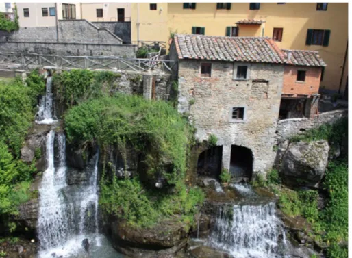
figure 3. loro ciuffenna, Tuscany, medieval village with the oldest water mill (photo i Rintronauti, 2018).
to implement associated service management interventions. To support these actions there is the 2016-2022 national operative Programme (Pon), beneficiary department of the Public function, there are 4,400,000 euros14.
at 10/2018, two actions are underway15. action 1 is dedicated to the structuring and updating of the database monitoring system. This is useful for: expanding the information base, the analysis of the territorial-administrative context on a municipal basis, the general verification of all 72 areas, and the precise detection of 66 of them and the realization of 19 on-site meetings for the verification
14. Agenzia per la coesione territoriale, dipartimento funzione pubblica, Progetti, 2019, http://www.ot11ot2.it/dfp-organismo-intermedio/progetti/aree-interne (accessed march 6th 2019).
15. agenzia per la coesione Territoriale, dipartimento funzione pubblica, Aree Interne. Nuovi Assetti Istituzionali e sistema intercomunale. Strategia Nazionale per le Aree Interne, 2019, http://www.funzionepubblica.gov.it/progetti-approvati#Stratnaz (accessed march 7th 2019).
912
of the associative process. action 2 has the purpose to assess the associative requirement of 30 inner project areas, the accompanying activity to 50 internal areas for the construction of the associative path through the realization of about 150 days, the organization and realization of internal areas seminars. events already held: The added value of associations (1.12.2016); The mergers of municipalities (06.21.2017); associations and strategy of economic and social development. work seminar on the short and long-term association choices of the municipalities in the area (12.04.2018); Sicilian Internal areas (11.07.2018); Processes for the merger of the municipalities (04.09.2018); SnaI coworking laboratory: interactive laboratory for interinstitutional cooperation in the Inner low Pesaro area - ancona (19-20.04.2018); national forum Internal areas 2017 (29-30.05 aliano) and 2018 (17-18.05 acceglio)
all this with the involvement of the foRmeZ starting from may 201616. The specific objectives
consist in defining the level of association to calibrate the support interventions and to monitor the progress of the integrated management processes between municipalities. The expected result is the classification of the areas based on the level of associationism in place. The project is divided into two lines of action starting on 25th may 2016 and ending on 30th June 2022. Recipients are the municipality, Region, central and peripheral Public administration17. as part of the dissemination and
communication activities, the thematic site was structured18 and implemented for a constant update
on the topics of interest of the project and the activities carried out19.
In the two-year period 2016-2018, the department for Public administration has allocated 1,500,000.00 euros for the evaluation of association processes and the actions to support their implementation, the monitoring of inter-municipal aggregation processes in internal areas, and the
16. formez - center, founded in 1965 for the extraordinary interventions for Southern Italy, then transformed in producer of services, assistance, studies and training for the modernization of Public administration; Focus per La Strategia Nazionale per le Aree Interne e i suoi assetti istituzionali, http://focus.formez.it/content/strategia-nazionale-aree-interne-e-nuovi-assetti-istituzionali (accessed march 5th 2019).
17. Project manager: c. fusco; Tags: internal areas, SnaI, structural funds 2014-2020, territorial governance, associationism, union of municipalities, delrio law; client: department of Public administration.
18. Territori in rete per La Strategia Nazionale per le Aree Interne e i suoi assetti istituzionali, http://territori.formez.it/ (accessed march 6th 2019).identified théline:re bisogna iscriversidalla bibliografia ed eventualmente messo in nota, dove attualmente manca)are)
19. Agenzia per la coesione territoriale, dipartimento funzione pubblica, La Strategia Nazionale per le Aree Interne e i suoi assetti istituzionali, 2019,
Reflections and Hypotheses
identification of the best association practices, promoting the strengthening of the administrative capacities of local governance as a whole.
all this in a coordinated way with the Pon Governance and institutional capacity 2014-2020 dedicated to the competitiveness of the territory.
The law n.158/2017 ‒ Measures for the support and enhancement of small towns, as well as
provisions for the redevelopment and recovery of the historic centers of the same municipalities20 ‒ is not a point of arrival, but of departure. even if the 150 million of financial endowments are very few, however, as Tino Iannuzzi, one of the speakers in the chamber of it, notes at the end of march 2019
«are [..]. urgent and fundamentalé [actions for…] the use of the funds already available (a total of 100 million euros provided for in law 158 and another 10 million euros per year added with the budget law for 2018 [...] continuing the commitment that I have been pursuing for years with ermete Realacci, I shared with (the honorable) enrico borghi, (another Relator of the law), the need for a Question to the President of the council, to the ministers of the Interior, for cultural heritage, Infrastructures and for the Public administration [...] where it is requested] the adoption of the decrees to which law 158 refers, for its [...] implementation [...] the decree to define the list of the most disadvantaged municipalities that can benefit from the funding, based on the established criteria (economic backwardness; depopulation; old age index of the population; lack of essential services; areas affected by hydrogeological instability) or included in national or regional parks); (recalling that) the minister for cultural heritage is in charge of promoting the creation of tourist-cultural and enogastronomic circuits and itineraries connected to the historical railway network (and to) minister of administrative Simplification […] identifying specific initiatives of technological innovation and e-government programs. furthermore, the law allows Small municipalities to benefit from the measures envisaged by cIPe resolution no. 65/201 [...] for access to broadband and ultra-broadband, to the Internet21. at the same time, a tight activity is required for the preservation and strengthening of essential public services. The law has established the general principle of the protection and maintenance of fundamental services, whose concrete application requires a strong action of the public institutions: for postal services, the school network, health facilities, and the law enforcement agencies. In anas and ferrovie dello Stato it is up to grant the Small municipalities houses for roadmen and abandoned and disabled railway stations to allocate them to protections of civil protection, to places of promotion of typical local products. The agri-food products coming from short chain or “zero” kilometers must also be valued [….] 20. a. de caro, Primo firmatario Ermete Realacci Ddl sui piccoli comuni: sì bipartisan dal Senato, ora è legge, 28 settembre 2017, http://www.rainews.it/dl/rainews/articoli/legge-piccoli-comuni-si-bipartisan-senato-dc49320b-f636-44ba-abe6-e799152b1abc.html (accessed march 27th 2018). outcome of a long battle carried out mainly by ermete Realacci, currently honorary president of legambiente, and Vittorio emiliani, a journalist known for his many battles for the defence and protection of the environment and the historical and artistic heritage, one of the Park’s “fathers” archaeological museum of appia antica in Rome, and newspapers including «Il corriere della Sera».
21. «I am very pleased with the announcement made yesterday by the european commissioner corina cretu, who coordinates regional policies, regarding the allocation of 573 million euros of european funds for the development of the ultra-wideband plan» says (2019) marco bussone, President of the national union of communities montani institutions (uncem) after the meeting organized also with the european deputy mercedes bresso, President of Piemonte Region between 2005 and 2010.
914
the binding principle of law 158: Small municipalities, in the allocation of financial resources and in the organization of public services, are entitled to receive differentiated treatment, which goes well beyond the number of inhabitants, in order to ensure and promote the their life and their activity. only in this way can the mission that indicates the law be realized: translating the sense of community so strong in these municipalities, the value of identity and love for roots in a large investment that combines cultural and historical traditions and technological innovation; handicrafts, typical productions and excellent agriculture; landscape and environmental beauties, liveability in ancient villages and ability to intercept new segments of tourist demand»22.
They are a great, potential, territorial “reserve” that must be defended and protected to face the growing threats deriving both from the climatological transformations underway and from the concentration of tens of millions of inhabitants in a few concentrated and increasingly unlivable places. The greenhouse effect and the associated climate change is already the cause of the abandonment of many islands in Poinesia and in areas of new Zealand due to the rise of the sea. Several studies show a similar risk for the area of manhattan, new York, Singapore and Paris, which has seen the Seine flood several times. So many hundreds of millions of people will be forced to find new areas to live. while the increasingly strong push that economic, often transnational, interests have been giving for decades to the expansion of some urban poles means that these become increasingly congested and unlivable. This will push an increasing number of individuals to look for places where they can have an acceptable quality of life: on the other hand, it should be noted that for years it has been found to be high in small towns such as Todi (PG)23 and that in any case in the rankings carried out on a world scale at the top is Vienna which counts approx only 2 million residents24.
alongside the political strategies, the rules and funding, in these territories there have long been initiatives of “autopoiesis”, self-organization25, a sort of “place based” approach proposed by
22. Press release, Legge sui piccoli comuni, Iannuzzi sollecita attuazione. Appello al Governo, https://www. infocilento. it/2019/03/29/legge-sui-piccoli-comuni-iannuzzi-sollecita-attuazione/ (accessed march 27th 2019) (english translation by the author).
23. In 1990 a research by Kentucky university, taken up by the new York Times, defined Todi, ca. 16,000 inhabitants, The most liveable city in the world, in 2010 the municipality organized the convention From liveability to sustainability, an ideal city 20 years later.
24. Quality of Living City Rankings, https://mobilityexchange.mercer.com/Insights/quality-of-living-rankings (accessed September 5th 2018).
Reflections and Hypotheses
figures 4a-b. Polarity and Internal areas of the National Strategy of Internal Areas (from agency for Territorial cohesion, 2013, http://www.pongovernance1420.gov.it/it/progetto/la-strategia-nazionale-per-le-aree-interne-e-i-nuovi-assetti-istituzionali/ (accessed march 5th 2019).
barca since 200926. This is the case of the Ecomuseum of the ironworks and foundries of Calabria, archaeological, monumental, environmental park of the communities and of the testimonies of the first Southern industrialization in the areas of mongiana (VV), bivongi (Rc), Pazzano (Rc) and Stilo27 (Rc) in the Valley of the Stilaro28 (figs. 4a-b,5-6).
26. f. barca, Un’agenda per la riforma della politica di coesione. Una politica di sviluppo rivolta ai luoghi per rispondere alle sfide e alle aspettative dell’Unione Europea. Rapporto indipendente (2009) per D. Hübner, Commissario europeo alla politica regionale, 2010, https://europa.eu/european-union/index_it (accessed September 5th 2018).
27. Respectively with 712, 1343, 529 and 2542 residents.
28. f. danilo, Ecomuseo delle ferriere e fonderie di Calabria, Parco archeologico, monumentale, ambientale delle comunità e delle testimonianze della prima industrializzazione Meridionale, http://web.tiscali.it/ecomuseocalabria/ (accessed march 5th 2019).
916
left, figure 5. The area of the Industrial Pole (Ecomuseo, 2019). f. danilo, Ecomuseo delle ferriere e fonderie di Calabria, Parco archeologico, monumentale, ambientale delle comunità e delle testimonianze della prima industrializzazione Meridionale, pubblicato on-line: http://web.tiscali.it/ecomuseocalabria/ (accessed march 15th 2019); under, figure 6. mongiana (Vibo Valentia). Ruins of the foundry, https://it.m.wikipedia.org/wiki/ file:Resti_fonderia_di_mongiana_(2018).jpg (accessed June 14th 2020)
Reflections and Hypotheses
figure 7. acri (cosenza), museum of contemporary art, http://www. museomaca.it/index.php?option=com_
content&view=article&id=29&Itemid=128&lang=it (accessed march 1st 2019).
another example is the museum of contemporary art, maca, in acri29 (CS), an original enhancement of glass processing, exhibitions and initiatives with reuse of the eighteenth-century Palazzo Sanseverino-falcone (fig. 7).The muSaba - Parco museo laboratorio Santa barbara is one of the oldest experience (fig. 8). It has been created in 1986 by the Spatari/maas foundation, a non-profit moral institution. This is a creative and intellectual foundation, an integration of art, science, architecture, environment, archeology, biological agriculture and relevant research to the artistic and cultural heritage of the mediterraneo in the heart of calabria, in the extreme south of Italy, the province of Reggio calabria. located in the Torbido Valley south-east of the town of mammola (Rc), 2746 inhabitants, it is 10 kilometers from the Ionian Sea, and has been created by the artists nik Spatari and hiske maas since 1969. The heart of muSaba is the museum-laboratory located in a multi-faceted building obtained from the remains of the ancient monastic “grangia”, the ancient complex (the first church was built between 300 and 450, rebuilt in the following centuries, the last architectural restructuring dates back to 1300 by the carthusian monks) with necropolis dating back to the 11th-7th century bc and a protohistoric settlement that overlaps between the 5th and 4th century bc30.
29. city that has about 20.000 inhabitants, therefore bigger than the centres considered, but it is internal and difficult to access.
30. Parco Museo Santa Barbara, http://www.mondodelgusto.it/territori/ 4376/parco-museo-santa-barbara (accessed march 9th 2019).
918
Reflections and Hypotheses
figures 9-11. Riace (Reggio calabria), from left, entrance to the historic centre; the donkey stables for waste collection and Passage towards the valley (photo S. aragona, 2018).
The example of Riace (Rc) is also magnificent with the recovery and revitalization of the historic centre thanks to an intelligent local immigration management strategy established in 2006 thanks to the cooperation between the La Città del Sole (city of the Sun) community31, monsignor Giancarlo
maria bregantini, then bishop of locri-Riace, and Riacese emigrants abroad, owners of the buildings unable to keep them. as Sonia montella wrote in 2017, the country, after having seen its population halved in just a few years, rising to only 2309 residents, was reborn (figs. 9-11). currently, due to questionable options of various kinds, political and judicial, this “laboratory” is in crisis and the activities are closing32.
31. Tommaso campanella, author of the homonymous text, came from Stilo (Rc).
32. S. montella, Riace si scopre multietnica e piace ai turisti, https://www.agi.it/cronaca/riace_immigrati_sindaco_ lucano_ bronzi-1739872/news/2017-05-04 (accessed September 27th 2017); c. bellomi, Riace, il paese sospeso che rischia di fallire, http://www.famigliacristiana.it/articolo/riace-il-modello-spospeso-che-rischia-di-fallire.aspx (accessed december 9th 2018).
920
The Society of Territorialists33, among the many who adhered to the network of the 100 cities of
the early 1990s, has for years been devoting to these topics with analyzes, proposals, initiatives. The 2017 annual conference took place in the small reality of matelica (mc), and the emblematic title was From the territories of resistance to heritage communities. Self-organization and self-government
paths for fragile areas. The involvement of the population is essential in every type of option. In this
sense the River Contracts (fig. 12) offer an important opportunity34. opportunities that the calabria
Region has, before the South, included in its urban planning instrumentation and started meetings with the association of local action Groups35.
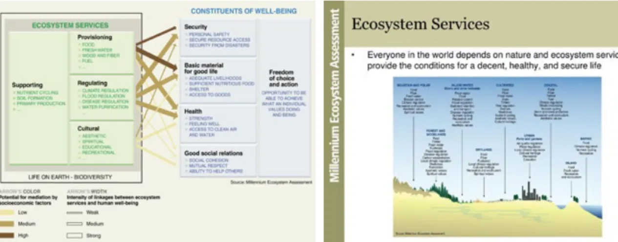
These examples are also privileged places to embody ecosystem Services36 as can be deduced
from the four main categories, namely life support (eg. soil formation), procurement (eg. food), regulation (eg. erosion control), cultural values (eg. aesthetic or religious) reported in fig. 12 together with the identification of the earth’s biomes.
however, it must be remembered that in the national support strategies essential territories are the ordinary funds allocated. luca bianchi, SVImeZ researcher, in 2018 has illustrated at the XXXIX aISRe (Italian Regional Science association) conference that the various Governments have cut to the southern regions approx. 35 billion of euros37, over 2 in central Italy38. The smaller you are,
the more this creates further disadvantages, problems. All that with a network of health and social services that is highly deficient if compared to that of central and northern Italy (fig. 13).
33. besides others, these include alberto magnaghi, anna marso, enzo Scandurra, alberto budoni, the mourned Silvia macchi and alberto Ziparo.
34. Contratti di Fiume, nuovi strumenti per la gestione delle risorse idriche, http://www.ambienteterritorio.coldiretti.it/ tematiche/acque/Pagine/contrattidifiume,nuovi (accessed may 27th 2018).
35. Contratti fiume, firmato accordo tra Regione e Assogal, http://www.regioni.it/dalleregioni/2017/03/29/calabria-contratti-fiume-firmato-accordo-tra-regione-e-assogal-506953/ (accessed January 5th 2019).
36. ISPRa, I Servizi ecosistemici, http://www.isprambiente.gov.it/it/temi/biodiversita/argomenti/benefici/servizi-ecosistemici (accessed June 14th 2018).
37.. l. bianchi, c. Petraglia, Federalismo differenziato e diritti di cittadinanza, Tavola rotonda Autonomia, capacità fiscale e federalismo, XXXIX conferenza Scientifica aISRe le regioni d’europa tra identità locali, nuove comunità e disparità territoriali, (bolzano 17 -19 settembre 2018).
Reflections and Hypotheses
figure 12. description of River Contracts (elaboration of G. bruni, 2018, corso La qualità nella progettazione territoriale e urbana, professor Stefano aragona, cdl magistrale architettura – Restauro, university mediterranea of Reggio calabria).
922
figure 13. classification and identification of the main ecosystem services of biomes (from millenium ecosystem assessment Synthesis 2005).
Concluding notes
attention to the so-called minor areas, internal or otherwise, is essential to preserve the Italian landscape. Smaller and smaller villages and towns are the nodes of a territorial network built over thousands of years and that has drawn a territorial morphology that is an inestimable cultural wealth, appreciated worldwide. Places where the quality of life could be high if only essential services and infrastructure were present or maintained. certainly following a philosophy different from the economist one in assessing the well-being going, as ezechieli suggests since 2003, beyond the canonical economic indicators: a line of thought to which the fair and Sustainable well-being refers, beS, a complex indicator elaborated by ISTaT together with the cnel starting in 201339 and the work theme of the 1998 nobel Prize in economics amartya Senn.
It is necessary to concur with political will that interrupts the growing isolation of these areas, overturning the microeconomic vision of these over 35 years that is favoring few areas and in them few subjects increasing, moreover, the various congestions and pollution. They are able to grasp the potential of small and very small centers, as we said, material and social “reserves”.
Reflections and Hypotheses
we need a growing commitment of local institutions in spreading these opportunities and in/ forming their populations both on present opportunities and on risks. Recalling, however, that being historical anthropization does not mean security regarding the risks of various nature, from the seismic to the hydrogeological or other. on the contrary, sometimes the ignorance in the past of the fragile conditions of a territory has been the cause of dramatic events.
Then there are opportunities that are lost, such as that of matera, city of culture 201940. emblematic of “attitudes” and deeper cultural problems. despite the fact that the university has been pursuing initiatives and events for years such as the national design workshop Ideas and
projects for recovery and rehabilitation in smaller areas and not in the age of globalization held in
2005 in Tropea, a well-known and renowned touristic and cultural place41. But there were problems of hospitality since only one hotel facility was open, and it was outside the centre. with virtually no railway connections (figs. 14a-b). opportunities that can mean inserting smaller areas into larger strategic plans such as the proposal to create a metropolitan area characterized and formed by many small realities, in a network of innovation, history and territories42.
40. Matera 2019: l’opportunità mancata? http://www.cgilbasilicata.it/176455-matera-2019-l-opportunita-mancata. html (accessed march 5th 2019).
41. It was one of the places visited and designed by the flemish painter escher in 1931, during his Grand Tour in the South, and which inspired the workshop Poster and the brochure of the Program.
924
figures 14a-b. above, world health organization, Ecosystem and Human Well-Being,
https://www.millenniumassessment.org/ documents/document.356.aspx.pdf, p. 15 (accessed June 14th 2020); left, Island Press, millenium ecosystem assessment, A Toolkit for Understanding and Action Protecting Nature’s Services. Protecting Ourselves, 2007, p. 4, http://dev.ecoguineafoundation.com/ uploads/5/4/1/5/5415260/millenium_ecosystem_ assessment_toolkit.pdf (accessed 14th June 2020).
Reflections and Hypotheses
Bibliografia
aragona 1993 - S. aragona, Infrastrutture di comunicazione, trasformazioni urbane e pianificazione: opzioni di modelli territoriali o scelte di microeconomia?, in atti della XIV conferenza italiana di Scienze Regionali, Per un nuovo regionalismo. Istituzioni, politiche regionali e locali, modelli di analisi e decisione (bologna, 6-8 october 1993), franco angeli, milano 1993, pp. 1211-1230.
aragona 2010 - S. aragona, Condizioni locali come suggerimenti progettuali: verso una metodologia di piano/progetto della città ecologica, in f. moccia. (ed), Abitare il futuro…dopo Copenaghen/Inhabiting the future... after Copenhagen, Proceeding of the conference (naples, 13-14 december 2010), clean, napoli, 2010, pp. 1029-1043.
aragona 2015 - S. aragona, Reggio Calabria: metropoli in rete di innovazione, storia e territori, in c. fallanca (ed.), 100 IDEE per Reggio Calabria Città Metropolitana, aRacne, Roma 2015.
cacciari 1991- m. cacciari, Aut Civitas, Aut Polis, in e. mucci, P. Rizzoli (eds), L’immaginario tecnologico metropolitano, franco angeli, milano 1991, pp. 31-36.
coscetta, emiliani, Sanfilippo 2014 - P. coscetta, V. emiliani, m. Sanfilippo, Mille borghi Cento città Un Paese: Libro Bianco sull’Italia delle origini, minerva edizioni, bologna 2014.
ezechieli 2003 - e. ezechieli, Beyond Sustainable Development: Education for Gross National Happiness in Bhutan, Stanford university, Stanford 2003.
Island Press 2007 - Island Press, Millennium Ecosystem Assessment A Toolkit for Understanding and Action Protecting Nature’s Services. Protecting Ourselves, 2007, Islandpress, washington 2007, http://www.truevaluemetrics.org/dbpdfs/ ecoSystem/mea/mea-millennium-ecosystem-assessment-Toolkit.pdf (accessed august 30th 2020).
ISPRa 2019 - ISPRa, Definizione del metodo per la classificazione e quantificazione dei servizi ecosistemici in Italia, http:// www.isprambiente.gov.it/files/biodiversita/SeRVIZI_ecoSISTemIcI.pdf (accessed march 27th 2019).
ISTaT-cnel 2013 - ISTaT-cnel, Bes 2013 Il Benessere Equo e Sostenibile in Italia, Tipolitografia cSR, Roma 2013. lucatelli 2016 - S. lucatelli, Strategia Nazionale per le Aree Interne: un punto a due anni dal lancio della Strategia in «agriregionieuropa», XII (2016), 45, https://agriregionieuropa.univpm.it/it/content/article/31/45/strategia-nazionale-le-aree-interne-un-punto-due-anni-dal-lancio-della (accessed november 9th 2017).
maturana, Varela 1987 - h. maturana, l. Varela, L’albero della conoscenza, Garzanti, milano 1987.
meadows et alii 1972 - d.h. meadows, d.l. meadows, J. Randers, w.w. bherens, I limiti dello sviluppo, Club di Roma, mondadori, milano 1972.
montella 2017 - S. montella, Riace si scopre multietnica e piace ai turisti, https://www.agi.it/cronaca/riace_immigrati_ sindaco_lucano_ bronzi-1739872/news/2017-05-04 (accessed September 27th 2017).
Raffestin 1987 - c. Raffestin, Repères pour une théorie de la territorialité humaine, in «cahier», 1987, 7, pp. 263-279. world health organization 2005 - Word Health Organization, Ecosystems and Human Well Being. Health Synthesis, https://apps.who.int/iris/bitstream/handle/10665/43354/9241563095.pdf;jsessionid=ee0afe6953d6c70beedeb9b 3c8cda5ca?sequence=1 (accessed august 30th 2020).
ArcHistoR EXTRA 7 (2020)
www.archistor.unirc.it ISSN 2384-8898
Supplemento di ArcHistoR 13/2020
a cura di Annunziata Maria Oteri Giuseppina Scamardì
u n pa e s e c i v u o l e
Studi e prospettive per i centri abbandonati e in via di spopolamento
o n e n e e d s a t o w n
S t u d i e s a n d p e r s p e c t i v e s f o r a b a n d o n e d o r d e p o p u l a t e d s m a l l t o w n s
ISBN 978-88-85479-09-8
The essay deals with a significant experience of Associated Structural Planning, which regards four municipalities of the inner area of Crotonese (Caccuri, Castelsilano, Cerenzia and Savelli), which are part of the National Strategy for Inner Areas. The lines of intervention have been defined as part of a broad framework of objectives aimed at enhancing the endogenous resources of culture and historical centres. They are considered the most important assets to set up a sustainable development policy to offer better opportunities for life and work and allow the population to stay.
The Plan is mainly based on enhancing the common characteristic and values of these territories, particularly in terms of cultural heritage, knowledge, and productivity that the area has and can offer. The valorization of the historical centres and the peculiar elements of local identity, the historical buildings, the traditions of the material culture, and the traditional “know-how” are considered fundamental. Following the primary purpose of the National Strategy for Inner Areas,
the final aim of the Plan is to hinder the increasing phenomena of depopulation.
Enhancement of Small Historical Centres to Hinder Depopulation
Sante foresta† (università degli Studi mediterranea di Reggio calabria)
o n e n e e d s a t o w n
S t u d i e s a n d p e r s p e c t i v e s f o r a b a n d o n e d o r d e p o p u l a t e d s m a l l t o w n s
Valorizzare i centri storici minori per contrastare
lo spopolamento
Sante foresta†
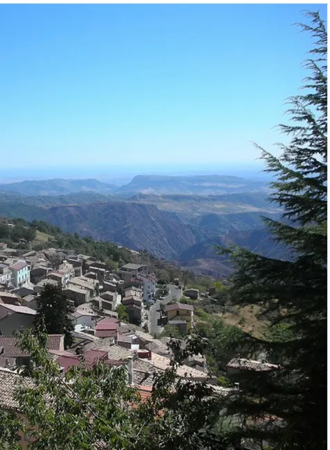
nel 2009 i comuni di caccuri, castelsilano, cerenzia e Savelli in calabria (fig. 1), hanno inteso promuovere la redazione del Piano Strutturale in forma associata1 (di seguito PSa). Si tratta di comuni
con caratteristiche territoriali e storico-culturali omogenee per i quali, dunque, questo strumento previsto dalla legislazione regionale, consente una programmazione condivisa delle strategie di sviluppo e tutela del territorio; obiettivo questo, che si è poi ritrovato in linea con le strategie nazionale e regionale per le aree interne (SNAI e SRAI2) varate a livello nazionale e regionale dal 2014. nota delle curatrici: per la prematura scomparsa dell’autore, il presente saggio è pubblicato nella forma da lui consegnata in bozza nel settembre 2019 con la sola revisione redazionale. non tiene dunque conto di eventuali aggiornamenti sul tema dopo quella data.
1. Il gruppo di progettazione è composto dagli architetti Giuseppe foglia e Giuseppe frontera e dagli ingegneri Giovanni Raimondo e filippo walter Sidoti. a chi scrive è stata affidata la consulenza tecnica specialistica per la pianificazione strutturale: arch. Sante foresta e la consulenza tecnica specialistica per la Valutazione ambientale Strategica all’architetto maria Giuseppina Pezzano.
2. la regione calabria si è dotata nel 2014 di una Strategia Regionale per le aree Interne (SRaI), con l’obiettivo di ampliare il numero di aree già selezionate nella Strategia nazionale (SnaI) nella quale ricadevano già i comuni oggetto del presente saggio, http://regione.calabria.it/calabriaeuropa/calabriaeuropa/images/Strategia%20aree%20interne%20 revPP%2019%2010%2015.pdf (ultimo accesso 16 settembre 2019).
928
Valorizzare i centri storici
In particolare, gli obiettivi delle amministrazioni comunali coinvolte, che nel 2015 hanno deliberato sull’adozione del documento preliminare del PSa, è di elevare il livello di integrazione progettuale con gli strumenti di pianificazione strategica e di programmazione economico-sociale a livello intercomunale, provinciale e regionale. a diversi livelli, il PSa intende garantire il coordinamento metodologico delle iniziative intraprese e da attivare, nonché agevolare la pianificazione integrata delle risorse territoriali con particolare riferimento alle valenze intergenerazionali riferite ai sistemi paesaggistico-ambientale e storico-patrimoniale.
Il PSa costituisce una modalità di pianificazione e programmazione che si svolge tra la Regione e altri soggetti pubblici, con la condivisione delle parti sociali e dei soggetti privati interessati, tesa a realizzare le condizioni per lo sviluppo locale sostenibile, in coerenza con gli strumenti della pianificazione e programmazione regionale e provinciale e con particolare riferimento al processo indicato all’articolo 13 della legge urbanistica Regionale3. I Comuni di Caccuri, Castelsilano, Cerenzia
e Savelli4, in ragione delle loro funzioni pianificatorie e programmatorie, hanno individuato nel PSa
lo strumento idoneo per risolvere le disparità esistenti tra competitività del sistema produttivo e sviluppo sociale, urbano e territoriale.
Breve profilo storico
I paesi in questione appartengono alla comunità montana alto crotonese e marchesato5 e
sorgono sulla fascia collinare e montuosa che fa da corona alla vasta piana sottostante. È questa una regione geografica che mostra una forte e ben connotata identità storico-culturale: non è un caso che ancora oggi essa venga inequivocabilmente identificata con il toponimo ‘U Marchesatu, il marchesato. come affermava lucio Gambi,
«Vi è solo una zona della calabria: cioè il marchesato di crotone, che ha conservato fino a oggi, con valore in qualche modo legato a quello originale, il nome ufficialmente imposto nel 1390 […]. e questo perché buona parte della sua area 3. legge urbanistica Regionale del 16 aprile 2002, n. 19 Norme per la tutela, governo ed uso del territorio; Legge urbanistica della calabria (buR n. 7 del 16 aprile 2002, supplemento straordinario n. 3).
4. le amministrazioni comunali di caccuri, castelsilano, cerenzia e Savelli, attraverso Giunta e consiglio comunale, hanno deliberato nel merito del PSa tra febbraio e aprile 2015.
5. assieme a Pallagorio, Verzino e umbriatico (sede) hanno composto l’ambito territoriale della comunità montana alto crotonese fin dalla sua istituzione nel 1974. nel 1999 l’ambito territoriale fu ampliato e l’ente prese il nome di comunità montana alto crotonese e marchesato, spostando la sede a cerenzia, per ragioni di centralità territoriale.
930
(intorno a 800kmq nei limiti originali) per la radicata dominazione di una unica e forte famiglia baronale – la famiglia Ruffo – sino al 1444, finì per configurarsi a mano a mano e rimase anche dopo la frantumazione di quella casata e dopo l’eversione della feudalità, come regione bene individuabile da quelle vicine»6.
Il vasto feudo ebbe dunque origine come tale nel 1390 per volontà della regina margherita d’angiò-durazzo, che lo assegnò a carlo Ruffo, conte di montalto7, ma anche quando le successive
vicende storiche lo videro disgregarsi in una miriade di possedimenti più piccoli – per confische o compravendite – il territorio mantenne salda la sua identità, tanto che con la legge eversiva della feudalità del 2 agosto 1806 il termine marchesato rimase ancora a indicare la sub-regione. fino alla riforma agraria del 19508, il «tacco calabrese», come veniva definito da manlio Rossi doria9,
fu uno «dei più tipici territori latifondistici d’Italia»10, “il latifondo” per antonomasia, proprietà dei
ricchi signori, blasonati e non. Il paesaggio è uniformemente caratterizzato da dune e terrazzamenti, destinate a colture agricole estensive, particolarmente grano, e a uliveti. ancora oggi l’intera area è zona di produzione di una specifica varietà di olive, la “carolea”, da cui si ricava l’olio dop “alto crotonese”, per il quale sono fondamentali «le caratteristiche di coltivazione, le condizioni ambientali e di coltura degli oliveti che dovranno essere quelle tradizionali della zona, per conferire alle olive e all’olio derivato le specifiche caratteristiche»11.
le colture in passato non necessitavano della costante presenza dei braccianti, i quali potevano compiervi brevi migrazioni stagionali dalle proprie residenze. Queste erano poste nei paesi arroccati sulla corona collinare, la cui ubicazione era atta alla difesa sia dalle incursioni corsare, sia dalla malaria delle aree costiere. le descrizioni dei viaggiatori, ancora in tempi recenti, raccontavano questi luoghi come caratterizzati da paesaggi uniformi e compatti, ma privi di qualsivoglia infrastruttura, così da dare una sensazione di arretratezza agraria e sociale12, reale solo in parte.
I nomi di alcuni dei borghi e la loro storia testimoniano le connotazioni feudali del territorio. Savelli, ad esempio, prende il nome da donna carlotta Savelli, figlia di Paolo, principe di albano, che favorì l’insediamento sulle sue terre di famiglie provenienti da carpanzano e Scigliano, devastate
6. Gambi 1965, p. 199.
7. Per le famiglie e le successioni feudali vedi, tra gli altri, Galasso 1965; caridi 1995; Scamardì 2002a. 8. caniglia, Passalacqua 2019.
9. Rossi doria 1950. 10. Ivi, p. 1178.
11. G.u. n. 56 dell’8 marzo 2001. 12. carratelli 1949.