Carlo Citter*, Giuseppe Maria Amato, Valentina Di Natale, Andrea Patacchini
A Stratified Route Network in a Stratified
Landscape. The Region of Enna (Central Sicily)
from the Bronze Age to the 19 th c. AD.
https://doi.org/10.1515/opar-2017-0020
Received March 15, 2016; accepted October 17, 2017
Abstract: This paper focuses on the region of Enna in central Sicily. Its peculiar environmental setting is a key feature, with a central mountain surrounded by gentle, fertile lowlands. Our key question is to understand the regional route network in its historical process of “transformission”, a concept proposed by French archaeogeographers (see Chouquer, Watteaux 2013). It considers traces on the landscape at different scales, as ever-changing features influenced by both natural and human inputs. We chose a sample area of 566 sq-km in the very centre of the island and we evaluated geographical constraints on mobility. This raises new questions about the relationship between routes, settlements, and the environment.
Keywords: resilience, routes, landscape, least cost path
1 Introduction
The sample area we chose has a particular geographical context: high relief like Enna and Assoro (respectively, 997 and 901 m.a.s.l.) surrounded by lowlands. These are gentle hills converging into the two main river valleys of Salso-Cimarosa (north) and Dittaino (south). We studied the main historical routes connecting Enna to the town of Agira and made several simulations of potential routes, based on environmental constraints and attractors. The results are discussed at the end of the paper (fig. 1). The archaeological data used for this work have not been collected within a single survey project, but derive from the body of literature that has accumulated since the 19th century. This, of course, has had some impact on our overall knowledge. We do not focus on settlements.
2 Historical Background
Humans have been present in this region since the Palaeolithic, as the Riparo Longo near Agira shows (Guerri, 1979). Later, Copper and Bronze age settlements have also been identified (a recent, updated overview of the region from the Palaeolithic to the Iron Age is in Giannitrapani, 2012). The main sites of Agira, Assoro, and Enna are recorded in the first literary references with the same names, and we would
Original Study
Article note: This article is a part of Topical Issue on Uncovering Historical Routes for Sustainable Mobility: Methods, Tools
and Case Studies.
*Corresponding author: Carlo Citter, Department of History and Cultural Heritage, University of Siena, Italy,
E-mail: [email protected]
Giuseppe Maria Amato, Independent researcher
argue that these place-names derive from ancient, local languages. Later, these were incorporated into the “Siculo” language, which was used until Roman times. The area between these towns did not have major routes apart from that connecting Enna to Agira, as both Tabula Peutingeriana and Itinerarium Antonini show (the latest updated analysis of this is in Uggeri, 2004, pp. 279–286) (fig. 2). This road was part of a major connection, Catania-Termini, that linked the Thyrrenian to the Ionic sea. Additional routes used to connect Enna with the harbours on the northern coast.
Agira is a remarkable Hellenistic town of Sicily. According to Adamesteanu (1962a), the route connecting Agira to Morgantina passed through the foothills of Monte Santà. Here they found traces of a small sanctuary dating to the 5th to 4th c. BC (De Miro, 1983). This is an easy path to walk through. A high density of Greek settlements along it points to its importance over time. Though most of the data for hilltop sites relates to the Greek period, only intensive excavations can exclude a Bronze age phase. In many other regions of Italy it is rather common to find a Bronze Age settlement on the hilltop, which is later reoccupied several times.
The main routes shifted northward after the founding of Nissoria (18th c. AD) and Leonforte (17th c. AD). Assoro is another key feature in this landscape. Its strategic position from a geographical point of view is indisputable. It is likely that the peasants used to exploit the surrounding fertile land, possibly within a major estate (latifundium). But we cannot exclude the idea that they used to live in town. Several researchers studied this area; it is worth mentioning Bernabò Brea (1947), Morel (1963), Adamesteanu (1962b), and De Miro (1983). Furthermore, writers and geographers were interested in Assoro even before the Grand Tour (e.g. Amico, 1757–60, Houël, 1782–87). Their descriptions are relevant due to the major changes of this landscape in recent decades. The ancient town of Enna has been occupied since the Bronze age (De Agostino, 1942–43), though in the nearby foothills a Copper age site has been excavated (Giannitrapani and Iannì, 2015). We have no literary reference, but we think the town developed as the result of a synecism between the 7th and 6th c. BC. It soon developed close relationships with major Greek towns like Gela and Syracuse. However, its relevance to urban development and hierarchy in Sicily is rooted in local cults, later
incorporated into the Greek pantheon: Demetra and Kore–Persephone (Smith, 1867). Thus, Enna was both a strategic and a religious place until the end of the Roman period, after which it played only a military role, as the name Castrum Hennae proves (Amari, 1854–1872).
Fig. 2. Pictures of the main places mentioned within the text: 1 Dittaino’s valley from Cozzo Matrice, 2 Enna from Cozzo
Matrice, 3 Agira from Assoro, 4 Agira from Ennas’ castle, 5 the road Enna–Agira at Piano Murra, 6 the medieval road entering in Lenoforte, 7 medieval road at the foothill of the castle of Guzzetta.
Thanks to its geographical position, Enna was one of the principal strongholds of the Thema Sikelias (the Byzantine province of Sicily). Later, it became the centre of the Islamic administration. It is not by coincidence that the region surrounding Enna is called the “Sicily of the crops”; during the middle ages, a wide variety of crops were cultivated, including rice, vines, sumac, pistachios, almonds, and sugar cane. Sheep and goat-breeding, as well as legume cultivation, facilitated a three-yearly fallow cycle. However, from Cicero’s mentions to the modern corine land cover map, agriculture has remained the main economy of central Sicily (fig. 3).
There are various geographical constraints to movement through the area, but these must be considered within a historical framework in order to evaluate the sustainability of the route network through time.
Fig. 3. Corine land cover soil map est. 1990 and the evaluated routes.
3 Method
Our method is based on two converging approaches. The first is topographical: we evaluate literary sources, itineraries, historical maps, and archaeological data. The second is focused on the making of cumulative cost surfaces within a GIS platform to run several potential scenarios regarding mobility in this region. The IGMI (Italian Geographic Military Service) map from the 1930s is a good base map from which to evaluate historical routes connecting Enna to Agira. In fact, these did not change a lot until recently. The new road at the foothill of the castle of Guzzetta is further proof of this (fig. 2:7).
We can reconstruct three main historical routes (fig. 4). The first one (A) seems to be the most ancient. It was used by Greek colonists (Uggeri, 2004, pp. 235–250) as a section of the major route Termini–Catania. It passes through Assoro and it is likely it was the major road since the Islamic period, though we still lack archaeological evidence for this. The second one (B) passes through Leonforte (founded in AD 1610) on a pre-existing site. It seems to be a branch of route A. The last one (C) used to run through the foothills of the castles of Tavi and Guzzetta. We can date it to the late middle ages with a certain degree of confidence.
We uploaded these data into the GIS platform (Qgis 2.14) in order to work on the potential paths. We ran a three-step evaluation according to Arnoldus-Huyzendveld, Citter, Pizziolo (2016): prediction, verification
survey, postdiction. We considered fresh-water sources and settlements as attractors and steep slopes and streams as obstacles. The procedure is composed of a first step in which we generate a raster map by weighting each factor on a scale from 0 (advantage) to 100 (disadvantage). Following this, we undertook a further weighting process by uploading the raster maps into the raster calculator. In this phase we chose how much each factor should be weighted compared to the others. This procedure is detailed in Citter, Arnoldus-Huyzendveld (2011, p. 87). The output is a raster map, which simulates the cost of moving within that specific weighted landscape from a starting point (Enna) in any direction. We had no LIDAR data available for this study. Thus, we had to work with the ASTERGDEM (http://gdem.ersdac.jspacesystems. or.jp/). Of course, this affected the final result due to its low resolution (27 m cellsize). We extracted the slope as a percentage, which we reclassified in 8 classes and weighted. Here are the details: 0% = 3, 0–5% = 1, 5–10% = 5, 10–20% = 10, 20–35% = 20, 35–50% = 50, > 50% = 100. The stream network has been uploaded from the national geo-portal. We selected only the major rivers. We then generated a multiple ring buffer on it (respectively, 20 and 60 m). This allowed us to simulate the obstacle to cross the river and the facilitator to walk through its narrow valley-bottom. We chose two series of values to weight these factors. In the first one hydrography is an obstacle. Thus, the two buffers were weighted 20m=100 and 60m=0, respectively. We also assigned 0 to the rest of the area to avoid any influence on the calculation. In the second one hydrography is an attractor. In this case, we assigned 10 to the rest of the area. Thus, the 60m buffer along the rivers represents the most profitable strip of land to walk through. We also evaluated the fresh-water sources as attractors. We made two buffers centred on them of 1 and 2 km, respectively, and we assigned the values 0 and 1. In this case we assigned 10 to the rest of the area to let the sources be more attractive. In fact, the algorithm calculates the least cost cells to move from point A to point B. If we wish to stress the role of a factor as attractor, we need to increase the weight of the remaining area. Thus, the algorithm will sense that the cells within the buffer are the most profitable and it will direct movement through the buffer. Of course, the cumulative cost surface is the result of several weighting processes. The algorithm will use the sum of the relative costs as base map for the calculation. Its output will take into account the whole procedure.
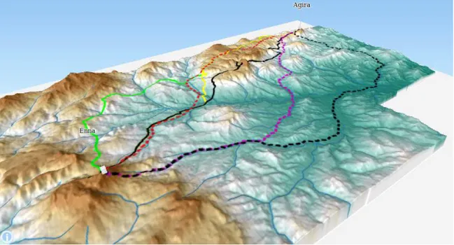
Fig. 5. The same situation in a 2.5D vision.
4 Results
After the weighting process, we ran several least-cost paths to evaluate the potential paths connecting Enna to Agira. They returned the outputs we propose in figure 4 and 5. These maps suggest that historical routes match the predicted ones on hilly areas with steeper slopes, rather than on valley bottoms with more gentle slopes. As a consequence, we should conclude that people wished to connect the two towns with the shortest path, no matter its difficulty. However, the GIS simulations returned a puzzling result; the road running through the plain measures exactly the same length as the road running through the mountainous region (30 km – path A). Thus, political reasons seem to be the best explanation. Despite a major difficulty, the need to connect the main hilltop sites was preferable to an easier path along the valley.
A cost surface where only slopes affect movement returns path 1. It runs along the river valleys and the resulting road measures 40 km. If we look at the outputs, we notice that only paths 1 and 2 run through the Dittaino valley. However, there is no trace of a historical road there. The latter is identical to that generated with the stream network as the main attractor. It follows the same direction, but it is shorter. Its length is the same as the straight uphill path Enna–Agira (A). Path 3 is the one that matches the historical routes more closely than the others. We included the fresh-water sources as an attractor in order to get this output. This last simulation allows us to argue that the importance of fresh water-availability should not be underestimated in these environmental conditions.
5 Discussion
The results of these first evaluations show that environmental factors have been effective in shaping historical route networks around Enna. If we simulate a network from Enna and Agira, combining environmental factors and the two major human settlements, we get a very similar result to that shown in figure 6.
To get this result, we changed the algorithm. Usually, researchers run it to evaluate the potential stream network. But it can be profitably used to simulate potential movement from a point in any
direction. We first calculated the cost to move at a certain distance from each town, according to the geographical settings described above. Following this, we evaluated the potential stream network. We used the tool-sets of GRASS (r.walk) and SAGA (channels). The result is a very detailed scenario of potential paths starting from the urban centres of the region. This is a very helpful procedure, which allows us to evaluate how present day routes, paths, and even field boundaries echo ancient routes. This further evaluation reinforces the idea that geographical constraints were the most influential factor affecting the direction and path of roads. However, we must be cautious when we extract meaning from an interpolation. Indeed, environmental settings affected the shaping of the historical route network first recorded in the 19th c. maps, yet this particular situation originated from the Greek decision to found towns on the hilltops. Since that period, the central places of the region did not change. Even in the modern era, when the aristocrats used to found new towns, they did not disregard the existing asset. We think this is the most remarkable conclusion: that geographical settings influenced the route network that originated from central places that were founded by the Greeks in order to control resource exploitation and protect the territory. It is amazing to underline that nothing seems to have changed until recently. After these early communities chose to settle on those hilltops, a long-lasting process of route-construction was begun. However, the Enna–Agira section is part of a longer route connecting Catania to Termini. There is no need to think of any road-planning strategy, not even in the Greek or Roman period. Several case studies prove that the routes recorded in the historical maps are the consequence of a long process of adding segments at two scales: local and regional (Watteaux 2009). We propose that the same process lies behind this main Sicilian route. For this region, we analysed the main process that occurred when the Greeks settled on the hilltops, but this may not be the case everywhere else. This double scale factor process produced the Catania–Termini route recorded in Roman and medieval sources. The postdicting approach was not intended to forecast the path – it was intended to hint at why it ran a particular way in this area.
Fig. 6. The potential route network between Enna and Agira (red). They are both considered as the focus of the network. The
References
Amari, M. (1854). Storia dei Musulmani di Sicilia. Firenze: Le Monnier.
Amico, V. M. (1757–1760). Lexicon topographicum Siculum. Panormi: Pietro Bentivenga. Adamesteanu, D. (1962a). Note su alcune vie siceliote di penetrazione. Kokalos VIII. 199–209. Adamesteanu, D. (1962b). L’ellenizzazione della Sicilia e il momento di Ducezio. Kokalos VIII. 167–198.
Arnoldus-Huyzendveld, A., Citter, C. & Pizziolo, G. (2016). Predictivity – Postdictivity: a Theoretical Framework. In S. Campana, R. Scopigno, G. Carpentiero, & M. Cirillo (Eds.), Keep the Revolution Going, proceedings of 43rd Computer Applications and Quantitative Methods in Archaeology. Siena, 2015. 593–598. Oxford: Archaeopress.
Bernabò Brea, L. (1947). Assoro: Tempio Greco e necropoli sicula. Notizie degli Scavi di Antichità 8. 249. Chouquer, G., & Watteaux, M. (2013). L’archéologie des disciplines géohistoriques. Paris: Errance.
Citter, C., & Arnoldus-Huyzendveld, A. (2011). Uso del suolo e sfruttamento delle risorse nella pianura grossetana nel
medioevo verso una storia del parcellario e del paesaggio agrario. Roma: Artemide.
De Agostino, A. (1942–1943). Studi sulla topografia di Henna. Bollettino Storico Catanese VI–VII. 117–129. De Miro, E. (1983). Sicilia occidentale. Roma: Newton Compton.
Houël, J. P. L. (1782–1787). Voyage pittoresque des isles de Sicile, de Malte et de Lipari, où l’on traite des Antiquités qui s’y
trouvent encore; des principaux Phénomènes que la nature y offre, du costume des habitans, et de quelques usages.
Paris: L’Imprimerie de Monsieur.
Giannitrapani, E. (2012). Aspetti culturali e dinamiche del popolamento di età preistorica della provincia di Enna. Studi,
ricerche, restauri per la tutela del patrimonio culturale ennese. I Quaderni del Patrimonio Culturale Ennese I. 1–37.
Giannitrapani, E., & Iannì, F. (2015). Case Bastione, Villarosa (prov. Di EN). La campagna di scavo 2014. Notiziario di Preistoria
e Protostoria, 2.II. 52–55.
Guerri, M. (1979). Riparo Longo. Rivista di Scienze Preistoriche XXXIV. 289–290.
Morel, J. P. (1963). Recherches archéologiques et topographiques dans la region d’Assoro. Mélanges de l’École Française de
Rome – Antiquité 75. 263–301.
Smith, W. (Ed.) (1867). Dictionary of Greek and Roman Biography and Mythology. Boston: Little, Brown and company. Uggeri, G. (2004). La viabilità della Sicilia in età romana. Journal of Ancient Topography, supplemento II. Galatina: Congedo. Watteaux, M. (2009). La dynamique de la planimétrie parcellaire et des réseaux routiers en Vendée méridionale. Etudes
historiographiques et recherches archéogéographiques. Thèse dactylographiée, Univ. de Paris 1 Panthéon-Sorbonne, dir.
G. Chouquer. (https://www.academia.edu/ 2614840/La_dynamique_de_la_planimétrie_parcellaire_et_des_réseaux_ routiers_en_Vendée_ méridionale._Etudes_historiographiques_et_recherches_archéographiques)