外
滩
城
市
博
物
馆
F O R O N E N E W F O R M O F M E T R O P O L I S P R O J-E C T O F T H E B U N D U R B A N M U S E U MB
U
M
POLITECNICO DI MILANO SCHOOL OF ARCHITETTURA URBANIST ICA INGEGNERIA DELLE COSTRUZIONE A.A.2016/2017 THESISB OF MASTER DEGREE CANDIDATES:LI GANLIN LIU JINGYAO YU QIANABSTRACT
Shanghai è una metropoli internazionale che è cresciuto rapidamente nel corso degli ultimi 150 anni. Perché la rapida espansione della concessi-one, ha attirato la cultura e la filosofia occidentale continuano ad affluire al Bund. Dopo l'apertura, Shanghai gradualmente trasformata in una metrop-oli internazionale, quali il Bund svolge un ruolo importante. Nella pianificazione urbanistica e indu-stria e il commercio hanno incarnato le caratteris-tiche delle moderne città occidentali. Allo stesso tempo, gli edifici del Bund anche hanno sperimen-tato tre fasi di cambiamento durante quel periodo. Lo stile architettonico, la struttura ed i materiali anche conservano le caratteristiche architettoniche della integrazione dei cinesi e occidentali, dalla fine del 19 ° secolo all'inizio del 20 ° secolo. Gli edifici del Bund è ormai diventata una cartolina di Shang-hai, che rappresenta la storia e le memorie di Shanghai, gli edifici stessi sono i migliori espo-sizioni storici e culturali. Pertanto, nella zona di Bund con un’alta densità di edifici, vogliamo trovare un modo di presentare questi monumenti culturali alle persone, lasciato la gente meglio si avvicinaro-no i vecchi edifici, quindi vogliamo costruire un museo nel mezzo del Bund lungo il fiume Huangpu.
tradizionale di più, gli edifici intorno sono anche le sue mostre. Abbiamo rotto i confini di blocchi, gli edifici stessi e le strade della città sono comunicati con l'altro insieme attraverso i diversi tipi di passag-gi. I blocchi anche non sono i blocchi tradizionali isolati di più, che la gente non può entrare. Il nostro museo con una forma di ‘L’ anche diventa un passaggio, le persone camminano dentro, e nello stesso tempo, possono visitare e comprendere gli edifici circostanti. Ci riferiamo la forma classica "galleria", quale è prevalente in Europa nel 18 ° secolo, per creare un grande spazio pubblico sotto il tetto di vetro. Anche speriamo di aumentare gli spazio pubblici in direzione verticale, quindi abbia-mo creato una piazza scavata,e impostariaabbia-mo i collegamenti tra la piazza e l’edificio, così il museo ha un sistema di trasporto completo; e abbiamo creato una piattaforma panoramica nel piano ultimo, accompagna la facciata vetrata verso il fiume, per contattare il museo con fiume HuangPu, quando le persone visitano nel museo, si può anche godere il paesaggio del fiume Huangpu e del Pudong da altezze diverse.
CONTENTS
1 THE SHORT HISTORY OF SHANGHAI
1.1 Shanghai Location
1.1.1 Shanghai's geographical location
1.1.2 Location of Shanghai in the Yangtze River
1.1.3 Shanghai city
1.2 The Natural History Of Shanghai
1.3 Shanghai Urban Development (1835-2017)
1.4 Development Of The Bund
1.4.1 Meaning of The Bund 1.4.2 Foundation of site urban
1.4.3 Development of the Bund outline and blocks 1.4.4 Old Chinese city
1.4.5 Racecourse and Park Lane 9 11 11 13 13 15 17 25 25 27 42 44 32
目录
1 上海简史 1.1 上海的地理位置 1.1.1 上海在中国的地理位置 1.1.2 上海在长江三角洲的位置 1.1.3 上海城市 1.2 上海的起源 1.3 上海 1835-2017 的城市发展 1.4 外滩发展过程 1.4.1 外滩含义 1.4.2 路网历史变化图 1.4.3 外滩轮廓和建筑各时期变化 1.4.4 老城厢 1.4.5 跑马场和花园弄 9 11 11 13 13 15 17 25 25 27 42 44 3246 47 51 103 105
2 ARCHITECTURAL FORM ANALYSIS
2.1 The Group Of Buildings Of The Bund
2.1.1 Architectural styles 2.1.2 Elevation analysis BIBLIOGRAPHY
46 47 51 103 105 2 建筑形态分析 2.1 万国建筑群的分析 2.1.2 建筑风格 2.1.1 立面分析,分段的基本原则 参考书目索引
Yangtze River Qinhuangdaogang Qingdaogang Wenzhougang Nantonggang Lianyungang Rizhaogang Yantaigang Daliangang Yingkougang Tianjing Beijing Ningbo Suzhou Changzhou Yancheng Wuhu Tongling Anqing Jiujiang Huangshi Yueyang Jingzhou Yichang Wanzhou Fuling Chongqing Zigong Chengdu Yibin Lijiang Huanggang Wuhan Nanjing The important ports
on the coast Shanghai Yangzhou Hangzhou Boundary of Shanghai 13 14 19 1 2 3 4 12 7 5 6 9 1. Yangpu 2. Hongkou 3. Zhabei 4. Huangpu 5. Jingan 6. Changning 7. Luwan 8. Xuhui 9. Putuo 10. Minhang 1.1 上海的地理位置 1.1.1 上海在中国的地理位置 1.1Shanghai Location
1.1.1 Shanghai's geographical location
Shanghai is one of the most important cities in China. It is a global financial centre. Located in the Yangtze River Delta in East China, Shanghai sits on the south edge of the mouth of the Yangtze in the middle portion of the Chinese coast. It is the most important port in the five ports of China's coastal ports - Guangzhou, Xiamen, Fuzhou, Ningbo and Shanghai.Since Shanghai opened in 1843, immi-grants from all over, the bund, become a place of cultural and industrial and commercial.During the period of the Republic of China, Shanghai became the largest city in Asia,mixing Eastern and Western cultures and becoming the largest industrial and commercial center in the Far East.
上海是中国最主要的城市之一,位于亚洲大陆东海岸, 在长江三角洲东部,位于中国南北海岸线的中点。是中国 沿海五个通商口岸城市——(广州、厦门、福州、宁波和 上海)中最重要的港口。自1843 年上海开埠后,移民从 各地涌入,外滩成为文化与工商业发展的聚集地。民国时 期,上海成为亚洲最大的城市,融合了东方和西方的文化 ,成为远东最大的工商业中心。
Hongkong Guangzhou HangzhouShanghai Chongqing Tianjing Beijing P:21,516,000 S:16,410 KMP:15,469,500 S:11,760 KM P:24,152,700 S:6,340,5 KM P:9,018,400 S:16,840 KM P:30,165,500 S:82,403 KM P:13,080,500 S:7,434.4 KM P:7,234,800 S:1,104 KM 2 2 2 2 2 2 2 11601030 1537 1150 1225 160 km km km km km km N 0 100 200 300 400 500 km
Huan Bohai Sea
Changjiang River Delta
Zhujiang River Delta
Qinhuangdaogang Qingdaogang Fangchengchigang Haikougang Shenzhengang Shantougang Xiamengang Fuzhougang Wenzhougang Ningbogang Shanghaigang Suzhougang Nantonggang Lianyungang Rizhaogang Yantaigang TianjinggangDaliangang Yingkougang Hongkong Guangzhou HangzhouShanghai Chongqing Tianjing Beijing
Location of Shanghai in the Yangtze River
Important cities in China
1.1.2 上海在长江三角洲的位置 上海在长江三角洲地区经济圈内。是中国三大经济圈 中最大的城市。与江苏、浙江、安徽共同构成的长江三 角洲城市群,成为国际6大世界级城市群之一。区域面积 35.44万平方公里。 1.1.3 上海城市 上海有16个市辖区,总面积6340平方公里。上海中心 城区范围是上海外环线以内的区域,面积约660平方公。 市内有一条黄浦江支流进入,叫苏州河。是上海进入中 国内陆的重要河流。
1.1.2 Location of Shanghai in the Yangtze River
Shanghai in the Yangtze River Delta economic circle. Is the largest city in three of the China economic circle. With Jiangsu, Zhejiang, Anhui together form the Yangtze river delta urban agglom-eration, become one of the six international urban agglomeration. An area of 35.44 square kilometers.
1.1.3 Shanghai city
Shanghai has 16 municipal districts, with a total area of 6340 square kilometers. Urban center area is Within Outer ring road, an area of about 660 square kilometers. There is a tributary of the Huang-pu River into the city, named Suzhou Creek. Is the important river from Shanghai into China's inland.
Foto of Waibaidu bridge
City wall in Ming dynasty 1.2 上海的起源 上海,位于中国东部海岸线的正中间,得名于吴淞江 下游的一个支流——上海浦。约7000年前,上海西部已 形成陆地,东部地区则为近2000年陆续形成。 晋朝 (公元4至5世纪),松江和滨海一带即有渔民聚, 逐渐发展为一个渔港和商贸集镇。 唐代 (618-907) 751年, 设立华亭县, 范围北到今天的 虹口一带,南到海边,东到下沙,此为松江建城之始。 宋代 (960-1279) 1074年, 上海从村庄变为集镇, 定名 为上海镇。 元代 (1271-1368) 1292年, 设立上海县, 隶属松江。 明朝 (1368-1644) 1554年, 筑起上海城墙来保护日本 海盗的掠夺。城墙10米高, 全长5千米。 清朝(1616-1912) 1684年,康熙皇帝同意上海开放海 禁,上海成为当时中国重要的内外贸港口。
1.2 The Natural History Of Shanghai
Shanghai, located in the middle of China's east coastline, is named in a tributary of the Wusong River downstream - Shanghai Pu. About 7,000 years ago, the western Shanghai has formed land, the eastern region was formed in nearly 2000 years. During the Jin Dynasty (the fourth to the fifth century AD),coastal area that fishermen gathered, and gradually developed into a fishing port and trade town.
Tang Dynasty (618-907), the establishment of Huating County in 751. Range north to Hongkou area, south to the beach, east to Xiasha, this is the beginning of Songjiang City.
During the Song dynasty (960–1279) Shanghai was upgraded in status from a village to a market town in 1074. Named for the town of Shanghai.
From the Yuan dynasty (1271-1368) in 1292 central Shanghai was administered as a county under Songjiang Prefecture.
Ming Dynasty (1368—1644) a city wall was built to protect the town from raids by Japanese pirates in
Map of Shanghai town in Qing dynasty 1840年代末,英国地产开发商重新规划租界内的, 以适应港口的商业活动。由于上海地势平坦,他们引入西 方现代城市的规划模式,将街道规划成棋盘型,每条水平 的道路都与港口的码头连接,方便货物的运输。黄浦江沿 岸都是大大小小的码头,由于防止江水淹没城市,沿江一 带建筑都向内退进,留出了空地作为江水上涨的空间,并 在堤岸和建筑之间修建了道路。道路靠江一带成为码头, 又叫外滩。 1853年小刀会在上海起义,大量中国人进入租界躲 避战乱。(上海人口 清咸丰二年(1852年),上海华界 人口544413人,租界人数极少。太平天国战争爆发后, 周边省市居民涌入租界,同治四年(1865年),公共租 界92884人,法租界55925人;华界人口变化不大,1866 年为543110人。太平军战争结束后,逃亡到沪人员大批 返乡。公共租界人口至同治九年减至最低,为76713人, 此后又逐年上升。 16
1.3 上海1835 - 2017 的城市发展 1835年一个英国传教士来到上海,发现上海虽然只是 一个三等县城,但是已经是中国东海岸最大的商业中心, 紧邻富庶的苏州和杭州,位于长江入海口方便进入中国腹 地。 1842年鸦片战争后,签署了《中英南京条约》 1843年11月17日英国人巴富尔Gorge Balfour 宣布上 海开埠,上海成为五大通商口岸之一。 1846年巴富尔与宫慕久(上海县城的道台)达成协, 将英租界选在靠近黄浦江与苏州河的区域。这样十分利于 英国人将商船停靠在黄浦江又可以通过苏州河进入中国内 地。交通十分便利上海也成为了西方人在中国最大的居住 地。 1849年英国领事馆在外滩成立,外滩沿岸还出现了大 量的贸易公司和货舱。方便来往船只在此装卸货物
1.3 Shanghai Urban Development ,1835 - 2017
In 1835 a British missionary came to Shanghai, found that although Shanghai was only a third-class county, but it was already became the East Coast's largest commercial center, and is close to the city of Suzhou and Hangzhou, located in the Yangtze River estuary and easily enter into the Chinese hinterland.
After the Opium War in 1842, he signed the "Sino-British Treaty of Nanking"
November 17, 1843 British business Gorge Balfour announced the opening of Shanghai, Shanghai has become one of the five trade ports.
In 1845 Balfour and Kung (Shanghai County official) came to an agreement, the British conces-sion was electied in the area near the Huangpu River and Suzhou Creek. This is very beneficial to the British merchant ship docked in the Huangpu River and Suzhou Creek can enter the mainland China. Transportation is very convenient Western-ers in Shanghai has also become China's largest residence.
In 1849 British Consulate was established in the Bund, the Bund along the coast also appeared in a number of trading companies and cargo space. Convenient loading and unloading cargo ships coming in here. 法租界人口,光绪五年(1879年)减至最低,为 33660人。至宣统元年(1909年),华界人口达671866。 次年,公共租界人口达501561人,法租界人口115946。 民国时期,上海人口增长格局基本不变。1914年,上海华 界人口1173653人。1930年,上海市人口3144805人, 1936年3814315人,1945年3370230人。1946年~1949 年 年 3 月 , 因 外 地 人 口 大 量 涌 入 上 海 , 上 海 人 口 增 长 61.86%,年递增率23.9%。1949年,全市总人口为 5029160人,导致租界内土地紧张和住房短缺。然而传统 的中国式四合院建造消耗大量人力物力,因此英国人采用 了英国排屋的模式,建造廉价而且快速,并且容易复制。 排屋规则的几何结构也完全融入了新的矩形城市街区,因 此迅速在租界内流行起来,成为当时“最经济”的上海住 房。 1859年英国将驻华商务总监、驻华公使馆从香港迁到 上海,将上海作为金融中心,因此绝大多数英国商行银行 选择上海作为基地,其他国家也开始入驻上海(9.1857年 外滩建筑 )。
French Concession population, Guangxu five years (1879) to a minimum, to 33,660 people. to Xuantong first year (1909), China's population of 671,866 people. The following year, the International Settle-ment population of 501,561 people, the French Concession population 115,946 People Republic of China, Shanghai is essentially the same pattern of population growth. In 1914, Shanghai, China's population 1,173,653 people. In 1930, the Shanghai Population 3,144,805 people, 3,814,315 people in 1936, 1945, 3,370,230 people. 1946 - March 1949 , due to the influx of a large number of foreign popula-tion, Shanghai 61.86 percent population growth, annual growth rate of 23.9 percent. In 1949, the city's population of 5,029,160 people). Cause tension within the concession and a shortage of housing land. However, the traditional Chinese-style courtyard built consumes a lot of manpower and resources, and therefore the British adopted the British model townhouses, built of cheap and fast, and easy to copy. Geometry town-houses rules also fully integrated into the new rectangular city block, so quickly became popular in the concession, became the "most economical" in
1840年代末,英国地产开发商重新规划租界内的, 以适应港口的商业活动。由于上海地势平坦,他们引入西 方现代城市的规划模式,将街道规划成棋盘型,每条水平 的道路都与港口的码头连接,方便货物的运输。黄浦江沿 岸都是大大小小的码头,由于防止江水淹没城市,沿江一 带建筑都向内退进,留出了空地作为江水上涨的空间,并 在堤岸和建筑之间修建了道路。道路靠江一带成为码头, 又叫外滩。 1853年小刀会在上海起义,大量中国人进入租界躲 避战乱。(上海人口 清咸丰二年(1852年),上海华界 人口544413人,租界人数极少。太平天国战争爆发后, 周边省市居民涌入租界,同治四年(1865年),公共租 界92884人,法租界55925人;华界人口变化不大,1866 年为543110人。太平军战争结束后,逃亡到沪人员大批 返乡。公共租界人口至同治九年减至最低,为76713人, 此后又逐年上升。
The late 1840s, the British real estate developer reprogrammed street concession to accommodate the port business activities. Since Shanghai is flat, they introduced modern Western urban planning model, the street plan in a checkerboard pattern, each of the horizontal road are connected with the port's dock, to facilitate the transport of goods. Large and small pier along the Huangpu River, the river flooded the city due to the prevention, along the river back into the building were inward, leaving a space open space as the river rose, and between banks and building construction of a road. Along the road by the river became pier, called the Bund. In 1853 knife uprising in Shanghai, a large number of Chinese people into the concession Duobizhan-luan. (Shanghai population Qing Xianfeng years (1852), Shanghai, China's population 544413 people, the number of very small concession after the Taiping war broke out, residents of neighboring provinces into concession, Tongzhi four years (1865), the International Settlement 92,884 people, French Concession 55,925 people; the Chinese community has little demographic changes, the following year to 543,110 people after the Taiping war, a large number of returnees who fled to Shanghai International Settlement population Tongzhi nine years minimum, to 76,713 people, and every year thereafter rise.
自1853年后太平天国向英、美等国宣布“保护洋商在 长江上航行”,吸引了各国商船,大批船只进入上海,黄 浦江沿岸出现了许多造船厂。西方国家以上海为中心对中 国进行辐射性扩张。自蒸汽机出现,上海开始了中国首次 “工业革命”,上海从一个贸易城市走向了多元化的城。 1862年前后,上海基本完成了它的崛起过程。 1868年黄浦公园建成,由于苏州河口的特殊地形,在 退潮时,苏州河水流和黄浦江水流产生对撞而在河口外形 成漩涡,但在河口南侧的水流却相对静止,泥沙不断沉淀 成滩,这对于安全航行和稳定岸线都不利。为改善这种状 况,构筑外滩永久性的堤岸,并在苏州河口南的浅滩上填 土,变苏州河口的喇叭形为直筒形,迫使苏州河的水流方 向和黄浦江一致,这样,就不会在河口出现漩涡和继续形 成新的浅滩。 1927年上海特别市政府成立,并制定《大上海计划》 等。将城市建设的重心转移到上海北部。 18
法租界人口,光绪五年(1879年)减至最低,为 33660人。至宣统元年(1909年),华界人口达671866。 次年,公共租界人口达501561人,法租界人口115946。 民国时期,上海人口增长格局基本不变。1914年,上海华 界人口1173653人。1930年,上海市人口3144805人, 1936年3814315人,1945年3370230人。1946年~1949 年 年 3 月 , 因 外 地 人 口 大 量 涌 入 上 海 , 上 海 人 口 增 长 61.86%,年递增率23.9%。1949年,全市总人口为 5029160人,导致租界内土地紧张和住房短缺。然而传统 的中国式四合院建造消耗大量人力物力,因此英国人采用 了英国排屋的模式,建造廉价而且快速,并且容易复制。 排屋规则的几何结构也完全融入了新的矩形城市街区,因 此迅速在租界内流行起来,成为当时“最经济”的上海住 房。 1859年英国将驻华商务总监、驻华公使馆从香港迁到 上海,将上海作为金融中心,因此绝大多数英国商行银行 选择上海作为基地,其他国家也开始入驻上海(9.1857年 外滩建筑 )。
French Concession population, Guangxu five years (1879) to a minimum, to 33,660 people. to Xuantong first year (1909), China's population of 671,866 people. The following year, the International Settle-ment population of 501,561 people, the French Concession population 115,946 People Republic of China, Shanghai is essentially the same pattern of population growth. In 1914, Shanghai, China's population 1,173,653 people. In 1930, the Shanghai Population 3,144,805 people, 3,814,315 people in 1936, 1945, 3,370,230 people. 1946 - March 1949 , due to the influx of a large number of foreign popula-tion, Shanghai 61.86 percent population growth, annual growth rate of 23.9 percent. In 1949, the city's population of 5,029,160 people). Cause tension within the concession and a shortage of housing land. However, the traditional Chinese-style courtyard built consumes a lot of manpower and resources, and therefore the British adopted the British model townhouses, built of cheap and fast, and easy to copy. Geometry town-houses rules also fully integrated into the new rectangular city block, so quickly became popular in the concession, became the "most economical" in Shanghai housing.
In 1859 Britain Embassy Commercial Director, Legation moved from Hong Kong to Shanghai, the Shanghai as a financial center, so the vast majority of the British firm bank chooses Shanghai as a base, other countries are also settled in Shanghai. 1930年代上海已成为远东最大工业、金融、商贸中, 建设了近代较为先进的市政公用基础设施。 1937年抗日战争爆发,日军占领上海,外滩停止发, 外滩轮廓定型。 1946年国共内战爆发,上海经济陷入崩溃。 1958年江苏省上海、嘉定、宝山、松江、金山、川、 南汇、奉贤、青浦、崇明共10个县划归上海市,10个县的 面积有5255.55平方公里,划入上海市后,使上海市的面 积增大到5862.88平方公里。 1990年中国政府宣布开放浦东,外滩成为新的城市观 光区。
1930s Shanghai Far East has become the largest industrial, financial and commercial center, the construction of a more advanced municipal infra-structure Modern.
War broke out in 1937, the Japanese occupation of Shanghai, the Bund to stop the development, the Bund contour shape.
In 1946 the civil war broke out, the Shanghai econ-omy collapsed.
In 1958, 10 counties of Shanghai, Jiading, Baoshan, Songjiang, Jinshan, Chuansha, Nanhui, Fengxian, Qingpu and Chongming were placed in Shanghai, Shanghai's area increased to 5862.88
自1853年后太平天国向英、美等国宣布“保护洋商在 长江上航行”,吸引了各国商船,大批船只进入上海,黄 浦江沿岸出现了许多造船厂。西方国家以上海为中心对中 国进行辐射性扩张。自蒸汽机出现,上海开始了中国首次 “工业革命”,上海从一个贸易城市走向了多元化的城。 1862年前后,上海基本完成了它的崛起过程。 1868年黄浦公园建成,由于苏州河口的特殊地形,在 退潮时,苏州河水流和黄浦江水流产生对撞而在河口外形 成漩涡,但在河口南侧的水流却相对静止,泥沙不断沉淀 成滩,这对于安全航行和稳定岸线都不利。为改善这种状 况,构筑外滩永久性的堤岸,并在苏州河口南的浅滩上填 土,变苏州河口的喇叭形为直筒形,迫使苏州河的水流方 向和黄浦江一致,这样,就不会在河口出现漩涡和继续形 成新的浅滩。 1927年上海特别市政府成立,并制定《大上海计划》 等。将城市建设的重心转移到上海北部。
Since 1853 Taiping announced to Britain and the United States "to protect foreign traders sail on the Yangtze River" to attract States Merchant Marine, a large number of vessels entering Shanghai, there were many shipyards along the Huangpu River. Western countries, with Shanghai as the center of Chinese expansion radiation. Since the steam engine, Shanghai began China's first "industrial revolution", Shanghai city from a business to a diverse city.
After 1862 years ago, Shanghai has basically com-pleted its rise process.
Huangpu Park built in 1868,Huangpu Park built in 1868, due to the special terrain Suzhou estuary , at low tide, Suzhou Creek and the Huangpu River water flow generated in the estuary of the collision and swirl outside , but in the estuary on the south side of the water is relatively static, constantly sediment precipitate Beach, which for safe naviga-tion and shoreline stability are unfavorable. To improve this situation, to build a permanent Bund embankment , and filling in the shallows south of Suzhou river mouth, estuary becomes Suzhou flared shape is straight , forcing the flow direction of the Huangpu River and Suzhou Creek is consistent, so that it will not whirlpool continues to appear in the estuary and the formation of new shoals.
In1927 Shanghai municipal government set up special, and the development of "Greater Shanghai Plan". The center of gravity shifted to the north of the city building Shanghai.
1930年代上海已成为远东最大工业、金融、商贸中, 建设了近代较为先进的市政公用基础设施。 1937年抗日战争爆发,日军占领上海,外滩停止发, 外滩轮廓定型。 1946年国共内战爆发,上海经济陷入崩溃。 1958年江苏省上海、嘉定、宝山、松江、金山、川、 南汇、奉贤、青浦、崇明共10个县划归上海市,10个县的 面积有5255.55平方公里,划入上海市后,使上海市的面 积增大到5862.88平方公里。 1990年中国政府宣布开放浦东,外滩成为新的城市观 光区。 2010年上海自贸区正式成立,上海世界博览会。 1930s Shanghai Far East has become the largest
industrial, financial and commercial center, the construction of a more advanced municipal infra-structure Modern.
War broke out in 1937, the Japanese occupation of Shanghai, the Bund to stop the development, the Bund contour shape.
In 1946 the civil war broke out, the Shanghai econ-omy collapsed.
In 1958, 10 counties of Shanghai, Jiading, Baoshan, Songjiang, Jinshan, Chuansha, Nanhui, Fengxian, Qingpu and Chongming were placed in Shanghai, Shanghai's area increased to 5862.88 square kilometers.
In 1990 the Chinese government announced the opening of Pudong, the Bund became the new city tourist area
In 2010 Shanghai Free Trade Zone was formally established, the Shanghai World Expo.
租界面积变化 1843年,清政府与英国签定了《上海租地章程》,规 定英侨居留地面积约0.55平方千米。1848年,随着西方 国家势力的扩张,租界面积已经扩大到1.88平方千米。同 年,美租界又新辟了约5.91平方千米,并与原英租界合。 至1899年,英美公共租界的面积已达到22.89平方千米。 50年的时间内,英美国家的租界已经扩展了近40倍。 1849年开辟的法租界面积,约为0.66平方千米。1861 年,扩展至0.75平方千米,1899年再次扩展至1.42平方千 米, 至1914年已经扩大到10.1平方千米。 Concession area
In 1843, the Qing government signed with the UK, the Shanghai leasing regulations, provisions of the residence land area of about 0.55 sq km.In 1848, with the expansion of Western powers, the conces-sion area has been expanded to 1.88 square kilometers.The same year, the American conces-sion in new about 5.91 sq km, and merged with the original British concession. By 1899, British and American public concession area has reached 22.89 sq km. In 50 years, British and American concessions have expanded by nearly 40 times. Opened in 1849 the French concession area, about 0.66 sq km. In 1861, extended to 0.75 sq km, in 1899 and extended to 1.42 sq km, to 1914 has expanded to 10.1 sq km.
View of the Bund
1.4外滩发展过程 1.4.1 外滩的含义 外滩曾是黄浦江边南北向的一片探底,被称为“黄 浦滩”、“黄浦路”,曾经作为迁道使用。1845年,英 国领事富尔与上海道台宫慕久签订《土地章程》,开始了 黄浦滩以西为租界的历史。租界建筑群临江一侧的界面自 北而南一字排开。其后“外滩”一词便带有双重含义。其 英文译名从印度方言“Bund”而来,意指“堤岸”。外 滩滨江道路当时以涨潮水位边线为基准,宽为8.3米。 由于外滩地近苏州河(旧名吴淞江)与黄浦江的交汇 处,泥沙淤积和沉淀物使这里形成了凸向两江口的“圆, 再向南凹入,构成蜿蜒的江岸轮廓线。外滩建筑群的优美 曲线正是遵循这一特殊的地脉关系形成的。 英国觊觎外滩两江口江海贸易咽喉的战略位置,在此 建领事馆,并很快将租界的北端推向苏州河畔,使这里成 为具有象征意义的“外滩源”。
1.4 Development Of The Bund
1.4.1 Meaning of The Bund
The Bund was once a shore line from north to south along the Huangpu River (Whangpoo River), called as “the Bund”or”Whangpoo River”, as the adjacent tow path. The signing of Land Regulations in 1845 between the British consul Balfour and the Daotai of Shanghai Gong Mujin began concession’s history to the western the Bund ,and the first buildings lined on the west side of it form north to south. The Bund meant not only a road going along a river, but also a pier adjoining into the river.”Waitan” and its English translation was derived from the Anglo-Indian vernacula “Bund”, which means “bank” or “shore”. The riverside avenue was based on the tide line, with a width of 8.3 meters.
The northern-most Bund area was situated at the merging of the Suzhou Greek(Soochow Creek) and the Huangpu River, where the riverbank is concave to the south. The beautiful curve marked the build-ings along the Bund.
The British built their consulate here in order to control both domestic and international trade. Soon after, they eapanded the borderline of their settle-ment to the bank of the Suzhou Creek, making the area the symbolic “Waitanyuan”(origin of the Bund).
Land regulations
同时,位居租界中线的小径就变得异常显要起来,此即后 来的南京路。开埠以后,相继辟设的英、美、法租界。租 界的形成和发展,在一定程度上引入了西方国家的外来文 化。租界的建设与发展过程,也是西方文化和城市规划思 想逐渐引入上海的实践过程。
At the same time, a small path running from east to west in the middle of the settlement became extraordinarily important,being the embryonic form of Nanjing Road. After the opening, have been set up by British, American and French concession. Formation and development of concession, to a certain extent, introduced the Western culture. The process of construction and development of the concession is also the process of western culture and urban planning gradually introduced into Shanghai.
1.4.2 路网历史变化图 1843年上海开埠,英租界、美租界与法租界相 继成立并不断扩张; 1855年,发布的《上海洋泾浜以北外国 居留地 (租界)平面图》提出,租界地区道路布局采用方 格网形式,总体呈“棋盘式”的格局。这是最早的英 租界官方道路规划。 1863年,美英租界合并成立“公共租界”(Intelna-tional Settlement).法租界则脱离英美公共租界工 部局成立公董局,管理租界的各项建设事务。由于 人口大幅增长.经贸繁荣,用地紧张,西方殖民者 多次迫使清政府扩张租界,并不断“越界筑路”。公 共租界成立之前,英美两国在租界外先后修筑了12 条马路。他们辟筑道路,修建码头,先港后市,以 港兴市。由港区向陆地推进,成立市政机构,制订 建设法规,进行土地买卖,统一规划基础设施,越 界筑路,形成了西方城市规划及其建设的一般方。 可以说,西方式的港口商贸城市建设和殖民主义城 市建设模式。
1.4.2 Foundation of site urban
In1843 Shanghai port, the British concession, the US concession and the French Concession have been set up and continue to expand;
In1855, The north of Shanghai pidgin foreign residence (concession) plan,put forward the concession area road layout in the form of grid, is the pattern of "checker-board" as a whole. This is the earliest British concession official road planning. In1863, the American and British concessions to form a "Intelnational Settlement" . French conces-sion Municipal Council was established out of the British and American public concession of public Board and management concession of construction services.As the population grew sharply. Economic prosperity, land tensions, western colonists repeat-edly forced the qing government to expand the concession, and constantly "cross-border road".Be-fore the establishment of the international settle-ment, Britain and the United States has built 12 outside the concession road.They build roads, build docks, first port redevelopment of cities, with the port to drive the city economy. Development from the port to the land ,municipal agency, establish construction laws and regulations, land sales, unified planning and infrastructure.The formation of the western city planning and construction of the general method. It can be said that the West-ern-style port trade city construction and colonial urban construction model.
The Bund 1840
Section schematic 1842 scale 1:4000
1866 1842 STREET DEVELOPMENT OF SHANGHAI ,1842-2017
1895年,上海南市马路工程局成立,上海华界 步人近代城市建设时代。中国传统城市建设总是先 建房再有街。而租界则是先筑马路后建房。这种改 善交通的方式直接影响了华界城市建设观念。形成 了以拆城墙、修马路、桥梁、码头为主的老城区改 造方式,改变中国的城市结构,提高了中国的城市 功能。 1905年,上海老城厢辟建、修筑道路六十多, 修理、拆建桥梁50余座,修建、改建城门3个,疏 浚浜河9处,修筑驳建岸7个,修造码头4座。这是 最初城市建设的基本范型,在多方面影响着上海城 市规划建设的发展。 1919-1925年道路规划基本定型。两大租界路网 格局整体均呈棋盘形,公共租界内许多道路由填滨 筑路而来,线形弯曲;法租界道路大多顺直,并在 棋盘路网中引入了放射型道路。
In1895, the Shanghai City Road Engineering Bureau was established, the Chinese started modern urban construction. Chinese traditional urban construction is always the first building and then Street. The concession is to build the road after the first building. This new way directly affects the Chinese city construction concept. Formed a demolition of the city wall, repair roads, bridges, wharf-based transformation of the old city, to change China's urban structure and improve China's urban functions.
In1905, the old city of Shanghai to build more than 60 roads, repair, demolition and construction of more than 50 bridges, construction, alteration gates 3, dredging the river 9, build the bank building 7, built dock 4. This is the basic model of the initial urban construction, it affect the development of Shanghai city planning and construction in many ways.
1919-1925 road plan formed. The roads of the two concessions are in the form of grid. Many roads in the International Settlement are built by filling rivers and curved.French concession roads are straight, and radiation model was introduced to the grid network of roads.
The Bund 1890
Section schematic 1925 scale 1:4000 1925
租界道路宽度 早期租界道路仅5-6米宽,以轿子为主要代步工具。 19世纪50年代,马车被引入租界,道路宽度也开始使用 标准模数建设。公共租界道路宽度以30英尺和40英尺为 主;法租界除了个别主要道路之外,大多数道路宽42英 尺为主。这一时期,人车混行,交通混乱。因此自1861 年起开始划分道路空间,铺设人行道,实行人车分流。进 入20世纪,租界范围大幅度扩展,经济日益繁荣,出行 距离与出行量相应增加,有轨电车成为主要的公共交通工 具,小汽车不断增多,原有路幅宽度已经难满足需要。公 共租界在多次道路规划中逐渐加宽路幅,部分道路截弯取 直,至1938年规划干道宽度达到60英尺及以上。法租界 吸取采用40、50、60、70英尺作为主要道路宽度,许多 道路都经历路幅加宽。但是道路展宽与取直主要结合建筑 更新进行渐进式实施,并没有完全实现,也就早就了今天 许多街道参差不齐的界面。
Concession road width
Early concessions roads’width are only 5 to 6 meters, sedan chair as the main transport. In the 1850s, carriage was introduced into the conces-sion, the road width began to use standard modular construction.The width of the International Settle-ment is 30 feet and 40 feet. In French Concession the exception of the main roads are mostly 42 feet wide. During this period, people and vehicles mixed, traffic chaos. Therefore since 1861 and began to divide the road space, laying sidewalks.In the 20th century, the scope of the concession has been greatly expanded, the economy has been increasingly prosperous, travel distance and travel volume have increased accordingly. The tram has become the main means of public transportation, and the number of cars has been increasing. The original road width has been difficult to meet the needs. The International Settlement gradually widened the roads, and Some detours became straight. By 1938, the width of the trunk roads was 60 feet or more. The French Concession draws 40, 50, 60, and 70 feet as the main road width, and many roads experience road widening. But the widening and straightening of the road, which was primarily implemented in conjunction with the reno-vation of the building, was not fully realized, and the interface of many streets today was uneven.
1840年道路宽3m 1860年道路宽9m
1940年道路宽18m~28m
Analysis picture of the three time periods of the section of Nanjing Rd
南京路外滩段各时期街道断面
Nanjing road 1929 - 2017 1.4.3 外滩轮廓和建筑各时期变化 外滩道路由折现变成环线,再变成直线。天际线由 平坦渐趋起伏,由大多数是四坡屋顶变得带有局部山花和 穹隆渐多。 街道高宽比,街道变宽,建筑由2层变成6层以上,由 1:1变成2:1甚至有的地方3:1 外滩界面空间转换中城市断面比例的特征。开埠初期 的黄浦滩宽度不足十米,沿江建筑也不过二层,道路、花 园、建筑尺度相得益彰。待到1929年南京路口沙逊大厦 (现在和平饭店北楼,高77米)建成,外滩的宽度也已 拓展到60米以上,界面的高宽比始终保持着近似1:1的 比例关系。
1.4.3 The Bund outline and blocks development
Starting as a broken line, it became a winding line and finally a straight path. The roofline changed from smooth to rising and falling. The buildings changed from four-side sloping roofs to flat roofs with decorated gables and vaults.
The height-width ratio of buildings and streets was also varying continually, the streets were widened, the height of the buildings varied from 2 to 6 floors. The height-width ratios of the street space also changed from the earlier 1:1 to 2:1, and finally in someplace to 3:1.
There are some characters residing in the trans-forming urban space. At the beginning of the Settle-ment, the width of the Bund is no more than 10 meters, and the buildings along the river were only two stories, the scale of the road, gardens and buildings were adapted to each other. Till 1929, when the Sassoon House (77 meters’ height) was built, width of the Bund was expanded to over 60 meters, the proportion of height to width maintained around 1:1 throughout the time.
1840-1850 开埠之初 在这一时期,街区内的建筑密度不大,与黄浦江的距 离也残次不齐。建筑均未紧贴黄浦路道路的建筑红线,反 而向西退出较大距离再作花园、草坪,外滩建筑界面的连 线也参差不齐。这除了西方人习惯于住宅之前开辟花园有 关,还跟躲避黄浦江的江潮侵袭有关。直到1849年,新 建的洋房已在沿江连接成片。加上上海道设立的江海北关 (后称新关)和第二任领事阿礼国任内建成的英领事馆, 最初的外滩界面形成了。最早一批洋行建筑大都是简易的 坡顶楼房,高不过二层,呈现南亚殖民地外廊风格。之所 以贴近黄浦江,首先是为了安全——这里在黄浦江英军军 舰的射程保护范围之内。
1840’s -1850’s The early period of the Port-opening
During this period, the density of the building in the blocks was not high, the distances between the buildings and the Bund were also varied. The build-ings were not built up to the building setback line. On the contrary, they withdrew westward to set aside plenty of room for gardens and lawns. This was not only a western custom to set a garden in front of a house, but also a way to avoid tidal invasion from the Huangpu River. Till 1849, the newly constructed foreign firms’ buildings were ranged in a row along the Huangpu River. Along with the Customs House set up by the government of Shanghai and the British Consulate finished within the term of the 2nd consul R. Alcock, the earliest borderline of the Bund had taken shape. The earliest buildings of the foreign firms were mostly simple two-storied constructions with sloping roofs in a fashion from South Asia colonial buildings. The preponderate reason to build close to the Bund was for safety --- th a was within the field of the fire of the English warships anchored in the Huangpu River. 1860-1910 租界拓展期 这一时期,低价飞涨,花园和空置的土地被新的建筑 占有,租地被划分成更小的面积出租。建筑密度加大,外 滩界面更加连续,较大规模建筑出现,并逐渐增多。 1860’s-1910’s Expanding Phase of the Settlement
During this period the land-value raised constantly, gardens and vacant plots became the new construction sites on after another; some leased lands were divided into smaller pieces for sublet-ting. The building density increased, the border made up of the facades of the buildings along the Bund became more continues, but still uneven. Some big-scaled buildings appeared.
1920-1940 摩登时代 这是外滩大规模重建的时期,在1920-1930年期间尤 为明显,也是上海“摩登时代”的开始。资金投入与外滩 低价飞涨相辅相成。银行大楼成为了外滩建筑的主流。建 筑不但在高度还在体量上增长,并且沿着黄浦路的建筑红 线建造。
1920’s – 1940’s The Modern Times
This was a period of large-scale rebuilding along the Bund, especially from 1920 to 1930; it’s also the beginning of the “modern times” of Shanghai. The capital investment increased with the soaring of the land-value. The banking mansions became the dominating type of the Bund area. The buildings grew in both height and volume, and were built along the west edge of Huangpu Road.
1950’s – 2017 摩天楼时代 1949-1980年为止上海外滩区域的外貌基本没 有多少变化。80年代末开始在外滩的旧建筑群后面 建了许多摩天楼,改变了外滩的天际线。外滩江畔 的码头全部被搬迁,并且修复和加固江畔的防汛。 外滩最北段建造了人民英雄纪念塔。 从2008年起,上海外滩开展对交通流量改造的 工程。外滩原来的8车道,缩为4车道,增加外滩的 公共步行道路与绿地空间,并且将外滩水平面降至 上世纪外滩原有的高度,略高于路面的高度。 20世纪90年代后黄浦江对岸的浦东迅速发展, 1950’s-2017 The Skyscraper Times
From 1949 to 1980, the appearance of the Bund area did not change too much. At the end of the 80's ,began to built many skyscrapers behind the old buildings of the bund, changed the skyline of the bund. All of the docks along The bund were relocat-ed, and repairability and reinforcement of river flood prevention wall. The northern extremity of the Bund built the People's Heroes Monument.
From 2008, the Shanghai Bund, transformed the project of the traffic flow. Bund the original 8-lane, reduced to 4 lanes, increasing the Bund's public walking road and green space, and the Bund's plane down to the original height of the Bund as previous century the, slightly higher than the height
1950’s-2016 The Skyscraper Times
1920’s – 1940’s The Modern Times
Variation diagram N SCALE 1:12500 Schematic diagram N SCALE 1:6000
2017
Plan of the Bund
1860’s-1910’s Expanding Phase of the Settlement
1840’s -1850’s The early period of the Port-opening
Variation diagram N SCALE 1:12500 Schematic diagram N SCALE 1:6000
1866
Plan of the Bund
1880
1895
1924
Foto of the Bund 1855
Foto of the Bund 1866
Foto of the Bund 1940
1.4.4 老城厢 老城厢是中国上海的历史城区,是历史上的市 中心。老城厢大约周长7公里,总面积199.72公。 随着上海开埠、租界设立,老城厢成为了更大的近 代上海市中心的一部分。历史上曾有城墙环绕。在 1912年被拆除,只有较小的两段遗存,原城墙与护 城河改建为了宽阔的环形马路,此环形马路至今仍 标示着老城厢的地界。老城厢有特征性的区域有: 位于老城厢中部的老城隍庙、附近的古典园林豫、 位于西南部的文庙等。
1.4.4 Old Chinese city
The Old Chinese city is the historical city center of Shanghai. It about 7 km in circumference, 199.72 hectares of the total area.With the opening of Shanghai, concessions to set up. The Old city became a part of the larger modern Shanghai City Centre.It was surrounded by walls.Was demolished in 912, only two smaller remains, the original wall and the moat converted to a wide ring road, the ring road still marked the old city of the boundary.It has a characteristic of the region are: the old city in the middle of the old town God Temple, classical garden Yu Garden, located in the southwest of Confucian Temple.
Old Chinese city wall Old Chinese city wall
Map of Park Lane
Foto of Park Lane
1.4.5 跑马场和花园弄 1850年英商跑马总会在现南京东路、河南中路 交界,以低价租了80亩土地辟作花园,环绕花园开 辟了第一个跑马场,俗称老公园。并将外滩通往跑 马场的小道叫做花园弄。 1853年小刀会占领上海县城,数万华人避居, 造成地价飞涨,跑马场西迁。1854年,跑马总会将 老公园卖出。第二个跑马场在今西藏中路东,湖北 路西,北海路北一带建成,圈地170亩建造了第二 个跑马场称新公园,并把花园弄延长。 1862年,低价飞涨使跑马场第三次异地辟造, 进一步西迁至今天的人民广场处,花园弄长度再度 延长,同期以中国城市重新命名为南京禄。为了纪 念1842年的中英《南京条约》对租界的重要意义, 取名为南京路。
1.4.5 Racecourse and Park Lane
In 1850, a park was opened up at the crossing of today’s East Nanjing Road and Middle Henan Road, with an area 13 acres, and a horse track was built around it. Then this area was called racecourse. Consequently, the path from the Bund to the race-course was modified and named Park Lane. The park Lane at that time was just a road .
In1853,the racecourse was moved westward, its formr site was sold in samll piece for profits. In 1854, the second racecourse was opened up in the area to the east of Middle Xizang Rd, west of Hebei Rd, north of Beihai Rd, with an area 28 acres; Park Lane was estended accordingly.
In1862,the rose of the land-value forced the race-course to move westward again, and it was rebuilt at the site of the People’s Square today. Park Lane was prolonged for second time, and renamed Nanjing Road after the city Nanjing of China. The reason for the Shanghai Municipal Council to use “Nanjing” as its name was to memorize the signifi-cance of Treaty of Nanking sign in 1842.
,
2 建筑形态分析 一个半世纪的发展中 近代上海建筑经历了从西方复古 风格走向现代风格的过程,并最终以大量装饰艺术派建筑 闻名于世。在这一过程中,中国传统风格也得到了复兴, 但是不论是复古还是现代,上海近代建筑史中这些风格的 产生是中西方两种文化相碰撞的过程 。最早期的“中西 合璧”建筑就是“康白度式”的洋房。
2 ARCHITECTURAL FORM ANALYSIS
A century and a half of development, modern archi-tecture in Shanghai has experienced from Western retro style to modern style, and ultimately to be famous for a large number of decorative arts archi-tecture .In this process, the Chinese traditional style has also been a revival, but whether vintage or modern styles, these two styles in the history of modern architecture is the process of two cultures collide in the West and EAST.The earliest "Chinese and Western" building is the "comprador-type" bungalow.
用中国的建筑材料和建筑方式建造的西方样式的建。 随着西方文化的不断涌入,上海的建筑开始接受对新技、 新材料的应用。在复古的形式中加了摩登的式样。20年 代末期,随着中国建筑师对中国传统建筑的推崇还有一部 分是受西方折衷主义思想的影响,出现了用新材料建造的 中式传统建筑。受近代上海历史的影响,中西合璧成了上 海近代建筑的最大特征。
Built in China's building materials and construction way of western style architecture. With the influx of western culture, building in Shanghai have begun to accept the application of new technology, new material.Added modern style to retro style.In the late 1920s, with Chinese architects' admiration for Chinese traditional architecture and partly influenced by Western eclecticism, the emergence of traditional Chinese architecture with new materi-als. nfluenced by the history of modern Shang-hai,chinese and western (styles) combined,it became the most important feature of modern architecture in Shanghai.
2.1万国建筑群分析 万国建筑群位黄浦江西岸的外滩南北全长4公里,是上 海的重要象征。主要是在上海外滩北起外白渡桥,南抵金 陵东路,这一段是外滩建筑群的精华所在。这一片建筑位 于南京路的东端接外滩,大多具有100到120年的历史, 都是上海的优秀典型建筑,多为20世纪初的折衷主义风 格和巴洛克风格。这些建筑大多都有古典柱式,立面线条 鲜明和装饰雕刻细腻,因此成为经典。
2.1The Group Of Buildings Of The Bund
The Group Of Buildings Of The Bund on the west bank of the Huangpu River is four kilometers long from the north to the south and is an important symbol of Shanghai.North from the Waibaidu Bridge, South to Jinling East Road, this parte is the essence of the Bund buildings.This building is located in the east-ern end of Nanjing Road, most of the 100 to 120 years of history, are the excellent typical buildings in Shanghai, mostly are eclectic style and Baroque style in the early 20th century.Most of these build-ings have a classical column, facade lines is distinct and decorative carving delicate, become a classic.
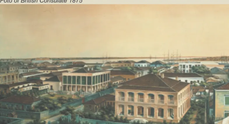
Foto of British Consulate 1875
Architectural styles not only indicate the forms of buildings but also refer to the variety of cultures, regiones and histo-ries etc. It is influenced by the politics, society, economy and material technology of different times. The group of build-ings on the Bund is evidently like the World’s Fairs of archi-tectural styles.
The architectural styles of the buildings on the Bund are changed in response to the economic development and ethos, which are represented the most obviously in the process of style to Neo-classic style and to Eclectic style. Since Shanghai became the commercial port in1843. The architectural styles on the Bund have changed three times and finally turned to the present style.
建筑风格不仅仅是指建筑的形式,同时涉及文化差异、地域差 异等,在不同的时代会受到政治、社会、经济和建筑技术的影响。 外滩建筑群就是一个明显的万国建筑风格的博览会。 在上海近代建筑的转型中,从早期的殖民地外廊式建筑到西方 古典风格的转变 ,再到折衷主义、新古典主义、装饰艺术派的建筑 风格,这一切在外滩表现得最为明显。从1843年上海开埠以来,外 滩建筑经历了三次变迁,最终形成现在的风格。 2.1.1 建筑风格2.1.1 Architectural styles 51
The building in “Colonial Veranda Style” were actu-ally the combination and compromise of buildings in European and Local Colonial style, which appeared earlier in the tropical and subtropical British Colo-nies, for example, in Ameerica, Africa and Australia etc.
“Veranda style” was their typical characters.The architectural style on the Bund at that time was merely the copy of this “Colonial Veranda Style” style.
The colonizers earlier made drawings by them-selves and only local materials, the buildings are very simply and almost no difference in style. The typical types of buildings had office space on the lower floor and bedroom space on the upper floor, with veranda outside the rooms, and surrounded by a large open space, in general the whole space was not carefully arranged. But later it was influenced by the western local architecture, Classical and lavish decorative ambience was applied gradually to the simple Veranda style.
“殖民地外廊式”建筑实际上是欧洲建筑与殖民地地 方建筑的融合和折衷,最早出现在热带与亚热带的英国殖 民地,如南亚、非洲、澳大利亚等,外廊是其主要特征。 思南公馆宴会厅: 保存完好的老上海外廊式联 体住宅建筑外貌
Sinan mansion banquet hall: Well-preserved old
Shanghai corridor conjoined residential building
Colonial Veranda Style 外廊式建筑
The external form is designed in a Renascence style of British Victorian period, typical East Indian Veranda style. The veranda is inside the walls while the rooms are inside the veranda, the function is that it could be warm in winter and cool in summer. The central composition of the facade is the contin-uous arches,there are five semi-circular arches at the centre of the first floor, and the flat arches on either of them, the flat arches are at the centre of the second floor, and semi-circular arches are beside them. The roof is a hip roof, and Chinese butterfly shaped tiles are used, the walls are faced with red bricks. According to the characters of the low-lying land on the Bund, designers constructed a taller basement. The Consulate Building is in the centre of the big lawn, and surrounded by green trees, it appears very elegant and beautiful.
British Consulate Building
British Consulate Building 1872 33, Zhongdshan East No.1 Rd.
英国领事馆 中山东一路,33号
建造时间:1872
Construction Time:1872
建筑师:格罗斯曼和鲍伊斯
Architect:Grossman and Beuys
层数:2 Number of floor:2 结构:砖木结构 Structure:Brick-wood structure 建筑外形具有英国维多利亚时期的文艺复兴风格,也 是典型的外廊式建筑。外墙内有宽敞的游廊,内测才是房 间,居室因而有冬暖夏凉的作用。建筑立面以连续的券廊 为构图特征,底层中部为五孔券廊,两侧为平券,二层中 间为平券,两侧为拱券。屋顶为四坡顶,使用中国蝴蝶, 墙面用清水砖墙。根据外滩地势低的特点,设计师做了较 高的台基。领事馆位于一英式庭院的中央,建筑被绿树环 绕,显得典雅秀丽。 53
The map of the British Consulate
The foto of the British Consulate
Merchants Steam Navigation Building
Merchants Building in history 9, Zhongdshan East No.1 Rd.
轮船招商局大楼 中山东一路,9号
建造时间:1901
Construction Time:1901
建筑师:玛礼逊洋行
Architect:Morrison , G.James
层数:3
Number of floor:3
结构:砖木结构
Structure:Brick-wood structure
9, Zhongshan East No.1 Road on the Bund is formerly the office of American Russell&Co.and was purchased by Merchants Bureau founded by Li Hongzhang after 1867. The new building is built in 1901, designed by Morrison, G.James, the floor area is 1460 sqm, it is a three-storied and a brick and wood structure building.
Merchants Steam Navigation Building is the only building in Colonial Veranda style of British Post Victoria times on the Bund. There are obviously cornices between each story and the outer wall on the first floor is masonry. Both sides of the main door are blanked by Corinthian orders. Other doors and windows are all semi-circular arches. The second and third floors of the east facade faced to the Bund were decorated by Tuscan and Corinthian orders before. The material of outer wall is red gran-ite,the basement, cornice and the roof is construct-ed by blue bricks.Both the roofs of south and north sides on the facade to the east are gable walls in British Classic Revival style.
外滩中山东一路9号旧址原来是美商旗昌洋行所在。 1877年被李鸿章创办的招商局收购。新大楼建于1901, 由英商玛礼逊洋行设计,建筑面积1460平方米,是一幢 高三层的砖木结构建筑。 轮船招商总局大楼时外滩建筑群中惟一一座英国瞧着 王朝摄政时期的北美殖民地风格建筑。各层间都有明显的 腰线,底层是石砌的外墙。正门两侧装饰有柯林斯柱。门 和窗均为拱形。朝向外滩的东立面二至三层前装饰有塔斯 干和柯林斯柱式的敞廊。外墙采用红色花岗岩石料,基、 檐口及屋顶部分使用青石。东面南北两翼屋顶为英国古典 复兴风格的山花。 55
The plane of the main body is over fifteen meters wide, and the building is supported by 8 steel columns and outer brick walls. The internal stair-case is curved with a delicate carved wooden hand-rail and balustrade. The basic structure of the floors is a wood beam with flooring board.
主体平面为五开间,内用八根钢柱与外圈砖墙承重。 内部楼梯结构曲折,木扶手和栏杆雕花都十分精致。楼层 基本结构为木梁,地坪也为木地板。
The facade of the Merchants Steam Navigation Building Details of the facade ofthe Merchants Steam
Neo-classicism movement started in the late 18th century,and attempted to establish a rational Clas-sic Law, to create a rational prototype and ideal architecture.The rational Classic architectural proto-type is to persuit philosophic structure and aesthetic fact,and the most faithful for the classic law.
Among the buildings on the Bund in Shanghai, the western Neo-classic style has become a leading architectural style,and has the same Classic archi-tectural language with European Neo-classic style of the 19th century.After the second opium war, with expansion of the lease, the western colonizers leaded by Briton started a reconstruction boom on the Bund, so the architectural style which was very popular in Europe at that time was introduced into the Bund. 新古典主义运动开始于18世纪下半叶,这一运动试图 改变巴洛克和洛可可艺术的繁文缛节,重新建立理性的古 典法则,创造理性的古典建筑原形追求在哲学上的结构和 审美的真实,及对古典法则的最高忠实。 在上海外滩的建筑中,从1870年代开始,各种各样的 西方古典复兴形式逐渐成为主导的建筑风格,这些建筑与 19世纪的欧洲新古典主义建筑有着共同的建筑语言。以后 随着上海租界财力的增加,以英国人为首的西方商人,开 始大规模翻造外滩地段的建筑,将当时欧洲流行的建筑形 式——引入。 沙美银行大楼 Historic Site Building
Neo-classical and Renaissance Style 新古典主义和文艺复兴风格
From 1870s-1920s, the buildings on the Bund was rapidly changed from the buildings in early Colonial style to the buildings in Post Colonial style, and replaced gradually by the buildings in European Neoclassic style. It mainly represented a late British Victoria style, Queen Annie Revival style and Eclec-ticism style.
In this period, because of the rapid development of the real estate industry and the introduction of the new materials, such as the cement, nearly half of the Bund buildings were rebuilt. The main structures of the buildings are changed from brick-wood struc-tures to the reinforced concrete strucstruc-tures, also the number of floors are increased, generally 3 to 6.
主要为英国维多利亚时代晚期的建筑样式和安妮女王 复兴风格及折衷主义。至1920年代,外滩新建的建筑逐 渐采用欧洲新古典主义。 这一时期,随着房产业的迅速发展和新材料的引,比 如水泥。外滩几乎一半的建筑都是由水泥建造的。主要结 构由砖木结构向混凝土转变。建筑楼层也在增高,变成 3-6层。
Asiatic Building
Asiatic Building 1916 1, Zhongdshan East No.1 Rd.
亚细亚大楼 中山东一路,1号
建造时间:1916
Construction Time:1916
建筑师:马海洋行
Architect:Moorhead & Halse
层数:7
Number of floor:7
结构:混凝土结构
Structure:Reinforced concrete
Asiatic Building was designed by Moor-head&Halse,and built by Yu Changtai Construction Co., it is a 7-storied building and reinforced concrete structure, the floor area 11984 sq m and total land surface 1739 sq m.It represents the Eclectic style, for various architectural styles and details are applied to the building.The front facade is in Baroque style, 4 Ionic orders blank at the main door, with the two of them on each side. Some small Ionic orders also flank the inner door, the lintel of the main door is decorated in Baroque style. The façade to the east and the south is arranged asymmetrically with the main door as an axis,by three horizontal and vertical sections. The section from the third to the fifth floors is precessed behind balconies with semi-circular steel balustrades. It is also decorated by Ionic orders on the upper five stories. The build-ing the represents a Neo-classic style and mixes a classic Barque style into it as well is completely a new attempt. 中山东一路1号曾经是英商亚细亚火油公司所在地,人 称“外滩第一楼”,是因它建成于1916年,是当时外滩最 高的一幢建筑。 亚细亚大楼由马海洋行设计,裕昌泰营造厂施工,钢 筋混凝土框架结构,占地面积1739平方米,建筑面积 11984平方米,高7层。建筑呈现折衷主义的风格,融入了 多种建筑文化元素。正立面为巴洛克式,主入口两侧爱奥 尼双柱,内门又有小爱奥尼柱,门楣处以变形的巴洛克涡 旋图案为装饰,入口处又有装饰,充分显示出巴洛克艺术 的繁复。以建筑转角处中轴线,东、南两立面形成对称, 均为横三段、竖三段式构图,三至五层凹进部分有阳台, 半圆形铁栏,五层以上又有爱奥尼柱装饰。建筑体现出华 丽的商业风格是一种全新的尝试。 59
Shanghai Club Building
Shanghai Club Building 1910 2, Zhongdshan East No.1 Rd.
上海总会大楼 中山东一路,2号 建造时间:1910 Construction Time:1910 建筑师:塔兰特 Architect:H.Tarrant 层数:5 Number of floor:5 结构:混凝土结构
Structure:Reinforced concrete
Shanghai Club is also called British Club,the pres-ent Shanghai Club Building was completed in 1910, and designed by H.Tarrant who was the member of the Society of British Royal Architects, it is the earli-est building which is a reinforced concrete skeleton structure in Shanghai. Five stories are on the ground and one story is underground, with 1800 sq m total land surface and 9280 sq m floor area. The external appearance represents a British Clas-sic style, built its decoration has Baroque charac-ters. The whole building is divided into three sections, and arranged symmetrically with the main door as an axis. The two decorative Tuscan orders flank the side entrances on both sides of the main door.6 Classic columns in Iontic style on the central section are running through the third and the fourth floors,so they are the visual center of facade, it is a kind of traditional methodology. There are delicate relief ornaments on the eaves of the second and the third floors. The sightseeing towers with semi-circu-lar arches in Baroque style are built at the north and south corners on top of the building, thus the build-ing appears taller and more magnificent. A stereo-scopic effect is created by using the Mansard roof.
上海总会又称英国总会,现存的伤害总会大楼建设完 成于1910年,由英国皇家建筑师学会会员——塔兰特设 计,是上海较早的钢筋混凝土框架结构的建筑。建筑地上 5层,地下1层,占地1800平方米,建筑面积9280平方。 大楼外观呈英国古典风格,带有许多巴洛克风格的装 饰细节。整个建筑分为三段式,以主入口为纵轴线,左右 严格对称。两侧的辅助入口通往底层,各有一对塔斯干立 柱作为装饰,三、四层中部有通贯两层的六根爱奥尼立, 采用复古主义形式,构成立面的视觉中心,左右方壁柱上 方有精美的花饰浮雕。顶层南北两侧建有巴洛克风格的半 圆券额式塔亭,使建筑更加显得气势宏伟、高大。屋面采 用变形的孟莎式屋顶,增强了建筑的立体视觉效果。 61
The granite stairs from the main entrance of the Shanghai Club lead to the hall,8 Ionic orders 17.9 feet high are on the both sides of the hall, the round orders support the lintel and arches. The ceiling is arch shaped glasses.
上海总会的主入口由花岗岩台阶引至大厅。大厅两侧 有八对高约5.5米的爱奥尼圆柱,圆柱支持着楣构和拱。 顶部是拱形玻璃天棚。
Union Building
Union Building 1916
3, Zhongdshan East No.1 Rd.
有利大楼 中山东一路,3号 建造时间:1916 Construction Time:1916 建筑师:公和洋行 Architect:Palmer&Turner 层数:6 Number of floor:6 结构:钢框架结构
Structure:steel skeleton
Union Building is a rebuilt office building on the old place of Adamson & Bell. The present building was rebuilt in 1916. The former three storied brick and wood structure building was replaced by a 6-stories building. The English name is “Union Build-ing”sometimes it is translated as “LIAO BAO DA LOU”, but generally as “LIAN HE DA LOU”in chinese.
The reconstructed building which is the first building designed by Palmer&Turner in Shanghai is very remarkable, it is also the first building of a steel skeleton structure,occupied 2241 sq m, the floor area is 13760 sq m. It was “the largest and the high-est building in the newhigh-est style, and the equipment used in the building was the most advanced on the Bund”at that time. The lot for construction is teape-zoid,the short side to the east is only about 30 meters and the long side to the north is about 70 meters, the facade to the Bund is also a main facade,and therefore the building has two main facades. The designer Mr.Morrison has applied the Electicism design method to the building, which is 6 stories. 有利大楼是在原来天祥洋行旧址上于1916年新建的 办公大楼,按英文名称直译为“联合大楼”或因投资方联 合保险公司而意译为“联保大楼”,后又因英资有利银行 长期入驻,通常称为“有利大楼”。 有利大楼时公和洋行在上海设计的第一个作品,也是 上海第一座采用钢框架结构的建筑,占地面积为2241平 方米,建筑面积为13760平方米。在当时,也是外滩规模 最大、楼层最高、样式最新、设施最先进”的建筑。由于 建筑基地呈梯形,朝东只有30余米,朝北约有70米,因 此,大楼有东面和北面两个主要立面,转角处设置的塔楼 则正好形成建筑的视觉焦点。建筑师威尔逊整体上采用了 折衷主义的设计手法,建筑高6层. 63