SCUOLA DOTTORALE IN GEOLOGIA DELL’AMBIENTE E DELLE RISORSE
(SDiGAR)
CORSO DI FORMAZIONE DOTTORALE IN GEOLOGIA DELL’AMBIENTE E
GEODINAMICA
CICLO XXVII
THE UPLIFT OF THE ETHIOPIAN PLATEAU
PhD candidate:
Andrea Sembroni
_______________________
Supervisor:
Prof. Claudio Faccenna
_______________________
Co-Supervisor:
Dr. Paola Molin
_______________________
PhD coordinator:
- 1 -
- 2 -
“To exist in this vast universe for a speck of time is the great gift of life. Our tiny sliver of time is our gift of life. It is our only life. The universe will go on, indifferent to our brief existence, but while we are here we touch not just part of that vastness, but also the lives around us. Life is the gift each of us has been given. Each life is our own and no one else's. It is precious beyond all counting. It is the greatest value we can have. Cherish it for what it truly is... Your life is yours alone. Rise up and live it.”
- 3 -
Index
Abstract
………...5Preface
...………..9Chapter 1 – Structure of the Continental Flood Basalts in the Ethiopian Plateau
1.1 Introduction………..20 1.2 Geological setting………..22 1.3 Topography………...23 1.4 Methods ………..26 1.5 Results ………..29 1.6 Discussion………...341.6.1 Geologic evolution of the Ethiopian Plateau since Triassic………...36
1.7 Conclusions………...40
References………...44
Chapter 2 – The influence of deep and surface processes on the evolution of
drainage systems: the example of the Ethiopian Plateau
2.1 Introduction……….522.2 Geological setting……….53
2.3 Geomorphology……….56
2.4 Methods and Results……….58
2.4.1 Topography analysis………..58
2.4.1.1 Local relief distribution in the Ethiopian Plateau……….60
2.4.1.2 Swath profiles………61
2.4.1.3 Filtered topography………..63
2.4.2 Drainage network analysis………..64
2.4.2.1 Hypsometry………64
2.4.2.1.1 Blue Nile R. basin………..65
2.4.2.1.2 Tekeze R. basin………67
2.4.2.2 Stream longitudinal profiles………69
2.4.2.2.1 Blue Nile R. basin………..71
2.4.2.2.2 Tekeze R. basin………73
2.4.2.2.3 ksn vs local relief analysis...76
2.4.3 Maps of the along-channel variation in ksn………..76
2.4.4 Knickpoint celerity model……….79
2.5 Discussion……….83
2.6 Conclusions………..88
- 4 -
Chapter 3 – Long term dynamic support of the Ethiopian Swell
3.1 Introduction……….100
3.2 Geological setting……….101
3.3 Reconstructing topographic evolution………..104
3.1 Flexural isostasy………104
3.1.1 Flexural uplift of rift shoulder………104
3.1.2 Flexural uplift of Tana escarpment……….108
3.2 Basalts loading and erosional unloading………....110
3.3 Pre-Trap topography………....113
3.4 Residual topography………....115
3.5 Dynamic topography………....115
3.4 Discussion………..117
3.4.1 Considerations on pre-Trap topography………....118
3.4.2 Uplift pattern evolution...………...121
3.5 Conclusions………..123
References………....124
General conclusions
………..133- 5 -
Abstract
The topographic configuration of the Earth's surface is the result of the interaction between deep and surface processes. The surface subsides above mantle downwellings and rises up above mantle upwellings forming dynamic topography. Similarly erosion and crustal thickening drive the mean topography to lower and raise respectively because of isostasy. So, in order to reconstruct the topographic evolution of a certain area, it is necessary to distinguish the several components of topography. In this respect, Africa is a perfect natural laboratory to examine the relationships between surface deformation, lithospheric structures and the underlying convecting interior. In particular Ethiopia has long been recognized as an ideal location to study rifting and hot spot tectonism. However, despite all the studies carried out, no consensus exists on several geologic aspects like the timing and pattern of rock uplift, the evolution of the drainage system and the interpretation of deep seismic data.
In this thesis the geologic and geomorphologic features of the Ethiopian Plateau have been analyzed in order to reconstruct the topographic evolution of the area since Oligocene.
The Ethiopian Plateau is located in the northwest of Ethiopia. It is characterized by up to 2 km thick Oligocene continental flood basalts (CFB) related to the Afar plume activity. Such volcanics deposited on an alternation of Mesozoic sandstones and limestones and on a Paleozoic/Precambrian basement. The plateau is bordered by the Main Ethiopian Rift/Afar escarpment to the east and by the Tana escarpment to the west. The drainage system is characterized by the Blue Nile and Tekeze rivers basins.
Here, a multidisciplinary approach has been used combining analytic models, GIS-based analysis, and field work. To characterize the plateau drainage system a quantitative geomorphologic analysis has been performed. The CFB thickness and the amount of the eroded materials have been quantified in order to determine the basalts loading and the erosional unloading. The flexural uplift at the rift and Tana escarpments have been modeled. By subtracting all the isostatic contributions from the present CFB base surface the Oligocene topography has been obtained. Using recent seismic data and crustal models, new residual and dynamic topographies have been elaborated and compared with the pre-CFB one.
The CFB geometry analysis shows a rough CFB base surface and an asymmetric basalts distribution respect to the Rift Valley. The thickest deposits concentrate in the Lake Tana region which represented one of the main basalts source areas.
- 6 -
The morphometric analysis evidences that the Tekeze and Blue Nile drainages have followed divergent pathways of incision. In particular the Tekeze R. seems to be responding in a more or less steady way to a single, early base level fall whereas the Blue Nile R. is responding in an unsteady way to multiple base level falls that may be both external and internal to the plateau in origin.
The regional topographic analysis shows that a dome-shaped feature centered on Addis Ababa is present in both the pre- and post-CFB topography, consistent with the notion that the region has experienced dynamic support since the Oligocene.
- 7 -
Riassunto
La configurazione topografica della superficie terrestre è frutto dell’interazione tra processi superficiali e profondi. In corrispondenza di flussi mantellici discendenti la superficie subisce subsidenza mentre in presenza di flussi mantellici ascendenti si verifica sollevamento. La topografia formata in seguito a tali processi viene definita dinamica. Allo stesso modo l’erosione e l’ispessimento crostale producono rispettivamente l’abbassamento e il sollevamento della topografia media a causa dell’isostasia. Per ricostruire l’evoluzione topografica di una determinata area, è necessario quindi distinguere le diverse componenti della topografia. L’Africa è un laboratorio naturale perfetto per esaminare le relazioni tra la deformazione superficiale, le strutture litosferiche e la convezione mantellica. In particolare l’Etiopia viene considerata da lungo tempo la regione ideale per studiare i processi di rifting e la tettonica legata alla presenza di un punto caldo. Tuttavia, nonostante i numerosi studi effettuati nell’area, sono ancora numerosi gli aspetti geologici dibattuti come ad esempio l’evoluzione temporale e spaziale del sollevamento tettonico, l’evoluzione del drenaggio e l’interpretazione dei dati sismici.
Nella presente tesi sono state analizzate le caratteristiche geologiche e geomorfologiche del plateau etiopico allo scopo di ricostruire l’evoluzione topografica dell’area a partire dall’Oligocene. Il plateau etiopico si trova nel settore nord-occidentale dell’Etiopia ed è formato da basalti continentali oligocenici (CFB) legati all’attività del plume dell’Afar. Tali vulcaniti si sono depositate su un’alternanza di calcari e arenarie mesozoiche e su un basamento cristallino caratterizzato da sedimenti glaciali paleozoici e rocce metamorfiche precambriche. Il plateau è delimitato ad est dalla scarpata del Rift etiopico e ad ovest dalla scarpata del Tana. Il sistema di drenaggio è costituito dai bacini idrografici dei fiumi Nilo Blu e Tekeze.
Questo lavoro segue un approccio multidisciplinare combinando modelli analitici, analisi in ambiente GIS e indagini di terreno. Per caratterizzare il sistema di drenaggio del plateau è stata realizzata un’analisi geomorfologica quantitativa. Sono stati calcolati gli spessori dei CFB e del materiale eroso allo scopo di determinare i contributi isostatici dovuti al carico dei basalti e allo scarico erosivo. Sono stati modellati i sollevamenti flessurali lungo le scarpate del Rift e del Tana. In seguito, sottraendo tutti i contributi isostatici dalla superficie di base dei CFB, si è ricostruita la topografia oligocenica dell’area di studio. Tale superficie è stata poi confrontata con le attuali topografie residua e dinamica elaborate utilizzando dati sismici e modelli crostali recenti.
- 8 -
L’analisi della geometria dei CFB mostra una superficie di base irregolare ed una distribuzione asimmetrica dei basalti rispetto al Rift etiopico. I depositi più spessi si concentrano nella regione del Lago Tana che rappresenta una delle maggiori aree sorgenti di CFB nell'area.
L’analisi morfometrica evidenzia che i bacini dei fiumi Tekeze e Nilo Blu hanno subito diversi percorsi evolutivi. In particolare il Fiume Tekeze presenta i caratteri morfometrici di un fiume prossimo all'equilibrio e sembra rispondere ad un unico abbassamento del livello di base. Il Fiume Nilo Blu, invece, è in uno stato transiente di disequilibrio e si è evoluto in seguito a numerosi abbassamenti del livello di base causati da fattori sia interni che esterni al plateau.
L’analisi topografica regionale mostra lo stesso andamento a domo centrato nell’area di Addis Ababa sia nella topografia pre- che in quella post-CFB. Tale risultato indica che la regione è soggetta ad un supporto dinamico continuo dall’Oligocene al presente.
- 9 -
Preface
Earth's topography is the result of the competition between deep and surface processes (Molnar and England, 1990; Beaumont et al., 1992; Merritts and Ellis, 1994; Koons, 1995; Avouac and Burov, 1996; Whipple and Tucker, 1999; Molin et al., 2004; Wegmann et al., 2007; Molin et al., 2011; Babault and Van Den Driessche, 2012; Scotti et al., 2013).
The mantle convection drives dynamic upwellings and downwellings in the Earth's surface (Braun, 2010). The mantle flow is driven mostly by the descent of cold tectonic plates during subduction and by the ascent of mantle plumes (Braun, 2010; Allen, 2011). The Earth’s surface subsides above mantle downwellings and rises up above mantle upwellings to form the dynamic component of topography (Hager et al., 1985). The link between mantle flow and surface topographic features is not straightforward since it is difficult to isolate the dynamic component of topography from features generated by crustal, subcrustal, and surface processes (Allen, 2011). So to reconstruct the topographic evolution of a certain area, it is necessary to distinguish the several components of topography.
Africa is an perfect natural laboratory to examine relationships between surface deformation, lithospheric structure and the underlying convecting interior (Morgan, 1983; Pérez-Gussinyé, 2009). In particular Ethiopia has long been recognized as an ideal place to study rifting and hot spot tectonism (Ebinger and Casey, 2001; Nyblade and Langston, 2002; Furman et al., 2006; Bastow et al., 2008).
The Ethiopian Plateau
We focused our investigation on the topographic evolution of the Ethiopian Highlands, a highstanding plateau located in the northwestern sector of Ethiopia and bordered on the eastern side by the Main Ethiopian Rift (MER)/Afar escarpment and on the western side by the Tana escarpment. Much of the region lies above 2500 m a.s.l. and comprises extensive areas of nearly flat landscape. It is drained by two major rivers: the Blue Nile and Tekeze rivers.
The area is covered by 1-2 km thick basalts deposited mainly between 30 and 28 Ma (Mohr and Zanettin, 1988; Zumbo et al., 1995; Baker et al., 1996a; Hofmann et al., 1997; Rochette et al., 1998; Pik et al., 2003; Kieffer et al., 2004). These volcanic sequences together with Mesozoic/Paleozoic sediments and metamorphic rocks reach 2 to 5 km of thickness (Mackenzie et al., 2005).
- 10 -
Such area is part of a wide region of anomalously high topography extending from the southeastern sector of the Atlantic Ocean up to the East Africa (Africa Superswell; Nyblade and Robinson, 1994). In fact, much of the African continent stands above 1 km contrasting with the 600 m mean elevation of the other continental areas (Babault and Van Den Driessche, 2012).
Plateau uplift: an unsolved problem
The Ethiopian Plateau has experienced up to ~2 km of rock uplift since ~30 Ma (Pik et al., 2003; Gani et al., 2007). Dainelli (1943) and Beydoun (1960) suggested this uplift to be Upper Eocene in age preceding flood basalts eruption and rifting. Successively, several authors (Mohr, 1967; Baker et al., 1972; McDougall et al., 1975; Merla et al., 1979; Berhe et al., 1987) argued against this theory and hypothesized a more complex history of uplift and volcanism.
Pik et al. (2003), based on thermochronological data, suggested that the elevated plateau physiography existed since the Oligocene (20–30 Ma).
Conversely, a more recent analysis based on the incision of the 1.6 km deep Gorge of the Nile (Gani et al., 2007), argued for a different evolution. They suggested that the uplift of ~2 km occurred episodically in three phases since ca. 29 Ma: a slow and steady uplift rate, between ~29 and ~10 Ma (phase I), that increased at ~10 Ma (phase II) and more dramatically at ~6 Ma (phase III). According to this model, most of rock uplift occurred after 6 Ma, in accordance with Mohr (1967), Baker et al. (1972), McDougall et al. (1975), Almond (1986), Adamson and Williams (1987). Ismail and Abdelsalam (2012) carried out a quantitative morphometric analysis on the Ethiopian Plateau drainage system. They found out the strong influence of the impinging of Afar plume, of the shield volcanoes build-up event, and of the rift-flank uplift on the western escarpments in the evolution of rivers network.
The influence of uplift on climate
The change in topographic configuration modified and presently influences the circulation of the atmosphere and climate (Manabe and Terpstra, 1974; Ruddiman and Kutzbach, 1989; Molnar and England, 1990; Molnar et al., 1993; Ruddiman and Prell, 1997).
In East Africa rainfall is related to the low tropospheric winds blowing northeasterly during boreal winter and southwesterly during boreal summer (Gatebe et al., 1999). Meridional moisture transport shows that Ethiopian highlands deflect the northeast monsoon flow southward along the Somalian coast during winter and that Kenyan highlands deflect the southeast flow northward during summer (Sepulchre et al., 2006).
- 11 -
By isotopic studies Cerling et al. (1997) have attributed an Upper Miocene (8 to 6 Ma) transition from woodlands to grasslands to atmospheric CO2 decrease. A later (5 to 3 Ma) spreading of grasslands was attributed to both Indian Ocean sea surface temperature cooling and the onset of glacial-interglacial cycles (Cane and Molnar, 2001; Bonnefille et al., 2004; Bobe and Behrensmeyer, 2004; deMenocal, 2004). Conversely Sepulchre et al. (2006) related these climate changes to uplift events using numerical models.
Mantle plume influence: evidences and open questions
Only a minor part of the total Ethiopian Plateau uplift seems to be related to isostatic processes (Corti, 2009). Several studies demonstrated that East Africa is characterized by a huge dynamic forcing originating in the deeper portion of the mantle (McKenzie and Weiss, 1975; Cox, 1989; Ebinger et al., 1989; Davies, 1998; Ebinger and Sleep, 1998; Ritsema et al., 1999; Gurnis et al., 2000; Şengör, 2001; Behn et al., 2004; Pik et al., 2006; Bastow et al., 2008; Moucha and Forte, 2011; Nyblade, 2011; Bagley and Nyblade, 2013; Faccenna et al., 2013).
Geochemical analysis of rift basalts, volcanic gases and geothermal fluids are consistent with a mantle plume influence (e.g., Hart et al., 1989; Schilling et al., 1992; Marty et al.,1996; Scarsi and Craig, 1996). No consensus exists on the number of mantle upwellings (e.g., Schilling et al., 1992; Ebinger and Sleep, 1998; George et al., 1998; Courtillot et al., 1999; Rogers et al., 2000; Kieffer et al., 2004; Furman et al., 2006; Rogers, 2006; Chang and Van der Lee, 2011). For example, Ebinger and Sleep (1998), suggested that just one large plume impinged the African lithosphere near Turkana at 45 Ma; then the lithosphere base topography funneled buoyant material up to 1000 km from Turkana to the Red Sea. Alternatively, George et al. (1998) and Rogers et al. (2000) proposed the existence of two Cenozoic plumes: one rising beneath southern Ethiopia at 45 Ma and another one impinging the base of the lithosphere beneath the Afar depression. Furman et al. (2006) invoked the idea of multiple plume stems rising from a deeper feature of the mantle (the African Superplume). Faccenna et al. (2013) reconstructed the patterns of mantle convection beneath the Afar–Anatolia–Aegean system evidencing a northward flow of the deep mantle Africa-Afar Plume driven by the Hellenic subduction. The same flow pattern has been observed also by Bagley and Nyblade (2013) and Hansen and Nyblade (2013).
The strong debate on the existence of such continuous hot mantle feature is due essentially to the intrinsic limitations of global tomography studies and on the dependence of seismic velocity on composition, phase and temperature of the mantle (Corti, 2009). Even admitting the existence of
- 12 -
this mantle upwelling, its connection with surface uplift, volcanism and rifting remains poorly defined (Corti, 2009).
Crustal structure
The crust beneath the Ethiopian Plateau has not been modified significantly by the Cenozoic rifting and magmatism (Corti, 2009). Indeed its thickness ranges between ~38 – 40 km (Kebede et al., 1996; Mackenzie et al., 2005; Dugda et al., 2005, 2007; Stuart et al., 2006; Keranen and Klemperer, 2008; Keranen et al., 2009) with a strong north–south decrease occurring at 9°N latitude (Yerer-Tullu volcano-tectonic lineament) where the western shoulder thins rapidly from ~38–40 km to 34–36 km (Dugda et al., 2005; Stuart et al., 2006; Dugda et al., 2007; Keranen and Klemperer, 2008; Keranen et al., 2009). In the Ethiopian plateau (northwest of latitude 9°N) there is a sharp transition to a thinner crust (of ~5 km) below the rift (Corti, 2009).
The Main Ethiopian Rift evolution
Based on geophysical observations, Keranen and Klemperer (2008) suggested that the Ethiopian and Somalian Plateaux correspond to two major Proterozoic basement terranes. Coincidence of the MER with the boundary between the terranes suggests that the location and evolution of the extensional process in the MER was strongly controlled by this ancient lithospheric-scale heterogeneity (Keranen and Klemperer, 2008).
Theoretical modelling (Tommasi and Vauchez, 2001) and studies carried out in other Large Igneous Provinces (Courtillot et al., 1999) demonstrate that the reactivation of the weakness zone occurs at the eastern edge of the upwelling mantle and not above its center.
The MER started to form in the Early Miocene (20–21 Ma) in the southern Ethiopia, following the northward propagation of the Kenya Rift-related deformation (e.g., Bonini et al., 2005). No major extensional deformation apparently affected the Central and Northern MER segments between 21 and 11 Ma (Corti, 2009 and references therein). The Africa – Arabia separation by the Red Sea and Gulf of Aden extensional system was active since about 30 Ma (e.g., Wolfenden et al., 2005). Deformation in the Northern MER started in the Late Miocene at ~11 Ma (Wolfenden et al., 2004). In the Central MER, recent analysis by Bonini et al. (2005) indicated that no major extensional faulting was active in the Late Miocene, as testified by the emplacement at 12 – 8 Ma of extensive basalts currently outcropping on both rift margins. According to this study, extensional deformation in the Central MER started at about 5 – 6 Ma, although WoldeGabriel et al. (1990) suggested an earlier development (8 – 10 Ma) of the boundary faults.
- 13 -
The diachronous development of the different MER segments has been interpreted in terms of different models of rift propagation (see Corti, 2009). The two end-members are Wolfenden et al. (2004) and Bonini et al. (2005). The first suggest an Early Miocene (~18 Ma) initiation of the MER-related deformation in southwestern Ethiopia, and a propagation northwards through the Central and Northern MER into the Afar depression after ~11 Ma. Bonini et al. (2005) argue for a Miocene-Present southwards rift propagation from the Afar depression, with deformation affecting the Northern MER in the Late Miocene, the Central MER in the Pliocene and the Southern MER during the Late Pliocene – Pleistocene. This process was triggered by the clockwise rotation of the Somalian Plate started around 10 Ma (Bonini et al., 2005).
The initial phases of continental rifting in the MER corresponded to the activation of the boundary faults (Corti, 2009). Such fault system developed diachronously along the rift between 11 and 6 Ma and has been active mostly until about 2 Ma (Corti, 2009). During the Early Pleistocene, most of the extension and the volcanic activity shifted from the boundary faults to the central axes of the rift (Ebinger, 2005; Corti, 2009).
Despite the wide literature on the study area, the geologic and geodynamic complexity of the region makes the Ethiopian Plateau evolution matter of debate. More specifically the discussion deals with the pattern and timing of rock uplift, the influence of uplift on climate, the formation and evolution of the rift system, the interpretation of deep seismic data, the interaction between deep and surface processes and, in particular, the evolution of the plateau drainage system.
The present thesis tries to clarify some of these debated topics in order to characterize the landscape evolution of the Ethiopian Plateau. More specifically the work aims to:
Reconstruct the structure of the Ethiopian Plateau continental flood basalts (CFB) by tracing the CFB base and top surfaces and quantifying the spatial variation in basalts thickness in order to locate the main CFB source area.
Study the coupling between deep and surface processes by performing a quantitative morphometric analysis on the topography and the river network of the study area.
Reconstruct the topography evolution of the region by separating and quantifying the isostatic and dynamic contributions to topography.
The thesis includes three chapters. Each chapter deals with a single aim. In particular: - The first one is about the structure of the Ethiopian Plateau continental flood basalt (CFB). - The second one focuses on the quantitative morphometric analysis of the Blue Nile and Tekeze rivers basins.
- 14 -
- The third chapter deals with the isostatic and dynamic contributions to topography in the Ethiopian Plateau region.
References
Adamson, D. & Williams, M.A.J. (1987) - "Geological setting of Pliocene rifting and deposition in the Afar Depression of Ethiopia" - Journal of Human Evolution 16, 597–610.
Allen, P.A. (2011) - "Surface impact of mantle processes" - Nature, 4, 498-499.
Almond, D.C. (1986) - "Geological evolution of the Afro-Arabian dome" - Tectonophysics 131, 301–332. Avouac. J.P. & Burov, E.B. (1996) - "Erosion as a driving mechanism of intracontinental mountain growth" - J. Geophys. Res., 101, 17747-17769.
Babault, J. & Van Den Driessche, J. (2012) - "Plateau uplift, regional warping, and subsidence" - In: Shroder, J. (Editor in Chief), Owen, L.A. (Ed.), Treatise on Geomorphology. Academic Press, San Diego, CA, vol. 5, pp 36.
Bagley, B. & Nyblade, A.A. (2013) - " Seismic anisotropy in eastern Africa, mantle flow, and the African plume" - Geophys. Res. Lett., vol. 40, pp. 1500-1505.
Baker, B.H., Mohr, P.A. & Williams, L.A.J. (1972) - "Geologyof the EasternRift System of Africa" - Geological Society of America Special Paper, vol. 136. 67 pp., Boulder Colorado.
Baker, J., Snee, L. & Menzies, M. (1996a) – “A brief Oligocene period of flood volcanism in Yemen” - Earth and Planetary Science Letters 138, 39–55.
Bastow, I.D., Nyblade, A.A., Stuart, G.W., Rooney, T.O. & Benoit, M.H. (2008) - "Upper mantle seismic structure beneath the Ethiopian hot spot: rifting at the edge of the African low-velocity anomaly" - Geochemistry, Geophysics, Geosystems 9, Q12022. doi:10.1029/2008GC002107.
Beaumont, C., Fullsack, P. & Hamilton, J. (1992) - "Erosional control of active compressional orogens" - In: "Thrust Tectonics" edited by K. R. McClay, pp. 19-31, Chapman and Hall, New York, 1992.
Behn, M.D., C.P. Conrad & P.G. Silver (2004) - "Detection of upper mantle flow associated with the African plume" - EPSL, 224, 259-274.
Berhe, S.M., Desta, B., Nicoletti, M. & Tefera, M. (1987) – “Geology, geochronology and geodynamic implications of the Cenozoic magmatic province in W and SE Ethiopia” - Journal of the Geological Society of London 144, 213–226.
Bobe, R. & Behrensmeyer, A.K. (2004) - "The expansion of grassland ecosystems in Africa in relation to mammalian evolution and the origin of the genus Homo" - Paleogeogr. Paleoclimatol. Paleoecol. 207, 399 Bonnefille, R., Potts, R., Chalie, F., Jolly, D. & Peyron, O. (2004) - "High-resolution vegetation and climate change associated with Pliocene Australopithecus afarensis" - Proc.Natl. Acad. Sci. U.S.A. 101, 12125-12129.
- 15 -
Beydoun, Z.R. (1960) - "Synopsis of the Geology of East Aden Protectorate" - XXI International Geological Congress, Copenhagen 21, 131–149.
Bonini, M., Corti, G., Innocenti, F., & Manetti, P. (2005) – “Evolution of the Main Ethiopian Rift in the frame of Afar and Kenya rifts propagation” - Tectonics, v. 24, doi: 10.1029/2004TC001680.
Braun, J. (2010) - “The many surface expressions of mantle dynamic” - Nature Geoscience 3, 825–833. Cane, M.A. & Molnar, P. (2001) - "Closing of the Indonesian seaway as a precursor to east African aridification around 3-4 , million years ago" - Nature, 411, 157-162.
Cerling, T.E., Harris, J.M., MacFadden, B.J., Leakey, M.G., Quade, J., Eisenmann V. & Ehleringer, J.R. (1997) - "Global vegetation change through the Miocene/Pliocene boundary" - Nature, 389, 153-158.
Chang, S-J & Van der Lee, S. (2011) - "Mantle plumes and associated flow beneath Arabia and East Africa" - EPSL, 302, 448-454.
Corti, G. (2009) – “Continental rift evolution: From rift initiation to incipient break-up in the Main Ethiopian Rift, East Africa” - Earth-Science Reviews, 96, 1–53.
Courtillot, V., Jaupart, C., Manighetti, I., Tapponnier, P. & Besse, J. (1999) - "On causal links between flood basalts and continental breakup" - EPSL, 166, 177–195.
Cox, K.G. (1989) - "The role of mantle plumes in the development of continental drainage patters" - Nature, 342, 873-877.
Dainelli, G. (1943) - "Geologia dell’Africa Orientale (3 vols. text, 1 vol. maps)" - R. Accad. Ital., Roma. Davies, G. (1998) - "A channelled plume under Africa" - Nature 395, 743.
deMenocal, P.B. (2004) - "African climate change and faunal evolution during the Pliocene-Pleistocene" - EPSL, vol. 220, pp. 3-24.
Dugda, M.T., Nyblade, A.A., Jordi, J., Langston, C.A., Ammon, C.J. & Simiyu, S. (2005) - "Crustal structure in Ethiopia and Kenya from receiver function analysis: implications for rift development in Eastern Africa" - J. Geophys. Res., 110 (B1), B01303. doi:10.1029/2004JB003065.
Dugda, M., Nyblade, A.A., Julia, J., 2007. "Thin lithosphere beneath the Ethiopian Plateau revealed by a joint inversion of Rayleigh Wave Group velocities and receiver functions" - Journal of Geophysical Research 112. doi:10.1029/2006JB004918.
Ebinger, C. J., T.D. Bechtel, D. W. Forsyth & C. O. Bowin (1989) – “Effective Elastic Thickness beneath the East African and Afar Plateaus and Dynamic compensation for the uplifts” - J. Geophys.Res., 94, 2883-2901. Ebinger, C. & Sleep, N.H. (1998) – “Cenozoic magmatism in central and east Africa resulting from impact of one large plume” - Nature 395, 788–791.
Ebinger, C.J. & Casey, M. (2001) - "Continental breakup in magmatic provinces: an Ethiopian example" - Geology 29, 527–530.
Ebinger, C. (2005) - "Continental breakup: the East African perspective" - Astronomy and Geophysics 46, 2.16–2.21.
- 16 -
Faccenna, C., Becker, T.W., Jolivet, L. & Keskin, M. (2013) - "Mantle convection in the Middle East: Reconciling Afar upwelling, Arabia indentation and Aegean trench rollback" - EPSL 375, 254-269.
Furman, T., Bryce, J., Rooney, T., Hanan, B., Yurgu, G. & Ayalew, D. (2006) - "Heads and tails: 30 million years of the Afar plume" - In: Yirgu, G., Ebinger, C.J., Maguire, P.K.H. (Eds.), The Afar Volcanic Province within the East African Rift System: Geological Society Special Publication, vol. 259, pp. 95–119.
Gani, N.D., Abdelsalam, M.G. & Gani, M.R. (2007) – “Blue Nile incision on the Ethiopian Plateau: pulsed plateau growth, Pliocene uplift, and hominin evolution” - GSA Today 17, 4–11.
Gatebe, C.K., Tyson, P.D., Annegarn, H., Piketh, S. & Helas, G. (1999) - "A seasonal air transport climatology for Kenya" - J. Geophys. Res., 104, 14237-14244.
George, R., Rogers, N. & Kelley, S. (1998) – “Earliest magmatism in Ethiopia: evidence for two mantle plumes in one flood basalt province” - Geology 26, 923–926.
Gurnis, M., Mitrovica, J.X., Ritsema, J. & van Heijst, H.J. (2000) – “Constraining mantle density structure using geological evidence of surface uplift rates: the case of the African Plume” - Geochemistry, Geophysics, Geosystems 1 1999GC000035.
Hager, B.H., Clayton, R.W., Richards, M.A., Comer, R.P. & Dziewonski, A.M. (1985) - "Lower mantle heterogeneity, dynamic topography and the geoid" - Nature, vol. 313, 541-545.
Hansen, S.E. & Nyblade, A.A. (2013) - "The deep seismic structure of the Ethiopia/Afar hotspot and the African plume" - Geophys. J. Int., doi: 10.1093/gji/ggt116.
Hart, W.K., Woldegabriel, G., Walter, R.C. & Mertzman, S.A. (1989) - "Basaltic volcanism in Ethiopia: constraints on continental rifting and mantle interactions" - J. Geophys. Res., 94, 7731–7748.
Hofmann, C., Courtillot, V., Feraud, G., Rochette, P., Yirgu, G., Ketefo, E. & Pik, R. (1997) – “Timing of the Ethiopian flood basalt event and implications for plume birth and global change” - Nature 389, 838–841. Ismail, E.H. & Abdelsalam, M.G. (2012) - "Morpho-tectonic analysis of the Tekeze River and the Blue Nile drainage systems on the Northwestern Plateau, Ethiopia" - J. Afric. Erth. Sc., 69, 34-47.
Kebede, F., Vuan, A., Mammo, T., Costa, G. & Panza, G.F. (1996) - "Shear wave velocity structure of Northern and North-eastern Ethiopia" - Acta Geodaetica et Geophysica, 31, 145–159.
Keranen, K. & Klemperer, S.L. (2008) - "Discontinuous and diachronous evolution of the Main Ethiopian Rift: implications for the development of continental rifts" - EPSL, 265, 96–111. doi:10.1016/j.epsl.2007.09.038. Keranen, K., Klemperer, S.L., Julia, J., Lawrence, J.L. & Nyblade, A. (2009) - "Low lower-crustal velocity across Ethiopia: is the Main Ethiopian Rift a narrow rift in a hot craton?" - Geochemistry, Geophysics, Geosystems 10, Q0AB01. doi:10.1029/2008GC002293.
Kieffer, B., Arndt, N., Lapierre, H., Bastien, F., Bosch, D., Pecher, A., Yirgu, G., Ayalew, D., Weis, D., Jerram, D.A., Keller, F., & Meugniot, C. (2004) – “Flood and shield basalts from Ethiopia: Magmas from the African Superswell” - Journal of Petrology, v. 45, 793–834, doi: 10.1093/petrology/egg112.
Koons, P.O. (1995) - "Modelling the topographic evolution of collisional mountain belts" - Invited paper: Annual Review of Earth and Planetary Sciences, 23, 375-408.
- 17 -
Mackenzie, G.D., Thybo,H. & Maguire, P.K.H. (2005) - "Crustal velocity structure across the Main Ethiopian Rift: results from two-dimensional wide-angle seismic modeling" - Geophysical Journal International 162, 994–1006.
Manabe, S. & Terpstra, T.B. (1974) - "The effects of mountains on the general circulation of the atmosphere as identified by numerical experiments" - J. Atmos. Sci., 31, 3–42.
Marty, B., Pik, R. & Gezahegn, Y. (1996) - "Helium isotopic variations in Ethiopian plume lavas: nature of magmatic sources and limit on lower mantle contribution" - EPSL, 144, 223–237.
McDougall, I., Morton,W.H. & William, M.A.J. (1975) – “Ages and rates of denudation of trap series basalts at the Blue Nile Gorge, Ethiopia” - Nature 254, 207–209.
McKenzie, D.P. & Weiss, N.O. (1975) - "Speculations on the thermal and tectonic history of the Earth" - Geophys. J. R. astr. Soc., 42, 131.
Merla, G., Abbate, E., Canuti, P., Sagri, M. & Tacconi, P. (1979) - "Geological map of Ethiopia and Somalia and comment with a map of major landforms (scale 1:2,000,000)" - Consiglio Nazionale delle Ricerche, Rome. 95.
Merritts, D. & Ellis, M. (1994) - "Introduction to special section on tectonics and topography" - J. Geophys. Res., 99: doi: 10.1029/94JB00810. issn: 0148-0227.
Mohr, P.A. (1967) – “The Ethiopian Rift System” - Bulletin of the Geophysical Observatory of Addis Ababa 11, 1–65.
Mohr, P., & Zanettin, B. (1988) – “The Ethiopian Flood Basalt Province” - In McDougall, J.D., ed., Continental Flood Basalts: Dordrecht, Netherlands, Kluwer Academic Publishers, 63–110.
Molin, P., Pazzaglia, F.J. & Dramis, F. (2004) - "Geomorphic expression of active tectonics in a rapidly deforming forearc, Sila Massif, Calabria, southern Italy" - American Journal of Science 304, 559–589.
Molin, P., Fubelli, G., Nocentini, M., Sperini, S., Ignat, P., Grecu, F. & Dramis, F. (2011) - "Interaction of mantle dynamics, crustal tectonics and surface processes in the topography of the Romanian Carpathians: A geomorphological approach" - Glob. Planet. Change, doi:10.1016/j.gloplacha.2011.05.005.
Molnar, P. & England, P. (1990) – “Late Cenozoic uplift of mountain ranges and global climate change: chicken or egg?” - Nature 346, 29 – 34.
Molnar, P. & England, P. & Martinod, J. (1993) – “Mantle dynamics, uplift of the Tibetan Plateau and the Indian Monsoon” – Reviews of Geophysics, 31, 357-396.
Morgan, P. (1983) - "Constraints on rift thermal processes from heat flow and uplift" - Tectonophysics, 94, 277-298.
Moucha, R. & Forte, A.M. (2011) – “Changes in African topography driven by mantle convection” – Nature Geosc. Let. DOI: 10.1038/NGEO1235.
Nyblade, A.A. & Robinson, S.W. (1994) - "The African superswell" - Geophys. Res. Lett. 21, 765–768.
Nyblade, A.A. & Langston, C.A. (2002) - "Broadband seismic experiments probe the East African rift" - EOS Transaction on American Geophysical Union 83, 405–408.
- 18 -
Nyblade, A.A. (2011) - "The upper-mantle low-velocity anomaly beneath Ethiopia, Kenya, and Tanzania: Constraints on the origin of the African superswell in eastern Africa and plate versus plume models of mantle dynamics" - Geol. Soc. Am., Special Paper 478.
Perez-Gussinye, M., Metois, M., Fernandez, M., Verges, J. & Lowry, A.R. (2009) – “Effective elastic thickness of Africa and its relationship to other prozie for lithospheric structure and surface tectonics” - Earth Planet. Sci. Lett., 287(1-2), 152-167.
Pik, R., Marty, B., Carignan, J. & Lave, J. (2003) – “Stability of Upper Nile drainage network (Ethiopia) deduces from (U–Th)/He thermochronometry: Implication of uplift and erosion of the Afar plume dome” - Earth and Planetary Science Letters, v. 215, 73–88, doi: 10.1016/S0012-821X(03)00457-6.
Pik, R., Marty, B. & Hilton, D.R. (2006) - "How many mantle plumes in Africa? The geochemical point of view" - Chemical Geology 226, 100–114. doi:10.1016/j.chemgeo.2005.09.016.
Ritsema, J., H. J. van Heijst & J. H. Woodhouse (1999) – “Complex shear wave velocity structure imaged beneath Africa and Iceland” - Science, 286, 1925–1928, doi:10.1126/science.286.5446.1925.
Rochette, P., Tamrat, E., Feraud, G., Pik., R., Courtillot, V., Ketefo, E., Coulon, C., Hoffmann, C., Vandamme, D. & Yirgu, G. (1998) - "Magnetostratigraphy and timing of the Oligocene Ethiopian traps" - EPSL, 164, 497-510.
Rogers, N., Macdonald, R., Fitton, J., George, R., Smith, R. & Barreiro, B. (2000) - "Two mantle plumes beneath the East African rift system: Sr, Nd and Pb isotope evidence from Kenya Rift basalts" - EPSL, 176, 387–400.
Rogers, N.W. (2006) - "Basaltic magmatism and the geodynamics of the East African Rift System" - In: Yirgu, G., Ebinger, C.J., Maguire, P.K.H. (Eds.), The Afar Volcanic Province within the East African Rift System: Geological Society Special Publication, vol. 259, pp. 77–93.
Ruddiman, W. F. & Kutzbach, J.E. (1989) - "Forcing of the late Cenozoic northern hemisphere climate by plateau uplift in southeast Asia and the American southwest" - J. Geophys. Res., 94, 18409–18427.
Ruddiman, W.F. & Prell, W.L. (1997) - "Introduction to the Uplift-Climate Connection" - Plenum Press, New York, NY.
Scarsi, P. & Craig, H. (1996) - "Helium isotope ratios in Ethiopian Rift basalts" - EPSL, 144, 505–516.
Schilling, J.G., Kingsley, R.H., Hanan, B.B. & McCully, B.L. (1992) – “Nd–Sr–Pb isotopic variations along the Gulf of Aden: evidence for Afar mantle plume-continental lithosphere interaction” - Journal of Geophysical Research B 97 (7), 10,927–10,966.
Scotti, V.N., Molin, P., Faccenna, C., Soligo, M. & Casas-Sainz, A. (2013) - "The influence of surface and tectonic processes on landscape evolution of the Iberian Chain (Spain): Quantitative geomorphological analysis and geochronology" - Geomorphology, http://dx.doi.org/10.1016/j.geomorph.2013.09.017.
Şengör, A.M.C. (2001) – “Elevation as indicator of mantle-plume activity” - In Ernst, R.E., and Buchan, K.L., eds., Mantle Plumes: Their identification through time: Geological Society of America Special Paper 352, 183–225.
Sepulchre, P., Ramstein, G., Fluteau, F., Schuster, M., Tiercelin, J-J & Brunet, M. (2006) - "Tectonic Uplift and Eastern Africa Aridification" - Science, 313, 1419-1423.
- 19 -
Stuart, G.W., Bastow, I.D. & Ebinger, C.J. (2006) - "Crustal structure of the northern Main Ethiopian Rift from receiver function studies" - In: Yirgu, G., Ebinger, C.J., Maguire, P.K.H. (Eds.), The Afar Volcanic Province within the East African Rift System: Geological Society Special Publication, vol. 259, pp. 253–267. Tommasi, A. & Vauchez, A. (2001) - "Continental rifting parallel to ancient collisional belts: an effect of the mechanical anisotropy of the lithospheric mantle" - EPSL, 185, 199–210.
Wegmann, K.W., Zurek, B.D., Regalla, C.A., Bilardello, D., Wollenberg, J.L., Kopczynski, S.E., Ziemann, J.M., Haight, S.L., Apgar, J.D., Zhao, C. & Pazzaglia, F.J. (2007) - "Position of the Snake River watershed divide as an indicator of geodynamic processes in the greater Yellowstone region, western North America" - Geosphere 3 (4), 272–281.
WoldeGabriel, G., Aronson, J.L. & Walter, R.C. (1990) - "Geology, geochronology, and rift basin development in the central sector of the Main Ethiopia Rift" - Geological Society of America Bulletin 102, 439–458.
Wolfenden, E., Yirgu, G., Ebinger, C., Deino, A. & Ayalew, D. (2004) – “Evolution of the northern Main Ethiopian rift: Birth of a triple junction” - Earth and Planetary Science Letters, v. 224, 213–228, doi: 10.1016/j.epsl.2004.04.022.
Wolfenden, E., Ebinger, C., Yirgu, G., Renne, P. & Kelley, S.P. (2005) – “Evolution of the southern Red Sea rift: birth of a magmatic margin” - Geological Society of America Bulletin 117, 846–864.
Whipple, K.X. & Tucker, G.E. (1999) - "Dynamics of the stream-power river incision model: implications for height limits of mountain ranges, landscape response timescales, and research needs" - Journal of Geophysical Research, vol. 104, 17661-17674.
Zumbo, V., Feraud, G., Bertrand, H., & Chazot, G. (1995) - "40Ar/39Ar chronology of the Tertiary magmatic activity in Southern Yemen during the early Red Sea-Aden rifting" - J. Volcanol. Geoth. Res. 65, 265–279.
- 20 -
CHAPTER 1*
STRUCTURE OF THE CONTINENTAL FLOOD BASALTS
IN THE ETHIOPIAN PLATEAU
1.1 Introduction
Continental flood basalt (CFB) or Trap provinces are the most spectacular examples of volcanic activity on the Earth surface (Bondre et al., 2004).
Geochronological studies (Courtillot et al., 1988; Dickin et al., 1988; Renne et al., 1991;1992; Baker et al., 1996; Duncan et al., 1997; Sinton et al., 1998; Marzoli et al., 1999; Ukstins et al., 2002; Jourdan et al., 2005; Chenet et al., 2007; He et al., 2007; Barry et al., 2010) point to a typical duration of 1 million years for the bulk of CFB eruption. The typical flux is of the order of or larger than 2 km3yr−1 (Courtillot and Renne, 2003). Such activity has been proved to be connected to mantle dynamics by isotope analysis (Campbell and Griffiths, 1990; Ellam et al., 1992; Sharma et al., 1992; Basu et al., 1993; 1995; Chung and Jahn, 1995; Marty et al., 1996; Quin et al., 2011). Another characteristic of CFB is their extreme lateral extent (Garner, 1996). The Pomona Member of the Saddle Mountains Basalt has a volume >600 km3 and can be traced for a linear distance of 600 km (Swanson and Wright, 1981).
The magmatic flux during Trap emplacement has the potential to induce global climatic change, through the massive input of ashes and gases in the upper stratosphere. This seems to be the case for the Deccan, Paraná, Central Atlantic and Siberian Traps, which are synchronous with the Cretaceous–Paleogene (K/T), Jurassic–Cretaceous (J-Cr), Triassic-Jurassic (Tr-J) and Permian– Triassic (P/T) boundaries respectively (Rochette et al., 1998). Estimates of the sulphur dioxide output for some of the Miocene Columbia River basalt flows are of the order of 1000 megatons per year, enough to produce conditions similar to those modeled for a nuclear winter (Hon and Pallister, 1995).
The Oligocene Ethiopian-Yemen CFB (Trap series) are located near the Afar triple junction and represent one of the youngest example of a major continental volcanic plateau. Because of their relatively young age and their eruption in a region where plate movements are slow, a complete record from the initial flood volcanic phase through to its shutdown and the onset of continental rifting, and finally the initiation of sea-floor spreading is preserved in the African Horn (Kieffer et al., 2004).
* This chapter will be submitted as: Sembroni, A., Faccenna, C. and Molin, P. (2015) - "Structure of the Continental Flood Basalts in the Ethiopian Plateau".
- 21 -
The deposits cover an area of 600000 km2 and not less than 750000 km2 before erosion, with a typical thickness varying from 500 to 2000 m (Berhe et al., 1987; Mohr and Zanettin, 1988). The total volume is estimated to be at least 350000 km3 (Mohr, 1983b; Mohr and Zanettin, 1988) and probably higher than 1200000 km3 according to Rochette et al. (1998). 40Ar/39Ar dating (Zumbo et al., 1995; Baker et al., 1996a; Hofmann et al., 1997; Rochette et al., 1998) indicates that most of the Trap series in Ethiopia and Yemen were extruded 30 Ma over a short time interval, possibly less than 2 Ma. According to the Trap volume calculated by Rochette et al. (1998) this time interval gives an eruption rate of 1 km3yr-1.
The chemical composition of the Ethiopian CFB supports a magma genesis from a broad region of mantle upwelling, heterogeneous in terms of temperature and composition (Kieffer et al., 2004). However no consensus exists on the number of mantle upwellings (Corti, 2009). Some works have proposed the existence of a single channeled plume (Ebinger and Sleep, 1998) or two starting plumes (George et al., 1998; Rogers, 2006; Montagner et al., 2007; Chang and Van der Lee, 2011) impinging the base of the lithosphere since Eocene time (Ebinger and Sleep, 1998; Şengör, 2001). The eruption of huge amount of basalts in such short time should have deeply changed the topographic configuration of the area as well as the initial structural and topographic pattern of the area should have influence location of the basalts vents. Understanding the basalts emplacement mode and localizing the main source area are fundamental steps in order to reconstruct the topography evolution of a Trap province. Moreover flood basalt eruptions are intimately associated with the initiation of rifted continental margins (Morgan, 1971; Mohr, 1983b; Richards et al., 1989; Campbell and Griffiths, 1990; Hooper, 1990; Hill, 1991; Griffiths and Campbell, 1991; Courtillot et al., 1999). In this respect Richards et al. (1989) suggest that rifting occurs shortly after Trap emplacement and that lithospheric thinning is not a prerequisite for CFB eruption (active rifting model). In contrast White and McKenzie (1989) assumed that rifts are primarily the result of regional stress distributions related to plate boundary forces and geometry, acting for instance on pre-existing zones of weakness either in the crust, or the mantle part of the lithosphere or both (passive rifting model). For all these reasons the study of Trap provinces and in particular of flood basalts is a powerful tool to understand the geodynamic evolution of a region. However in most of cases localizing the main CFB source area is not straightforward because of the huge thickness of the basalts pile which cover the pre-eruption topography. Despite the number of studies on the provenience, the age and the chemical composition of the Ethiopian Trap, limited efforts have been made to study the CFB geometry. Also the main site of Ethiopian CFB egress is still debated. According to Mohr (1983b) the "expected loci" of the most productive
- 22 -
fissure-feeders for the lavas are aligned along the MER and Afar margins where the crustal warping is maximum. Therefore the CFB eruption preceded the MER initiation and the basalts main source area coincides with the Rift location. However no quantitative data have been produced to justify such statement. Theoretical modelling (Tommasi and Vauchez, 2001) and studies carried out in other Large Igneous Provinces (Courtillot et al., 1999) demonstrated that the reactivation of the weakness zone occurs at the eastern edge of the upwelling mantle and not above its center. According to recent studies (Wolfeden et al., 2004; Bonini et al., 2005), the MER formed between 11 and 5 Ma, more than 20 Ma after the main Trap eruption phase (Zumbo et al., 1995; Baker et al., 1996a; Hofmann et al., 1997; Rochette et al., 1998). Moreover the spatial distribution of flood basalts in the region presents a marked asymmetry about the rift and Afar depression (Mohr, 1983b).
In this work we reconstruct the base and top surfaces of Trap deposits to trace the spatial variation of flood basalts and to quantify the thickness of CFB deposits. This allowed us to localize the main Trap source area and to investigate the relationships topography and basalts-MER. Our results coupled with literature data permitted us the trace the geologic evolution of the region since Triassic.
1.2 Geological setting
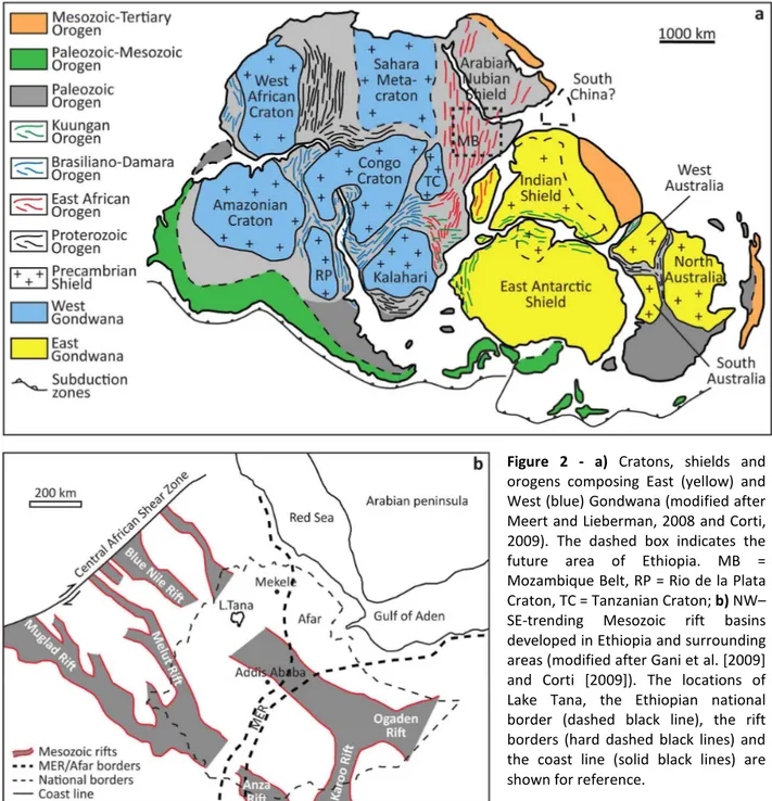
The basement of Ethiopia is characterized by folded and foliated pre-Cambrian rocks overlain by an alternation of sub-horizontal Mesozoic sandstones and limestones (Figs.1b, 2a-b). The basement rocks are part of the Arabian–Nubian Shield (northern sector of the East African Orogen) which is formed by collision between east and west Gondwana (Stern, 1994). Collision is marked by north-to east-trending sutures, characterized by low-grade volcano-sedimentary rocks and mafic-ultramafic rocks, sandwiched between medium- to high-grade gneisses and migmatites (Corti, 2009) (Fig.2a).
Such deformation was followed by a long period of widespread erosion in the Paleozoic, with the Precambrian orogenic mountain ranges almost completely worn down by denudation (Mohr, 1962).
Since Early Permian extensional deformation associated to Karoo-type rift occurred separating the Horn of Africa from Madagascar-Indian promontory (Guiraud et al., 2005). This episode was followed by the development of several NW–SE striking structural basins associated with the polyphase break-up of Gondwanaland (Blue Nile, Malut and Muglad rifts in Sudan and Anza graben in Southern Ethiopia and Northern Kenya; see Fig.2b); during the Mesozoic such
- 23 -
depressions served as depositional basins for continental sandstones and marine limestones (Plate 1a-b) (Chorowicz et al., 1998; Mege and Korme, 2004; Gani and Abdelsalam, 2006). These events were followed by local inversions and rift rejuvenation along these NW–SE striking basins up to the Paleogene (Corti, 2009).
During Eocene-Late Oligocene East Africa volcanism started with the eruption of the Ethiopian-Yemen flood basalts (Trap series; Fig.1b, Plate 1c-d) (Corti, 2009). These eruptions mostly occurred through fissures (Plate 2c-d; Mohr and Zanettin, 1988), at places controlled by pre-existing weaknesses inherited from the Precambrian (Mege and Korme, 2004). This phase of extensive eruption was concomitant with the onset of continental rifting in the Red Sea–Gulf of Aden systems by 29 Ma (Wolfenden et al., 2005), but predates the main rifting phases associated with the development of the Main Ethiopian Rift (MER; between 11 Ma [Wolfeden et al., 2004] and 5 Ma [Bonini et al., 2005]). Limited volumes of basalts as old as 45 Ma have been described in southern Ethiopia, in the area between MER and Kenya Rift (Davidson and Rex, 1980; Ebinger et al., 1993; George et al., 1998).
The outpouring of plateau basalts is associated with regional dynamic uplift (Ethiopian and Kenyan domes), attributed to the impinging of hot asthenospheric materials at the base of the lithosphere (Ebinger and Sleep,1998; Rogers, 2006; Yirgu et al., 2006). Immediately after the peak of flood basalt emplacement, a number of large shield volcanoes developed from 30 Ma to about 10 Ma on the surface of the basaltic plateau (Kieffer et al., 2004) (Fig.1b). Since late Pliocene to Present, magmatic and tectonic activities moved mainly into the axial sector of the MER and in the Afar depression (Ebinger, 2005; Corti, 2009). In this period the volcanic activity on the plateau was confined mainly in the southern and southeastern sectors of the Lake Tana area. Such activity was characterized by basaltic lava flows coming out from small volcanic cones located immediately south of the lake.
1.3 Topography
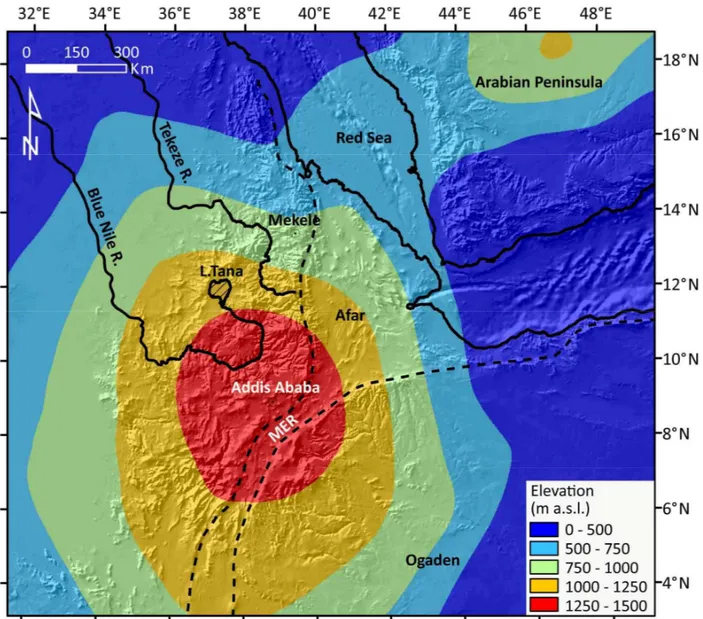
The Ethiopian plateau is located at the junction of three rifts: two oceanic rifts, Red Sea and Gulf of Aden, and the East African continental rift (Pik et al., 1998). It stands at a mean elevation of 2500 m a.s.l. with almost flat areas and huge volcanic reliefs which rise 1000-2000 m above the plateau surface (Mt. Ras Dashen 4620 m a.s.l.; Mt. Guna 4231 m a.s.l.; Mt. Abune Yosef 4190 m a.s.l.; Mt. Choke 4100 m a.s.l.; Mt. Guguftu 3975 m a.s.l.) (Fig.1a). It is bordered by two huge escarpments: the SSW-NNE trending Tana escarpment to the west and the N-S trending Afar-MER
- 24 -
Figure 1 - a) Topography of the Ethiopian Plateau area (ETOPO1 DEM with a resolution of around 2000 m). The black
box in the inset indicates the location of the study area and the Ethiopian national boundaries; b) geological map of the study area compiled from the 1:2.000.000 (Tefera et al., 1996) and the available 1:250.000 scale maps (Hailu, 1975; Kazmin, 1976; Garland, 1980; Tsige and Hailu, 2007; Chumburo, 2009; Zenebe and Mariam, 2011) of Ethiopia draped over the shaded topography.
- 25 -
escarpment to the east. These huge morphological features separate the high elevated plateau from the Sudan and Afar lowlands (Fig.1a).
The Tana escarpment presents a SSW-NNE trend and a total length of about 500 km from the Blue Nile lower course to the Simien Mts (Fig.1a). The escarpment takes its name from the Lake Tana located immediately east of it. The lake is thought to result from the damming of a 50-km-long Quaternary basalt flow, which filled the channel of the paleo-Blue Nile River to a possible depth of 100 m (Grabham and Black, 1925; Minucci, 1938b; Jepsen and Athearn, 1961; Mohr, 1962). The Tana basin lies at the convergence of three grabens: the Debre Tabor graben from the east, the Gondar graben from the north-northwest, and the Dengel Ber graben from the south-southwest (Chorowicz et al., 1998) . The grabens are buried in the mid-Tertiary flood basalt pile; the lack of
Figure 2 - a) Cratons, shields and
orogens composing East (yellow) and West (blue) Gondwana (modified after Meert and Lieberman, 2008 and Corti, 2009). The dashed box indicates the future area of Ethiopia. MB = Mozambique Belt, RP = Rio de la Plata Craton, TC = Tanzanian Craton; b) NW– SE-trending Mesozoic rift basins developed in Ethiopia and surrounding areas (modified after Gani et al. [2009] and Corti [2009]). The locations of Lake Tana, the Ethiopian national border (dashed black line), the rift borders (hard dashed black lines) and the coast line (solid black lines) are shown for reference.
- 26 -
exposure of the sub-volcanic terrain hides evidence for any earlier structural history (Zanettin, 1993; Chorowicz et al., 1998; Mege and Korme, 2004). The area is characterized by widespread dike and pipe feeders which contributed to the mid-Tertiary flood basalt flows of this sector of the Ethiopian Plateau (Mohr and Zanettin, 1988).
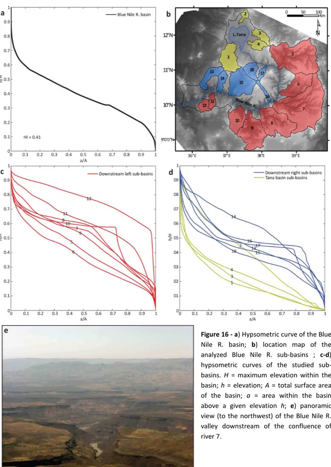
The plateau is carved by two main rivers: the Blue Nile R. and the Tekeze R. which drain respectively from south and north (Fig.1a). The present total Nile load is 230±20 x 106 t/a (Garzanti et al., 2006). Of such huge amount of detritus, 82±10 x 106 t/a are contributed by Atbara R. (Tekeze R.) and 140±20 x 106 t/a by the Blue Nile R. (Garzanti et al., 2006). The present erosion rates is estimated to be 0.05 mm/a (Garzanti et al., 2006). Pik et al. (2003), on the basis of partial resetting of apatite helium tracks, argue that the cutting of Blue Nile and Tekeze valleys commenced at 25–29 Ma. This follows uplift associated with eruption of the Afar Plume at 31 Ma and the formation of about 1 km of Ethiopian relief (Şengör 2001). Calculations of volumes eroded in the catchments of these two rivers have been made using the topographic envelope-subenvelope approach described in Molin et al. (2004). Pik et al. (2003) and Gani et al. (2007) have calculated an average erosion of 860 m, broadly in agreement with McDougall et al. (1975). The location of the sink for these volcanogenic sediments is controversial (Macgregor, 2012). The low pyroxene content in pre-Pliocene Nile delta sediments suggests that Ethiopia was not supplying sediment to the Nile delta area in the Miocene (Macgregor, 2012). Salama (1987; 1997) suggests that the Blue Nile basin in Sudan may have acted as a sink capturing Ethiopian-derived sediment and that the Blue Nile R. may have once drained to the Sudan Basin. Bonini et al. (2005) argued for 5 Ma as age for formation of the Ethiopian rift shoulders: this indicates that the majority of erosion should have been during the Plio-Pleistocene, when pyroxenes appeared in Nile R. sediments (Macgregor, 2012).
1.4 Methods
In order to study the geometry of the Ethiopian CFB deposits and the relationships flood basalts-topography and flood basalts-tectonics we analyzed the regional pattern of the basalts-topography and the geology of the Ethiopian Plateau area.
We investigated topography at regional scale adopting, as a digital data source, ETOPO1 global relief model (downloaded from http://www.ngdc.noaa.gov/) with a resolution of 1 arc-minute. We extracted, by MatLab topotoolbox (Schwanghart and Kuhn, 2010), four swath profiles choosing a 50 km wide observation window and sampling topography at an interval of 2 km. In order to catch the regional topographic features of the entire high-standing plateau and of the surrounding area,
- 27 -
we extracted the four swath profiles with different orientation (Fig.3a): profile 1 crosses the entire Ethiopian plateau following a NNW-SSE direction; profile 2, oriented NW-SE, is perpendicular to the MER; profile 3 trends W-E, transversally to the MER; profile 4, oriented SW-NE, is parallel to the MER and transverse to the Turkana and Afar rift systems.
For each cross section we calculated the trend of the maximum, minimum and mean elevation and the local relief. The maximum topography, obtained connecting peak elevations, displays topography without river incision (envelope surface). The minimum topography corresponds to the general pattern of valley bottom elevations (sub-envelope surface). The mean topography represents the general trend of landscape at regional scale. The local relief is the residual between the maximum and minimum topography and quantifies fluvial incision (Masek et al., 1994; Molin et al., 2004; Scotti et al., 2013).
We peformed the analysis of CFB geometry in an area including the Ethiopian and Somalian plateaux and the Yemen highlands. Such choice is strictly related to the accuracy of the source geological data. In fact the stratigraphic contacts in the plateau area have been mapped by 1:250.000 scale geological maps (Hailu, 1975; Kazmin, 1976; Garland, 1980; Tsige and Hailu, 2007; Chumburo, 2009; Zenebe and Mariam, 2011). On the contrary the Ethiopia-Sudan border area northwest of the plateau is covered just by the 1:2.000.000 scale geological map of Ethiopia (Tefera et al., 1996). For this reason, in order to reduce the interpolation error, we chose not to use data with too low accuracy, limiting the analysis only in the plateau area.
We assembled and operated all the data in GIS using ETOPO1 DEM as digital data source (http://www.ngdc.noaa.gov/). In particular we traced the flood basalts base mapping the contact with the sedimentary basement and interpolating points by a nearest-neighbor triangulation algorithm. Moreover in order to verify possible correlation between the Trap base surface configuration and tectonics we mapped tectonic lineaments and dikes in the Lake Tana region by applying a high-pass filter on the present topography (ETOPO1 DEM) and by using previous study structural data (Chorowicz et al., 1998; Mege and Korme, 2004). We reconstructed the flood basalts top surface by basaltic plateau remnants. They appear all over Ethiopia and Yemen highlands between an elevation of 2400 and 2600 m a.s.l. and consist of flat or gently sloping (1-2°) surfaces bounded by steep slopes. Using geological maps and a DEM analysis, we selected all the remnants and interpolated them by a nearest-neighbor triangulation algorithm. Then by subtracting the Trap base surface from the top one, we elaborated the Trap thickness map. To check to possible role of the Trap thickness in the present topographic setting, we elaborated an erosion map. It consists in quantifying the thickness of the eroded material in the plateau by
- 28 -
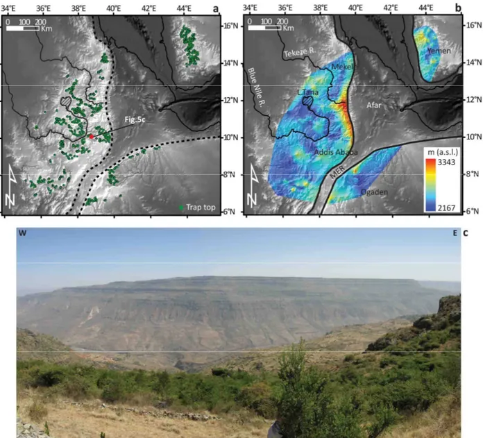
Figure 3 - a) DEM of the study area and
locations of traces of the four swath profiles; b-c-d-e) swath profiles showing the trends of the maximum, minimum and mean topography of the Ethiopian Plateau. In each profile local relief has been computed by subtracting the minimum from the maximum elevation.
- 29 -
calculating the average difference in elevation between the present topography (DEM) and the reconstructed Trap top surface ("geophysical relief" - Small and Anderson, 1998). It allows to investigate the erosion pattern and its possible relation with trap thickness.
To investigate the relationship between the Trap geometry and the underlying basement we also elaborated two geologic sections
1.5 Results
All the swath profiles show a dome-shaped topography (Fig.3). The dome has a maximum elevation of ~2500 m, corresponding to the Addis Ababa area, and a diameter between 1100 and 1400 km with the maximum elongation axis trending SW-NE. All around the dome the topography dramatically drops ~500 m. The high peaks in the profiles correspond with volcanoes rising from the plateau up to 4500 m (Fig.3). The general dome shape is interrupted by the MER which is located directly east of the apex of the dome. Throughout the dome local relief is mostly constant at ~500 m, even where the principal drainage basins (Blue Nile, Tekeze and Omo basins) are located (Fig.3). This flat pattern indicates a very low spatial variation in fluvial incision in the whole study area. The highest values (up to 900 m) concentrate on the plateau margins where the drainage systems are capturing the inner part which, in turn, appears to be less affected by erosion (the local relief decreases down to 200 m) (Fig.3).
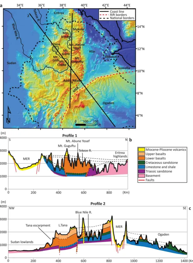
The Trap base surface shows a rough topography ranging from 450 to 2750 m (Fig.4b). The highest sectors are the Mekele and Addis Ababa areas. These two topographic highes are separated by a wide depression oriented NNW-SSE and extending from Desse to Lake Tana (Desse-Tana Depression). Such feature presents an irregular, almost triangular shape: the width ranges from 200 to 400 km, while its depth increases from 600 m to 1000 m to the NW. The presence of this depression under the Trap deposits is also evidenced by geological sections (Figs.4e) and by gravimetric investigation for oil extraction (W. St. John, Unpublished report, 1994). The lineaments analysis shows a strong correlation between the Dessie-Tana Depression and the principal tectonic structures occurring in the Lake Tana area (Fig.4c). In particular the depression trend coincides mostly with the Debre Tabor graben one (Fig.4c). In the western part of the Trap base map (Fig.4b) a 200 km long and 50 km wide depression trending NW-SE is partially coincident with the present lower course of Blue Nile R.
The Trap top surface presents an average altitude of 2500 m (Fig.5b). The lowest elevations are located all around the Ethiopian plateau reaching the minimum (2000 m) in the Mekele area.High
- 30 -
Figure 4 - a) Map of the stratigraphic contacts basement/flood basalts and Mesozoic sediments/flood basalts. The red
point indicates the location of Fig.4d; b) map of the CFB base surface. The dashed black box indicates the location of Fig.4c; c) map of lineaments in the Lake Tana region. The locations of the main graben structures coincide with the wide depression found in Fig.4b; d) panoramic view of the Blue Nile valley. The black lines indicate the stratigraphic contacts between the main lithologies; e) geological section across the Tekeze R. located at the northernmost edge of the depression (profile A-B in Fig.4b). Note that the Triassic Sandstones gently dip toward SW; f) panoramic view of the Triassic Sandstone immediately north-west of Mekele. The strata dip to the SW, as evidenced in Fig.4d.
Angareb ring complex
- 31 -
Figure 5 - a) Location map of the plateau remnants used to reconstruct the flood basalts top surface. The red point
indicates the location of Fig.5c; b) map of the CFB top surface; c) plateau remnant along the Jema R. valley immediately northwest of Addis Ababa.
elevations of the Trap top surface (between 2700 and 2850 m) are concentrated under the volcanoes which preserved the original basalts thickness from erosion. The highest elevations are along the eastern portion of the Ethiopian Plateau. Here the flexural uplift of the rift shoulder deformed the basalts starting from the Late Miocene (Weissel et al., 1995; Wolfeden et al., 2004; Bonini et al., 2005) (see chapter 3 of this thesis). The same high values are registered in the Yemen region. According to Dadarich et al. (2003) this is due to the combined effect of the flexural uplift of Red Sea shoulders and of the dynamically supported tilting of the Arabian plate eastward. The Trap thickness map shows an asymmetrical distribution with respect to the Afar depression and to the rift valley (Fig.6a). Most of the entire volume forms the Ethiopian plateau and concentrates around Lake Tana. Thick deposits (1500-1800 m) fill the Desse-Tana Depression and are located in correspondence of the lower Blue Nile R. valley.
- 32 -
The erosion map (Fig.6b) shows that the highest amount of erosion concentrates along the Tana escarpment (1500-2000 m) and the main fluvial trunks with particularly high values in the lower and medium Blue Nile basin (1250-1750 m). The lowest values (0-250 m) concentrate in the inner portion of the plateau.
In the geological maps of northwestern Ethiopia (scales 1:250.000 - [Hailu, 1975; Kazmin, 1976; Garland, 1980; Tsige and Hailu, 2007; Chumburo, 2009; Zenebe and Mariam, 2011]) Trap are separated into two main units: lower and upper basalts. Geological sections (Fig.7) cutting across the dome show that the lower basalts filled the Desse-Tana Depression (average thickness of 1000 m) while the upper basalts simply flowed onto the lower ones reaching the originally more elevated zones of northern Ethiopia and Eritrea (basalt thickness between 250 and 500 m; Fig.7b).
Figure 6 - a) Flood basalts
thickness map obtained by subtracting the basalt's base surface from the basalts top one (see text for further explanation);
b) erosion map resulted from the
subtraction of basalts top surface from the present topography (ETOPO1 DEM database). For further explanation see the text.
- 33 -
The lower basalts constitute the bulk of the Ethiopian Plateau while the upper basalts seem to be related to more local volcanic episodes. The geological sections show also a dome-shaped deformation of the basement rocks (Fig.7c).
Figure 7 - a) DEM of the Ethiopian Plateau and surrounding areas (ETOPO1 DEM database). The straight solid black
lines indicate the location of the two geologic sections (Figs.7b-c); b-c) geologic sections of the Ethiopian Plateau and surrounding areas compiled using the geological maps of Ethiopia (scales 1:2.000.000 [Kazmin, 1972; Tefera et al., 1996] and 1:250.000 [Hailu, 1975; Kazmin, 1976; Garland, 1980; Tsige and Hailu, 2007; Chumburo, 2009; Zenebe and Mariam, 2011]) and Sudan (scale 1:2.000.000 [G.M.R.D., 1981]).