URBAN VISUALITY,
MOBILITY,
INFORMATION
AND TECHNOLOGY
OF IMAGES
This project has received funding from the European Union’s Horizon 2020 research and innovation programme under the Marie Sklodowska-Curie grant agreement No 734602.
URBAN VISUALITY,
MOBILITY,
INFORMATION
AND TECHNOLOGY
OF IMAGES
Title: Urban Visuality, Mobility, Information and Technology of Images
ISBN: 978-83-955375-4-7 DOI 10.5281/zenodo.4038130
Edited by: Aleksandra Łukaszewicz Alcaraz, Flavia Stara
Scientific reviewer: dr hab. prof. UR Wojciech Walat Published by: Wydawnictwo Akademii Sztuki w Szczecinie
Language correction: Marlene de Wilde Visual identification: Anna Witkowska Graphics and editing: Natalia Janus-Malewska
This is and open access publication. The work is distributed under the terms of a Creative Commons Attribution NonCommercial-NoDerivatives 4.0 International Licence (CC-BY-NC-ND). Details of this licence are available at : https://creativecommons.org/ licenses/by-nc-nd/4.0/ Szczecin 2020 WYDAWNICTWO AKADEMII SZTUKI W SZCZECINIE
Table of Contents
Aleksandra Lukaszewicz Alcaraz
Urban visuality in intercultural perspective Part I
Perceive, inhabit, understand, and transgress urban spaces. Visual readings between Kenya and Italy
Flavia Stara
Images of cities and invisible landscapes Stefano Polenta
Image and place. Which relationships? Raffaele Tumino
Force of images and critical distance Giuseppe Capriotti
In a savannah of images. Artistic production and public spaces along the Kenyan Coast
Part II
Intercultural perspectives on visual communication in urban settings in Europe and in Kenya
Rosita Deluigi
Intercultural trespassing: Educational errancy between urban spaces and relational places
Grazyna Czubinska and MA Roman Mazur,
Visual communication in urban spaces of Berlin for the future transportation solutions evolving out of TICASS as academic project supported by the EU
Tomáš Pavlíček
Visual aspects of architectural development of public space on the chosen urban cases
Aurelia Mandziuk-Zajączkowska
ConTEXTile. Fabric, its functions, meanings, ornaments as the universal non-verbal language
Part III
Visuality in education and visual literacy Maria Czerepaniak-Walczak
For whom and what are visual signs in an open urban space. Their functions of inclusivity and exclusivity
Michael Maua
Rethinking information competency in academic libraries in Kenya
Lidia Marek
Monuments in urban public spaces as visual messages – an ethical perspective
Aleš Loziak
The visual (photographic) literacy of an individual in a public environment
Part IV
Visual urban spaces in social-community life Łukasz Skąpski
Public space in Nairobi. Diagnosis Based on visual messages of public space
Lea Horvat
Post-socialist readability of socialist mass housing estates: Examples from ex-Yugoslavia
Stephen Muoki
Imaging AIDS in Kenya: A historical analysis of public and visual messages on HIV and AIDS epidemic between 2011-2018
9
25
43
59
71
95
117
137
159
171
187
199
217
233
265
283
Urban Visuality
in Intercultural
Perspective
Aleksandra Lukaszewicz Alcaraz
Academy of Art in Szczecin, Poland
Abstract
The essential migration from rural to urban areas has had various consequences for human lives, creating a specific kind of iconic sphere or environment in which one of the basic means of communication is visual communication. The ubiquity of images and their multitude in commerce, politics, mobility, safety, education, and entertainment require the development of literary skills within visual communication. Interpreting perceived images, understanding them, acquiring the ability to approach them critically, redefine them and construct one’s own visual communiques in an intercultural perspective are contemporary needs.
The need for intercultural visual literacy should be fulfilled by educational programs at all levels, starting from kindergarten and continuing to the university level. These programs should be developed, and the main goal of the TICASS project is to elaborate a set of recommendations for the task of considering visuality in the intercultural perspective, which allows one to search for similarities and differences in perception and interpretation of images across different cultures.
Keywords
urbanization visuality interculturalism dialogue visual education visual literacyUrbanization Processes Worldwide
The essential migration from rural to urban areas has had various consequences for human lives, creating a specific kind of iconic sphere or environment in which one of the basic means of communication is visual communication. Visual communication strongly affects practical urban life, although of course not the world’s population lives in cities or is solely visuality urban. Visuality is the sphere in which we are immersed in various circumstances and conditions because it is one of the basic modes of reality available to us and which we experience sensually. However, urban visuality is specific, different from the rural experience. It is much more condensed, brighter, more aggressive, and more hectic, although there are essential variations between its modulations in various countries and continents (as, for example, between Nairobi and Oslo or Szczecin). This urban visuality is the everyday environment of a large share of the population living in urban areas nowadays.
Urbanization processes are occurring worldwide though there are important differences in urban development between various continents. The largest segment of population living in urban areas is in North America with 81.6%, followed by Latin America and the Caribbean with 79.8%, according to statistics presented by Eurostat in 2016. The share in Europe is also high, with 73% of Europe’s population living in urban areas.
Il. 1 Share of urban and rural population, 1950-2050. Eurostat (2016). Urban Europe. Statistics on Cities, Towns, and Suburbs. European Union 2016, p. 8.
Currently, 3.4 billion out of 6.9 billion people live in the countryside, and world urbanization prospects foresee that approximately two-thirds of the world’s population will be living in an urban area by 2025 (Statista 2019). According to Eurostat:
This rapid pace of change is projected to be driven primarily by changes in Africa and Asia, as the focus of global urbanisation patterns continues to shift towards developing and emerging economies. The pace of change in Europe will likely be slower, with the share of the population living in urban areas projected to rise to just over 80% by 2050 (Eurostat, 2016, p. 9).
In analysing processes of urbanization on different continents, it becomes obvious that there is not only more than one pace but also multiple patterns of urbanization. Urban structure and spatial distribution in Europe, Asia, and America (as well as Africa – not mentioned in the study) differ considerably.
Europe is generally characterised by a high number of relatively small cities and towns that are distributed in a poly-centric fashion; this reflects, to some degree, its historical past which has led to a fragmented pattern of around 50 countries being spread over the continent. By contrast, in some parts of Asia and North America, a relatively high proportion of the urban population is concentrated in a small number of very large cities (Eurostat, 2016, pp. 9-10).
The situation of Africa is also special; despite the continuous growth of urbanization in Africa since the 1950s, when over 80% of the population lived in rural areas, most of the populace is still there: in 2015, 59.6% of Africa’s population was living in rural areas. Kenya’s situation is in accord with the general African one; according to World Bank data from 2018, in 1960, 93% of Kenyans lived in rural areas while in 2017 it was 73% (The World Bank, 2018). That means that in a little over 50 years, 20% of the population had moved from rural to urban areas (which, however, still does not reach the rate in American or Asian megacities).
Internal migrations in Africa bring changes in traditions, practices, customs, forms of mobility, and languages, in part because of the influences by various tribes on each other. Of course, these influences are at play in Kenya too. This is not my focus, but I shall note that they are both positive and negative, depending on which level of social life we examine. It is not only culture that is influenced by migrations but also economics and the very fabric of society. The general value of this statement allows one to analyse the migrations – for example – of wealthy and educated persons from the centre of Kenya to the Indian Ocean coast, or of workers from Central and Eastern Europe to the United Kingdom and Scandinavian countries.
Migration in Africa is mostly from villages to big cities. In Kenya the population is heavily concentrated in the west, along the shores of Lake Victoria and in Kisumu (1,118,000); other areas of high density include the capital of Nairobi (3,375,000) and in the southeast along the Indian Ocean coast and in Mombasa (1,200,000).
Il. 2 Population density in Kenya in Jayne, T. & Muyanga, M. (2012)
Migrants are mostly young people, as the Kenyan population is generally young, with a median age of 20 years: more than 40% of Kenyans are under the age of 15 because of sustained high fertility rates, early marriage and childbearing, and an unmet need for family planning (CIA, The World Factbook).
Visual Communication
and Visual Order in Cities
Cities are different environments from rural ones. The higher prevalence of technology, as well as economic, political, and cultural institutions, transform ways of living, everyday routines, traditions, opinions and worldviews, and modes of communication. The necessity of combining various social, political, cultural, and ethnic groups in one area and of implementing order (which in most cases is neoliberal nowadays) requires effective and quick communication, both mass and individual. For this purpose, visual communication serves very well.
By “visual communication in urban spaces” I predominantly mean indicative signs, traffic signs, information boards, advertisements (commercial or social), legal and illegal stickers, and paintings on buildings (like murals or graffiti); as well as, to some extent, online visual communication with a smartphone as it very often manages human mobility in cities by being a medium through which to arrange meetings with other people and through various applications for public transport (applications with bus/tram/metro/ train timetables, or connections to other buses or transport lines, Google Maps, and a GPS system). Starting from the smartphone in our hands, through traffic signs, advertisements, digital screens, and posters, we find ourselves immersed in the iconosphere around us, the sphere of images. Of course, the level of technological development of different cities varies so the iconosphere may be more or less dense, but it is inarguably an integral part of the contemporary urban environment.
Younger generations are generally more well acquainted with visual communication because its growth has been accompanied by neoliberalism and technological development; the latter can be traced back to the beginning of 20th century, marked by Henry Ford’s first mechanized Detroit factory in 1903, and the invention by Oskar Barnak in 1913 of the 35 mm camera (Leica), which led the way to massive photographic production and reproduction. Contemporary technological development has accelerated the filling of urban spaces in many countries with screens and digital imagery, eye-catching, hectic, and consumeristic: as in Times Square in New York and Piccadilly Circus in London.
Some smaller, usually more sustainable, cities try to limit and control visual communication so that it does not predominate the basic human need for clean surroundings, visual order, and light. Such positive practices govern the control of commercial signs in public spaces and malls, not allowing large billboards to cover important parts of the city or the landscape: take for instance Scandinavia, which is visually well-organized in a modest but developed way (interestingly, QR codes are popular in cities like Oslo, connecting one with historical information about the place, its buildings and statues, or with transport information).
Negative practices result from neglecting the human need for cleanliness, order, and light – often preferring quick financial profit. Completely covering bus windows with commercial stickers or graffiti prevents natural light from entering or prevents the opening of them (as still happens sometimes in Poland). Following strong social critique of such practices in the media in 2010 and 2011, large ads slowly started to disappear due to the changing contracts between municipal communication institutes and advertisers in each city. Another bad practice is covering a building façade with advertising during the process of renovation when it is still occupied, where residents are in this situation cut off from light by the advertisement: this was also a case in Poland, banned by regulations implemented by the Ministry of Infrastructure in 2009.
Covering blocks of flats with huge advertisements goes against the personal right to privacy, the inviolability of the flat and the right to rest. The issue was discussed publicly after one Warsaw citizen claimed that her rights were being violated before the court. An advertisement was hung 20–30 cm from the building, shutting out the view as well as sunlight. At night, bright lights shone on the ad, also illuminating the inside of the flat and impeding the occupants’ sleep. This claim, and a following case, brought about changes to the regional regulations concerning technical conditions regarding buildings and their locations, demanding that “spaces dedicated for the stay of people must have guaranteed daylight, customized according its purpose, shape, and volume” (PAP, 2009).
It is important to think about visual order in cities and the people’s quality of life; their neglect shows the social divisions imprinted in the urban tissue. People who have less access to clean air, daylight, comfortable living spaces, and pleasant sounds and smells are separate from those who have access to them every day. The spatial division of sensory order and pleasant atmospheres in cities expose social and class divisions. This point was inspirationally exposed by Arnold Berleant when he wrote about negative aesthetics (Berleant, 2010) in the cities of late capitalism, filled with oppressive smells, sounds, images, and spaces. Analysis of these sensorily experienced factors of urban social life brings Berleant’s claim for social justice from the point of view of everyday sensory experiences and the common environment. Sensitivity is common to all humans, and it requires freedom from oppression that results in abuse, social inequalities, and poverty in many contemporary cities – especially mega-cities.
The driving processes of urbanization and urban management in various countries and cultures should be consequent to learning from others’ experiences and mistakes in order not to repeat them all, but there are shortcuts towards sustainable urbanization, friendly for individuals and groups, creating the possibility for free and peaceful cohabitation. This is the direction shown by strategic international and European documents on urbanization processes, prospects, and management.1 The United Nations
1 For example: The United Nations “supports […] planning and building a better urban future through
and the European Union realize the importance of creating and maintaining a friendly environment in cities, places with very dense populations in many countries around the globe, and propose that urbanization should be managed with concern for the quality of life in cities. Friendly urban environments are inclusive for various social groups and should be understandable in terms of structure and communication; offering the possibility to live well, a respite from aggressive advertisements, disorder, and dirt. Urban visuality is an important part of the urban fabric, which should be concerned in the processes of its – hopefully sustainable – development.
Kenyan Urban Visuality
Visual order in public spaces in Kenya is considerably different from European countries; some may call it disorder but I would rather claim that it is in a way organic.2 It proliferates with little control, responding to the individual needs of persons, or institutions and companies. On different levels of social life, it varies: 1) on the community level, it is based on body language, facial expressions, and textiles (gestures, faces, leso3); 2) on the local commercial level, it is based on hand-painted iconic representations; for instance, painted fruits indicating the market, a menu on the restaurant wall, or a car battery painted on the gate of a car workshop; 3) on an international commercial level, it depends on large billboards with photographs.
Newcomers to a Kenyan town or city must learn the visual strategies of the place in order to understand and produce meaningful visual expressions: in everyday gestures and in work with children, youths, and adults as an educator. This is a need for visual literacy, the ability to understand and produce meaningful and creative visual communications. This ability, like language, is conditioned culturally – as we deal with 6500 spoken languages in the world today, we must consider many visual languages in connection with perspectives on the world and cultural backgrounds, expressed in everyday activities and their forms.
support for economic growth and social development, while targeting reductions in poverty and social inequalities,” especially within UN-Habitat programme (Eurostat, 2016, p. 17.) For more than 20 years, European Union urban policy has been directed towards sustainable development, aiming at bettering human life conditions and making cities pleasant places to live. “Urban areas have the potential to play important role in the EU’s renewed sustainable development strategy, which underlines how to deliv-er sustainable development commitments, while reaffirming the need for global solidarity, in orddeliv-er to achieve smarter, more sustainable and socially inclusive urban development […] recognized as a key element in the Pact of Amsterdam” (Eurostat, 2016, p. 20.)
2 The fact that traffic and transport in towns and cities lack municipal visual ordering is charming to some extent, but it is also the cause of a high death rate in Kenya – which in 2017 was 2750 persons dead as of 21 November 2018: 2509 (NTSA.)
3 Kanga or leso is a pure cotton cloth that originated on the East African coast in the mid-nineteenth century.
Historical and Cultural Roots of European Urban Visuality
The European iconosphere is structured and deeply rooted in the culture, the reason being that its contemporary technological development is controlled and organized in a rational way, while the African iconosphere is more spontaneous and organic. This has some historical basis – Europe, since ancient Greece, has favoured the sense of vision over other senses, connecting sight with truth, knowledge, and reason, and discarding the other senses as connected to primal biological nature, which has been tamed by culture. By the time of Plato, sight was considered the foundation of philosophy (Plato’s highest state of knowledge was the contemplation of ideas [Plato, 1959]). For Aristotle, empirical, rather than idealistic, vision was taken as the clearest of the senses (Aristotle, 1961). The importance of sight and its connection with knowledge was further developed by Galileo, Locke, and Descartes.This importance is visible in the artistic and functional modes of visual organization in place throughout history. Ancient Greeks valued symmetry and the golden mean, reflected in forms of human representations (head is 1:8 to the body), in the structures and elements of buildings like temples and columns (of Doric, Ionic, or Corinthian order, proportionately).4 The harmony of the whole was built on the individual formation of each part, along with the particular balanced composition of these elements. Contemporary visual structures may be deliberately unbalanced, especially in the field of contemporary art. However, in public spaces for citizens and visitors, visual communication in Europe is usually measured.
Visual Education, Urban Aesthetics,
and Interculturalism
In order to make visual communication effective and friendly, it should not “shout too loud” or infringe the basic human need for light, a clean environment, and not being disturbed. In many European countries, regulations are in place regarding advertisements and political propaganda in public spaces and elsewhere, lest they proliferate. These practices are based on European cultural canon, containing rules managing the aesthetic – predominantly visual – environment. However, neither laws nor canon are always obeyed, resulting in ineffective, abusive, unhealthy, or unsafe environments: this demands, as a remedy, visual education and visual literacy.
4 Doric (1:4-1:8), Ionic (1:8-1:9), Corinthian (1:10.)
In this field I would like to mention one educational project “Visionpedia, that is how to look in order to see,” initiated by the Foundation for Development of Visual Culture BOOKAMORE. Within this project, artists, illustrators, designers, and architects (among them: Chris Niedenthal, Allan Starski, Leszek Szurkowski, Adam Pękalski, Jakub Szczęsny, and Victor Gad) are creating a physical book and online encyclopaedia of rules governing visuality; they believe that the quality of public and functional spaces and the appearance of objects and aesthetics of the surroundings all influence human lives and minds, our decision-making, and how we organize time. Within the project illustration boards are created, each referring to an issue of colour, composition, perspective, or history of art and design.
One drawback of this project is the lack of contextualization to European culture. The project might benefit from opening up to intercultural perspectives by including recognition of other visual languages (for example, symmetry in Japanese aesthetics is boring and oppositional to beauty, which should give a sense of permanence and the possibility of different continuations, accounting for different structure in Japanese cities). Intercultural perspective is obligatory in our contemporary world when dealing with urbanization, urban management, visual management, sustainable development, and visual order.
Il. 3 Preliminary screen for Widzipedia (Visualpedia) Warsaw Metro Project. Leszek Szurkowski (Creative Director).
Consciousness of the essential cultural conditioning of one’s worldviews, knowledge, ideas, concepts, vision, images, relationships, practices, and so forth, has been constructed from a philosophical background deprived of privileged transcendental standing: one must accept relativism in cognition and in ethics. This drives one toward multiculturalism (recognizing cultural variety) and interculturalism (targeting dialogue between cultures).
Interculturalism as an approach needs to be developed theoretically and practised in everyday dialogue. The need for dialogue is ever more pressing, in part due to the waves of migration from Africa and the Middle East into Europe. Apart from dialogue on social and political levels, it is useful to conduct research into the different forms of visuality and symbolism present in different cultures in order to be able to form friendly and effective methods of visual communication in cities for recipients from various cultures. This research may be useful in the process of designing visual communication systems in public places, in which should be considered such variables as cultural background and level of physical and/or mental ability, as expounded by Radoslaw Nagay (2018, pp. 186-209).
The ubiquity of images and their multitude in commerce, politics, mobility, safety, education, and entertainment around the globe require the development of literary skills within visual communication, which are oriented interculturally. Intercultural readings of European, African, and Asian urban spaces may bring us closer to a common understanding, which should not mean imposing one order on another but rather mutually opening up to and learning from each other, keeping in mind that there are also some evolutionary preferences and modes in perception (Luty, 2011).
Interpreting perceived images, understanding them, having the ability to approach them critically, redefine them, and construct one’s own visual communiques in intercultural perspective – this intercultural visual literacy should be realized by educational programs at all levels, starting from kindergarten and continuing to the university level. It is important that these programs are developed, and the main goal of the TICASS project is to elaborate a set of recommendations for the task of considering visuality in the intercultural perspective, which allows one to address similarities and differences in perception and the interpretation of images across different cultures.
In this book, there are articles by TICASS researchers investigating images and visual communication in urban public spaces, their cultural roots and contemporary challenges, their historical contingencies, forms, and social as well as educational functions from various perspectives. It is divided into four parts: Part I. Perceive, inhabit, understand, and transgress urban spaces. Visual readings between Kenya and Italy; Part II. Intercultural perspectives on visual communication in urban settings in Europe and in Kenya; Part III. Visuality in education and visual literacy; Part IV. Visual urban spaces in social-community life.
Il. 4 Preliminary screen for Widzipedia (Visualpedia) Warsaw Metro Project. Leszek Szurkowski (Creative Director).
Il. 5 Preliminary screen for Widzipedia (Visualpedia) Warsaw Metro Project. Leszek Szurkowski (Creative Director).
Part I. Perceive, inhabit, understand, and transgress urban spaces. Visual readings between Kenya and Italy contains chapters by Italian scholars considering intercultural forms of experience (Flavia Stara, Images of cities and invisible landscapes), focusing especially on visual experience and asking for ways of creating intercultural understanding (Stefano Polenta, Image and place. Which relationships?), and for critical distance in approaching images and visual communication, which should result in visual literacy critical education (Raffaele Tumino,
Force of images and critical distance). The closing chapter draws our
attention to characteristic image production in artistic and public spaces along the Kenyan Coast (Giuseppe Capriotti, In a savannah of images. Artistic
production and public spaces along the Kenyan Coast).
Part II. Intercultural perspectives on visual communication in urban settings in Europe and in Kenya focuses on various special cases of visual communication in societies in Kenya, Italy, Germany, and the Czech Republic. The opening chapter by Rosita Deluigi introduces a broader understanding of human-environment relations, which results in leaving more or less temporal visual traces by people in various settings (Intercultural
trespassing: Educational errancy between urban spaces and relational places). Other papers analyse precisely the visual communication system
of public transportation in Berlin (Grazyna Czubinska and Roman Mazur, Visual
communication in the urban spaces of Berlin for the future transportation solutions evolving out of TICASS as an academic project supported by the EU); the historicity of a city, as a mental image of its inhabitants, in the case
study of the North Bohemian city Most (Tomas Pavlicek, Visual aspects
of the architectural development of public space on the chosen urban cases);
and the visual communication realized with textiles used in everyday life in Kenya (Aurelia Mandziuk-Zajączkowska, ConTEXTile. Fabric, its functions,
meanings, and ornaments as the universal non-verbal language).
Part. III. Visuality in education and visual literacy contains various works on competences in visual literacy and its institutional, social, political, educational, artistic, and critical functions. The first chapter considers the division between visual messages that are inclusive and exclusive, from the perspective of ideals put forth by Habermas on public space and public debate (Maria Czerepaniak-Walczak, For whom and what are visual signs
in an open urban space. Their functions of inclusivity and exclusivity).
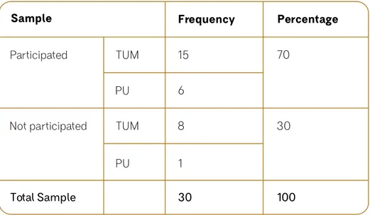
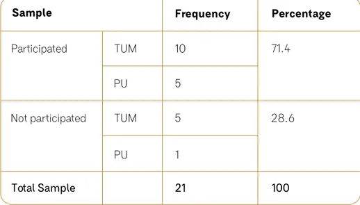
Others are based on analyses of empirical research, as in the case of a descriptive survey of Kenyan librarians in regards to visual literacy in academic libraries at Pwani University and the Technical University of Mombasa (Michael Maua, Rethinking information competency
in academic libraries in Kenya) as well as an analysis of historically
contingent meanings of monuments in public spaces in Szczecin (Lidia Marek, Monuments in urban public spaces as visual messages
– An ethical perspective); and in artistic communicative strategies
used in contemporary art in Czech Republic (Ales Loziak, The visual
(photographic) literacy of an individual in a public environment).
Part IV. Visual urban spaces in socio-community life closes by focusing on social, political, economic, cultural, and religious aspects of specific imagery: on neoliberalist visual imagery in Nairobi proving its anti-humane aspect (Lukasz Skapsku, Public space and economic liberalism.
Diagnosis based on urban visual messages); on post-socialist visual
transformations in the ex-Yugoslavian, present-day Croatian city of New Zagreb (Lea Horvat, Post- socialist readability of socialist mass housing
estates: Examples from ex-Yugoslavia); and on historical transformation
of the public approach to the HIV/AIDS epidemic issue in Africa and its exemplification in visual messages in public spaces in Kenya (Stephen Muoki,
Imaging AIDS in Kenya: A historical analysis of public and visual messages on HIV and AIDS epidemic between 2011-2018).
Bibliography
• Aristotle (1961). Aristotle’s Metaphysics. London: Dent; New York: Dutton.
• Berleant A. (2010). Sensibility and sense: The aesthetic
transformation of the human world. Exeter: Imprint Academic.
• Eurostat (2016). Urban Europe. Statistics on Cities, Towns and
Suburbs. European Union 2016.
• Jayne, T. & Muyanga, M. (2012). Land constraints in Kenya’s densely populated rural areas: Implications for food policy and institutional reform’. Food Security, Vol. 4. DOI: 10.1007/s12571-012-0174-3. • Luty J. (2011). Estetyka ewolucyjna – sztuka jako adaptacja w ujęciu
międzykulturowym. Estetyka i Krytyka, Vol. 21, No. 2.
• Nagay, R. (2018). Visual Communication 3.0: Communicating visually in the 21st century – using modern technologies and understanding various recipients’ needs, in Visuality from Intercultural Perspectives:
Technologies of Imaging in Communication, Art and Social Science,
M. Fleming, A. L. Alcaraz (eds)., Szczecin-London: PUNO Press. • Plato (1959). Plato’s Timaeus. Indianapolis: Bobbs-Merrill.
Online sources:
• CIA (Central Intelligence Agency). The World Factbook: Africa: Kenya. • https://www.cia.gov/library/publications/the-world-factbook/geos/
ke.html [access: 12.02.2019].
• NTSA (National Transport and Safety Authority) Accident Statistics:
Fatal Report as 27th January 2018 & Daily Report as at 27th January 2018.
• http://www.ntsa.go.ke/index.php?option=com_
content&view=article&id=213&Itemid=706 [access: 12.02.2019]. • PAP (Polish Media Agency) (2009). Large-format ads will disappear
from buildings’, Wprost, 06.03.2009.
• https://www.wprost.pl/kraj/155336/Reklamy-wielkoformatowe-znikna-z-budynkow.html [access: 12.02.2019].
• Statista (2019). The Statistics Portal. Statistic and Studies from more
than 22,500 Sources
• https://www.statista.com/statistics/267838/global-urban-and- rural-population/)
• The World Bank (2018). Rural Population (% of total population). World Bank Staff estimates based on the United Nations Population Division’s World Urbanization Prospects: 2018 Revision.
• https://data.worldbank.org/indicator/SP.RUR.TOTL.ZS [access: 12.02.2019].
List of illustrations:
• Il. 1 Share of urban and rural population, 1950-2050. Eurostat (2016).
Urban Europe. Statistics on Cities, Towns and Suburbs. European
Union 2016, p. 8.
• Il. 2 Population density in Kenya in: Jayne, T. & Muyanga, M. (2012). Land constraints in Kenya’s densely populated rural areas: Implications for food policy and institutional reform. Food Security, Vol. 4. DOI: 10.1007/s12571-012-0174-3.
• Il. 3 Preliminary screen for Widzipedia (Visualpedia) Warsaw Metro Project
• Leszek Szurkowski (Creative Director).
• Iwona Kokoszka Founder Bookamore Foundation for the Development of Visual Culture.
• Il. 4 Preliminary screen for Widzipedia (Visualpedia) Warsaw Metro Project
• Leszek Szurkowski (Creative Director).
• Iwona Kokoszka (Founder), Bookamore Foundation for the Development of Visual Culture.
• Il. 5 Preliminary screen for Widzipedia (Visualpedia) Warsaw Metro Project
• Leszek Szurkowski (Creative Director).
• Iwona Kokoszka (Founder), Bookamore Foundation for the Development of Visual Culture.
Images of Cities
and Invisible Landscapes
Flavia Stara
University of Macerata, Italy [email protected]
Abstract
This article analyses the perception and understanding of the visual environment in reference to research carried out in the coastal Kenyan territory. The focus is on the visible and invisible landscapes revealed to a transient inhabitant. Visual space becomes a living space that is both an area of passage and an internalized reality: a place in which personal visual spaces are connected and reckoned from a distance that enhances the comprehension of the dimensions of otherness. Referring to Foucault’s concept of heterotopia, this is the space that one can enter and exit based on subjective decisions, a space-time filled by dialogue. This article will examine how some visual features in cityscapes relate to the definition of cultural identity and to the structuring of a mental urban setting. It will consider the quality of imageability (Kevin Lynch), which attributes to a physical space a high probability of evoking feelings in any given observer. The shapes and colours of a lived environment relate to pre-structured representations of meaning. Hence the paper explores how through the category of legibility, or visibility, it is possible to recognize three spaces: physical, mental, and social. Each type of space takes on different developments of meaning expressed through the dynamic association of elements perceived, conceived, and lived.
Keywords
landscapes heterotopias perception understanding meaningsUrban Landscapes as Heterotopias
The comprehension of visual messages and meanings internalized
by coming across different habitats carries with it a critical awareness of what occupies the space and how. This process of recognition takes place through the appreciation of the layers of meaning revealing the environmental settings, socio-cultural fabrics, sensory phenomena, and production of imagination, such as projects and projections, symbols, and utopias.
Urban landscapes are possibly the largest and most social of human constructs and are efficient symbols for creating a kind of mental topography. They are highly visual; they are large and concrete, so that we may move within them; they seem to comprehend the whole of human experience in an encyclopaedic fashion and they enter into a dialectic relation with humanity: people shape cities, and cities shape people. A transient inhabitant observes and dwells in the physical and cultural space in which they are placed by combining possible phases of representation and interpretation of natural and built-up areas with interior invisible landscapes and untraced urban paths. The in-transit inhabitant ascribes to local morphology an unsuspected centrality, exploring all the features in a non-habitual fashion. The person in transit experiences a given urban space, applying a system of reference codes which are simultaneously known and under modification. From this encounter emerges a hyper textual city that offers properties and resources based on a temporary stability. The relationship with time becomes relevant to understanding the evolution of the representations of spaces. Being in a transient and uprooted living status induces internal territorial narratives. The visualization of individual mental maps gives shape to invisible cities, outlining a new design of the hosting space.
This experience can be meaningfully construed with reference to some conceptual schemes elaborated by scholars who have dealt with the phenomenology of the relationship between individuals and the visual-physical space they occupy. Considering the concept of heterotopy studied by Michel Foucault, the absolutely other space allows us to understand the mechanisms through which we project ourselves elsewhere without a precise place to locate ourselves. Foucault introduces the term heterotopia to define a fragment of fluctuating space that is closed on itself but at the same time in connection with the world. The perception of heterotopy is an experience of estrangement while remaining in contact with reality. It may also be understood as a space that one can enter or exit based on subjective decisions and personal projects. Unlike utopia, the non-ideal and unrealized place, heterotopy is an “other” place that produces a state of interference and restlessness, providing a sort of mirror in which the identity reflects itself and tries to comprise itself from the outside (Foucault, 1998).
In light of these considerations, it is possible to connote as heterotopy the space-time experienced in coastal Kenya by the authors of the present book: a space-time lived in a state of separation and belonging;
a condition in which inner personal visual images are evoked and reckoned to build new frames of understanding. This experience of dialogue generated by internal and external visual and acoustic stimuli in continuous succession includes a subtle alchemy of connections among space settlements, urban morphology, cultural models, and expressions of economic and political power. Individuals are actors in the space and interact with it according to their frequencies. The notion of heterotopy reveals its heuristic value through the reciprocal reflection of cultures.
The present text is the result of a fieldwork research project in the Kenyan county of Kilifi, which offered to the author the opportunity to intercommunicate in a specific natural and cultural visual environment. The condition of being dissociated from one’s original place and placed elsewhere solicits a fertile adventure of imagination, since as a traveller one feels that something important is happening, that they are taking part in an experience in which they are at once witness and creator.
In accessing the real and imagined Kenyan coastal space, the first element encountered is light: strong light, intense sun. Then there is the urban setting without refined architecture, simple constructions plastered together, with small and cramped mud houses. Thence appears endless constellations of vegetation, an exuberant green of palms, baobabs, and forests that signals a biology which produces and flourishes tirelessly. Then one meets the traffic and the noise of the streets: people spend the day outdoors, moving freely and naturally in the rhythm imposed by climate and tradition. The natural and anthropic landscapes form an inseparable and harmonious whole, identifying the one in the other. The traveller, who at times seems a spurious, incongruous, dissonant element in this environment – often in the grip of fear of everything that moves, from mosquitoes to snakes – eventually plunges into the light and traces their paths of recognition (Kapuściński, 1998).
Il. 1. Małgorzata Szymankiewicz, Visual Document Analysis Card according
to H.D. Lasswell 2/4-18. TICASS research materials.
Il. 2 Flavia Stara, Paths and Encounters.
Il. 3 Adéla Machová, Visual Document Analysis Card according
to H.D. Lasswell 2/2-8. TICASS research materials.
Il. 4 Monika Zawadzki, Visual Document Analysis Card according
Inside the Landscape
In The Image of the City (1960), one of the most representative works in urban design studies, Kevin Lynch describes a new approach on how to read the visual forms of cities. The image of urban spaces can be explained as “a picture especially in the mind,” a sentimental combination between the objective city image and subjective human thoughts. A two-way process, between the observer and the observed, influences the productions of environmental images. The observer, with great adaptability and in the light of their own purposes, selects, organizes, and endows with meaning what they see. The image of cities is a dynamic and ever-changing object; it may differ not only in scale but also in viewpoint, time, and season. To understand the role of environmental images in our lives, we must keep in mind their strengths and weaknesses as we are able to select, remove, and increase various elements to organize our representations of the city. Therefore, what we can pursue is an open and constantly evolving figure rather than a fixed description of an urban space. The term visible, which Lynch calls legible, is a visual quality connected to temporal and social factors within a network of space, power, and knowledge. Environmental images can be analysed in three components: identity, structure, and meaning. The forms and colours of a lived environment are connected to representations of pre-structured meaning. Identity is the recognition of an object that implies its distinction from other things. Secondly, the image must include a positional relationship between the observer and the other objects. Finally, this object must have a meaning for the observer, be it practical or emotional. The first and second components are the most readable/visible of the physical elements in urban spaces while the third is linked to the symbolic heritage of cultures.
According to Lynch, the criterion of imageability is built around five feature types that give a qualitative measure to navigation around a place:
Paths: channels along which the observer customarily, occasionally, or potentially moves. For many people, these are the predominant elements in their representations.
Nodes: junctions, a crossing or convergence of paths, may be simply concentrations, which gain their importance from being the condensation of some use or physical character, like a street-corner hangout or an enclosed square.
Landmarks: point-references external to the observer. They are usually rather simply defined physical objects: a building, a sign, a store, or a mountain. Their use involves the singling out of one element from a host of possibilities. Some landmarks are distant ones; other landmarks are visible only in restricted localities and from certain approaches.
Districts: relatively large city areas with common features which observers can mentally explore. The physical characteristics that determine districts are thematic continuities, which may consist of an endless variety of components: texture, space, form, detail, symbol, and so on.
Edges: boundaries which separate two districts with visually predominant and continuous forms. While continuity and visibility are crucial, strong edges are not necessarily impenetrable. Many edges can be defined as unifying seams rather than isolating barriers; some of them are often paths like highways and rivers, which become effective orientation elements as well (Lynch, 2018, pp. 23-33).
Il. 5 Rosita Deluigi, Visual Document Analysis Card according to H.D. Lasswell
Il. 6 Rosita Deluigi, Giuseppe Capriotti, Visual Document Analysis Card according
to H.D. Lasswell 2/1-18. TICASS research materials.
Il. 7 Aleš Loziak, Visual Document Analysis Card according to H D. Lasswell 2/2-6.
TICASS research materials.
Henri Lefebvre, in his work The Production of Space (1974), observes that space is fundamentally bound up with social reality, so space does not exist in itself, it is produced (Lefebvre, 1974). Edward Soja also explores this concept in his theory of trialectics of space, where spatiality is explained through the investigation of three different levels of identification: the first space (perceived space), the second space (conceived space), and the third space (lived space) (Soja, 1996). The interrelatedness of these three orders of space creates the meaning of a place, which is studied through the quality of human activities, particular stories, and people’s perceptions/conceptions of the environment where they are dwelling. Each order of space has a different focus in the attribution of meaning. The perceived space is what Lefebvre calls space practice. It is a human physical space, or space that can be understood through the senses of seeing, hearing, smelling, tasting, and touching (Lefebvre, 1974). Perceived space has various names, such as physical space, natural space, and space practice. This type of space is a real space that relates to everyday life: routes, places of work or business, schools, etc. In contrast to this physical space, the second space is conceived space, which is a conceptualized space, commonly known as mental space, metaphorical space. It also includes the spaces that are acknowledged by people with specific competence such as architects, city-planners, artists, and geographers (Soja, 1996).
Il. 8 Flavia Stara, Districts ( Kilifi, November 18th, 2018, 2.32 pm).
Il. 9 Flavia Stara, Landmark (Mombasa, November 4th, 2018, 10.36 am)
The third space is the lived space, which connects perceived space and conceived space. In the lived space there is inscribed the tangible and intangible heritages of a given socio-cultural context. Thus, in this kind of space a subjective interaction is created between the real space and the imagined space. It is important that these spaces are understood together and not in a rigid categorization since they are interconnected, inseparable, and interdependent (Soja, 1996). In the understanding of visual messages and their meanings, internalized when one comes across different habitats, it is necessary to have a critical awareness of the phenomenology of the lived-in space, with reference to the layers of historical and cultural past expressed by environmental settings.
Visible and Invisible within Landscapes
There is a short temporal separation between action and reflection; that is, a small gap between action and the insights derived from being spectators of that action. One encounters a landscape and becomes the actor and spectator of different actions. We allow the visual impressions to permeate us, or we try to understand through a semiological approach what the landscape can reveal about the people identifying with it. Therefore, it is essential to explore different symbolic languages in order to play out a dialogue with a landscape.
The ways in which urban imprinting is transmitted are the most diverse and unexpected, and have to do with the imagination, with educational background, and with the stimuli gathered through the five senses. To belong to a place is not a personal condition but a shared feeling, the result of the conscious construction of human ties with a cultural heritage.
Any urban landscape can be experienced as the place where everything is possible, a place where the individual frees the imagination towards visualizations of desires and memories, translating them into various and possible reconfigurations of the space itself. Therefore, it becomes a place for creative and acted experimentation. Crossing or stopping in a specific geo-cultural space is always intertwined with the expectations of the individual. Roads, buildings, and natural elements are charged with a precise meaning for the temporary inhabitants. Each individual projects into a momentary habitat their own needs, and in so doing conceives an imaginary city that overlaps with the real one. So, the lived-in space becomes familiar: the sense of belonging is generated through the reciprocity within an implicit and explicit urban life. Any urban space is only apparently exterior to the dweller: its structure is interior to the inhabitant, both as a personal assimilation of shapes, colours, and volumes as well as a personal reconstruction of the visual images. Reality is decontextualized and re-contextualized within a new framework of individual mental categories or sensorial alphabets. The dialectical dynamic of visible/invisible is related to one’s own symbolic heritage, projections, and contingencies. Thus, landscape is a palimpsest of visual layers that express the practical uses of the physical environment and convey the paradigms of the cultural background. In recent decades, new technological developments have opened new ways of depicting, accessing, and theorizing space. Especially with the rise of digital media and the omnipresence of screens, meaning can be created, extended, altered, elaborated, and finally obliterated by the merest touch of a button (Schmid, 2008). The metaphor of landscape as text and spectacle has a well-established position: through the most diverse places and in a juxtaposition of distant cultural representations, beliefs, and rituals, various historical scenarios alternate in their tangible expressions. Volumes and architectures expand in a myriad of visions in search of languages for a deeper understanding of the existent, looking for possible interpretations, towards an orientation for future projects.
The suggestiveness of Kilifi County, along breath-taking ocean views and congested market roads, calls for an encounter that overcomes the expressions of globalization, the visual techniques of reproduction or a polished persistence of colonialism. Intense emotions affect memory and creativity in the production of different narratives. The historical outlines – impressed dramatically or peacefully – both in the urban planning and in nature, express tensions and evolutions that reveal unexpected tangles of fortunate and unhappy situations in the incessant human dwelling. Ideology, politics, and culture merge in urban life into a complex, vital design of old and new representations of innovation and transition. The visual experience enables elaborating a theory of the gaze that sees, describes, feels, and criticizes the core of images in the continuity of their movement: thoughts oriented toward future space configurations.
European knowledge of African heritage is mostly based on the experiences and codes of Western geographers, historians, and anthropologists. The same did not occur to Kenyans, who – under the economic and cultural dominion of Europeans –are only in recent times approaching their cultural heritage according to their own perspectives. Yet the interpretations given by indigenous peoples, who have not had exposure to European paradigms, of their territories diverge from the European views of appreciation. Still, the look of the foreigner may transform and rediscover landscapes wrapped in the mist of the obvious. The foreign gaze as perceived by the inhabitants leads them to behave like actors in a way, original enough to arouse the maximum of curiosity and admiration. The landscape is the background, the theatre in which everyone plays a role, becoming both an actor and a spectator (Turri, 1998). Since our environment is created for the sake of abstract ideas and the functioning of society with dedicated places for what is considered necessary, we ultimately need to realize that we become a product of that space. We become what we are, as social beings, through our body’s reaction to the environment (hearing, tasting, touching, being emotional, or rational), which extends far beyond the mere perception of what the environment is. The visual impact connects internal and external spaces, personal languages with universal symbols, history and spirituality with the socio-economic context, allowing a constant mediation between dimensions and parallel universes. What landscapes reveal also contains traces of what is not seen: that is, the production of mindsets and social structures (Turri, 1998).
Kilifi County features a great variety of forms, reflecting both the complex history of the populations inhabiting the Kenyan coast and their adaptation to the different environmental conditions, as well as the creativity and originality of each tradition. For example, the influence of religious beliefs in the design of architecture, or the practice of customs that determine lifestyles and means of production, or the diversity of customary laws related to family ownership and territorial fragmentation systems. Orientation and disorientation, danger and salvation cohabit in these places which narrate memories and historical periodization.
The search for territorial imprinting is carried out in a visual laboratory where environmental and anthropological issues, social psychology and economics, education and ethics are intertwined. Interpreting Kenyan coastal urban space calls for the abandonment of Western brand urbanization as it requires an attentive evaluation of the socio-economic dynamics of the specific realities, often characterized by the contemplative and socializing dimension of the village where customary ties play a fundamental role (Turri, 2004). The specific informality of towns like Kilifi and Malindi, in addition to their intrinsic dynamism, means that they are placed outside the rigid dichotomy that splits urban from rural. Attention to the processes that characterize the urbanization in Kenya leads to consideration of the individual towns as settlements, each with their cultural autonomy and their particular way of producing space. The landscape is the visible, the perceptible: but as the visible does not express the whole, likewise the landscape expresses only part of its potential visuality.
The visible is interwoven with the non-visible. The visible reality, the space that lies within the scope of our perception, is both a geo-cultural expression and a space of potentialities. Places and non-places fit together like the tesserae of a mosaic in the coexistence of fragments of past and future events, of non-permanence of signs, of enigma and magic.
[…] Dawn had broken when he said: “Sire, now I have told you about all the cities I know.”
“There is still one of which you never speak.” Marco Polo bowed his head.
“Venice,” the Khan said.
Marco smiled. “What else do you believe I have been talking to you about?”
The emperor did not turn a hair. “And yet I have never heard you mention that name.”
And Polo said: “Every time I describe a city, I am saying something about Venice.”
“When I ask you about other cities, I want to hear about them. And about Venice when I ask you about Venice.”
“To distinguish the other cities’ qualities, I must speak of a first city that remains implicit. For me it is Venice.”
Bibliography
• Augé, M. (1996). Nonluoghi. Introduzione a una antropologia della
surmodernità. Translated from French by Dominique Rolland. Milano:
Elèuthera.
• Bhabha, Homi K. (2004). The Location of Culture. Abingdon: Routledge.
• Calvino, I. (1972). Le città invisibili. Reprint 2016. Milano: Mondadori. • Farinelli, F. (2003). Geografia. Torino: Einaudi.
• Foucault, M. (1963). Le parole e le cose: un’archeologia delle scienze
umane. Milano: Rizzoli.
• Foucault, M. (1998). Aesthetics, Method, Epistemology. Translated from French by R. Hurley New York: New York Press.
• Foucault, M. (1998). Eterotopie, in: Archivio Foucault. Translated from French by G. Costa Milano: Feltrinelli.
• Kapuściński, R. (1998). Ebano. Reprint 2108. Translated from Polish by V. Verdiani Milano: Feltrinelli.
• Kapuściński, R. (2006). The Other. Translated from Polish by A. Lloyd-Jones. London: Verso.
• Lefebvre, H. (1974). The Production of Space. Translated from French by D. Nicholson-Smith Cambridge, Mass.: Blackwell.
• Lynch, K. (2018). L’immagine della città. Translated from English by G.C. Guarda. Venezia: Marsilio Editori.
• Schmid, C. (2008). Space, Difference, Everyday Life: Reading Henri
Lefebvre. London: Routledge.
• Soja, E. (1996). Thirdspace: Journeys to Los Angeles and Other
Real-and-Imagined Places. Oxford: Basil Blackwell.
• Turri, E. (2004). Il paesaggio e il silenzio. Reprint 2010. Venezia: Marsilio Editori.
• Turri, E. (1998). Il paesaggio come teatro. Reprint 2018. Venezia: Marsilio Editori.
List of Illustrations:
• Il. 1 Małgorzata Szymankiewicz, Visual Document Analysis Card according to H.D. Lasswell 2/4-18. TICASS research materials. • Il. 2 Flavia Stara, Paths and Encounters, Kilifi, Kenya, November 2018.
• Il. 3 Adéla Machová, Visual Document Analysis Card according to H.D. Lasswell 2/2-8. TICASS research materials.
• Il. 4 Monika Zawadzka, Visual Document Analysis Card according to H.D. Lasswell 2/4-4. TICASS research materials.
• Il. 5 Rosita Deluigi, Visual Document Analysis Card according to H.D. Lasswell 2/1-17. TICASS research materials.
• Il. 6 Rosita Deluigi, Giuseppe Capriotti, Visual Document Analysis Card according to H.D. Lasswell 2/1-18. TICASS research materials.
• Il. 7 Aleš Loziak, Visual Document Analysis Card according to H D. Lasswell 2/2-6. TICASS research materials.
• Il. 8 Flavia Stara, Districts, Kilifi, Kenya, November 2018. • Il. 9 Flavia Stara, Landmark, Mombasa, Kenya, November 2018. • Il. 10 Flavia Stara, Third Space, Aboseli, Kenya, December 2018.
Image and Place.
Which Relationships?
Stefano Polenta
University of Macerata, Italy [email protected]
Abstract
This contribution aims to deepen the two following questions: 1. Is there a link between images and places? and 2. Can images be a way through which communities self-represent their identity and a condition for their growth? The paper proposes to understand a place not as an “empty container,” totally manipulable by the influences impacting it, in particular the economic ones, but as a “highly complex living organism” in which images are the expression of the internal history of a place, and then of its identity.
Moreover, as images must be seen as a basic level of community self-representation, the paper proposes to activate a “workshop on the images of the place” in which the participants, using loosely structured methodologies, try to elaborate the deep symbolic and emotional meanings present in the territory identity. As the images are capable of capturing the feeling of a place, they can express its potentialities. In this way, the workshop is an opportunity to allow the growth of the place and of the community, and a way to predict the future by making the past speak.
Keywords
public space local and global place identity community maps
Decline or Rebirth of Public Space?
Technical and scientific progress have caused a diminution of public spaces, advantaging “functionality” but sacrificing streets, alleys, and neighbourhoods as “places of living.” The examples are immediately visible: the street, “public space par excellence, place of mixture and contact between different peoples (Berman, 1982) has been reconceptualized by mass motorization” (Cremaschi, 2008, p. 6); and commercial distribution buildings that are an expression of capitalist society encourage a decrease of public space. We live more and more in spaces made “for” something: spaces for leisure, for care, for work, for transport, for consumption, spaces that are always functional, finalized, and “saturated” with meanings, as in Purini’s “equal city” (Petranzan & Neri, 2005). It is worth considering the institutionalization of some places and moments of cohabitation and human growth when education becomes “public education”; health becomes “hospitalization”; and circulation becomes “viability” (Cremaschi, 2008, p. 6).
Open and less structured spaces, the spaces of crossing and contamination, spaces of unsaturated and non-formalized languages, which are the spaces of meeting and creativity, are diminishing. In a research institute they are the corridors, the canteens, the internal halls, and the works of art in passing rooms to admire and be inspired by. In historic cities they are the squares, the wide avenues, and the places of passage; and, more generally, it is the very configuration of the city which – as a work of art itself (Romano, 2008) – functions as a large public space. “The air of the city makes us free,” goes a medieval German saying.
In a city increasingly packed with functions and directed activities, public space loses its raison d’être. The idea of a city without public spaces, “full” of only discrete activities, induces claustrophobia: life needs a balance between the full and the empty, between “compressions and spatial dilatations” as it happens in historic cities; in this way the city acquires a “character of organic irregularity,” making it seem the result of “an almost biological evolution” (Purini, 2007). The metaphor of a city that appears integrated and balanced, even in the multiplicity of its spatial dimensions – as though it were a biological organism – has an evident aesthetic value.
Many romantic and neo-romantic artists have denounced the impact of the industrial revolution and capitalist modernization as transforming the city into a mechanical device. Consider the gear-man of Chaplin’s Modern
Times, of the hatred felt by D. H. Lawrence for the city hostage to the mines,
or of Dickens’ description of Coketown, in which every qualitative aspect is transformed into something quantitative and urban planning loses its organic space and time through repetition:
[Coketown] contained several large streets all very like one another, and many small streets still more like one another, inhabited by people equally like one another, who all went in and out at the
same hours, with the same sound upon the same pavements, to do the same work, and to whom every day was the same as yesterday and tomorrow, and every year the counterpart of the last and the next. (Dickens, 2007, p. 25)
Open spaces and empty spaces are indispensable to the activity of thought and to psychic equilibrium, and they must be foreseen in the urban planning of cities. The building is, at this point – like a political forcefield of action – uncontrollable; this is not so for the void: it is perhaps the only field left in which some uncertainty is still possible (Lucan, 1991, p. 114).1 The success of public spaces in recent decades is proof that the hypothesis (if not the utopia) of being able to build a city and a territory starting from empty spaces is not only achievable but also the most suitable tool to reconfigure the difficult relationship between architecture and urban structure (Mosco, V.P. 2010, p. 186). Emptiness is perhaps the dimension that allows us to get closer to what today is the unconscious: the polis, as suggested by J. Hillman (1994).
Where is this unconscious today [?] Certainly childhood, family, sexuality, symptomatic anomalies, feelings, relationships, arcane symbols – that stuff is on every talk show, in every self-help manual […] the polis is the unconscious. We have become superconscious patients and analysts, very aware and very subtle interiorized individuals, and very unconscious citizens. (Hillman, p. 30.)
But what kind of public spaces do we need today? What are the “images” characterizing it?
As a first step there is the public space in the physical sense, which – according to Jürgen Habermas (1962) – was the privileged place for formation of public thought, still considered a precondition for democracy by many authors (Low, 2000). The disappearance of this specific (and often idealized) idea of public space – threatened by the recent privatization processes – should however be related to the increasingly “reflective” functioning of our society, as claimed by Anthony Giddens (1990; 1991), whose complexity is based on the “disembedding of social systems” (“the ‘lifting out’ of social relations from local contexts of interaction and their restructuring across indefinite spans of time-space”) (Giddens, 1990, p. 21). Modern social institutions need a “generalized public trust” based on “civil indifference” (Giddens, 1991, p. 47). For example, we “trust” the functioning of schools and hospitals and the “expert systems” of knowledge on which they rely without personally knowing anyone. It is a trust in the organizational functioning of society and of the actors animating it, which is radically different from that of “intimate” relationships. This reflexivity, for Giddens, also concerns
the intimacy of the self (Giddens, 1991). For this reason, the postmodern subject risks losing contact with the fundamental existential problems that distinguish the life of a human being. This growing lack of meaning, which Giddens defines as “sequestration of experience” (Giddens, 1991, pp. 144-180), can be related with the growing demand for public space and, more generally, for places conceived not as mere physical spaces but as networks of complex interactions in which man and territory dialogue co-evolve.
Therefore, the understanding of the idea of public space should also take into account the weakening of “belonging of the bonds of proximity that supported the nation and groups identities,” today rethought in relation “to the crisis of modernity” that allows “a more extensive re-articulation of the social identity” (Cremaschi, 2010, pp. 9-10). Then, for some scholars, public space should also consider the radical reflexivity of contemporary social life.
With respect to the political space full of identity memory [...] the emerging spaces [...] no longer coincide with the space of the streets, the paced public space of the medieval cities […]. In the 21st-century city, new containers are set up to give these emerging activities full effect. They are hybrid containers, complex machines, focusing on the free use of time and experience. Once upon a time, they would have been simple cinemas, bookshops, cafés: now they are called theme parks, shopping centres, but also cultural centres and urban parks full of attractions and activities (Cremaschi, 2010, p. 10). However, this rethinking of social identity and public spaces does not entail – as shall be further specified – a “surrender” to a supposed fragmentation of postmodernity, the renunciation of planning the development of cities, already out of control, leaving them in the hands of “large private speculative initiatives.” In this context, “public space [...] is considered outdated, if not reduced to a real waste produced by cities’ growth. In most cases, it is considered a simple consumer appendix, good only for hosting its rituals and extending its mythologies” (Purini, 2008, pp. V-VI).
We need, instead, to find a balance between “intimacy” and “reflexivity,” between local and global, between physical and virtual, and between multiplicity of uses and overall planning. For example, the ever-increasing digital space of our cities should not be thought of as disjointed from physical space, as we tend to believe. Rather, “the cities that are ahead in the realization of the smart city combine the technological innovations (open data, digital automation, etc.) with the creation of physical meeting and exchange places: from training centres and start-ups widespread in the neighbourhoods to HUBs on an urban scale for the meeting between creatives (Manchester).” (Spada, 2014, p. 1)
Local vs Global
It is interesting to observe that Anthony Giddens – who was the leading theorist of the Third Way of Tony Blair, convinced of the possibility of realizing a “capitalism with a human face” driven by the processes of globalization – is today unfavourably impressed by the growing inequality. In his opinion, the guilt is of the technological innovations, interfering in the process of globalization (Giddens, 2018). For other authors, however, the growth of inequality depends on the way in which globalization has been conceived and implemented as a way for capitalism to spread to the whole planet. With particular reference to the relationship between globalized capitalism and territory, Bruno Amoroso (1999, pp. 19-20) believes that the main characteristic of globalization is the “deterritorialization” of production systems: that is, with globalization, economy can be transferred everywhere. It does not have a territory of belonging.
Therefore, with globalization, territories are forced to obey the needs of capital expansion, which is not interested in taking the cultures and the specifics of the place into account, interpreting the territory as a physical space and the populations as resources to be exploited. This has obvious repercussions on the urban fabric, where the quantitative perspective of the “exploitation of resources” replaces the qualitative dimension of the places. Places and cities are no longer the result of endogenous organizational processes. The form of places and cities, suffering from the impact of capitalist rationalization and the consequent exploitation of the territory, ceases to be the result of a growth governed from within. So, in the cities, the metropolitan form (Soja, 2000; Magnaghi, 2010, p. 26; Perrone, 2012, pp. XIV-XVI), the consistent application of the Fordist capitalism, prevails. In the metropolis city, the inhabitants cease to have a relationship of qualitative continuity with the urban and rural environment and become
residents; that is to say, users of resources and services, not people who
take care of the place where they live by engaging in exchange and relations. In this context we can observe the dissolution of public space.
The inhabitants are dissolved and spatially fragmented in the sites of working, leisure, fruition of nature, consumption, care, reproduction, and therefore they have no more “places” to dwell in which to integrate and socialise all these functions; they have no longer a relationship of exchange and identification with their living environment. [...] Open space, understood as a public space, is no longer designed; it is reduced to a connective space of functions. (Magnaghi, 2010, p. 35)
For Amoroso (1999, p. 25), an alternative model is thinking of development as something “polycentric,” capable of enhancing the characteristics of different cultures. In this way it is possible to give back