The Evolution of Defensive Elements in the Syrian
Cities and Kingdoms during the Bronze Age.
"Syrian Jazirah, Euphrates region, Northern Levant, Between the Early
and Middle Bronze Age"
By
ALI JABBOUR
A dissertation submitted to
The faculty of literature and philosophy “arts and humanities”
In candidacy for the degree of
Doctor of Philosophy
Department of Ancient Sciences “Near Eastern Archaeology”
At the
Sapienza University of Rome
Promoter: Prof. Davide Nadali
COPYRIGHT © 2020 by Ali Jabbour
All rights reserved.
I
CONTENTS
CONTENTS ... I LIST OF FIGURES ... VIII LIST OF THE TABLES ... XV LIST OF DIAGRAMS ... XVI
PREFACE ... 1
ACKNOWLEDGEMENTS ... 2
ABBREVIATIONS ... 3
ABSTRACT ... 4
A. The importance of the research ... 4
B. The geographical framework ... 4
C. The chronological framework ... 4
D. The aim of the research ... 5
E. The method of the study / Research Methodology ... 5
GEOGRAPHICAL BACKGROUND Preface ... 7
A. Northern Levant (upper and lower region) ... 8
B. Euphrates region ... 10
C. Syrian Jazirah ... 12
HISTORICAL BACKGROUND The conflicts and the military events during the Early and Middle Bronze Age Early Bronze Age ... 14
A. The conflict between Ebla and Mari ... 15
B. Invasion of the Akkadian empire Upper Land’ the Khabur and Middle Euphrates region and Armanum and Ebla... 17
C. Dynasty of Ur and Hurrian kings ... 18
II
Middle Bronze Age ... 21
A. The Amorite kingdoms ... 22
B. Egyptian influence in the Lower Northern Levant ... 25
C. The conflict about the Khabur Triangle ... 26
CHAPTER ONE ANALYSIS AND STUDY THE STRUCTURE OF THE DEFENSIVE ELEMENTS DURING THE EB AND MB Preface ... 28
A. RAMPART ... 30
Definition and Function ... 30
Early Bronze Age ... 32
Middle Bronze Age ... 35
Changes in the ramparts between the EB and MB... 39
B. GLACIS ... 43
Definition and Function ... 43
Early Bronze Age ... 43
Middle Bronze Age ... 46
Changes in the glacis between the EB and MB ... 48
C. REVETMENT WALL ... 49
Definition and Function ... 49
Early Bronze Age ... 49
Middle Bronze Age ... 50
D. RETAINING WALL ... 51
Definition and Function ... 51
Early Bronze Age ... 51
Middle Bronze Age ... 51
E. CORE WALL ... 52
Definition and Function ... 52
Middle Bronze Age ... 52
III
F. FORTIFICATION WALL ... 54
Definition and Function ... 54
Early Bronze Age ... 55
Middle Bronze Age ... 61
Changes in the fortification walls between the EB and MB. ... 65
Long Fortification Wall, Très Long Mur (TLM) ... 67
Building materials of fortification walls and their foundations ... 68
Early Bronze Age ... 69
Middle Bronze Age ... 72
Changes in the fortification wall’s building materials between the EB and MB ... 75
G. CASEMATE WALL ... 77
Definition and Function ... 77
Early Bronze Age ... 77
Middle Bronze Age ... 78
Changes in the casemate wall between the EB and MB ... 80
H. WALLS OF THE HOUSES ... 81
Early Bronze Age ... 81
I. DEFENSIVE CORRIDOR / WALKWAY ... 81
Definition and Function ... 81
Early Bronze Age ... 82
Middle Bronze Age ... 82
J. TOWERS AND BASTIONS ... 83
Definition and Function ... 83
Early Bronze Age ... 83
Middle Bronze Age ... 87
Changes in the towers and bastions between the EB and MB ... 90
Dead zones and field of fire ... 91
K. BUTTRESSES ... 93
Definition and Function ... 93
Early Bronze Age ... 93
IV
Changes in the buttresses between the EB and MB ... 95
L. GATES ... 96
Definition and Function ... 96
Early Bronze Age ... 96
Middle Bronze Age ... 101
Changes in the gates between the EB and MB ... 106
M. FORT AND FORTRESS ... 107
Definition and Function ... 107
Early Bronze Age ... 107
Middle Bronze Age ... 108
Changes in the forts and fortress between the EB and MB ... 111
N. DITCH ... 112
Definition and Function ... 112
Early Bronze Age ... 112
Middle Bronze Age ... 113
Changes in the ditches between the EB and MB ... 113
O. NATURALLY PROTECTION ... 114
Early Bronze Age ... 114
Middle Bronze Age ... 114
CHAPTER TWO STATISTICS AND TABLES A. SHAPE AND SIZE ... 115
1. Syrian Jazirah ... 120
2. Euphrates region ... 123
3. Upper Northern Levant ... 127
4. Lower Northern Levant ... 131
B. FORTIFICATION WALLS, RAMPART, GLACIS, REVETMENT, RETAINING AND CASEMATE WALLS ... 141
1. Syrian Jazirah ... 141
V
3. Upper Northern Levant ... 142
4. Lower Northern Levant ... 143
C. TOWERS AND BASTIONS ... 179
1. Syrian Jazirah ... 181
2. Euphrates region ... 181
3. Upper Northern Levant ... 184
4. Lower Northern Levant ... 186
D. BUTTRESSES ... 195
1. Syrian Jazira ... 195
2. Euphrates region ... 195
3. Upper Northern Levant ... 195
4. Lower Northern Levant ... 195
E. GATES ... 198
1. Syrian Jazirah ... 201
2. Euphrates ... 202
3. Upper Northern Levant ... 205
4. Lower Northern Levant ... 207
F. FORTS AND FORTRESSES ... 218
1. Euphrates region ... 218
2. Upper Northern Levant ... 218
3. Lower Northern Levant ... 218
G. DITCHES ... 221
CHAPTER THREE THE ASPECTS OF THE DEFENSIVE ELEMENTS DURING THE EB AND MB A. SAMPLES OF THE FORTIFIED CITIES ... 224
B. CORRELATION BETWEEN THE SIZE OF SETTLEMENT AND THE DIMENSIONS AND THE KIND OF THE DEFENSIVE ELEMENTS. ... 229
Early Bronze Age ... 229
Middle Bronze Age ... 233
VI
C. CONTINUITY THE FORTIFIED CITIES FROM THE EB TO MB. ... 238
D. FEATURES AND ASPECTS OF THE FORTIFICATION STRUCTURE AND DEFENSIVE ELEMENTS ... 241
1. Syrian Jazirah ... 241
2. Euphrates region ... 243
3. Upper Northern Levant ... 245
4. Lower Northern Levant ... 247
E. THE REASONS BEHIND OF FORTIFYING AND REINFORCING SOME CITIES MORE THAN OTHERS ... 250
1. The invasion and military events ... 250
2. Natural forces ... 251
3. Psychological impact ... 251
4. Economic role and protecting the food storages ... 251
5. Protecting the ruling class and administrative centre... 253
CONCLUSIONS AND RESULTS ... 255
CHAPTER FOUR FORTIFIED SETTLEMENTS DURING EARLY AND MIDDLE BRONZE AGE SYRIAN JAZIRAH ... 260
Tell ‘Atij ... 260
Tell Bderi ... 261
Tell Beydar / Nabada ... 263
Tell Chuera ... 269
Tell Kerma ... 275
Tell Kharab Sayyar ... 276
Tell Knedig ... 277
Tell Mohamad Diab ... 278
Tell Brak / Nagar... 280
Tell Rad Shaqrah ... 283
Tell Leilan/ (Šekhna), (Šubat-Enlil)... 286
Tell Mozan / Urkesh ... 291
VII
Tell el-'Abd ... 294
Tell Banat ... 297
Jerablus / Carchemish ... 298
Tell Meskene / Emar ... 299
Tell Habouba Kabira ... 300
Tell Hadidi ... 303
Tell Halawa A - B ... 306
Tell Jerablus Tahtani ... 310
Tell Kannas ... 314
Tell Kazane Höyük ... 315
Qala'at Halwanji ... 316
Tell el-Qitar ... 317
Tell Selenkahiye ... 321
Tell es-Sweyhat ... 323
Tell Titriṣ Höyük ... 326
Tell Bi‘a / Tuttul ... 328
Tell Mumbaqa / Ekalte, Yakaltum ... 331
Tell Hammam et-Turkman / Zalpah ... 333
UPPER NORTHERN LEVANT ... 335
Tell Abou Danne ... 335
Tell Afis ... 337
Tell 'Acharneh / Tunip ... 340
Tell ‘Atchana / Alalakh ... 341
Tell Mardikh / Ebla ... 347
Tell Gindaris ... 365
Tell Khan Sheikhoun ... 366
Tell Khirbet al-Qasr ... 367
Tell Massin ... 368
Tell Mishrifeh/ Qatna ... 369
Tell al-Nasriyah... 373
VIII
Tell Tilbeshar ... 379
Tell Touqan ... 381
Tell Umm el-Marra ... 385
LOWER NORTHERN LEVANT ... 390
Tell 'Arqa ... 390 Tell al-Ash‘ari ... 391 Beirut / Biruta ... 393 Tell el-Burak ... 397 Byblos / Gubla ... 400 Tell Debbeh ... 406
Tell es-Salihiyeh -Firzat ... 407
Tell Nebi Mend / Kadesh ... 408
Tell Kamid el-Loz ... 411
Tell Kazel ... 413
Tell Deir Khabiye... 414
Tell Labwe ... 415 Tell Sefinat-Nouh ... 416 Tell Sh'airat ... 417 Tell al-Sür ... 419 Khirbet el-Umbashi ... 421 FIGURES ... 426 BIBLIOGRAPHY ... 479
IX
LIST OF FIGURES
Figure 1: The regions of the study, (Euphrates region, Syrian Jazirah, the Upper and Lower
Northern Levant). ... 427
Figure 2: The spread of fortified sites in the regions of the study during the EB and MB. ... 428
Figure 3: The spread of fortified sites in the Upper and Lower Northern Levant during the EB and MB. ... 429
Figure 4: The spread of fortified sites in the Euphrates region, the Upper and Lower Northern Levant during the EB and MB ... 430
Figure 5: The spread of fortified sites in the Euphrates region during the EB and MB... 431
Figure 6: The spread of fortified sites in Syrian Jazirah during the EB and MB. ... 432
Figure 7: The spread of fortified sites in Syrian Jazirah during the EB and MB. ... 432
Figure 8: Freestanding rampart. ... 433
Figure 9: Supplemental rampart. ... 433
Figure 10: Plan of Tell Jerablus Tahtani. ... 434
Figure 11: Plan of Tell Sh'airat. ... 434
Figure 12: Plan of Tell Umm el-Marra. ... 434
Figure 13: Plan of Tell al-Sür (EB city). ... 434
Figure 14: Plan of Tell al-Rawda. ... 435
Figure 15: Plan of Tell es-Sweyhat. ... 435
Figure 16: Plan of Tell Leilan. ... 435
Figure 17: Plan of Tell Rad Shaqrah. ... 436
Figure 18: Plan of Tell Halawa A. ... 436
Figure 19: Plan of Tell Chuera. ... 436
Figure 20: Plan of Tell Bi‘a. ... 437
Figure 21: Plan of Tell Selenkahiye. ... 437
Figure 22: Plan of Byblos. ... 437
Figure 23: Plan of Khirbet el-Umbashi. ... 438
Figure 24: Plan of Tell Labwe. ... 438
Figure 25: Plan of Carchemish. ... 439
Figure 26: Plan of Tell Mumbaqa. ... 439
X
Figure 28: 3D Plan of Tell Mardikh/ Ebla. ... 439
Figure 29: Plan of Tell Mishrifeh/Qatna . ... 440
Figure 30: Plan of Tell Mishrifeh/ Qatna . ... 440
Figure 31: Plan of Tell Touqan. ... 440
Figure 32: Plan of Tell 'Acharneh. ... 440
Figure 33: Plan of Tell al-Sür (MB city). ... 441
Figure 34: Plan of Tell Sefinat-Nouh. ... 441
Figure 35: Plan of Tell Nebi Mend/ Kadesh. ... 441
Figure 36: Plan of Tell Debbeh. ... 442
Figure 37: Plan of Qala'at Halwanji. ... 442
Figure 38: Plan of Tell es-Salihiyeh. ... 442
Figure 39: Plan of Tell ‘Atchana / Alalakh. ... 442
Figure 40: Plan of Tell Afis. ... 443
Figure 41: Plan of Tell Mardikh/Ebla (outer rampart). ... 443
Figure 42: Plan of Tell Mozan/ Urkesh . ... 444
Figure 43: 3D Plan of Tell Mozan/ Urkesh . ... 444
Figure 44: Plan of Tell Tilbeshar. ... 444
Figure 45: Plan of Tell Abou Danne. ... 444
Figure 46: Plan of Tell Kannas. ... 445
Figure 47: Plan of Tell Beydar. ... 445
Figure 48: Plan of Tell Knedig. ... 445
Figure 49: Plan of Tell Kharab Sayyar. ... 445
Figure 50: The Enclosure wall of Tell Kharab Sayyar, phase 26 in trench A... 446
Figure 51: 3D drawing of the Enclosure wall of Tell Kharab Sayyar, phase 26 in trench A... 446
Figure 52: Plan of Tell ‘Atij. ... 446
Figure 53: Plan of Tell Bderi. ... 446
Figure 54: Plan of Tell Kazane Höyük. ... 447
Figure 55: Plan of Tell Khirbet al-Qasr... 447
Figure 56: Plan of Tell Banat. ... 447
XI
Figure 58: Overall plan of excavation area W (preliminary version). The plan covers period IDstructures within the lower town (areas W-1, W-2, W-3, W-5, W-7) as well as the outer
fortifications (area W-4, construction phases 1–2, local period Tell Chuera ID... 448
Figure 59: The outer face of the earthen rampart in area W-4 (construction phase 2, local period Tell Chuera ID). ... 448
Figure 60: Section north-west of the city wall in area Z, in Tell Chuera. ... 448
Figure 61: Section of the city wall in area P, in Tell Chuera. ... 448
Figure 62: Section of the rampart B3 in Tell Rad Shaqrah. ... 449
Figure 63: Section of the EB IVB fortification structure wall A, B and the rampart in Tell Leilan. ... 449
Figure 64: Plan of Tell Habouba Kabira and southern Habouba Kabira. ... 450
Figure 65: Plan of Tell Habouba Kabira. ... 450
Figure 66: The fortification wall in layer 3, 6 and 11 in Tell Habouba Kabira. ... 450
Figure 67: Section in the fortification structure in Tell Halawa A. ... 451
Figure 68: Section in the EB city wall in Sq SSS 07 in Tell Selenkahiye. ... 451
Figure 69: Plan of Tell el-'Abd. ... 451
Figure 70: The fortification wall in Tell el-'Abd. ... 451
Figure 71: 3D drawing of the fortification wall in Tell el-'Abd, shows the expansion during EB IVA. ... 452
Figure 72: Plan of Tell Titriṣ Höyük. ... 452
Figure 73: The northern fortification structure in Byblos shows: The first wall (A), (Sableux) sandy period (3200 -2700 BC) EB II, Wall (B) with redans (Buttresses) EB III, Glacis (C) EB III, Glacis (D) MB I, Glacis (E) “Hyksos” MB II, Later glacis (F).. ... 452
Figure 74: The northern fortification structure in Byblos. ... 453
Figure 75: Section Z-Y in northern rampart in Byblos. ... 453
Figure 76: Section W -X in northern rampart in Byblos. ... 453
Figure 77: Plan of Tell Hadidi. ... 454
Figure 78: Plan of Tell Meskene / Emar. ... 454
Figure 79: The fortification wall of Tell Meskene / Emar. ... 454
Figure 80: plan of Tell el-Qitar. ... 455
Figure 81: Plan of Tell Gindaris. ... 455
Figure 82: Plan of Tell Massin. ... 455
XII
Figure 84: Plan of Tell al-Ash‘ari. ... 456
Figure 85: Plan of Tell Kazel. ... 456
Figure 86: Plan of Tell Deir Khabiye. ... 456
Figure 87: Plan of Tell Mohamad Diab. ... 456
Figure 88: The fortification wall in Tell Mohamad Diab Hill A... 457
Figure 89: Plan of Tell Brak. ... 457
Figure 90: The first phase of the fortification structure in Tell Abou Danne, level VI MB, shows the fortification wall, walking way and narrow wall. ... 457
Figure 91: Plan of Beirut (Bey 003,020 and 013). ... 458
Figure 92: Plan of Beirut (Bey 003,020 and 013). ... 458
Figure 93: Plan of Beirut (Bey 003), shows the first and second fortification walls. ... 458
Figure 94: Section east-west in the second fortification wall (W329) in Beirut -Bey 003. ... 459
Figure 95: The second fortification wall (W329) in Beirut -Bey 003. ... 459
Figure 96: Plan of Tell Kamid el-Loz. ... 459
Figure 97: The complex foundation in Tell Halawa A. ... 459
Figure 98: Plan of Tell Halawa B. ... 460
Figure 99: Casemate walls in Qala'at Halwanji on the south ridge. ... 460
Figure 100: Casemate walls in Kamid el-Loz in ID15 level 3d. ... 460
Figure 101: Casemate walls in Kamid el-Loz in ID15. ... 460
Figure 102: Casemate walls in Kamid el-Loz in ID15. ... 460
Figure 103: The casemate wall in Tell Nebi Mend / Kadesh; walls (1, 2 and 8) - (7, 9 and 6). .. 461
Figure 104: Plan of Tell 'Arqa with casemate wall level 13. ... 461
Figure 105: Plan of Tell 'Arqa. ... 461
Figure 106: The casemate wall level 13 in Tell 'Arqa. ... 462
Figure 107: Plan of Tell al-Nasriyah. ... 462
Figure 108: The north-west tower in Tell Kannas. ... 463
Figure 109: The small bastion in the area W-4 in Tell Chuera. ... 463
Figure 110: Large rectangular bastion (Bastion I) in area W-4 (construction phase 2, local period Tell Chuera ID). In Tell Chuera. ... 463
Figure 111: Tower in Tell Kharab Sayyar... 463
Figure 112: Towers in Tell al-Rawda... 464
XIII
Figure 114: Bastions (VS4.02, VS4.05) in the north-west sector of Khirbet el-Umbashi. ... 464
Figure 115: Bastions (VS1.04, VS1.06) in the eastern sector of Khirbet el-Umbashi. ... 464
Figure 116: The inner fortification wall and tower in area E of Tell Touqan. ... 465
Figure 117: The inner tower in area E of Tell Touqan. ... 465
Figure 118: Circular towers in area G of Tell Touqan. ... 465
Figure 119: The structure of a circular tower in area G of Tell Touqan. ... 465
Figure 120: 3D drawing of thecircular towers in area G of Tell Touqan. ... 465
Figure 121: Dead zones and fields of fire in the north-west sector of Khirbet el-Umbashi without towers. ... 466
Figure 122: Dead zones and fields of fire in the north-west sector of Khirbet el-Umbashi with towers. ... 466
Figure 123: The northern gate in sector 2b of Tell al-Rawda. ... 466
Figure 124: The northern gate in Tell el-'Abd. ... 466
Figure 125: The gate in Q3 of Tell Selenkahiye, which has been flanked by two squarish towers. ... 467
Figure 126: The gate in Tell Bderi. ... 467
Figure 127: The gate in south-east sector in Khirbet el-Umbashi which has been flanked by two towers. ... 467
Figure 128: The northern gate in Tell Halawa A, which has been flanked by two buttresses. .... 467
Figure 129: The land gate in the north-eastern part of Byblos. ... 468
Figure 130: The Port gate in the north-western part of Byblos. ... 468
Figure 131: The south-western gate in Tell Labwe. ... 468
Figure 132: The northern gate in Tell Labwe... 468
Figure 133: The eastern gate in Tell Labwe. ... 469
Figure 134: Damascus gate in the south-west part in Tell Mardikh/Ebla in area A. ... 469
Figure 135: 3D drawing of Damascus gate in the south-west part in Tell Mardikh/Ebla in area A. ... 469
Figure 136: Damascus gate in the south-west part in Tell Mardikh/Ebla in area A. ... 469
Figure 137: Euphrates gate in the north-east part in Tell Mardikh/Ebla in area BB. ... 470
Figure 138: 3D drawing of Euphrates gate in the north-east part in Tell Mardikh/Ebla in area BB. ... 470
Figure 139: The northern gate in Tell ‘Atchana / Alalakh. ... 470
XIV
Figure 141: The western gate in Tell Mishrifeh/ Qatna. ... 471
Figure 142: The eastern gate in Tell Mishrifeh/ Qatna. ... 471
Figure 143: The north-east gate in area A in Tell Touqan ... 471
Figure 144: 3D drawing of the north-east gate in area A in Tell Touqan. ... 471
Figure 145: The south-east gate in area F in Tell Touqan... 472
Figure 146: 3D drawing of the south-east gate in area F in Tell Touqan... 472
Figure 147: The outer gate in the western complex gate in Tell el-Qitar. ... 472
Figure 148: The inner gate in the western complex gate in Tell el-Qitar. ... 472
Figure 149: The inner gate in the northern part of the acropolis of Tell Umm el-Marra. ... 473
Figure 150: The outer gate in the north-west part of Tell Umm el-Marra. ... 473
Figure 151: The south-west citadel in Khirbet el-Umbashi. ... 473
Figure 152: The western fort and fortress in area V of Tell Mardikh/Ebla... 474
Figure 153: The northern fort and fortress in area AA of Tell Mardikh/Ebla... 474
Figure 154: The east-south fortress in area M of Tell Mardikh/Ebla. ... 474
Figure 155: Plan of Tell el-Burak. ... 475
Figure 156: The fort of Tell el-Burak. ... 475
Figure 157: Section west-east through the city wall in area B (Sq O-Q 26) in Tell Selenkahiye………….………..475
Figure 158: The structure of long fortification wall (TLM) (Très Long Mur)... 476
Figure 159: The southern and northern complex in Tell Mishrifeh/ Qatna. ... 476
Figure 160: The spread of the defensive elements (gates, towers, bastion, fort, fortress and ditches) in the Euphrates region, the Upper and Lower Northern Levant during the EB and MB ... 477
Figure 161: The spread of the defensive elements (gates, towers, bastion and ditches) in Syrian Jazirah during the EB and MB ... 478
XV
LIST OF THE TABLES
Table 1: Size and shape of the fortified Tells in Syrian Jazirah. ... 135
Table 2: Size and shape of the fortified Tells in the Euphrates Region. ... 136
Table 3: Size and shape of the fortified Tells in the Upper Northern Levant. ... 138
Table 4: Size and shape of the fortified Tells in the Lower Northern Levant. ... 139
Table 5: The inner, outer fortification walls, glacis and ramparts in Syrian Jazirah... 144
Table 6: The inner, outer fortification walls, glacis and ramparts in the Euphrates Region. ... 150
Table 7: The inner, outer fortification walls, glacis and ramparts in the Upper Northern Levant. ... 160
Table 8: The inner, outer fortification walls, glacis and ramparts in the Lower Northern Levant. ... 169
Table 9: Towers and bastions in Syrian Jazirah ... 189
Table 10: Towers and bastions in the Euphrates Region. ... 189
Table 11: Towers and bastions in the Upper Northern Levant. ... 191
Table 12: Towers and bastions in the Lower Northern Levant. ... 192
Table 13: Buttresses in Syrian Jazira. ... 196
Table 14: Buttresses in the Euphrates Region. ... 196
Table 15: Buttresses in the Upper Northern Levant. ... 197
Table 16: Buttresses in the Lower Northern Levant. ... 197
Table 17: Gates in the Syrian Jazirah. ... 210
Table 18: Gates in the Euphrates Region. ... 210
Table 19: Gates in the Upper Northern Levant. ... 213
Table 20: Gates in the Lower Northern Levant. ... 215
Table 21: Fort and fortress in the Euphrates Region. ... 219
Table 22: Fort and fortress in the Upper Northern Levant. ... 219
Table 23: Fort and fortress in the Lower Northern Levant. ... 220
Table 24: The ditches in Syrian Jazirah. ... 222
Table 25: The ditches in The Euphrates Region. ... 222
Table 26: The ditches in The Upper Northern Levant. ... 223
Table 27: The ditches in The Lower Northern Levant. ... 223
Table 28: Stratigraphy of Tell Beydar I. ... 265
Table 29: Stratigraphy of Tell Chuera. ... 270
Table 30: Stratigraphy of Tell Hadidi. ... 303
Table 31: Stratigraphy of Tell Mardikh/Ebla. ... 348
XVI
LIST OF DIAGRAMS
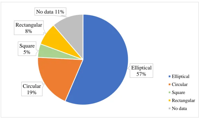
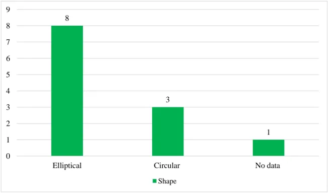
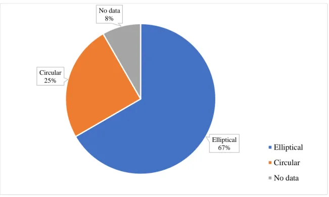
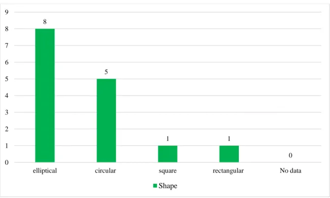
Diagram 1: Shape of the fortified Tells during the EB and MB. ... 117
Diagram 2: Shape of the fortified Tells during the EB and MB (By Percentage). ... 117
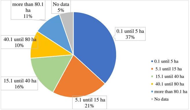
Diagram 3: Size of the fortified Tells during the EB and MB. ... 118
Diagram 4: Size of the fortified Tells during the EB and MB (By Percentage). ... 118
Diagram 5: Size of the fortified cities during the EB and MB. ... 119
Diagram 6: Shape of the fortified cities during the EB and MB. ... 119
Diagram 7: Shape of the fortified Tells in Syrian Jazierh during the EB and MB. ... 120
Diagram 8: Shape of the fortified Tells in Syrian Jazierh during the EB and MB (By Percentage). ... 121
Diagram 9: Size of the fortified Tells in Syrian Jazierh during the EB and MB. ... 121
Diagram 10: Size of the fortified Tells in Syrian Jazierh during the EB and MB (By Percentage). ... 122
Diagram 11: Size of the fortified cities in Syrian Jazierh during the EB and MB. ... 122
Diagram 12: Shape of the fortified cities in Syrian Jazierh during the EB and MB. ... 123
Diagram 13: Shape of the fortified Tells in the Euphrates Region during the EB and MB. ... 124
Diagram 14: Shape of the fortified Tells in the Euphrates Region during the EB and MB (By Percentage). ... 124
Diagram 15: Size of the fortified Tells in the Euphrates Region during the EB and MB. ... 125
Diagram 16: Size of the fortified Tells in the Euphrates Region during the EB and MB (By Percentage). ... 125
Diagram 17: Size of the fortified cities in the Euphrates Region during the EB and MB. ... 126
Diagram 18: Shape of the fortified cities in the Euphrates Region during the EB and MB. ... 126
Diagram 19: Shape of the fortified Tells in the Upper Northern Levant during the EB and MB. ... 128
Diagram 20: Shape of the fortified Tells in the Upper Northern Levant during the EB and MB (By Percentage). ... 128
Diagram 21: Size of the fortified Tells in the Upper Northern Levant during the EB and MB. . 129
Diagram 22: Size of the fortified Tells in the Upper Northern Levant during the EB and MB (By Percentage). ... 129
Diagram 23: Size of the fortified cities in the Upper Northern Levant during the EB and MB. 130 Diagram 24: Shape of the fortified cities in the Upper Northern Levant during the EB and MB. ... 130
Diagram 25: Shape of the fortified Tells in the Lower Northern Levant during the EB and MB. ... 132
Diagram 26: Shape of the fortified Tells in the Lower Northern Levant during the EB and MB (By Percentage). ... 132
Diagram 27: Size of the fortified Tells in the Lower Northern Levant during the EB and MB. . 133
Diagram 28: Size of the fortified Tells in the Lower Northern Levant during the EB and MB (By Percentage). ... 133
XVII
Diagram 29: Size of the fortified cities in the Lower Northern Levant during the EB and MB…
... 134
Diagram 30: Shape of the fortified cities in the Lower Northern Levant During The EB And MB. ... 134
Diagram 31: Towers and bastions in Jazirah, the Euphrates Region, the Upper and Lower Northern Levant during the EB and MB. ... 180
Diagram 32: Functional use of the towers and bastions in Jazirah, the Euphrates Region, the Upper and Lower Northern Levant during the EB and MB. ... 180
Diagram 33: Shape of the towers and bastions in Jazirah, the Euphrates Region, the Upper and Lower Northern Levant during the EB and MB. ... 181
Diagram 34: Towers and bastions during in the Euphrates Region during the EB and MB... 182
Diagram 35: : Shape of the towers and bastions in the Euphrates Region during the EB and MB. ... 183
Diagram 36: Shape of the towers and bastions in the Euphrates Region during the EB and MB (By Percentage). ... 183
Diagram 37: Towers and bastions in the Upper Northern Levant during the EB and MB. ... 185
Diagram 38: Shape of the towers and bastions in the Upper Northern Levant during the EB and MB. ... 185
Diagram 39: Shape of the towers and bastions in the Upper Northern Levant during the EB and MB (By Percentage). ... 186
Diagram 40: Towers and bastions in the Lower Northern Levant during the EB and MB. ... 187
Diagram 41: Shape of the towers and bastions in the Lower Northern Levant during the EB and MB. ... 187
Diagram 42: Shape of the towers and bastions in the Lower Northern Levant during the EB and MB (By Percentage). ... 188
Diagram 43: Gates during the EB and MB. ... 198
Diagram 44: Type of the gates during the EB. ... 199
Diagram 45: Type of the gates during the EB (By Percentage). ... 199
Diagram 46: Type of the gates during the MB. ... 200
Diagram 47: Type of the gates during the MB (By Percentage). ... 200
Diagram 48: Type of the gates in jazirah during the EB. ... 201
Diagram 49: Type of the gates in jazirah during the EB (By Percentage). ... 201
Diagram 50: Gates in the Euphrates Region during the EB and MB. ... 202
Diagram 51: Type of the gates in the Euphrates Region during the EB. ... 203
Diagram 52: Type of the gates in the Euphrates Region during the EB (By Percentage). ... 203
Diagram 53: Type of the gates in the Euphrates Region during the MB. ... 204
Diagram 54: Type of the gates in the Euphrates Region during the MB (By Percentage). ... 204
Diagram 55: Gates in the Upper Northern Levant during the EB and MB. ... 205
Diagram 56: Type of the gates in the Upper Northern Levant during the MB. ... 206
Diagram 57: Type of the gates in the Upper Northern Levant during the MB (By Percentage). 206 Diagram 58: Gates in the Lower Northern Levant during the EB and MB. ... 207
XVIII
Diagram 59: Type of the gates in the Lower Northern Levant during the EB. ... 208 Diagram 60: Type of the gates in the Lower Northern Levant during the EB (By Percentage). . 208 Diagram 61: Type of the gates in the Lower Northern Levant during the MB. ... 209 Diagram 62: Type of the gates in the Lower Northern Levant during the MB (By Percentage). 209 Diagram 63: Ditches during the EB and MB. ... 221
1
PREFACE
The thesis presents a study about the changes that happened on the defensive elements during the Early and Middle Bronze Age in the Euphrates region, Syrian Jazirah the Upper and Lower Northern Levant.
I studied archaeology at the University of Aleppo in Syria, and I have done there my Master degree, during my study, I have done a project with an archaeological team to achieve the ottoman inscription and ottoman buildings in the old city of Aleppo for three years. But the ancient architecture during the Bronze Age was my passion. Therefore, I wrote my MA thesis about the evolution of the Syrian Palace during the Early Bronze Age.
Furthermore, my study let me visit many archaeological sites which dated to varied periods in Syria, I have seen the old civil and military architecture when I saw the enormous earthen rampart surrounding Tell Mardikh / Ebla that gave me a passion for learning more about the fortification structures during the Bronze Age.
Because I read about the political and military events during the Early Bronze Age in Syria that pushed me to connect them with the military architecture, therefore, I applied to study the defensive elements in Syria during the Early and Middle Bronze Age at Sapienza University in Rome. The archaeological studies that monitor the changes on the defensive elements during the Bronze Age in the Euphrates region, Syrian Jazirah, the Upper and Lower Northern Levant are very few. Therefore, this thesis can be considered as the first step towards further studies in the future, which shows the differences that have occurred in the military architecture during varied periods in the Northern Levant.
Be contacted at [email protected] Ali Jabbour
2
ACKNOWLEDGEMENTS
Throughout the writing of this thesis, I have received a great deal of support and assistance. I would first like to thank the head of the department of Antiquity Sciences in the Sapienza University of Rome, Co-Director of Archaeological Expedition to Ebla prof Frances Pinnock for the help and the welcome provided to me.
Moreover, I would like to thank my supervisor, prof Davide Nadali for his guidance through each stage of the process, where we discussed the defensive elements in Tell Mardikh / Ebla. Besides, he provided me with many articles and gave many comments and advice which helped to write my thesis.
I would like to acknowledge to the head of Tell Chuera expedition Prof Jan-Waalke Meyer who explained to me about the fortification structure in Tell Chuera and Kharab Sayyar.
I would like to thank Dr Tobias B. H. Helms for spending time with me discussing the defensive system in Tell Chuera and provided me with some photos and information about the fortification structure in area Win Tell Chuera.
I want to thank Dr Glenn M. Schwartz Professor of Archaeology and Chair Department of Near Eastern Studies Johns Hopkins University who provided me with some articles about Tell Umm el-Marra, and Georges Mouamar who provided me with an article about Tell al-Sür article. I would like to acknowledge my colleagues in Ebla office in the department of Antiquity Sciences at Sapienza University for all of the opportunities/help; I was given to conduct my research and further my dissertation.
In addition, I want to thank my parents and my family in Syria, Belgium, and Germany, for supporting me during my study. Finally, the greatest thanks are due to my wife, Daniela Jabbour, who helped to translate many German articles and books.
3
ABBREVIATIONS
a.s.l Above sea level Alt. Elevation
BC Before Christ cm Centimeter
EB Early Bronze Age ED Early Dynastic period EJ Early Jazirah period ha Hectare
km Kilometer
LB Late Bronze Age m Meter
M. Mardikh
MB Middle Bronze Age MD. Mohamad Diab No. Number
OJ Old Jazirah period Op Operation
S Soundages (sounding) Sq Square
4
ABSTRACT
A. The importance of the research
This work presents a comprehensive study of the Early and Middle Bronze defensive elements (around 3000 – 1600 BC.) in Syrian Jazirah, the Euphrates region, the Upper and Lower Northern Levant (Fertile Crescent), Where it provides a study about the methods of using the defensive elements, their structure, dimensions and their building materials and clarify the changes that happened to them between early and middle bronze age in the regions of the study.
B. The geographical framework
With regards to the geographical framework of this research, the core area of research concerns the Fertile Crescent; which consists four geographical regions: Syrian Jazirah, middle and upper Euphrates, Upper Northern Levant (northern Syria and southern Turkey) and Lower Northern Levant (southern Syria and Lebanon) between Mediterranean Sea in the west until Euphrates to the east and Syrian desert (Badia) 1 to the east -south, as illustrated in(Fig. 1- 2).
We should mention that the Northern Levant has been subdivided into two halves, termed here lower and upper based on two factors.
The first is the flow of the Orontes river and the second is the elevation of the upper half, which constitutes a large uplifted block with mountain ranges the Lebanon and anti-Lebanon that are higher in elevation than the lower half, the division of the lower and upper regions of the Northern Levant is Homs Gap.2
C. The chronological framework
In regards to the chronological framework of this research, it extends from the Early bronze age until the end of the Middle Bronze age, (around 3000 – 1600 BC.) The transition from the Early to the Middle Bronze Age represented a period of significant social and cultural change in many parts of the Near East, the archaeological record of this transitional period was characterised by changes in settlement patterns, the emergence of new cultural traits, and abrupt settlement destruction and abandonment. Explanations have ranged from foreign invasions or penetration of new (ethnic) groups to system collapse.3 The war to obtain resources and to expand one’s sphere of political control, 4 therefore, the regions of the study have witnessed many conflicts and the military events, which are reflected in one way or another on the fortification structures of the cities.
1 Semi-arid steppe or desert with an average rainfall below 200 mm per year (Akkermans, Schwartz 2003: 6). 2 Steiner, Killebrew 2014:11.
3 Wossink 2009: 2. 4 Liverani 2014: 23.
5
D. The aim of the research
1- Define the defensive elements that have been used to fortify the cities during the Early and middle bronze age in the regions of the study.
2- Analysis and study their structure; specifically, their dimensions, their shapes, building materials which have been used to build them and their functional use.
3- Study and clarify the changes that happened to them between the Early and Middle Bronze Age. a. Size and shape.
b. Building materials. c. Functional use.
4- Present an accurate statistical study of the fortified cities and their defensive elements.
5- Clarify how the defensive elements have been used in different ways from a city to another, moreover, how these elements were working together as one defensive unit to protect the cities against the invasion.
6- Study the correlation between the size of the settlements and the kind and width of the defensive elements that have used to fortify them.
7- Clarify the features and aspects of the fortification structures in the regions of the study, which includes the kind of the defensive elements that have been used to fortify the cities and the building materials that have been used to build the fortification structure (wall- rampart), moreover, the methods of using the fortification walls, the types of gates and the methods of using the towers and bastions, furthermore, the shape of the settlements
8- Clarify the reasons behind of fortifying and reinforcing some cities more than others, and how some cities have continued fortified from the EB to MB and other cities have become abandoned during the EB, whether due to natural disasters or the military invasion.
E. The method of the study / Research Methodology
Beside of the geographical and chronological parts, the defensive elements have studied through their methods of using because they were used in different ways.
Such as the ramparts, which have surrounded in some settlements the entire upper and lower cities, while in other settlements have fortified a part of the upper and lower cities, sometimes they have been used alone, or they were reinforcing the fortification walls.
The methods of the study the defensive elements have gone through three axes: - Period; which is consisted of the Early and Middle Bronze Age.
6
- Methods of using defensive elements, their dimensions and their building materials.
Then we have clarified the differences between these elements during the Early and Middle Bronze Age, how have they changed.
The thesis is divided into four chapters:
In order to be able to consider the types of defensive elements and the changes that happened to them, the first chapter presents a study about the structure of the defensive elements, their dimensions and building materials and clarifies the changes that accrued to them between EB and MB and attempt to answer the reasons of those changes.
The second chapter presents an accurate statistical study attached to tables and diagrams for the studied defensive elements in the first chapter, which contains:
-
Shape and size of the Tells.-
Fortification walls, rampart, glacis, revetment, retaining and casemate walls.-
Towers and bastions.-
Buttresses.-
Gates.-
Forts and fortresses.-
Ditches.While the third chapter presents a study to clarify the correlation between the size of the settlements and the kind and width of the defensive elements that have used to fortify the cities.
Moreover, we have clarified the features and aspects of the fortification structure in the regions of the study, which includes the kind of defensive elements and building materials have used in each region, method of using the fortification walls, towers and bastions, type of the gates and shape of the Tell in each region.
We have elucidated the reasons behind of fortifying and reinforcing some cities more than others, and how some cities have continued fortified from the EB to MB and other cities have become abandoned during the EB, whether due to natural disasters or the military invasion.
The last chapter presents the fortified settlements during the Early and Middle Bronze Age, which were excavated in the regions of the study.
7
GEOGRAPHICAL BACKGROUND
Preface
A landscape approach helps us recreate the historical landscape in which the fortifications were originally built. It includes a multitude of types of analysis, which can help us understand the factors that commanded the construction of walls at a given place. 5 The development and location of human settlements, the accumulation of surplus, craftsmanship, and trade had a strong influence on the history of the area despite their relatively limited scale, consequently, a secluded and protected area, well connected to its surroundings, could experience a more effective and productive development than a larger, but fragmented area.6
The environmental diversity of the Near East caused its population to be distributed more unevenly than today. Communities mainly settled in the alluvial plains and the intermontane niches. In some phases, they even moved into vast hilly areas and plateaus and avoided the mountains and steppes, which were accessible on a seasonal basis, and by smaller, nomadic communities.
Therefore, even within these densely populated areas, the discontinuity of population levels remains, with irrigated patches of land (cultivated by sedentary and even urbanised communities) emerging from a territory potentially exploitable, but largely left uncultivated.7 Therefore, it is essential to understand the geographical context, because it affects directly or indirectly on the town architecture, especially the defensive system, the Levant8 consists of a stretch of the
south-western Asia that forms a natural land bridge between Asia and Africa. Three prominent components define this general area from west-to-east: the Mediterranean, the great Syro-African Rift, and the vast desert expanse to the east.9
Geographically as well as geologically, the northern Levant and Jazirah can be divided into zones that are roughly aligned along an east-west axis. Bordering the Mediterranean Sea is a narrow coastal strip that until recent times was insalubrious and very sparsely settled. To the east, the land rises up to the mountain ranges of the Amanus, Jebel Ansariya and Libanon. Continuing to the east, the land descends into the valleys of the Orontes and the Jordan Rivers, and rises up again into the lower mountain ranges of the Jebel Samane, Zaouiye, Anti-Libanon and Hermon. Finally, the large flat steppes of inner Syria are reached, which stretch eastwards to the Zagros Mountains and are bordered by the Taurus in the north. These flat steppes are intersected by several rivers, of which the Euphrates and Tigris are the most important ones. Between these two rivers lies the area that is today known as the Jazirah.10
5 Fachard 2016: 416. 6 Liverani 2014: 19. 7 Liverani 2014: 22.
8 The term levant covers an area that is often referred to archaeological works by other term most notably Syria-Palestine and North Syria (Steiner, Killebrew 2014: 9).
9 Steiner, Killebrew 2014: 9. 10 Wossink 2009: 8.
8
We should mention that there is a difference in the overall disposition between the Upper and Lower Northern Levant. The upper is a spreading land opening onto other territories to the east and to the north; the lower is more particularised, compacted between sea and desert continuous only to its northern extension.11
The northern levant has often styled a "crossroads of civilisation." Located at the intersection of major traffic routes of the eastern Mediterranean and Near East, the region was traversed by caravans and military expeditions moving between the economic and political poles of the ancient Near Eastern world, from Egypt to Anatolia, from the Mediterranean to Mesopotamia.12
The project focuses geographically about the fortified settlements of the ‘Fertile Crescent’, namely, a semicircle of fertile irrigated lands prone to agricultural and urban settlements extending from the northern Levant to (Lebanon and western Syria) to middle and upper Euphrates and northern Mesopotamia (Syrian Jazirah), as illustrated in(Fig. 1- 2).
A. Northern Levant (upper and lower region)
It is extended from southern Turkey to western Syria and Lebanon, the northernmost range is the Amanus, in what is now the Turkish province of Hatay, to its south are two parallel north-south ranges, the Jebel Ansari yah to the west (1575 m maximum elevation) and Jebel Zawiyah to the east, with the Ghab depression situated between them (Fig. 3- 4).
The Horns (or Akkar) gap separates those two ranges from their counterparts to the south, the Lebanon and Anti-Lebanon (2700 m max. elevation) ranges, primarily in present-day Lebanon. Between the Lebanon and Anti-Lebanon mountains lies the Beqa'a valley.13 The gaps between the
mountain ranges are strategic and agriculturally significant zones allowing access between regions. Separating the Amanus from the Ansari yah and Zawiyah ranges is the Amuq (Antioch) plain, watered by the lower reaches of the Orontes River. A small gap through the Jebel Ansariyah is located east of Ras Shamra, but more significant is the Horns/ Akkar gap between the Ansariyah/Zawiyah and Lebanon/Anti-Lebanon ranges. Given its considerable extent, the Horns gap provides the easiest access between the Mediterranean coast and the Syrian interior.14
A narrow littoral, the Mediterranean coastal plain is bounded on the east by Lebanon, Jebel Ansariyah, and Amanus ranges. Relatively humid, the coast now receives an average of 600-1000 mm annual rainfall and was originally wooded. Also forested before the onset of human-induced deforestation, the mountain ranges parallel to the coast receive over 1000 mm of average annual precipitation. Both areas are characterised by Mediterranean Terra Rossa soils and are conducive
11 Wright 1985: 5
12 Akkermans, Schwartz 2003: 2. 13 Akkermans, Schwartz 2003: 4. 14 Akkermans, Schwartz 2003: 4.
9
to the cultivation of Mediterranean crops such as olives, figs, and grapes, given the availability of cultivable land.15
Because the coastal mountain ranges largely impede the movement of precipitation from the west, the plains to the east are much drier than the coast. The west Syrian interior, sometimes designated as a semi-arid steppe, nevertheless enjoys enough rainfall (200-400 mm annually) to support dry-farming agriculture traditionally characterised by winter wheat cultivation (i.e. winter planting, late spring harvesting). Olives and grapes are also cultivable in much of this region. In the north are the agricultural plains surrounding the city of Aleppo, bisected by the north-south flowing Qoueiq river.
Further south is the upper Orontes valley, whose dry-farming agricultural capabilities engendered the urban centres of Hama and Horns, occupied for many millennia like Aleppo. In the regions west and southwest of Aleppo are limestone plateaus that historically supported olive groves; here the "Dead Cities" of the Byzantine period are located.16
The major river of western Syria is the Orontes (Nahr al-Asi), which originates in the Anti-Lebanon mountains and proceeds north through the Horns gap past Horns and Hama. Although the river is unnavigable, it can furnish water for irrigating gardens and orchards the river twists to the west and makes its way between the Jebel Ansariyah and Jebel Zawiyah mountains, creating the marshy but fertile Ghab depression with its alluvial soils. Northeast of the Ghab is another agriculturally prosperous enclave, the Rouj basin Continuing north into the Amuq plain, the Orontes makes one last curve to the west and passes between the Amanus and Jebel Ansariyah to reach its final destination in the Mediterranean.17
To the south the Anti-Lebanon mountains inhibit the movement of precipitation to the east, resulting in the dry steppe north of Damascus. Damascus itself, however, is situated in the al-Ghutah oasis created by the waters of the Barada river, originating in Anti Lebanon. Often dubbed the "oldest continuously occupied city in the world," Damascus could easily share the title with Aleppo or Hama, reflecting both the early appearance of urbanism in Syria and its relative stability over a long time.
Unfortunately, the massive accumulation of settlement deposition in such long-lived centres has made an investigation of their pre-Hellenistic remains decidedly difficult, with a few exceptions like the Hama citadel. South of Damascus is the Hawran basalt plateau, a region of substantial fertility owing to the decomposition of its volcanic rock, with the Jawlan (Golan) region located to the west.18
15 Akkermans, Schwartz 2003: 4. 16 Akkermans, Schwartz 2003: 4. 17 Akkermans, Schwartz 2003: 4-5. 18 Akkermans, Schwartz 2003: 5.
10
In southeastern Syria, we find the driest part of the country, a semi-arid steppe or desert with an average rainfall below 200 mm per year, the region sustains enough plant life to support herbivores, however, and it has traditionally served as grazing land for mobile pastoralists.19
B. Euphrates region
The Euphrates River begins its long journey in the highlands of eastern Turkey, where its headwaters are fed by rainfall and melting mountain snow, in its 1400 km journey through the Syrian plateau, is characterised by a meandering channel that flows through a deep valley, 4-12 km wide. On either side of the valley, rising up to 80 m above the Euphrates floodplain, are the escarpments of two deserts.20 The Syrian desert to the west, which constitutes a rocky and hilly area with little vegetation except for short grass and scattered shrubs, extends to the Orontes valley, to the east, the undulating, stony plain of the Jazirah desert extends as far as the Tigris valley and north to the outliers of the Taurus mountains (Fig. 5).21
After a steep descent through Anatolia, the Euphrates enters Syria just below the ancient city of Carchemish. As it flows through northern Syria, the river’s meandering channel is contained within an alluvial plain that is as wide as 10 km in some places, while in other areas, it flows through long, narrow gorges featuring flood plains no wider than 500 m, surrounded on both sides by precipitous limestone bluffs that rise up over 100 m.22 Where the river valley is wider, and the channel is less deeply entrenched, minor streams break off and rejoin the main channel between lengths of 3 and 6 km. The river may also occasionally break through its meanders, causing a shift in the course of the channel altogether. In such cases, ancient settlements that were once situated near the river’s edge have either been completely erased by river erosion or obscured by sedimentation.23
In other cases, sites are situated on the edges of relict channels, which lie at a considerable distance to the present river course.24 The annual flooding in spring would have inundated many of the fields
of the adjacent flood plain where flooding coincides with the agricultural growing season, and freshwater and alluvial soil are welcomed as much needed nourishment for crops. The Euphrates flooded at precisely the wrong time of the year when cereal crops were beginning to ripen, and large volumes of water were no longer required for their growth. Such poor timing clearly made winter-spring farming on the flood plain a high-risk venture.25
19 Akkermans, Schwartz 2003: 6. 20 Cooper 1997: 12. 21 Cooper 1997: 12. 22 Cooper 2006: 28. 23 Cooper 2006: 28. 24 Cooper 2006: 28. 25 Cooper 2006: 29.
11
Furthermore, we can notice that in the Tabqa area the Euphrates floodplain is sub-divided into a low terrace at c. 4 m above the river level and a slightly higher terrace at c. 6 m. Before dam construction, this difference of 2 m placed the 6 m flood plain terrace just above the most frequent floods.26Consequently, most crops were grown on the gently sloping river terraces elevated several meters above the flood plain, safely beyond the limits of the annual inundation.
The Euphrates valley is flanked by a staircase of alluvial terraces27 on both right and left banks which have different manifestations and sequences depending upon the local histories of deposition, incision and erosion; 28 these plains provided other natural resources in abundance. The vast grassy upland plateaus, extending away from either side of the valley, provided the potential for flourishing pastoral activities and they abounded in wild game. Trading opportunities afforded by the Euphrates River itself opened up the region to long-distance contacts. Such commercial relations were responsible for the procurement of surplus goods as well as foreign influences and cultural exchanges.29
We can see that the natural landscape of the Euphrates River valley of northern Syria, extending for approximately 100 km from the modern Turkish-Syrian border in the north to the region below the Tell Meskene/ Emar in the south. Presents a sharp contrast to the dry, deserted land that surrounds it, through the lonely expanse of the treeless, undulating steppe land of the northern Syrian plateau, the Euphrates River cuts a deep trough, creating a fertile valley of alluvial plains and terraces on either side of its banks.30
The navigable waterways of the Euphrates River provided an effective means of communication, enabling economic and cultural links between the inhabitants of this otherwise isolated region and people of other populated, cosmopolitan regions of Mesopotamia, Anatolia and the Levant. 31 Some settlements were near to the river as Jerablus Tahtani; it is possible that the sites’ proximity to the river allowed them to take advantage of economic opportunities afforded by commercial traffic along the river. Alternatively, the strategic location of these sites at key crossing points over the river may have enabled them to control overland caravan traffic arriving from points to the east and west. On either side of the river, a series of terraces gently slopes down towards the flood plain. These are the dry remnants of the large and oldest channels of the river, formed during the mid-to-late Pleistocene Era.32
Composed of chalky white limestone bedrock superimposed by a layer of brown limestone, river gravels and silty soil, the terraces now stand several meters above the level of the alluvial plain.
26 Wilkinson et al. 2012: 146.
27 Research applying radiometric dating techniques to basalts inter-stratified with selected terrace gravels, have pushed the dates of the earlier stages of the river back to some 3 million years ago, (Wilkinson et al. 2012: 145).
28 Wilkinson et al. 2012: 145. 29 Cooper 2006: 27.
30 Cooper 2006: 28. 31 Cooper 2006: 28. 32 Cooper 2006: 29.
12
Since they are safely above potentially destructive flooding events, they are favourable places to practice dry farming. On the western side of the Euphrates, the upland plateau extends in the direction of western Syria, while on the river’s eastern side, the uplands comprise what is known as the Jazirah, a vast undulating upland steppe that extends all the way across northern Syria into northern Iraq, where it reaches the Tigris river.33
C. Syrian Jazirah
Located in northeast Syria, the Jazirah is part of the Arabian plate that slopes down towards the east. We can observe that the northern Jazirah consists of flat plains, with few striking relief features, of these, the Jebel Abd el-Aziz and the Jebel Sinjar are the most marked, with heights of 920 and 1480 m respectively,34 as indicated in (Fig. 2 -6 -7).
Using both rainfall and geological data, Reifenberg described the soils of the Jazirah for those regions receiving less than 200 mm of precipitation annually as desert soils, and as Mediterranean steppe soils and alluvial Mediterranean steppe soils those areas receiving more than 200 mm. The northern half of the Jazirah is characterised by calcareous soils, whereas to the south gypsiferous soils dominate. In the northeast corner of the Jazirah, reddish-brown loams on igneous rock occur,35 The rainfall allows tentative dry farming immediately north of the Jebel Abd el-Aziz and the Sinjar (350-400mm). The north part of the region benefits from more regular rainfall and is in the typical dry farming zone (400-650mm).36 But soil micromorphological studies at and around Tell Leilan indicated the occurrence of an abrupt dry phase from 2200–1900 BC, possibly caused by an otherwise unidentified volcanic eruption, this evidence was supported by indications for drought elsewhere, notably Egypt, this drought led to the abandonment of urban settlements in the area around Tell Leilan including Tell Leilan itself.37 some towns have been abandonment as resulted of changing climate especially northern Mesopotamia during the Early and Middle Bronze Ages (c. 3000–1600 BC).38
That means the changing in the climate has been reflected in the towns which were founded during the EB and MB, led to change in the demography, the social organisation of human societies and socio-cultural changes all of that has been reflected in the architecture for these towns. Because when the climate became drier during the late third to early second millennium BC, that means the agriculture has been negatively affected, and there was a lack of, consequently the town had to protect their crops from the looting that force them to build a strong defensive system around the settlements. Rivers and wadis in the northern Jazirah have cut into the plains, resulting in relatively
33 Cooper 2006: 31. 34 Wossink 2009: 8. 35 Wossink 2009: 8. 36 Lebeau et al 2011: 3. 37 Wossink 2009: 2. 38 Wossink 2009: 6.
13
shallow valleys. Most of the rivers and wadis drain into the Euphrates. The Khabur and Balikh are the most prominent of these rivers. 39
The Khabur is fed by the karstic springs of ‘Ras al-Ain and is joined by multiple wadis including the Wadi Jaghjagh40 and Wadi Radd, creating the Khabur Triangle, 41 The Khabur river in its central valley traces its course between the Jebel Abd el-Aziz and Sinjar mountain ranges. North of those ranges, no physical barrier interrupts long-distance sight in this fat country; some geographical elements allow the traveller to locate himself like the Mardin breach. North of Tell Mozan, and the Kawkab volcano, close to the modern town of Hasakah.42
The Khabur River permits cultivation along its banks and chose of its tributaries, spread out like a fan. Contributing to the prosperity of the region, once rainfall is sufficient to assure intensive agriculture. The Khabur and its tributaries constitute the principal landmark in the region. All settlements are located along watercourses.43
39 Wossink 2009: 8.
40 Today, the Wadi Jaghjagh is an intermittent stream, but it carried water permanently until quite recently. (Wossink 2009: 8). 41 Wossink 2009: 8.
42 Lebeau et al 2011: 3. 43 Lebeau et al 2011: 4.
14
HISTORICAL BACKGROUND
The conflicts and the military events during the Early and Middle Bronze Age
Early Bronze Age
Early Bronze Age society, from its inception, was to focus on the land and its bounty, on communal action, and on relatively egalitarian manifestations of material wealth and wellbeing. In this sense, early EB I could be seen as the beginning of a trajectory. where at the start of the third millennium, the northern Levant specifically western Syria was not yet coveted for its resources, nor did it have any intermediary role in the relations between east and west, or between north and south. But that had changed with the establishment of the 'Byblos run' (the sea route between Asia and Egypt).44 The establishment of long-distance interaction along the coast doubtless brought western Syria into the purview of the rapidly growing economies of the Upper and Middle Euphrates Although the evidence for trade connections between Anatolia or Mari and western Syria does not seem to pre-date the mid-third millennium, the recognition that this area could be a hub of sea trade between western Asia, Cyprus, and Egypt must have its roots in this period.45
The latter part of the Early Bronze Age (EB IV in the Northern Levant) was characterized by a 'second urban revolution' in the north. Tell Mardikh/Ebla is the epicentre of the new urban order in the northern Levant, but the spread of northern Levantine urbanization was rapid and thorough, creating a new landscape of towns and dependent villages.
There can be little doubt that a significant element in the 'explosion' of settlement in western Syria and the concomitant meteoric rise of the kingdom of Ebla is the increased interest of Mesopotamian polities in the region. The success of Ebla attracted competition and violent confrontations with Mari and with Akkadian kings.46
The final centuries of the third millennium set the stage for the transformations of the second millennium BC, which represented a period of significant social and cultural change in many parts of the Near East, the archaeological record of this transitional period was characterised by changes in settlement patterns, the emergence of new cultural traits, and abrupt settlement destruction and abandonment. Explanations have ranged from foreign invasions or penetration of new (ethnic) groups to system collapse.47 The war to obtain resources and to expand one’s sphere of political control,48 especially as I mentioned the climate has been changed and became drier during the late EB, therefore, the invasion to obtain resources, considered a solution for some towns.
44 Greenberg 2014: 272-274. 45 Greenberg 2014: 274. 46 Greenberg 2014: 275.
47 Wossink 2009: 2. 48 Liverani 2014: 23.
15
So, the relations between commercial networks were difficult to maintain, since each network was striving to grow at the expense of the others, and more than one centre was competing for the control of the same network. From here, we understand the importance of the defence system for protecting the settlements from looting and invasion. Therefore, these settlements have been fortified.
So, during the EB the most important aspect was fundamental for the functioning of a state was the use and monopoly of defence forces to protect internal cohesion. The wealth and technical knowledge accumulated in cities had to be defended against foreign attacks, both from other city-states and other enemies (for instance, nomadic tribes). This defence system then turned into an offensive tactic. The latter was aimed at getting hold of products.49
A. The conflict between Ebla and Mari
Syria was neither a political entity of its own. We can see that clearly in the conflict between Ebla and Mari was rooted in their respective position in the commercial network of the area. Mari was a crucial commercial junction between Lower Mesopotamia and Syria. Ebla controlled those territories50 that would have allowed the expansion of Mari’s commercial network further west, Ebla is clearly documented as an administrative and economic centre at least for inland northern Syria. It was in control of a section of the trade route between Mesopotamia and central Syria.51 Ebla’s position prevented the rise of Mari as a political and economic power in western Syria. Mari was therefore significantly hindered by Ebla, a fact that may be reflected in its alternation of two strategies.
The first one was a military strategy against Ebla, aimed at stopping its commercial supremacy in western Syria.52 The second one was a diplomatic one, aimed at exercising an influential position on the south-eastern trade routes, that has been confirmed by the text TM 75.G2367 which interpreted as a military bulletin from Ebla or an introducing letter from Mari. The text refers to military operations of the rulers of Mari in the Euphrates region and an expansion of the influence
49 Liverani 2014: 80.
50 The kingdom did not reach the Mediterranean coast, ruled by several independent kingdoms such as Byblos, which must have been the most influential one. Similarly, the Eblaite kingdom did not control the Euphrates Valley, where there were several autonomous states, from Carchemish to Emar, Tuttul and Mari. In the south, Ebla did not extend beyond Hama, and bordered with the kingdom of Ibal (near Qatna). Even in the north, the kingdom did not extend beyond Aleppo, where there were other
independent states.
Therefore, the kingdom of Ebla was more a large state than a regional one. However, its territory was larger than the one of contemporary Mesopotamian states and with a population of a similar size. However, the lower density of population effectively compensated for the larger size of the Eblaite kingdom, Ebla was a hegemonic centre in the area, and it controlled several of the surrounding states, both politically and economically. Nevertheless, the supremacy of Ebla in the area experienced several fluctuations. At the peak of its expansion, Ebla controlled the Euphrates Valley (from Carchemish to Emar), the Balikh Valley (with the Harran and Irrite kingdoms), and the Taurus foothills (with the Urshum and Hashshum kingdoms, near Gaziantep). (Liverani 2014: 121).
51 Klengel 1992: 26. 52 Liverani 2014: 118.
16
of Mari upstream as far as Emar and Hazuwan/Hashum, before Ebla could regain its influence there.53
However, Ebla and Mari were not the only centres in the Upper Mesopotamian regional system: there were also Nagar (Tell Brak), located in the Khabur basin, Armi in the Upper Euphrates, and Kish, a hegemonic power in Middle Mesopotamia at the time.54 Ebla’s alliance with Nagar and Kish against Mari and Armi at the time of the final conflict between the two cities clearly indicates this political and commercial situation (nearby cities being enemies of each other, and forming alliances with cities located around their enemies). 55
That initially Ebla was under the supremacy of Mari. In fact, following the victorious campaigns of Iblul-Il, the king gained control over the Euphrates Valley and Ebla itself, which had to pay substantial tributes. The situation dramatically changed under Ibrium. He led several campaigns against rebellious vassal-rulers, and more demanding campaigns against Abarsal (at the time of Arrukum), Halsum, Kakmium, and the powerful Armi (on the Upper Euphrates). 56
Apart from continuing the first in the north, Ibrium’s son and successor Ibbi-Zikir led some military expeditions to the south (against Ibal). He also fought against Mari through an alliance with Nagar and Kish (which sent their military contingencies). 57
The war ended with a battle near Terqa, where Mari was defeated, and its supremacy removed. Alongside the military and territorial expansion of Ebla, Ibrium and Ibbi-Zikir also increased the kingdom’s commercial activities, with a ten-fold increase in investments compared to previous periods,58 This is indicated by TM.75. G2420, considered to be a treaty between Ebla and Ashur or between Ebla and Abarsal, a place or territory different from Ashur. The treaty concerns the trading activities of merchants from Ebla in the area of the Euphrates or the Habur.59
Having defeated Mari, Ebla never sought to destroy it and preferred to seal an alliance. This decision was possibly made for commercial reasons since Ebla was not able to control commercial relations with the east on its own. Moreover, Mari was in a crucial position to control Kish, whose rise under Sargon initiated that expansionistic policy which would characterize the dynasty of Akkad. However, due to a series of events unknown to us, Mari managed to recover from the defeat
53 Klengel 1992: 28. 54 Liverani 2014: 118. 55 Liverani 2014: 119. 56 Liverani 2014: 122. 57 Liverani 2014: 122. 58 Liverani 2014: 122. 59 Klengel 1992: 29.
17
and to attack Ebla,60 conquering it and sacking its palace,61 after the destruction of the Ebla of Palace G, the city and its entire territory experienced a period of crisis.
B. Invasion of the Akkadian empire Upper Land’ the Khabur and Middle Euphrates region and Armanum and Ebla
Sargon king of Akkad ca. 2340–2284 BC / EB IVB,62 was a war hero, he founded the Akkadian empire, that led to Considerable changes also appeared in the realm of political and military interventions (with an empire that actually managed to reach the Lower and the Upper Sea), in the second phase of the empire’s formation was more focused on the re-organisation of commercial routes reaching outside Mesopotamia, rather than on military campaigns. Beyond the Euphrates delta, in the Lower Sea. Further north along the Euphrates, Sargon had to stop at Tuttul.63 Only the god Dagan would grant him access to resources from Mari, Yarmuta, Ebla and the Upper Euphrates region, including the ‘cedarwood’ and the ‘mountains of silver64 (the names
conveniently given to the Amanus and Taurus regions). Sargon was therefore quite honest, stating that he controlled the area from Tuttul to the Persian Gulf, while his commercial network stretched from the Mediterranean to Magan and Meluhha. 65
The successor of Sargon, Rimush (2284-2274) his influence appears in upper Mesopotamia, at least as is indicated by the archaeological material from Tell Brak.66 With Naram-Sin 2259–2223 BC / EB IVB, 67 the grandson of Sargon and Manishtusu’s successor.68 The empire not only did not collapse but experienced a new surge of expansion. He attributes to himself the title of a ruler of the land "Subartum" in northern Mesopotamia as far as the "Cedar Forest'', which is defined as the Amanus. Naram-Sin boasts to have been the first to subdue Arman and Ebla; he took the ruler
60 This is the most probable hypothesis for the destruction of Ebla. Another suggestion is that Sargon destroyed Ebla, but this seems less plausible. First of all, Sargon himself, celebrating his conquests in the Middle Euphrates, declared that he stopped at Tuttul, while the god Dagan granted him access to the west (Ebla above all).
Therefore, Sargon only gained access to the commercial networks of the west. After all, the destruction of a wealthy city such as Ebla would have been celebrated in an entirely different way.
Moreover, when, a couple of decades later, Naram-Sin declared his destruction of Ebla (evidently the city that was rebuilt after the time of the Palace G archives), he would state that the achievement was unprecedented, something that he could not have said if Sargon had destroyed the city first. Finally, we know that Sargon conquered and destroyed Mari only a decade after the fall of Ebla, making its destruction militarily impossible with a still powerful Mari in the way. (Liverani 2014: 122).
61 Liverani 2014: 122. 62 Klengel 1992: 31. 63 Liverani 2014: 135. 64 Klengel 1992: 33. 65 Liverani 2014:135. 66 Klengel 1992: 34. 67 Klengel 1992: 31.
68 Rimush is son Sargon and the first successor to his father and Manishtusu is the second son Sargon and brother Rimush was the second successor and Naram Sin was the third successor (Liverani 2014: 135).