On: 17 October 2013, At: 06:56 Publisher: Taylor & Francis
Informa Ltd Registered in England and Wales Registered Number: 1072954 Registered office: Mortimer House, 37-41 Mortimer Street, London W1T 3JH, UK
Journal of Maps
Publication details, including instructions for authors and subscription information:
http://www.tandfonline.com/loi/tjom20
Geological map of Tuscany (Italy)
Luigi Carmignani a , Paolo Conti a , Gianluca Cornamusini a & Altair Pirro aa
Center for GeoTechnologies and Department of Environment, Earth and Physical Sciences , University of Siena , Siena , Italy Published online: 16 Jul 2013.
To cite this article: Luigi Carmignani , Paolo Conti , Gianluca Cornamusini & Altair Pirro (2013) Geological map of Tuscany (Italy), Journal of Maps, 9:4, 487-497, DOI: 10.1080/17445647.2013.820154
To link to this article: http://dx.doi.org/10.1080/17445647.2013.820154
PLEASE SCROLL DOWN FOR ARTICLE
Taylor & Francis makes every effort to ensure the accuracy of all the information (the “Content”) contained in the publications on our platform. However, Taylor & Francis, our agents, and our licensors make no representations or warranties whatsoever as to the accuracy, completeness, or suitability for any purpose of the Content. Any opinions and views expressed in this publication are the opinions and views of the authors, and are not the views of or endorsed by Taylor & Francis. The accuracy of the Content should not be relied upon and should be independently verified with primary sources of information. Taylor and Francis shall not be liable for any losses, actions, claims, proceedings, demands, costs, expenses, damages, and other liabilities whatsoever or howsoever caused arising directly or indirectly in connection with, in relation to or arising out of the use of the Content.
This article may be used for research, teaching, and private study purposes. Any substantial or systematic reproduction, redistribution, reselling, loan, sub-licensing, systematic supply, or distribution in any form to anyone is expressly forbidden. Terms & Conditions of access and use can be found at http://www.tandfonline.com/page/terms-and-conditions
SCIENCE
Geological map of Tuscany (Italy)
Luigi Carmignani, Paolo Conti∗, Gianluca Cornamusini and Altair Pirro
Center for GeoTechnologies and Department of Environment, Earth and Physical Sciences, University of Siena, Siena, Italy
(Received 22 November 2012; Resubmitted 3 June 2013; Accepted 25 June 2013)
The main map covers the territory of the Tuscany Region, in Central Italy and shows the main stratigraphic and tectonic features of the internal part of the Northern Apennines. This is characterized by nappe superposition well exposed in the Apennine chain (in the eastern part of the map), as well the effects of post-nappe extensional tectonics, originating in Miocene-Pliocene and younger basins bordered by metamorphic core complexes, covering most of the central and southern part of the Region. The map is at 1:300,000 scale and is based on 1:10,000 field mapping. Keywords: geology; stratigraphy; tectonics; Northern Apennines; Tuscany; Italy
1. Introduction
In 2002 the Geological Survey of the Tuscany Region (Florence, Italy), started a project aimed at mapping the whole Region at 1:10,000 scale. The area is about 23,000 km2and consists of 735 map sheets at 1:10,000 scale. For field work, mapping, map compilation and digital delivery (geodata-bases), maps were produced at three universities in Tuscany (Florence, Pisa and Siena) and the C.N.R. (Consiglio Nazionale delle Ricerche). Many researchers were involved in the project over a five-year period. The Geological Survey of the Tuscany Region faced problems with consist-ency due to the lack of a common geological legend and coordination during field work. If the areas mapped by different geologists are compared, often: (a) different formation names were used for the same stratigraphic unit; (b) the same formation name was used for different lithostratigraphic units; (c) different interpretations of the regional significance of the main tectonic features (overthrusts vs. low-angle normal faults); (d) different extent of mapped Quaternary deposits (e.g. adjacent maps with the same rock types, differing extents of landslides and Quaternary cover).
In 2008 the Geological Survey of the Tuscany Region charged the Center for Geotechnologies of the University of Siena to compile a new version of the 1:10,000 scale maps for the entire Region, updating the maps produced during the 2002 – 2007 project, with further field work. According to the specifications of the new project, the 1:10,000 maps must have: (a) a single geo-logical legend; (b) no mismatch at map borders, in terms of both geogeo-logical formation names or tectonic contacts; (c) homogeneous distribution of Quaternary cover and landslides; (d) a fully digitized format and be freely available as PDF file or viewed with Web-GIS services. This work was completed in 2011. The presented Geological Map of Tuscany at 1:300,000
#2013 Paolo Conti
∗Corresponding author. Email:[email protected]
Vol. 9, No. 4, 487 – 497, http://dx.doi.org/10.1080/17445647.2013.820154
scale is one of the products of the project (see Main Map for this paper: Carmignani L., Conti P. and Cornamusini G., Geological Map of Tuscany, Italy, 1:300.000 scale).
2. Geological overview
The Northern Apennine is a fold-thrust belt built during the Tertiary by the collision between the Apulia (or Adria) microplate related to the African plate, and the Brianc¸onnais microplate (Sar-dinia-Corsica block), related to the European plate (Figure 1). The following provides a short overview of the geology of the area; for more information and extensive literature the following papers are of interest:Boccaletti, Gianelli, and Sani (1997), Jolivet et al. (1998), Sani, Moratti, and Bonini (1998),Carmignani, Decandia et al. (2001),Finetti et al. (2001),Carmignani et al. (2004), Rossetti, Faccenna, Jolivet, Goffe´, and Funiciello (2002), Cerrina Feroni, Ottria, and Ellero (2004),Molli (2008) andArgnani (2009). An overview of the main geodynamic and tec-tonic events in the Northern Apennines area is shown in Figure 2.
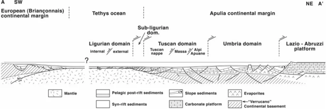
In Tuscany there is complete outcropping of the nappe stack of the Northern Apennines. From the bottom the following are exposed: the Tuscan Metamorphic Units, the Tuscan Nappe, the Sub-ligurian Units, The Ligurian Units, the EpiSub-ligurian Succession, the post-orogenic sedimentary succession starting from Middle Miocene to Quaternary. All these tectonic units are derived from the Apulia continental margin and the Tethys oceanic realm (see Figure 3) and were emplaced during Tertiary subduction and continental collision.
The oceanic realm is named in the Italian geologic literature as ‘Ligurian Domain’, and is part of the Alpine Tethys (Bortolotti, Principi, & Treves, 2001; Elter, 1975;Elter, Elter, Sturani, & Weidmann, 1966;Elter & Pertusati, 1973;Marroni, Molli, Ottria, & Pandolfi, 2001). It is further-more subdivided:
(1) Internal Ligurian Domain, characterized by Jurassic ophiolites and their Late Jurassic-Cretaceous sedimentary cover (cherts, Calpionella limestone and Palombini shales) associated with a Cretaceous-Paleocene siliciclastic turbidite sequence (Lavagna shales, Gottero sandstones and Bocco/Colli-Tavarone shaly complex).
Figure 1. Plate reconstruction for the western Mediterranean area, afterStampfli et al. (1998),Stampfli, Borel, Cavazza, Mosar, & Ziegler (2001), from Carmignani, Conti, Cornamusini, and Meccheri (2004) modified. Slightly different plate reconstruction is proposed also byHandy, Schmid, Bousquet, Kissling, and Bernoulli (2010) andTurco, Macchiavelli, Mazzoli, Schettino, and Pierantoni (2012). A-A′in (a) is the trace of reconstruction in Figure 3.
Figure 2. Main geodynamic events in the Northern Apennines; after Carmignani et al. (2001), modified.
(2) External Ligurian Domain, characterized by Cretaceous-Paleocene calcareous-dominant flysch sequences (Helminthoid flysch) associated with complexes or pre-flysch for-mations reported in the literature as ‘basal complexes’. The pre-Cretaceous substrate is represented in part by ophiolites and in part by continental crust (Marroni et al., 2001), therefore it is a domain that joined the oceanic area to the Apulia continental margin (Figure 3).
Moving toward the African continent, the Subligurian Domain can be identified (Figure 3). This is a Paleogene shales and limestones sequence (Canetolo Unit), intensely deformed, whose original extent and substratum are unknown. This sequence was probably deposited in a transitional area between the oceanic and the Apulia continental crust.
The continental Tuscan Domain represents the western margin of the Apulia microplate, now outcropping in the Northern Apennines (Figure 3). An Hercynian continental basement is pre-served, with its Triassic-Lower Miocene sedimentary cover. Rocks from this domain are exposed in different thrust sheets, with different internal deformation and metamorphism. In the geological literature it is still a matter of discussion as to the paleogeographic position of two tectonic units within the Tuscan Domain: the Pseudoverrucano and the Cervarola Unit.
The Pseudoverrucano Unit shows an ‘anomalous’ stratigraphic succession (Aldinucci, Gandin, & Sandrelli, 2008;Campetti et al., 1999;Gandin, 2012;Montomoli, Carosi, & Pertusati, 2009), with significant gaps in the geological record, notably during the Triassic and Liassic, caused by erosion or non deposition (hiatus): this could be related to syn-sedimentary tectonic activity linked with opening of nearby oceanic basins. In our view (see also inBaldetti, Corna-musini, & Conti, 2011;Conti, Cornamusini, Uccelletti, & Baldetti, 2010) the Pseudoverrucano Unit is therefore the more internal unit of the Tuscan Domain (i.e. next to the Subligurian Domain).
The Cervarola Unit mainly consists of a sandstone flysch succession of Chattian-Langhian age. Different interpretations concern the relationships with underlying and nearby flysch succes-sions: (a) some (Chicchi & Plesi, 1991) favor a stratigraphic relationship with the upper Modino sub-units of the Tuscan Nappe (i.e. postulating a Modino-Cervarola unit); (b) some assert the independent tectonic position of the Cervarola Unit with respect to the Tuscan Nappe also
Figure 3. Palinspastic reconstruction of the western continental margin of Apulia, Tethys ocean and adjoin-ing European margin duradjoin-ing the late Jurassic (afterBernoulli, 2001;Hoogerdujin Strating, 1990;Marroni, Molli, Montanini, & Tribuzio, 1998;Peyberne`s, Durand-Delga, & Cugny, 2001;Rossi, Cocherie, Lahon-de`re, & Fanning, 2002, modified). SW and NE are referred to present day coordinates; this reconstruction is approximately indicated as A-A′section in Figure 1a.
including the Modino Unit (Abbate & Bruni, 1987). We support this latter interpretation and the Cervarola Unit which is in our view the main outermost tectonic unit of the Tuscan Domain, paleogeographically located toward the Umbrian Domain.
The Umbro-Marchean Domain outcrops only in easternmost Tuscany, but more extensively in the Central Apennines, outside of the mapped area.
The domains described are involved in the Tertiary tectonic evolution of the Northern Apen-nines. They are covered by post-orogenic Neogene-Quaternary deposits (‘neoautochthon’ in the Italian geologic literature:Bossio et al., 1998), only slightly deformed and with regional uncon-formities. These deposits are very important as they permit us to unravel the post-collisional evol-ution of the area (Bonciani, Callegari, Conti, Cornamusini, & Carmignani, 2005;Brogi & Liotta, 2008;Cornamusini et al., 2011). A more detailed description of tectonic units and ‘neoautoch-thon’ successions outcropping in Tuscany is reported in the ‘Map Legend’ section.
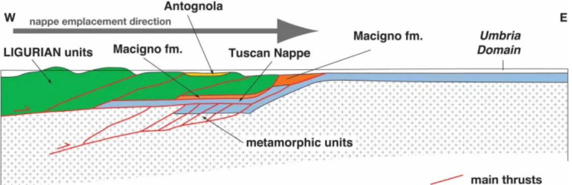
Convergence of the Brianc¸onnais microplate with the Apulia continental margin (Figure 1b, Figure 4) led first to oceanic subduction and related HP metamorphism, then during the Late Oli-gocene-Early Miocene a top-eastward tectonic transport and nappe emplacement, with: (a) defor-mation and emplacement of the ocean-derived Ligurian and Sub-ligurian units onto the Tuscan Domain; (b) emplacement of the more internal part of the Tuscan Domain (Tuscan Nappe) onto the external Tuscan Domain, which underwent greenschists facies metamorphism and iso-clinal folding (Carmignani & Kligfield, 1990).
The end of the convergence between the European and the Apulia continental margins caused the end of regional scale compressional events in the Northern Apennines. Starting from the Early Miocene (Burdigalian), due to slab retreat, the Apennine compressional front migrated eastward, so the tectonic regime progressively changed from compressional to extensional: the earlier Apennine orogenic wedge was therefore affected by widespread exhumation and extensional tec-tonics, and Neogene rift basins formed (Carmignani et al., 1995;Jolivet et al., 1998). Extension was also accompanied by widespread Late Miocene-Quaternary magmatism deriving from mixing of crustal and mantle sources.
3. The map legend
The map (see Main Map) reports metamorphic, sedimentary and magmatic units cropping out in Tuscany, grouped in palaeogeographic domains and in the main tectonic units. They are illus-trated here, starting from the structurally deepest and outermost units, for each palaeogeographic domain. The relative position of each tectonic unit is schematically illustrated in Figure 4.
Figure 4. Schematic cross section of the Northern Apennines in the Aquitanian time.
(1) Umbro-Marchean Domain: The units of this domain are the outermost of the orogenic wedge, and crop out extensively in the Central Apennines, outside of the map area. They lie below the Tuscan units, are less deformed and non-metamorphic; in the Tuscany area they consist mainly of siliciclastic turbidites and hemipelagic marls, spanning from late Burdigalian to early Messinian.
(2) Tuscan Domain: This domain represents the continental margin of the Apulia micro-plate. The respective tectonic units are both metamorphic and non-metamorphic. (a) Cervarola Unit: An Apulia-derived unit belonging to the Tuscan Domain,
consist-ing of siliciclastic turbidite and hemipelagic deposits, deposited durconsist-ing shortenconsist-ing of the Tertiary orogenic wedge. Its age is Chattian to Langhian.
(b) Tuscan Metamorphic Unit: Tectonic unit derived from severe deformation and metamorphism of part of the Apulia microplate. It is exposed in core complexes and small outcrops in northern and southern Tuscany. They consist of an Hercynian basement (Cambrian? to Devonian), a meta-siliciclastic post-Hercynian succession (late Visean-Permian), a meta-siliciclastic-carbonate Group (middle-late Triassic) and an upper carbonate-siliciclastic succession (late Triassic -? earliest Miocene). (c) Tuscan Nappe: Tectonic unit derived from the Apulia microplate. It is non-or only
slightly metamorphosed; internal thrusting and large-scale folds are only locally developed. The age of its deposits (dolostones, limestones, shales and turbiditic sand-stones) span from the late Triassic to the earliest Miocene.
(d) Pseudoverrucano Unit: A tectonic unit cropping out in southwestern Tuscany only, whose original paleogeographic domain, internal stratigraphy and evolution is still a matter of debate. We favor the interpretation that it originated from the innermost portion of the Tuscan Domain. It is composed of a great variety of lithologies, Trias-sic to Eocene in age.
(3) Subligurian Domain: It represents a transitional domain, between the continental Apulia microplate and the oceanic Ligurian Basin.
(a) Canetolo, Aveto, Coli-Marra Units: These units crop out mainly in northern Tuscany, even if scattered outcrops also occur in the southern part of the Region. They consist of shales, limestones and volcanic-bearing turbidite sandstones and conglomerates, Paleocene to Oligocene in age.
(4) Ligurian Domain: The Ligurian Domain is referred to the Ligurian-Piedmont Oceanic Basin and it is subdivided in internal and external subdomains, the latter close to the Subligurian Domain.
(a) Morello, Santa Fiora, Cassio Units: Derived from the External Ligurian Domain, and composed of ophiolitic breccias, pelagic limestones and shales, turbidite calcar-enites, marlstones and marly limestones, Cretaceous to Middle Eocene in age. (b) Helmintoides flysch, Ottone, Caio Units: Derived from the External Ligurian
Domain, they consist mainly of classical Helmintoides calcareous flysch deposits, containing ophiolitic breccias and huge ophiolitic olistostromes. These deposits date to the Cretaceous-Middle Eocene interval.
(c) Gottero, Leo, Monghidoro Units: Derived from the Internal Ligurian Domain, con-taining ophiolitic terms of oceanic crust, as serpentinites, gabbros and basalts, and the respective sedimentary cover, as ophiolitic breccias, cherts, limestones, shales and turbiditic siliciclastic sandstones. The age of the whole successions spans from the middle Jurassic to the Paleocene.
(5) Units affected by high-pressure metamorphism: Rocks affected by HP metamorphism, deformed during Tertiary convergence and subduction, before collisional phases of the Apennine orogen, now exposed in small outcrops in the Tuscan Archipelago and in
Southern Tuscany. The paleogeographic origin for these rocks is difficult to identify, but ocean-derived rocks (cherts, ophiolites, etc.) are present, together with rocks showing Tuscan affinity (marbles, dolomites, etc.). The former are derived from deformation of the Ligurian-Piedmont oceanic crust at great depths, whereas the latter are derived from the continental margin of the Apulia microplate.
(6) Apenninic Epiligurian Succession: Sedimentary succession that non-conformably covers only the Ligurian Units. It crops out only in the easternmost part of the area and deposited within thrust-top basins. It translated toward the North-East during Tertiary deformation together with allochthonous tectonic units. The deposits are mainly limestones, breccia and sandstones of a shallow marine environment of Oligocene to late Serravallian age. (7) Early-Middle Miocene Marine Deposits: Shallow-marine sedimentary rocks lying
unconformably above the orogenic nappe stack with scattered outcropping in western and southern Tuscany. Their geodynamic significance is still debated. In the literature they are considered as ‘epiligurian’ collisional (Martini, Cascella, & Rau,1995) or alter-natively as the earliest post-collisional deposits settled in extensional basins (Brogi & Liotta,2008; Cornamusini et al.,2011). Their age is middle Burdigalian-early Tortonian. The following deposits and successions are referred to the so-called ‘post-collisional Neoautochtho-nous phase’ (Bossio et al.,1998), relative to the unconformable sedimentation on the orogenic wedge. The deposits are settled in extensional basins related to the opening of the North Tyrrhenian basin.
(8) Early Turolian Lacustrine Deposits: They consist of continental conglomerates, sand-stones, siltsand-stones, clays and marls containing Ligurian olistostromes, referable to the first phases of postcollisional sedimentation (late Tortonian-Early Messinian).
(9) Pre-Evaporitic Messinian Marine Deposits: Clays, sandstones, conglomerates and bioclastic limestones, referable to a lagoonal-shallow marine environment (early Messinian).
(10) Evaporitic and Post-Evaporitic Messinian Lacustrine and Lagoonal Deposits: They consist of conglomerates, sandstones, clays, breccias, limestones and gypsum, sedimen-ted in a lacustrine to lagoonal environment. These deposits mark the Messinian Mediter-ranean evaporitic phase and the so-called ‘Lac-Mer’ phase, characterizing the late Messinian.
(11) Pliocene-Pleistocene Marine Deposits: These deposits mark the Pliocene-Pleistocene transgressive-regressive cycles, formed by shallow marine fossiliferous clays, sand-stones, conglomerates and bioclastic limestones. They infill typical graben-type basins. (12) Neogene and Quaternary Magmatic Rocks: Intrusive and effusive volcanic rocks, outcropping mostly in the Tuscan Archipelago and in Southern Tuscany (Latera-Bolsena volcanic complex). Contact metamorphism effects are not reported. These
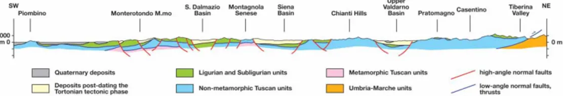
Figure 5. Geological cross section across Tuscany. See trace location in the Tectonic Map at the bottom of the Geological Map (see Main Map).
rocks are related with the opening and spreading of the Northern Tyrrhenian Sea backarc basin, during the late Miocene to Pleistocene time interval.
(13) Pliocene-Quaternary Continental and Coastal Deposits: Deposits of the Villafran-chian basins, travertines and recent deposits of the main alluvial and coastal plains. The most representative lithologies are conglomerates, sands, silts, clays, limestones and travertines. These deposits comprise also the infrequent Ruscinian continental deposits, locally separating the Pliocene marine deposits into two cycles.
The map legend (see Main Map) is simplified with respect to the 1:10,000 geological map legend and we introduced the following simplifications: all the lithostratigraphic units of the Umbro-Marchean Domain are grouped together as they have limited extension in Tuscany; all the Paleo-zoic metamorphic formations are grouped together; in the Tuscan Domain all formations of the Triassic carbonate succession are grouped together, in the Tuscan Domain all the (hemi)-pelagic pre-flysch formations are grouped together. To sum up, we grouped together lithostrati-graphic units that show stratilithostrati-graphic similarity and deposited in the same stratilithostrati-graphic and geo-dynamic setting.
4. Conclusions
This map (see Main Map) shows the main stratigraphic and tectonic features of Tuscany Region, Italy. At the map scale the main extensional Neogene basins are highlighted, as the core com-plexes where greenschist facies metamorphic rocks outcrop. The stack of tectonic units of the Northern Apennines orogen are also visible. Although some large-scale maps of the Italian North-ern Apennines have been published (Boccaletti & Coli, 1982;Cerrina Feroni, Ottria, Martinelli, & Martelli, 2002;Giannini & Lazzarotto, 1975), the current map is derived from new detailed field work at a 1:10,000 scale carried out for the entire Region. The many new details, and the effort to produce a modern geological legend and a map valid for the entire Region is of significance and importance for the whole Central Mediterranean area.
Software
The map was produced in several steps. First all the 1:10,000 maps were assembled in GIS environment using ESRI ArcMap. This allowed simplification of the geological legends, corre-lation between lithostratigraphic units, grouping of formations. Final editing and PDF production was made using Adobe Illustrator CS3.
Acknowledgements
We acknowledge all coordinators, geologists and administrative personnel who made the 2002 – 2007 Project of geological Mapping founded by the Tuscany Region possible. All their names are listed at the bottom right of the Geological Map. The realization of the project that led to complete an unique geological legend and new compilation of geological maps at 1:10,000 scale was possible, thanks to the work carried out at the Center for Geotechnologies of the University of Siena by: L. Giannetti, A. Ciulli, P.L. Fantozzi, M.F. Bastone, T. Bigio, F. Bonciani, F.N. Brogna, I. Callegari, M. Capitani, M.J.P. Chaves, E. Cocca, G. D’Amato Avanzi, I.N. Frau, Y. Galanti, F. Gamberi, A. Gatta, M. G. Giagu, B. Graziosi, D. Graziosi, L. Grazzini, E. Guastaldi, L. Innocenti, G. Lavorini, G. Liali, A. Lucchese, F. Manetti, N. Marsico, S. Mancini, G. Massa, J. Mazzi, D. Morini, F. Ortolano, E. Pasqua, M. Perna, C. Pieroni, A. Puccinelli, F. Pugnaghi, A. Rindinella, G. Verdiani. Special thanks to M. Zazzeri of ‘Litografia Artistica Cartografica’, Florence, for map corrections and final design in Adobe Illustratorw
. We thank the journal referees for useful comments and suggestions and the editor M.J. Smith for the editorial management.
References
Abbate, E., & Bruni, P. (1987). Modino-Cervarola o Modino e Cervarola? Torbiditi oligo-mioceniche ed evoluzione del margine nord-appenninico. Memorie della Societa` Geologica Italiana, 39, 19 – 33. Aldinucci, M., Gandin, A., & Sandrelli, F. (2008). The Mesozoic continental rifting in the Mediterranean
area: Insights from the Verrucano tectofacies of southern Tuscany (Northern Apennines, Italy). International Journal of Earth Sciences, 97, 1247 – 1269.
Argnani, A. (2009). Plate tectonics and the boundary between Alps and Apennines. Italian Journal of Geosciences, 128(2), 317 – 330.
Baldetti, A., Cornamusini, G., & Conti, P. (2011). Structural and stratigraphic setting of the “Pseudoverrucano” in the Montebrandoli area, southern Tuscany. Rendiconti online della Societa` Geologica Italiana, 15, 1 – 5.
Bernoulli, D. (2001). Mesozoic-tertiary carbonate platforms, slopes and basins of the external Apennines and sicily. In G. B. Vai & I. P. Martini (Eds.), Anatomy of an orogen: The Apennines and adjacent mediter-ranean basins (pp. 307 – 326). Dordrecht: Kluwer Academic Publishers.
Boccaletti, M., & Coli, M. (1982). Carta Strutturale dell’Appennino Settentrionale, 1:250.000. Pubblicazione n. 429 C.N.R. -Progetto Finalizzato Geodinamica, Sottoprogetto 5 -Modello Strutturale. SELCA, Firenze.
Boccaletti, M., Gianelli, G., & Sani, F. (1997). Tectonic regime, granite emplacement and crustal structure in the inner zone of the Northern Apennines (Tuscany, Italy). Tectonophysics, 270, 127 – 144.
Bonciani, F., Callegari, I., Conti, P., Cornamusini, G., & Carmignani, L. (2005). Neogene postcollisional evolution of the internal Northern Apennines: Insights from the upper Fiora and Albegna valleys (Mt. Amiata geothermal area, southern Tuscany). Bollettino della Societa` Geologica Italiana, Volume Speciale, 3, 103 – 118.
Bortolotti, V., Principi, G., & Treves, B. (2001). Ophiolites, ligurides and the tectonic evolution from spread-ing to convergence of a Mesozoic Western Tethys segment. In G. B. Vai & I. P. Martini (Eds.), Anatomy of an orogen: The Apennines and adjacent mediterranean basins (pp. 151 – 164). Dordrecht: Kluwer Academic Publishers.
Bossio, A., Costantini, A., Foresi, L., Lazzarotto, A., Mazzanti, R., Mazzei, R., . . . Terzuoli, A. (1998). Neogene-Quaternary sedimentary evolution in the western side of the Northern Apennines (Italy). Memorie della Societa` Geologica Italiana, 52, 513 – 525.
Brogi, A., & Liotta, D. (2008). Highly extended terrains, lateral segmentation of the substratum, and basin development: The middle-late Miocene Radicondoli Basin (inner northern Apennines, Italy). Tectonics, 27(5), TC5002.
Campetti, A., Carosi, R., Decandia, F. A., Elter, P., Lazzarotto, A., Montomoli, C., . . . Polverosi, B. (1999). Assetto ed evoluzione strutturale dei Monti dell’Uccellina (Toscana Meridionale). Bollettino della Societa` Geologica Italiana, 118, 149 – 165.
Carmignani, L., Conti, P., Cornamusini, G., & Meccheri, M. (2004). TheinternalNorthernApennines, the Northern Tyrrhenian Sea and the Sardinia-Corsica Block. In U. Crescenti, S. D’Offizi, S. Merlino, & L. Sacchi (Eds.), Geology of Italy. Special Volume of the Italian Geological Society for the IGC Florence 2004 (pp. 59 – 77). Roma: Societa` Geologica Italiana.
Carmignani, L., Decandia, F. A., Disperati, L., Fantozzi, P. L., Kligfield, R., Lazzarotto, A., . . . Meccheri, M. (2001). Inner northern Apennines. In G. B. Vai & I. P. Martini (Eds.), Anatomy of an orogen: The Apennines and adjacent mediterranean basins (pp. 197 – 214). Dordrecht: Kluwer Academic Publishers. Carmignani, L., Decandia, F. A., Disperati, L., Fantozzi, P. L., Lazzarotto, A., Liotta, D., & Oggiano, G. (1995). Relationship between the Tertiary structural evolution of the Sardinia-Corsica-Provenc¸al Domain and the Northern Apennines. Terra Nova, 7(2), 128 – 137.
Carmignani, L., & Kligfield, R. (1990). Crustal extension in the Northern Apennines: The transition from compression to extension in the Alpi Apuane core complex. Tectonics, 9(6), 1275 – 1303.
Carmignani, L., Oggiano, G., Barca, S., Conti, P., Salvadori, I., Eltrudis, A., . . . Pasci, S. (2001). Geologia della Sardegna: Note Illustrative della Carta Geologica della Sardegna in scala 1:200.000, Memorie Descrittive della Carta Geologica d’Italia, volume 60. Roma: Servizio Geologico d’Italia, 283 pp. Cerrina Feroni, A., Ottria, G., & Ellero, A. (2004). The Northern apennine, Italy: Geological structure and
transpressive evolution. In U. Crescenti, S. D’Offizi, S. Merlino, & L. Sacchi (Eds.), Geology of Italy (pp. 14 – 32). Roma: Societa` Geologica Italiana, Special volume of the Italian Geological Society for the IGC 32 Florence-2004.
Cerrina Feroni, A., Ottria, G., Martinelli, P., & Martelli, L. (2002). Carta Geologico-Strutturale dell’Appennino Emiliano-Romagnolo. Scala 1:250.000, Regione Emilia-Romagna, C.N.R., Bologna.
Chicchi, S., & Plesi, G. (1991). Il Complesso di M. Modino-M. Cervarola nell’alto Appennino emiliano (tra il Passo del Lagastrello e il M. Cimone) e i suoi rapporti con la Falda toscana, l’Unita` di Canetolo e le Liguridi. Memorie Descrittive della Carta Geologica d’Italia, 46, 139 – 163.
Conti, P., Cornamusini, G., Uccelletti, F., & Baldetti, A. (2010). Stratigraphic and structural setting of the “Pseudoverrucano” lithofacies in southern Tuscany. Rendiconti online della Societa` Geologica Italiana, 11, 324 – 325.
Cornamusini, G., Foresi, L. M., Massa, G., Bonciani, F., Callegari, I., Da Prato, S., & Ielpi, A. (2011). The Miocene successions of the Fiora Hills: Considerations about the development of the minor basins of Southern Tuscany. Italian Journal of Geosciences, 130(3), 404 – 424.
Elter, G., Elter, P., Sturani, C., & Weidmann, M. (1966). Sur la prolungation du domaine de l’ Apennin dans le Monferrat et les Alpes et sur l’origine de la Nappe de la Simme s.l. des Pre´alpes romandes et chablai-siennes. Bulletin des Laboratoires de Ge´ologie, Mine´ralogie et du Muse´e Ge´ologique de l’Universite´ de Lausanne, 19(3), 279 – 377.
Elter, P. (1975). L’ensemble ligure. Bulletin de la Socie´te´ Ge´ologique de France, 17, 984 – 997.
Elter, P., & Pertusati, P. C. (1973). Considerazioni sul limite Alpi-Appennino e sulle relazioni con l’arco delle Alpi occidentali. Memorie della Societa` Geologica Italiana, 12, 359 – 394.
Finetti, I., Boccaletti, M., Bonini, C., Del Ben, A., Geletti, R., Pipan, M., & Sani, F. (2001). Crustal section based on CROP seismic data across the North Tyrrhenian-Northern Apennines-Adriatic Sea. Tectonophysics, 343, 135 – 163.
Gandin, A. (2012). Tectonic control on the sedimentary architecture of Early Mesozoic mixed siliciclastic-carbonate Pseudoverrucano successions (southern Tuscany, Italy). Italian Journal of Geosciences, 131(1), 77 – 94.
Giannini, E., & Lazzarotto, A. (1975). Geological Map of Tuscany. In: C. Squyres (Ed.), Tectonic evolution of the Northern Apennines. Earth Sci. Soc. Libyan Arab. Rep., Tripoli: (pp.237 – 287). Geology of Italy. Handy, M. R., Schmid, S. M., Bousquet, R., Kissling, E., & Bernoulli, D. (2010). Reconciling plate-tectonic reconstructions of Alpine Tethys with the geological-geophysical record of spreading and subduction in the Alps. Earth-Science Reviews, 102(3 – 4), 121 – 158, doi:10.1016/j.earscirev.2010.06.002.
Hoogerdujin Strating, E. (1990). The evolution of the Piemonte – Ligurian ocean. A structural study of ophiolite complexes in Liguria (NW Italy). Geologica Ultraiectina, 74, 1 – 127.
Jolivet, L., Faccenna, C., Goffe´, B., Mattei, M., Rossetti, F., Brunet, C., . . . Parra, T. (1998). Midcrustal shear zones in postorogenic extension: Example from the northern Tyrrhenian Sea. Journal of Geophysical Research, 103, 12123 – 12160.
Marroni, M., Molli, G., Montanini, A., & Tribuzio, R. (1998). The association of continental crust rocks with ophiolites in the Northern Apennines (Italy): Implications for the continent-ocean transition in the Western Tethys. Tectonophysics, 292, 43 – 66.
Marroni, M., Molli, G., Ottria, G., & Pandolfi, P. (2001). Tectono-sedimentary evolution of the External Liguride units (Northern Apennines, Italy): Insights in the pre-collisional history of a fossil ocean-con-tinent transition zone. Geodinamica Acta, 14, 307 – 320.
Martini, I., Cascella, A., & Rau, A. (1995). The Manciano Sandstone: A shoreface deposit of Miocene basin of the Northern Apennines, Italy. Sedimentary Geology, 99, 37 – 59.
Molli, G. (2008). Northern Apennine – Corsica orogenic system: An updated overview. In S. Siegesmund, B. Fugenschuh, & N. Froitzheim, (Eds), Tectonic aspects of the alpine – dinaride – carpathian system. Geological Society of London Special Publications, volume 298, pp. 413 – 442. Geological Society of London.
Montomoli, C., Carosi, R., & Pertusati, P. C. (2009). Tectonic history of the Monti dell’Uccellina range, Southern Tuscany, Italy. Bollettino della Societa` Geologica Italiana, 128, 515 – 526.
Peyberne`s, B., Durand-Delga, M., & Cugny, P. (2001). Reconstitution, en Corse, au Jurassique moyen– supe´rieur, de la marge europe´enne de l’oce´an Liguro-Pie´montais, graˆce a` des niveaux repe`res a` Praekurnubia crusei (foraminife`re). Comptes Rendus de l’Acade´mie des Sciences de Paris, 332, 499– 506. Rossetti, F., Faccenna, C., Jolivet, L., Goffe´, B., & Funiciello, R. (2002). Structural signature and exhuma-tion P – T – t paths of the blueschist units exposed in the interior of the Northern Apennine chain, tectonic implication. Bollettino della Societa` Geologica Italiana, volume speciale, 1, 829 – 842.
Rossi, P., Cocherie, A., Lahonde`re, D., & Fanning, C. (2002). La marge europe´enne de la Te´thys jurassique en Corse : datation de trondhje´mites de Balagne et indices de crouˆte continentale sous le domaine Balano-Ligure. Comptes Rendus Geosciences, 334, 313 – 322.
Sani, F., Moratti, G., & Bonini, M. (1998). The geodynamic evolution of the Northern Apennines; insights from the Neogene-Quaternary basins. Annales Tectonicae, 12(1 – 2), 145 – 161.
Stampfli, G., Borel, G., Cavazza, W., Mosar, J., & Ziegler, P. (2001). The Paleotectonic Atlas of the Peritethyan Domain, volume CD-Rom. European Geophysical Society.
Stampfli, G. M., Mosar, J., Marquer, D., Marchant, R., Baudin, T., & Borel, G. (1998). Subduction and obduction processes in the Swiss Alps. Tectonophysics, 296(1 – 2), 159 – 204.
Turco, E., Macchiavelli, C., Mazzoli, S., Schettino, A., & Pierantoni, P. P. (2012). Kinematic evolution of Alpine Corsica in the framework of Mediterranean mountain belts. Tectonophysics, 579, 193 – 206. doi:10.1016/j.tecto.2012.05.010.