NUMERO 7 - dicembre 2014 Valbona Koçi
Dottorato in Architettura e Urbanistica, Uni-versità G. d’Annunzio di Pescara-Chieti / Ita-lia; Istruttore presso l’Università di EPOKA, FAE, Dipartimento di Architettura, Tirana / Albania, email: [email protected]
DAM-LAKEFRONT PLAZA: Riqualificazione di una Diga su un
Bacino Idrico per l’Agricoltura a Kashar – Tirana/Albania
Il Dam-Lakefront Plaza a Kashar-Tirana/Albania è un progetto di ricerca che propone non solo la riconsidera-zione e consolidamento delle dighe costruite durante il Socialismo in Albania all’interno dei bacini idrici artificiali, ma prevede anche la manutenzione delle dighe stesse e riqualificazione dell’area intorno al lago promuovendo la collaborazione tra pubblico e privato. Inoltre, prevede la creazione di spazi pubblici di qualità nelle prospicenti zone suburbane. Accettando i laghi artificiali come nodi specifici di infrastrutture realizzate dall’uomo dentro il paesaggio, e di conseguenza considerando le dighe (assieme ai canali di drenaggio) come importanti elementi idrotecnici delle infrastrutture protettive in caso di alluvioni, questa ricerca intende operare all’interno di un unico tipo di infrastruttu-ra paesaggistica – gli schermi verticali, offrendo una me-diazione tra il paesaggio naturale e quello costruito.
DAM-LAKEFRONT PLAZA: Revitalization of an Agriculture
Reservoir Dam in Kashar-Tirana/Albania
The Dam-Lakefront Plaza in Kashar-Tirana/Albania is a research project that proposes not only the re-consideration and reinforcement of the artificial Reservoirs Dams built during Socialism in Albania, but envisions the maintenance of dams and revitalization of the lakeside area promoting the public-private col-laboration. In addition, it envisions the generation of qualitative and lively public spaces in sub-urban areas as well. Admitting the artificial lakes as specific no-des of man-made infrastructure in the landscape, and consequently the dams (together with the drainage channels) as important hydrotechnic elements of the flood protection infrastructure, this research intends to elaborate on one type of landscape infrastructure - the vertical screens, offering a mediation between the natu-ral and built landscape.
Parole chiave: Infrastruttura del paesaggio,
Scher-mo verticale, Diga in un bacino idrico per l’agricoltu-ra, Consolidamento della diga, Infrastruttura per la prevenzione delle alluvioni, Ex-paese socialista
Keywords: Landscape infrastructure, Vertical
scre-en, Agriculture reservoir dam, Dam reinforcement, Flood prevention infrastructure, Former Socialist country
Fitim Miftari
Studente Master & Assistente di Ricerca presso l’Università di EPOKA, FAE, Dipar-timento di Architettura, Tirana / Albania, email: [email protected]
DAM-LAKEFRONT PLAZA V. Koçi, F. Miftari
INTRODUCTION AND AIM OF THE STUDY This research describes the project of Dam Lakefront Plaza- Revitalization of an Agricul-ture Reservoir Dam in Kashar-Tirana/Alba-nia, presented in ExpoTunnel: Infrastructure& Landscape Workshop, an event organized by Department of Architecture & DICAM, Univer-sity of Bologna in October 2013. This project was developed by Fitim Miftari under the gui-dance of V.Koci & I.Nase within the framework of Arch 454-Advanced Research Project in EPOKA University, during spring term 2013. The article is constructed of mainly two sec-tions: a brief theoretical one, covering the concise definition of landscape urbanism,
emphasizing the importance of awareness in architecture education about this disci-pline aiming to include it in the professional discourse. Part two, an extended and illustra-ted one, intends to provide with a detailed ex-planation of the research and project itself. First, the bigger picture of the regional study is given (100 Lakes developed by KUL team), zooming in into Kashar project (developed by EPOKA team) and then focusing on this speci-fic project, which related to landscape, infra-structure, agriculture reservoir dams, public space and program, etc. The project unfolds as the contextual analysis is highlighted, the arguments for choosing the site and building a functional and programmatic program are
offered; and the attempt to avoid package for-mulae proposal and commodification of the public space are expressed. Finally, there is an underline of the fact that this project could be an applicable and successful model in the Albanian context, which inherits from com-munism a complex water system serving agri-culture that currently fails. This presents the most important aim of the research project. Furthermore, a discussion that echoes the po-tential of landscape urbanism to re-envision the productive landscape in Albania is trigge-red.
LANDSCAPE URBANISM – THE APPROACH [Next Page]
Figure 2 - Extract of the ‘Water-Systematic Landscape’ Map zooming in to Kashar area. Source: KUL, 100 Lakes Tirana, Albania, April 2013, Interim Re-search Report
Figure 1 - The Dam-structure in relation to the reservoir
DAM-LAKEFRONT PLAZA NUMERO 7 - dicembre 2014
V. Koçi, F. Miftari V. Koçi, F. Miftari
(TO BE) APPLIED IN ARCHITECTURE /PLAN-NING SCHOOLS
Landscape Urbanism, a term first launched by Charles Waldheim, depicts a set of approa-ches to planning, urban design and landscape in which the interaction of natural and built systems is taken as the basis for decisions about urban form. Nature (environment, na-tural history), built systems (structures, ar-rangements), urban form, as well as methods and procedures, are the key concerns of lan-dscape urbanism; thus its focus is on urban space production in the contemporary city, in relation to the natural system. The diversity and intricacy of the present-day city matters, the phenomena of continuous rapid transfor-mation of the nature and systems necessitate constructive collaboration among professio-nals and experts of different fields. Quoting Waldheim, it is possible to grasp the nature of this interdisciplinary practice:
Landscape Urbanism describes a di-sciplinary realignment currently underway, in which landscape replaces architecture as the basic building block of contemporary urbani-sm…, across a range of disciplines, landscape has become both the lens through which the contemporary city is represented & the me-dium through which it is constructed (2006, p. 14).
Praxis and theory are two spheres quite com-plementary to each other. Education in (lan-dscape) architecture and planning is what
DAM-LAKEFRONT PLAZA V. Koçi, F. Miftari
proceeds the prior actions/spheres. Suppor-ting this theory, Weller argues that landscape urbanism ‘shifts the landscape architectural project from an art (or craft) of making be-autiful landscapes to one of interdisciplinary negotiation and the seeding of strategic de-velopment processes” (Weller 2008, p.248). In relation to this very brief theoretical fra-mework on LU, one assumes that landscape urbanism is emerging as a medium through which urban form can be achieved more quali-tatively. Design strategies use landscape ide-as to organize the ultimate shape of the urban form and the territory. For over decades now, it has been obvious that landscape architects and urban designers are more capable of
in-tervening into the actual context of the con-temporary city, dealing simultaneously with the socio-cultural, environmental and ecolo-gical issues, as well as the formal ones. This estimation should affect the critical thinking in Architecture and Planning Schools, emphasi-zing further the idea that Landscape Urbanism and its principles should be the complementa-ry guidelines in education when dealing/wor-king with real issues/context. This could assu-re a generation of futuassu-re architects/planner/ landscape designers who will be able to deal with the complexity of relationship between natural and built systems.
To conclude, we could modestly affirm that the methodology used in 100 LAKES/ Albania,
1/100 LAKEside settlements: Kashar, Dam-Lakefront Plaza and in each and every single project presented within this framework of this collaborative design process, presented a multi-disciplinary and contextual approach. DAM-LAKEFRONT PLAZA PROJECT IN THE CONTEXT OF 100 LAKES/ ALBANIA & 1/100 LAKESIDE SETTLEMENTS: KASHAR
The Dam-Lakefront Plaza project, is only one fragment or sequence in a whole range of proposals presented within the framework of two mayor projects: 100 LAKES/ Albania1 and
Rethinking WaterLand- 1/100 LAKEside set-tlements in Kashar2. The idea of 100 LAKES/
DAM-LAKEFRONT PLAZA NUMERO 7 - dicembre 2014
V. Koçi, F. Miftari V. Koçi, F. Miftari
prior to the initiation of the collaboration between practices (51N4E), universities (KUL and EPOKA) and other Albanian actors such as Ministry of Agriculture, communes, local ex-perts, etc. The vision of this research project presented the consideration of Tirana-Durres, the current metropolis of Albania, on a regio-nal level in order to harness the potential of the area’s assets. The assumption empha-sized the importance of the fact that the city should anchor itself into the region’s physical territory whose generous natural landscape would provide fresh impetus to the character of the urban environment. Within this fra-mework, 100 Lakes3 built during the
commu-nist period, as assumed by the idea generators
(51N4E), could be such a stimulus.
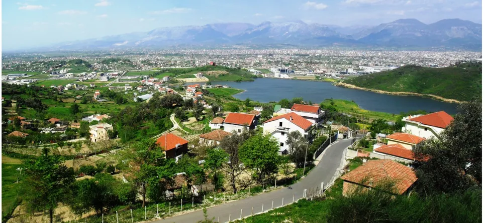
The 100 lakes provide an ecological and economic space extensive enough to ab-sorb an expanding population while harboring the capacity to develop attractive living con-ditions for inhabitants. Furthermore, rede-velopment of the 100 lakes would provide a common project where a new column of po-sitive reference can be shaped for the bene-fit of the region as a whole - a reconciliation between local inhabitants and the dificult he-ritage associated with the lakes. Crucially, 100 Lakes has the potential to act as a framework for other regional projects: notably the vision on formal-informal settlements, public tran-sport, water supply strategy, agriculture and Figure 3 - View of Purrez Lake
and area around. Picture taken by F.Miftari, April 2013
the preservation of resources. (Extract from 100 LAKES project proposal)
The 100 lakes studio attempted, at first instan-ce, to capture the specificities of the area, and take them aboard while dealing with its core questions, which were always considering a regional issue: ‘how can the (metropolitan) di-strict of Tirana- Durres manage its increasing dynamic as a whole? How can it invest in an integrative urbanism that links housing needs with economically and ecologically viable so-lutions? What meaning can the inherited and massive socialist infrastructure find today? How to develop again positive notions of col-lectivism?’ (100 LAKES/Albania)
DAM-LAKEFRONT PLAZA V. Koçi, F. Miftari
While the ‘100 LAKES’ project presented re-gional visions, ‘Rethinking Waterland’ aimed to develop bottom-up strategies for reinsta-ting the impact of man on nature, especially in developing economies where the sustaina-ble use of natural resources has least been considered. This project is a new vision for the future of an informally urbanized rural lan-dscape in the commune of Kashar, near Tira-na. The site comprises forests, orchards and agricultural land serviced by two reservoirs built during communism. This whole natural landscape is under pressure from urbaniza-tion triggered by the construcurbaniza-tion of a highway linking the capital to the main city-port of the country. The current condition is better de-scribed by a ‘parasitic symbiosis’ of the built environment (the parasite) and nature (the host). Conditioned by topography and local bu-ilding knowledge/techniques, the main impact of this parasitism has been on hydrology. Rethinking Waterland project proposes a platform for reconsidering the current inter-relationship between the built and natural en-vironments. It aims to redefine the balances in the coexistence of the built environment with infrastructure, water, nature and food produc-tion. The bottom-up approach based on nine individual projects4 stems from economic,
social and environmental sustainability tar-gets of the area. These projects include also
approaches such as the ‘neo-laissez faire’ in-troduced to control urbanization on agricultu-ral land. Implementing bottom-up strategies was considered the best response to national/ regional policies that lack environmental sen-sitivity and consideration for the local context. Project applicability will be considered with the Commune of Kashar. The design team strongly believes that this model is highly replicable to the urban landscapes along the Tirana-Durres national highway to introduce urbanization that uses natural resources su-stainably.
DEVELOPING A CONTEXTUAL ANALYSIS DAM-LAKEFRONT PLAZA: Revitalization of an Agriculture Reservoir Dam in Kashar-Tirana, is one project out of the nine students’ pro-posal presented within the 1/100 LAKEside settlements-Kashar research project. The overall research was conducted first by ma-king a spatial analysis of the water in relation to the agriculture land and urbanized area. The intention was to explore and understand the functioning of water systems and the re-lations between the rivers and streams, lakes and reservoirs, irrigation and drainage canal in (former) agriculture lands (see fig.2). Interpretative mapping, as a powerful carto-graphic tool to understand the inherent logics of territories, was made use of. The tools of research were both quantitative and qualita-tive data, such as maps, images, pictures,
re-ports of the dams and artificial lakes, etc. Primarily, due to the information package5
attained by the Ministry of Agriculture, Food and Consumer Protection on Agricultural Dams Study as part of Water Resources Ma-nagement Project, 2009, it was possible to get technical data on the water system in Kashar area and the whole region of Durres-Tirana. Moreover by developing and interpreting the new maps, it was possible to construct an understanding on the inter-relation between topography, landscape-as a collective project, water-as a systematic landscape, agriculture-as a landscape and water-dependent sector, and finally urbanization-as infrastructure dri-ven territory occupation phenomenon. Focusing on Kashar project site, an area com-prising of forests, plantations and agricultural land serviced by two reservoirs Kashar (built in 1963) and Purrez (1972), and by developing the proper contextual analysis in order to identify the Dam – area of intervention, it was possible to rich to the following conclusions: while Purrez Lake is distant to the new con-structions (fig. 3), Kashar Lake is embraced by and threatened by new buildings which over-pass the ‘buffer zone’ even (fig.3); Purrez lake is still functional. The water is used for irri-gation and the tests have proven the quality is good enough to be used as drinking water, gi-ven some water filtration plants are installed. While Kashar Lake is highly polluted due to
DAM-LAKEFRONT PLAZA NUMERO 7 - dicembre 2014
V. Koçi, F. Miftari V. Koçi, F. Miftari
Figure 4 - View of Kashar Lake and area. Picture taken by F.Miftari, April 2013
DAM-LAKEFRONT PLAZA V. Koçi, F. Miftari
port6, Kashar Lake is located some 8 km away
from Tirana; at the TWL (total water level) the reservoir has a capacity of 1.800.000m3 of water and covers a surface area of 24.5 ha. The catchment area of the reservoir is 350 ha and it was designed to irrigate some 500 ha of agriculture land. The Dam has a relati-ve height of 18 m, the length is 240 m and the crest width is 4.5 m. The upstream face slope approximates a slope of 1:2.5 while the down-stream face slope approximates an average slope of 1:2.75. The flood risk occurs at TWL. The reservoir flood is 1.5m with a pick outflow of 36m3/s that is produced by inflow reaching at max 109 m3/s. As indicated earlier, a possi-ble dam failure would eventually create a flo-many reasons including the lack of proper
se-wage system of the new settlement emerging around the lake. The dam of Purrez Reservoir is in a better condition than that of Kashar, which requires heavy maintenance. A possible failure in Purrez dam, high precipitation and eventually flood would endanger approxima-tely 500 ha of agriculture land, an area it was designed to irrigate; while a similar condition for Kashar Reservoir Dam would cause a lot more causalities in the current situation. It would not only flood some 500 ha of land, but would endanger the infrastructure& hundreds of new residential and economic activity buil-dings emerging along the highway.
Referring to the data obtained in the Dam
Re-od risk condition.
CHOOSING THE INTERVENTION SITE
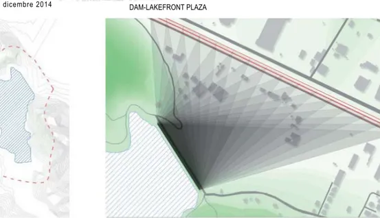
The detailed comparative analysis of both sites Purrez and Kashar Lake concluded with the decision that Kashar Reservoir Dam, the lake area as well as the Dam-front space was an appropriate site to intervene in with a design proposal. The location of Kashar Lake and the Dam, so close to the Tirana–Durres highway, yet hardly visible or perceivable as a ‘verti-cal landscape screen’ is a further reason for choosing this agriculture dam as a test-site to propose and develop the revitalization project. Moreover, referring to the dam height, the hi-ghway remains approximately 12 m below the
Figure 5 - Lake buffer-zone and Visibility of the Dam from the High-way
DAM-LAKEFRONT PLAZA NUMERO 7 - dicembre 2014
V. Koçi, F. Miftari V. Koçi, F. Miftari
highest point of the dike. In addition, two hills define the valley where the dike is constructed creating thus an attractive landscape. Yet, the buildings constructed along the highway block the view of the dike at some point.
The spatial analysis of the territory and the water-land relation, led to a project propo-sal marking some constrains, which became procreative for some ideas later on. It was important to define a “buffer zone” of 200 m off the lake shore, meaning the prevention of constructions, eventually preventing the di-scharge of grey and black waters of (informal) buildings in the lake. The reason is not only the preservation the flora/fauna of the lake and lake-shore habitat, but the improvement
of the water quality as well, assuming that the water is and will be used for various purpo-ses such as irrigation, recreation (swimming), industry (fish cultivation), etc. In addition, the definition of a buffer zone and mainly the rein-forcement of the dam would prevent possible floods in the future.
BUILDING UP A PROGRAM
FUNCTIONAL AND PROGRAMMATIC SOLUTION
The proposal to make a reinforcement of the agriculture dam of Kashar reservoir in a very architectonic way, relates with some argu-ments: first it related to the presence/intro-duction/ visibility of the Dam and Lake behind
it, from the highway (see fig.6&7). One objecti-ve of the interobjecti-vention was to indicate and em-phasize the presence of the water body, thus the reservoir behind the green vertical scre-en. Secondly it relates to the intervention, for maintenance reasons on the Dam itself, thus the prevention of dam failure due to water penetration and erosion on the downstream face slope. One of the most problematic is-sues posed to the structure of the dams bu-ilt during socialism, is the water penetration, which causes soil erosion on the downstream, eventually leading to dam failure. A technique of dike reinforcement is the injection of the concrete wall (see fig. 8). Yet, what we propose is “building on the dike slope”, making use of Figure 6 - The Dike as seen
from the highway. Picture taken by F.Miftari, October 2013
DAM-LAKEFRONT PLAZA V. Koçi, F. Miftari
Figures 7.1 & 7.2 - Frontal Elevation/Sections of the pro-posed dam structure
DAM-LAKEFRONT PLAZA NUMERO 7 - dicembre 2014
V. Koçi, F. Miftari V. Koçi, F. Miftari
the building foundation as dam reinforcement, and offering ground and space for activities accommodated within and on the structure it-self (see. fig.9). Consequently, the solution is both functional and programmatic (architec-tonic).
The idea to present such a reinforcement that would not only function structurally, but aesthetically and programmatically as well, sounded quite interesting and relevant. Such an intervention, would call for attention, peo-ple and events, fulfilling thus the ultimate goal of the project.
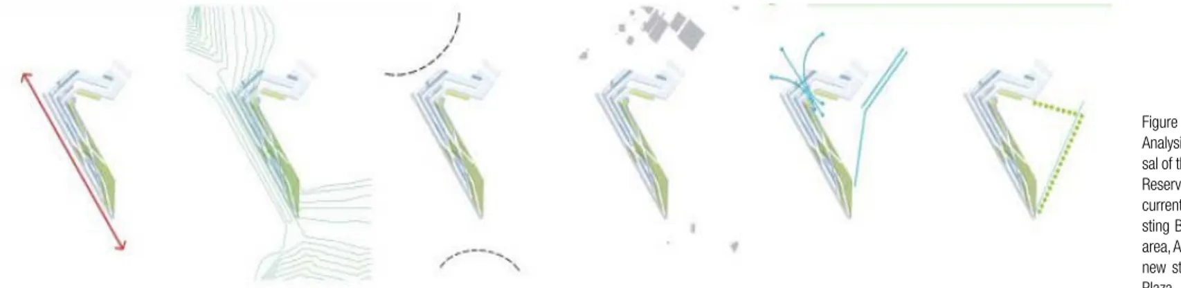
The introduction of a proper structure that would primarily act as reinforcement for the dike and then offer appropriate space to ac-commodate some relevant programs in, was the outcome of a thorough process of con-textual analysis (refer to fig. 10). The new structure had to consider the water element, thus the Reservoir surface, its water capaci-ty and possible use, as well as the Dike top, the strongest boundary and interface betwe-en water & land that emerges as a linear ele-ment with a certain length and width. This space would be part of a promenade along the lakeside. Furthermore, the Topography thus one of the most crucial features to consider while proposing the morphology of the new reinforcement structure. Though man-made, the structure has to gradually emerge with the topography and the context, being both
authentic but contextual. The current access points to the Dike and the existing buildings in the close-by area were determinant for the Approach and Access to the new structure, as well as the functions taking place in / on the structure. Ultimately, as one of the primal purposes of this project, the open space in the project had to be designed and not left-over. The dimensions, proportions and shape of the Square, the enclosure ensured by the Dam Structure and the new buildings around, cre-ate a public space that could house a series of ephemeral and programmed activities. Many events can take place on Dam-Lakefront Pla-za such as Concerts, Exhibitions, Fairs, Local Markets, Open-air cinema, Installations (see fig.11).These programs would be supported by other recreational facilities in the built struc-ture, such as swimming pool and other indoor/ outdoor sport services, shops, etc. Further-more, the downstream of the artificial lake, is turned into a recreational water pathway, as an important water feature present in the bu-ilt & natural landscape, creating a dam(med) landscape or a landscaped dam.
The analysis that lead to contextual proposal started by first checking the existing structu-res and programs sheltered in the buildings along the highway. The present activities were dominated by: hotels/motels, hospitals, pri-vate university buildings, warehouses, office buildings, shopping centers and residential
buildings. These structures are supported by mainly private initiatives and investments. What is missing in the area are Sport facili-ties, leisure centers, gathering places – public Plaza, thus programs which could be for the public but not necessarily supported by pu-blic funds. Cooperation of private investors and public structures could be tested. Thus the proposal presented a platform that serves the community and collects people from other parts of the city; a gathering place that would be multi-functional and friendly; it introduced multi-purpose spaces for different events, such as: indoor and outdoor sport activities, exhibitions, performing, lecture, shopping and exercise. What is mostly important to empha-size is the morphology and architecture of the structure proposed, which is structurally, fun-ctionally and programmatically related to the context. It offers a hierarchy of spaces: Open – the Ramp, Semi open – Multifunctional spa-ces; and the Closed Space which becomes the leisure centre (see fig. 13). In this perspective, the Ramp leads visitors to the top of the dike and lakeshore, and vice versa brings them to the Dam-front Plaza. The Semi open spa-ces, which architectonically emerge from the structural interweaving, could accommodate rental spaces for different services, tempo-rary or permanent, such as offices, classro-oms, shops. Finally, the closed space which becomes a Leisure center, would accommo-date sport activities such as swimming pool,
DAM-LAKEFRONT PLAZA V. Koçi, F. Miftari
fitness center, cafeteria/restaurant etc. The logic behind is that all spaces (open / semi-open/ closed) are owned by public institutions but managed by private – public cooperation. Within this framework, this project presents a model whose applicability could be consi-dered with the Commune of Kashar and other institutions both in the governmental and local administration level, which are involved with planning and design issues.
BUILDING UP A PROGRAM
AVOIDING COMMODIFICATION AND SPECTA-CLE-ISATION OF THE (PUBLIC) SPACE The design of public spaces that lack con-textual analysis are emerging as a package
project, which has a list of pre-defined pro-grams and sometimes schemes, producing thus a commodity7. This package project is
produced to be copied and further consumed in most geographical regions of the world. This is s a phenomenon widely spread in Al-bania as well, especially in small cities and/or sub-urban areas.
Among other places, some of the artificial la-kes built during Communism in Albania, have come to the point of being recorded into the abandoned areas’ list. They functioned as agri-culture lakes, thus for irrigation purpose, for industry (fishing and cultivation or other water species), as drinking water supply reservoirs, or recreational assets, etc. The abandonment
is a phenomena which highly relates to the change of political, economic and social sy-stem8 after the demise of communism in 1991,
and eventually to the lack of the maintenance. Yet, the very complex water system compo-sed of natural and artificial elements such as streams, rivers, lakes / reservoirs, drainage and irrigation channels etc, which we inheri-ted from the previous economic system , could become prosperous sources of capital, on the condition that these assets are properly va-luated, used and maintained. Because of the physical, social, cultural and economic featu-res inherent in them, these systems and espe-cially the sites in direct relation to the water– the irrigated lands, reservoir edges, dams etc,
[Next page]
Figure 9 - Building on the dam slope / reinforcement Figure 8 - Section-intervention on the Dam
DAM-LAKEFRONT PLAZA NUMERO 7 - dicembre 2014
DAM-LAKEFRONT PLAZA V. Koçi, F. Miftari
Figure 10 - Contextual Analysis supporting the propo-sal of the structure on the dam: Reservoir & Dam, Topography, current Access to the Dike, exi-sting Buildings in the close-by area, Approach & Access to the new structure, Dam Lakefront Plaza
could generate extensive flow of investments and spontaneous revenues.
The above-mentioned process convert the space, in our case the agriculture dam & lake; into a commodity, which needs to be deve-loped, used and ultimately exploited. It was previously mentioned that the public space projects are usually transformed into “packa-ge-formulae” planning principles introduced and implemented on different location. In some cases, these planning or design approa-ches neglect the local features, the geographi-cal, historigeographi-cal, economic and cultural assets of the region. The argument that the implemen-tations of these projects is merely an insertion of new images, which Harvey claims to “have
themselves become commodities” (1989: 287) emerges. I support the idea that presen-ted by Harvey that “many images can also be mass-marked instantaneously over space” (1989:288), and this is a similar phenomenon occurring to the public space-commodity and its created image.
Furthermore, if we have a close-look at the programs presented in the public spaces re-development projects worldwide, it is possible to see the tendency of including the spectacle and entertainment among a variety of fun-ctions. It is argued that the capital accumu-lation is facilitated through the tool of urban spectacle. This festival (fair or exhibition of every kind), and primarily the stage it would
take place on, is designed aiming the attrac-tion of the society members, local inhabitants or foreign tourists. These spectacles, events, their stages and built environment have been transformed into material simulacra9
emplo-yed in the image production industry. These simulacra“conceal almost perfectly any trace of origin of the labor process that produced them, or of the social relations implicated in their production” (Harvey: 300). Supported by the use of postmodern architecture, the style and attitude of the contemporary society, the-se asthe-semblage of social spaces have become successful in attracting the crowd and in ful-filling most of the demands of the consumer society. In a mixed-use, multi-functional inner
DAM-LAKEFRONT PLAZA NUMERO 7 - dicembre 2014
V. Koçi, F. Miftari V. Koçi, F. Miftari
[Next Page]
Figures 11.1 & 11.2 - Pro-grammatic proposal (Concerts, Exhibitions, Fairs, Local Mar-kets, Open-air cinema, Instal-lations), on the Dam-Lakefront Plaza& Dam(med) Landscape
cityscape where people find extensive pleasu-re and entertainment, the pleasu-regime of flexible accumulation is a very natural phenomenon. The very simple definition of this entire pro-cess would be the consumption of the (public) Space.
These reflections were present during the analysis developed both in the regional (Dur-res-Tirane) and local level (Kashar commune and specifically the Agriculture Dam / Reser-voir of Kashar). The conurbation between Dur-res &Tirana, the infrastructure driven urbani-zation, the uncontrolled exploitation of former agriculture land occupied by illegal construc-tions, the prevalence of individualism over collectivism in landscape and water system,
the expansion of massive shopping-malls and other selling unit that promote consumption over production, etc, are all indicators of a consumer society that would not resist the commodification and spectacle-isation of the Space, including the Public Space.
Even though ‘Rethinking Waterland: 1/100 LA-KEside settlements, Kashar/Albania’ and all individual proposals were part of an education based process, we aimed at having a syste-matic analysis and eventually relevant, unique and contextual proposal, which would avoid the commodification of the (public) space.
CONCLUSION
This research project is quite significant for the Albanian context, because its ultima-te purpose is to present a model or sample project that could be applicable, once there is good-willing and support from the local go-vernment of Kashar Commune. Conceptually this approach, or model of infrastructure re-vitalization can be applied to some 50 cases of Agriculture Reservoir Dams, out of 626 all over Albania, which necessitate high reinfor-cement intervention and maintenance, as indi-cated in the ‘Albanian Agriculture Highlights’ Report (2012: 111). Yet, a very contextual analysis and proposal should emerge from the genius loci of the place itself. As such, the
DAM-LAKEFRONT PLAZA NUMERO 7 - dicembre 2014
DAM-LAKEFRONT PLAZA V. Koçi, F. Miftari
Figure 12 - The [Dam] Struc-ture and the Hierarchy of Spa-ce: open - semi open – closed [Next pages]
Figures 13.1 & 13.2- Collage Views of the proposed Dike Structure
scussion reflects on the potential of landscape urbanism to envision, structure and re-activate the former socialist productive water-landscape in Albania, at large. This research could become the keystone for many other projects to follow.
Acknowledgements
Special thanks go to Fitim Miftari for his cre-ative work on this project. Most of the images displayed in this article are his contribution. We express gratitude to Ilir Nase, for his ex-pert guidance, and all other collaborators - actors in the bigger initiative who in/directly have contributed to this project.
DAM-LAKEFRONT PLAZA NUMERO 7 - dicembre 2014
DAM-LAKEFRONT PLAZA NUMERO 7 - dicembre 2014
V. Koçi, F. Miftari V. Koçi, F. Miftari
NOTES
[1] Spring term 2013, ‘100 Lakes/Albania’, KUL & 51N4E in collaboration with EPOKA University. This is a research thesis to obtain a Master of Science in Urbanism and Strategic Planning degree in KU Leuven, (part of the EMU Program) Department of Ar-chitecture, Urbanism and Planning, Faculty of Architec-ture. Program director: Bruno De Meulder, Supervisor André Loeckx (KU Leuven), Tutor and coordinator Sotiria Kor-naropoulou (51N4E), Co-tutor Freek Persyn, Johan Anrys (51N4E),Authors: Bogdan Ilie, Calin Lambrache, Tao Cai, Zhongkai Zhou, (EMU Students) and Wei Lu (MaUSP Student).
[2] ‘Rethinking Water-Land, 1/100 LAKEside settlements: Kashar/Albania’, Arch 454 Research project at EPOKA University, in collaboration with KUL & 51N4E, developed during January – June 2013, EPOKA University Instruc-tors: Ilir Nase, Valbona Koci. EPOKA University Students: Ajmona Hoxha, Arnen Sula, Fitim Miftari, Griselda Ramaj, Jonida Aliaj, Klodiana Millo-na, Oriela Balloshi, Romiana Cupi, Vilma Gokaj
[3] The 100 LAKES is a tittle
which eventually indicated the abundance of water cap-tured in artificial reservoirs built during Socialism (1960-1980s), and does not indicate the exact number of lakes. [4] The nine projects en-compassing ‘Rethinking Wa-terland – 1/100 LAKEside Settlements, Kashar’ rese-arch project are as follows: 1-Green Loop& Pit Stop (O.Balloshi), 2-Dam Square & Leisure Center (F.Miftari), 3-Designing AGRITECTURE (G. Ramaj), 4-Elderly Lake House (A. Sula), 5-Hill-top Winery (A.Hoxha), 6- Man+Hydro biotic symbiosis (J.Alliaj), 7-House ‘N Topo-graphy (R. Cupi), 8-ResArtist (K.Millona), 9-IN-COMmunity (V.Gokaj). More information on the individual projects can be found at: http://www. epoka.edu.al/gallery-s13- arch454-waterland-redifini-tion-228.html
[5] The information found in the Dam Reports consisted of Map of Dam Location and Catchment Area, Dam Layout Sketch, Photos, Hydrologi-cal Analysis, Indicative Flood Inundation Mapping, Indica-tive Stability and Seismic As-sessment and other technical and assessment reports. [6] Mott MacDonald and Albanian Ministry of
Agri-culture, Food and Consumer Protection, Water Resources Management Project, (2009), Agricultural Dams Study, Dam Report, Kashari Reservoir, Dam Ref: TR-5
[7] In the mid 19-th century, Marx defined commodity as: ‘an object outside us, a thing that by its properties satisfies human wants of some sort or another” (Capital and Political Economy, 1963:35).
[8] Communism, in relation to space production, is cha-racterized by a centralized state economy. Wealth redi-stributed so that everyone in
society is given equal shares of the benefits derived from labor. All means of production are controlled by the state. The means of production are commonly-owned, meaning no entity or individual owns productive property. Impor-tance is ascribed to “user-ship” over “owner“user-ship”. [9] Simulacrum, according to Harvey, is a state of near perfect replication that the difference between the ori-ginal and the copy becomes almost impossible to spot. (Harvey 1989, p. 289)
DAM-LAKEFRONT PLAZA V. Koçi, F. Miftari
BIBLIOGRAFIA Reports
(2013), 100 Lakes/Albania, KUL & 51N4E - A research thesis report to obtain a Ma-ster of Science in Urbanism and Strategic Planning. KU Leuven, (part of the EMU European Postgraduate Ma-ster in Urbanism Program) Department of Architecture, Urbanism and Planning, Fa-culty of Architecture, Program director: Bruno De Meulder,. Supervisor André Loeckx (KU Leuven), Tutor Sotiria Korna-ropoulou (51N4E), Co-tutor Freek Persyn, Johan Anrys (51N4E), Authors Bogdan Ilie, Calin Lambrache, Tao Cai, Wei Lu, Zhongkai Zhou Doko, A., Beqaj, B., and Mari-ka, Rr. (2012), Albanian Agri-culture Highlights, Q.T.T.B. Qendra e Transferimit te Teknologjise se Bujqesise, Fushe-Kruje, Albania, with the support of SNV, Publi-shing House & Printing Gent-Grapfik
Mott MacDonald & Albanian Ministry of Agriculture, Food and Consumer Protection, Water Resources Manage-ment Project, (2009), Agricul-tural Dams Study, Dam Re-port, Kashari Reservoir, Dam Ref: TR-5
Manuscripts, Contributions and Journal Articles Harvey, David (1989), The Condition of Postmodernity, Basil Blackwell, Oxford Marx, Karl, (1963), Capital: a Critique of Political Economy, Ed. Engels, Frederick, Inter-national Publishes, New York Walheim, Charles (2006). “A reference Manifesto”, in Waldheim, Charles ed., The Landscape Urbanism Reader, New York: Princeton Architec-tural Press, pp. 14 – 19 Weller, Richard (2008), “Lan-dscape (Sub)Urbanism. Theo-ry and Practice.” In Landsca-pe Journal Vol. 27 Issue 2, pp. 247 – 267


![Figure 12 - The [Dam] Struc- Struc-ture and the Hierarchy of Spa-ce: open - semi open – closed [Next pages]](https://thumb-eu.123doks.com/thumbv2/123dokorg/4552151.36864/18.1062.380.990.428.676/figure-dam-struc-struc-ture-hierarchy-closed-pages.webp)
