Studies on the Value of Cultural Heritage
201
9
19
IL CAPITALE CULTURALE
n. 19, 2019
ISSN 2039-2362 (online)
Direttore / Editor
Massimo Montella †
Co-Direttori / Co-Editors
Tommy D. Andersson, Elio Borgonovi, Rosanna Cioffi, Stefano Della Torre, Michela di Macco, Daniele Manacorda, Serge Noiret, Tonino Pencarelli, Angelo R. Pupino, Girolamo Sciullo
Coordinatore editoriale / Editorial Coordinator
Giuseppe Capriotti
Coordinatore tecnico / Managing Coordinator
Pierluigi Feliciati
Comitato editoriale / Editorial Office
Giuseppe Capriotti, Mara Cerquetti, Francesca Coltrinari, Patrizia Dragoni, Pierluigi Feliciati, Valeria Merola, Enrico Nicosia, Francesco Pirani, Mauro Saracco, Emanuela Stortoni, Federico Valacchi
Comitato scientifico - Sezione di beni culturali / Scientific Committee - Division of Cultural Heritage
Giuseppe Capriotti, Mara Cerquetti, Francesca Coltrinari, Patrizia Dragoni, Pierluigi Feliciati, Maria Teresa Gigliozzi, Susanne Adina Meyer, Massimo Montella †, Umberto Moscatelli, Sabina Pavone, Francesco Pirani, Mauro Saracco, Emanuela Stortoni, Federico Valacchi, Carmen Vitale
Comitato scientifico / Scientific Committee
Michela Addis, Tommy D. Andersson, Alberto Mario Banti, Carla Barbati, Sergio Barile, Nadia Barrella, Marisa Borraccini, Rossella Caffo, Ileana Chirassi Colombo, Rosanna Cioffi, Caterina Cirelli, Alan Clarke, Claudine Cohen, Lucia Corrain, Giuseppe Cruciani, Girolamo Cusimano, Fiorella Dallari, Stefano Della Torre, Maria del Mar Gonzalez Chacon, Maurizio De Vita, Michela di Macco, Fabio Donato, Rolando Dondarini, Andrea Emiliani †,
Emanuele Invernizzi, Lutz Klinkhammer, Federico Marazzi, Fabio Mariano, Aldo M. Morace, Raffaella Morselli, Olena Motuzenko, Giuliano Pinto, Marco Pizzo, Edouard Pommier †, Carlo Pongetti, Adriano Prosperi, Angelo R. Pupino, Bernardino Quattrociocchi, Mauro Renna, Orietta Rossi Pinelli, Roberto Sani, Girolamo Sciullo, Mislav Simunic, Simonetta Stopponi, Michele Tamma, Frank Vermeulen, Stefano Vitali
Web
http://riviste.unimc.it/index.php/cap-cult
Editore / Publisher
eum edizioni università di macerata, Centro direzionale, via Carducci 63/a – 62100 Macerata tel (39) 733 258 6081 fax (39) 733 258 6086 http://eum.unimc.it [email protected] Layout editor Roberta Salvucci
Progetto grafico / Graphics
+crocevia / studio grafico Rivista accreditata AIDEA Rivista riconosciuta CUNSTA Rivista riconosciuta SISMED Rivista indicizzata WOS Rivista indicizzata SCOPUS Inclusa in ERIH-PLUS
The management of cultural
heritage and landscape in inner
areas
edited by Mara Cerquetti, Leonardo J.
Sánchez-Mesa Martínez, Carmen Vitale
stendono a prendere il sole. Li osservo e mi sforzo di comprendere. Nessuno può capire cosa c’è sotto le cose. Non c’è tempo per fermarsi a dolersi di quello che è stato quando non c’eravamo. Andare avanti, come diceva Ma’, è l’unica direzione concessa. Altrimenti Dio ci avrebbe messo gli occhi di lato. Come i pesci1.
Quando cammino nei prati attorno al Santuario, quasi sempre solo, ripenso a nonno Venanzio che, da giovane biscino, pascolava il gregge negli stessi terreni. Mi affascina il fatto che in questo luogo la cui cifra, agli occhi di chi guarda adesso la mia scelta di vita, è la solitudine, nei secoli addietro abitassero oltre duecento persone. Ancora negli anni Cinquanta, ricorda mio nonno, erano quasi un centinaio gli abitanti di Casette di Macereto tra contadini, mezzadri, mogli, pastori e un nugolo di bambini che costringeva il maestro a salire ogni giorno da Visso per fare lezione a domicilio.
Era una comunità compatta, coordinata come lo può essere quella delle società operose degli insetti: api, formiche, tremiti, ma cosa più sorprendente che mai, una comunità niente affatto statica o chiusa2.
1 Balzano M. (2018), Resto qui, Torino: Einaudi, p. 175.
ISSN 2039-2362 (online); DOI: 10.13138/2039-2362/1926
Strategies for preventive protection
of historical settlements against
seismic events in inner areas.
Security and identity
* Gabriele Ajò, PhD student, Polytechnic of Bari, Department of Civil Engineering and Architectural Sciences, via Edoardo Orabona, 4, 70125 Bari, in consortium with “Roma Tre” University in Rome, Department of Architecture, Largo Giovanni Battista Marzi, 10, 00154 Roma, e-mail: [email protected].
Gabriele Ajò
∗Abstract
Italy is an “ancient land”. It is a territory rich in history, tradition and heritage, yet at the same time, a land very often abandoned to its own devices, damaged and lacking upkeep. There is a strong dualism between the necessity to safeguard the identifying features of its sites and the need to take action in response to people’s demands for safety in a fragile territory exposed to seismic and hydrogeological risk.
Its inner areas represent perfectly two sides of the same coin: while, on the one hand, these districts bear great potential in terms of natural and cultural resources, on the other hand, a progressive migration towards the urban areas, where the accessibility of basic goods and services is unquestionably easier, has left behind many abandoned landscapes. Many historical centers, through a lack of upkeep, have undergone a process of decay and collapse. The historical, architectural and cultural heritage of these areas is at great risk and if this tendency was not to be reversed, this slow decline will continue, accentuated by frequent seismic events and inappropriate anthropic actions.
In this context of territorial fragility, although at the same time of great historical and cultural wealth, we can outline our research objectives: the securing and enhancing of identity. Stemming the territory’s decline and the deterioration of its architectural legacy is a prime objective of the National Strategy for Inner Areas (2014-2020) and the intention of this essay is to contribute to the creation of an action protocol for the recovery and safeguard of historic construction currently endangered by the lack of active maintenance.
L’Italia è un “Paese antico”, un territorio ricco di storia, tradizione, patrimonio; allo stesso tempo un territorio, molto spesso, dell’abbandono, della mancanza di manutenzione, del dissesto. Esiste un forte dualismo tra la necessità di salvaguardare i caratteri identitari dei suoi luoghi e il bisogno di agire per soddisfare la domanda di sicurezza della popolazione in un territorio fragile, esposto al rischio sismico e idrogeologico.
Le aree interne italiane rappresentano perfettamente due facce della stessa medaglia: mentre da un lato queste posseggono grande potenziale in termini di risorse naturali e culturali, dall’altro una progressiva migrazione verso i poli urbani, dove l’accessibilità ai servizi di base è senza dubbio più facile, ha prodotto molti paesaggi dell’abbandono. Molti centri storici, a causa della mancanza di una tutela attiva, sono soggetti ad un processo di degrado e rovina. Il patrimonio storico, architettonico, culturale di queste zone è in forte pericolo e, se questa tendenza non sarà invertita, questo lento declino continuerà, accentuato ancor di più dai frequenti eventi sismici e dalle sconsiderate azioni dell’uomo.
In questo contesto di fragilità territoriale, e allo stesso tempo di grande ricchezza storico-culturale, si delineano gli obbiettivi di questa ricerca: la messa in sicurezza e il rafforzamento dell’identità. Ridurre il degrado del territorio e della sua eredità architettonica è un obiettivo primario della Strategia Nazionale per le Aree Interne (2014-2020) e l’intento di questo saggio è di contribuire in questa direzione, attraverso la creazione di un protocollo di intervento per il recupero e la salvaguardia delle costruzioni storiche di molti piccoli centri urbani messi in pericolo dalla mancanza di una manutenzione attiva.
1. Danger and seismic risk as an additional risk to Italy’s inland areas The inland areas are the subject of this international appeal whose aim is to find effective solutions to the management of the rich cultural and natural heritage of these lands, which are often unjustly thought of as marginal. Here “inland” usually refers to geographical areas in contrast to and far from “external” areas, which means those closer to the coast where in most cases there is a concentration and development of large urban centers with more favorable orographic conditions of settlement. On this subject, a large number of proposals have been advanced for what for many inland European areas is the main issue and the cause of a series of criticalities which have for some time afflicted inland settlements and territory distance. Taken together, the intermediate areas, the peripheral areas and the ultra-peripheral areas, respectively 20, 40 and 75 minutes in terms of travel time from the urban centers and the surrounding belts (often urban extensions of great metropolis)
constitute the totality of the so-called inland areas1. The first group represents
in percentage terms a far greater surface extension than the second, even if most of the European population is concentrated in coastal areas and in the big cities2. Since the end of World War II, this phenomenon has been growing
continuously and distance is the trigger: the impossibility of enjoying on-the-spot services of primary necessity, such as health, schooling and infrastructure, has accelerated migration from small settlements – often in hill or mountainous locations – to cities in the “outer” band with the consequent abandonment and poor management of inland areas; the fall in population3 and the aging of
resident population4 has led to a lack of active defense of these areas, with tragic
implications for the survival of local heritage. As a result, we see a worsening of the decay of the historical architectural assets of smaller centers and of the hydro-geological damage in historical landscapes (landslides, landslips and flooding).
This overview is a common feature to all inland European areas and those actions necessary to reduce the effects of distance must certainly be primary, a gap expressing itself in terms of services available to residents, suitable transport, more easily reachable academic institutions and tourist hospitality. The National Strategy for Inner Areas for Italy is moving in this direction.
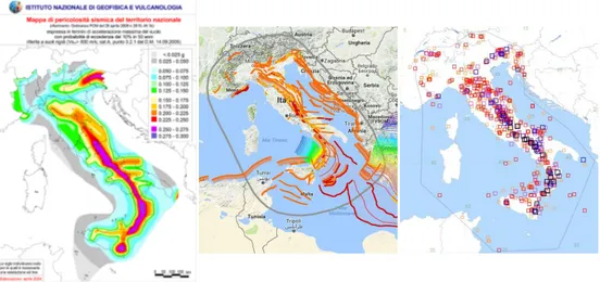
In Italy, in addition to the issues directly proportional to the inland areas-urban centers distance, we find seismic criticalities. Indeed, the national territory’s inland belt, coinciding precisely with most of the inland areas defined by the National Strategy, presents the highest seismic risk. The Map of Seismic Danger and the Database of Individual Seismogenic Sources (figs. 1a and 1b), drawn up by the INGV, locate the most important tectonic fragilities along the Apennine axis and a part of the Alpine chain5. What is more, historically, as emerges from
1 The distances in terms of travel time between urban centers and inland areas refer to the Italian land mass as defined in Barca et al. 2014 p. 25. In particular on the inland areas, see Agenzia per la Coesione Territoriale 2012; Monaco, Tortorella 2015; De Vincenti 2016; Ministero dell’Economia e delle Finanze 2017.
2 In Italy, around 75% of the population is resident in population centers and their outskirts (centers: 41%; outskirts: 32.8%), but these areas represent only 30% of the national surface area (centers: 11.1%; outskirts: 21.5%). Consequently, the inland areas constitute the bulk of the Italian land mass (intermediate areas: 30.6%; peripheries 27.5%; ultra-peripheries: 9.3%). Source: calculations by the Dipartimento per lo Sviluppo e la Coesione Economica (DPS) using Istat data 2011.
3 In local Italian Municipalities located in peripheral and ultra-peripheral areas, the average fall in population between 1971 and 2011 was equivalent respectively to -8.1% and -5.3%. Source: UVAL-UVER calculations using 1971 and 2011 Istat data. See Barca et al. 2014, p. 26.
4 The quota of the over-65 Italian population, in the same 1971-2011 band of reference, has almost doubled on a national scale, and in the inland areas, above all in the peripheral and ultra-peripheral ones, we record higher percentage increases (for example in the inland areas of Liguria and Emilia Romagna there has been an increase of over 30%). Source: calculations by UVAL-UVER using 1971 and 2011 Istat data. See Barca et al. 2014, pp. 28-29.
a consultation of the Parametric Catalogue of Italian Earthquakes6 (fig. 1c), the
main seismic events have occurred in the inland areas of the country. However, we do not need to go far back in time to realize the seismic danger of these areas: the Aquila earthquake (2009) hit the inland areas of Abruzzo (the Alto Aterno-Gran Sasso Laga), the Emilia earthquake (2012), although less seriously, hit the inland areas of the Basso Ferrarese, while the earthquake in central Italy (2016-2017) affected the inland areas of Abruzzo, Lazio, Umbria and Marche (the inland areas of the Alto Aterno-Gran Sasso Laga, Monti Reatini, Nuovo Maceratese, Ascoli Piceno, Val Nerina)7. The consequences for a great many
historical settlements in these areas have been devastating not only in terms of human lives but also of damage sustained; in some cases, such as Amatrice, to mention only one, the recovery of the village is by now compromised.
This essay attempts to focus attention on the “additional” seismic criticality of Italian inland areas. The necessity to plan sensible preventative measures for a historical building in terms of anti-seismic safeguards is of fundamental importance so as not to negate the efforts being made at national level to socio-economically enhance these areas (improvement of services, actions to favor tourism, promotion of local products, etc.). Often these actions are neglected through an underestimation of a location’s effective seismic risk and often when action is actually taken it is the result of individual intervention by farsighted property owners or by local councils “forced” to act in a situation of immediate danger. The economic component also plays a role but planning on an urban scale of the criticalities of urban blocks, according to criteria which will be explained later, can contribute to making such intervention more effective8. The
National Strategy for Inner Areas itself – we will take as an example the Dauno
Sub-Apennine area focused upon in the next paragraph9 – does not seem to
give sufficient weight to the seismic issue as it concentrates on noble actions (accessibility and enhancement of historical-cultural heritage, the return to a bond with the land and the incentivizing of local agricultural production, etc.) which, however, cannot dispense with or be disassociated from recovery work
6 See INGV 2016.
7 For detailed information on each inland area with reference to documents of the Area Strategy (Preliminaries, Outlines and Approved Strategies) see Agenzia per la Coesione Territoriale 2018.
8 Without doubt, a cultural debate and an awareness of issues of seismic danger help work go in the right direction. In this regard, note the recent 122 editions of «Ricerche di Stsoria dell’Arte», and in particular Defilippis, Menghini 2017; Zampilli 2017.
9 The documents of the Area Strategy for the Monti Dauni (Preliminary Strategy, Outline
Strategy, Summary of Area Strategy) contain no consideration of the seismicity of the area,
nor indications on preventative measures for historical buildings. See Agenzia per la Coesione Territoriale 2018a.
For details on the approval and drafting of the Monti Dauni Strategy (Comitato tecnico Aree Interne, Dossier iniziale – Regione Puglia; Comitato Nazionale Aree Interne, Rapporto di Istruttoria
per la Selezione delle Aree Interne Regione Puglia; Regione Puglia, Deliberazione Giunta Regionale n. 870, 29/4/2015, Programmazione 2014-2020. Strategia nazionale Aree Interne. Individuazione area pilota: Monti Dauni) see Agenzia per la Coesione Territoriale 2018b.
and safety measures in terms of the land and building, according to an identity-safety dualism. Here it seems that they have forgotten how a reduction over the years of active maintenance work on the territory, together with the inherent danger of these areas, have raised the vulnerability of the historical settlements exponentially. Planned protection and raising awareness in the population in terms of recovering a local seismic culture are the only solutions which will allow these historical centers to be ready for any possible earthquake.
2. The heritage of small historical settlements in the inland areas. The case
of the Dauno Sub-Apennine
So far, we have presented the main criticalities of European inland areas, with particular regard to the seismicity of inland Italy. At the same time, it is proper, however, to outline the great potential of these areas: a cultural basin of ancient origin, justifying all the greater attention to preventative actions there; not only are human lives exposed to high risk but a vast heritage of material and immaterial goods is also in danger. This should produce even greater motivation to intervene appropriately in the small historical centers scattered around tortuous landscapes, which represent the most evocative image of this heritage10.
We are suggesting a polycentric system, constituted precisely by small urban nuclei of equal size and importance, set in a prominent orographic position, and lying in opposition to the polar system of the great coastal urban centers. We are speaking of 11,311 nuclei11, whose value is represented not only by
especially precious architecture, or monumental and specialist buildings (churches, convents and palaces), but of the whole urban context itself. This involves so-called minor architecture, where the built cells in terms of succession and cohesion make up town blocks which usually adapt to the direction of the contours, turning to their own advantage unfavorable morphological conditions. The settlements blend into the surrounding landscape and into the dominant natural environment. These considerations of morphology, settlements and urban blocks not only lend a distinct identity to a place but also, as we try to show, represent significant features to bear in mind when it comes to preventative action on buildings.
The Dauno Sub-Apennine geographical area, defined as a pilot area by the Puglia Region within the National Strategy for Inner Areas, represents perfectly
10 On the subject of data and statistics concerning the heritage of Italian historical centers, we reference the recent exhibition Il Bel Paese. Un progetto per 22.621 centri storici. See Albrecht, Magrin 2017.
11 The datum refers only to those municipalities in mountainous areas as identified in Albrecht, Magrin 2017, p. 121.
the landscape-settlement system typical of Italian hill-mountain areas. We have a system of 29 centers of small-to-medium size, scattered along the Apennine chain and along its spurs of lesser height, and in strategic positions for control in former times of the main routes of passage (routes along ridge-lines, planned axes along valley floors and paths of transhumance) and for defense from enemy attack12 (fig. 2).
The area at the boundary of Basilicata, Campania and Molise, bordered to the east by the Tavoliere plain, shares with the nearby inland areas of Fortore (Molise) and Alta Iripinia (Campania) poor conditions of protection for the historical settlements and the surrounding natural environment, associated with largely unutilized but great environmental and cultural potential, as well as, once again, high seismicity (fig. 3). The fall and change in population of the Dauno Sub-Apennine have been considerable, with a drop in the number of residents of 35.4% from 1971 to 2011 and with a drastic coefficient of acceleration in the last decade (2010-2011: -9.2%). This tendency is significant if combined with two other data: the aging population (people of more than 65 years old in 2011 amounted to 24.6%, against a national percentage of 20%) and the decrease in the Agricultural Area Utilized (Superficie Agricola Utilizzata, SAU) (SAU variation 1982-2019: -9.6%; 2000-2010: -6.6%)13. These figures explain
the difficulties in managing this area’s architectural and natural heritage; we witness an ever-smaller and more elderly population unable to actively engage in the stewardship and working of the land and by the same token unable to adequately maintain historical building (in 2012 more than half of the Monti Dauni’s public or not, cultural locations were unusable). Many centers in this inland area suffer from issues of decay and damage to buildings but the most significant case is of Rione Fossi, the medieval nucleus of the historical town of Accadia (Foggia), which today appears to be totally abandoned and with almost every habitation lying in a state of ruin14. The recent attempt to rebuild/
refurbish a portion of the town with a view to revitalizing the neighborhood has been unsuccessful and even the action taken has by now itself deteriorated. The village was hit by an earthquake in the 1930s and was almost immediately abandoned by the population, even though photographs from the time bear witness that a recovery of the town was still then possible (fig. 4). The 1962 earthquake then completed the process of decay and ruin. The first event, which occurred after a long period of seismic “tranquility”, took the population unawares at a time when every aspect of “seismic culture” had been forgotten
12 For a territorial study of the Puglia area and details of routes from ancient times, see Strappa
et al. 2003, pp. 15-62.
13 Source: calculations by the Comitato Nazionale Aree Interne (Rapporto di Istruttoria per
la Selezione delle Aree Interne Regione Puglia) using 1971, 1982, 2010 and 2011 Istat data. See
Agenzia per la Coesione Territoriale 2018b.
14 On the historical center of Accadia and its history see De Bellis 2007; Palumbo 2000; Del Franco 2000.
(which is to say knowledge of those pre-modern preventative measures that had proven to be effective over the years), given the rarity of a seismic event15.
This is just one example of the importance of seismic issues affecting the area. Starting with the Parametric Catalogue of Italian Earthquakes, it has been possible to reconstruct the seismic history of the Dauno Sub-Apennine. From this, it emerges that the most important telluric episodes affected by the 29 centers had their epicenters localized outside the inland area in question, with significant but fortunately non-destructive intensity. This allowed identity-carrying features of these centers to survive, although the fairly long intervals between events have not favored the consolidation or spread of any architectural sensitivity towards earthquakes. All the sub-Apennine municipalities have undergone a seismic event between seven and nine on the Mercalli scale, and in most cases with a repeat period of more than 50 years, in other words, more than a generation, hence obstructing the conveying of a seismic culture from father to son by word of mouth16.
The need to seismically protect these historical settlements is clear: to avoid a repetition of episodes similar to Accadia, we need to take action before the event rather than later have to face post-seismic rebuilding operations in situations where a large part of the identity-carrying heritage will have been greatly undermined or actually demolished. We are dealing here with an architectural legacy of great prestige, locations awarded well-earned marks of recognition such as the Orange Flag of the Italian Touring Club and also placed on the list of Italy’s most beautiful villages17. Fortunately, we are still
in time to act despite widespread situations of maintenance not being carried out. However, without greater awareness on the part of the local population, experts and local administrations concerning knowledge and recovery of pre-modern anti-seismic techniques and defenses, and certain concepts connected to the aggregate behavior of historical building, none of this can be affected.
The Strategy for the Dauno Sub-Apennine, in its implementing of the documents of the Preliminary and Outline Strategy, dwells on the concept of the protection and enhancement of the identity of this heritage (architectural but also agricultural and woodland)18, yet without giving proper consideration
15 The earthquake preceding that of 1930 dates back 80 years earlier (1851), and the previous one again to 1732 (with an interval of 119 years between the event of the nineteenth century). We are dealing here with a fairly wide time frame.
16 On the relationship between intensity and seismic frequency on the one hand and the development of local seismic culture on the other, see Tonna, Chesi 2015; Ferrigni 2005a, pp. 206-209 and 302-306.
17 The historical centres of Alberona, Bovino, Orsara di Puglia, Pietramontecorvino, Rocchetta S. Antonio, Sant’Agata di Puglia and Troia have been awarded the Touring Club Orange Flag, a mark of tourist and environmental quality for small hinterland villages, while those of Alberona, Bovino, Pietramontecorvino and Roseto Valfortore have been recognized as being among the most beautiful villages of Italy in terms of the historical, artistic and architectural qualities they present.
to issues of security (anti-seismic prevention and limiting hydro-geological instability). Much is made of strengthening identifying features, material and otherwise, of the area and of how these can become the basis for the development of production and tourist activities linked to the local territory; concepts of tourism connected to food and wine produced locally are stressed, of traditional culture and handicrafts, and workshops involving the spreading of knowledge by local skilled workers. We also have mention of a local museum network and tourism on the part of local people, all linked to the enjoyment of architectural treasures, as well as agricultural activity based on the rediscovery of localized production. However, at least in the case in Puglia, there is no reference to the mitigation of elevated seismic risk19 or to the bolstering of
safety measures. Only within the document of a general nature entitled Strategia
Nazionale per le Aree Interne, Schema risultati attesi, Indicatori di Risultato e Azioni (National Strategy for Inner Areas, Outline of Expected Results, Result Indicators and Actions) at point [AP] RA 5.3 (code 4.4. section 4 – active
protection of the territory and local communities) do we find listed, among the objectives which an area strategy must set itself, a reduction of seismic risk through an increase of the resilience of settlements to earthquake. The ability to carry such action out must be checked annually by the Protezione Civile (Civil Defence Organisation) according to the parameter «Number of municipality areas by class of mitigation of seismic risk expressed as a percentage of the total number of municipality areas»20. However, there is no sign of any practical
application on the ground.
In conclusion and as a personal view, the Strategy for the Sub-Apennine needs to take a step backwards and place safety measures for historical buildings before or at least on the same footing as the plan for tourist development and the regeneration of the local economy and production. Action on the existing historical-architectural and natural heritage should be considered as much a priority as action, well argued in the Strategy, to reactivate primary services now deficient in the area such as health, education and transport.
compared to the national average of 42.6%; the wooded area of Puglia ran to 190,000 hectares in 2005 and is mostly concentrated in the Sub-Apennine Dauno (52% of this area is in Foggia province). Source: calculations by the Comitato Nazionale Aree Interne (Rapporto di Istruttoria
per la Selezione delle Aree Interne Regione Puglia) using 2005 and 2010 ISTAT data, see Agenzia
per la Coesione Territoriale 2018b; Brunori, Ragno 2005.
19 All 29 Sub-Apennine Dauno centers belong to the highest categories of seismic danger, 1 and 2. In particular, Accadia, Anzano di Puglia, Ascoli Satriano, Bovino, Candela, Deliceto, Monteleone di Puglia, Panni, Rocchetta S. Antonio and Sant’Agata di Puglia, fall within the most dangerous category. Although this categorization has been superseded by the NTC 2008, it remains useful in framing the area’s seismicity. Source: Dipartimento Protezione Civile, Classificazione sismica 2015
per comune.
3. Discussion of settlement blocks and morphology in relation to seism and
recovery of local seismic culture
Most historical centers belonging to the Apennine hinterland present themselves as a set of building units arranged in blocks, laid out according to the run of the terrain21. Taken together, they are often themselves a source of
beauty and typify the area, and in the Dauno Sub-Apennine the uniqueness of each historical center grows out of this relationship between built block and morphology: Sant’Agata di Puglia is designed as a block of building units with following the particular shape of the contour lines, which are alternately convex and concave; Candela stretches over a slope with convex frontages on the valley side (fig. 5); Troia is perfectly suited to a long, narrow ridge; Monteleone di Puglia, set in a wide upland plain, contains blocks set perpendicular to the lie of the land; and so on.
The structural continuity of the buildings is a result of a slow, typological process of successive blocks adapting to the terrain and modified through time (with amalgamation and division), although in very many cases the efficacy in terms of seismic stress is not considered22. Below we will outline a number of
arguments in favor of raising awareness of this “urban” and global ability to resist seisms and consider, at the scale of built-up areas, recovery of effective anti-seismic solutions involving the most critical points given by the morphological layout. The legal framework underpinning these analyses is composed of the
Norme Tecniche di Attuazione 200823 (Technical Laws on Implementation
2008) and the Circolare applicativa n. 617/2009 (Application Memorandum),
where it is stipulated that knowledge of the aggregate buildings must lie at the heart of any action on what is historically extant and that this action must take into account a structural analysis of interaction with neighboring units:
An aggregation of buildings is constituted by a sum of parts which are the result of a complex and not unitary origin, due to multiple factors (the building sequence, change in materials, different demands, revolving owners, etc.). In analyzing a building which is part of an urban aggregate, it is, therefore, necessary to take into account the possible interactions deriving
21 Among the studies on the recovery the beauty of small local centers of the Apennines, we note two didactic experiences in the inland areas of Central Italy in: Orfeo 2012; Stabile et al. 2009.
22 Among the studies dealing with subject of urban aggregates in centers of ancient formation – in contrast to the modern city layout with isolated units – and which investigate formation and difficult issues, as well as benefits deriving from structural cohesion, we cite: Cangi 2007; Carocci 2005; Pugliano 2009; Zampilli 2009 and 2014. These and many other studies originate in the typological school of Gianfranco Caniggia and in research on historical structures by Antonino Giuffrè. See Caniggia 1976; Caniggia, Maffei 1979; Giuffrè 1993.
23 Recently with the Decree-Law of 17 January 2018, Aggiornamento delle «Norme tecniche per
le costruzioni», the new NTC have come into force. However, while we await the new applicatory
memorandum, we refer to the preceding Ministerial Decree of 14 January 2008, Norme tecniche
per le costruzioni, and Circolare n. 617/2009, Istruzioni per l’applicazione delle «Nuove norme tecniche per le costruzioni» di cui al D.M. 14 gennaio 2008.
from structural bonding with adjacent buildings, either with a wall in common (connected) or with one joined to it (lean against). To this end it is essential to make a preliminary identification of the structural unit (US) under consideration and highlight action on this unit deriving from adjacent structural units.
Again:
Where necessary such a preliminary analysis must take into account the whole aggregate (block) so as to identify the fundamental relative spatial connections, with a particular focus on the context and on the mechanisms of juxtaposition and overlay24.
The starting point of our discussion, in part hinted at in the list above of a number of Sub-Apennine historical centers, concerns the relationship between the orographic conditions and the layout of the settlement. In the case of a ridge line, in other words with the settlement lying almost flat, the most critical situations will be concentrated on those frontages overlooking the “precipice”, often also critical because of the allied instability of the soil25. Where the
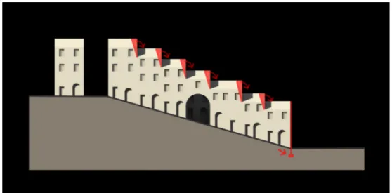
aggregate lies across the slope (slope and spur settlements, and those around a summit) the main issues will always feature on the frontage facing the valley but with obvious differences between a perpendicular layout and one parallel to the contours: in the first case, the adjacent buildings, set on terraces placed one above the other along the natural slope, constitute in their own right a resistant form – a single structural body where each cell tends to support the one above, discharging at the base the stresses transmitted by the constructions above. However, the freestanding walls erected leaning towards the slope are points of weakness as they are subject to collapse when out of plane (fig. 6). In the second case, the problems involve the lower frontage of greater height with respect to the one facing inwards, increasing the risk that the façade might collapse and/or of a shift of the base of the foundation (fig. 7). This is basic reasoning but one that allows us already to identify very quickly the frontages at risk.
We shall introduce to this interpretation some remarks on the geometry of a block and in particular on those very valley-facing frontages identified as the most exposed to seismic action. We distinguish frontages with a concave run and those which are convex26. Starting from an observation of damage to
a number of single buildings with curvilinear frontages (for example certain churches), it has been seen that in the case of down-facing concavity, this shape offers greater resistance capability27. With reference to the mechanics of arches
24 See Circolare n. 617/2009, C8A.3, Aggregati edilizi, p. 406.
25 For details on the relationship between geological conditions and issues of “architectural” instability in historical centers, see Gisotti 2011; Martinelli et al. 2005; Pergolani, Boscherini 2000.
26 With reference to such considerations, on an anti-seismic note, concerning the shape of the block and its positioning in the settlement with regard to the contour lines, see Cangi 2017; Ciaburri 2017, pp. 109-146.
27 On the most common damage-causing mechanisms of masonry buildings subjected to horizontal action (seisms), see Cangi 2009 and 2011; Cangi et al. 2010.
and vaults, this same reasoning has been transferred to urban blocks: under seismic thrust, the concave-shaped units are affected by compressive forces which tend to increase cohesion among these units, as if they were keystones in an arch, resulting in a stabilizing effect. A blocking effect is spontaneously generated, one able to oppose the horizontal stresses. In the case of a convex form aiming down, the seismic thrust towards the slope produces the opposite effect – the formation of a tight arch, as a resistant mechanism, subjects the aggregate to traction stresses which walled buildings are little able to withstand. These forces tend to detach the cells and weaken the consistency of masonry facing, with the consequent ejection of brickwork (fig. 8).
To a different urban fabric morphology, there corresponds, therefore, different resistance to seism. This global analysis is functional to the definition of those intervention criteria on the urban scale able to contribute to a reduction in the vulnerability of a historical settlement. We have seen that in most cases the weakest frontages are those facing down the valley and it is well-known that for reasons of frequency, and when compared with former seismic episodes, the most dangerous collapse mechanisms are those which tip out of plane. These cause the greatest number of victims and hinder primary rescue by blocking roads with rubble. Intervention is necessary to prevent such situations through action compatible with the historical evolution of a block and with the aim of recovering the Local Seismic Culture, in other words, «the sum of planning criteria and earthquake-resistant technologies, together with appropriate behavior deriving from these»28, which have developed over time
in the seismic area. In the Puglia area of the Sub-Apennine, this culture is slowly disappearing, or has already vanished, as in the case of Accadia, abandoned after the earthquake of 1930. The cause can be attributed to the time span for a successive earthquake greater than 50-70 years, meaning the span of a generation; this hinders the passing on of defense strategies, techniques and anti-seism building wisdom as well as allowing the memory of seismic danger to fade.
Places subject to a medium/high intensity but not frequent earthquakes: memory of their effects fades as the time passes; another earthquake causes damage; the buildings must be reinforced haphazardly, by adding new structures or mending existing ones (in this case the seismic culture concerned is said to be “repair-oriented” and is revealed by anomalies recognized in the buildings)29.
Seismic shock is the result of upwards, wave and torsional actions. The first produces an increase in vertical load, absorbed effortlessly by historical masonry constructions, while the others are a source of shear actions and of those torsional events afflicting the weakest frontages. It appears therefore
28 Ferrigni 1989. 29 Ferrigni 2005a, p. 209.
fundamental that as a very first step we must recover those defense strategies which are effective against such horizontal action. There are two most common historical approaches to combat this action and the proper combination of both has proved itself to be effective in a great many historical buildings. The first is a rigid approach which takes advantage of precise elements in positions of evident weakness (for example corner masonries), such as spurs, buttresses, chains and loggia buttresses in an attempt to counteract seismic action and reinforce the aforementioned points of weakness; the second is a flexible approach making use of structures that are deformable and/or able to transmit horizontal thrusts such as connecting arches, vaulted passages and lightweight structures. The principle is no longer that of combating forces but rather assimilating them using controlled dispersion through the ground30.
4. Reduction of urban vulnerability: actions to promote cohesion between
settlement blocks
The considerations outlined above on the geometries of blocks and the relationships between block shapes and terrain orography can be translated, through the recovery of pre-modern seismic defense systems31 (fig. 9), into
practical indications for intervention within the legislation for the protection of historic centers (refurbishment planning, detailed plans, etc.). The common thread in this is to promote action to safeguard and integrate urban structural cohesion.
To begin, we must determine the weakest frontages by way of a global reading of the neighborhood and apply the “rules of urban conduct” described above. Without neglecting, however, the importance of a critical survey taking into consideration building features and discontinuity (ambitus), it is possible to produce an analysis of the seismic resistance of any urban fabric. We can distinguish two categories of intervention, which usually correspond respectively to the rigidity principle and the flexibility principle:
– actions involving a single block (aggregation). This is work which is limited to opposing forces at the weakest points (spurs, buttresses and chaining of nodal points) and which hinder out-of-plane collapse mechanisms; – actions involving a number of blocks (more than one aggregation
of buildings). This work is more interesting because it tends to take advantage of seismic thrusts as it attempts to share the loads between as
30 In particular, for details on the two types of preventative seismic approach, see Ferrigni 2005a, pp. 199-205.
31 On the recovery of pre-modern anti-seismic defence systems and on indications for action to combat the most dangerous damage-causing mechanisms, see Cangi 2012 and 2014; Cangi et al. 2010; Ciaburri 2017, pp. 147-190; Ferrigni 2005a, pp. 215-239.
many cells and blocks as possible, so dissipating the intensity. The work is typically carried out by building opposing arches, porticos, covered and vaulted passages, and galleries, which connect adjacent blocks (at the same height) or facing (at different contour levels).
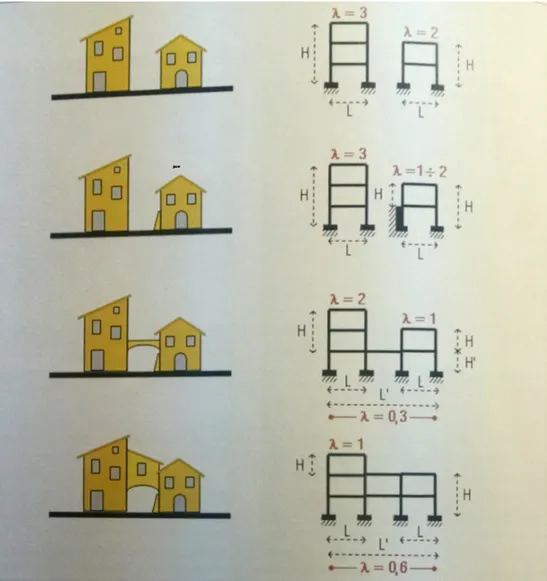
The second type of anti-seismic planning, with reference to a seismic-resistant classification of historical centers divided into four categories suggested by Ferruccio Ferrigni (fig. 10), appears also to be more effective in terms of resistance and resilience (the ability to adapt to unforeseen situations): taking global slenderness, in other words the relationship of the free height of the building to its ground width (or at the level of concatenation), as the parameter for urban seismic resistance, it is clear that the most “fragile” urban masonry block is the one comprising for the most part free-standing, unconnected buildings (elevated slenderness). On the other hand, the most seismic-resistant (low slenderness) block includes the presence of repeated adjoining arches and added vaulted volumes. The first type of work, with buttresses and spurs, belongs, however, to an inferior seismic-resistant category, featuring degrees of slenderness which are intermediate with respect to the two cases described above32.
Many regulations of the past but also much legislation currently in force seem to have forgotten the efficacy of these historically consolidated preventative measures handed down to us through the generations, in that they forbid their use or transform them into elements with a merely decorative function: arches, vaults and “pushing” structures are therefore often banned with no understanding of their anti-seismic potential. Structural separation work using separating joints are favored over traditional elements (such as wooden flooring) which promote the distribution of thrusts within the block. The main aim of these indications is to prefer an action which strengthens the cohesion between elements in historical masonry buildings set in blocks. We refer both to local action of the first type, which increases/restores the connections between frontage masonry and load-bearing walls and between masonry and flooring, as well as to global action to promote the creation of resistance mechanisms on an urban scale, through “inter-urban” connections.
Below is outlined a possible example of anti-seismic urban legislation. In order to enhance the seismic resistance of those blocks and frontages identified (according to an urban analysis) at the planning stage and adjudged to be critical, planned extensions are allowed, together with additions of connecting elements and volumes. It must be provided that they are analogous in form, technique and effect to the seismic measures already present in the historical center area, such as reinforcements at the base of walls, chains, external stairs, and features added and connected (open galleries and porticos)
to cells (first type); and connecting arches between two buildings, vaulted and covered passages and similar (second type).
Both types of intervention must:
– be carried out with construction techniques and materials similar to those of the original buildings where they are added;
– be structurally integrated and linked to the existing buildings in correspondence with the load-bearing walls perpendicular to the frontage; – be anti-seismically effective, meaning they must promote opposition
(first type) or transmission (second type) at the moment of seismic shock, with the primary objective of avoiding the most dangerous mechanisms causing tilting out of plain.
The interventions of the first type (plan extensions and concatenations-chains) can trespass on public soil only when:
– a section of road remains free to allow people and vehicles to pass unhindered;
– there occurs no increase in the number of cells.
Interventions of the second type (volumetric connections) may be made to augment the usable area of a house and its interior comfort when:
– they satisfy the above-mentioned criteria of proven anti-seismicity and structural connection;
– they allow a road height appropriate to the movement of pedestrians and vehicles;
– they respect, with a slim margin of deviation, the height of the eaves of the two connected buildings.
The anti-seismic efficacy of any work must be proven not only by planned calculations but also by purpose-drawn diagrams showing possible collapse kinematics and proposals for initiating the opposing resistance mechanisms in accordance with the methodological indications laid out in the Plan and through comparative procedures similar to other cases already present in the historical center.
5. Conclusions
In conclusion to this essay, we can make certain summary points concerning the inland areas of Italy’s land mass and on action currently being taken. The definition of a national Italian strategy for these areas may be considered to be at an advanced stage. At a regional level the situation is also well advanced with the organization of planning protocols in the form of Preliminary Outlines,
Drafts and Strategies approved, according to their state of progress. However,
in a personal view, it would seem from what emerges from our investigation of the strategy for the Monti Dauni that greater attention needs to be paid to
historical building and to a more detailed definition of the preventative work to be carried out on the latter. Securing historical settlements and the reduction of hydro-geological risk are actions which must precede respectively any effort to incentivize tourism and enhance local land and production (the primary action of many area strategies).
This study therefore focuses on preventative work on historical building and aims not so much to provide specific operational details, which could not be fully listed in this brief treatment and in any case need to be evaluated in terms of action in context, but rather to offer a method for analyzing local areas and historical centres preparatory to adopting anti-seismic measures. This approach is based on certain founding principles for settlements and aggregates: we start with an area investigation aimed at establishing the settlement typology of the town center (slope, spur, around a summit settlements) before scaling down and analyzing the urban aggregate according to the layout criteria in terms of contouring, and the shape and geometry of the facades. Reference must be made to the perpendicularity and parallelism of a building in terms of the contours, situations of slope and flat as well as differences in the convexity, concavity and linearity of the facades. At this early stage, we can already see a close correlation between the type of settlement and the typology of building aggregates; for example, in a summit settlement, we have the prevalence of a layout parallel to the contours and a convex, downward-running trend to the facades.
A second analytical process, more specific to aggregate units in the field of construction science, highlights a second consideration: each aggregate layout (parallel and convex, perpendicular and linear, etc.) contains specific weak points, local criticalities or, in contrast, greater resistance to seismic action, for the very concepts of principle cited above (shape and orographic layout). For example, a perpendicular aggregate will be more subject to collapse of the downward-facing facades when these are not supported by adjacent valley-facing cells, while an aggregate with a downward-valley-facing concavity possesses greater resistance than a convex one, due to its shape. It is in these terms that we wish to provide local administrations, experts and professionals in the field of safety with a procedure allowing them to quickly locate, with a view to initial action planning, those building facades at risk and most in need of reinforcement work.
Following a study and evaluation of the condition of buildings, action must be based methodologically on two principles: the recovery of local seismic culture and the strengthening of both the cohesion and the associative and structural integrity of the parts within the aggregate. The objective is to oppose those primary mechanisms (collapse out of plane) most damaging for buildings and the local population, strengthening of the cohesion between parts (walling, although not that alone) of the aggregate. This partnership already occurs in some cases as a result of form (downward-facing concavity or contour
perpendicularity); in others, it needs to be supported through intervention, drawn from local seismic culture, taking in large portions of the aggregate (buttresses, counterforts, supports, chains, etc.).
By extending work on the urban scale, the objective is to involve as many aggregates as possible in resisting seism, at the most extreme of including the whole neighborhood in an anti-seismic system of universal resisting mechanisms. The general principal lies in arch mechanics. Just as in an aggregate the building units behave like the keystones of a resistant arch, so on the urban scale both the aggregates and the connections between them become the elements of an overall mechanism where thrust is transmitted from one building to another until finally discharged to earth. We see a collaboration between portions of the town achieved through the introduction, restoration and recovery of those systematic links between structural units (flying buttresses, vaulted passages) of proven efficacy over the centuries. To these techniques and defences against horizontal and torsional forces (buttresses, etc.) are added those elements able to absorb thrust and promote controlled transmission between the parts (flying buttresses, etc.).
In conclusion, guidelines will try to provide the tools to direct action towards the most vulnerable aggregates, towards the weaker facades and towards those units presenting the greatest likelihood of instability. It is to be hoped therefore that there will be a change of direction in the Area Strategies currently being drawn up and a continuation of studies in the field of “urban prevention”, by means of global seismic analysis, as the law itself also demands. With this approach the totality of the building must be examined in order to identify possible mechanisms leading to instability that seismic action could cause in each single part33, so allowing us to direct safety work to where it will be most
effective in opposing those areas of probable damage triggered by seismic action.
References / Riferimenti bibliografici
Agenzia per la Coesione Territoriale, Dipartimento per lo Sviluppo e la Coesione Economica – Ministero dello Sviluppo Economico (2012), Nuove
strategie per la programmazione 2014-2020 della politica regionale: le aree interne, Atti del seminario (Roma, December 15, 2012), <http://
www.agenziacoesione.gov.it/it/politiche_e_attivita/aree_interne/Seminario_ del_15_dicembre_2012/index.html>, 21.05.2018.
Agenzia per la Coesione Territoriale (2015), Strategia Nazionale per le Aree
Interne. Schema Risultati Attesi, Indicatori di Risultato e Azioni, <http://
www.agenziacoesione.gov.it/it/Notizie_e_documenti/news/2015/novembre/ Arint_schema_risultati_attesi.html>, 21.05.2018.
Agenzia per la Coesione Territoriale (2018a), Strategie di area, <http://www. agenziacoesione.gov.it/it/arint/#>, 21.05.2018.
Agenzia per la Coesione Territoriale (2018b), Istruttoria e documentazione
Regione Puglia, <http://www.agenziacoesione.gov.it/it/arint/Selezione_aree_
progetto/Istruttoria_e_documentazione_per_regione/Regione_Puglia/index. html>, 21.05.2018.
Albrecht B., Magrin A., edited by (2017), Il Bel paese: 1 progetto x 22.621
centri storici, exhibition catalogue (Milano, Triennale di Milano, September
27–November 26, 2017), Soveria Mannelli: Rubbettino.
Barca F., Casavola P., Lucatelli S., edited by (2014), Strategia nazionale per
le aree interne: definizione, obbiettivi, strumenti e governance, «Materiali
UVAL», n. 31, pp. 1-64.
Brunori A., Ragno D., edited by (2005), Puglia: bosco, cultura e tradizione, «Alberi e territorio», II, supplement to n. 12.
Cangi G. (2007), Analisi sismica per parti: dall’elemento costruttivo all’aggregato
edilizio, per una verifica globale significativa, in Quale sicurezza per il patrimonio architettonico?, Atti del VI convegno nazionale ARCo (Mantova,
November 30 – December 2, 2006), Roma: Nuova Argos, pp. 105-117. Cangi G. (2009), Murature tradizionali e terremoto – Analisi critica del danno
come presupposto per il recupero e la ricostruzione dell’edilizia storica danneggiata dal sisma in Abruzzo, in Restaurare dopo il terremoto, Atti del
convegno ARCo (Pescara, November 27, 2009), edited by C. Varagnoli, M. D’Anselmo, F. Armillotta.
Cangi G., Caraboni M., De Maria A. (2010), Analisi strutturale per il recupero
antisismico: calcolo dei cinematismi per edifici in muratura secondo le NTC,
Roma: DEI Tipografia del Genio Civile di Roma.
Cangi G. (2011), Lettura del comportamento meccanico delle murature storiche
autostringenti e ingranate nelle prove di taglio e di compressione diagonale,
in Le murature e il rischio sismico: sperimentazioni a confronto. Proposte
per l’Aquila, Atti della giornata di studio (L’Aquila, December 15, 2011),
edited by Comune dell’Aquila, Mibac, Camera di Commercio L’Aquila, ARCo.
Cangi G. (2012), Manuale del recupero strutturale e antisismico, Roma: DEI. Cangi G. (2014), Tecniche antisismiche nell’antichità, in Attualità delle aree
archeologiche – Esperienze e proposte, a cura di A. Centroni, M.G. Filetici,
Roma: Cangemi Editore.
Cangi G. (2017), Risposta sismica e meccanismi resistenti alla scala urbana, «Ricerche di Storia dell’Arte», n. 122, Sicurezza e identità. Architetti del
patrimonio, pp. 60-66.
Caniggia G. (1976), Strutture dello spazio antropico. Studi e note, Firenze: Uniedit.
Caniggia G., Maffei G.L. (1979), Composizione architettonica e tipologia
edilizia: 1. Lettura dell’edilizia di base, Venezia: Marsilio.
Carocci C.F. (2005), La lettura critica del costruito dei centri storici, in Rischio
sismico, territorio e centri storici, Atti del convegno nazionale (Sanremo,
July 2-3, 2004), edited by S. Lagomarsino, P. Ugolini, Milano: Franco Angeli Editore, pp. 257-262.
Ciaburri N. (2017), La forma come resistenza sismica. Una città ricostruita
dopo il terremoto del 1688, Cerreto Sannita: Tetaprint.
De Bellis C. (2007), Novecento accadiese. Aspetti di vita rurale nel borgo di
Accadia, Foggia: Comune di Accadia.
Defilippis F., Menghini A.B. (2017), Sicurezza e identità. La ricerca di modelli
insediativi per la ricostruzione post-sisma, «Ricerche di Storia dell’Arte», n.
122, Sicurezza e identità. Architetti del patrimonio, pp. 11-16.
Del Franco G.M. (2000), Accadia: vita e morte di un villaggio del Sud Italia, Francia: Les Chant des hommes.
De Vincenti C. (2016), Relazione annuale al CIPE sulla Strategia nazionale
per le Aree interne, <http://www.agenziacoesione.gov.it/opencms/export/
sites/dps/it/documentazione/Aree_interne/Presentazione/Relazione_al_ CIPE_24_01_2017_def.pdf>, 21.05.2018.
Ferrigni F., edited by (1989), San Lorenzello: alla ricerca delle anomalie che
proteggono, Grenoble: PACT; Ravello: CUEBC.
Ferrigni F. (2005a), Ancient buildings and earthquakes: reducing the vulnerability
of historical built-up environment by recovering the Local Seismic Culture: principles, methods, potentialities, Bari: Edipuglia.
Ferrigni F. (2005b), I tessuti urbani del ponente ligure: un paradigma di
cultura sismica locale?, in Rischio sismico, territorio e centri storici, Atti del
convegno nazionale (Sanremo, July 2-3, 2004), edited by S. Lagomarsino, P. Ugolini, Milano: Franco Angeli Editore, pp. 245-255.
Gisotti G. (2011), Le unità di paesaggio. Analisi geomorfologica per la
pianificazione territoriale e urbanistica, Palermo: Flaccovio Editore.
Giuffrè A. (1993), Sicurezza e conservazione dei centri storici. Il caso Ortigia, Bari: Laterza.
Istituto Nazionale di Geofisica e Vulcanologia (INGV) (2006), Mappa di
pericolosità sismica del territorio nazionale, Ordinanza P.C.M. 3519 del 28
aprile 2006, All. 1b, <http://zonesismiche.mi.ingv.it/mappa_ps_apr04/italia. html>, 21.05.2018.
Istituto Nazionale di Geofisica e Vulcanologia (INGV) (2016), CPTI15, the
2015 version of the Parametric Catalogue of Italian Earthquakes, <https://
emidius.mi.ingv.it/CPTI15-DBMI15/>, 21.05.2018.
Istituto Nazionale di Geofisica e Vulcanologia (INGV), DISS Working Group (2018), Database of Individual Seismogenic Sources (DISS), Version 3.2.1: A compilation of potential sources for earthquakes larger than M 5.5 in Italy and surrounding areas, <http://diss.rm.ingv.it/diss/>, 21.05.2018.
Martinelli A., Lemme A., Peppoloni S., Di Capua G. (2005), Vulnerabilità
sismica e danno agli edifici in muratura dei centri storici: il caso studio di Ripabottoni (CB). Un esempio di integrazione tra dati ingegneristici e geologici, in Rischio sismico, territorio e centri storici, Atti del convegno
nazionale (Sanremo, July 2-3, 2004), edited by S. Lagomarsino, P. Ugolini, Milano: Franco Angeli Editore, pp. 219-228.
Ministero dell’Economia e delle Finanze (2017), Documento di Economia e
Finanza 2017, Sezione III – Programma Nazionale di Riforma, <http://www.
agenziacoesione.gov.it/opencms/export/sites/dps/it/documentazione/Aree_ interne/Estratto_PNR_2017.pdf>, 21.05.2018.
Monaco F., Tortorella W., edited by (2015), I comuni della Strategia Nazionale
Aree Interne, in Studi e Ricerche, Fondazione Istituto per la Finanza e
l’Economia Locale (IFEL), Roma: SER Società Editrice Romana.
Orfeo C. (2012), L’architettura del territorio. I piccoli centri dell’aquilano, Roma: Aracne.
Palumbo V. (2000), Immagini di Accadia nei segni di Vincenzo Palumbo. Figure
di vita identiche nei paesi «Dauni-irpini», Napoli: Procaccini.
Pergolani F., Boscherini A., edited by (2000), La microzonazione sismica speditiva
relativa ai terremoti del 1997-98 in Umbria: le situazioni morfostratigrafiche suscettibili di amplificazione sismica locale, Terni: Tipolito Visconti.
Pugliano A. (2009), Il riconoscimento, la documentazione, il catalogo dei beni
architettonici: elementi di un costituendo thesaurus utile alla conoscenza, alla tutela, alla conservazione dell’architettura, Roma: Prospettive.
Stabile F.R., Zampilli M., Cortesi C., edited by (2009), Centri storici minori.
Progetti per il recupero della bellezza, Roma: Gangemi Editore.
Strappa G., Ieva M., Dimatteo A. (2003), La città come organismo. Lettura di
Trani alle diverse scale, Bari: M. Adda.
Tonna S., Chesi C. (2015), Implications of earthquake return periods on the
building quality, in Heritage and Technology. Mind, Knowledge, Experience,
Atti del XIII International Forum Le Vie dei Mercanti (Aversa – Capri, June 11-13, 2015), Napoli: La Scuola di Pitagora editrice, pp. 784-793.
Zampilli M. (2009), Il restauro del tessuto urbano, «Ricerche di Storia dell’Arte», n. 99, pp. 43-54.
Zampilli M. (2014), Analisi dei processi formativi dei tessuti urbani: note di
metodo, «Ricerche di Storia dell’Arte», n. 112, pp. 23-34.
Zampilli M. (2017), Come affrontare il processo di ricostruzione dei centri
storici, «Ricerche di Storia dell’Arte», n. 122, Sicurezza e identità. Architetti del patrimonio, pp. 37-50.
Appendix
Fig.1 a. Map of Seismic Danger of Italy; b. Database of Individual Seismogenic Sources (DISS); c. Parametric Catalogue of Italian Earthquakes (CPTI15) (INGV)
Fig. 2. The Inland area of the Monti Dauni and its confines: hydro-orographic reconstruction and location of the 29 historic centers (drawn up by the author)
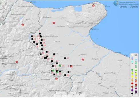
Fig. 3. Historical seismicity in the Dauno Sub-Apennine area and surroundings. The 29 municipalities are highlighted with black squares. The epicenters of earthquakes of great intensity are highlighted with a red star and those of medium intensity with a green star (drawn up by the author on INGV base)
Fig. 4. Accadia (FG). View of the village after the 1930 earthquake: although the village was severely damaged, it appears to be still standing and able to be rebuilt (photo of the Accadia Municipality)
Fig. 5. Candela (FG). Technical regional map, where we note the layout of the block parallel to the contours and with a convex advancement (SIT Puglia)
Fig. 6. A layout orthogonal to the contours: the freestanding walls are points of weakness (drawn up by the author using references in Cangi 2017)
Fig. 7. One block on sloping terrain and another on a flat surface, both parallel to the contours. In the first case it is more probable that the façade should collapse out of plane and/or shift at the base of the foundation under a seismic shock (drawn up by the author using references in Cangi 2017)
Fig. 8. a. An aggregate with a concave shape develops a resistance mechanism which forces compression stresses upon the cells; b. An aggregate with a convex shape, where the forces tends to detach the cells (drawn up by the author using references in Cangi 2017)
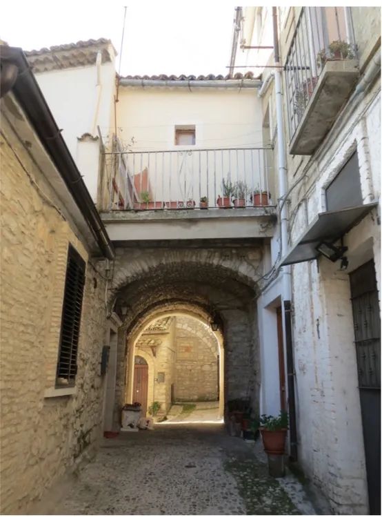
Fig. 9. Sant’Agata di Puglia (FG). View of a connecting vault between two facing blocks set on different contour levels. An effective anti-seismic measure but one which has undergone inappropriate additions (photo by the author)
Fig. 10. Classification in four categories of the seismic resistance of a historical settlement (Ferrigni 2005a)
eum edizioni università di macerata
Department of Education, Cultural Heritage and Tourism
University of Macerata
Direttore / Editor
Massimo Montella †
Co-Direttori / Co-Editors
Tommy D. Andersson, University of Gothenburg, Svezia Elio Borgonovi, Università Bocconi di Milano
Rosanna Cioffi, Seconda Università di Napoli Stefano Della Torre, Politecnico di Milano
Michela di Macco, Università di Roma “La Sapienza” Daniele Manacorda, Università degli Studi di Roma Tre Serge Noiret, European University Institute
Tonino Pencarelli, Università di Urbino "Carlo Bo"
Angelo R. Pupino, Università degli Studi di Napoli L'Orientale Girolamo Sciullo, Università di Bologna
Texts by
Gabriele Ajò, Letizia Bindi, Massimiliano Biondi, Clinton Jacob Buhler, Flaminia Cabras, Chiara Capponi,Michele Catinari, Giacomo Cavuta, Chiara Cerioni, Mara Cerquetti, Paolo Clini, Annalisa Colecchia, Federico, Lattanzio, Manuel De Luca, Sara Manali, Dante Di Matteo, Anna Rosa Melecrinis, Emanuele Frontoni, Letizia Gaeta, Maria Teresa Gigliozzi, Gianpasquale Greco, Elena Montanari, Rossella Moscarelli, CaterinaPaparello, Giulia Pappani, Michela Passini, Roberto Pierdicca,
Mariapaola Puggioni, Ramona Quattrini, Manlio Rossi-Doria,
Leonardo J. Sánchez-Mesa Martínez, Federica Maria Chiara Santagati, Andrea Ugolini, Carmen Vitale