The 2013 Lunigiana (Central Italy) earthquake: Seismic source analysis from DInSar and 1
seismological data, and geodynamic implications for the northern Apennines. A discussion 2
3
Molli G.1, Torelli L.2, Storti F.2 4
5
1. Dipartimento di Scienze della Terra, Università di Pisa, Via S. Maria, 53, 56126 Pisa, Italy 6
Via S.Maria, 53, 56126 Pisa , ++39 050 221749, [email protected] 7
2. Dipartimento di Fisica e Scienze della Terra “Macedonio Melloni”, Università degli Studi di 8
Parma, 43124 Parma, Italy 9
10
The contribution of Pezzo et al. 2014 represents one of the first published scientific papers (see 11
also Stramondo et al., 2014) on the 2013 Mw 5.1 Lunigiana (northern Italy) earthquake following 12
the early-bird seismological, geodetical as well as DInSar technical reports published during the 13
seismic sequence (http://ingvterremoti.wordpress.com/category/sequenza-in-lunigiana/). Pezzo et 14
al., use Synthetic Aperture Radar differential Interferometry (DInSar) and seismological data to 15
constrain the seismic source of the main shock of the 2013 Lunigiana sequence, namely the 2013 16
June 21 Mw 5.1 event. Moreover, as directly referred to in the title, the authors aim at discussing 17
the geodynamic implications of their analysis for the northern Apennines by taking into account the 18
tectonic structures of the area, which represent fundamental input parameters for a correct seismic 19
hazard assessment. Actually, the three-dimensional complexity of the tectonic architecture of the 20
northern Apennines in the Alpi Apuane-Lunigiana region, if not properly taken into account, can 21
cause deep uncertainty in the accurate determination of the source of the 2013 Lunigiana 22
mainshock. Given the seismic hazard of the region and its social relevance (Ferretti et al., 2005; 23
Meletti et al., 2004; Rovida et al., 2011; Mantovani et al. 2012), in the following we complement 24
and refine the geological information provided by Pezzo et al., with the purpose of helping future 25
work on the subject. 26
*Revised manuscript with no changes marked
Click here to view linked References Tectonophysics 668–669 (2016) 108–112 http://dx.doi.org/10.1016/j.tecto.2015.07.041
27
1) The inner northern Apennines struck by the 2013 June 21 Mw 5.1 earthquake and related seismic 28
sequence are characterized by four recent to active regional tectonic structures Fig.1. They include 29
the Alpi Apuane morphostructural high and three surrounding tectonic depressions: the Garfagnana 30
to the east, the Viareggio basin to the west (with its northern prolongation represented by the lower 31
Lunigiana/Val di Vara) and the upper Lunigiana to the north (Fig.1). Plio-Quaternary intramontane 32
to marine sediments record the progressive but unsteady evolution of the tectonic depressions 33
whose boundary faults controlled and/or displaced the basins’ sediments (Federici, 1978; Raggi, 34
1985; Bernini and Papani, 2002; Di Naccio et al., 2013). Actually, the exposed and buried faults 35
bounding the Alpi Apuane to the west and confining the Viareggio basin eastward show cumulative 36
post-Early Pliocene to present vertical displacement values that are amongst the highest for normal 37
fault-systems of the whole Italian peninsula (Bigot, 2010). Although Pezzo et al. quote recent 38
seismotectonic literature (DISS working Group 2010) reporting seismogenic sources only for the 39
Lunigiana and Garfagnana grabens, historic seismicity, geological, morphotectonical as well as 40
geodetical data (Federici, 1978; ITHACA, 2000; Bigot, 2010; Molli et al., 2008; Rovida et al. 2011; 41
Bennett et al., 2012; Molli, 2013; Pinelli, 2014) suggest recent to present-day tectonic activity all 42
around the Alpi Apuane high. 43
44
2) In Pezzo et al. the surface fault structure related to the seismic source of the 2013 Lunigiana 45
event is reported to be the nearly E-W striking Minucciano Fault. In fact, the Minucciano Fault 46
(ITHACA 2000, Boncio et al., 2000; Di Naccio et al., 2013 and references therein) is a NW-SE 47
trending (310°), east dipping fault zone. Moreover, a detailed analysis of this structure has led Di 48
Naccio (2009) to rule out its Holocene activity. 49
50
3) The fault system relevant to the 2013 Lunigiana earthquake is reported in recent geological 51
literature as North Apuane Transfer Fault (Brozzetti et al., 2007), as Marciaso-Tenerano Fault 52
(Scandone, 2007, where it is incorrectly reported as Marciano-Tenerano Fault) and, more recently, 53
as North Apuane Fault System (Molli, 2013; Molli et al., 2015). This fault system includes the 54
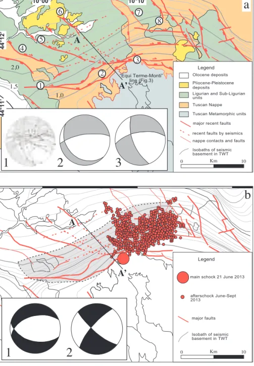
surface splays of a subsurface structure well defined (Fig. 2a,b) by contours of seismic basement 55
derived from Eni regional lines across the area (Artoni et al., 2000; Camurri et al., 2001; Argnani et 56
al., 2003). 57
The seismic basement extends northward from the outcropping areas of the metamorphic units in 58
the Alpi Apuane and deep towards north/northwest with a N60E strike turning toward NE below the 59
Garfagnana. In Fig. 2b the locations of the 2013 Lunigiana seismic sequence are reported with 60
projection of the main shock and aftershocks over the depth contours.
61
As concerns the surface splays of the North Apuane Fault (Fig. 1, Fig.2) they are striking for nearly 62
20 Km with a SW-NE trend, and include three interconnected segments: the westernmost E-W 63
trending Fosdinovo Fault, the central NE/SW trending Marciaso-Tenerano Fault and the 64
northeasternmost, nearly E-W trending, segment represented by the Aiola-Equi Terme Fault. The 65
Aiola-Equi Terme Fault shows evidence (bedrock fault scarps, triangular facets, hydrothermal 66
springs) of recent activity (ITHACA 2000; Di Naccio 2009; Molli et al., 2015) and has a primary 67
seismogenic role in the 2013 June 21 Mw 5.1 main shock. In fact, the Aiola-Equi Terme Fault (for 68
details see Molli et al., 2015) has a transcurrent component compatible with a direction of 69
maximum shortening (P axis) plunging at a low angle approximately SE-NW and a sub-horizontal 70
maximum extension (T axis) SW-NE oriented (Fig.2a). The coupled system of normal fault zones 71
and/or normal/oblique faults is associated with a sub-vertical direction of maximum shortening 72
and an approximately NS sub-horizontal direction of maximum extension (Fig.2a). As a whole, the 73
kinematic analysis suggests a dextral transtensive setting for the Aiola-Equi Terme Fault, which is 74
well compatible with the focal mechanism of the main shock reported by Pezzo et al. as well as by 75
previous INGV reports (http://ingvterremoti.wordpress.com/category/sequenza-in-lunigiana/) (Fig. 76
2b). It follows that the structure relevant for the discussion of the main shock of June 21st is not the 77
Minucciano Fault but the Aiola-Equi Terme Fault, i.e. the easternmost surface splay of the North 78
Apuane Fault. 79
80
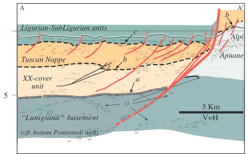
4) The line-drawing of Fig. 3, modified from Camurri et al. (2001), cross-cuts the North Apuane 81
Fault at depth and its Aiola-Equi Terme segment at the surface, allowing to better constrain the 82
seismic source of the 2013 Lunigiana EQ. The fault is well imaged down to a depth of 5 Km (c. 2 83
sec in TWT, Fig. 2b) where it separates a metamorphic footwall domain (Apuane-units in sub-84
surface) from non-metamorphic cover units of the Northern Apennines nappe stack (Ligurian, sub-85
Ligurian and Tuscan units). The dip angle of the sub-surface Equi Terme Fault appears slightly 86
steeper than reported in Pezzo et al. (c. 50° instead of 44°) and basically shows the same dip 87
modelled by Stramondo et al. (2014). A first order correlation between nappe stack units in surface 88
and subsurface between the footwall (Alpi Apuane) and hanging-wall (Lunigiana) blocks reveals an 89
along strike variation of the thrust sheet stack with an extra non-metamorphic unit (XX-cover unit) 90
underlying the reflector b in Fig.3 (basal contact of the Tuscan nappe in surface exposure), which is 91
absent in the footwall block. This major feature may be related to a setting in which the North 92
Apuane Fault reworked a previous lateral ramp and/or transfer zone of the contractional wedge and 93
an early system of low angle normal faults. This hardly fits a simplistic interpretation of the North 94
Apuane fault system as part of the transfer zone of an extensional framework formed by two major 95
low angle east-dipping extensional structures (the Lunigiana and Garfagnana Low Angle Normal 96
Fault, part of the Etrurian Fault System of Boncio et al., 2000; Basili et al., 2008; Meletti et al., 97
2008) as reported in Pezzo et al., nor does it suit the similar frame of a breached-relay ramp 98
proposed by Stramondo et al. (2014). 99
100
5) Finally, the presence of a high velocity Apuane structure (metamorphic units) juxtaposed against 101
low velocity units all around the Alpi Apuane with a complex 3D subsurface architecture, in 102
particular across the area of the 2013 Lunigiana earthquake, calls for a general reconsideration of 103
the whole seismic sequence at least in terms of depth of the events using a 3D velocity model 104
instead of a simple 2D one (Scognamiglio et al., 2009; Barani et al., 2013). Only after the 105
relocation of the main event and aftershocks it will be possible to discuss in detail the 106
seismotectonics of the 2013 Lunigiana earthquake and test the kinematic and tectonic role of the 107
North Apuane Fault. 108
109
In conclusion, as correctly underlined by Pezzo et al., the seismic source of the 2013 Lunigiana 110
earthquake was not listed among the seismogenic sources of the Italian National catalogue, 111
although clearly identified by neo-tectonics and geodetic studies (Raggi, 1985; Moretti, 1992; 112
ITHACA, 2000; Bernini and Papani, 2002; Brozzetti et al., 2007; Scandone et al., 2007; Bigot, 113
2010; Bennett et al. 2012). This suggests an overall re-evaluation of the northern Apennines’ 114
seismic potential of transversal structures and of other structures defined by field studies (e.g. 115
Benedetti et al., 2003; Bigot, 2010; Bigot et al., 2014; Pinelli, 2014), so far unrecognized because of 116
a weak or absent instrumental and/or historical seismic activity and therefore not yet included in the 117
Italian National seismic hazard evaluation. Moreover, the role and the main seismogenic sources in 118
the northern Apennines have to be better constrained by tectonic studies and the present-day 119
activity of transverse structures must be framed and understood in terms of the tectonic inheritance 120
for the inner part of the belt as well as for its external zone (Sorgi et al., 1998; Vescovi, 2005; Corti 121
et al., 2006; Cuffaro et al., 2010; Molli and Meccheri 2012). 122
123
References 124
125
Anelli L., Gorza M., Pieri M., Riva M. (1994) Subsurface well data in the northern Apennines 126
(Italy). Mem.Soc.Geol.It., 48, 461-471. 127
128
Argnani, A., Barbacini, G., Bernini, M., Camurri, F., Ghielmi, M., Papani, G., Rizzini, F., Rogledi, 129
S., Torelli, L., 2003. Gravity tectonics driven by Quaternary uplift in the northern Apennines: 130
insight from the La Spezia–Reggio Emilia geo-transect. Quaternary International 101–102, 13–26. 131
132
Artoni, A., Bernini, M., Papani, G., Vescovi, P., Zanzucchi, G., 1992. Sezione geologica schematica 133
Bonassola (SP)–Felino (PR). Studi Geologici Camerti Special Volume 1992 (2), 61–63. 134
135
Barani S., De Ferrari R., Ferretti G., Pasta M., Scafidi D., Spallarossa D., Turino C. 2013. Seismic 136
monitoring in Garfagna-Lunigiana. Geoitalia 2013. IX Forum Italiano Scienze della Terra. 137
138
Basili R., Valensise G., Vannoli P., Burrato P., Fracassi U., Mariano S., Tiberti M., Boschi E. 139
(2008). The Database of individual Seismogenic Sources (DISS), version 3: Summarizing 20 years 140
of research on Italy’s earthquakes geology. Tectonophysics, 453, 20-43. 141
142
Benedetti L., Tapponier P., Gaudemer Y., Manighetti I., Van der Woerd J. 2003. Geomorphic 143
evidence for an emergent active thrust along the edge of Po Plain: The Boni-Stradella Fault. 144
Geophysical Research 108(B5), 2238, doi:10.1029/2001JB001546. 145
146
Bennet R.A., Serpelloni E., Hreinsdóttir S., Brandon M.T., Buble G., Basic T., Casale G., Cavaliere 147
A., Anzidei M., Marjonovic M., Minelli G., Molli G. & Montanari A. 2012. Syn-convergent 148
extension observed using the RETREAT GPS network, northern Apennines, Italy. Journal of 149
Geophysical Research 117, B04408, doi:10.1029/2011JB008744. 150
Bernini M., Papani G. 2002. Distensione della fossa tettonica della Lunigiana nord-occidentale 151
(con Carta geologica alla scala 1:50.000) Boll.Soc.Geol.It. 121, 313-341. 152
Bigot A. 2010. Aléa sismique de la regione de Pise (Italie): etude morphostructural des failles 153
bordières du Bassin de Viareggio. Master Geoscience Montpellier 28 pp. 154
Bigot A., Manighetti I., Sénéchal G., Garambois S., Larrouque C., Malavieille J., Molli G., Cotte 155
N., Delor E., Palis E., Pinard H. 2014. Imagerie multi-échelles d’un système de failles décrochantes 156
potentiellement actives dans la plaine du Po. Résumés de la RST 2014, 34. 157
Boncio, P., Brozzetti, F., Lavecchia, G., 2000. Architecture and seismotectonics of a regional Low-158
Angle Normal Fault zone in Central Italy. Tectonics 19, 1038–1055. 159
160
Brozzetti F., Boncio P., Di Naccio D., De Angelis D., De Chiara B., La Starza C., Torelli L. 2007 161
Active extension and seismogenic hypothesis of the Lunigiana-Garfagnana system (northern 162
Apennines, Italy). Proceedings of the Camerino workshop “Dieci anni dopo il terremoto 163
dell’Umbria-Marche: conoscenze sulla sismogenesi italiana”, 63. 164
Camurri, F., Argnani, A., Bernini, M., Papani, G., Rogledi, S., Torelli, L., 2001. The basement of 165
the NW Apennines: interpretation of reflection seismics and geodynamic implications. Final 166
Proceedings, Geoitalia 2001, 3° Forum Italiano di Scienze della Terra (Fist), Chieti, Italy, 50–51. 167
168
Corti, G., Serena, L., Bonini, M., Sani, F., Mazzarini, F., 2006. Interaction between normal faults 169
and pre-existing thrust systems in analogue models. In: Buiter, S.J.H., Schreurs, G. (Eds.), 170
Analogue and numerical modeling of crustal-scale processes: Geol. Soc. Lond. Spec. Publ., 253, 171
65–78. 172
173
Cuffaro, M., Riguzzi, F., Scrocca, D., Antonioli, F., Carminati, E., Livani, M., Doglioni, C., 2010. 174
On the geodynamics of the northern Adriatic plate. Rendiconti Fisiche Accademia di Lincei 21 175
(Suppl. 1), S253–S279. http://dx.doi.org/10.1007/s12210- 010-0098-9. 176
177
Di Naccio, D., 2009 Morphotectonic analysis of the Lunigiana and Garfagnana grabens (Northern 178
Italy): implications for active and potentially seismogenic normal faulting. PhD thesis, Università 179
degli Studi di Chieti-Pescara, 97 pp. 180
181
Di Naccio, D., Boncio, P., Brozzetti, F., Pazzaglia, F.J., Lavecchia, G., 2013. Morphotectonic 182
analysis of the Lunigiana and Garfagnana grabens (northern Apennines, Italy): implications for 183
active normal faulting. Geomorphology 201, 293–311. 184
185
DISS Working Group, 2010. Database of Individual Seismogenic Sources (DISS), Version 3.1.1: a 186
compilation of potential sources for earthquakes larger than M 5.5 in Italy and surrounding areas. 187
http://diss.rm.ingv.it/diss/. http://dx.doi.org/10.6092/ INGV.IT-DISS3.1.1. 188
189
Federici P.R. 1978. La tettonica recente dell’Appennino; 2) Il bacino fluvio-lacustre di Pontremoli 190
(alta Val di Magra) e sue implicazioni neotettoniche. G.S.Q.P., Quaderno n. 4, 121-131. 191
192
Ferretti G., Massa M., Solarino S. 2005. An improved method for recognition od seismic families: 193
Application to the Garfagnana-Lunigiana Area, Italy. Bull. Seismol. Soc. Am., 96(5), 1903-1915. 194
195
ITHACA (2010) Catalogo delle Faglie Capaci. http://www.ispraambiente.gov.it 196
197
Mantovani E., Viti M., Babbucci D., Cenni N., Tamburelli C., Vannucchi A., Falciani F., Fianchisti 198
G., Baglione M., D’Intinosante V., Fabbroni P. 2012. Potenzialità sismica della Toscana e 199
definizione di criteri di priorità per interventi di prevenzione. Regione Toscana 141 pp. 200
201
Meletti C., Camassi R., Stucchi M., Valensise G. 2004. Definizione delllo stato delle conoscenze in 202
materia di pericolosità sismica del territorio regionale, con approfondimento su elementi e aree 203
particolari. INGV-Mi, Rapporto tecnico finale, 73 pp. 204
205
Meletti, C., Galadini, F., Valensise, G., Stucchi, M., Basili, R., Barba, S., Vannucci, G., Boschi, E., 206
2008. A seismic source zone model for the seismic hazard assessment of the Italian territory. 207
Tectonophysics, 450, 85–108. 208
209
Molli G. 2008. Northern Apennine Corsica orogenic system: an updated overview. Geol. 210
Soc.London, Special Publ. 298, 413-442. 211
212
Molli G. 2013. A reapraisal of the recent and active tectonics of the Lunigiana-Alpi Apuane 213
boundary. Geoitalia 2013. IX Forum Italiano Scienze della Terra. 214
215
Molli G., Meccheri M. (2012) Structural inheritance and style of reactivation at mid-crustal levels: 216
A case study from the Alpi Apuane (Tuscany, Italy). Tectonophysics, 579, 74–87. 217
218
Molli G., Doveri M.,Manzella A., Bonini L., Botti F., Menichini M., Montanari D., Trumpy E., 219
Ungari A., Vaselli L. (2015) Surface-subsurface structural architecture and groundwater flow of the 220
Equi Terme hydrothermal area, Northern Tuscany Italy, Ital. Journ. Geosciences, doi
221
10.3301/IJG.2014.25 222
223
Moretti A. 1992. Evoluzione tettonica della Toscana Settentrionale tra il Pliocene e l’Olocene. Boll. 224
Soc. Geol. It., 111, 459-492. 225
226
Pezzo G., Boncori J.P.M, Atzori S., Piccinini D., Antonioli A., Salvi S., 2014. The 2013 Lunigiana 227
(Central Italy) earthquake: Seismic source analysis from DInSAR and seismological data, and 228
geodynamical implications for the northern Apennines. Tectonophysics, 636, 315-324. 229
http://dx.doi.org/10.1016/j.tecto.2014.09.005 230
Pinelli G. 2014. Tettonica recente e attiva nell’Appennino interno a Nord dell’Arno: una revisione 232
delle strutture e delle problematiche. Università degli Studi di Pisa, Tesi Magistrale pp.89. 233
234
Raggi G. 1985. Neotettonica ed evoluzione paleogeografica plio-pleistocenica del bacino del Fiume 235
Magra. Mem.Soc.Geol.It. 30, 35-62. 236
237
Rovida, A., Camassi, R., Gasperini, P., Stucchi, M. (Eds.), 2011. CPTI11, la versione 2011 del 238
Catalogo Parametrico dei Terremoti Italiani http://dx.doi.org/10.6092/INGV.IT-CPTI11 (Milano, 239
Bologna, http://emidius.mi.ingv.it/CPTI). 240
241
Scandone P. 2007. Assessing the seismogenic potential and the probability of strong earthquakes in 242
Italy. Final Report of R.U. 2.15, INGV-DPC 2004-2006. 243
244
Scognamiglio, L., Tinti, E., Michelini, A., 2009. Real-time determination of seismic moment tensor 245
for the Italian region. Bull. Seismol. Soc. Am. 99, 2223-2242. http://dx.doi.org/10.1785/ 246
0120080104. 247
248
Sorgi C., Deffontaines B., Hippolyte J.C., Cadet J.P. 1998. An integrated analysis of transverse 249
structures in the northern Apennines, Italy. Geomorphology, 25, 193-206. 250
251
Stramondo, S., Vannoli, P., Cannelli, V., Polcari,M., Melini, D., Samsonov, S.,Moro,M., Bignami, 252
C., Saroli, M., 2014. X- and C-band SAR surface displacement for the 2013 Lunigiana earthquake 253
(Northern Italy): a breached relay ramp? IEEE J. Sel. Top. Appl. Earth Obs. Remote Sens. (99) 254
http://dx.doi.org/10.1109/JSTARS.2014.2313640 (vol. PP). 255
Vescovi, P. 2005. The Middle Miocene Mt. Ventasso- Mt.Cimone arcuate structure of the Emilia
Apennines. Boll. Soc. Geol. It., 124, 53–67. 257 258 List of Figures: 259 260
Fig.1 Tectonic frame of the inner northern Apennines north of the Arno river with location of the 261
area interested by the Lunigiana 2013 EQ. Box shows the area of Figure 2; (1) Fosdinovo, (2) 262
Tenerano-Marciaso and (3) Aiola-Equi Terme faults, parts of the North Apuane Fault system. 263
264
Fig.2 (a) Simplified tectonic map of the Lunigiana-Alpi Apuane boundary area with surface recent 265
faults and depth contour of seismic basement (in TWT) showing the sub-surface structure of the 266
North Apuane Fault. Fault key: 1) Fosdinovo, 2) Tenerano-Marciaso, 3) Aiola-Equi Terme, 4) 267
Ponzanello-Tendola, 5) Ceserano, 6) Soliera; 7) Minucciano, 8) Compione-Comano. Fault data 268
show kinematics of Aiola-Equi Terme Fault (1) and PT diagrams for its oblique-normal (2) and 269
oblique-trascurrent faults (3), to be compared with the published focal mechanisms (Fig.2b) of the 270
2013 June Lunigiana EQ; (b) depth-contour of subsurface structure of the North Apuane Fault 271
(shaded grey area) with location of main shock and aftershocks of the Lunigiana EQ based on 272
INGV data (see also Pezzo et al.’s paper). The figure also report focal mechanisms of the 2013 June 273
21 Lunigiana EQ as reported in the first INGV report of June 21 and Pezzo’s et al. paper (1) as well 274
as the INGV redeterminations of August 22 (2). To be noticed that both focal mechanisms are 275
compatible with surface fault kinematics data if the oblique-normal and oblique-trascurrent faults 276
are considered (Fig 2a). 277
278
Fig.3. Interpreted geoseismic section of the ENI Equi Terme-Monti migrated seismic line (i from 279
Camurri et al., 2001) showing the subsurface geometry of the North Apuane Fault and its Aiola-280
Equi Terme surface segment. The main features of the section suggest that the North Apuane Fault, 281
possible seismic source of the 2013 Lunigiana EQ, reworked a lateral ramp and/or transfer zone of 282
the contractional wedge and an early system of low angle normal faults. 0, intra basement 283
reflectors; a) contact between the “seismic basement” and cover units below the Lunigiana. The 284
“Lunigiana” basement and the presence of XX-cover unit are known by log of the Pontremoli well 285
(Anelli et al., 1994; Artoni et al., 2000); b) Tuscan Nappe basal contact (in surface and subsurface); 286
c) Ligurian-subLigurian/ Tuscan Nappe contact. 287
Lunigiana North Apuane Fault System Sp Ms Alpi Apuane Ligurian sea Viareggio basin 1 2 3 Garf agnana 0 6 12 Km
sediment thickness in seconds TWT
a
exposed major fault systems marine or subsurface fault systems Minucciano FaultFig 01 Molli et al
Roma Pisa Genova study area It a l y T y r r h en i an S e aNorth
Tuscan metamorphic units Tuscan nappe Ligurian units Pliocene-Pleistocene deposits Holocene deposits 0,5 1,5 Pontremoli well 44°10’ 44°00’ 44°20’ 10°20’ 10°00’Fig.1 Tectonic frame of the inner northern Apennines north of the Arno river with location of the area interested by the 2013 Lunigiana EQ. Box shows the area of Figure 2; (1) Fosdinovo, (2) Tenerano-Marciaso and (3) Aiola-Equi Terme faults, parts of the North Apuane Fault system.
Fig 2 Molli et al.
a
0 Km 10 0 Km 10 1,5 1,0 2,0 1,5 1,0 Legendmain schock 21 June 2013
Isobath of seismic basement in TWT major faults afterschock June-Sept 2013
b
A A’ Pliocene-Pleistocene deposits Olocene deposits LegendLigurian and Sub-Ligurian units
Isobaths of seismic basement in TWT major recent faults
nappe contacts and faults Tuscan Nappe Tuscan Metamorphic units “Equi Terme-Monti”
line (Fig.3)
recent faults by seismics
a
A A’1
2
2
3
1
10°00’ 10°10’ 44°12’ 44°11’ 1 2 3 4 8 7 5 6Fig.2 (a) Simplified tectonic map of the Lunigiana-Alpi Apuane boundary area with surface recent faults and depth contour of seismic basement (in TWT) showing the sub-surface structure of the North Apuane Fault. Fault key: 1) Fosdinovo, 2) Tenerano-Marciaso, 3) Aiola-Equi Terme, 4) Ponzanello-Tendola, 5) Ceserano, 6) Soliera; 7) Minucciano, 8) Compione-Comano. Fault data show kinematics of Aiola-Equi Terme Fault (1) and PT diagrams for its oblique-normal (2) and oblique-trascurrent faults (3), to be compared with the published focal mechanisms (Fig.2b) of the 2013 June Lunigiana EQ; (b) depth-contour of subsurface structure of the North Apuane Fault (shaded grey area) with location of main shock and aftershocks of the Lunigiana EQ based on INGV data (see also Pezzo et al.’s paper). The figure also report focal mechanisms of the 2013 June 21
Lunigiana EQ as reported in the first INGV report of June 21 and Pezzo’s et al. paper (1) as well as the INGV redeterminations of August 22 (2). To be noticed that both focal mechanisms are compatible with surface fault kinematics data if the oblique-normal and oblique-trascurrent faults are considered (Fig 2a).