PAPER • OPEN ACCESS
Vulnerability Assessment of a Coastal Dune
System at São Francisco do Sul Island, Santa
Catarina, Brazil
To cite this article: Fernanda Alquini et al 2016 IOP Conf. Ser.: Earth Environ. Sci. 44 052028
View the article online for updates and enhancements.
Related content
A vulnerability assessment for water availability related to the impacts of climate change in Banyuasin Valley, South Sumatra, Indonesia
Y Hamdani
-Beyond Vulnerability Assessment: Impact of Developments toward Local Adaptive Capacity in Kemijen City Village, Semarang City
M E Jayanimitta, D A Puspasari, R Widyahantari et al.
-Vulnerability assessment of cultural heritage sites towards flooding events
Alessandra Gandini, Aitziber Egusquiza, Leire Garmendia et al.
-Recent citations
Augmented Virtuality for Coastal Management: A Holistic Use of In Situ and Remote Sensing for Large Scale Definition of Coastal Dynamics
Sandro Bartolini et al
Vulnerability Assessment of a Coastal Dune System at São
Francisco do Sul Island, Santa Catarina, Brazil
Fernanda Alquini 1, Duccio Bertoni 1, Giovanni Sarti 1, Daniela Ciccarelli 2,
Alessandro Pozzebon 3, João Carlos Ferreira de Melo Júnior 4, Celso Voos
Vieira4
1 Department of Earth Sciences, University of Pisa, Via S. Maria 53, 56126 Pisa, Italy 2 Department of Biology, University of Pisa, Via Luca Ghini 13, 56126 Pisa, Italy 3 Department of Information Engineering and Mathematical Science, University of Siena, Via Roma 56, 53100 Siena, Italy
4 Department of Biology, University of the Region of Joinville, rua Paulo Malschitzki 10, 89219-710, Joinville, Brazil
E-mail address: [email protected]
Abstract. In this paper a Coastal Dune Vulnerability Index (CDVI) has been applied on a
beach located in the eastern side of São Francisco do Sul Island (Brazil). The aim of this study is to assess the vulnerability of a coastal dune system and to identify the areas that result most sensitive to environmental changes. The CDVI has been applied along six transects traced out on two sectors that have been selected based on dune characteristics: Zone A is characterized by well developed parabolic dunes, whereas Zone B is characterized by transverse dunes. The analysis involved 51 quantitative and qualitative variables, divided into five groups: geomorphological dune system condition, marine influence, Aeolian effect, vegetation condition and human effect. The total CDVI was computed as the unweighted average of the partial vulnerability indices. In summary, the total vulnerability can be classified as medium: the geomorphological factor must be monitored at Grande beach, in particular the blowouts in Zone A and the frontal dune retreat in Zone B. The results of the study confirm that the management of coastal areas might be improved using a tool such as the CDVI, which can be easily applied on a regular basis to take under control the factors that mostly affect the evolution of the site.
1. Introduction
Coastal areas have always exerted a great attraction to humans due to economic, social or recreational reasons. Being highly valued social environments that are accompanied by a high risk to extreme weather conditions, they are in need of an aware management and conservation [1, 2]. According to the IBGE, in 2011 about 50.7 million Brazilians occupy coastal areas or areas near the coast, which corresponds to 26.6% of the inhabitants of the entire country. Moreover, the intensity of tropical and extratropical storms will increase in the next decades adding up to climate change and rising sea level, making the coastal areas extremely vulnerable [3, 4]). The northern coast of Santa Catarina is not known historically for recurrent natural disasters such as cyclones or frequent and intense storms. Regardless, it is already experiencing serious environmental problems such as coastal erosion, degradation of the dunes, urbanization, pollution and loss of biodiversity. However, assessing the
environmental vulnerability in disturbed areas can provide important short-to-medium term information. Currently, there are many models and tools to assess coastal vulnerability that differ in complexity, scales and in their outputs [5]. The most commonly used are index-based or indicator-based approaches including related GIS applications, decision support systems and computer models (ETC-CCA [6]). In literature, the concept of vulnerability is associated with the tendency or the predisposition to be negatively affected by natural or anthropogenic factors (IPCC [4]), while system resilience adapts to these conditions [7]. The aim of this work was to apply a Coastal Dune Vulnerability Index (CDVI) on a dune field formed in oceanic environment following the index proposed by Ciccarelli et al. [8] for the Mediterranean coasts. The results of the study further suggest that assessing the vulnerability of coastal dune systems with an easy to use instrument as the CDVI might be a valuable support to improve the management of coastal areas, in particular those subjected to erosion issues.
2. Study areas
São Francisco do Sul Island is located in the northern portion of the state of Santa Catarina, southern Brazil (Figure 1). The climate is mesothermic (Cfa) in accordance with the classification of Köppen [9]; the annual rain precipitation is comprised between 1000 and 1500 mm, while the annual average temperature ranges between 16 and 20°C, [10]. The most frequent wind direction is from SW, subordinately from NE and S. The predominant wave directions are from SE and E. The tidal regimen is mesotidal, ranging on average between 1.3 m and 1.9 m [11].
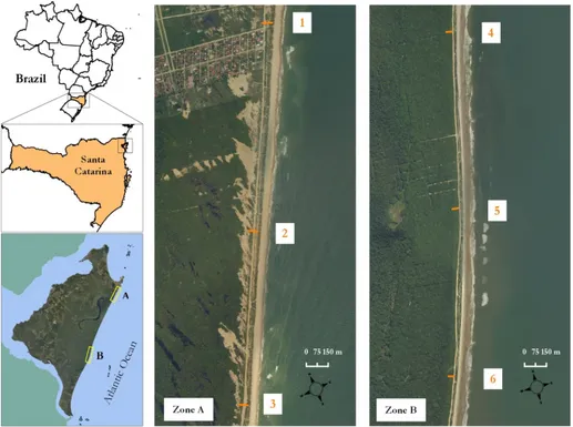
Figure 1. Geographical localization of São Francisco do Sul Island. Middle and right maps represent
the detail of Zone A and Zone B; the progressive numbers associated to the orange lines point out the transects where the CDVI have been calculated
The evaluation of the vulnerability index has been done on two sectors (Zone A and Zone B) of the largest beach on the island, Grande beach (Figure 1). These sites are located toward the northernmost (Zone A) and the central (Zone B) portion of the beach, which are characterized by two different dune types: parabolic dunes prevail in Zone A, whereas transverse dunes are predominant in Zone B.
Another relevant difference between the two areas is the human impact: Zone A is strongly affected by urbanization, while Zone B is more preserved. Both sites are encompassed within the limits of the Acaraí State Park (Figure 1). As a matter of fact, this specific area has been selected because of its naturalistic relevance, being considered as the largest remaining sector of Santa Catarina characterized by the restinga vegetation, which is in extreme need of biodiversity conservation [12].
3. Methods
The CDVI was calculated according to the protocol for the Mediterranean coasts proposed by Ciccarelli et al. [8], which was modified after García-Mora et al. [13] to meet the needs of local features. To adapt the CDVI to the oceanic setting, length and distance measures have been expressed in kilometers rather than meters. A total of six transects perpendicular to the coastline were traced out on two separate sectors (Zone A and Zone B) along Grande beach (Figure 1). The transects were spaced 1 km and started from the shoreline to the woody vegetation. The CDVI was calculated taking into account 51 quantitative and qualitative variables distributed in five greater groups: geomorphological dune system condition (GCD), marine influence (MI), aeolian effect (AE), vegetation condition (VC) and human effect (HE). To calculate the index, each variable was associated with a five-point scale, ranging from 0 (no vulnerability) to 4 (very high vulnerability). In each group, the sum of the variables was divided by the sum of the maximum achievable rating within each group, thus generating a partial index expressed as a percentage, classified in four categories: i) CDVI < 0.25 = low risk; ii) 0.25 < CDVI ≤ 0.5 = medium risk; iii) 0.5 < CDVI ≤ 0.6 = high risk; iv) CDVI ≥ 0.6 = very high risk (following García-Mora et al. [13]). The final CDVI was calculated on the unweighted average of the five partial indices through the algorithm: CDVI = (GCD + MI + AE + VC + HE)/5.
4. Results and discussions
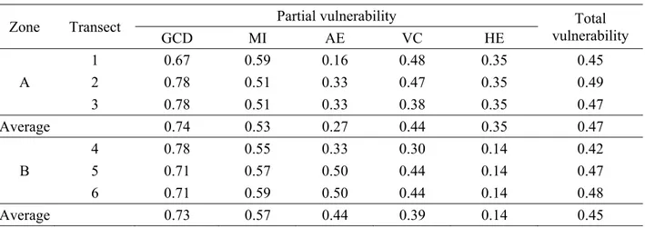
The resulting total CDVI values calculated along each transect do not show any significant difference between Zone A and Zone B and within both zones separately, ranging from 0.42 to 0.49 (Table 1). Based on this outcome, the total vulnerability of the sites can be classified as medium risk. Considering each parameter separately, no major differences can be observed as well. Only HE shows a clear separation comparing Zone A (0.35) with Zone B (0.14), thus implying that human activity is affecting less the southern sector rather than the northern one, which is actually closer to the village Praia Grande. Another exception is represented by the AE value along transect 1, which is lower relative to the other transects of Zone A (0.16 to 0.33): being the transect closest to the promontory located on the northern edge of the island, it might be affected by a partial screening of the wind (Abreu [14]).
Table 1. Partial and total CDVI values for each transect
Zone Transect Partial vulnerability vulnerability Total
GCD MI AE VC HE A 1 0.67 0.59 0.16 0.48 0.35 0.45 2 0.78 0.51 0.33 0.47 0.35 0.49 3 0.78 0.51 0.33 0.38 0.35 0.47 Average 0.74 0.53 0.27 0.44 0.35 0.47 B 4 0.78 0.55 0.33 0.30 0.14 0.42 5 0.71 0.57 0.50 0.44 0.14 0.47 6 0.71 0.59 0.50 0.44 0.14 0.48 Average 0.73 0.57 0.44 0.39 0.14 0.45
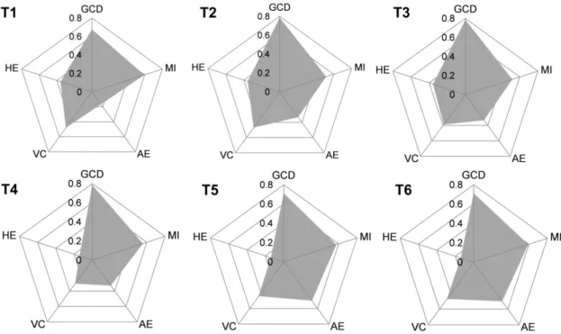
The radial plots show the impact of each parameter along the transects (Figure 2). Each axis of the plot corresponds to a vulnerability class. The vulnerability of the site is directly proportional to the surface of the radial plot: the larger the surface, the most vulnerable is the site. The parameter showing the highest CDVI values is GCD: along each transect the GCD is over 0.6, which means that the vulnerability is classified as very high risk. Zone A and Zone B present almost identical values on average (0.74 and 0.73 respectively); the lowest value (0.67 along the northernmost transect, that is transect 1) is likely a consequence of the modification on wave dynamics produced by the northern promontory as for the wind (Abreu [14]).
Figure 2. Radial plots showing partial CDVI values for each transect
The importance of the geomorphological factor on the area is obviously related to the ongoing erosion processes the beach is subjected to. As a matter of fact, the parabolic dunes characterizing Zone A show several large blowouts and the erosion of the frontal dune, which at times generates a steep scarp at the transition between the backshore and the dunes. The transverse dunes in Zone B are widely covered with fixed vegetation and do not show any blowout, but they are subjected to a strong erosion of the frontal dunes alike the dunes in the northern sector. The only other parameter whose CDVI values cross the threshold of 0.5 is MI (Table 1), but still is subordinate to the influence of GCD. GCD and MI parameters are both connected to wave and sea processes, which are relevant especially on an oceanic setting like Grande beach at São Francisco do Sul Island. Therefore, the higher energy of the oceanic environment might be responsible of the GCD parameter dominance on this site.
5. Conclusions
The application of the CDVI along Grande beach enabled to assess the vulnerability of two sectors of a coastal dune system at São Francisco do Sul Island. As a result, the total vulnerability for this site can be classified as medium: in particular, the geomorphological factor must be strictly monitored at Grande beach, because the wide blowouts in Zone A and the frontal dune retreat in Zone B rise some concerns. The high partial values of GCD and MI parameters possibly depend on the tight correlation
between geomorphological aspects and coastal morphodynamics with the characteristics of the oceanic environment, where the exposure to wave energy is higher.
Although limited to the areas where it was applied, the CDVI provided useful insights about the state of the dunes at Grande beach and proved to be a valuable tool as a guiding management policy to the coast of São Francisco do Sul. As a matter of fact, it is suggested to coastal managers and stakeholders to monitor the accretion/retreat ratio of the beach system, especially after strong storms, in order to understand whether this is a cyclic effect or erosive effect. In addition, the CDVI can be easily implemented with new variables and applied frequently to check the evolution of the site on a regular basis.
References
[1] Bertoni D, Biagioni C, Sarti G, Ciccarelli D, Ruocco M. The role of sediment grain-size, mineralogy, and beach morphology on plant communities of two Mediterranean coastal dune systems. Italian Journal of Geosciences 2014;133:271-281
[2] Ruocco M, Bertoni D, Sarti G, Ciccarelli D. Mediterranean coastal dune systems: Which abiotic factors have the most influence on plant communities? Estuarine Coastal and Shelf Science 2014;149:213-222
[3] Nicholls RJ, Cazenave A. Sea-level rise and its impact on coastal zones. Science 2010;328:1517-1520
[4] IPCC. Climate Change 2014: Impacts, Adaptation, and Vulnerability. Summaries, Frequently Asked Questions, and Cross-Chapter Boxes. A Contribution of Working Group II to the Fifth Assessment Report of the Intergovernmental Panel on Climate Change. World Meteorological Organization, Geneva, Switzerland; 2014, p. 190
[5] Satta A, Snoussi M, Puddu M, Flayou L, Hout R. An index-based method to assess risks of climate-related hazards in coastal zones: The case of Tetouan. Estuarine Coastal and Shelf Science 2016;175:93-105
[6] ETC-CCA. Methods for assessing coastal vulnerability to climate change. European Topic Centre on Climate Change Impacts. Vulnerability and Adaptation Technical Paper 1/2011; 2011.
[7] Smit B, Wandel J. Adaptation, adaptive capacity and vulnerability. Global Environmental Change 2006;16:282-292
[8] Ciccarelli D, Pinna MS, Alquini F, Cogoni D, Ruocco M, Bacchetta G, Sarti G, Fenu G. Development of a coastal dune vulnerability index for Mediterranean ecosystems: A useful tool for coastal managers? Estuarine Coastal and Shelf Science submitted
[9] Köppen, W., 1948. Climatologia: con un studio de los climas de la tierra. México: Fondo de Cultura Economica, p. 478
[10] Horn Filho NO. O Quaternário costeiro da Ilha de São Francisco do Sul e arredores, nordeste do estado de Santa Catarina – aspectos geológicos, evolutivos e ambientais. PhD dissertation. Universidade Federal do Rio Grande do Sul (Brazil); 1997, p. 312
[11] Bogo M, Souza MC, Angulo RJ, Barboza EG, Rosa MLCC. Arquitetura deposicional da barreira holocênica na porção meridional da Ilha de São Francisco do Sul, SC, Brasil. Pesquisas em Geociências 2015;42:281-295
[12] Melo Júnior JCF, Borger MR. Riqueza, estrutura e interações edáficas em um gradiente de restinga do Parque Estadual do Acaraí, Estado de Santa Catarina, Brasil. Hoehnea 2015;42:207-232
[13] García-Mora MR, Gallego-Fernandez JB, Williams AT, García-Novo F. A coastal dune vulnerability classification. A case study of the SW Iberian Peninsula. Journal of Coastal Research 2001;17:802-811
[14] Abreu JJ. Transporte sedimentar longitudinal e morfodinamico praial: exemplo do litoral norte de Santa Catarina. PhD dissertation. Universidade de Santa Catarina (Brazil); 2011, p.