sustainability
ISSN 2071-1050 www.mdpi.com/journal/sustainability Article
The Geological Characterization of Landscape in Major TV
Series: A Suggested Approach to Involve the Public in the
Geological Heritage Promotion
Francesca Romana Lugeri 1,†,*, Piero Farabollini 2,†, Roberto Greco 3,† and Vittorio Amadio 4,†
1 ISPRA Institute for Environmental Protection and Research, Geological Survey,
Via V. Brancati 48, 00144 Roma, Italy
2 Department of Geoscience, University of Camerino, 62032 Camerino (MC), Italy;
E-Mail: [email protected]
3 Geosciences Institute, Department of Geography, University of Campinas,13083-870, Campinas,
SP, Brazil; E-Mail: [email protected]
4 Department of Heritage, Architecture, Urban Planning, University Mediterranea, Reggio Calabria
89124, Italy; E-Mail: [email protected]
† These authors contributed equally to this work.
* Author to whom correspondence should be addressed; E-Mail: [email protected] or [email protected]
Academic Editor: Maria Helena Henriques
Received: 26 February 2015 / Accepted: 30 March 2015 / Published: 8 April 2015
Abstract: The characterization of natural and cultural heritage using popular entertainment, such as TV movies and series, can become an effective and original way to involve society in protecting territory and enhancing local development, thanks to the dissemination of knowledge. The aim is to make the complex aspects of landscape related to its geological and ecological assessment understandable to the public. The tools here proposed are the episodes of the TV series “Inspector Montalbano” filmed in Sicily. The stories, written by Andrea Camilleri, are located in Sicily (the biggest Italian island in the southern Mediterranean Sea), in particular with some World Heritage Sites. The natural and cultural landscapes, which provide fascinating scenery to the films, represent a meaning in the representation of the plot. At the same time, if recognized and understood, they become part of the cultural heritage of each component of the local community and of society. The cognitive process activates a virtuous circle revitalizing the links between humanity and environment. Moreover, it promotes a creative participation of the public in new policies,
oriented towards sustainable development, and tourism—especially geotourism and ecotourism—becomes an important resource, especially in these times of crisis.
Keywords: landscape; geological Heritage; communication; TV major Series; GIS; sustainability
1. Introduction
1.1. Landscape and Geological Heritage
Understanding one territory and transmitting this understanding is an age-old necessity that still holds great importance and influence in the political and economic development of contemporary society.
A correct approach to territorial and environmental analysis should follow holistic criteria, since specialized research, where the descriptive picture of environmental components becomes more detailed, at times loses sight of the primary elements and objectives.
The physical qualities of landscape (the substratum that interacts with the biotic components that rest on it), deserve appropriate consideration, for both scientific and management reasons. Moreover, there is no real separation between geological and biological processes: geology is part of all natural systems [1] and plays a primary role in the study of landforms, climate and biodiversity. The question of understanding and protecting our geological heritage has led to a scientific debate in recent years in Europe, which has provided various indications about methods and criteria for evaluating sites of geological interest.
According to the Wimbledon definition applied in the GEOSITES project run by the IUGS (International Union Geological Sciences), a geosite is a locality, area or territory identified for its geological or geomorphological interest with the intention of conservation [2].
A geomorphosite is a geomorphologic landform (a single object or a wider landscape) with a scientific, cultural and socio-economical value [3]; a landform with an attributed value can also be considered a geomorphosite [4]. Finally, geomorphosites can be considered as a “bridge between scientific research, cultural integration and artistic suggestion” [5].
Very often the term geotope is used in place of geosite generating confusion or, at the very least, uncertainties. According to the definition of geotope coined by German scientists, a geotope (geotop) is a base element of landscape (landschaftelement), in the same way as a biotope, detectable as the smallest unit of the Earth’s surface, geographically definable, and homogeneous in its structure and characteristics. In this sense, one can draw a parallel between geodiversity and biodiversity, because, although on different scales, the endogenous and exogenous processes, and the rocks (as elements of the formation of landscape), condition the evolution of environments and of biological diversity, and are the basis of spatial-temporal development of a region [6]. The relationship between the components of landscape and of the environment is very close [7–9]; the relationship between cause and effect of phenomena that concern the physical part of a territory and the biological part is mutually reciprocal, from the viewpoint of study of environmental diversity understood as integration of geodiversity and biodiversity.
On the strength of recent definitions agreed upon at national and international levels, the term “geotope” means the geological manifestations, physical elements of a territory or singularities of a landscape that exhibit scientific value as expressions of or testimony to the processes that caused and modeled the planet Earth, yet at the same time have value for their aesthetic, naturalistic, cultural, historical, touristic, and educational attributes.
In any case, the willingness to guarantee conservation of places of elevated geological interest stems from the need to ensure a conscious and enjoyable use of landscape in all its configurations for future generations. In Italy, the law “Legge Quadro sulle Aree Protette” 394/1991 [10] has as its objective, along with protection and management, that of conservation of geological singularities, paleontological formations, scenic and panoramic qualities, natural processes, and hydraulic and hydro-geological equilibriums [11,12].
The process of developing awareness that landscape is a collective asset is tied to complex causes. In Italy there are difficulties that hinder environmental education, causing deficiencies and fragmentation in people’s understanding of nature and of the importance of geological monuments.
Conservation of geosites must include the most complete understanding possible of their existence, therefore what is needed is a census, and one that is documented, widespread, and well-coordinated. Suitable instruments for the gathering of consistent and reliable data intended for the GIS database have been provided on a national level in Italy by the ISPRA (Environmental Protection and Research). The project “National Inventory Geosite” started in 2002 in order to promote an inventory of geosites at national level. It contains data and information on sites of geological, pedological and geoarcheological interest, representing a useful tool for geological knowledge and for territorial planning [13].
1.2. Sustainability Today
A new approach to raising awareness of territory even on the level of tourism (a very important resource in the post-modern world), is the basis from which to design a model of sustainable and creative development, founded on resources, re-qualification, and creativity that will spring from the ecosystematic integration of land and living beings.
It is glaringly obvious that there is a limit to the anthropic use of a territory established by the existing physical and chemical equilibrium, which, when upset, leads to a collapse of the system with socio-economic repercussions, whose relationship to the former are complex. The proper way, both scientifically and culturally, to approach the problem of sustainable management of territory and landscape, demands an informed and methodological preparation of all the environmental and social components and assimilates the fundamental element of awareness, and thus understanding, public education and participation. This approach is by now indispensable in order to address the decisional directions and the management of such an equilibrium between use and respect of territory, with the objective of a development that is sustainable for the natural and social ecosystem [6,14–16].
2. Materials and Methods
2.1. The Representation of Landscape
In order to reach a complete understanding of landscape a holistic approach, which integrates all the components of the studied system, is required.
Each individual landscape, studied at different scales, shows distinctive elements: structural, which depend on physical form and specific spatial organization; functional, which depend on relationships created between biotic and abiotic elements; and dynamic, which depend on the successive evolution of the structure [17].
Maps are the most complete tools that allow a thorough understanding and a clear image of the studied areas [6,18]. The most important GIS-based representations of the whole Italian territory are the“Carta della Natura” [19], “Map of Nature” [20] and the “Geologic Map of Italy” [21], coordinated by the ISPRA, tools to analyze landscape following a holistic approach (Figure 1).
Figure 1. The “Carta della Natura” web GIS. Physiographic units map sc. 1:250.000 [20].
The methodology takes into consideration all the components of landscape, integrating the information according to the landscape ecology theories, which consider landscape as the result of interaction among physical, biological and anthropic phenomena acting in a different spatial-temporal scale [22–28].
The recognition of the territorial reference units in the “Carta della Natura” project, is performed at different scales of analysis [19,29]. The landscape physiographic units (scale 1:250,000) are homogeneous areas, identified by a deductive reasoning, accordingly mapped and described [19]. Furthermore, they are classified following a specifically designed legend of landscape types that synthesizes, by an inductive reasoning, the associations of typical land features recognizable at a regional scale [6]. All of the units, at the different scales, are identified thanks to a synthesis of the composition
and the pattern of those elements that constitute their physiognomy [29,30]. Remote sensing and semi-automatic image classification process supervised through field controls allow us to recognize and classify the various landscape settings of the Italian territory.
Modern cartography and GIS are the best tools to represent the significant link between nature and culture: the thematic maps obtained thanks to GIS, provide us with the identification and representation of landscape at the same time they represent a powerful “medium” for communicating the territory to society. The realization of 3D geological models has recently started. The potential of 3D models is widely proven, and can be further developed; among the many features of 3D, the most representative is the display of significant images: the content of information and data inherent in the model, allows the users to configure systems evolution. In the field of earth sciences, thanks to these tools it is possible to follow the changes through time of the studied portions of the planet: from the investigable past to the present, from the present to the possible future changes [31–33].
2.2. Landscape and Media.
The characterization of natural and cultural heritage in the media by way of films and television series can become an effective and enjoyable instrument with which to involve and educate society in the protection and appreciation of territory.
The imaginary, according to Morin, is the “point of connection of image and imagination”[34] and it is cinema, a device of the imaginary, which promotes the execution of the superimposition of the subjective on the objective; that is, it realizes a “system that tends to integrate the spectator in the flow of the film” [34]. It is natural that film and TV with such exceptional potential has proved to have great power to open up one’s imagination in its use of metaphor compared with other forms of media.
“Stagecoach” by John Ford [35] was the first of many Westerns that Ford shot using Monument Valley as a location. The landscape is the scenery of the story and provides a strong contrast between the characters and their stories, close together in the carriage yet surrounded by immense space and spectacular landforms (Figure 2).
Figure 2. “Stagecoach”, John Ford’s masterpiece, 1939. The Monument Valley gives the scenes an unbelievable natural location [36].
In 1995, this film was deemed “culturally, historically, or aesthetically significant” by the United States Library of Congress and selected for preservation in their National Film Registry [37].
The many analyses about landscape in cinema from an aesthetic and expressive point of view underline its significance in the history and representation of film [38,39].
However, the relationship between the geo-morphological structure of place and its appearance has not received similar attention, nor has the intrinsic potential of generating awareness in the public been exploited by looking at the tie between geology and from of landscapes.
The term “landscape” remains in its common acceptance one that implies an “architectural” coherence. It rarely is considered a term that encompasses a perceptible expression of the result of the endogenous and exogenous forces that mold the Earth’s surface [6].
In this sense, the natural scenery of narrative works, in cinema or TV, can be used to transmit scientific information to as mass audience.
Certainly, the function of landscape in films made for the big screen is largely entertainment, and, especially today with the use of 3D, it gains additional expressive worth that are different yet not stylistically superior to those magnificent black and white images such as those mentioned in “Stagecoach”.
Cinema, due to its nature and its modality of consumption, can act as a medium for scientific communication if utilized in appropriate educational planning (in school or university courses) or in thematic reviews equipped with forums and debates.
Television programming, on the other hand, permits a greater flexibility and quick and continuous communication, such as in the transmission of analyses following a film or TV series.
This paper concentrates on TV series, which while undoubtedly less spectacular than films, nonetheless have a power to engage and captivate a wide and diverse audience.
The very nature of TV series, that is its continuity, works to raise the public’s interest: “the more the public is exposed to a given topic, the more its interest increases, and as this gradually takes place the more people want to know more” [40].
Two factors that are at first glance in opposition to one in fact work together in the educational potential of TV series: the geographical process of “locatability” that activates recognition to those who have familiarity of the places in question, and at the same time creates curiosity in those who have never seen these places (including immigrants who use TV as an instrument for gaining knowledge about their new country of residence and for learning the new language). The function of mass communication is to construct for its users an “operational map of the world” [41]. In general one can say that TV, as has been widely demonstrated, occupies in all homes, for better or for worse, not only a physical space but an imaginary one as well.
2.3. Cinema vs. TV?
It is not a contest, the narrative setting stimulates in either case paths of education utilizing different expressive modalities.
Both media offer new paths and new communication codes, powerful tools with which to divulge scientific knowledge and to involve society in a common aim: knowledge, consciousness, and participation.
Television made its entrance in the world of media with its immediate language, capable of seizing the unforeseen and in expressing simultaneousness and current events. With these resources, TV creates a tie between realities that are current as well as more or less distant, and offers the spectator an incisive and direct opportunity to acquire knowledge.
In the period of rigid conferment of specific language and codes, the “vocation” of television was identified in live recording (while that of cinema was identified as the art of editing). In more recent times, accustomed to the interactivity and the fusion of styles of speech, the media can be considered a combination of heterogeneous messages; each medium expresses itself by way of combinations of different codes and the differentiation lies in the different combination of codes, which entails adjustments and distortions of expression in the transition phase. The changes come in succession at a quick pace; new technology makes flexible and polyvalent means available, fostering an ulterior and deeper cross-over of modes of expression.
The difficulties tied to the popularization of science by way of television are, even intuitively, known by all.
The Nobel Prize winner for chemistry in 1963, Giulio Natta, provides an authoritative and synthetic description of the situation: “To inform the public of scientific and technical discoveries is not always easy. There are cases in which such discoveries are the result of a specialization based in fields whose theoretical notions are barely understood by the masses. And often, in the attempt to describe them in more accessible terms, one runs the risk of misrepresenting them. Despite this, amongst all the means to promote the public’s understanding of science, television is that which allows for an easier comprehension by way of its descriptive illustration” [42].
Problems tied to inadequate understanding of scientific language that then often require an adjustment for the public, can be circumvented increasingly by using programs with an emphasis on entertainment. By now the path of narration has been travelled, narration as “representation of facts and finalizations of content in a coherent distinct plot. The model of narration proposes … science as literature” [42]. On this path one arrives progressively at television series, so much so that one can say that science in TV is “science fiction” [40]. At this point, the promotion of knowledge depends more and more on the capacity to tell a story, and the figure of the presenter assumes a strategic importance. The promoter “engages with science as material for story-telling” [42], weaving together a sort of script, constructing a work in itself, in the most part founded on entertainment value and rhetoric.
Let us return to our project: a way of disseminating scientific knowledge, in this case the geo-sciences through films and television series by means of a television space dedicated to the description of places that constitute the natural cinematography on the big or small screen. We propose a structured program to highlight, from the geological, naturalistic, and territorial points of view, the places of significance in the history of cinema, analyzing their structure and origins, with particular attention to those of high landscape value and/or of particular territorial fragility.
The proposed format would be a brief (20 min) reexamination of the natural places that appear in a film or a television series that directly precede it, with a geologist in the studio making comments and observations about the characteristics salient to the landscapes that appear in the various scenes. He or she would begin with the aesthetic characteristics and their narrative function, and then correlate them to their geological nature using simple and accurate scientific language.
One of the most important ways that people approach knowledge about nature is perception of landscape; it is from there that communication begins. If this happens in a simple and entertaining manner, it can lead to recognition of national and world landscapes, often made famous in cinematic narration, and can activate a useful process of deeper awareness of territory, by going over stories, events and anecdotes in the making of films and correlated to the local geological structure making use of artists and performers, especially those with scientific experience.
Cognitive instruments and explanatory material are already available at the research institutes dedicated to the study of territory (Servizio Geologico Nazionale—Istituto Superiore Protezione e Ricerca Ambientale, Ordine Nazionale dei Geologi), which could finally be made use of by a wider public in a simple and effective way.
The modern scientific technologies of GIS (Geographical Information System) and WebGIS are a means of communication with high educational potential thanks to their versatility and ease of use. Used as demonstration tools, they reinforce the message and allow the public to enhance their knowledge.
The experiences of disseminating scientific knowledge, especially when it comes to the geo-sciences, have rarely gone beyond the documentary style and often have been made entertaining in an artificial way. When presented in a film, the Earth sciences often feed plots that are catastrophic and are typical of science fiction. Without taking exception to these communicative formulas, we nonetheless believe that is important to offer the public new ways that can establish the link between the story presented and scientific information about the nature of the places that host it.
Spreading knowledge about the Earth sciences by means of simple yet meticulous language is of primary importance, and is finally shared by all the institutions in charge of land use and conservation and of the prevention of risks.
In particular, it is precisely the management of geological and geomorphological heritage that demands active public participation in order to arrive at a recognition and protection of places of value. The very concept of sustainability implies an awareness of the existence of a heritage that demands protection and provisions for the future.
3. Results and Discussion
3.1. TV and the Popularization of Scientific Knowledge: A Proposal for the “Inspector Montalbano” Series
Indeed, the results of these studies consist in a format: we are confident that the effects of this proposal can activate a better social awareness as well as virtuous behaviors.
We tried to connect and integrate the complex aspects of landscape in some areas of particular interest with the aim to make them more understood by the public by using a new instrument of communication, film and especially television series, which arrive at a much wider audience.
An interesting and successful experience has been realized within the “GeoloGiro”: a project: developing an original link between landscapes and sports, such as road cycling events, e.g., the “Giro d’Italia” [43]. Cycling, popular sport par excellence, which has retained its identity over time, represents a spatial-temporal relationship between individuals, communities and societies [44]. The Giro d’Italia is the most appreciated race in our country: from two tiers, a geologist had the chance to explain the
geo-morphological arrangement of the areas crossed by the riders, during the live TV transmission of the stage.
The Italian television series “Inspector Montalbano”, which has viewers all around the world, is filmed in Sicily (Figure 3) where Andrea Camilleri’s novels, on which the series is based, are set. We chose this particular series because of the quality of the writing and the adaptation to the television series, fundamental to the popularity of the series and of its characters, but more importantly because many episodes are located and filmed in UNESCO World Heritage sites [44,45] such as Noto, Ragusa Ibla, Modica, Scicli, Agrigento, and Siracusa (Figure 4). Moreover, Sicily represents in the national and international imagination the dualism of value/fragility that characterizes many of its most beautiful and well-known tourist destinations, as so many are in other regions of Italy.
Figure 3. The Carta della Natura web GIS. Physiographic units map sc. 1:250.000 of the Sicily region [20].
Figure 4. The Carta della Natura web GIS. Satellite image of the South of Sicily, where some WHS sites are located [20].
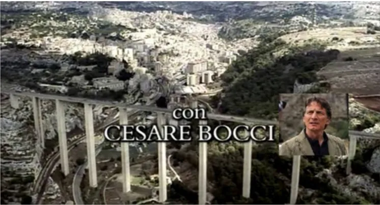
The landscapes that make up the background to the series are spectacular and they assume a significance in the representation of the plot. At the same time, if recognized, understood, and decodified in their natural history and their value, they become part of everyone’s cultural heritage; it is this cognitive process that activates a virtuous cycle that revitalizes the ties between humanity and the environment and fosters a more creative participation from everybody for a balanced management of territory and sustainable development, an important resource in these times of crisis (we are thinking of tourism and its potential in geotourism, ecotourism, etc.). Another reason in choosing this particular TV series is the presence of Cesare Bocci [44,45], the actor who plays the role of deputy to Inspector Montalbano, and who has a degree in Geological sciences: this combination suggests a further appeal to the public, as well as an authoritative contribution to the potential of the filmic communication in the popularization of the natural and cultural heritage (Figure 5). Character, actor and geologist; the coexistence of these roles in a single figure coincides with the definition of “interpreter”, a new way in the mediation between nature and culture in a landscape perspective approach. Thanks to the constant presence of a familiar and competent figure that is able to guide the public through the places that set the backdrop for the series, a journey through landscape becomes a journey through the Earth sciences [46]. The empirical-experimental approach in the field of communication research shows that identical messages have varying effectiveness depending on if they are attributed to credible sources or not [40].
Figure 5. TV Series “Il Commissario Montalbano” (Inspector Montalbano)—An image of the trailer. In the box, Cesare Bocci.
As previously mentioned, in many episodes the geological arrangement of the landscape where the series are filmed is an important component in the dramatization of the plot. The natural scenography brings to the series a special significance; the local population, as well as the tourists, recognize the territory and better appreciate its value.
The following informational cards briefly illustrate the type of information addressed to the public preferably during a TV program directly following the episode, hosted by Cesare Bocci, who becomes a cultural mediator as performer of the history as well as interpreter of place.
The content must, however, remain available, in order to enable the user a closer examination of the issues. Web and GIS are the ideal support to integrate, develop and represent data and information in an interactive way. In particular, the GIS relative to the geological map and that of the units of landscape, realized by the ISPRA, are used (Figures 6 and 7) to identify the areas, by a homogenous landscape or a typifying pattern, of special interest and sites with specific characteristics. It is the same principle used for the reconnaissance of the territory, the identification of landscape units and their classification
according to “types of landscape”, described above in regards to the “Carta della Natura”. The recognition process, triggered in the audience by seeing images of the landscape, is enriched with a new awareness brought about by the scientific information provided in an appropriate and understandable way that is connected to the story.
In order to describe and explain all the sites, the landscapes and their characteristics, it is often necessary to use technical terms; the meaning will be explained verbally by the “interpreter” and a special glossary will be provided for those who access the information via the internet.
Communicating natural and cultural heritage through movies and TV series could thus represent a new way to involve the public in a common consciousness of territory, and help to promote eco-tourism and sustainable development in Italy.
Figure 6. Geologic map of Italy. South of Sicily. sc 1:1.000.000 [21]. 3.2. The Location
The general overview refers to the area where the episodes of “Inspector Montalbano” are set, which is interesting from a landscape and geomorphological perspective.
The structures are inserted in a landscape context characterized by carbonatic shelves described as: Areas formed by a large shelf inlined towards southwest, separated from the shelf of Modica by
the large fluvial incision of the Irminio River in the east, and by mountainous elevations in the northwest, and delimited in the southeast and southwest by lower tabular elevations.
The maximum elevation (about 700 m) is found in the extreme north, and gradually diminishes towards the southwest.
The energy of the elevation is generally quite low, except for the fluvial incisions where it is locally higher.
The emerging lithology is represented by compact limestone, limestone and marlstone of the Langhian stage 1597–1382 million years ago (Ma) to the Serravallian stage (the Miocene stage 1382–11,608 Ma).
The hydrographic network is a type of radial centrifuge, the valleys mainly have their origin in the central part of the shelf and they deepen gradually articulated downward. Some of these display a straight course that shows their tectonic origin.
The paths of water wind following the incisions of the valleys. In the east there are larger valleys that delimit this area.
The principal waterways, fed by small flows, have a dendrite pattern with a low density of drainage.
The shelf is homogenous with a flat or slightly undulating summit, interrupted only by fluvial incisions that form small gullies.
The ground is cultivated (arable) with woody vegetation in the valleys and on some of the shelf in the south.
The main urban center is Ragusa, which appears on the northeastern margins. Industrial settlements are present. There is widespread discontinuous urbanization.
The main paths of communication form around Ragusa. 3.3. The Town
Ragusa is the city in which many scenes were filmed. In the books Camilleri gives it the fictional name of Vigata.
The local geolithological layout is characterized by:
“Bituminous limestone”—part of the so-called “Tripoli Formation”: an alternation of diatomaceous white laminitis and marl diatomite, that assume at depth the dark color from hydrocarbon impregnation.
Messinian lower—Late Miocene (radiometric dating from 6.9 to 6 Ma).
The “Bituminous limestone” originates by deposits of mud in closed marine basins rich in decomposing organic material. Then the bitumen forms, giving it its characteristic black color.
In this type of rock, it is usual to find plant and animal fossils.
Locally this stone is called “pitch”. It has literally built Ragusa, also from an economic point of view, making the city known all over the world, where the ore was exported to pave the roads and for the extraction of oil and fuels. In the Miocene bituminous limestone of Ragusa, fossilized remains of Squalodon bariensis (an extinct whale, with a long-toothed rostrum) were found (Figure 7).
Figure 7. A representation of a Squalodon [47]. Let us examine a few episodes of the series.
3.4. Par Condicio (Equal Time)
This is TV movie from 2002, directed by A. Sironi [48] from the short stories collection “Un mese con Montalbano” [49].
The opening and closing scenes are set in the Custonaci quarries (Figure 8). Custonaci, in the province of Trapani, is an important center for the extraction of a so-called marble (the second in Italy) in particular for the prestigious “pearled of Sicily”, which is exported around the world.
Figure 8. A scene of the episode “Par Condicio” in Custonaci quarries: the crime scene [48]. This rock is not really a marble (metamorphic rock), it is effectively made of limestone and calcirudite (sedimentary rocks) sedimented in marine environments that are not excessively deep where it enriches itself with fossils that give the stone its characteristic graduated shadings.
Due to the presence of some lavas intercalaterd to the limestones, some researchers interpret the geological setting of Custonaci as a guyot (an underwater volcano smoothed by the motion of waves) with a cap of “pearled marble” (Figure 9) with Rudiste (the so-called “pearls”), bivalves of the shallow sea [50].
Figure 9. The so-called “pearled marble” with Rudists (“pearls”), in the Rudistae-bearing hat in the Cretaceous of Custonaci [50].
Guyots (most common in the Pacific Ocean) are underwater elevations of volcanic origin, in the form of a cut off cone, that have been exposed to the erosive action of the sea and of meteoric agents during the period of emersion. The ancient crater becomes filled in by sediment coming from the breaking up of the cone, mixed together with organic material belonging to coral colonies. At a later stage, caused by subsidence movements, the summit lowers below sea level to an average depth of 1000–2000 m, and
on this flat summit there are fossil colonies of organisms that are typical of greater depths, which bear witness to the collapse of these structures (Figure 10).
Figure 10. A guyot scheme.
The key moment of the episode “Par condicio” is located in the so-called “latomie” in Ragusa. Latomia means “cut stone” (Figures 11 and 12). These ancient quarries are lithologically composed of tyrrhenian calcarenites: in the SE of Sicily, this kind of stone is very soft and friable, in the local dialect it is called “giuggiulena” (sesame seeds) because they crumble into granules of dimensions similar to sesame seeds. The same rock is elsewhere called “tufo”, a term instead that in geology identifies the pyroclastic rocks.
Figure 11. A detail of the latomie in Ragusa [48].
Figure 12. A scene in the latomie (“Par Condicio”): a secret meeting between the oldest bosses of Mafia families [48].
3.5. “La Danza del Gabbiano” (The Dance of the Seagull)
This is TV movie from 2011, directed by A. Sironi [51] from the novel “La danza del gabbiano” [52]. The most dramatic scenes of this episode take place in a karst area (Figure 13).
The Hyblaean Mountains are geologically composed of underwater volcanic expansions from the Neogene, the geological period of the Tertiary that began 24 million years ago, and have risen along with powerful limestone platforms in the form of plateaus and shelves.
The Hyblaean plateau is today deeply carved by ravines dug out by streams, locally known as “cave”, long and deep narrow gorges between steep slopes, and cliffs of white limestone and similar in their morphology to the “canyons” of North America.
From a morphological point of view, most of the area is a plateau, in part basaltic, mainly carbonatic, deeply cut by a dendritic web of valleys.
The valleys or ravines incised in the Miocenic carbonatic series, display details of fluvial-karstic morphologies produced by the mechanic erosion of water and the chemical corrosion of the limestone by acidic water. The widespread karstification, especially in the eastern part of the area, shows itself both as a superficial morphology, such as karren on the slopes, small basins of dissolution and furrows of various types, as well as karstic fossil channels at varying levels.
On the valley floors there are sinkholes, in the most part hidden beneath alluvial material and spring caves, which feed the superficial flow.
The alternation of the limestone plateau and the gorges, creates a unique landscape, characteristic of the Hyblaean Mountains, arid for the phenomenon of karst, whereas the deep quarries, in contrast, have lush vegetation because of the constant presence of water in rivers and streams and limited sunshine that allows many plant species to survive the scorching Sicilian summers.
Figure 13. A scene in “La danza del gabbiano” RAI 1: The police are looking for an officer that mysteriously disappeared [51].
3.6. “Il Senso del Tatto” (The Sense of Touch)
This is a TV from movie 2005, directed by A. Sironi [53] from the short stories collection “Gli arancini di Montalbano” [54].
Figure 14. Another crime scene, located in Favignana Island—Roman pools [53].
The Aegadian archipelago, a (marine protected area) [55], located in the Sicilian channel, lies on the continental shelf of western Sicily, representing a lateral branch of the northern mountain chain with which it shares its geological nature, signaling the presence of vast deposits of limestone on much of the seabed that extend between the islands of Favignana and Levanzo (Figure 14). The area of the shelf on which the archipelago stands on is characterized by various erosive and sedimentary forms that favored a sharp zoning of submerged vegetation. In this area, the continental shelf has an extension of about 10 km, which is one of the widest in all of Sicily. The morphology of the seabed is very irregular: large flat areas alternate with stretches of steep seabed. In the area it is possible to distinguish two zones: the first comprising the islands of Favignana and Levanzo, joined to the mainland by a slight depression, the second includes only the island of Marettimo, separated from Favignana and Levanzo by a 350 m deep channel that has been separated from the mainland since the Pliocene.
Figure 15 The Aegadian archipelago [10].
The whole channel is crossed by strong ocean currents related to the surface circulation of the area. The depths contain medium-fine sands, with a prevalence of two components: biolite originating from shells, and limestone, which is derived from the erosion of rocky outcrops.
4. Conclusions
New environmental problems require the development of new models of study and creative management strategies. An important value, referring to the social aspects of the geoheritage, is represented by the promotion of local actions to restore, protect and sustainably exploit the interested areas. Possible path for a new development could start from the idea of taking advantage of the natural environment so that it is productive for the local economy, such as the application of eco-tourism, already successfully applied in many places [6].
As ratified in the European Landscape Convention [56] “landscape is everywhere and is an essential element of quality of life and cooperates in the development of local cultures”, thus it represents a fundamental component of Europe’s cultural and natural assets and contributes to the well-being and satisfaction of human beings. Adequate measures to safeguard, manage and wisely develop territory can lead to the creation of new jobs. The innovation introduced by the Convention is its intent to attain sustainable development founded on a balanced relationship between social needs, economic activity and the environment.
The proposed project must obviously be placed in a broader and coordinated context, which provides integration between the TV proposal and school education. However, the more complex problem is the disinvolvement of the adult population, which reveals a loss of sensitivity to the problems of territorial protection. In the proposed idea, young people, suitably activated by the action of teachers, must act as a catalyst for those not (or no longer) interested in environmental issues.
From the communicative point of view, the TV series are increasingly followed: the realization is cheaper, the audience wider. A growing number of famous actors and directors participate in the implementation of television series, in Italy as well as in the world; for example, Oscar winners Ridley Scott, producer and director of “The Good Wife”, and Glenn Close, who plays in the series “Damages”. Both of these TV series are legal thrillers and enjoy great success, and are strongly informative on the issues of rights/duties and legality. So the idea of going out “en plein air” and taking advantage of the powerful function of the individual/social identification in a story, even for environmental issues— inextricably linked to social welfare—in our opinion, can prove to be very effective
Acknowledgments
The authors wish to thank Sarah Morgan, Cesare Bocci and RAI Fiction Author Contributions
The presented research was conjointly designed and elaborated. The discussion were realized conjointly by all authors and all authors contributed equally in the writing of this paper. All authors have read and approved the final manuscript
Conflicts of Interest
References and Notes
1. Brilha, J. Geoconservation and protected areas. Environ. Conserv. 2002, 29, 273–276. 2. Wimbledon, W.A.P. Geosites—A new conservation initiative. Episodes 1996, 19, 87–88.
3. Panizza, M. Geomorphosites: Concepts, methods and example of geomorphological survey. Chin Sci. Bull. 2001, 1, 4–5.
4. Panizza, M.; Reynard, E. Géomorphosites: définition, évaluation et cartographie. Géomorphologie: Relief, Processus, Environnement 2005, 3, 177–180.
5. Panizza, M.; Piacente, S. Geomorphosites: A bridge between scientific research, cultural integration and artistic suggestion Geomorphological sites and geodiversity. Il Quaternario—Italian J. Q. Sci. 2005, 18, 3–10.
6. Lugeri, F.R.; Amadio, V.; Cardillo, A.; Bagnaia, R.; Lugeri, N. Landscapes and Wine Production Areas: A Geomorphological Heritage. Geoheritage 2011, 3, 221–232.
7. Gray, M. Geodiversity: Developing the paradigm. Proc. Geolog Assoc. 2008, 119, 287–298. 8. Ruban, D.A. Quantification of geodiversity and its loss. Proc. Geolog Assoc. 2010, 121, 326–333. 9. Pereira, D.I.; Pereira, P.; Brilha, J.; Santos, L. Geodiversity assessment of Parana State (Brazil): An
innovative approach. Environ. Manag. 2013, 52, 541–552.
10. Law Framework for the Protected Areas 394/1991, Legge quadro sulle aree protette (GU Serie Generale n. 292 del 13-12-1991—Suppl. Ordinario n. 83).
11. Henriques, M.H.; Keynesménio, N. Geoheritage at the Equator: Selected Geosites of São Tomé Island (Cameron Line, Central Africa). Sustainability 2015, 7, 648–667.
12. Loures, L.; Loures, A.; Nunes, J.; Panagopoulos, T. Landscape Valuation of Environmental Amenities throughout the Application of Direct and Indirect Methods. Sustainability 2015, 7, 794–810.
13. Inventario Nazionale dei Geositi. Available online: http://www.isprambiente.gov.it/it/progetti/ suolo-e-territorio-1/tutela-del-patrimonio-geologico-parchi-geominerari-geoparchi-e-geositi/il- censimento-nazionale-dei-geositi?set_language=it (accessed on 19 March 2015).
14. Bowser, G.; Gretzel, U.; Davis, E.; Brown, M. Educating the Future of Sustainability. Sustainability 2014, 6, 692–701.
15. Yaoqing, Y.; Maozhu, J.; Jinfei, R.; Mingming, H.; Peiyu, R. The Dynamic Coordinated Development of a Regional Environment-Tourism-Economy System: A Case Study from Western Hunan Province, China. Sustainability 2014, 6, 5231–5251.
16. Darton, R.C. Scenarios and Metrics as Guides to a Sustainable Future: The Case of Energy Supply. Proc. Saf. Environ. Prot. 2003, 81, 295–302.
17. Amadio, V. Analisi di Sistemi e Progetti di Paesaggio; Franco Angeli: Milano, Italy, 2003; p. 236. 18. Martínez-Graña, A.M.; Goy, J.L.; Zazo, C. Cartographic-environmental analysis of the landscape in natural protected parks for his management using GIS. Application to the natural parks of the “Las Batuecas-Sierra de Francia” and “Quilamas” (Central System, Spain). J. Geogr. Inf. 2013, 5, 54–68.
19. Carta della Natura alla Scala 1:250,000: Metodologie di Realizzazione; APAT Manuali e linee guida 17/2003; APAT: Roma, Italy, 2003; p. 103.
20. Web GIS Carta della Natura. Available online: http://geoviewer.isprambiente.it/ index_CdN.html?config=config_CdN.xml (accessed on 8 January 2015).
21. Portale del Servizio Geologico d’Italia. Available online: http://www.isprambiente.gov.it/it/servizi- per-lambiente/portale-del-servizio-geologico-ditalia/ (accessed on 8 January 2015).
22. Troll, C. Luftbildplan und Okologiske Bodenforschung. Zeitschrift der Gesellschaft für Erdkunde Zu Berlin 1939, 74, 241–298.
23. Troll, C. Die geografische Landschaft und ihre Erforschung; Springer: Heidelberg, Germany, 1950; pp. 163–181.
24. Forman, R.T.T.; Godron, M. Landscape Ecology; Wiley: New York, NY, USA, 1986, p. 620. 25. O’Neill, R.V.; de Angelis, D.L.; Waide, J.B.; Allen, T.F.H. A Hierarchical Concepts of Ecosystems;
Princeton University Press: Princeton, NJ, USA, 1986; p. 253.
26. Naveh, Z.; Lieberman, A.S. Landscape Ecology Theory and Application; Springer Series on Environmental Management; Springer: New York, NY, USA, 1994; p. 360.
27. Forman, R.T.T. Land Mosaics: The Ecology of Landscapes and Regions. Cambridge University Press: Cambridge, UK, 1995; p. 632.
28. Turner, M.G.; Gardner, R.H.; O’Neill, R.V. Landscape Ecology in Theory and Practice: Pattern and Process; Springer: New York, NY, USA, 2001; p. 401.
29. Amadio, V.; Amadei, M.; Bagnaia, R.; Di Bucci, D.; Laureti, L.; Lisi, A.; Lugeri, F.R.; Lugeri, N. The role of Geomorphology in Landscape Ecology: the Landscape Unit Map of Italy, Scale 1: 250,000 (“Carta della Natura” Project). In Applied Geomorphology: Theory and Practice; Allison, R.J., Ed.; Wiley: London, UK, 2002; pp. 265–282.
30. Dramis, F.; Bisci, C. Cartografia Geomorfologica, Manuale di Introduzione al Rilevamento ed alla Rappresentazione degli Aspetti Fisici del Territorio; Pitagora editrice: Bologna, Italy, 1998; p. 215. 31. Martínez-Graña, A.M.; Goy, J.L.; Zazo, C.Z. Natural Heritage Mapping of the Las Batuecas-Sierra
De Francia and Quilamas Nature Parks (SW Salamanca, Spain). J. Maps 2011, 7, 600–613.
32. Martinez-Graña, A.M.; Goy, J.L.; Cimarra, C. 2D to 3D geologic map transformation using virtual globes and flight simulators and their applications in the analysis of geodiversity in natural areas. Environ. Earth Sci. 2014, doi:10.1007/s12665-014-3959-1.
33. Martínez-Graña, A.M.; González-Delgado, J.A.; Pallarés, S.; Goy, J.L.; Civis, J. 3D Virtual Itinerary for Education Using Google Earth as a Tool for the Recovery of the Geological Heritage of Natural Areas: Application in the “Las Batuecas Valley” Nature Park (Salamanca, Spain). Sustainability 2014, 6, 8567–8591.
34. Morin, E. Il cinema o l’uomo Immaginario; Feltrinelli: Milano, Italy, 1982. 35. Stagecoach. Directed by Ford John, 1939.
36. FilmScore. Available online: http://filmscoremonthly.com/board/posts.cfm?threadID=70779 (accessed on 8 January 2015).
37. Canova, G. Enciclopedia del Cinema; A cura di, Garzanti: Milano, Italy, 2002; pp. 391, 942. 38. Bernardi, S. Il paesaggio nel cinema italiano; Marsilio: Venezia, Italy, 2004; p. 212.
39. Harper, G.; Rayner, J. Cinema and Landscape-Film, Nation and Cultural Geography; Intellect: Bristol, UK, 2010.
40. Wolf, M. Teorie della Comunicazione di massa Bompiani; Internet Bookshop Italia: Milano, Italy, 1996; p. 31.
41. Cohen, B.C. The Press and Foreign Policy; Princeton University press: Princeton, NJ, USA, 1963. 42. Grasso, A. Enciclopedia della Television; Garzanti: Milano, Italy, 2002; pp. 375–382.
43. Farabollini, P.; Graziano, G.; Lugeri, F.; Lugeri, M.; Lugeri, N. Paesaggio, Ambiente Naturale e Culturale in un Approccio Sistemico per la Divulgazione delle Geoscienze; Geologia Tecnica & Ambientale: Roma, Italy, 2013; pp. 64–75.
44. Lugeri, F.R.; Farabollini, P.; Graziano, G.; Amadio, V. GEOHERITAGE: Nature and culture in a landscape approach. Eur. Geol. 2012, 34, 23–28.
45. Lugeri, F.R.; Graziano, G.; Farabollini, P.; Amadio, V. The landscape approach and the popularization of the geo-environmental heritage. In Proceedings of 7th EUropean Congress on REgional GEOscientific Cartography and Information Systems, Bologna, Italy, 2012; pp. 344–345. 46. Farabollini, P.; Lugeri, F.R.; Amadio, V.; Aldighieri, B. The role of Earth Sciences and Landscape Approach in the Ethic Geology: Communication and Divulgation for the Prevention and Reduction of Geological Hazards; Springer: Heidelberg, Germany, 2014; Volume 7, pp. 115–120.
47. Squalodon, pencil drawing, digital coloring by Tamura Nobu. Available online: http://commons.wikimedia.org/ (accessed on 8 January 2015).
48. Par Condicio TV movie. Directed by A. Sironi, produced by RAI Fiction–Palomar, 2002. 49. Camilleri, A. Un mese con Montalbano; Mondadori: Milano, Italy, 1998.
50. Montanari, L. Geologica Sicula; Collana Studi e Ricerche dell’Agenzia Regionale per la Protezione dell’ Ambiente: Sicilia, Italy, 2004; p. 153.
51. La danza del gabbiano. TV movie, Directed by A. Sironi, produced RAI Fiction–Palomar, 2011. 52. Camilleri, A. La danza del Gabbiano; Sellerio: Palermo, Italy, 2009.
53. Il senso del tatto—TV movie. Directed by A. Sironi, produced by RAI Fiction–Palomar, 2005. 54. Camilleri, A. Gli arancini di Montalbano; Il senso del tatto Mondadori: Milano, Italy, 1999. 55. Associazione Ampegadi. Available online: http://www.ampegadi.org (accessed on 8 January 2015). 56. Council of Europe. European Landscape Convention. Florence 20.X.2000. European Treaty Series. Available online: http://conventions.coe.int/Treaty/en/Treaties/Html/176.htm (accessed on 8 January 2015).
© 2015 by the authors; licensee MDPI, Basel, Switzerland. This article is an open access article distributed under the terms and conditions of the Creative Commons Attribution license (http://creativecommons.org/licenses/by/4.0/).
![Figure 1. The “Carta della Natura” web GIS. Physiographic units map sc. 1:250.000 [20]](https://thumb-eu.123doks.com/thumbv2/123dokorg/5391558.57172/4.892.185.710.475.861/figure-carta-della-natura-web-gis-physiographic-units.webp)
![Figure 2. “Stagecoach”, John Ford’s masterpiece, 1939. The Monument Valley gives the scenes an unbelievable natural location [36]](https://thumb-eu.123doks.com/thumbv2/123dokorg/5391558.57172/5.892.251.649.803.1106/figure-stagecoach-masterpiece-monument-valley-unbelievable-natural-location.webp)
![Figure 3. The Carta della Natura web GIS. Physiographic units map sc. 1:250.000 of the Sicily region [20]](https://thumb-eu.123doks.com/thumbv2/123dokorg/5391558.57172/9.892.224.672.386.704/figure-carta-della-natura-physiographic-units-sicily-region.webp)
![Figure 6. Geologic map of Italy. South of Sicily. sc 1:1.000.000 [21]. 3.2. The Location](https://thumb-eu.123doks.com/thumbv2/123dokorg/5391558.57172/11.892.204.692.382.741/figure-geologic-map-italy-south-sicily-sc-location.webp)
![Figure 7. A representation of a Squalodon [47]. Let us examine a few episodes of the series](https://thumb-eu.123doks.com/thumbv2/123dokorg/5391558.57172/12.892.245.652.924.1102/figure-representation-squalodon-let-examine-episodes-series.webp)
![Figure 8. A scene of the episode “Par Condicio” in Custonaci quarries: the crime scene [48]](https://thumb-eu.123doks.com/thumbv2/123dokorg/5391558.57172/13.892.242.655.302.519/figure-scene-episode-condicio-custonaci-quarries-crime-scene.webp)
![Figure 11. A detail of the latomie in Ragusa [48].](https://thumb-eu.123doks.com/thumbv2/123dokorg/5391558.57172/14.892.228.656.589.809/figure-a-detail-of-the-latomie-in-ragusa.webp)
![Figure 13. A scene in “La danza del gabbiano” RAI 1: The police are looking for an officer that mysteriously disappeared [51]](https://thumb-eu.123doks.com/thumbv2/123dokorg/5391558.57172/15.892.255.638.718.943/figure-scene-gabbiano-police-looking-officer-mysteriously-disappeared.webp)
![Figure 14. Another crime scene, located in Favignana Island—Roman pools [53].](https://thumb-eu.123doks.com/thumbv2/123dokorg/5391558.57172/16.892.239.655.114.362/figure-crime-scene-located-favignana-island-roman-pools.webp)
