MPM GIS PROJECT
REPORT 2010-12 AND ARCHAEOMETRIC PROTOCOLS
Mancini M.C.a*, Menozzi O. aa CAAM - Centre of Athenaeum for Archaeometry and Microanalysis
University G. d’Annunzio Chieti-Pescara, University Campus of Chieti scalo, 66013 Chieti, Italy - [email protected]
KEY WORDS: Archaeometry, GIS, geological prospecting, landscape archaeology, geo-archaeology, DGPS mapping.
ABSTRACT:
The project is mainly focused on the study of the landscape assessment in the area of Moni, Pyrgos and Monagroulli (Limassol-Cyprus), which represents a very interesting topographical and archaeological area. A large team, including scholars and students coming from different Italian and Spanish institutions, is using the traditional methodologies for studies of landscape archaeology (intensive and judgmental survey, GIS mapping, DGPS location of the sites, studies on typologies, distribution and statistics of pottery finds), in combination with methodologies and technologies integrating information, such as Remote Sensing on aerial photos and on high definition panchromatic satellite photos, geo-morphological reconstruction of the context, archaeometric analysis of the finds and of the building materials, non invasive geo-archaeological prospecting. The project started in 2010 and already at the preliminary stages is giving interesting results. The aim of this paper is the presentation of the project, concentrating here mainly on the archaeometric protocols, analysis and preliminary results.
1. THE PROJECT (O.M.) 1.1 Aims and team
The team of Chieti University, involving both the Centre of the Athenaeum for Archaeometry and Microanalysis (CAAM) and the Department of Psychology, Humanities and Territorial Sciences (DiSPUTer) of the University of Chieti, and the Italian Ministry for Cultural Heritage (MIBAC), has started a collaboration, both on archaeological, topographical and geophysical bases, with the Director of the Italian Mission at Pyrgos, Dr M.R. Belgiorno (ITABC-CNR Rome) since 2008, with limited topographic and geophysical surveys.
However, since 2010, the team started, thanks to permission of the Department of Antiquities of Cyprus, surveying and mapping the territories of Moni, Pyrgos and Monagroulli (Limassol-Cyprus), for a wide and complete study of the landscape assessment of the area, in order to reconstruct the meaning of the changes of the settlement patterns through the centuries, from prehistory till the middle age
(Belgiorno,
Fossataro, Menozzi, forthcoming
).The team is mainly working in reconstructing the ancient landscape assessment with the application of different technologies and archaeological, geological and environmental protocols, which have been widely tested and codified by our team in some international projects in Libya (Menozzi, Fossataro 2010a), Egypt and Cyprus (Bombardieri, Menozzi, Fossataro 2009, 2010; Menozzi, Fossataro 2010b).
The aim of the project is therefore the study of this territory (Fig.1) which finds its morphological and topographic limits on the hills and ridges to the west of Pyrgos (which represent also the natural and administrative boundary with the municipality of Parekklesia- Limassol), in the area of Monagroulli to the east, in the mountainous slopes behind Mazokambos to the north and the seacoasts to the south, delimiting therefore a territory very interesting for remains, settlements, geological and topographic features.
Considering the lack of mapping and localization of the numerous finds and remains in this territory, the project has been planned for mapping the remains within the area, employing both traditional and instrumental survey of this interesting area in order to produce archaeological maps and GIS, on topographic, cadastral and high definition satellite bases including the main mineral and hydro-geological resources, the ancient road-network and the distribution of ancient sites and finds.
This territorial study is mainly based on a multidisciplinary scientific approach, involving archaeologists specialized in different periods, geo-archaeologists and geo-morphologists, topographers and archaeometrists, guaranteeing a more complete study of the area both diachronically and synchronically, which is generally very rare for survey projects. Moreover, the possibility of limited soundings and excavations as stratigraphic tests allow a more critical interpretation of surface data, generally too partial if analysed just for themselves. The control of the scatter sites and finds coming from the survey is also done using different methods and technologies, such non invasive geo-prospections, Remote Sensing and photo-interpretation, and also including archaeometrical analysis of the main fabric and finds with a specific geo-archaeological survey for mapping the main sources for the pottery locally produced.
The data coming from the researches and surveys of several teams moving in the territory and the results of the analysis are converging in real time in a GIS platform which is organised in several interactive levels, allowing different views of the data and of the territory, with the possibility to change the topographic base on the bases of the needs, switching from the cadastral maps to the aerial view, to the high definition satellites images.
This typology of multilayer approach is particularly important for a research involving more teams working on different fields and strictly collaborating not only within the members of the project, but with the possibility to exchange data, views and methods with other teams working on common bases and with
the Department of Antiquity controlling directly season by season both the territory, the results and even ask for specific researches and areas.
1.2 Study of the territory: methodologies and technologies The topographic base of the project is coming from the merging of different topographic bases, cadastral maps, high definition satellite images, altimetry and topographic data coming from the Differential GPS and radar data. In this way all the information, from digital and paper cartography, can be used to draw as much details as possible, which are then organised in several layers in the GIS of the area, which is updated regularly with the data coming from the field survey, the soundings, the geophysical survey, the geomorphologic analysis and the old information on previous excavations and surveys. In this way the GIS can be used for very different purposes, such as to locate the archaeological finds and remains on the cadastral plots, as well as for a geological or environmental study of the area, or for a reconstruction of the ancient landscape assessment in different periods. Obviously a homogeneous methodology, both in the field survey and in the registration of the data, is extremely important for a complete view and exhaustive study of the territory. Therefore the database, which has been developed in access, both for the survey and for the soundings, as in other projects of our team, is based on several registration forms, working on the bases of cross links, which are then imported into the GIS project (fig.1), collecting a large amount of data and of multidisciplinary information.
The field survey is based on a combination of judgemental and intensive survey, the latter with small teams of peoples walking at a regular distance, in order to maintain a homogeneous sampling strategy. However, in steep or very hilly areas, where it is difficult to maintain peoples walking in parallel lines, the DGPS are used to stabilize the sampling strategy. Each surveyed field is therefore recorded, both in case of positive and negative finds, in a field registration form, which is then linked with further registration forms, of scatter site, structure, geo-morphological unit, find and so on. The archaeological sites are then positioned, with the DGPS, on 3D bases, and the last step is the 3D modelling of a DEM (Digital Elevation model) and a DTM (Digital Terrain Model) of the territory for a better interpretation and reconstruction of the ancient landscape assessment and for mapping in a proper way the possible ancient passages, road network and natural crossing point. The integration of the laser scanning for the monumental structures, of the plans made with the IS robotised Total Station, the data from the DGPS positioning, with the plans and drawings of the excavation can allow a reorganisation of the general plan of the sites. This step has already been started for the excavation of Pyrgos, thanks to our collaboration in the project PY.R.A.ME and a new plan of the site is now in progress with the post processing of the data coming from our seasons in 2010 and beginning 2011. Moreover, the use of aerial photo, taken by kite (with PCavet system for stabilising the camera) and drone (exacopter), gives the possibility to organise both hortho-photo-plan and stereoscopic views of the site, with the hortho-rectification in post processing. In this way, the maps and the hortho-photos of the sites can be used as base for an ‘intrasite GIS’ documentation. In the season September 2010 a new mapping of the site of Pyrgos with IS total station has been completed and also the scanning of crucial points of the excavation has been recorded. The data are now giving a new version of the plan of the site, but also plans of the chronological phases of some of the monuments and a base for
projecting new excavations, restorations and valorisation of the site. Moreover, the seasons 2011 (February, May and September-October) and 2012 (February and May) have mostly been dedicated to the survey of the territory and to the mapping of several new sites, which have also been surveyed with geophysical prospection.
One of the layer of the GIS, in fact, is already collecting the data coming from the geophysical survey. The methodologies used for these non invasive investigations consists in the use of three methods, which are quite well known and largely used in archaeological contexts, such as geo-radar, magnetometer / gradiometer and georesistivimeter. The choice of the method for each plot is made on the basis of the geo-morphology of the area, and in case of particularly interesting areas or results, a second method is combined for a better interpretation of the resulting anomalies attesting the probable presence of archaeological remains. In our 2011 and 2012 seasons we have mainly used the magnetometer/gradiometer method, employing GEM –GSM 19 Magnetometer, with double sensor with vertical setting configuration (Magnetometer+Gradiometer) working in combination with a DGPS system for the precise positioning of the plots and of the anomalies. The results have been elaborated with Surfer 8 and then filtered and imported into ArcMap 9.3, for locating precisely the anomalies and also for interpreting the anomalies in the wider view of their contexts. During this step of the project a geodatabase with magnetometric information of the anomalies has been organised, in order to create the basis for different levels of results and for comparisons with further results coming from future other analysis. The different levels of the geoarchaeological analysis, the GIS of the field surveys, the positioning of remains and so on, are elaborated in the same GIS format and project, but treated as different levels for avoiding any possibility of interference of the results and at the same time to favourite a multidisciplinary approach.
Figure 1: View of the GIS showing the density of the finds from the intensive field survey in the transect of Moni 1.3 Preliminary results
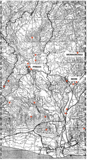
The territory of MPM Project (fig.2) is morphologically very interesting for its richness in geological and mineral resources, hydrographical network, geo-morphological units and topographic districts, giving place in antiquity to very differentiated typologies of settlements, exploitation of the resources, territorial organisations and relationships among different topographic units.
Figure 2: The area of the project with the indication of the sensible areas with possible sites, which are at the moment under investigation with non invasive geological prospection The landscape is changing a lot, from the mountainous area just at the back of Monagroulli and Mazokabos, to the hilly area of the Pyrgos valley, to the plain river terraces of the Moni valley, to the rocky and steep coasts of the area of the geological cliff just to the west of Agios Georgios Alamanos, to the flat beaches at the mouth of the rivers. Especially for this reason a team of geologists and geo-archaeologists is working on mapping the topographic and geo-morphological units (TU and GMU), in
order to have a complete view of the territory and also the geological situation in detail. At the moment the recording of the data for this aspect has been completed, and the team is now working in post processing in the interpretation of the data and in the delimitation of the TU and GMU which will be of great help then for the interpretation of the data coming from the archaeological surveys.
Two archaeological teams, composed by archaeologists, surveyors and topographers, are working in the intensive and in the judgemental surveys of the area, with about 12 sites already mapped, about 6 of them also surveyed with geophysical methods, and in 5 cases presenting also structures which have been documented and their study is still in progress.
A team of 4 scuba divers has also surveyed the coasts of this transect, in order to document more completely the geo-morphological units, giving already interesting results locating the main points geologically adapt for ancient docking, which is going to be an important information when the picture of sites and settlements is clear, to understand their relationship with possible docks and coasting trade.
Because of the richness of minerals, especially copper and iron, also a team of speleologist and archeo-speleologist is working in the survey of old mines, often showing a long frequentation, and among many surveyed mines, caves and quarries, already a possible ancient copper mine along the Pyrgos valley has already been mapped and documented, showing a possible exploitation from classical to medieval periods and then abandoned, probably because the mineral vein was finishing, and richer veins were found few kilometres to the north. The strong difference between the Pyrgos and the Moni valleys, have probably determined a completely different organization of the settlements and exploitation of the soil and resources. The Pyrgos river was flowing, in antiquity with a stronger pressure and a wider water capacity, but on very irregular bases, causing a morphology of the valley typical of a canyon / wady. This feature was certainly largely exploited in antiquity, because an interesting structure along the river has been found, documented and analysed, showing about three phases of use, since the Roman period and with Medieval and Lusignan restorations and partial re-buildings, which was used as bridge-dam, probably for creating in specific periods an artificial small ideographic basin, both for irrigating the small agricultural fields around, but mainly for serving the area of mining, located just to the north of the structure. Moreover, the area of the bridge-dam, which is known with the evocative place name of Dimmata, and of the small copper mine, is very rich in Hellenistic and roman pottery, suggesting that a possible Hellenistic-Roman settlement was there located, in close relationship with the exploitation of the mines and of the presence of abundant and drainable water. The Moni river valley, contrariwise, is and was characterised by wide alluvial plain and fertile river terraces, which are and were largely exploited for agriculture, mainly oil and wine production, as the large quantity of amphora and dolia/pithoi shards coming from the survey have attested. In this area several interesting sites have been surveyed and analysed with geophysical methods, and already at this preliminary stage of the research is possible to locate some farms and rural settlements in the area, dating to the Hellenistic and Roman periods.
Another interesting site has been surveyed in the area of Agia Marina, just 2 kilometres to the south west of Pyrgos, presenting a large quantity of finds, already at the preliminary surveys, and attesting a frequentation from the Middle Bronze Age to the Medieval period, with a possible long metallurgic activity in the area.
The already large quantity of data and finds is, during the winter seasons, post processed and more closely analysed. In the following paragraphs the protocols of the study of the pottery, both on archaeological and archaeometric bases, are presented, in order to give an idea of the work, which is still in progress, and also for looking for parallels and collaboration with other teams working in Cyprus on common bases.
2. ARCHAEOMETRIC PROTOCOLS AND ANALYSIS ON POTTERY FINDS (M.C.M.)
2.1 Protocols and analysis
Looking at the huge amount of pottery fragments, collected during our surveys, it seems to be conceivable that the economic vocation of these sites was based on the production and export of local products, importing consequently materials and different products from Mediterranean lands, especially for the period between the Middle Bronze Age and the Late Medieval Age. The pottery finds dating to these period, seem to confirm a large production, mainly agrarian, with numerous
amphorae and other containers, certainly related with the local
oil, wine and famous perfumes production and their export outside Cyprus.
The study of these pottery finds has been based on common protocols for our projects, both in Cyprus and in other areas of the Mediterranean basin, especially in Libya (Antonelli-Menozzi, forthcoming), with a sampling of the fabrics with a microscope scanning in field as first step, in order to have a preliminary digital microscope analysis as base to collect the samples. A second step, stillin situ, has been dedicated to the geo-morphological analysis of the territory, with sampling of the local clays, soils and sediments, specifically taken by geologists, in order to have possible reference samples for the local productions. Then, a third step, in laboratory, it has been based on EDX and TSA analysis, for a further grouping of the fabrics. Only few specific samples of fabric are then chosen for further investigations, such as SEM analysis, with a fourth step limited to problematic or particular fabrics.
The samples of fabrics from Cyprus, dating between a huge chronological span from Middle Bronze Age until the Late Medieval period, which have been collected counts more than 100 shards during the first step, and then we are grouping them, during the second step, in main categories. At the moment it is possible to assert the presence of a high percentage of local productions and lower percentages of imported pottery, mainly from Near East and Mycenaean and Aegean world, during the Bronze Age, and principally from Northern Africa in the Roman period. Moreover, because the amphorae and other containers were exported for their contents, we are also trying to analyze the possible remains of the contents with gas-chromatography/mass-spectrometry tests, which are still in progress and need some more samples.
The huge amount of data, coming especially from surveys is then collected into a GIS project of the area, which is a useful geo-referenced archive (on ArcMap/ArcGis bases) with a large amount of information organised in different interacting layers. The data coming from the analysis and study of the pottery is constituting specific layers concerning the archaeometrical data, the distribution of the fabrics and the location of the main areas with specific clays, fine soils and sediments, in order to have also the main provenances of finds, fabrics and raw materials and then compare them also with the layers concerning the
possible sites with agricultural productions, marked on the bases of the distribution of oil and wine presses, mills, organised storerooms, paleo-botanic analysis, amphorae andpithoi shards and so on.
2.2 Sampling of fabrics, microscope scanning and cluster analysis
Petrological approaches were applied to the identification and characterization of local and imported ware fabrics, placing them within the geological context of Cyprus. A combined of petrological and technological approach is the best application, since fine pottery and amphorae cannot be studied only on the basis of shape. The different composition from the range of fabrics will allow to identify and distinguish local fabrics from imported wares. The local and imported ware are examined in terms of technology (clay exploitation and manipulation) and provide to show characteristics and differences between pottery groups represented in the region. Typological and technological similarities will be studied in a geographical distribution of local and traded pottery circulation.
As researches stand now, we have carried out the microscope scanning of more than 100 different fabrics (the huge number of fabrics is due to the long chronological period in exam) and the geo-morphological analysis of the territory, both in situ. The preliminary results demonstrate a prevalence of local pottery production, almost certainly linked to the significant agricultural production and roman farms, suggested during the surveys by numerous amphorae fragments.
Obviously the fabrics already selected, are going to be grouped carefully on the basis of a series of features, that is: composition, association with specific typologies and forms, technologies employed in their production.
Because the step of grouping the fabric in main types and choosing the sample for further analysis is a quite delicate step of the archaeometrical protocol, we have established that this phase has to be carefully monitored both by a geologist expert in archaeometry and archaeologists aware of the need both of the archaeometric and archaeological approach ti the study of the pottery.
Hereafter, we represent same microscope scanning images of samples of the main wares and their geo-morphological composition:
COARSEWARE
CG1 – irregular, degreasing, igneus rock, heterometric, clastic, rare calcine, sub-rounded volcanic fine-grained sand, C section, pseudofluidic structure; 20 mm
AMPHORA
A5 – irregular, degreasing, fine-mid-grained sand, igneus rock, sedimentary rock, section EC, isotropic lumpy structure, low sorting; 12 mm
FINEWARE
CD4 – regular, topped, cleaned degreasing, fine-grained sand, until smooth, ECI section (E-I topped) pseudofluidic dune structure; 7 mm
RED POLISHED
CRP1 – regular, turned, smooth, topped, degreasing, calcine and igneus rock, mid-coarse sand, low smooth, section ESCSI, pseudofluidic structure; 18 mm regolare tornita lisciata ingobbiata, degrassante calcinelli e rocce ignee, sabbie medie e grossolane scarso sortito, sezione ESCSI, struttura pseudofluidale, spessore 18 mm
FINEWARE
D4 – irregular, degreasing igneus rock, limestone, mid-coarse sand, well rounded grain, bad smooth, ECI section, pseudofluidic grain structure; 13 mm
COARSEWARE
CR2 – regular, turned, inner glazed, degreasing, cleaned, calcine, igneus rock, chamotte, fine sand, well smooth, ECIV section (V= glaze), regular isotropic structure; mm. 5.
The first step of cluster analysis has identified some homogeneous typological groups, as well as Red Polished for the Bronze Age; miniature fictile for the Archaic Period; amphorae and fine wares for the Roman Age; glazed pottery for the Medieval Period, and so on. We have started a diachronic research on the Red Polished found during the survey in the area, dividing into six principal subgroups, according to typological and topped characteristics: Fine Polished; Black Topped; Metallic Ware; Red Painted; Coarse Polished; Uncertain. Completed the research of the typological studies and of the shapes, the next step will be the specific analysis. The wares from MPM project demonstrate the potential of the study of distribution and economic interaction. The imported wares attest to an interregional trade in specialized vessels with fabrics and forms adapted for particular functions, and significant trading networks extending across the Eastern Mediterranean and Aegean Sea and linking Cyprus and Northern Africa and Western Mediterranean. This important research provide an interesting source of evidences of the ancient technology and economy in Cyprus and the wider Mediterranean trade networks from the Mid Bronze Age to the Medieval Period.
2.3 Further archaeometric analysis
Further archaeometric analysis will be carried out in collaboration with the geologist Silvano Agostini, member of the Geological and Paleontological Service of the Superintendence for Archaeological Heritage of Abruzzo- Italy (MIBAC) and geologist and archaeologist of CAAM.
Thin sections and chemical analysis (microscopy, XRD) will be carried out on samples taken from some pottery finds. Data relative to the composition (MPC), technology aspects considered as a set both cultural and environmental combination (TCA), will be compared and tabulated in a standard database, according to the guidelines of an analytical protocol developed by the Geological and Palaeontological Service. A statistical analysis (through hierarchical clustering: graphs should show all the variables, single and complete bond/euclidean distances; all the variables, single and complete bond/percentage differences; only paste variable, single and complete bond/euclidean distances; only paste variables, single and complete bond / percentage differences) will be carried out on the dataset of samples to distinguish the different pastes and the production technology. For this analysis, thirty-five variables at least will be considered: minerals, fragments of sedimentary and igneous rocks, chamotte, fossils, “pedorelitti” if present, and other such petro-fabric typology, percentage and size of temper, paste typology (MPC-TCA), colour/colours on thin section with parallel nichols view interior and exterior finishing surfaces of vessels, etc. The results of the study should highlight the following features: the minerals and petrographic components will identify the main groups and single sample; the difference between the types of each group will be due to production technology and for the different degree of stylistic refinements. The temper volume percentage ranged between 5% to 30% in coarse paste mixes of the main groups. The sample marked in imported amphorae and other containers (for instance from Northern Africa or Near East) will show with a ceramic paste very different from the other samples. The preliminary results of this investigation are promising enough to encourage future research with acquisition of new and different analytical data (XRD, X-ray fluorescence,) from a larger number of samples from other archaeological sites in the Cypriot area.
3. CONCLUSIONS (M.C.M. & O.M.)
This paper gives a short account on the main findings of pottery and illustrates the preliminary results with the aim of further enhancement and completion of knowledge of populations that inhabited this region from the Middle Bronze Age to the Medieval Period.
The study focuses on Bronze Age, Archaic, Classical and Medieval wares from the survey in the Pyrgos region, in Southern Mid Cyprus. A terminus ante quem for the pottery from the sites is provided by the most ancient human settlement presents just in Pyrgos-Mavroraki, the earliest excavated context not included in this study and dating from the Mid and Late Bronze Age. The main important approach to the pottery finds during our survey is based on the combination of technological and petrological methods, applied to identification and characterization of local and imported ware fabrics. The preliminary results demonstrate a prevalence of local pottery production, almost certainly linked to the significant agricultural produce and roman farms, highlighted during surveys and numerous amphorae fragments.
REFERENCES
Anderson, J.M., Mikhail, E.M., 1998. Surveying. Theory and Practice, Boston.
Antonelli, S., Menozzi, O., forthcoming. Late Roman coarse ware and amphorae from Cyrenaica (Libya): preliminary res-ults, in LRCW4, Late Roman Coarse Wares, Cooking Wares
and Amphorae in the Mediterranean, Archaeology and Archae-ometry, Tessalonika 2011.
Banning, E.B., 2002. Archaeological Survey. New York. Belgiorno, M.R., Fossataro, D.,Menozzi, O., forthcoming. Pro-ject: Pyrgos (Limassol) and its territory; preliminary report of the 2010 archaeological investigations. Report of The
Depart-ment of Antiquities. Cyprus 2010.
Bevan, A., Conolly, J., 2004. Gis, Archaeological Survey, and Landscape Archaeology on the island of Kythera, Greece. JOURNAL OF FIELD ARCHAEOLOGY, 29, 1-2, pp. 123-138.
Bombardieri, L., Menozzi, O., Fossataro, D., 2009. The Kouris survey project: 2008 preliminary report. Report of The
Depart-ment of Antiquities. Cyprus 2009, pp. 118-129.
Bombardieri, L., Menozzi, O., Fossataro, D., 2010. Kouris
Val-ley Survey Project (Cyprus): methodologies and preliminary results, Matthiae, P., Pinnock, F., Nigro, L., and Marchetti, N.,
(Eds), ICAANE. Proceedings of the 6th International Congress on the Archaeology of the Ancient Near East 2008, vol. 2: Ex-cavations, Surveys and Restorations: Reports on Recent Field Archaeology in the Near East, Harrassowitz Verlag Wiesbaden 2010, pp. 279-293.
Capelli, C., Del Rio, A., Menchelli, S., Pasquinucci, M., 1998. Integrazione tra dati archeologici e mineropetrografici per l’individuazione dei centri produttivi delle anfore di Empoli,
Atti della V giornata Le Scienze della Terra e l’Archeometria. Bari 1998, Bologna, pp. 29-34.
Cherstich, L., Fossataro, D., Menozzi, O., 2010. GIS of the
nec-ropoleis of ancient Cyrene (Libya), Matthiae, P., Pinnock, F.,
Nigro, L., and Marchetti, N., (Eds), ICAANE. Proceedings of the 6th International Congress on the Archaeology of the An-cient Near East 2008, vol. 2: Excavations, Surveys and Restora-tions: Reports on Recent Field Archaeology in the Near East, Harrassowitz Verlag Wiesbaden 2010, pp. 313-321.
Craig, N., Aldenderfer, M., 2012. Preliminary Stages in the De-velopment of a Real-Time Digital Data Recording System for Archaeological Excavation Using ArcView. Journal of GIS in
Archaeology, I, pp. 11-22.
Domanico, L., Passoni, A., 1996. Analisi statistiche dei reperti ceramici: il caso di Sorgenti della Nova. Archeologia e
Calcol-atori 7, pp. 629-646.
K ivánek, R., 2011. The different possibilities for collaboration between Geophysical and Archaeological methods in the con-text of the research project “Neglected Archaeology” of the De-partment of Archaeology of the University of West Bohemia in Pilsen, Turbanti-Memmi, I., (Ed) Proceedings of the 37th Inter-national Symposium on Archaeometry. 12 of May 2008, Siena, pp.533-540.
Menozzi, O., Fossataro, D., 2010a. Field Survey, GIS and ex-cavations in the territory of Cyrene and Lamluda (Libya). Inter-im report of Chieti Mission. Libya Antiqua, V, pp.163-171. Menozzi, O., Fossataro, D., 2010b. Kouris Valley Project: metodologie, finalità e primi risultati, Researches in Cypriote
History and Archaeology, Jasink A.M., Bombardieri L. (Eds)
Firenze, pp. 103-120.
Paradise, T.R., 2012. Cultural Heritage Management and GIS in Petra, Jordan. Geospatial Technology Research.ArcNews, S. http://www.esri.com/news/arcnews/ summer12articles/ cultural-heritage-management-and-gis-in-petra-jordan.html (accessed 12 Jul. 2012)
Pasquinucci, M., Capelli, C., Del Rio, A., Menchelli, S., Vallebona, M., 2004. Analisi Archaeologiche e Archeometriche sulle anfore nordafricane rinvenute a Vada Volterrana (I-VII sec. d.C.). Africa Romana, 15, Sassari, pp. 1101-1114.
Rejas, J.G., Farijas, M., Burrillo, F., López, R., Cano, M.A., Sáiz, M.E., Mostaza, T., Zancajo, J.J., 2011. Comparative Ar-chaeometric Analysis by 3D laser, short range photogrammetry and hyperspectral remote sensing applied to the Celtiberian city-state of Segeda, Turbanti-Memmi, I., (Ed) Proceedings of the 37th International Symposium on Archaeometry. 12 of May 2008, Siena, pp.541-548.
Renfrew, C., Bahn, P., 1995. Archeologia. Teorie. Metodi. Prat-ica, Bologna.
Waksman, S., Y., 2007. Archaeometric and archaeological ap-proaches to ceramics, Oxford.
Acknowledgements
Let us start our acknowledgements thanking in a special way the Late D. Fossataro, for supporting greatly this research from the beginning and working in Cyprus till few days before his premature death.We would like to thank the Department of Antiquities of Cyprus and the Director Dr. Maria Hadjikosti, for their permission to work, their constant help and suggestions. A special thank goes to Dr M.R. Belgiorno (ITABC-CNR Rome) and Dr A. De Strobel for their collaborating and for supporting our research in many ways. Our acknowledgements go also to the Italian Ministry of Foreign Affaires, to the Italian Embassy and Consulate in Cyprus. We would like to thank S. Antonelli, Centre of the Athenaeum for Archaeometry and Microanalysis (CAAM), who is studying the late roman and medieval pottery and has prepared the microscope scanning materials, and S. Agostini, for his help in geological and archaeometrical analysis.