DISI ‐ Via Sommarive 14 ‐ 38123 Povo ‐ Trento (Italy)
http://www.disi.unitn.it
A FACETED ONTOLOGY FOR A
SEMANTIC GEO-CATALOGUE
Feroz Farazi, Vincenzo Maltese,
Fausto Giunchiglia and
Alexander Ivanyukovich
December 2010
Technical Report # DISI-10-061
Also: in proceedings of the 8th Extended Semantic Web
Conference (ESWC) 2011
A faceted ontology for a semantic geo-catalogue
Feroz Farazi1, Vincenzo Maltese1, Fausto Giunchiglia1, Alexander Ivanyukovich21 DISI - Università di Trento, Trento, Italy 2 Trient Consulting Group S.r.l., Trento, Italy
Abstract. Geo-spatial applications need to provide powerful search capabilities
to support users in their daily activities. However, discovery services are often limited by only syntactically matching user terminology to metadata describing geographical resources. We report our work on the implementation of a geo-graphical catalogue, and corresponding semantic extension, for the spatial data infrastructure (SDI) of the Autonomous Province of Trento (PAT) in Italy. We focus in particular to the semantic extension which is based on the adoption of the S-Match semantic matching tool and on the use of a faceted ontology codi-fying geographical domain specific knowledge. We finally report our experi-ence in the integration of the faceted ontology with the multi-lingual geo-spatial ontology GeoWordNet.
Keywords: Semantic geo-catalogues, faceted ontologies, ontology integration,
entity matching
1 Introduction
Geo-spatial applications need to provide powerful search capabilities to support users in their daily activities. This is specifically underlined by the INSPIRE1 directive and
regulations [15, 16] that establish minimum criteria for the discovery services to sup-port search within the INSPIRE metadata elements. However, discovery services are often limited by only syntactically matching user terminology to metadata describing geographical resources [1]. This weakness has been identified as one of the key issues for the future of the INSPIRE implementation [11, 17, 18, 19].
As a matter of fact, current geographical standards only aim at syntactic agreement [23]. For example, if it is decided that the standard term to denote a harbour (defined in WordNet as “a sheltered port where ships can take on or discharge cargo”) is
har-bour, they will fail in applications where the same concept is denoted with seaport.
As part of the solution, domain specific geo-spatial ontologies need do be adopted. In [14] we reviewed some of the existing frameworks supporting the creation and maintenance of geo-spatial ontologies and proposed GeoWordNet - a multi-lingual spatial ontology providing knowledge about geographic classes (features), geo-spatial entities (locations), entities’ metadata and part-of relations between them - as one of the best candidates, both in terms of quantity and quality of the information provided, to provide semantic support to the spatial applications.
The purpose of the Semantic Geo-Catalogue (SGC) project [20] - promoted by the Autonomous Province of Trento (PAT) in Italy with the collaboration of Informatica
Trentina, Trient Consulting Group and the University of Trento - was to develop a semantic geo-catalogue as an extension of the existing geo-portal of the PAT. It was conceived to support everyday activities of the employees of the PAT. The main re-quirement was to allow users to submit queries such as Bodies of water in Trento, run them on top of the available geographical resources metadata and get results also for more specific features such as rivers and lakes. This is clearly not possible without semantic support. As reported in [12], other technological requirements directly com-ing from the INSPIRE directives included (a) performance - send one metadata record within 3s. (this includes, in our case, the time required for the semantic expansion of the query); (b) availability - service up by 99% of the time; (c) capacity - 30 simulta-neous service requests within 1s.
In this paper we report our work on the implementation of the semantic geograph-ical catalogue for the SDI of the PAT. In particular, we focus on the semantic exten-sion of its discovery service. The semantic extenexten-sion is based on the adoption of the S-Match2 semantic matching tool [4] and on the use of a specifically designed faceted
ontology [2] codifying the necessary domain knowledge about geography and includ-ing inter-alia the administrative divisions (e.g., municipalities, villages), the bodies of water (e.g., lakes, rivers) and the land formations (e.g., mountains, hills) of the PAT. Before querying the geo-resources, user queries are expanded by S-Match with do-main specific terms taken from the faceted ontology. In order to increase the dodo-main coverage, we integrated the faceted ontology with GeoWordNet.
The rest of the paper is organized as follows. Section 2 describes the overall sys-tem architecture and focuses on the semantic extension in particular. Section 3 de-scribes the dataset containing the locations within the PAT and how we cleaned it. Sections 4, 5 and 6 provide details about the construction of the faceted ontology, its population and integration with GeoWordNet, respectively. The latter step allows supporting multiple languages (English and Italian), enlarging the background ontol-ogy and increasing the coverage of locations and corresponding metadata such as lati-tude and longilati-tude coordinates. Finally Section 7 concludes the paper by summarizing the main findings and the lessons learned.
2 The architecture
As described in [1], the overall architecture is constituted by the front-end, business logic and back-end layers as from the standard three-tier paradigm. The geo-catalogue is one of the services of the existing geo-cartographic portal3 of the PAT. It has been
implemented by adapting available open-source tool4 conforming to the INSPIRE
di-rective and by taking into account the rules enforced at the national level. Following the best practices for the integration of the third-party software into the BEA ALUI framework5 (the current engine of the geo-portal), external services are brought
to-gether using a portlet6-based scheme, where GeoNetwork is used as a back-end. Fig. 1
2 S-Match is open source and can be downloaded from http://sourceforge.net/projects/s-match/ 3http://www.territorio.provincia.tn.it/
4 GeoNetwork OpenSource, http://geonetwork-opensource.org 5http://download.oracle.com/docs/cd/E13174_01/alui/ 6http://jcp.org/en/jsr/detail?id=168
provides an integrated view of the system architecture. At the front-end, the function-alities are realized as three portlets for:
1. metadata management, including harvesting, search and catalogue navigation functionalities;
2. user/group management, to administer access control on the geo-portal; 3. system configuration, which corresponds to the functionalities of the
GeoNet-work's Administrator Survival Tool (GAST) tool of GeoNetwork.
These functionalities are mapped 1-to-1 to the back-end services of GeoNetwork. Notice that external applications, such as ESRI ArcCatalog, can also access the back-end services of GeoNetwork.
Fig. 1. The overall system architecture
The GeoNetwork catalogue search function was extended by providing semantic
query processing support. In particular, the analysis of the available work in the field,
such as [6, 7, 8, 9, 10, 11], summarized in [12], brought to the selection of the S-Match semantic matching operator as the best candidate to provide the semantic ex-tension of the geo-catalogue. Given two graph-like structures (e.g., XML schemas) a
GeoNetwork Web-services Front-end BEA ALUI Metadata management portlet User and group
management portlet System configuration portlet Metadata management web-service User and group
management web-service System configuration web-service Query Analysis Semantic matching Faceted ontology background ontology LDAP
Authentication ORACLE DATABASEGEO-
USER QUERY QUERY RESULT External application Semantic extension
semantic matching operator identifies the pairs of nodes in the two structures that are semantically similar (equivalent, less or more specific), where the notion of semantic similarity is both at the node level and at the structure level [13, 21, 22]. For instance, it can identify that two nodes labelled stream and watercourse are semantically equivalent because the two terms are synonyms in English. This allows similar mation to be identified that would be more difficult to find using traditional infor-mation retrieval approaches.
Initially designed as a standalone application, S-Match was integrated with GeoNetwork. As explained in [1], this was done through a wrapper that provides web services to be invoked by GeoNetwork. This approach mitigates risks of failure in ex-perimental code while still following strict uptime requirements of the production sys-tem. Another advantage of this approach is the possibility to reuse this service in other applications with similar needs.
In order to work properly, S-Match needs domain specific knowledge. Providing this knowledge is the main contribution of this paper. Knowledge about the geograph-ical domain is codified into a faceted ontology [1]. A faceted ontology is an ontology composed of several subtrees, each one codifying a different aspect of the domain. In our case, it codifies the knowledge about geography and includes (among others) the administrative divisions (e.g., municipalities, villages), the bodies of water (e.g., lakes, rivers) and the land formations (e.g., mountains, hills) of the PAT.
The flow of information, starting from the user query to the query result, is repre-sented with arrows in Fig. 1. Once the user enters a natural language query (which can be seen as a classification composed by a single node), the query analysis component translates it into a formal language according to the knowledge codified in the back-ground ontology7. The formal representation of the query is then given as input to the
semantic matching component that matches it against the faceted ontology, thus ex-panding the query with domain specific terms. The expanded query is then used by the metadata management component to query GeoNetwork and finally access the maps in the geo-database.
At the moment the system supports queries in Italian through their translation in English, uses S-Match to expand feature classes and translates them back to Italian. For instance, in the query Bodies of water in Trento only Bodies of water would be expanded. Future work includes extended support for Italian and the semantic expan-sion of the entities such as Trento into its (administrative and topological) parts.
3 Data extraction and filtering
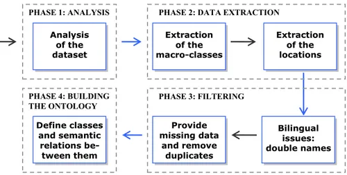
The first step towards the construction (Section 4) and population (Section 5) of the faceted ontology was to analyze the data provided by the PAT, extract the main geo-graphical classes and corresponding locations and filter out noisy data. The picture below summarizes the main phases, described in detail in the next paragraphs.
7 S-Match uses WordNet by default but it can be easily substituted programmatically, for
Fig. 2. A global view of the phases for the dataset processing 3.1 The dataset of the Autonomous Province of Trento
The data are available in MS Excel files (Table 1), and are gathered from the PAT administration. The features file contains information about the main 45 geographical classes; the ammcom file contains 256 municipalities; the localita file contains 1,507 wards and ward parts, that we generically call populated places; the toponimi file con-tains 18,480 generic locations (including inter-alia villages, mouncon-tains, lakes, and rivers). Comune, frazione and località popolata are the Italian class names for munic-ipality, ward and populated place respectively.
FILE NAME DESCRIPTION
features.xls It provides the name of the feature classes.
ammcom.xls It provides the name, id, latitude and longitude of the municipalities. localita.xls It provides the name, id, latitude and longitude of the wards and ward
parts (that we map to populated places). It also provides the id of the municipality a given ward or ward part belongs to.
toponimi.xls It provides the name, id, class, latitude and longitude of the locations. It also provides the ids of the ward or ward part and municipality a given generic location belongs to.
Table 1. The names and descriptions of the files containing PAT data
With the construction of the faceted ontology we identified a suitable name for the rest of the Italian class names from the analysis of the PAT geographical classes in the
features file. In fact, they are very generic as they are meant to contain several, but
similar, kinds of locations. For instance, there is a class that includes springs, water-falls and other similar entities.
PHASE 3: FILTERING Analysis of the dataset Extraction of the macro-classes
PHASE 2: DATA EXTRACTION
Extraction of the locations PHASE 1: ANALYSIS Bilingual issues: double names Provide missing data and remove duplicates Define classes and semantic relations be-tween them PHASE 4: BUILDING THE ONTOLOGY
3.2 Extracting the macro-classes
We retrieved the main PAT classes, that we call macro-classes (as they group differ-ent types of locations), from the features file. In this file each class is associated an id (e.g., P110) and an Italian name (e.g., Monti principali).
CODE ENGLISH NAME ITALIAN NAME
E000 province provincia E010 municipality comune
E020 ward frazione
E021 populated place località popolata
Table 2. Names of the administrative classes
We did not process the macro-class with id P310 (Regioni limitrofe) as it repre-sents locations in the neighbouring region of Trento (out of the scope of our interest) and P472 (Indicatori geografici) as it represents geographic codes. Notice that names of the macro-classes needed to be refined as they are too generic and represent many kinds of locations grouped together. As this file lacks classes for the provinces, mu-nicipalities, wards and populated places, we created them as shown in Table 2. 3.3 Extracting the locations
We imported all the locations into a temporary database by organizing them into the part-of hierarchy province > municipality > ward > populated place (and other loca-tion kinds) as follows:
The province level. We created an entity representing the Province of Trento. This entity is not explicitly defined in the dataset but it is clearly the root of the hierarchy. We assigned the following names to it: Provincia Autonoma di
Tren-to, Provincia di Trento and Trento. It was assigned to the province class.
The municipality level. Municipalities were extracted from the ammcom file. We created an entity for each municipality and a part-of relation between each mu-nicipality and the province. They were assigned to the mumu-nicipality class.
The ward and populated place level. Wards and populated places (sections of wards) were extracted from the localita file. Here each ward is connected to the corresponding municipality and each populated place to the corresponding ward by specific internal codes. For each ward and populated place we created a sponding entity. Using the internal codes, each ward was connected to the corre-sponding municipality and each populated place to the correcorre-sponding ward. They were assigned to the class ward or populated place accordingly.
All other locations. All other (non administrative) locations were extracted from the toponimi file. Here each of them is connected either to a municipality, a ward
or a populated place by specific internal codes. Using the internal codes, we con-nected them accordingly. A few of them are not concon-nected to any place and therefore we directly connected them to the province. Each location was tempo-rary assigned to the corresponding macro-class.
Locations are provided with latitude and longitude coordinates in Cartesian WGS84 (World Geodetic System 1984) format, a standard coordinate reference system mainly used in cartography, geodesy and navigation to represent geographical coordinates on the Earth8. Since in GeoWordNet we store coordinates in WGS84 decimal format, for
compatibility we converted them accordingly. 3.4 Double names: bilingual issues
Locations are provided with a name and possibly some alternative names. A few names are double names, e.g., Cresta di Siusi Cresta de Sousc. The first (Cresta di
Si-usi) is in Italian and the second (Cresta de Sousc) is in Ladin. Ladin is a language
spoken in a small part of Trentino and other Alpine regions. The combination of the two names is the official name of the location in the PAT.
In order to identify these cases, the PAT provided an extra text file for each munic-ipality containing individual Italian and Ladin version of the names. In the temporary database, we put the Italian and Ladin names as alternative names. These extra files also contain additional name variants, which are also treated as alternative names. In the end, we found 53 additional Italian names, 53 Ladin names and 8 name variants. For instance, for the location Monzoni, the Ladin name Monciogn and the name vari-ant Munciogn (poza) are provided.
3.5 Provide missing data and remove duplicates
While importing the entities in the temporary database, we found that 8 municipalities and 39 wards were missing in the ammcom and localita files respectively, and 35 mu-nicipalities were duplicated in the ammcom file9.
KIND OF OBJECT NUMBER OF THE OBJECTS IMPORTED
macro-classes 44
locations 20,162
part-of relations 20,161
alternative names 7,929
Table 3. Objects imported in the temporary database
8https://www1.nga.mil/ProductsServices/GeodesyGeophysics/WorldGeodeticSystem/ 9 Note that the missing municipalities are due to the fact that they were merged with other
mu-nicipalities on 1st January 2010, while the duplicates are related to administrative islands (regions which are not geometrically connected to the main area of each municipality).
We automatically created the missing locations and eliminated the duplicates. At the end of the importing we identified the objects reported in Table 3. Notice that here by part-of we mean a generic containment relation between locations. It can be adminis-trative or topological containment.
4 Building the faceted ontology
As mentioned in the previous section, the macro-classes provided by the PAT are very generic and are meant to contain several different, but similar, kinds of locations. This is mainly due to the criteria used by PAT during categorization that where based not only on type but also on importance and population criteria. With the two-fold goal of refining them and determine the missing semantic relations between them, we analyzed the class names and created a multi-lingual faceted ontology. Our goal was to create an ontology that both reflected the specificity of the PAT and respected the canons of the analytico-synthetic approach [5] for the generation of a faceted ontolo-gy. A faceted (lightweight) ontology [2] is an ontology divided into subtrees, called facets, each encoding a different dimension or aspect of the domain knowledge. As a result, it can be seen as a collection of hierarchies. The ontology we built encodes the domain knowledge specific to the geographical scope of the PAT and it is therefore suitable for its application in the geo-portal of the PAT administration.
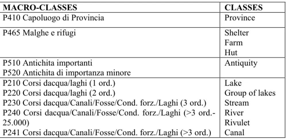
4.1 From macro-classes to atomic concepts
We started from the 45 macro-classes extracted from the feature file that we imported in the temporary database. Notice that they are not accompanied by any description. Therefore, analyzing the locations contained in each macro-class, each macro-class was manually disambiguated and refined - split, merged or renamed - and as a result new classes had to be created.
Table 4. Examples of mapping from macro-categories to atomic concepts
MACRO-CLASSES CLASSES
P410 Capoluogo di Provincia Province
P465 Malghe e rifugi Shelter
Farm Hut P510 Antichita importanti
P520 Antichita di importanza minore Antiquity P210 Corsi dacqua/laghi (1 ord.)
P220 Corsi dacqua/laghi (2 ord.)
P230 Corsi dacqua/Canali/Fosse/Cond. forz./Laghi (3 ord.) P240 Corsi dacqua/Canali/Fosse/Cond. forz./Laghi (>3 ord.-25.000)
P241 Corsi dacqua/Canali/Fosse/Cond. forz./Laghi (>3 ord.)
Lake Group of lakes Stream River Rivulet Canal
This was done through a statistical analysis. Given a macro-class, corresponding locations were searched in GeoWordNet. We looked at all the locations in the part-of hierarchy rooted in the Province of Trento having same name and collected their clas-ses. Only a little portion of the locations where found, but they were used to under-stand the classes corresponding to each macro-class. Some classes correspond to more than one macro-class. The identified classes were manually refined and some of them required a deeper analysis (with open discussions).
At the end of the process we generated 39 refined classes, including the class
prov-ince, municipality, ward and populated place previously created. Each of these
clas-ses is what we call an atomic concept. Some examples are provided in Table 4. They represent examples of 1-to-1, 1-to-many, many-to-1 and many-to-many mappings re-spectively.
4.2 Arrange atomic concepts into hierarchies
By identifying semantic relations between atomic concepts and following the analyti-co-synthetic approach we finally created the faceted ontology of the PAT with five distinct facets: antiquity, geological formation (further divided into natural elevation and natural depression), body of water, facility and administrative division. As an ex-ample, below we provide the body of water and geological formation facets.
Body of water (Idrografia) Lake (Lago)
Group of lakes (Gruppo di laghi) Stream (Corso d’acqua)
River (Fiume) Rivulet (Torrente) Spring (Sorgente) Waterfall (Cascata) Cascade (Cascatina) Canal (Canale)
Geological formation (Formazione geologica) Natural elevation (Rilievo naturale)
Highland (Altopiano) Hill (Collina, Colle)
Mountain (Montagna, Monte) Mountain range (Catena montuosa) Peak (Cima)
Chain of peaks (Catena di picchi) Glacier (Ghiacciaio, Vedretta)
Natural depression (Depressione naturale) Valley (Valle)
Mountain pass (Passo)
5 Populating the faceted ontology
Each location in the temporary database was associated a macro-class. The faceted ontology was instead built using the atomic concepts generated from their refinement. In order to populate the faceted ontology, we assigned each location in the temporary database to the corresponding atomic concept by applying some heuristics based on the entity names. They were mainly inspired by the statistical analysis discussed in the previous section. As first step, each macro-class was associated to a facet. Macro-classes associated to the same facet constitute what we call a block of Macro-classes. For in-stance, the macro-classes from P110 to P142 (11 classes) correspond to the natural
elevation block, including inter-alia mountains, peaks, passes and glaciers. Facet
spe-cific heuristics were applied to each block.
For instance, entities with name starting with Monte were considered as instances of the class montagna in Italian (mountain in English), while entities with name start-ing with Passo were mapped to the class passo in Italian (pass in English). The gen-eral criterion we used is that if we could successfully apply a heuristic we classified the entity in the corresponding class otherwise we choose a more generic class, which is the root of a facet (same as the block name) in the worst case. For some specific macro-classes we reached a success rate of 98%. On average, about 50% of the loca-tions were put in a leaf class thanks to the heuristics.
Finally, we applied the heuristics beyond the boundary of the blocks for further re-finement of the instantiation of the entities. The idea was to understand whether, by mistake, entities were classified in the wrong macro-class. For instance, in the natural
depression block (the 5 macro-classes from P320 to P350), 6 entities have name
start-ing with Monte and therefore they are supposed to be mountains instead. The right place for them is therefore the natural elevation facet. In total we found 48 potentially bad placed entities, which were checked manually. In 41.67% of the cases it revealed that the heuristics were valid, in only 8.33% of the cases the heuristics were invalid and the rest were unknown because of the lack of information available on the web about the entities. We moved those considered valid in the right classes.
6 Integration with GeoWordNet
With the previous step the locations in the temporary database were associated to an atomic concept in the faceted ontology. The next step consisted in integrating the fac-eted ontology and corresponding locations with GeoWordNet.
6.1 Concept integration
This step consisted in mapping atomic concepts from the faceted ontology to Ge-oWordNet concepts. While building GeGe-oWordNet, we integrated GeoNames classes with WordNet by disambiguating their meaning manually [14]. This time we utilized the experience we gathered in the previous work to automate the disambiguation pro-cess with a little amount of manual intervention. An atomic concept from the faceted ontology might or might not be available in GeoWordNet. If available we identified the corresponding concept, otherwise we selected its most suitable parent. This can be done using the Italian or the English name of the class. In our case we used the Italian version of the name. The procedure is as follows:
1. Identification of the facet concepts. For each facet, the concept of its root node is manually mapped with GeoWordNet. We call it the facet concept.
2. Concept Identification. For each atomic concept C in the faceted ontology, check if the corresponding class name is available in GeoWordNet. If the name is available, retrieve all the candidate synsets/concepts for it. We restrict to noun senses only. For each candidate synset/concept check if it is more specific than
the facet concept. If yes, select it as the concept for C. If none of the concepts is more specific than the facet concept, parse the glosses of the candidate synsets. If the facet name is available in any of the glosses, select the corresponding candi-date synset/concept as the concept of C.
3. Parent Identification. If the class name starts with either “group of” or “chain of”, remove this string from the name and convert the remaining part to the sin-gular form. Identify the synset/concept of the converted part. The parent of the identified concept is selected as the parent of the class. If the class name consists of two or more words, take the last word and retrieve its synset/concept. Assign this concept as the parent of the atomic concept corresponding to the class. If neither the concept nor the parent is identified yet, ask for manual intervention. 6.2 Entity matching
Two partially overlapped entity repositories, the temporary database built from the PAT dataset (corresponding to the populated faceted ontology) and GeoWordNet, were integrated. The PAT dataset overall contains 20,162 locations. GeoWordNet al-ready contains around 7 million locations from all over the world, including some lo-cations of the PAT. We imported all but the overlapping entities from the temporary database to GeoWordNet. In order to detect the duplicates we experimented with dif-ferent approaches. The entity matching task was accomplished within/across the two datasets. We found that the following rules led to a satisfactory result; two entities match if:
Rule 1: name, class and coordinates are the same Rule 2: name, class, coordinates and parent are the same
Rule 3: name, class, coordinates, parent, children and alternative names are the same As it can be noticed, Rule 2 is an extension of Rule 1 and Rule 3 is an extension of Rule 2. Parent and children entities are identified using the part-of relation. For exam-ple, Povo is part-of Trento. We have found the following results:
1. Within GeoWordNet. Applying Rule 1 within GeoWordNet we found 15,665 matches. We found 12,112 matches using Rule 2. Applying Rule 3 we found 12,058 matches involving 22,641 entities. By deleting duplicates these entities can be reduced to 10,583 entities. In fact, if two (or more) entities match by Rule 3 we can safely reduce them by deleting one and keeping the other. Matching en-tities are clearly undistinguishable.
2. Within the temporary PAT database. There are 20,162 locations in the PAT da-taset. Applying Rule 1 and Rule 2 we found 12 matches and 11 matches, respec-tively. The result did not change by applying Rule 3 as all of the matched entities are leaves and they have either the same or no alternative name. In total 22 enti-ties matched and we could reduce them to 11.
3. Across the two datasets. By applying Rule 1 we found only 2 exact matches be-tween the PAT dataset and GeoWordNet, which is far smaller than the number
we expected. Therefore, we checked the coordinates of the top level administra-tive division Trento of the PAT in these two databases manually. We found it with different, nevertheless, very close coordinates. In fact the coordinates were found as (46.0704, 11.1207) in GeoWordNet and (46.0615, 11.1108) in the PAT dataset, which motivated us to allow a tolerance while matching. The result is reported in Table 5. At the end the last one was applied, leading to 174 matches. It corresponds to Rule 3 with an offset of +/- 5.5 Km. We checked most of them man-ually and they are undistinguishable.
Same name
Same class
Same coordinates
Same parent Same Children
1385 1160
2 (exact match) 0 0
11 (using the offset +/-0.0001) 0 0 341 (using the offset +/-0.001) 13 12 712 (using the offset +/-0.01) 65 60 891 (using the offset +/-0.05) 194 174
Table 5. Matching coordinates with tolerance
Note that while matching classes across datasets, we took into account the sub-sumption hierarchy of their concepts. For example, Trento as municipality in the PAT dataset is matched with Trento as administrative division in GeoWordNet because the former is more specific than the latter. Note also that the heuristic above aims only at minimizing the number of duplicated entities but it cannot prevent the possibility of still having some duplicates. However, further relaxing it would generate false positives. For instance, by dropping the condition of hav-ing same children we found 5% (1 over 20) of false matches.
6.3 Entity integration
With this step non overlapping locations and part-of relations between them were im-ported from the temporary database to GeoWordNet following the macro steps below:
1. For each location:
a. Create a new entity in GeoWordNet
b. Use the main name of the location to fill the name attribute both in English and Italian
c. For each Italian alternative name add a value to the name attribute in Italian d. Create an instance-of entry between the entity and the corresponding class
concept
2. Create part-of relations between the entities using the part-of hierarchy built as described in Section 3.3
3. Generate an Italian and English gloss for each entity created with previous steps Note that natural language glosses were automatically generated. We used several rules, according to the language, for their generation. For instance, one in English is:
entity_name + “ is ” + article + “ “ + class_name + “ in ” + parent_name + “(“ + par-ent_class + “ in ” + country_name + “)”;
This allows for instance to describe the Garda Lake as “Garda Lake is a lake in
Tren-to (Administrative division in Trentino AlTren-to-Adige)”.
7 Conclusions
We briefly reported our experience with the geo-catalogue integration into the SDI of the PAT and in particular with its semantic extension. S-Match, initially designed as a standalone application, was integrated with GeoNetwork. S-Match performs a seman-tic expansion of the query using a faceted ontology codifying the necessary domain knowledge about geography of the PAT. This allows identifying information that would be more difficult to find using traditional information retrieval approaches. Fu-ture work includes extended support for Italian and the semantic expansion of the en-tities such as Trento into its (administrative and topological) parts.
In this work we have also dealt with data refinement, concept integration through parent or equivalent concept identification, ontology population using a heuristic-based approach and finally with entity integration through entity matching. In particu-lar, with the data refinement, depending on the cases, most of the macro-classes need-ed to be split or mergneed-ed so that their equivalent atomic concepts or parents could be found in the knowledge base used (GeoWordNet in our case). We accomplished the splitting/merging task manually supported by a statistical analysis, while the integra-tion with the knowledge base was mostly automatic. Working on the PAT macro-classes helped in learning how to reduce manual work in dealing with potentially noisy sources. Entity integration was accomplished through entity matching, which was experimented within and across the entity repositories. The entity matching crite-ria that perform well within a single repository might need to expand or relax when the comparison takes place across the datasets. Note that entity type specific matchers might be necessary when dealing with different kinds of entities (e.g., persons, organ-izations, events).
Acknowledgements
This work has been partially supported by the TasLab network project funded by the European Social Fund under the act n° 1637 (30.06.2008) of the Autonomous Prov-ince of Trento, by the European Community's Seventh Framework Programme (FP7/2007-2013) under grant agreement n° 231126 LivingKnowledge: Living-Knowledge - Facts, Opinions and Bias in Time and by “Live- Memories - Active Dig-ital Memories of Collective Life” funded by the Autonomous Province of Trento. We are thankful to our colleagues of the Informatica Trentina and in particular to Pavel Shvaiko for the fruitful discussions on the implementation of the geo-catalogue within the geo-portal of the Autonomous Province of Trento. We acknowledge Aliaksandr Autayeu for his support for the integration of S-Match. We are grateful to Veronica Rizzi for her technical support within the SGC project and to Biswanath Dutta for his suggestions for the creation of the faceted ontology. Finally, we want to thank Daniela
Ferrari, Giuliana Ucelli, Monica Laudadio, Lydia Foess and Lorenzo Vaccari of the PAT for their kind support.
References
1. P. Shvaiko, A. Ivanyukovich, L. Vaccari, V. Maltese, F. Farazi. A semantic geo-catalogue implementation for a regional SDI. In Proc. of the INPSIRE Conference, 2010.
2. F. Giunchiglia, B. Dutta, V. Maltese. Faceted Lightweight Ontologies. In “Conceptual Modeling: Foundations and Applications”, A. Borgida, V. Chaudhri, P. Giorgini, Eric Yu (Eds.) LNCS 5600 Springer, 2009.
3. F. Giunchiglia, I. Zaihrayeu. Lightweight Ontologies. The Encyclopedia of Database Sys-tems, 2007
4. F. Giunchiglia, A. Autayeu, J. Pane. S-Match: an open source framework for matching lightweight ontologies. The Semantic Web journal, 2010.
5. S. R. Ranganathan. Prolegomena to library classification. Asia Publishing House (1967). 6. I. Cruz and W. Sunna. Structural alignment methods with applications to geospatial
ontologies. Transactions in Geographic Information Science, 12(6):683–711, 2008. 7. J. Euzenat and P. Shvaiko. Ontology matching. Springer, 2007.
8. K. Janowicz, M. Wilkes, and M. Lutz. Similarity-based information retrieval and its role within spatial data infrastructures. In Proc. of GIScience, 2008.
9. P. Maué. An extensible semantic catalogue for geospatial web services. Journal of Spatial Data Infrastructures Research, 3:168–191, 2008.
10. K. Stock, M. Small, Y. Ou, and F. Reitsma. OGC catalogue services - OWL application profile of CSW. Technical report, Open Geospatial Consortium, 2009.
11. L. Vaccari, P. Shvaiko, and M. Marchese. A geo-service semantic integration in spatial data infrastructures. Journal of Spatial Data Infrastructures Research, 4:24–51, 2009. 12. P. Shvaiko, L. Vaccari, G. Trecarichi. Semantic Geo-Catalog: A Scenario and
Requirements. In Proc. of the 4th workshop on Ontology Matching at ISWC, 2009. 13. F. Giunchiglia, F. McNeill, M. Yatskevich, J. Pane, P. Besana, and P. Shvaiko.
Approximate structure-preserving semantic matching. In Proc. of ODBASE, 2008. 14. F. Giunchiglia, V. Maltese, F. Farazi, B. Dutta. GeoWordNet: a resource for geo-spatial
applications. In the Proc. of ESWC, 2010.
15. European Parliament, “Directive 2007/2/EC establishing an Infrastructure for Spatial In-formation in the European Community (INSPIRE)”, 2009.
16. European Commission, “COMMISSION REGULATION (EC) No 976/2009 implement-ing Directive 2007/2/EC as regards the Network Services,” 2009.
17. M. Lutz, N. Ostlander, X. Kechagioglou, and H. Cao. Challenges for Metadata Creation and Discovery in a multilingual SDI - Facing INSPIRE. In Proc. of ISRSE, 2009.
18. J. Crompvoets, M. Wachowicz, F. de Bree, and A. Bregt. Impact assessment of the INSPIRE geo-portal. In Proc. of the 10th EC GI&GIS workshop, 2004.
19. P. Smits and A. Friis-Christensen. Resource discovery in a European Spatial Data Infra-structure. Transactions on Knowledge and Data Engineering, 19(1):85–95, 2007.
20. A. Ivanyukovich, F. Giunchiglia, V. Rizzi, V. Maltese. SGC: Architettura del sistema. Technical report, TCG/INFOTN/2009/3/D0002R5, 2009.
21. F. Giunchiglia, A. Villafiorita. T. Walsh, “Theories of Abstraction”. AI Communications, IOS Press, Vol 10, n.3/4, pp. 167-176, 1997.
22. F. Giunchiglia, T. Walsh, “Abstract Theorem Proving”. Proceedings of the 11th Interna-tional Joint Conference on Artificial Intelligence (IJCAI'89), pp. 372-377, 1989.
23. Kuhn, W.: Geospatial semantics: Why, of What, and How? Journal of Data Semantics (JoDS) III, pp. 1–24 (2005)