Facoltà di Architettura e Società Piacenza
Master of Science in Architecture
ALONG MERIDIANA AVENUE: New Sequences of Urban Transformations
head professor: GUYA BERTELLI side professor: MARCO GHILOTTI
Student: Leana Mahmuti Matricola: 737771 Academic Year: 2009/2010
Table of Contents:
Summary of thesis……….. 1
-2Main body of thesis………. .3
Bibliography………... 4
-5
Analyzes………6
-27
Urban History Existing Situation Mirador meaning Urban Transformations Urban transformations and analyzesAnalyzes Summary
Master Plan ……… 28-30
Composition of the Master Plan Final Approach towards Master Plan
Glories area ……… 30-31
Glories master plan
Glories Urban Sections
Sagrera area ……….. .. 32-42
New Train Station Strategy of design Sagrera Master plan Sagrera Urban Section Sagrera Mirador detailed section
1.1 1.2 1.3 1.4
1.5 1.6
1.7 1.8
2.2 2.3 2.4
2.5 2.6 2.7 2.8
Summary of Thesis Along Meridiana Avenue: New Sequences of Urban Transformations
English:
Urban Transformations and a city in the future will mean something different something undefined or maybe something that has a lot of cities in itself. Explaining this situation in more depth I would say that as long as a city nowadays is composed of buildings, future cities will be composed with buildings that are going to be considered as cities themselves, but connected with one another in a very special way, with different paths and public spaces. Being able to connect and recognize these places will be the most valuable key.
Thinking in a bigger scale, we have to consider many issues starting from the energy, the space used and reproduce, so that it can be able to survive. The approach to designing a building is an approach through the urban design flows towards the quality of life and needs in human life.
The paths that we catch have to be designed carefully, be easily recognized and enjoyed with special sensation but no fear. A place can be called a memory of joy and pleasure when it does not need much to be taken care of but makes you take care of yourself and feel great about using it. A well organized place with all services easily reached and easily recognized is the main goal to be reached in this thesis.
Theoretical statements above has to be considered in a reality therefore analytical approaches are done in a way that they explain the past present and future. History becomes a part of our design in a way to recognize the main nodes in the city, the existing situation is a way the others see the city but the most important to the designer are altogether concerning as well the way the city is being transformed according to the human needs and new technological aspects, overall with another point of view so to be able to judge and change what is not properly done.
The final result of the thesis will always be based on previous knowledge and references. The reasons and the way the project is designed are inventory and contemporary. The references are to explain the solution connected to the similar problem and to use the best out of them.
2
Italian:
Trasformazioni urbane in futuro significherà qualcosa di diverso. Una città al giorno d'oggi è composto da edifici, città del futuro sarà composto da edifici che stanno per essere considerati come le città stesse, ma collegati tra loro in un modo molto speciale, con diversi percorsi e spazi pubblici. Essere in grado di connettere e riconoscere questi luoghi sarà la più importante. L'approccio alla progettazione di un edificio è un attraverso di flussi di progettazione urbana per la qualità della vita e delle esigenze della vita umana. I percorsi che abbiamo la cattura deve essere progettato con attenzione, essere facilmente riconosciuto e goduto con sensazione speciale. Una citta ben organizzata con tutti i servizi facilmente raggiungibili e facilmente riconoscibile è l'obiettivo principale da raggiungere in questa tesi. Enunciazioni teoriche sopra, deve essere considerato in una realtà, quindi approcci analitici sono fatte in modo da spiegare il presente passato e futuro. La storia diventa una parte del nostro progetto per riconoscere i nodi principali della città, la situazione esistente è un modo come gli altri vedere la città. Ma la più importante per il progettista sono del tutto relative, nonché il modo in cui la città si trasforma secondo ai bisogni umani e nuovi aspetti tecnologici, in generale con un altro punto di vista in modo da essere in grado di giudicare e cambiare ciò che non è ben fatto.
Il risultato finale della tesi sarà sempre basata su conoscenze precedenti e riferimenti. Le motivazioni e il modo in cui il progetto è concepito sono inventario e contemporanea. I riferimenti sono a spiegare la soluzione collegata al problema simile.
Main Body of the Thesis
Considering the situation that we are dealing nowadays, considering future building, future mentality, and analyzing needs in future life and being able to connect all the important functions in a desirable space is the most beneficial concept.
Barcelona is becoming an important landmark in Europe especially with the design of the new Sagrera Station. Using fast connections with other important cities in Europe the needs of city of Barcelona are immediately changing. Considering human sociological aspects when we deal with orientation and something that is easily reached we tend to create visual concepts of recognizing the intentional node. The proposal of this aspect deals with a new landmark symbolizing a mirador. Mirador means to see and observe, moreover in this situation the visual aspect of the mirador has to be explained as a object to be recognized and seen so that can be reached, and as well as an object in which we can see the rest of the city.
When we are talking about Landmarks in big cities there is a special attention to the skyscrapers, but in Barcelona’s case even though it seems easy to construct as the city has a regular composition, we have to be careful not to ruin the main intension of the city which has given priorities to the public spaces round the landmarks. So in this case the Landmark does not have to be very high but the public spaces around have to be well organized and the Landmark itself has to be properly used and multifunctional.
4 Bibliography Books Transport Terminals and Modal Interchanges Planning and Design – (Christopher Blow) Designing Open Spaces in the Urban Environment: a Bioclimatic Approach–(co financed by European union, fifth edition) Singapore Urban Design Studio, Five urban design Proposals – (Massachusetts Institute of Technology) Back Central Neighborhood Plan– (Massachusetts Institute of Technology) Contemporary High Rise Apartment and Mixed Use Buildings – (Edited by: Georges Binder, Preface by: Donald J. Trump) Space Planning for commercial and residential Interiors ‐ SAM KUBBA Aires Mateus 2G Magazine Area n. 90, Critical Barcelona, 1/2007 Area n. 79, Infrastructure(scape), 2/2005 Barcelona Guide BCN Barcelona: a Guide to its Modern Architecture 1960‐2002, VV.AA., Actar, Ayuntamento de Barcelona, 2002 Barcelona Specialistic publication Urbanismo en Barcelona 1999, Ayuntament de Barcelona, Barcelona, 1999 Barcelona 1979‐2004, del desenvolupament a la ciutat de qualitat, Ayuntament de Barcelona, Barcelona, 1999 L’espai Public Metropolita 1989‐1999, Area Metropolitana de Barcelona J Martorelli, 1991 The Olympic Village Barcelona ’92. Architecture, Parks, Leisure Port. Barcelona : Gustavo Gili Glories Architecture of the urban infrastructures: Design of a complex public organism in an area of Barcelona http://www.bcn.es/urbanisme/barcelona_progres/transformacions/glories_0.htm http://www.glories.cat Romance about Barcelona M. Esteban, A. Carranza, The Gaudi Key, William Morrow & Company, 2008
M. Vazquez Montalban, Barcelonas, 1987 Sagrera http://www.bcn.cat/ Barcelona Sagrera Alta Velocitat, S.A. ESTAT ACTUAL DE DESENVOLUPAMENT DEL PLANEJAMENT AL SECTOR DE SANT ANDREU ‐ SAGRERA Projectes De Contruccio De Plataforma De La Linea D’alta Velocitat : Madrid‐Saragossa‐Barcelona‐Frontera francesa Presencia : L’estació futurista La Sagrera centralitzarà les comunicacions de Barcelona connectant el TAV, Rodalies, regionals, metro i autobusos Barcelona Sagrera Atla Velocitat Architecture and project A. Rossi, The architecture of the city, The MIT Press, Cambridge, 1982 F. Steiner, The living landscape. An ecological approach to landscape planning, Mc Graw‐Hill, New York, 1999 Bertelli Guya, Luogo e progetto ‐ Abitare lo spazio pubblico, CLUP, Milano, 2006 (a cura di M. Roda) Bertelli Guya, Barcellona, tracce di architettura, ALINEA, Firenze, 2002 L. Molinari, Barcellona: architetture e spazi urbani: 1975‐1992 Milano, CittàStudi, 1992
6
Analyzes
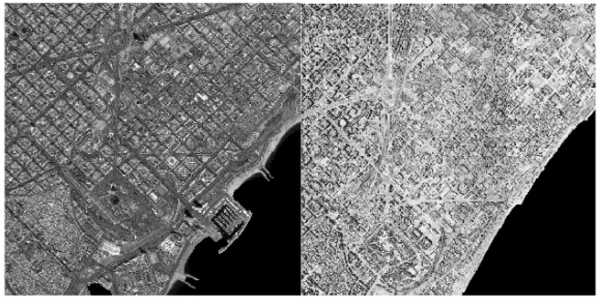
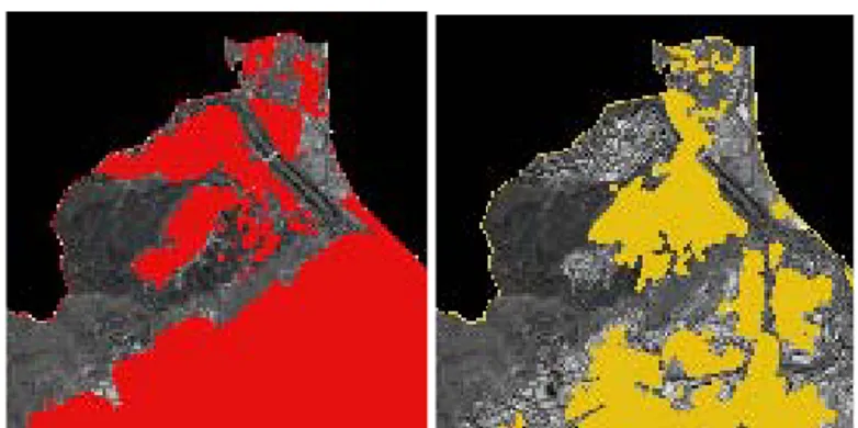
Study area Barcelona The physical limits of Barcelona extend to almost 100 Km2. and the city had a population of some 1,595,110 inhabitants in January 2007 leading to a population density of almost 16,000 inhabitants / Km2 [4]. Two data sets were used for the study. One is subset of an SPOT5 scene, recorded on 2005. It is a fusion product of the panchromatic band (10m spatial resolution), following the homogeneity of urban settlement complexity high imagery resolution will not give a good results through mathematical morphology process. The second data set is from an airborne (black and white photographs), acquired on 1956, average resolution of 32cm spatial resolution, after test reduce pixel size process already done to obtain 10m resolution for both datasets (see Figure 1.2).Data Pre-Processing The analysis of multitemporal/multisensoral remote sensing data sets can only be efficiently done if the data present itself in a common geometry. Geocoding of the images therefore has to meet extremely strict requirements if the data obtained at different acquisition dates with different systems are processed multitemporally in one "data stack". Geocoding of the individual images of such a data set to the geometry of a topographic map is the most common procedure to accomplish comparability. However, Due to the lack of GIS data and digital elevation model, Ortho‐rectification for the pair of images could not be achieved. Image‐to‐image registration has been carried out so that an identical image coordinate system could be established for assessment. The overall registration error with 160 reference points was less than 2 pixels. Visual Interpretation A visual interpretation of remote sensing data means not to overlay transparencies on images, in the way, how conventional airborne photographs were interpreted in former days. In present days the digital images are mapped by screen digitizing. In spite of the digital image the interpretation technique is similar to the conventional airborne analogue photograph interpretation. The advantage of computer aided visual interpretation with geocoded airborne photographs (digital aerial maps) is the availability of rectified thematic maps. These can be integrated into a GIS based system and can be combined with computer‐aided classification of settlement structures. The quality of visual interpretation is connected with the skills of the interpreter. The more the interpreter knows about the landscape that is investigated the more information will be generated. The general advantage of a conventional visual interpretation is the high accuracy of the results. The pair of SPOT images and Arial Photographs was first imported into ESRI ArcGIS 9.0 for digitizing the boundary of the artificial areas. After completing image digitization, the GIS polygon layer representing the urban zones of the above municipalities in 2005 was clipped by the one of 1956. The resulting GIS polygon layer thus represents the change areas. The areas of these zones were calculated for assessing the quality of the other image texture analysis and classification approaches later. The drawback of this methodology is the labour intense and time‐ consumption, which may take hours for the entire digitization process. Figure 1.3 demonstrates the limits of visual settlement structure interpretation with conventional aerial map.
8
Fig. 1.3 digitized images for year 2005 (left) and 1956 (right).
Urban History (past and future of Barcelona)
Fig. 1.4 ( left) year 1600 (middle) year 1859 (right) year 2004
interpretation on figure 1.4 explains more the situation through different years in Barcelona and its growing. The main core if the city Is clearly visibible in all the three maps. The most important overall is the composition of the new part of Barcelona with the Blocks Cerda ( see image 1.5) Fig. 1.5 Cerda Blocks Barcelona's urban extension, the Eixample Cerdà, is a vivid illustration of the intense reflection on the shape of cities that took place during the nineteenth century and that characterised a city planning that arose from an urgent need for solutions to an environmental and social urban crisis. Extreme conditions of urban crowding, the result of rapid city growth, and insalubrious housing and public places were indeed seen as the prime cause of the soaring death rate that marked the vital and statistical perception of urban spaces and was undoubtedly the city's biggest problem. Galenic medicine and the incipient town planning both explained the increased risks to health, which took the form of high death rates in the city, as the result of the overcrowding that characterised the city at the time, on the basis of a range of evidence: from the exponential increase of the population inside the walled area to the intensive subdivision of property, which gave rise to ever smaller units of living accommodation.
10 This link between density and high death rate was studied from a positivist outlook on the basis of an exhaustive compilation of data, whose analysis let to the conclusion that there was a need to reform and enlarge the existing city as a prior condition for planning an urban space suited to the technical ideal of public health. In the case of Barcelona, this causal analysis of density and mortality, which along with many other statistical data was gathered in Teoría general de la urbanización, provided Ildefons Cerdà with his justification of the need for the Pla de l'Eixample, the extension plan whose 150th anniversary we are celebrating in 2009. This monographic dossier takes this historical perspective as its starting point and puts forward four main arguments related to Cerdà's Eixample and its legacy in the city of Barcelona. First of all, a contextualisation of the Pla de l'Eixample as an urban process in which we need to consider the legacies and the dynamics of the point of departure, not only with regard to urban land in the strict sense, but, above all, in relation to social and political aspects that shaped the process of urbanisation. The articles by Ramon Grau, Marina López and Manual Guàrdia explore these issues in depth and help us understand the complexity accompanying the morphological and functional changes in the nineteenth‐century city. This complexity indicates that it was not just the city's physical space, its walls and public places, that changed, but also the urban society itself. This presentation of the evolution of the Pla de l'Eixample, rather than looking on it as a brilliant plan that was subsequently transformed or corrupted by the planning process, actually approaches it from precisely the opposite viewpoint. That is, the Eixample in fact becomes the board on which the city and its planning have played out an unbroken dialogue with the project and its results. It is certainly true that the building process in the Eixample was guided by different criteria to the ones underlying the original proposals, as we see in the progressively increasing density of the blocks of houses and of the built‐up fabric, which has already been well studied and is well known. But it is no less true that Cerdà himself introduced modifications in his proposals, always aiming at the maximum pragmatism according to the moment in history, and that the gradual changes involved the introduction of elements and situations that are now looked on favourably. The articles by Joaquim Sabaté, Mercè Tatjer and Joan Roca look at this fascinating debate and show to what extent the Pla de l'Eixample lets us reflect, not only on the city that was, but also on today's. The emphasis on the relationship between the management of the Pla de l'Eixample and planning practice in Barcelona takes on special interest when it comes to evaluating the city's recent past. In this respect, the articles by Joan Busquets, Maria Buhigas and Salvador Rueda
present a comprehensive view of the democratic town‐planning that laid a new foundation for urban management in the city and, with an eye on the present moment, a century and a half after the plan was approved, reveal the immense capacity of the Eixample as an urban form capable of housing different city functions, adapt to new usage programmes and even represent new social perceptions. Finally, the 'Proposals/answers' section of this monograph proposes a reflection on the future of the Barcelona metropolis in the twenty‐ first century starting from the long‐range outlook that was a feature of Cerdà's reflection on nineteenth‐century Barcelona. The articles by Juan Antonio Mòdenes, Manuel Gausa and Jordi Pascual, therefore, tackle the question of the physical and social morphology of the future metropolis and reveal the contradiction involved today in the fact that metropolitan dynamics show a clearly regional magnitude while local government powers are still not effective at a supra‐municipal level. These three articles, with different arguments and varied points of view, look at what in demography, town‐planning and culture is the main challenge facing metropolitan regions at this moment, including the case of Barcelona. We know the metropolitan area well enough, we make fairly accurate assessments of population sizes, land consumption and cultural habits, but we have yet to face the problem of how to put this exhaustive diagnosis at the service of an all‐round view of regional government, capable of giving content to new forms of metropolitan management more closely suited to the regional dimension urban issues are taking on at the present moment. The situation does in fact bring to mind the one in which Cerdà proposed the Pla de l'Eixample, because after compiling detailed statistics and completing the diagnosis of the main urban problem at that time ‐ the high urban death rate associated with crowding ‐, the reflection introducing the Eixample led to none other than the municipal aggregation of 1898, which was, in fact, a first jump in the scale of city government. At the present moment, any thought of this sort of fitting regional government to a vast metropolitan scale raises not a few difficulties; but even so it is a necessary condition and not sufficient in itself. In other words, the possible creation of a future metropolitan government or law would have to be accompanied by another even more important measure clearly rooted in Cerdà: the redefinition of urban policies, inspired in a regional diagnosis, to adapt them to the true dimension of the issues that make the metropolis what it is. Regionalising urban policies: this is the 'Cerdà measure' Barcelona can take advantage of in the new century.
12 Cerdà's rhetorical demand to 'countrify the urban, urbanise the countryside' has probably been fulfilled in the course of the twentieth century, and indeed we have urbanised the countryside though it is equally clear that we have done so without politics, without policies to inspire urbanity beyond mere urbanisation of the land. Beyond the celebration of the date and the tribute to the figure of the engineer who created the Eixample, Cerdà Year has been an opportunity to submit these questions to debate. A debate which, though it must start with the Eixample itself, with an assessment of its history and its urban significance at the present moment, must end far from the borders defined by the geometry of its grid system and show up the areas of the metropolis where the 'Cerdà move' is most needed today.
Existing Situation
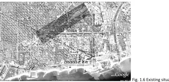
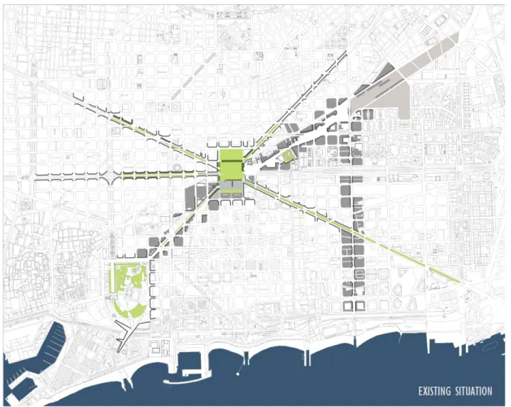
Concerning the intension of the thesis in the figure 1.6 there is a clear explanation of the existing situation in accordance with the indication of the area for a new master plan proposal. The area with a darker square indicates the connection between the main core of the city which is Glories and the new transformed part on Sagrera Station. In the mentioned area there is a need for a new Mirador (meaning of which is explained in the next sheet). 8 8 12
Fig. 1.6 Existing situation in Barcelona
Mirador meaning , Why Mirador
Mirador is an object which can be observed and easily recognizes. It is a node in the city and it symbolizes a landmark or a new reference point in a area. Mirador is also a place from which we can observe the city in the best possible way.
14 The reason to create a Mirador in City of Barcelona is very simple. First of all Barcelona is a city of connections and special landmarks all over the public spaces, starting from the old parts of the city towards the new extensions and urban transformations. Concerning that the area chosen to be developed is supposed to be very frequent and important. A creation of a new Mirador in this situation will create a new node in the city and reconnect all the other important nodes. Another symbol or reason or inspirational point of view to creation of a new Mirador comes out of the main core around the public areas allover Barcelona. As a visitor and pedestrian in Barcelona there is a possibility to observe different sculptures all around important public spaces. Some images in figure 1.7 are to demonstrate this in a better way. Fig. 1.7 some sculptures in Barcelona
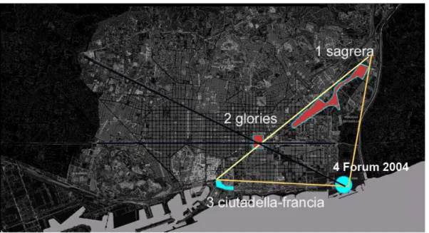
Fig. 1.8 the triangle
Urban Transformations
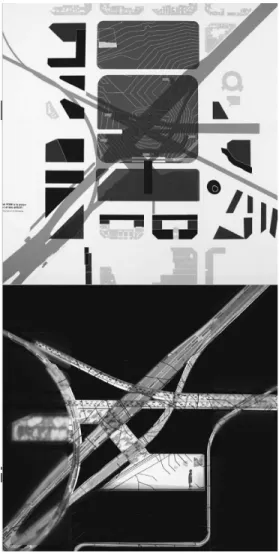
Considering that the main analytic approach towards this thesis is the Urban Transformations in the drawing 1.8 there is clearly explained the intension of analyzes al over the most important nodes in Barcelona. The green areas overall are somehow creating new paths of public spaces and they are considered to be used more in between the most important Streets. Moreover the black lines are referred as virtual borders for composing an intentional area while designing. As a complete explanation concerning this drawing diagram, there is clearly an intension of connections all around Barcelona, with a special attention towards the core of Glories which is referred as a reference point and a midpoint connectivity with Cittudella Park , Sagrera and the sea side from both the nodes. In Sagrera there is strictly Perpendicular Street supposed to create a new corridor for the connection with the sea side. The system obviously works as connectivity to the whole city of Barcelona .16
Urban transformations and analyzes Glories
Fig. 2.0 urban transformations in Glories
18 The next step of analyzes is about Glories and the intension of urban transformations. In the figure 2.0 there is clearly explained the triangular concept of the main connections with Sagrera new train Station and Forum 2004. The actual urban transformation in Glories according to municipality consists a huge public green area. Moreover in the figure 2.1 there are shown some buildings which have been considered as important once. Fig. 2.1 Glories surrounding
Fig. 2.2 urban sections in Glories
Urban sections explain properly the existing situatin in accordance with the glories transformation and new projects . Moreover the figure 2.3 explains the underground system .
20
Fig. 2.4 Glories municipality master Plan
22
Urban transformations and analyzes Sagrera
Fig. 2.5 Urban Transformations in Sagrera
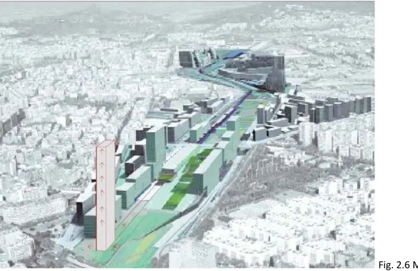
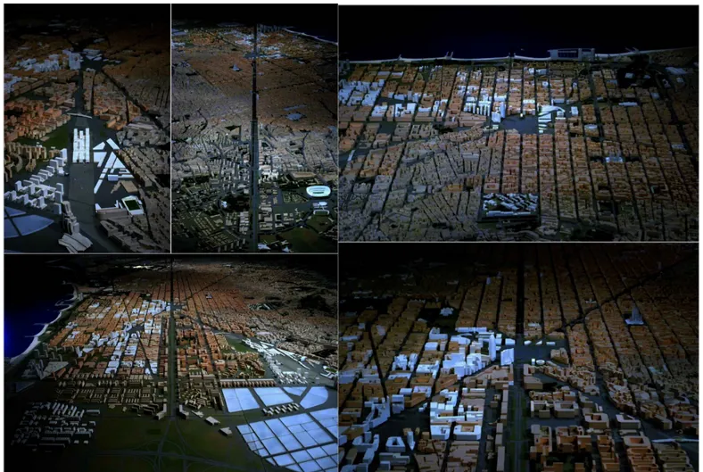
Now there are specific analyzes concerning Sagrera station which more or less is the main intension of the thesis. Clearly in the photo montage of the municipality master plan and the visual conceptual symbolic form of a new mirrador there is a main concept of the reasoning to use this part of the master plan for building.
24
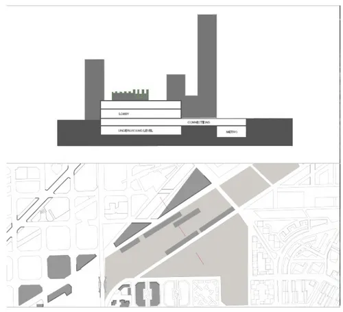
Fig. 2.8 The Sagrera Master plan and section
26
Analyzes Summary
Analyzes previously mentioned explain to us the urban transformations step by step, in this way after we are well informed we can consider to do changes and new proposals in Barcelona. As a conclusion the areas to be considered in Particular are about to begin and the solution will be a new concept always in combination with the municipality proposal. Even though municipality proposal is concentrating more in the organization of public spaces and organizing different flows op people, cars and trains, there should be much more happening in this very important node.28
Master Plan
Composition of the Master Plan
Barcelona is a city in Progress. Traditionaly Placa de les Glories was physical and geometrical centre between the popular and suburban district: El Clot, la Lacuna. Poblenou, Fort Plus and Sagrada Famiglia. The horizon of Glories is rapidly changing. Barcelona in the east is based on three new centers: Glories, Sagrera and Forum, forming an eastern triangle that structuralizes the new economy area of the city. The Glories square becomes the Urban connection centre between Sagrera station and Citudella Park. It is defined as a group of spaces that includes leisure and culture, economies and administrative activities, and road and transportation infrastructures. Infrastructural system is changing as well. High velocity trains are going to bypass along the underground straight tunnel connecting Sagrera and Saints. For this reason municipality decides to demolish and change Placa de les Glories urban structure, but there is e new proposal concerning the one from the municipality. Moreover it is more concentrated on cultural public areas.
Final Approach towards Master Plan
Especially in Barcelona the mobility system is realized into different levels and has important ‘interfaces’ in the city (port, airport, railway station…), each characterized by different categories of users. For this motive the last part of the communication is oriented to describe Barcelona and our project area at different scales and through the different points of view, in order to organize, with the help of different analysis and surveys, the data that we need to proceed. Certainly they have to be completed by visiting the site, to add new important informations and to increase the knowledge that we have obtained by morphological and typological analysis. Combining the two ‘data’ (the data obtained through the study of maps and the informations elaborated by the visit of the site) we have improved our knowledge of the area. Overall we have known the different elements that composed it and their connections. It doesn’t remain any other thing to proceed. We are tracing out a new language in the perception and in the domination of a new urban scale. In the history it isn’t surely the first time. The consolidated stages in the different periods, that nowadays we recognize in the dynamic envelopment of the growth of urban organism, they have every time been the answer to necessities by the abilities of the time. For somebody «architecture» is the answer to a necessity, or particularly to a problem. The space that in our mind is conceived as baroque space, nowadays appears as the obvious and manifest answer of that historical‐social situation.
30
Glories area
Glories master plan
To design a public space means to work with different elements: flows, infrastructures, landscape, natural elements, urban furnitures. A public
space project is also a landscape project. It concerns the ground level and so it has to define characters of soil. For that reason it’s important to start from some theoretical issues: meaning of public space in contemporary urban context but also in contemporary culture (everything is lansdcape), relationship between landscape and urban project, space and time.
34
36 Barcelona Sants‐Sagrera high‐speed tunnel Project benefits Building the Sants‐La Sagrera tunnel represents one of the main milestones in the development of the Madrid‐Barcelona‐French Border High‐ Speed Line, which will allow Spain to join the future trans‐european high‐speed rail system in 2012, and to that which continues advancing towards the French border. It is an important element of territorial structure. In addition, it will improve the railway communication network between the three Catalan provinces, and from them to the rest of Spain and Europe. The tunnel will also improve the remaining railway services, as the other tunnels in Barcelona will be freed from the medium to large distance traffic that will now run through the new tunnel, once it is operative.
Its construction will also generate new socioeconomic development areas and new urban transformation and expansion opportunities thanks to the execution of the new La Sagrera station, which will be able to receive 100 million passengers each year. Barcelona will enjoy the privilege of having two high‐speed stations connected, giving passengers the chance to choose from Barcelona Sants or La Sagrera as their departure or arrival high‐speed station in the capital. Characteristics of the Tunnel: The Sants‐La Sagrera double track tunnel has a section of 85 m2 and a length of 5.6 km that go from the Barcelona Sants station to the future La Sagrera terminal. The excavasion will be mainly made with a tunnel boring machine, which will advance from la Sagrera to Sants through the middle of Mallorca, Diagonal and Provença streets, reaching an approximate perforation depth of 41 m without having to pass under any buildings at any time, until the extraction point located between the streets of Provença and Entença.
38 The Tunnel Boring Machine “Barcino” The tunnel boring machine with the Latin name for Barcelona “Barcino”, is 105 metres long and weighs 2,300 tonnes. It will bore a distance of 5.1 km out of the 5.6 km of the tunnel’s length and the tunnel's interior diameter will be 10.4 metres. It is of the EPB type (Earth Pressure Balance Shield), which is the safest method in urban areas. During the excavasion, the tunnel boring machine does not alter the original conditions of the ground in front, and as it advances it places the voussirs, reinforced concrete blocks that make up the tunnel’s coating. Safety For Adif and the Spanish Ministry of Publick Works and Transport, safety is the highest priority when executing their works, therefore a comprehensive auscultation and control plan has been fulfilled, which, together with the execution of protection treatments, will allow for the safety and integrity of the ground and nearby buildings. During the construction process different safety controls are carried out using instrumental devices, as well as daily measurements made by specialised technicians, and computer‐processing of all data. So far, more than 2,600 auscultation elements have been installed. As the tunnel boring machine advances, these sensors will be increased to approximately 7,000. Likewise, the safest construction methods are adopted in order to guarantee safety of the works and especially of the structures’ ground. In this sense, perforation with the tunnel boring machine is the process that offers more benefits in the excavation of urban tunnels, and for the excavation of screens the hydro milling machine system is used, which minimises impact on the ground.
Protection of special buildings In the construction of this tunnel, Adif is developing complex civik engineering actions that allow for the preservation of Barcelona’s cultural and architetural heritage.
40 One of these actions developed around the Torre del Fang, one of Barcelona’s historic buildings which dates back to the 14th Century. The technical solution consisted in the maintenance of the structure with a special support while the screens, piles and micropiles, the construction of the cover‐slab and the excavation were being carried out. On the other hand, before the tunnel boring machine begins to operate, due to the special structure of the Sagrada Familia, a specific protection has been set up by means of a permeable screen with piles having a diameter of 1.5 metres and a depth of 40 metres. In addition, a longitudinal concrete dice of 3x3 metres will be built next to the screen, and the ground will be improved by means of consolidation injections. In a like manner, the ground of the area where the La Pedrera building is located is being checked in order to determine whether it is necessary or not to also take protection measures of Antonio Gaudi's special works. Work starts on the new La Sagrera station posted 21/06/2010 at 20:29 h. Sonia Doctor "Today is a historic day for Barcelona". This was how Jordi Hereu described last Monday, the day that marked the start of work on the new La Sagrera station. The most important railway project in Europe and the biggest underground main line railway project in any European country, it is set to become the high‐speed gateway to and from Europe. A great infrastructure, according the Mayor, that will become "an irrevocable step" towards "realising the old dream of a new centrality" for northern Barcelona.
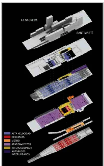
Work on the future La Sagrera station is already underway. What is set to become the high‐speed gateway to Europe is becoming a reality. As he presided over led the ceremony signalling the start of the work, accompanied by Spain's Minister for Public Works, José Blanco, and President of the Generalitat [regional government] of Catalonia, José Montilla, the Mayor Jordi Hereu described that Monday as "a historic day for the city of Barcelona". The new intermodal station is the country's most important railway project, both in the size of its investment, nearly 590 million euros, and in its physical scale, covering over 295,000 square metres. Connecting neighbourhoods The work will cover 38 hectares of railway line, making it the biggest underground railway project in the whole of present‐day Europe. The operation will reconnect neighbourhoods separated by train lines along a four kilometre stretch, between Carrer Espronceda and Nus de la Trinitat. Spain's Minister for Public Works, José Blanco, insisted the new station would promote the redevelopment of the Sant Andreu‐Sagrera area, describing the project as "one of the most ambitious" in the last eighteen years since the 1992 Olympic Games. The Mayor called the new station "an irrevocable step in building northern Barcelona and realising the old dream of a new centrality". Hereu championed the use of major infrastructure projects "for city‐building", insisting such work would mean "progress, connected neighbourhoods, new protected housing and more green areas" for all residents in the Sant Andreu district. Strategic metropolitan hub La Sagrera station is expected to receive an estimated 100 million users per year. This will make it a strategic hub for the Metropolitan area public transport network and will serve to give the city faster connections with the rest of Spain and Europe.
42 This intermodal station will be used by high speed trains together with local and regional railway networks, the Metro, city and inter‐city buses and coaches, taxis and private vehicles. The station will be built to comply with energy efficient and sustainable criteria and all levels will be accessible to people with reduced mobility.