SCUOLA DOTTORALE IN
GEOLOGIA DELL'AMBIENTE E DELLE RISORSE (SDiGAR)
XVII CICLO
Surface deformation and magma intrusion
along divergent plate boundaries
Dottorando:
__________________
Daniele Trippanera
firma
Docente Guida:
__________________
Valerio Acocella
firma
Coordinatore:
__________________
Claudio Faccenna
firma
Co-Tutor:
Dr. Joel Ruch: ricercatore presso King Abdullah University of Science and Technology (KAUST), Thuwal, Saudi Arabia.
Revisori:
Dott. Marco Neri: primo ricercatore presso l’Istituto Nazionale di Geofisica e Vulcanologia, Osservatorio Etneo, Sezione di Catania, Unità Funzionale Gravimetria e Magnetismo.
Dott.ssa Eleonora Rivalta: PI of an ERC Starting grant research group, project CCMP-POMPEI presso il GeoForschungsZentrum GFZ German Research Centre for Geosciences.
Commissari:
Prof.ssa Maria Rita Palombo: professore Associato SSD GEO/01 Dipartimento di Scienze della Terra Università Roma la Sapienza.
Prof. Orlando Vaselli: professore Associato SSD GEO/08 Dipartimento di Scienze della Terra Università di Firenze.
Dott. Marco Bonini: professore Associato SSD GEO/03, ricercatore CNR, Istituto di Geoscienze e Georisorse Dipartimento di Scienze della Terra, Università di Firenze.
Table of Contents
Abstract (in English) ... 1
Riassunto (in Italian) ... 2
Introduction ... 4
1.2 Methods ... 5
1.2.1 Field surveys ... 5
1.2.2 Analogue models ... 8
Chapter 2: Surface deformation along the divergent plate boundaries: understanding magmatic vs. tectonic processes ... 11 Abstract ... 11 1. Introduction ... 12 2. Tectonic setting ... 14 3. Methods ... 16 4. Results ... 17 4.1. Eruptive fissures ... 17 4.1.1 Lakagigar ... 17 4.1.2 Eldgjá ... 18 4.1.3 Bardarbunga ... 19 4.1.4 Sveinagja ... 20 4.1.5 Sveinar ... 21 4.2. Rift segments ... 21
4.2.1 The Krafla magmatic system ... 21
4.2.2 Vogar rift zone ... 23
4.2.3 Thingvellir rift zone ... 24
4.2.4 Fantale magmatic system ... 24
5. Discussion ... 25
5.1. Interpreting the collected data ... 25
5.2. A general model ... 30
6. Conclusions ... 32
References ... 33
Figure and tables ... 39
Chapter 3: Experiments of dike-induced deformation: an application to divergent plate boundaries ... 57
Abstract ... 57
1. Introduction ... 58
2.1. Setup and methods... 59
2.2. Scaling and materials ... 61
2.3. Assumptions and limitations ... 62
3. Results ... 63
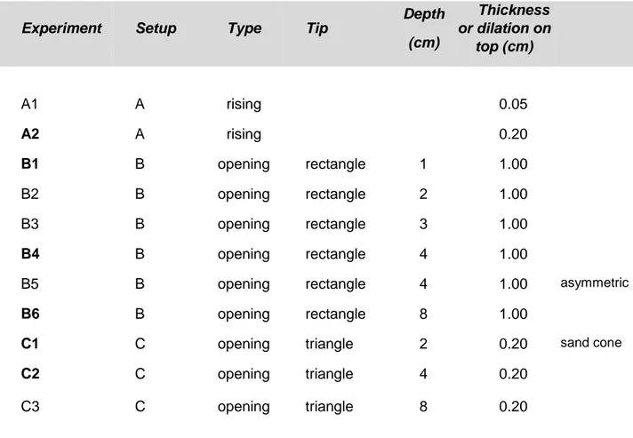
3.1. Setup A: upward propagating intrusions. Experiment A2 ... 63
3.2. Setup B and C: thickening intrusions at constant depth ... 64
3.2.1 Experiment B1: shallow rectangular intrusive complex ... 64
3.2.2 Experiment B4: medium depth rectangular intrusive complex ... 66
3.2.3 Experiment B6: deep rectangular intrusive complex ... 67
3.2.4 Experiment C1: shallow triangular intrusive complex ... 68
3.2.5 Experiment C2: medium depth triangular intrusive complex ... 69
4. Discussions ... 69
4.1. Overall deformation pattern and setup relevance ... 69
4.2. Effect of the intrusions depth and geometry on the deformation... 72
4.3. Fault propagation ... 73
4.3.1 Normal faulting ... 73
4.3.2 Arcuate normal/reverse faults ... 74
4.4. Comparison to rift zones ... 75
4.4.1 Single rifting episodes ... 76
4.4.2 Multiple rifting episodes ... 77
4.4.3 Intrusion depth vs. thickness ... 79
5. Conclusions ... 81
References ... 82
Figure and tables ... 87
Chapter 4: Experiments of dike-induced deformation: an application to divergent plate boundaries ... 105
Abstract ... 105
1. Introduction ... 105
2. Field analysis ... 105
3. Analogue models ... 107
4. Discussion and conclusions... 109
References ... 110
1
Abstract
The interest in the role of magma in splitting plates at divergent plate boundaries has been recently re-enhanced. However, the peculiar mechanism by which the magma affects the geometry, the kinematics, and the temporal evolution of a rift is still poorly understood, especially in a long time perspective. Moreover, it is also necessary to better define how and to what extend the regional tectonics - by means of plate pull mechanism - affects the rift structures formation along these margins. The aim of this work is to address these issues through field survey and analogue modeling.
Field survey consists of studying the surface deformation along different fissural portions of the magmatic systems at the Neovolcanic Zone of Iceland and the Main Ethiopian Rift, focusing mainly on: 1) single eruptive fissures (Laki, Eldgjá and Bardarbunga in Iceland) or narrow fissure zones hosting recent eruptive fissures (i.e., Sveinagjá and Sveinar in Iceland), 2) wider fissure zones where several rifting episodes occurred (i.e. Krafla, Vogar and Thingvellir in Iceland and Fantale in Ethiopia). In all these areas, fault and extension fracture geometries and kinematics have been systematically characterized, including the analysis of the structure of the fault’s lateral terminations, conceived as possible indicators of their propagation direction.
In addition, these data have been integrated with the study of the roots (depth of about 1.5 km) of the fossil Alftafjordur magmatic system (Eastern Iceland).
Analogue models have been used to test the effect of repeated dike intrusions at the surface, characterizing the geometry and the kinematics of dike-induced structures. In order to quantify and reconstruct the temporal evolution of the surface deformation, laser-scanner and Particle Image Velocimetry (PIV) techniques have been applied to the models.
Field analysis show that at the surface, the eruptive fissures are bounded by normal faults forming a graben, thus suggesting a clear relationship between diking and surface deformation. Grabens, normal faults and extension fractures also characterize the surface of wider fissure zones. The faults usually exhibit an open structure, with locally tilted hanging wall and possible contraction at its base. However, the study of the fissure zones roots reveals that at depth the extension is accommodated by dikes, with almost no faulting.
Analogue models results show that a graben forms above a dike complex gradually thickening at depth, whose structures geometry and kinematic depend on ratio between the intrusion depth and its cumulative thickness. This suggests, again, that diking may play a fundamental role in rift formation.
2 Models and nature share several common features (i.e., graben with downward propagating normal faults, contraction at the base of the tilted hanging wall, subsidence above the dike complex and uplift to its sides), suggesting that most deformation along divergent plate boundaries may be acquired through repeated dike injection, requiring no direct tectonic contribution. However, the extension due to the regional tectonics remains still important for the long-term evolution of a divergent plate boundary: on one hand, it provides the required conditions for the rise and focusing of magma along the axial zone of the margin, on the other, it enhances the fault activity in more distal areas from the axial zones and during the inter-rifting periods.
Riassunto
L’interesse rispetto al ruolo del magma nella separazione delle placche lungo i margini divergenti si è recentemente rinvigorito. Tuttavia, il meccanismo preciso con il quale il magma influenza la geometria, la cinematica e l’evoluzione temporale di un rift è ancora poco chiaro, soprattutto nel lungo termine. Inoltre, resta da definire quanto e come la tettonica regionale, attraverso il meccanismo di plate pull, influisce nella formazione delle strutture di rift lungo tali margini. Questo lavoro ha lo scopo di far luce su tali problematiche, attraverso analisi di terreno e modellazione analogica.
L’analisi di terreno comprende lo studio della deformazione in superficie lungo diverse porzioni fissurali dei sistemi magmatici della Neovolcanic Zone in Islanda e del Main Ethiopian Rift, in particolare focalizzandosi su: 1) singole fessure eruttive (Laki, Eldgjá e Bardarbunga in Islanda) o strette zone fissurali che ospitano recenti fessure eruttive (Sveinagjá e Sveinar in Islanda), 2) ampie zone fissurali dove sono avvenuti numerosi episodi di rifting (Krafla, Vogar e Thingvellir in Islanda e Fantale in Etiopia). In queste aree, la geometria e la cinematica di faglie e fratture estensionali sono state caratterizzate in maniera sistematica, includendo l’analisi della struttura delle terminazioni laterali delle faglie come possibile indicatore del loro senso di propagazione.
Inoltre, tali analisi sono state integrate con lo studio delle radici (paleo-profondità di circa 1.5 km) del sistema magmatico fossile di Alftafjordur (Islanda orientale).
Attraverso i modelli analogici, invece, si è testato l’effetto dell’intrusione ripetuta di dicchi sulla superficie, caratterizzando la geometria e la cinematica delle strutture da essi indotte. Per quantificare la deformazione e ricostruirne l’evoluzione nel tempo sono state applicate ai modelli lo scansionatore laser e la tecnica di Particle Image Velocimetry (PIV).
3 Le analisi di terreno mostrano che in superficie le fessure eruttive sono bordate da faglie normali che formano un graben, suggerendo così una chiara relazione tra dicchi e deformazione in superficie. Graben, faglie normali e fratture estensionali caratterizzano anche la superficie delle zone fissurali più ampie e mature dove più episodi di rifting sono avvenuti. Le faglie mostrano generalmente una struttura aperta, con il tetto della faglia localmente basculato e con la possibile presenza di contrazione alla sua base. Tuttavia, lo studio delle radici dei rift rivela che in profondità l’estensione è accomodata quasi esclusivamente da dicchi, con una ridotta fagliazione.
I risultati dei modelli analogici mostrano che al di sopra di un complesso di dicchi che si inspessisce gradualmente, si ha la formazione di un graben, le cui geometria e cinematica delle strutture interne dipendono dal rapporto tra la profondità di intrusione ed il suo spessore cumulato. Questo suggerisce, ancora una volta, che l’intrusione di dicchi può avere un effetto diretto sulla superficie e quindi un ruolo fondamentale nella formazione dei rift.
Modelli e natura mostrano molte caratteristiche comuni (ad es.: graben con faglie normali che si propagano verso il basso, contrazione alla base del tetto di faglia basculato, subsidenza al di sopra del complesso di dicchi e sollevamento ai suoi lati), suggerendo che la maggior parte della deformazione lungo i margini divergenti di placca può essere acquisita attraverso ripetute iniezioni di dicchi, non richiedendo un contributo diretto della tettonica regionale. L’estensione dovuta alla tettonica regionale rimane tuttavia importante per l’evoluzione a lungo termine di un margine divergente, sia perché essa fornisce le condizioni necessarie per la risalita e la focalizzazione del magma lungo la zona assiale del margine, sia perché promuove l’attività di fagliazione nelle aree più distali dalle zone assiali e durante i periodi di inter-rifting.
4
1. Introduction
Most seismic and volcanic activity on Earth is present along the divergent plate boundaries. A peculiar aspect concerning these boundaries provides a definition of the mechanism which characterizes the separation process of plates. According to traditional theories, the phenomenon of separation occurs through tectonic processes at large scale (i.e., plates pull), linked to extensional faults’ activity. However, the recent rifting episodes which occurred in the last decades, highlighted the crucial role the magma can play in shaping the divergent boundaries. These episodes occurred in the oceanic, as well as in the continental and transitional crusts, allowing to undertake an accurate research on surface deformation directly inducted by magma emplacement, through dikes intrusion. In particular, geodetic measurements (mainly InSAR and GPS) show that during intrusive episodes a characteristic deformation occurs at the surface. It is composed of a narrow (few km large) strip above the dike/dikes that is subject to subsidence, while an uplift occurs at both sides; both subsidence and uplift may reach up to few meters [i.e., Rubin, 1992; Sigmundsson, 2006; Wright et al., 2006]. Moreover, perpendicularly to the dike, a relevant horizontal opening occurs, up to several meters [i.e., Wright et al., 2006; Biggs et al., 2009]. Such a deformation is also obtained by means of numerical and analytical modeling of a dike that opens at depth [i.e. Dieterich and Decker, 1975; Mastin and Pollard, 1988; Rubin and Pollard, 1988; Rubin, 1992; Dvorak and Dzurisin, 1997]. Observations in the field prove that, together with these kind of episodes or intrusive events, several fractures generate at the surface. This phenomenon is also associated with the formation or re-activation of normal faults (with metric throws), generating a graben centered and parallel respect to the dike/dikes [i.e., Bjornsson, 1977; Acocella and Neri, 2003; Rowland et al., 2007; Pallister et al., 2010]. Moreover, the generation of these grabens with inward dipping normal faults, related to dike propagations, has been also demonstrated through analytical, numerical and analogue models [Mastin and Pollard, 1988; Rubin and Pollard; 1988; Rubin, 1992; Gudmundsson, 2003; Gudmundsson, 2005].
Thus, all these observations have newly enhanced the interest towards divergent plate boundaries, reopening the whole question on traditional theories regarding plates’ separation process.
In particular, it has been observed that the opening during rifting episodes can reach some meters of width across a short time period (less than few tens of years). These rates are definitely abundant in comparison with regional extension rate, which is at the size of mm/yr normally. Such evidences clearly show that in the short time period magma plays a
5 primary role in generating rift structures and extensional processes in general, by means of episodic and rapid dike intrusions. On the contrary, regional tectonic seems to play a very restricted role [Sigmundsson, 2006; Wright et al., 2006; Ayele et al., 2007; Ebinger et al., 2010]. However, data directly concerning the effect of the magma intrusion along divergent boundaries is limited to the last decades. Therefore, the relative influence of magma and tectonics in controlling the whole extensional processes and the formation of rift structures along divergent boundaries is still under debate, especially on a longer term view.
1.2 Methods
In order to better investigate on the arguments previously introduced, two different methods have been applied: field survey and analogue modeling.
1.2.1 Field surveys
Rift generation along divergent plate boundaries occurs both in continental crust (where the separation process among plates is at its first stage) and oceanic crust (where the process is at its advanced level). One of the most representative divergent plate boundary in the continental crust is the East African Rift System (EARS), which develops from Afar depression to Monzambique, separating the Nubia plate (to the West) from the Somalia plate (to the East) with an extension rate of 4-7 mm/yr [DeMets et al., 2010, and references therein]. In particular, in this work, a field survey has been carried out in the portion of the EARS coinciding with the Main Ethiopian Rift (MER), representing an excellent site for investigating on the present structure of a continental rift.
Divergent plate boundaries at their mature stage are mainly associated with oceanic ridges. In particular, this work focuses on the Middle Atlantic Ridge (MAR). The most accessible portion of MAR geographically corresponds to Iceland, where the ridge arises at the surface. Here, the active portion of the ridge is several tens of kilometres wide and separates the North American plate (to the West) from the Eurasian one (to the Est), with a rate of ~2 cm/yr [DeMets et al., 2010, and references therein].
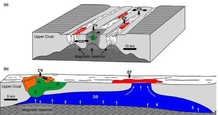
The axial active zones of the divergent boundaries are characterized by the presence of several magmatic systems (20-100 km long), which are their fundamental elements. Magmatic systems are composed of a polygenic central volcano, generally with a summit caldera, and a relevant fissural zone, characterized by open normal faults, extensional fractures, eruptive fissures and monogenic aligned cones [Fig. 1; Einarsson e Saemundsson, 1987; Gudmundsson, 1987, 1995, 2000]. At depth, they are mainly formed by two types of dike swarms: local, limited to the area involving the central volcano, and
6 regional, which spread outside the area of the volcano and are parallel to the fissural zone of the system. Local dikes are characterized by circular shapes, depending on the stress of the volcanic structure and its magmatic chamber [Gudmundsson, 1995; Tibaldi, 2008], while regional dikes concentrate mostly in swarms 5-10 km wide and ~ 50 km long, whose direction is mainly dependent on regional stress [i.e., Walker, 1959; 1960; Gudmundsson, 1995; Paquet et al., 2007].
The field surveys carried out in this work aim at analyzing the fissural portions of different magmatic systems distinguishing two main domains. The first is related to simple eruptive fissures with a narrow deformation zone (hundreds of m wide, as Eldgjá, Laki, Sveinagja, Sveinar and Bardarbunga, in Iceland), related to one or very few diking events. Since the eruptive fissures are generated by feeder dikes, the study of geometry and kinematics of deformation pattern associated with them is focused on understanding the direct impact of the magma on the surface deformation, with a negligible contribute of the regional tectonics. In particular, the eruptive fissures of Edgjà (933-941 A.C.) and Lakagigar, (1783-1784) are the two greatest rifting episodes in Iceland history, with an eruptive volume of 18.3 km3 and 14.7 km3 [Thordarson et al., 1993; Thordarson, et al., 2001]. The Svenagià and Sveinar grabens have been recently reactivated by a rifting episode (1875), associated with a relevant caldera collapse of the Askja central volcano [i.e., Gudmundsson and Backstrom, 1991] and are characterized by a narrow deformed zone (<1.5 km). Indeed, the most recent Bardarbunga rifting episode started back in August 2014 and still on-going: it represents a unique opportunity for investigating on deformation related to active dike intrusions. This event is also one of the biggest occurred in Iceland across the last 100 years and may be directly compared with the oldest Edgjá and Lakagigar fissures.
The second domain concerns the geometric and kinematics investigation of grabens, normal faults and extensional fractures, characterizing more complex and mature rift segment, hosting several eruptive fissures within a broader deformed area (several km wide, as Krafla, Vogar, Thingvellir in Iceland and Fantale in Ethiopia) and in which magma and tectonic induced structures may be mixed. In particular, the fissural areas of the Krafla magmatic system is well known for a recent rifting episode, during which ~20 dike intrusions occurred in ~20 years (1975-1984) [i.e. Opheim and Gudmundsson, 1989 and references therein].
For further details, Chapter n. 2 provides more information on geology, structure and eruptive activity of each single area.
7 The origin of the faults and the way they develop, along such divergent plate boundaries are still under debate. Actually, according to several authors, the ways they can develop are several:
1) from the generation of extensional fractures developing at surface through a regional stress field, then propagating downwards. When they reach a critical depth dependent on lithostatic pressure they become faults [Gudmundsson, 1992];
2) from the coalescence of fractures inside inclined lava flows [Gudmundsson, 1992]; 3) at depth, from the upper dikes’ tips, then propagating upwards [Grant and Kattenhorn, 2004; Tentler, 2005];
4) through subsidence caused by deflection, inducted by sills placed under the rifts [Tentler e Temperley, 2007].
Therefore, understanding the direction of faults propagation is of crucial importance, since it can provide unique information on their origin. In fact, generally, faults propagating upward can be directly related to a dike emplacement, while downward propagating faults are mainly due to the effect of tectonic or other minor reasons.
In this work, in order to understand the sense of fault propagation in the field, both along the eruptive fissures and mature rift segments, the structure of the lateral tip of the fault at the surface (where the faults displacement becomes zero) has been considered. The lateral termination of the normal faults is the fault’s youngest portion, being at its incipient formation stage. The fault tips have been classified according the two following schematic structures [Cartwright and Mansfield, 1997]:
a) the fault tip displays a flat footwall and a flat hanging wall, interrupted by extension fractures departing from the main fault; this suggests that the fault formed from the coalescence of open fractures and propagated downward (OPF type);
b) the fault tip displays a flat footwall and a tilted hanging wall resembling an overall monocline; this structure suggests a fault propagation folding mechanism associated with an upward or lateral propagation of the fault (FPF type).
This analysis allows to better understand the geometry and kinematics of the rift structures that have been investigated by creating detailed field maps, in which the values of strikes, throws, openings, amount of hanging walls and footwalls tilts have been reported, as well as the tips typologies of some faults within the magmatic systems.
Last, but not least, is the complementary analysis of the rifts structure at depth. Iceland represent a unique setting for investigating on this subject, since at the sides (~80 km) of the active axial portion of the Neovolcanic Zone the magmatic systems’ roots arise.
8 For instance, in Eastern Iceland, thanks to erosion and regional uplift, the outcropping rocks correspond to a paleo depth of 1.5 Km [Walker, 1960]. By studying these magmatic systems portions, it is possible to define the relationship between dikes and faults at such depth, providing an estimation of extension percentage, respectively linked to the one or the second. In order to achieve this aim, a field survey has been carried out by realizing some transects perpendicular to the fissural zone of Alftafjordur magmatic system, where data of directions and thickness of dikes have been reported, together with the geometry and kinematics data of faults.
Fig. 1: Block diagram (a) and section view (b) of the main structural elements of a volcanic system. The numbers in b indicate the growth sequence of the vertical dyke from a magma reservoir. C = magma chamber; DS = dike swarm; CV = central volcano; EF = eruptive fissure; FS = fissure swarm zone [from Thordarson and Larsen, 2007 and references therein].
1.2.2 Analogue models
Although the studies of recent rifting episodes through geodesy and field surveys are crucial for understanding the genesis and development of the structures along divergent plate boundaries, their application is mostly valid if referred to a limited time period. In fact, they usually focus on deformation and development of a single rifting event or episode
9 lasting some decades at maximum (i.e., ~20 years at Krafla 1975-1984; ~5 years at Dabbahu 2005-2010, etc.) and related to some tens of dike intrusions (i.e., 20 at Krafla; 13 at Dabbahu) [i.e., Buck et al., 2006; Ebinger et al., 2010]. Moreover, also the geodetic analysis of the deformation during the inter or post rifting episodes is generally limited to about a time period of some tens [i.e. Hofton and Fougler, 1996]. However, deformation along the rifts - especially in the mature ones (i.e., Krafla, Thingvellir, Vogar) - regards several rifting episodes occurring across thousands of years, with some hundreds dike intrusions. This is also evident at the roots of inactive rifts, in the E coast of Iceland, where their fissural portions at 1-2 km depth are composed of one hundred parallel dikes at least [Walker, 1959; 1960; Gudmundsson, 1984; Gudmundsson, 1990; Paquet et al., 2007].
Same as for geodesy, field investigations on eruptive fissures allows us to highlight the deformation related to one single episode or event, thus providingagaina short time period (<102 years) view of the deformation. On the contrary, field surveys on mature rifts allow us to carry out an analysis of deformation concerning a longer time period (>102 years). However, in these areas, the results of magmatic and tectonic activity are definitely mixed, interconnected and interdependent. In such a situation, it is complicated to physically distinguish magmatic from tectonic induced structures. Thus, understanding the structures evolution across years becomes very hard.
To sum up, while geodesy can provide “dynamic” information of rifting episodes, these refer to a quite limited time period (< 102 years). On the contrary, while field analysis represents an opportunity for studying both short and long term time period deformation (> 102 years), it provides with a nearly “static picture” of magmatic and tectonic deformation cumulated across time.
The analogue modeling technique has been used to overcome these issues and try to fully understand the rifting processes. Through this, it has been possible to realize a scaled model of a precise natural process and studying its development from the initial to the final stage. In addition, through analogue modeling it is possible to control and vary the different parameters controlling that natural process. In this way, it becomes clear to what extent that parameter may influence the whole process.
On the assumption that magma plays a fundamental role in defining the topography and development of rift structures in the short term - as highlighted by the studies of recent rifting episodes – the analogue models realized in this work aim at testing the effects of repeated dike intrusions at the surface, achieving also a longer term perspective. This can help in knowing if and how the surface deformation observed along the divergent plate boundaries
10 is linked to magma emplacement through dikes, consequently better understanding which role tectonic could play in this.
Despite similar analysis of surface deformation induced by dike injections have been previously carried out, they sometimes show an unrealistic deformation [i.e., Abdelmalak et al., 2012] or limitations, due to the lack of advanced techniques in monitoring the models [Mastin and Pollard, 1988] (more details are also reported in Chapter 3). Using modern techniques aiming to overcome that limitation, thanks to analogue modeling, we may attempt to describe how rifting structures generate and develop. This allows us to get a no longer “static” vision of the rifting process, but a “dinamic” one - conceived in one whole rift living-process.
The final comparison among analogue modeling results, numerical models, field observations and geodesy - also present in literature - has been crucial in deeply understanding the overall rift structures generation and development along divergent plate boundaries.
11
Chapter 2
(Under review in Tectonics)
Surface deformation along the divergent plate boundaries of Iceland and Ethiopia: understanding magmatic vs. tectonic processes
Trippanera D.1*, Acocella V.1, Ruch J.1°, Abebe B.2
1 Roma Tre University, Rome, Italy
°Now at King Abdullah University of Science and Technology (KAUST), Thuwal, Saudi Arabia.
2University of Addis Ababa, Addis Ababa, Ethiopia
* Corresponding author: [email protected]
Abstract
Recent studies suggest that diking controls the structure and development of divergent plate boundaries; however, the exact role of diking on surface deformation is poorly known. Here we analyze the deformation along oceanic (Iceland) and, subordinately, continental (Main Ethiopian Rift) divergent plate boundaries. We focus on dike-fed eruptive fissures and rift segments with multiple fissures. Eruptive fissures are systematically accompanied by grabens with open normal faults with vertical displacement reaching up to ~10 m; this structure is found, with asymmetries and repetitions, also within the rift segments. Most faults along eruptive fissures terminate as open fractures on a flat surface, suggesting downward propagating after surface nucleation; this is observed also in fastly extending rift segments (>1 cm/yr). Conversely, in slowly extending rift segments (<1 cm/yr) normal faults predominantly terminate as open fractures on a monocline, suggesting upward propagation after deep nucleation. Recent experimental and numerical models show that dike-induced normal faults propagate downward from the surface, suggesting that any upward propagation of normal faults largely results from fault reactivation due to dike emplacement after burial by volcanic deposits.The overall deformation pattern of eruptive fissures and rift segments may be qualitatively explained only by dike emplacement. Simple calculations also suggest that all the fault slip in the rift segments may result from diking.Therefore, in a magmatic rift, the regional tectonic stress may rarely be high enough to be released through
12 regional faulting, suggesting that regional tectonics has negligible direct impact compared to diking in shaping the studied plate boundaries.
Key words: divergent plate boundaries, normal faults, extension fractures, dikes, fault tip
1. Introduction
Divergent plate boundaries are characterized by the drifting of the interacting plates from each other and may be found on oceanic, transitional or continental lithosphere. Divergent boundaries consist of several magmatic segments where tectonic and volcanic activity focus. Each segment is composed of a dominant polygenic volcano and one or more rift segments with monogenic fissural volcanism [Gudmundsson, 1995a, Ebinger and Casey, 2001; Acocella, 2014]. The active tectonic features along the rift axis at the surface consist of iso-oriented eruptive fissures, extension fractures and normal faults. Eruptive fissures consist of the alignment of dike-fed monogenetic vents, and may reach along-rift lengths of several tens of km. Extension fractures are ~102 m long and a very few m wide. Normal faults, oftenforming grabens or half-grabens, are ~103 m long; the shallowest part of these faults along the rift axis commonly displays a dilational (tensile) component, of a very few m, between the foot-wall and the hanging-wall; the latter is often tilted outward; such a fault structure, uncommon in sedimentary sequences, may result from the strength of the basaltic lavas and welded tuffs in the rift axis (Hardy, 2013). The lateral termination of the open normal faults is characterized by the progressive decrease in the vertical displacement, which reaches zero and leaves only the open fracture separating the two portions of the fault [Gudmundsson, 1992; Angelier et al., 1997; Acocella et al., 2003; Acocella, 2014, and references therein]. The development of the normal faults and extension fractures along divergent plate boundaries may directly result from regional extension. In this case, plate pull develops tension fractures at the surface; when growing, these reach a critical depth where the growing lithostatic stress imposes a shear component, developing normal faults [Gudmundsson and Backstrom 1991; Forslund and Gudmundsson, 1992; Gudmundsson, 1992; Acocella et al., 2003]. According to this model, the normal faults start to nucleate immediately below the surface, at a very few hundreds of m of depth, and propagate downward. Modelling, geodetic and geophysical studies from the last decade have been highlighting the importance of magma, in the form of dikes, in separating the plates and controlling the structure and development of divergent plate boundaries, particularly when activating the normal faults [e.g. Buck, 2006; Sigmundsson, 2006; Wright et al., 2006].
13 According to these models, dike-induced faults nucleate at depth, in correspondence with the upper dike tip, and then propagate upward. At the surface, the upward propagating normal faults first generate a monocline due to the bending above their upper tip; this is subsequently displaced by the propagated fault, accordingly to established fault propagation folding models: the final result is a faulted fold, or monocline [Grant and Kattenhorn, 2004; Tentler, 2005; Rowland et al., 2007]. The dikes inferred to be responsible for plate spreading and for shaping the shallow structure of divergent plate boundaries are usually tens of km long, several m wide and propagate within a few days or weeks; if reaching the surface, they feed the eruptive fissures. Multiple dikes may be injected along the same rift portion within the same rifting episode, which may last up to several years, with a recurrence interval of a few centuries [Ebinger et al., 2010, and references therein]. Important rifting episodes or events include Krafla 1975-1984 (Iceland), Asal 1978 (Afar), Dallol 2004 (Afar), Dabbahu 2005-2009 (Afar), Natron 2007 (Tanzania), Harrat Lunayyir 2009 (Saudi Arabia), Bardarbunga 2014 (Iceland). These episodes have been geodetically and seismically constrained, showing that the deformation pattern at the surface commonly results in a graben structure [e.g. Bjornsson, 1977; Ruegg, 1979; Tarantola et al., 1980; Tryggvason, 1984; Rubin and Pollard, 1988; Wright et al., 2006; Biggs et al., 2009; Pallister et al., 2010; Nobile et al., 2012; Gudmundsson et al., 2014]. However, direct field investigations on the structural features developed at the surface have been limited [i.e., Sigurdsson, 1980; Rowland et al., 2007; Pallister et al., 2012]: despite the evidence that single normal faults may be effectively reactivated with slip of few meters during dike emplacement, as at Dabbahu [Rowland et al., 2007], little is known on the effect of diking at the surface, also on the longer-term (hundreds of years or more) rift structure. In addition, the relative importance of the magmatic and tectonic contributes on normal faulting has been poorly investigated on the field, so that it is still uncertain how much of the structure of a given rift segment may be ascribed to diking and/or regional processes.
In order to better define a) the structural features of divergent plate boundaries, b) their relationships to diking and c) the possible contribute of magmatic and tectonic processes, we performed a field survey at selected spots along the oceanic and, subordinately, continental divergent plate boundaries of Iceland and Ethiopia, respectively. We first focused on single eruptive fissures, to define simple deformation patterns related to diking, and then on more complex rift segments, also trying to relate these to the observations along the eruptive fissures. Moreover, we focused our attention to the lateral termination of the normal faults, in order to suggest a possible sense or propagation (upward or downward) and relate
14 this to tectonic or magmatic processes (see methods section below). Our results suggest that the deformation pattern observed along divergent plate boundaries may be entirely explained by shallow dike emplacement.
2. Tectonic setting
Iceland marks the subaerial portion of the Mid-Atlantic Ridge, separating the North American and Eurasian plates, spreading at ~2 cm/yr [Fig. 1a; e.g. DeMets et al., 2010, and references therein]. Two main neovolcanic zones are found: to the west, is the Reykjanes-Langjokull Volcanic Zone (RLVZ), including the obliquely spreading Reykjanes Peninsula Rift, to the SW, and the Western Volcanic Zone (WVZ), to the NE, comprising the Hengill-Langjokull systems. The WVZ has been the main locus for crustal spreading in South Iceland for the last 6-7 Ma. To the East, the eastern branch of the neovolcanic zone comprises the north Volcanic Zone (NVZ), active for 6-7 Ma, to the north of the Vatnajokull icecap, and the Eastern Volcanic Zone (EVZ), active for 2-3 Ma, to the south of it (Fig. 1a). The EVZ is propagating southwards, and significant crustal spreading in the EVZ has only developed north of the Torfajokull volcano. The EVZ and WVZ have an overlapping configuration in southern Iceland. Here the spreading rate of the EVZ decreases southward, while it increases linearly southwards along the WVZ, maintaining an overall constant total velocity [LaFemina et al., 2005; Perlt et al., 2008]. The area enclosed by the EVZ and the WVZ forms the South Iceland Seismic Zone, producing >M7 earthquakes, whose tectonic frame is consistent with the early stages of development of a transform-like feature [Gudmundsson and Brynjolfsson, 1993; Gudmundsson, 1995b; Gudmundsson, 2007; Angelier et al., 2008; Clifton and Kattenhorn, 2006]. Volcanism focuses along the rift axis, in 40-150 km long and 5-20 km wide magmatic systems, each with a dominant volcano, with silicic rocks, geothermal areas and often summit calderas, accompanied by tension fractures, normal faults and volcanic fissures [Gudmundsson, 1987b, 1995b, 2000]. Usually, each magmatic system is activated by along-rift diking episodes with a frequency of few hundreds of years [Sigmundsson, 2006]. The eroded Late Tertiary and Pleistocene lava pile at the eastern and western sides of Iceland allows also studying the deeper portion of extinct magmatic systems, represented by local sheet swarms and regional dike swarms. The sheet swarms are confined to extinct volcanoes and are usually 45° to 65° inward dipping, circular to elliptical, several km in radius. Most sheet swarms are associated with large plutons at 1-2 km of paleodepth. The regional dikes occur outside the central volcanoes in 50 km long and 5-10 km wide swarms; these dikes are usually subparallel and vertical and thicker than
15 the sheets. At depth of 1-2 km, these segments are composed of hundreds of parallel dikes having a mean thickness of 3-4 m; in these <10 km wide and tens of km long swarms, the dikes accommodate ~5-6% of crustal dilation, whereas very few and small faults are observed [Walker, 1958; 1960; Gudmundsson, 1984; Helgason and Zentilli, 1985; Gudmundsson, 1995a; Paquet et al., 2007].
The Main Ethiopian Rift (MER) separates a portion of the Nubia and Somalia plates at 4-7 mm/yr [Fig. 1b; e.g. DeMets et al., 2010, and references therein]. The NE-SW trending MER developed in two main stages controlled by oblique opening [Corti, 2008; 2009]. An early (Mio-Pliocene) continental rifting stage activated the NE-SW striking rift border faults, creating up to 5 km of subsidence, and was associated with diffuse magmatic activity, also off-axis. In this period, the rift development was primarily controlled by the lithospheric structure. In the later, Quaternary stage magmatic processes become dominant, focusing the tectonic, seismic and magmatic activity in segments along the rift axis, or “Wonji Fault Belt” (WFB) and deactivating the main border faults [Woldegabriel et al., 1990; Ebinger, 2005; Keir et al., 2006; Keranen and Klemperer, 2008; Corti, 2009]. The WFB consists of several NNE-SSW striking right-stepping en-echelon magmatic segments, ~20 km wide and ~60 km long, where tectonic activity focuses [Mohr, 1967, 1987], developing m-wide active extension fractures and open normal faults [Acocella and Korme, 2002; Acocella et al., 2003]. These magmatically supplied WFB segments accommodate >80% of the strain across the rift at depths <10 km and are considered as the loci responsible for the opening of the rift, similarly to what observed along oceanic ridges; the magma accumulated in the main reservoir of the segment may be intruded laterally through dikes, feeding monogenic fissural volcanism, or be erupted in the volcano above [Ebinger and Casey, 2001; Casey et al., 2006]. Seismicity is also focused along the magmatic segments, providing a deeper evidence for faulting or diking [Keir et al., 2006]. The shallowest crustal portion beneath the MER, between 7-25 km, is characterized by high P-wave velocities coinciding with gravity maxima, suggesting pervasive cooled magmatic intrusions, or dikes, that accommodate a large part of extensional strain at depth; these intrusions are segmented, ~20 km wide and ~50 km long bodies in a right stepping en-echelon pattern, approximately mimicking surface segmentation of the Quaternary magmatic centres [Keranen et al., 2004; Mickus et al., 2007; Daly et al., 2008]. In the upper mantle, shear-wave splitting suggets a strong component of melt-induced anisotropy, supporting a magma-assisted rifting model in continental lithosphere [Kendall et al., 2005]. GPS measurements between 1992-2010 highlight an extension of 8 mm/yr, distributed across the northern MER and focused in the
16 southern MER [Kogan et al., 2012]. The extension rate between 1992-2010 is consistent with velocity field models from GPS stations, suggesting that the Nubia and Somalia plates on the flanks of the MER separate at ~7 mm/yr [Fernandes et al., 2004]. These geodetic estimates are at least one order of magnitude larger than the geological ones obtained on the field on a longer term (~7 ka), suggesting that, along the rift axis, most of extension may be accommodated at depth or that spreading does not occur at a uniform rate [Williams et al., 2004]. The last eruption within the MER occurred at Fantale, probably in 1820 [Siebert et al., 2010].
More details on the structural features of portions of Iceland and the MER are given at the beginning of each studied area, in the Result section.
3. Methods
The field survey focused on the surface deformation along selected portions of oceanic and, subordinately, continental divergent plate boundaries in Iceland and Ethiopia, respectively. We distinguish between simple eruptive fissures with a narrow deformation zone (hundreds of m wide, as Eldgjá, Laki, Sveinagja, Sveinar and Bardarbunga, in Iceland), that are related to few diking episodes, and more complex and mature rift segments hosting several eruptive fissures within a broader deformed area (km wide, as Krafla, Vogar, Thingvellir in Iceland and Fantale in Ethiopia).
At each study area, we first considered the overall structure of the eruptive fissure or the rift segment, as given by the dominant extension fractures and fault systems, which have been geometrically and kinematically characterized in our study. In particular, we systematically measured the opening of the extension fractures and the faults, as well as the vertical throw and hanging wall tilt of the normal faults, if present (Fig. 2 a, b). We then tried to evaluate the sense of fault propagation (i.e., upward or downward). Understanding the propagation direction of the faults may in principle allow us to address whether a fault may develop from regional plate pull (downward propagation, accordingly to section 1) or from an intruded dike (upward propagation, accordingly to section 1). In order to try to reconstruct the sense of fault propagation on the field, we considered the structure of the lateral tip of the fault at the surface. The lateral termination of the normal faults is the least portion of the fault to be propagated and thus formed at the surface, especially if the fault, as in our studied cases, is relatively small, only a very few km long. Therefore, the lateral fault tip can provide important information on the mode of propagation of the fault. The structure of the lateral tip of the normal faults can be schematized in two main types
17 [Cartwright and Mansfield, 1998]. a) The fault tip displays a flat footwall and a flat hanging wall, interrupted by extension fractures departing from the main fault (open fracture or OPF type; Fig. 2c); this suggests that the fault formed from the coalescence of open fractures and propagated downward. b) The fault tip displays a flat footwall and an outward tilted hanging wall interrupted by an extension fracture, resembling an overall fractured monocline; this structure suggests a fault propagation folding mechanism associated with an upward or lateral propagation of the fault (FPF type; Fig. 2d). An important part of our field survey consisted of a detailed mapping of the lateral tips of the normal faults, where the faults displacement becomes zero, in order to identify the type of lateral termination: in particular, we distinguished between a flat or tilted hanging wall to the side of the extension fracture at the fault tip. Most fault tips were measured in areas of general flat topography. In a few cases, the normal fault tips were on a gentle slope, extending both on the foot wall and the hanging wall over a distance much larger (hundreds of m or more) than that which may be related to the activity of a fault propagation fold (less than several tens of meters). In these cases, the tilt due to this broader slope was distinguished from that eventually present in the hanging wall.
4. Results
Here we present the results about the deformation pattern observed along five eruptive fissures in Iceland (section 4.1) and four rift segments in Iceland and the MER (section 4.2).
All the presented data are original, except for a part of those from the areas of Vogar and Thingvellir, Iceland, presented in Norini et al., 2009.
4.1 Eruptive fissures 4.1.1 Lakagigar
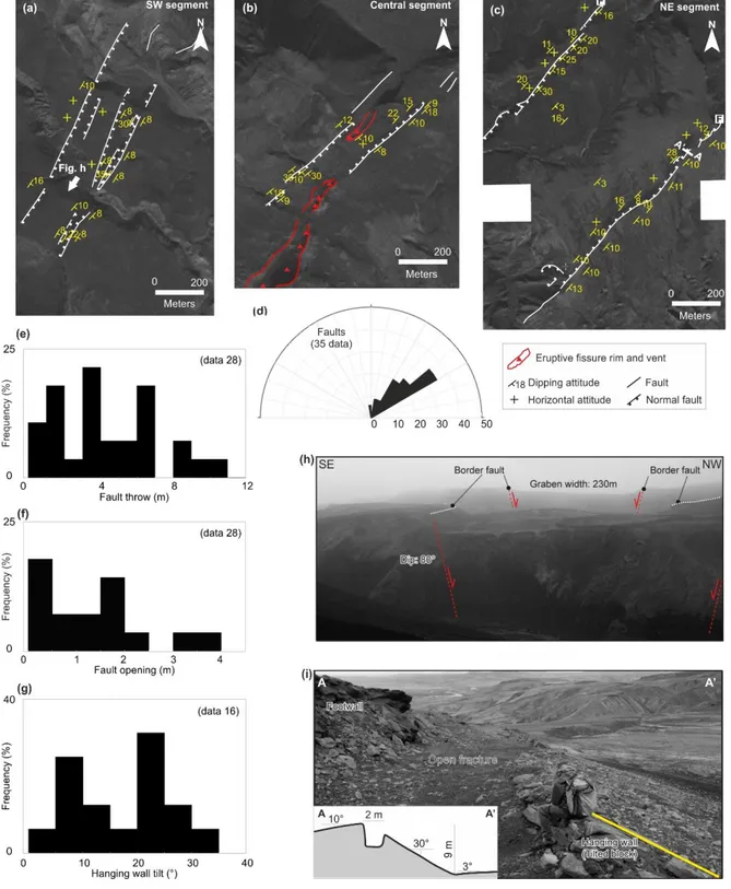
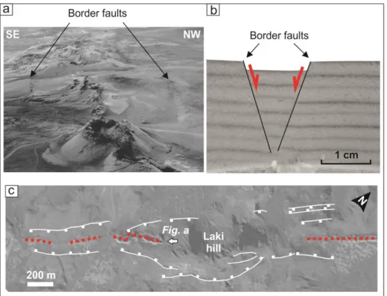
The 27 km long Lakagigar eruptive fissure is located in SE Iceland, in an area undergoing an overall extension rate of 10 mm/yr (Table 1) [Perlt et al., 2008]. The fissure belongs to the Grimsvotn volcanic system (East Volcanic Zone) and formed in 1783-1784, producing one of the largest historical basaltic lava flows (~15 km3); the feeder dike(s) propagated towards NE, forming ten en-echelon fissures [Thordarson and Self, 1993]. Our field survey focused on the ~4 km long central portion of the fissure in a nearly flat area, except for the ~200 m high and older Laki hill (Fig. 3). The N45°±5° striking fissure (Fig. 3d) is mostly centered within a graben bordered by N55°±5° trending normal faults with mean dip of 75° (Fig. 3a, b, c). In the flat areas north and south of Laki, the graben is 150-450 m wide. In
18 correspondence to Laki, the eruptive fissure becomes interrupted, but the border faults climb the hill, enlarging up to ~700-800 m distant; the deformation is accompanied by diffuse fracturing, given by additional normal faults and also extension fractures.
The mean vertical throw of the border normal faults along the fissure is ~3 m, locally reaching 10 m ~1.5 km north of Laki (Fig. 3e; Table 1). In addition, a mean tensile component of ~1.4 m is found between the footwall and the hanging wall of the faults (Fig. 3f). The hanging wall and the footwall are usually outward tilted of 5°-10° (Fig. 3c). The deformation on the border faults may be locally partitioned into several minor parallel normal faults, resulting in a widespread and less defined border (Section A-A’; Fig. 3g). The eruptive fissure, usually lying in the middle of the graben, may also locally coincide with the border fault (Section B-B’; Fig. 3g). This suggests that the border fault formed before the dike reached the surface and was subsequently reactivated by the dike to rise. Finally, the lateral termination of 8 normal faults bordering the graben shows open fracture structures (OPF type), suggesting that the normal faults nucleated at the surface and propagated downward (Table 1).
4.1.2 Eldgjá
The 75 km long and N45°E trending Eldgjá fissure belongs to the Katla Magmatic System (Iceland), undergoing an overall local extension rate is 9 mm/yr (Table 1) [Perlt et al., 2008]. The fissure results from at least two distinct rifting episodes, the last one in 933-941 AD [Hammer, 1984; Zielinsky et al., 1995], producing a total erupted volume of ~20 km3. The fissure can be divided in 3 main segments: a SW, a Central and a NE segments [Thordarson et al., 2001 and references therein]. Our field survey focused along 1 km on the SW and Central segments and along 4.5 km on the NE segment. All the segments consist of grabens and eruptive fissures. The graben is generally defined by discontinuous (200-300 m long) inward dipping normal faults and, at times, by minor parallel faults, also defining minor nested grabens (Fig. 4a). The fissure, when located within the graben, is partly bounded by the normal faults: otherwise, it may coincide with the border faults (Fig. 4b). In the investigated area, the N35°±5° to N65°±5° oriented eruptive fissure mainly crops out in the Central segment. The mean width of the graben containing the fissure is 230 m in the SW, 160 m in the Central and enlarges to 650 m in the NE segments (Fig. 4a, b, c; Table 1). However, the overall mean strike and throw of the border faults, of N40°±5° and 5±0.5 m respectively, remain consistent throughout the segments (Fig. 4d, e; Table 1). In each segment, the highest fault throw of the border faults reaches 10±2 m (Table 1). The mean fault dip, estimated in four well-exposed sections, is 78°±4° (i.e. Fig. 4h). Locally, the footwall
19 and the hanging wall of the border faults are separated by a tensile fracture 0.5 to 4 m wide (mean value of 1.5±0.2 m; Fig. 4f; Table 1). In correspondence with the SW and Central segments, the topography shows a regional tilt of ~10° toward SE, observed also on the footwall and hanging wall of the border faults (Fig. 4a). Along these two segments, the hanging wall tilt of the border faults towards the graben center is rare (<20% of the observations in the SW and central segment, respectively; Table 1). In the NE segment, the border faults display a dilational component; the footwall is flat or 10°±5° tilted outward with respect to the graben axis, whereas the hanging wall is commonly (76% of the observation) tilted toward the graben axis, with mean dip of 20° (Fig. 4g; Table 1). In between the hanging and footwall, the tensile fracture is 2±0.5 m wide (Fig. 4i). To the northern termination of the graben, the tips of two border faults show fault propagation folds (FPF type; Fig. 4c).
4.1.3 Bardarbunga
The deformation pattern associated with the 2014 rifting episode along the Bardarbunga volcanic system, Iceland, has been studied in October 2014 in the area of the eruptive fissure. This case provides an active example of dike-induced deformation at the surface and may help better understanding also the non active rifting episodes previously described. Seismicity, GPS and InSAR data suggest the lateral propagation of a dike, with maximum opening of 5 m close to the surface, from the Bardarbunga Central Volcano to 50 km northeastward in 2 weeks, reaching the surface at Holuhraun, to the south of Askja [Icelandic Met Office IMO, en.vedur.is; Gudmundsson et al., 2014 BV]. The dike caused at least 30 cm of outward horizontal displacement at the surface before erupting, in a few days; the resulting extension rate is much higher than the mean one, of 16 mm/yr (Table 1) [Perlt et
al., 2008]. Two fissure eruptions formed in a nearly flat area on August 29th and on August
31st. The latter, larger, is still erupting as of December 2014, producing a lava field >75 km2. Both fissures lie close to older fissures related to the 1910 rifting episode, when a lava flow likely buried a pre-existing graben and the associated border faults, forming a flat area. Satellite and aerial imageries show that during the 2014 diking episode a NNE-SSW trending, 0.8 to 1 km wide graben containing the eruptive fissure appeared at the surface [IMO, en.verdur.is]. The graben reaches the northern edge of the Vatnajokull Ice cap, with a length of ~6 km (Fig. 5a).
We carried out a field survey to better characterize the structure of the graben, focusing on the two border faults immediately to the north to the August 29th eruptive fissure, where the graben is 0.8 km wide. Both normal faults bordering the graben show a dilational
20 component, with flat footwall and 20°±5° inward tilted hanging wall (Fig. 5b, c, d). The faults strike N25 ±5° and have a mean vertical throw of 6±1 m. The tensile component between the footwall and the hanging wall is ~3 m on each fault (Fig. 5d). However, the hanging wall is locally separated in two or more blocks, with a cumulative opening reaching up to 7 m. Minor extension fractures (mean opening 0.5±0.2 m) are also present on the footwall, in a 30-40 m wide zone parallel to the fault. These fractures, mainly striking N15°±5°, merge along strike together and with the main fault (Fig. 5c).
4.1.4 Sveinagja
The 34 km long and ~1.5 km wide Sveinagja graben belongs to the Askja magmatic system of Iceland, undergoing an overall extension of 19 mm/yr (Table 1) [Perlt et al., 2008]. In the northern portion of the graben, a fissural eruption related to the 1872-1875 rifting episode produced a volume of 0.3 km3 of lava (Fig. 6a). This episode is also coeval to the formation of the Oskjuvatn caldera, in the 70 km distant Askja central volcano [Sigurdsson and Sparks, 1978]. In 1872-1875, the Sveinagja graben has been probably reactivated, as it formed during older diking episodes [Gudmundsson and Backstrom, 1991; Tentler and Mazzoli, 2005].
Our field survey focused along 4 km of the northern portion of the graben, where the eruptive fissure is centered within (Fig. 6a). Here the graben is ~1 km wide, with border faults striking N10°±5° (Fig. 6b). The highest measured throw of the border faults is ~10 m, whereas the average displacement is ~4 m (Fig. 6c). These data are consistent with previous studies [Gudmundsson and Backstrom, 1991; Tentler, 2005; Tentler and Mazzoli, 2005]. The faults are subvertical at the surface, usually showing a dilational component between the footwall and the hanging wall. The tensile area is usually ~2 m wide, locally reaching up to >10 m. The geometry of the faults also varies along strike. Both the footwall and the hanging wall are usually subhorizontal, but locally (in 40% of the observations) the hanging wall may be inward tilted up to 20° (Fig. 6d; Table 1). Each border fault system may locally consist of a smaller graben-like structure, 20-40 m wide, with a subsided block between the footwall and the hanging wall. The termination of 5 border faults segments, all grading in a series of open fractures on a flat topography, suggests an OPF type of lateral termination of the normal faults.
21 4.1.5 Sveinar
The 0.5 to 0.8 km wide and 20 km long Sveinar graben lies ~30 km north to Sveinagja. The Sveinar graben belongs to the Fremri-Namur volcanic system and formed mainly during the eruption of the Sveinar Lava, 6000-8000 years ago [Gudmundsson and Backstrom, 1991]. This eruption developed the NNE-SSW trending Rauduborgir-Randarholar crater row, partially contained within the graben (Fig. 7a). The graben continued to develop during the 1875 rifting episode at Askja-Sveinagja [Sigurdsson and Sparks, 1978; Tentler and Mazzoli, 2005 and references therein]. As a detailed analysis of the overall graben structure has been already provided [Tentler and Mazzoli, 2005], here we focused on the northernmost 1.5 km of the eastern border of the graben (Fig. 7b). This is segmented in 3 main normal faults striking almost N-S (mean strike N6°). The faults are subvertical at the surface and show a mean vertical throw of ~4 m, locally reaching 8 m, much smaller than the maximum throw of 23 m in central portion of the graben, out of our covered area [Tentler and Mazzoli, 2005]. Our investigated fault segment shows an open fault with dilational component between the footwall and the hanging wall up to 2 m wide. In general, the footwall and the hanging wall are flat, consisting of horizontal layers. Locally, the border fault is also accompanied by antithetic structures, forming minor and narrow grabens (Fig. 7b). Along ~200 m of the northern fault segment, the hanging wall is usually tilted of 20-25° (Fig. 7c), at times becoming subhorizontal or, conversely, reaching 65° and becoming subvertical at the hanging wall base (Fig. 7d, e). The throw and amount of the hanging wall tilt along the southern segment gradually decreases southwards and the fault grades into a series of open fractures with a minor graben like structure, within an almost flat area (Profile D-D’; Fig. 7b). This portion of the Sveinar graben highlights the coexistence of dramatic variations in the dip of the hanging wall of central portion of a border fault within an extremely limited area, a few hundreds of m long.
4.2 Rift segments
4.2.1 The Krafla magmatic system
The 80 km long and up to 10 km wide Krafla magmatic system of Iceland strikes NNE-SSW from Lake Myvatn to the north coast of Axarfjordur, undergoing a mean extension rate of 23 mm/yr (Fig. 8a) [Bjornsson et al., 1977; Perlt et al., 2008].In its central portion, it hosts the ~9 km wide active Krafla caldera, where most of the 35 Holocene eruptions occurred (Fig. 8a) [Bjornsson et al., 1977]. These eruptions included several rifting episodes, as the
22 1.5-2 ka old basaltic fissure eruptions in Kelduhverfi and spatter cones at Gjastykki, the 1724-1729 Myvatn fires and the most recent rifting episode in 1975-1984 [Opheim and Gudmundsson, 1989 and references therein]. During the latter episode, approximately 20 successive dike intrusions occurred, producing and reactivating fractures and normal faults [Bjornsson et al., 1977; Tryggvason, 1980; Einarsson, 1991]. Aerial imagery analysis and GPS networks related to this episode indicate a widening in the area of the eruptive fissure of ~9 m focused 10 to 12 km north to the caldera and decreasing northward (reaching 2-5 m) [Tryggvason, 1994; Buck et al., 2006, Hollingsworth et al., 2012]. Leveling data focused on two diking events also indicate that each caused 0.5-1 m of subsidence above the dike and ≥0.5 m of uplift to its sides, decreasing with distance from the dike [Rubin and Pollard, 1988; Rubin, 1992]. About ten years after the end of the rifting episode, the post rifting deformation still consists of several cm of horizontal opening and >10 cm of regional vertical uplift, much larger than the inter-rifting values [Hofton and Foulger, 1996].
Here we focus on the cumulative surface displacement of the magmatic system, as produced on the longer-term (hundreds of years or more) by normal faults and extension fractures dissecting the lava flows. In the the central portion, the magmatic system does not consist of a simple and single graben; rather, there is a 2-3 km wider graben, partly asymmetric, with several extension fractures and normal faults within, defining 30-300 m wide minor nested grabens (Fig. 8f). The mean strike of the faults is N8°, similar to the N12° of the extension fractures (Fig. 8b). The graben border faults are usually vertical at the surface with a tensile area between the footwall and the hanging wall; the largest fault, defining the western rim of the 2-3 km wide central graben, has a maximum throw of 42 m and maximum width of 28 [Opheim and Gudmundsson, 1989; Angelier et al., 1997]. The average fault throw of the border faults in our studied area is 5 m; the width of the tensile area between the footwall and the hanging wall of the faults is commonly ~3 m, locally reaching 5 m (Fig. 8e). The opening of the extension fractures is usually <1 m (Fig. 8e), smaller than the mean width of the tensile area of the normal faults. Most extension fractures at Krafla, even with opening of a few m, are found on a flat surface. The footwall of the normal faults is usually subhorizontal, whereas the hanging wall may be subhorizontal or 20°-30° inward tilted and locally separated in different collapsed blocks (Fig. 8d, h, i). Contractional structures are found at the base of the tilted hanging wall of the normal faults in two places: ~8 km north to the caldera rim and at the southern tip of the fissure swarm (Fig. 8a). The latter is along the 2 km long Grjotagja fault, in the Myvatn area, on the western boundary of a ~1 km wide graben on a ~2.7 ka lava flow. Here the fault striking N355°
23 displays 5-6 m of vertical throw, with a titled hanging wall of 30-35°, separated from the footwall by a 2 m open fracture (Fig. 8i, l). The well-exposed base of the tilted hanging wall consists of a strip parallel to the fault trace, 102 m long, of folded and at times chaotic lava blocks, indicating localized contraction. The best exposures systematically reveal a tight cylindrical fold, ~1 m wide and with an ~90° interlimb angle, whose axis is parallel to the fault (Fig. 8 m). The associated contraction of the fold is 7–20% of the horizontal extension [Trippanera et al., 2014a].A similar contraction at the base of the tilted hanging wall is found on a fault to the north of Grjotagja (Fig. 8a, 9) and on another fault north of Krafla caldera (Fig. 8a). Along the Krafla magmatic system, 95% of the observed fault tips (that is 18 out of 19) terminate as open fractures without any hanging wall tilt, or as OPF type (Table 1, Fig. 8g; Fig. 9).
4.2.2 Vogar rift zone
The 10 km long Vogar fissure swarm lies on the northern portion of the 35 km long and 5-8 km wide Reykjanes fissure swarm, in southern Iceland (Fig. 10a, b) [i.e., Gudmundsson, 1980; Villemin and Bergerat, 2013; Clifton and Kattenhorn, 2006]. The amount of pure extension of this highly oblique portion of rift is ~6 mm/yr [Keiding et al., 2008]. The Vogar fissure swarm consists of a 3-4.5 km wide asymmetric deformation zone delimited on the western edge by an east facing normal fault (Hrafnagjá) and on the eastern edge by a series of open fissures (Grindavikurgjá) [Villemin and Bergerat, 2013]. An inner graben hosts five major west facing normal faults, vertical at the surface and with a dilational component between the footwall and hanging wall. The footwall is subhorizontal and the hanging wall varies its dip from subhorizontal to tilted (~30°). The mean fault throw and width of the tensile area are ~2 m and ~1 m respectively, both reaching a maximum >10 m. Similarly to what observed at Krafla, at Vogar there is contraction at the base of the tilted hanging wall of normal faults, as for example one with vertical throw of a few meters bordering a ~20 m wide graben. Here the tilted lavas of the hanging wall abruptly terminate above the horizontal lavas of the inner graben, indicating the presence of a thrust or reverse fault, rather than folds, as in Krafla (Fig. 10e, f). Most extension fractures at Vogar, even with opening of a few m, are found on a flat surface. Field measurements show that 35 out of 42 lateral tips of the normal fault are tilted, forming a monocline and suggesting the presence of FPF types; the remaining 7 faults terminate as open fractures in a flat topography area, suggesting OPF types (Fig. 10c, d) [Norini et al., 2009]. These results are broadly consistent with previous
24 ones, highlighting that beyond their lateral tips, the normal faults continue as narrow monoclines and/or linear clusters of tension fractures [Grant and Katternhorn, 2004].
4.2.3 Thingvellir rift zone
The 10-20 km wide NE-SW trending Thingvellir rift zone belongs to the >60 km long Pleistocene Hengill Volcanic System and lies north to the Lake Thingvallavatn in Iceland (Fig. 10a, 11a). Similarly to Vogar, here the extension rate is very low [5 mm/yr; Perlt et al., 2008]. The inner part of the rift zone consists of a ~5 km wide graben delimited by several inward dipping conjugate normal faults dissecting basaltic lavas flows, pillow lavas and lake sediments >1.9 ka [Gudmundsson, 1987 and references therein; Bull et al., 2005]. The graben has been affected by up to 40 m of subsidence and 70 m of horizontal extension in the last 9 ka [Seamundsson, 1992].
Most of the border faults in Thingvellir show the typical dilational component, with flat footwall and tilted hanging wall. The vertical throws of the major faults are in the order of very few tens of meters, locally reaching 30-35 m. This is the case of the 7.7 km long Almannagja fault, delimiting the eastern graben border, and the 11 km long Hrafnagja fault, delimiting the western border (Fig. 11b, c) [Gudmundsson, 1987; Seamundsson, 1992; Bull et al., 2005; Sonnette et al., 2010]. Thingvellir also shows smaller Holocene normal faults with both flat footwall and hanging wall. Many extension fractures, even with opening of a few m, are found on a flat surface. Field measurements at Thingvellir show that 22 out of the 26 observed lateral terminations of the normal faults are tilted, suggesting a FPF type: among these is the southern termination of the large Almannagjà Fault, bordering the graben (Fig. 11d, e); conversely, only 4 terminations show a flat footwall and hanging wall, resembling a OPF type [Norini et al., 2009].
4.2.4 Fantale magmatic system
The Fantale magmatic system lies in the central portion of the continental Main Ethiopian Rift (MER), Ethiopia, where the mean extension rate is ~7 mm/yr [Fernandes et al., 2004]. From a structural point of view, this area is probably the most representative of the MER, as it hosts recent and well-preserved fault and fracture systems (i.e., fissure swarm), well expressed along the southern sector of the Fantale caldera. The last historical eruption in the southern sector occurred in 1810 AD [Williams et al., 2004] evidenced by a lava field and a series of N25° aligned cinder and splatter cones. The fissure a swarm follows an overall NNE-SSW orientation and is characterized by extensional fractures and normal faults
25 that dissect the 168±38 ka welded tuff, originating from the Fantale caldera [Williams et al., 2004]. The fissure swarm, developed during the last 7 ka, focuses in a 3 km wide and 15 km long area [Williams et al., 2004 and references therein].
Our field survey has been carried out across a principal graben structure, located between the base of the volcano to the lake shoreline to the South. It has a central 2.5 km wide depression, delimited by two main inward dipping normal border faults oriented N24°±12° oriented (Fig. 12b). The faults show a constant dilational component of a few meters between the footwall and the hanging wall (Fig. 12e, 12g). The throw on the border faults reaches 10-15 m on the western and 15-20 m on the eastern border. The mean tilt of the hanging wall tilt is of 30°10°, but may reach locally up to 88° (Fig. 12c). Similarly to Krafla and Vogar, local contraction structures parallel to the fault strike have been observed in the central graben (Fig. 12d) [Trippanera et al., 2014a]. At the graben center, several areas of extension fractures, showing an opening of 1-2 m, grouped in different fracture swarms (Fig. 12f). The analysis of the terminations of the principal faults reveals that 14 out of 26 tips have a tilted hanging wall, suggesting a FPF type, whereas 12 fault terminations show an OPF type. Most of the FPF type of termination (10 cases) are located along the border faults. Conversely, most of the OPF types of termination (11 cases) are located inside the graben. To the North of Fantale, sparse border faults are observed with poor accessibility due to dense vegetation coverage. We generally observed similar structures compared to the South.
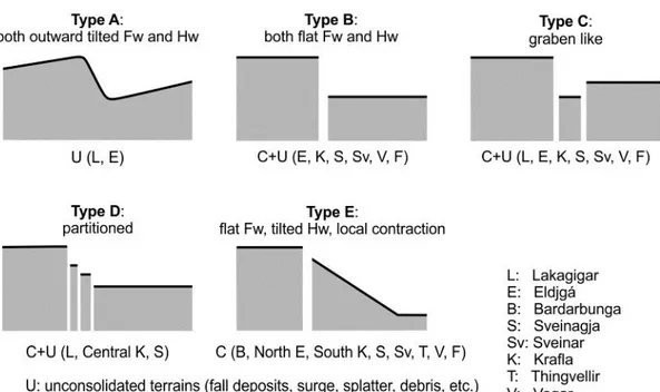
5 - Discussion
5.1 – Interpreting the collected data
All the considered studied areas, independently of the nature of the involved crust (oceanic or continental) and the amount of extension, display an overall similar deformation pattern, given by eruptive fissures, extension fractures and normal faults. Normal faults usually form graben-like structures hosting eruptive fissures. In the case of simple eruptive fissures (Laki, Eldgja, Sveinagja, Sveinar, Bardarbunga), the graben is narrow (1 km or less) and usually symmetric. In the case of the rift segments (Krafla, Vogar, Thingvellir, Fantale), the few km wide graben may also show some degree of asymmetry, hosting nested grabens within and extended fracture swarms. The morphology and structure of the normal faults of the graben(s) may vary along the eruptive fissures or the rift segments: the most common types of fault morphology and structure, in section view, are summarized in Fig. 1SM