A revised PAlAeogene lithostrAtigrAPhic frAmework for the
northern swiss JurA And the southern uPPer rhine grAben And its relAtionshiP to the north AlPine forelAnd bAsin
Claudius Pirkenseer1,3, Gaëtan rauber1 & stéPhane roussé2 1 Paléontologie A16, Office de la culture, Rue de la Chaumont 13, CH-2900 Porrentruy.
2 Beicip-Franlab, 232 avenue Napoleon Bonaparte, FR-92500 Rueil-Malmaison. 3 Earth Sciences, Université de Fribourg, Chemin du Musée 6, CH-1700 Fribourg.
To cite this article: Pirkenseer C., Rauber G. & Roussé S. (2018) - A revised Palaeogene lithostratigraphic framework for the northern Swiss Jura and the southern Upper Rhine Graben and its relationship to the North Alpine Foreland Basin. Riv. It. Paleontol. Strat., 124(1): 163-246.
Abstract. The Palaeogene deposits in the Swiss Molasse Basin, the intermediate Swiss Jura and the adjacent southern Upper Rhine Graben represent an excellent case study for interbasinal sedimentary and palaeogeographic relationships. The topographic and geologic complexity of the area led to an accumulation of local stratigraphic terms during nearly 200 years of research activity, necessitating a simplification of the lithostratigraphic framework. Additionally, the extension of the investigated area over two historically shifting language areas and the absence of a standardised supraregional lithostratigraphy adds to complexity of the situation.
In revising and grouping around 200 multilingual Palaeogene lithostratigraphic terms and spellings from the northern Jura and the southern Upper Rhine Graben that accumulated since 1821 we propose a concise standard-ised framework of 10 formations (6 new and/or emended) and 6 new members. It avoids the confusing multitude of historic “formation” names and stratigraphic ambiguity like the “Septarienton”, “Molasse alsacienne” or the “Cyrenenmergel”. The new formations include the Turckheim Formation (formerly “Steingang”, “Conglomérats côtiers”), the Rossemaison Formation (formerly “Terre jaune”, “Gelberde”), the Pulversheim Formation (formerly “Melettaschichten”) and the Wahlebach Formation (formerly “Cyrenenmergel”, partim “Molasse alsacienne”). The Wallau and Hochberg subformations are emended and elevated to formation status. For all discussed units except the Sidérolithique new reference and/or type sections are provided and illustrated. This new framework is put in context to recent stratigraphic schemes from adjacent areas in the Upper Rhine Graben, proposing status changes and emendations for existing units (e.g. Wallau-Subformation emended to Wallau Formation). To illustrate the former complexity and the proposed standardisation in the larger area, we applied the lithostratigraphic context to 9 palaeogeographic maps.
New heavy mineral data from the Delémont Basin complements the scarce regional information and is dis-cussed in relation to Palaeogene tectonosedimentary context of the North Alpine Foreland Basin and the southern Upper Rhine Graben.
Received: July 06, 2017; accepted: December 22, 2017
Keywords: lithostratigraphic correlation; formation revision; Eocene; Oligocene; clastic sedimentology; interbasinal relationships; heavy minerals.
1 I
ntroductIonDuring the last two decades the study of the Cenozoic deposits of the so-called “Jura-Molasse” re-intensified due to the construction of motorway A16 in northwestern Switzerland, stimulating more complex interpretations of the regional palaeogeog-raphy linked to lateral facies changes. These deposits represent the interface of two major tectonic units: the Upper Rhine Graben (URG) and the North Alpine Foreland Basin (NAFB, “Molasse Basin”; Fig. 1, 43), hence leading to a complex palaeogeo-graphic history and an alternating provenance of
regional sediments. The tectonic evolution (folding and thrusting of the Jura mountains) of the studied area led to the erosion of formerly more widespread sedimentary units to relics preserved in topographi-cally separated synclines. The palaeogeographic com-plexity also led to the deposition of locally confined facies or condensed lateral equivalents of well-devel-oped sedimentary successions in the adjacent main basins. During nearly 200 years of local and region-al research activity this consequently resulted in the accumulation of numerous, partly overlapping or substituting stratigraphic terms (Fig. 3-7). Despite the elaboration of detailed summaries of the known lithostratigraphic units (e.g. Sittler 1965; Doebl 1970; Picot 2002; Becker 2003; Berger et al. 2005a), no
Pirkenseer C., Rauber G. & Roussé S.
164
comprehensive formal definition of formations and designations of concise names took place.
New stratigraphic and micropalaeontological data from the southern URG (e.g. Roussé 2006; Picot et al. 2008; Pirkenseer & Berger 2011) including the Delémont, Laufen and Ajoie subbasins as well as the elaboration of homogenized lithostratigraphies (e.g. Grimm et al. 2011b; LGRB 2011) for adjacent areas needed to be integrated to achieve a better under-standing of the larger stratigraphic context of the in-dividual formations. The choice of type localities and names outside the Delémont, Ajoie and Laufen sub-basins proved necessary since for the Oligocene the local deposits represent condensed marginal exten-sions of formations closer to the depositional cen-tre(s) of the southern URG. Since the evolution of
tectonic events was triggered by respective phases of the alpine orogeny, progressing along a comparative-ly similar timeline throughout the (southern) Upper Rhine Graben, supraregional lithostratigraphic units should be homogenized. A large tectonic feature as the Upper Rhine Graben extending over three coun-tries and two language areas greatly benefits from common formation names based on geographic terms, and not as is the case up to now on predom-inantly descriptive, ambiguous, partly vaguely or in-consistently defined terms that need to be translated (e.g., Marnes à Cyrènes, Cyrenenmergel, Cyrena Marls = Hagenbach, Retzwiller and Courroux Members).
As clarified below only one lithostratigraph-ic unit will keep its historlithostratigraph-ical name (Sidérolithique), whereas for others new names will be proposed (e.g. Fig. 1 - Geographic overview and subdivision of Cenozoic basins
(German federal states in italics; adapted from Berger et al. 2005a).
Fig. 2 - Geographic distribution of analysed sections (for basin sub-division see Fig. 1): 1 Brochene Fluh, 2 Logs Tüllingen Hill, 3 drilling Allschwil-2, 4 Laufen, 5 Fichtenrain (Therwil), 6 Stutzweg (Therwil), 7 Dornachbrugg - River Birse, 8 Biel-Benken & Leymen, 9 Blauen-3, 10 Lörrach logs, 11 Rheinweiler, 12 Kandern area logs, 13 drilling COM-F5, 14 drilling DP-202, 15 drillings HRT-F8 & 9, 16 Folgensburg, 17 Heidwiller, 18 CRD-VRR (La Verrerie), 19 CRD-POI C-142 & CRD-PRC C-5, 20 Courroux - River Birse, 21 DEL-BEE C-19, 22 Près-Roses mine shaft, 23 River Sorne bed, 24 River Scheulte & Birse bed, 25 Burg-Biederthal, 26 Bouxwiller-Oltingue, 27 Eguisheim, 28 Turckheim, 29 dril-ling RNA-F1 & 2, 30 drildril-ling CHM-F4, 31 Retzwiller, 32 Burnhaupt-Le-Haut, 33 Güwenheim, 34 drilling ETA-F2, 35 drilling CLJ-F1, 36 Froidefontaine, 37 Hagenbach, 38 POR-OIP C-4, 39 Réchésy.
Steingang, Conglomérates côtiers = Turckheim Fm) or adapted from already well-defined formations from adjacent areas. Some units are subject to status changes (e.g. Cyrenenmergel as member of the [new] Wahlebach Fm; Fig. 40, 44).
Abbreviations: URG = Upper Rhine Graben, NAFB = North Alpine Foreland Basin, USM = Untere Süsswassermolasse, UMM = Untere Meeresmolasse, OSM = Obere Süsswassermolasse, OMM = Obere Meeresmolasse, Fm = formation, Mb = member
2 P
revIousstratIgraPhIcworkDuring the initial phase from the 1820ies to 1870 geognostic investigations often concerned the larger area of the French Departments Bas/
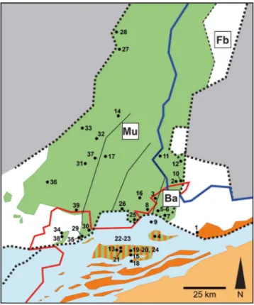
Haut-Rhin (e.g. Voltz 1828; Daubrée 1852; Delbos & Köchlin-Schlumberger 1867) (Fig. 3). While Daubrée (1852) described many Cenozoic depos-its in detail (e.g. “Couches de Bechelbronn”), their stratigraphic position remained ambiguous. A first ordered lithostratigraphy was presented in Delbos & Köchlin-Schlumberger (1867), introducing amongst others the later common terms “Schiste à poissons”, “Tongrien”, “Grès à feuilles” and “Marne à Cyrènes” for selected Rupelian deposits. Merian (1821) and Greppin (1870) dealt explicitly with the geology of the Jura mountains, though Merian (1821) was somewhat hampered being the first to discuss also the Cenozoic deposits, their de-scription remaining rather vague. Greppin (1870) went much more in detail describing the succession Fig. 3 - Correlation of past
lithostra-tigraphic concepts in chro-nological order (part 1).
Pirkenseer C., Rauber G. & Roussé S.
166
of each syncline in a stratigraphic order and present-ing a first comprehensive lithostratigraphic synthesis (introducing e.g. the “Terre jaune”, “Delémontien”) with correlations to adjacent basins (Fig. 3).
Following a short hiatus Andreae (1884) and Kilian (1884) proposed extended lithostratigraphies for the southern and middle upper Rhine Graben, establishing the “modern” pattern that has been refined since (Fig. 3). The few still erroneously po-sitioned deposits concern parts of the widely dis-tributed conglomerates and sands along the borders of the URG, which remained notoriously difficult to attribute. These problems were only finally solved by the extensive analysis of the entire conglomeratic complex by Duringer (1988).
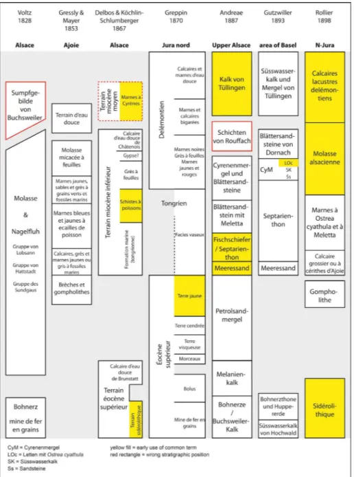
The following years brought a refinement on a regional scale with the establishment of the initial ge-ological maps of the Jura area and more specialized analyses of selected stratigraphic units (e.g. Rollier 1893a, b, 1898, 1910; Gutzwiller 1893; Förster 1888, 1892; Kessler 1909; Wurz 1912). The bimodal nam-ing of lithostratigraphic units based on French and German terms gets established around that time.
The following years were characterised by a first emendation / completion of geological maps of NW Switzerland (e.g. Koch 1923; Liniger 1925; Buxtorf & Christ 1936) and an important NW-SE correlation of Rupelian sediments between the southernmost URG and the Swiss “Molasse Basin” (Baumberger 1927).
Fig. 4 - Correlation of past lithostra-tigraphic concepts in chro-nological order (part 2).
Further interest in the southern URG was spurred by the discovery of large Cenozoic salt de-posits at the end of the 19th century and renewed in-terest in the oil reservoir of the Pechelbronn area at the beginning of the 20th century, leading to vastly increased drilling activity and investigation of cored material (e.g. Förster 1909b; van Werveke 1918; Christ 1924; Meyer 1928; Barbier 1938; Maïkovsky 1941; Vonderschmitt 1942; Schnaebele 1948), add-ing more precision to the data formerly obtained mainly from outcrops and clarifying the stratigraph-ic situation in the basin centre.
Stratigraphic research in the southern URG and the Jura increased due to the intensified map-ping activity to complete / emend geological maps
in NW Switzerland (Diebold 1960; Schneider 1960; Tschopp 1960; Fischer 1965a; Fig. 5) and (renewed) interest in old and not exhaustingly treated topics (e.g. clay mineralogy, palaeoclimatology and stra-tigraphy, Sittler 1965; “Meeressand”, Wittmann 1967). This trend continued more or less in the 80ies and early 90ies (e.g. marginal URG conglom-erates, Duringer 1988; “Schistes à poissons” fish as-semblages, Pharisat 1991a; geological maps of NW Switzerland, Fischer et al. 1971; Bitterli-Brunner & Fischer 1988). A pivotal lithostratigraphic summary of the southern URG comparing different subba-sins was elaborated by Sittler (1965), incorporating much of the previously available information in a complete chart (Fig. 6).
Fig. 5 - Correlation of past lithostra-tigraphic concepts in chro-nological order (part 3).
Pirkenseer C., Rauber G. & Roussé S.
168
From the second half of the 90ies until recently increasing numbers of theses and publications deal-ing with the “Jura Molasse” and the southern URG were owed to research projects initiated in Switzerland (Universities of Basel, Bern, Fribourg and Zürich) and France (University of Strasbourg), partly in the framework of the transnational EUCOR-URGENT project (Behrmann et al. 2005). These publications provided fresh insights and global summaries on palaeontologic, palaeogeographic, geochemic and bi-ostratigraphic aspects (e.g. Schlunegger et al. 1996; Kälin 1997; Clément & Berger 1999; Picot 2002; Storni 2002; Becker 2003; Hinsken 2003; Berger et al. 2005a,b; Roussé 2006; Picot et al. 2008; Le Metayer 2007; Pirkenseer 2007; Fig. 6-7).
The most recent comprehensive lithostrati-graphic summaries treat either the entire URG (Grimm et al. 2011b) or the part lying within the federal state Baden-Württemberg (LGRB 2011). Unfortunately both references were published only in German.
3 g
eologIccontextThe URG represents the 300 km long, roughly N-S trending central part of the European Continental rift system (ECRIS, Ziegler 1992) ex-tending between Wiesbaden (Germany) and Basel (Switzerland) (Fig. 1). Several hundred to over
thou-Fig. 6 - Correlation of past lithostra-tigraphic concepts in chro-nological order (part 4).
sand meters of Palaeogene southern URG basin sed-iments are mostly covered by Quaternary deposits of the Rhine River. The crystalline basement and the Triassic “Buntsandstein” cover of the Vosges and Black Forest mountains bordering the URG to the east and the west (e.g. Sittler 1992). Outcrops of Cenozoic sediments are generally distributed along river valleys and near the graben margins. Near the latter conglomerates containing medium to large-size gravels of different origin (Duringer 1988) or coastal marine sands (Roussé 2006) are dominant. Towards the centre of the basin grain sizes get progressively finer. The basin fill consists mainly of lacustrine to marine sands, marls and massive evaporitic deposits (“Potash Basin” north of Mulhouse, Dannemarie
Basin). Neogene deposits are nearly absent in the re-gion south of Strasbourg, but are well-documented in the Delémont and Ajoie subbasins (Liniger 1925; Kälin 1997; Becker 2003).
Based on the sedimentary history rifting start-ed in the mid-Eocene (e.g. Sittler 1992; Sissingh 1998; Berger et al. 2005 a,b) due to the build-up of a N-S directed stress regime after the closure of the Valais Ocean and the accretion of the Briançonnais terrane (Stampfli et al. 1998; Ziegler & Dèzes 2005). This induced a strike slip motion along reactivat-ed WSW-ENE trending late Palaeozoic fault lines (Schumacher 2002), separating the URG into several subbasins. South of Mulhouse the URG is further subdivided by north-south trending faults into the Fig. 7 - Correlation of past
lithostrati-graphic concepts in chronolo-gical order (part 5).
Pirkenseer C., Rauber G. & Roussé S.
170
Fig. 8 - Palaeogeographic representation of major facies and regional lithostratigraphic terms (updated from and based on maps in Berger et al. 2005b). Top of the figure represents the formerly used most common terms, lower part the status after revision and simplification. 8a Map for the Bartonian, 8b Map for the Priabonian.
Dannemarie Basin in the west, the Mulhouse Horst and several half-grabens in the east (e.g. Rotstein et al. 2005). The tabular and folded Jura Mountains (Mesozoic) frame the rift valley to the south. In this area Cenozoic deposits are found in the synclines of the folded Jura as well as the Delémont, Laufen and Ajoie subbasins (e.g. Becker 2003), which are tectonically related to the main URG rift (e.g. Picot et al. 2005) but have been overprinted by the Jura folding since the late Miocene.
The Jura Mountains are themselves bordered by the North Alpine Foreland Basin (NAFB) to the southeast (Fig. 1), emphasising the important palae-ogeographic role of this intermediate area and its Cenozoic sedimentary and tectonic history for in-terpreting interbasinal relationships.
4 l
argerP
alaeogenestratIgraPhIc evolutIonThe oldest common synrift deposits (ex-cluding the Sidérolithique) related to the initial rifting phase (Sittler 1992; Sissingh 1998; Berger et al 2005a,b) in the southern URG date from the Lutetian, whereas in the Ajoie and Delémont subbasins they are younger (latest Priabonian, ear-ly Rupelian) (Liniger 1925; Berger et al. 2005a,b; Picot et al. 2008) (Fig. 8b, 13a, 43), and are younger still in the Laufen subbasin (late Rupelian). Highly fragmentary terrestrial to lacustrine sediments (e.g. Koch 1923; Liniger 1925) in the individual subba-sins probably indicate tentative tectonic influence related to the URG rifting in the area. Depending on their geographic position the residual clays of the underlying Sidérolithique are accordingly of strongly varying ages (Lutetian-Priabonian; Becker et al. 2013b) (Fig. 8).
The deposition of hundreds of metres (max. over 2000 m) of predominantly lacustrine marls, limestones, conglomerates and evaporites (berger et al. 2005a,b; Grimm 2005; Grimm et al. 2011b) indi-cates the acceleration of the rifting during the late Lutetian to the early Rupelian (e.g. Sissingh 2006).
In the basal Rupelian a first marine ingres-sion (“Zone fossilifère”, “Mittlere Pechelbronn-Schichten”) invades the URG basin from the North via the Hessian depression. This transgression-re-gression cycle is evidenced by microfossil assem-blages (Grießemer et al. 2007; Grimm et al. 2007;
Lavoyer 2013; Pirkenseer & Berger 2011). It reach-es southwards into the Wolschwiller halfgraben (Pirkenseer & Berger 2011) and the Ajoie subbasin (Picot et al. 2005, 2008), but not the Laufen and Delémont subbasins.
A second, more pronounced late Rupelian transgression-regression cycle affected the entire URG and reached the Ajoie, Delémont and Laufen subbasins (Clément & Berger 1999; Picot et al. 2008) (Fig. 13b, 23). In the URG this led to the dep-osition of a several hundred meters thick marine series (“Série grise”, “Froidefontaine Subgruppe”; Berger et al 2005 a, b; Grimm et al. 2011b), which came gradually under influence of detrital sedimen-tation of alpine provenance after the overfill of the NAFB, indicated by the northwards directed progradation of a delta system in the research area (Roussé 2006; Pirkenseer et al. 2011) (see 8 and Fig. 23b, 28a, 43). The presence or absence of individual members and formations subdividing these marine to deltaic sediments in the regional subbasins is dis-cussed in this paper.
During the latest Rupelian and Chattian fluvio-lacustrine conditions became established (Niederroedern Fm, “Molasse alsacienne”) as northwards directed branch of the axial drainage system of the NAFB (“Genfersee-Schüttung”, e.g. Füchtbauer 1964) (Fig. 28). The Palaeogene sedimentation culminated in the deposition of the Tüllingen Fm with predominant freshwater limestones (e.g. Picot 2002; Berger et al. 2005a, b; Grimm et al. 2011b) (Fig. 28).
5 M
ethodsSynonymy lists are comprehensive and may include some references not dealing directly with stratigraphic issues (e.g. Schumacher 2002). They illustrate the confusing variety of lithostratigraphic terms and translations used throughout the litera-ture. Individual authors may have applied more than one term or translation to an individual lithostrati-graphic unit (e.g. Delbos & Köchlin-Schlumberger 1866; Sissingh 1998).
The lithostratigraphic terms ante-revision applied to the palaeogeographic maps (Figs 8, 13, 23, 28, 39) are derived from the historically most commonly used names in the corresponding ar-eas. Adapted or not modified terms post-revision
Pirkenseer C., Rauber G. & Roussé S.
172
are based on the most recent available stratigraphic overviews in the respective areas (e.g. Roussé 2006; LGRB 2011; Grimm et al. 2011b; LLS 2014).
The naming of formations follows the guide-lines advanced by the International Commission on Stratigraphy (http://www.stratigraphy.org).
Coordinates of indicative localities are as pre-cise as possible, but may be positioned in the mid-dle of a group of outcrops or in the close vicinity when based on descriptions in older literature. The approximate geographical positions of localities are indicated in Fig. 2, their relative stratigraphical po-sition in Fig. 45.
To achieve a better understanding of the larger lithostratigraphic context the available outcrops are combined with selected drill cores. Granulometric classifications are based on estimates, which are substituted by selected control measurements. The granulometric classification follows Blair & McPherson (1998). Lithofacies denominators
fol-low a custom scheme (see Roussé 2006).
To attain a continuous stratigraphical record of heavy mineral suites data was obtained from two cores drilled near the southern Delémont Basin mar-gin southeast of the village Courrendlin. While drill-ing HRT-F8 (47.33602° N / 7.38169° E) covers the lithostratigraphical units from the Sidérolithique to the Niederroedern Fm (Eocene to Chattian), drilling HRT-F4 (47.33962° N / 7.38097° E) supplements the range from the Niederroedern Fm to the Bois-de-Raube Fm (Chattian to Burdigalian). Selected outcrops complement data for the Heidwiller Mb (PRC004-41, POI007-229) and Sidérolithique karst pockets (VRR005-69).
Heavy mineral analyses were carried out in the Laboratories for Applied Organic Petrology (LAOP) in Lauta (Germany). Depending on grain size sample weights between 200-400 gr were chosen for analy-sis. For disaggregation samples were soaked in H2O2 and treated subsequently in ultrasound baths. Acetic Fig. 9 - Abbreviations and symbols.
acid was used to dissolve carbonate cement. After wet-sieving the grain sizes 63-100 µm and 100-200 µm were chosen for gravity separation. The separa-tion liquid applied was sodium polytungstate solusepara-tion with a density of 3 gr/cm3. Mineral grains were em-bedded in meltmount with refraction index of 1.662. During optical analysis 300 grains per fraction were determined by band count on a scanning stage.
6 s
ynonyMy,
defInItIonanddescrIPtIonofforMatIonsandgrouPs
6.1 sidérolithique / siderolithikum (Fig. 8)
6.1.1 Synonomy and generalities
• Eisenstein (Merian 1821)
• Bohnerz, Bohnerzton, Bohnerzformation (Bolus) (Voltz 1828, Rollier 1904, Buxtorf & Christ 1936, Gander 2013)
• Terrain(s) sidérolithique(s) (Thurmann 1836, Gressly 1841, Delbos & Köchlin-Schlumberger 1867, Greppin 1870, Rollier 1893a,b)
• Minerai de fer sidérolithique (Kilian 1884)
• Sidérolithique (Rollier 1893a,b, Fleury 1909, Meyer 1928, Sittler 1965, Clément & Berger 1999, Berger 2011, LLS 2014)
• ?Calcaires / Gompholithes de Daubrée (Fleury 1909, Liniger 1925, Buxtorf & Christ 1936, Sittler 1965)
• Bolus und Tonerz, Huppererde, Bohnerzkonglomerate (Liniger 1925; Fischer 1965a)
• Siderolithikum (Buxtorf & Christ 1936, Fischer 1965a, 1969, Doebl 1970, Bitterli-Brunner & Fischer 1988, Gander 2013)
• Sidérolithic, Siderolithic (Duringer 1988, Sissingh 1998, 2006, Berger et al. 2005a)
• Groupe du Sidérolithique (Picot 2002, Becker 2003) • Siderolith-Schichten (Grimm et al. 2011b, for additional older
synonymy therein, DSK 2016)
• Bohnerz-Formation, Schliengen-Formation (LGRB 2011, DSK 2016)
The traditional (e.g. Thurmann 1836) name will remain unchanged due to the widespread occur-rence of the formation and the absence of an ap-plicable type section. The newer name “Siderolith-Schichten” in Grimm et al. (2011b) is misleading, since the Sidérolithique generally does not occur in well-defined beds, as indicated by the German term “Schichten”. Older authors name the formation af-ter its most important (economic) aspect, namely the pisolitic iron ore (“Bohnerz”, “fer pisolithique”; Merian 1821; Voltz 1828; Daubrée 1852).
Picot (2002) considers the Sidérolithique itself as a group, but the grouped units (e.g. “Bohnerzkonglomerat”, “Hupper”) are of a too minor extent to merit a formation status. LGRB
(2011) groups all residual sediments (Palaeogene and Neogene) as “tertiäre Residuallehme”, whereas for the URG the Sidérolithique is treated as discrete, but lithologically similar Schliengen-Formation (see also GeORG 2013).
6.1.2 Definition, distribution and thickness
The Sidérolithique consists of residual clays of often reddish and yellowish colours, deposited in karst fissures or directly on underlying Jurassic lime-stones in erosional depressions. The latter are proba-bly a result of relief due to large-scale crustal flexur-ing / bucklflexur-ing in the Palaeocene to late Eocene (e.g. Bourgeois et al. 2007; Dèzes et al. 2004).
Iron pisoliths are generally present, either distributed throughout the sediment or enriched in “pockets”. Sizes range from sub-millimetric to cm-large irregular specimens and aggregations. The sec-ondary nature of the accumulation of iron pisoliths in minable ore deposits through reworking has been discussed in Wittmann (1955). Locally quartz-rich sands may be intercalated, known as “Huppersand/-erde” / “sables silicieux vitrifiables” (Greppin 1870; Fleury 1909; Christ 1924). Primarily eroded from crystalline rocks of the Massif Central in the Cretaceous, they have been regionally reworked and accumulated due to fluviatile processes in the Eocene (Aubert & Le Ribault 1974). These sands may poten-tially be classified as a disjunct member, since Christ (1924) indicates maximal thicknesses of more than 10 m. Rare limestones and conglomerates (“gom-pholithes de Daubrée”) have been attributed to the Sidérolithique s.l. (Picot 2002), their stratigraphic re-lationships however remain ambigous.
Considering the residual state of the depos-its, karst infills represent the most common occur-rences (e.g. site Courrendlin-Verrerie; 47.31606° N / 7.39325° E) that are scattered over the entire research area. Karst infills overlain by horizontal Sidérolithique deposits can be observed in drill cores (COM-F5, HRT-F9; Fig. 10-12). Karst fissures may descend more than 10 m into the underlying substratum (e.g. drilling HRT-F9; Fig. 11), and even down to about 100 m near Seehof (Canton of Berne, Switzerland; Bläsi et al. 2015).
The Sidérolithique was partially eroded in the early Oligocene. This is born out by reworked Sidérolithique in the basal Rossemaison Fm (see 6.2). In the Laufen subbasin the marine Pulversheim Fm was partly deposited directly on the bio-eroded
Pirkenseer C., Rauber G. & Roussé S.
174
Fig. 10 - Log of the drilling Delémont-Communance (COM-F5) from the Delémont subbasin centre, showing a near complete though con-densed succession of Cenozoic sediments (Switzerland).
Jurassic substratum (see logs in Roussé 2006; Picot et al. 2008), with a cm-thick reddish clay layer at the base hinting at the presence of an erosional rem-nant of Sidérolithique.
Thicknesses in the Delémont area range from around 20 cm (HRT-F8) at the margin of the subbasin to around 18 m (COM-F5) in the centre. Grimm et al. (2011b) indicate a maximum thickness of 64 m in the southern Upper Rhine Graben in drill cores.
Clay minerals of the Sidérolithique are dom-inated by kaolinite with illite being scarce (Sittler 1970). Interestingly the clay mineral assemblage of the so-called “Calcaires / Gompholithes de Daubrée” is markedly different with abundant il-lite and low to moderate contents of kaolinite and chlorite in the conglomerates (“gompholithes”), and a high content of palygorskite in the limestones (Sittler 1965).
6.1.3 Type, reference and classic localities
So far no type locality has been assigned, since no outcrop section showing both karst pockets and layered deposits exists. A generalized section of the Sidérolithique in the Delémont Basin has been pro-posed by Fleury (1909) based on cumulative observa-tions in mine shafts. The exemplary section from the Delémont Basin margin in drilling COM-F5 (153.0 to 140 m, Fig. 10) may be considered as a type sec-tion, though the observed thickness does not come close to the maximum thickness in the URG cited by Grimm et al. (2011b).
6.1.4 Differentiation from other units
The underlying Jurassic limestones can always clearly be separated from the Sidérolithique, where-as the transition to the overlying yellowish marly Rossemaison Fm deposits (see 6.2) in the Delémont subbasin is rather gradual, with a redeposition and mixing of Sidérolithique sediments. In areas outside the Delémont Basin other clearly distinct lithostrati-graphic units may be deposited directly on or include eroded Sidérolithique at the base (e.g. conglomeratic Turckheim Fm, sandy Wahlebach Fm).
Insufficiently documented local lime-stones and conglomerates termed “Calcaires de Daubrée” and “Gompholithes de Daubrée / Bohnerzkonglomerat” have been attributed to the Sidérolithique (Fleury 1909; Liniger 1925; Buxtorf & Christ 1936; Picot 2002), based on the proximity of
“true” Sidérolithique deposits and a certain content of ferruginous cement and pisoliths. Since (bio)strati-graphic evidence is lacking, a definitive correlation with either the Sidérolithique, the basal conglomer-ates of the Turckheim Fm (see 6.3) or the limestones of the Bouxwiller Fm (Grimm et al. 2011b) remains difficult. A similarity of clay mineral assemblages of the Bouxwiller Fm and the “Calcaires de Daubrée” (Sittler 1965) probably indicates a comparable depo-sitional environment.
These scattered conglomerates and lacustrine limestones may have been deposited simultaneously with the Sidérolithique in areas with a stronger local relief.
6.1.5 Age and fossil content
The Sidérolithique has scarcely been dat-ed. Outside the research area in the Swiss Molasse Basin the biostratigraphic age ranges from MP14-19 (late Lutetian to late Priabonian; see listing in Becker 2003). In the research area the fossil-rich site Courrendlin-Verrerie was recently correlated with small mammal zone MP16 (Bartonian; Becker et al. 2013b). To the north in the Upper Rhine Graben no autochthonous age has been documented so far (see Grimm et al. 2011b), but the Sidérolithique should be older than the overlying Bouxwiller Fm attributed to small mammal zone MP13b (Jaeger 1971), thus distinctly precedes the Sidérolithique at Courrendlin-Verrerie.
The assemblage from the Courrendlin-Verrerie karst pockets (Becker et al. 2013b) consists of numer-ous mammal teeth (e.g. Elfomys engesseri, Mixtotherium lavergnense), crocodile teeth and abundant bone
frag-ments. Many other localities of the research area are barren of fossils, except for reworked Mesozoic bio-ta. An early faunal overview of the Sidérolithique has been provided in Fleury (1909).
6.2 r
osseMaIsonf
M(
ext
errejaune,
g
elberde) (f
Ig. 13
a)
6.2.1 Synonomy and generalities
• Terre(s) jaune(s) (Greppin 1870, Fleury 1909, Liniger 1925, Fischer 1965a, Clément & Berger 1999, Picot 2002, Becker 2003, Roussé 2006, SKS 2014)
• Argiles jaunes ou rougeatres, A. jaunes avec gypse, Marnes jaunes ou bigarrées, Terre jaune ou rouge, Raiche, and others (Rollier 1893a,b, 1898)
• Gelberde, Raitsche (Liniger 1925, Fischer 1965a, Berger et al. 2005a, Gander 2013)
Pirkenseer C., Rauber G. & Roussé S.
176
Fig. 11 - Partial log of the drilling Courrendlin-Hauts Rochets 9 (HRT-F9) from the southern Delémont subbasin margin, showing an extre-mely condensed succession of Cenozoic sediments (Switzerland).
The Rossemaison Fm represents a litholog-ical unit largely restricted to the central Delémont Basin. It may be attributed as a coeval formation to the tripartite Pechelbronn Group (Grimm et al. 2011a, b) (see 7 and Fig. 40). The former term “Gelberde” should be avoided due to its application to other not coeval yellow deposits of varying prov-enance (e.g. “Gelberde” underlying Lutetian lime-stones in Wittmann 1950).
6.2.2 Definition, distribution and thickness
Generally yellow to red marls with variable sand content and reworked Sidérolithique compo-nents that are limited to the central Delémont sub-basin (Liniger 1925). Locally evaporites (gypsum), lacustrine limestones (“Raiche, Raitsche”) and conglomerates are intercalated (e.g. Rollier 1910), thus hinting at a fluvio-lacustrine, probably endor-heic environment. The Rossemaison Fm has been historically (mining) subdivided in four units (see Liniger 1925), which however cannot be followed throughout the subbasin.
The Rossemaison Fm pinches out towards the southern basin margin, with a variable maxi-mum thickness of 70 m (drilling COM-F5; 128.0 to 65.0 m, Fig. 10) to more than 140 m near Delémont (abandoned mine Près Grebis; Liniger 1925). At the subbasin margin the thickness ranges between 10 m (Châtillon; Gander 2013) and 4-5 m (drilling HRT-F8; 21.9 to 19.2 m, Fig. 12).
6.2.3 Type, reference and classic localities
Historically the Rossemaison Fm was well exposed in now inaccessible numerous mine shafts and exploratory drillings (e.g. Rollier 1898; Liniger 1925). Surface outcrops are rare and small, for ex-ample near Courroux on the banks of the River Birse (47.35977° N/7.37023° E) and Scheulte (Raitsche limestones; 47.36346° N/7.38621° E) and near Châtillon (47.32255° N/7.34115° E). More recently the Rossemaison Fm was drilled near the centre and the southern margin of the Delémont Basin (COM-F5 and HRT-F8/9 respectively). On the basis of log descriptions (Meury Flury Rieben SA 1990; Weidmann 1990, formalised in Mojon et al. in print) drilling COM-F5 (Fig. 10) has been designated as type section for the Rossemaison Fm. The logs of drilling HRT-F8/9 act as reference sec-tions (Fig. 11-12).
6.2.4 Differentiation from other units
The transition from the underlying Sidérolithique is generally gradual, with reworked Sidérolithique mixed with autochthonous sediment for several meters, and sometimes higher up in the section. The subsequent marine deposits (either a quartz-rich oyster coquina or dark grey marls) of the Froidefontaine Group (see 6.4) are clearly dis-tinct and show a sharp boundary at their base, part-ly bioeroding the topmost Rossemaison Fm marls (e.g. drilling HRT-F8; Fig. 12).
The sediments from the Pechelbronn Group in the URG differ in a much more varied sedi-mentology and sediment colour, with the coeval Rossemaison Fm likely being deposited in an isolat-ed (during the early Rupelian) subbasin linkisolat-ed to the southern URG tectonic evolution.
Yellowish brown marls of 1 m thickness containing abundant blocks and pebbles of upper Jurassic origin that are overlain by sediments of the Lörrach and subsequent formations have been documented (Fischer 1965a) from a trial well near Löwenburg (Movelier; 47.43327° N / 7.31265° E) and possibly represent the northeastern pinchout of the Rossemaison Fm. Other similar sediments are not documented north of the Delémont sub-basin.
6.2.5 Age and fossil content
The Rossemaison Fm near Châtillon (Delémont subbasin) was correlated to small mam-mal zone MP20 (Eocene-Oligocene transition) and near Les Abues to MP21 based on charophyte oo-gonia (Gander 2013, Mojon et al. in revision). A possible attribution of the “middle” Rossemaison Fm to small mammal zone MP21 (earliest Rupelian) has been cited in Picot et al. (2008).
The Rossemaison Fm is generally not known for abundant fossil content. Greppin (1870) men-tions charophyte oogonia, freshwater molluscs and crocodile remains.
6.3 t
urckheIMf
M(
exs
teIngang,
c
ongloMératdeP
orrentruy)
(f
Ig. 8
b, 13
a)
6.3.1 Synonomy (selection) and generalities
• partim dépôt de galets calcaires (Daubrée 1852)
• poudinge tertiaire, conglomerát tertiaire, conglomérat ou nagelfluh (Delbos & Köchlin-Schlumberger 1867)
Pirkenseer C., Rauber G. & Roussé S.
178
Fig. 12 - Partial log (Niederroedern Fm omitted) of the drilling Courrendlin-Hauts Rochets 8 (HRT-F8) from the southern Delémont subbasin margin (Switzerland).
• Conglomérats (littoraux) (Kilian 1884)
• Schichten von Rouffach, oligocäne Conglomerate (Andreae 1884)
• (partim) Gompholithe (d’Ajoie) (Rollier 1893a,b, 1898, 1910, Tschopp 1960)
• (partim) Küstenkonglomerat(e) (Kessler 1909, Wagner 1955, Tschopp 1960)
• partim Oligozänkonglomerat (Wurz 1912)
• partim Gompholithe d’Ajoie (Rollier 1910, non Liniger 1925, Picot 2002)
• partim Système de Bourogne: faciès côtier (Meyer 1928, Sittler 1965)
• Conglomérat(s) côtier(s) (Gillet & Schnéegans 1935, Duringer 1988, Roussé 2006, GeORG 2013)
• Konglomerate von Porrentruy (Schneider 1960)
• Kalkarenite und Konglomerate von Oltingue (Fischer 1965a) • Zone / Groupe conglomératique (infériere / supérieur)
(Sittler 1965)
• Streifige Mergel: Konglomeratzone (Fischer 1969)
• Conglomérat(s) de Porrentruy (Picot 2002, Becker 2003, Picot et al. 2008)
• Porrentruy conglomerates, conglomeratic facies (Berger et al. 2005a)
• Küstenkonglomerat-Formation (LGRB 2011, DSK 2016) • Steingang (DSK 2002, Grimm 2005, Grimm et al. 2011b, for
additional older synonymy therein)
“Steingang” (DSK 2002; Grimm 2005; Grimm et al. 2011b) represents a common term formerly used as mining terminology and de-notes indiscriminately different lithological units (of comparable lithologies) and should thus be avoided (see discussion in Wittmann 1955). “Küstenkonglomerat-Fm” (LGRB 2011; DSK 2016) describes a specific palaeogeographic setting (“coastal conglomerates”) that does not hold true for the majority of the depositional context.
6.3.2 Definition, distribution and thickness
The Turckheim Fm represents sediments related to moderate to high relief in the hinter-land, resulting in grain sizes ranging from m-scale blocks (proximal) to arenites (distal) with occasion-al red to yellow clay and marl intercoccasion-alations. The grain type ranges from unsorted irregular blocks to near-equally sized, well-rounded pebbles and sands. Pebbles and blocks may be encrusted by stroma-tolithic carbonates (Duringer 1988) or bound by biomineralisations (fig. 15). These conditions led to local deposits of lacustrine limestone nodules and “lenses” within the conglomerates (e.g. in the Ajoie; Schneider 1960). On the eastern and south-ern URG margin the conglomerates consist of middle and upper Jurassic components, whereas on the western URG shoulder either lower and middle Triassic or middle and upper Jurassic source rocks are dominant, partly including components of the Vosgian crystalline basement (Duringer 1988).
Palaeocurrents were directed basinwards, except during transgressive phases. Several (lacus-trine) transgressive-regressive cycles based on the repetitive changes in sedimentology were deduced (ibid.). The conical shape of larger sediment bod-ies along the western and eastern graben shoulders represents fan-deltas (ibid., Hinsken et al. 2007), whereas the more uniform deposits in the south (including the research area) indicate a less steep gradient, with smaller scaled conglomeratic fans distally merging into a large-scale deltaic-fluviatile to lacustrine or lagoonal system (see discussions in Duringer 1988; Storni 2002; Hinsken 2003; Picot et al. 2005).
The formation is exposed mainly along the rift shoulders, thus representing the most common-ly encountered formation in the field (Berger et al. 2005b). It is however absent from the Delémont subbasin, except for the somewhat difficult to at-tribute “Gompholithe d’Ajoie” of Liniger (1925) (see 6.3.4). The maximal thickness of the forma-tion remains difficult to estimate, since individual outcrops range from 5 to about 60 m height, but probably reaches about 150 m near Britzingen (Duringer 1988). The composite thickness ap-proaches 200-300 m (ibid.).
Clay minerals are characterised by a high and stratigraphically increasing content of illite and a subordinate, decreasing content of kaolinite (Sittler 1965, 1970). In the lower part of the formation il-lite-montmorillonite alternation occurs, whereas in the upper part montmorillonite occurs inde-pendently (ibid.).
6.3.3 Type, reference and classic localities
A host of well-exposed outcrops in the southern URG are described in Kessler (1909), Duringer (1988) and Hinsken (2007, 2010), in-cluding Réchésy, Rouffach, Turckheim and Kandern. For the research area detailed sections of the former “Conglomérats de Porrentruy” ex-ist for the outcrops Bressaucourt-Bois Carré and Oiselier-Passage / Crât (Picot et al. 2005; Fig. 15). Turckheim I-Les carrières (Duringer 1988, p. 23, Fig. 23) has been designated as type locality due to the availability of detailed logs (Fig. 14) docu-menting most facies types, including the short-term intercalation of the Ru1 transgression of the “Mittlere Pechelbronn-Schichten” and stromato-lithic encrustations of pebbles.
Pirkenseer C., Rauber G. & Roussé S.
180
Fig. 13 - Palaeogeographic representation of major facies and regional lithostratigraphic terms (updated from and based on maps in Berger et al. 2005b). Top of the figure represents the formerly used most common terms, lower part the status after revision and simplification. 13a Map for the early Rupelian, 13b Map for the late Rupelian (part 1).
6.3.4 Differentiation from other units
The formation merges basinwards grad-ually with coeval sediments of the Pechelbronn Group / Formation and the Haguenau Group / Wittelsheim & Haguenau Formation (e.g. Grimm et al. 2011b / LGRB 2011 and DSK 2016 respective-ly, see discussion in 7). During maximal sedimen-tary discharge (regression, increased sedimentation rates) conglomeratic beds prograde into basinal facies. Inversely basinal facies may be intercalated in the conglomerats, like the so-called “freshwater limestones containing Helix rugulosa” (e.g. Fischer
1965a). Fossil-rich marine marls of the global Ru1-transgression (Pirkenseer & Berger 2011), termed “Mittlere Pechelbronn-Schichten” (Grimm et al. 2011b, LGRB 2011) or “Zone fossilifère” (e.g. Duringer 1988), intercalate as (a) thin bed(s) in the outcrops Strangenberg, Turckheim, Oltingue and Kleinkems (Fischer 1965a; Duringer 1988; Hinsken 2003; Pirkenseer & Berger 2011). This transgres-sion may even have reached the Ajoie subbasin (see below). Lithologically these marine marls cannot be separated from other intercalated marls within the conglomeratic sections.
Part of the “Gompholithe d’Ajoie” sensu Rollier (1910) belongs to the Turckheim Fm Picot (2002) discussed the extent of the “Gompholithe d’Ajoie” and grouped it with the “Conglomérat de Porrentruy” as a stratigraphic equivalent outside the Ajoie subbasin. The stratigraphic attribution of the southernmost occurrences near Châtelat remains uncertain. The “Gompholithe d’Ajoie” from the Delémont subbasin sensu Liniger (1925) indeed resembles the conglomerates of the Turckheim Fm, however represents a coarse-grained marginal equivalent of the Lörrach Fm (see 6.5).
Except for the coastal conglomerates of the Lörrach Fm (see 6.5.2/4), all other formations of the Haguenau, Pechelbronn and Froidefontaine Groups can readily be distinguished from the Turckheim Fm due to a different lithology (clay, marl, limestone) and colour (red to yellowish against predominantly green, gray and black).
6.3.5 Age and fossil content
The locality Fessevillers represents the only available autochthonous biostratigraphic age (Aufranc et al. 2016; Mojon et al. in print) and has been correlated to small mammal zone MP21. Relative ages are derived from correlations to
coe-Fig. 14 - Type section of the conglomeratic Turckheim Fm (modi-fied from Duringer 1988) near Colmar (France). For addi-tional logs at the same locality consult reference.
Pirkenseer C., Rauber G. & Roussé S.
182
val basinal sediments. The locality Pfaffenweiler (intermediate between Turckheim Fm and the basinal Untere Grüne Mergel), correlated with the middle part of the Turckheim Fm (Duringer 1988), has been attributed to small mammal zone MP18 (Priabonian) (e.g. Tobien 1988).
The “Mittlere Pechelbronn-Schichten” (see above) represent a basinwide subformation that has been correlated to the global Ru1 transgres-sion-regression cycle (e.g. Martini & Radtke 2007; Pirkenseer & Berger 2011) at the base of the Rupelian. The “Mittlere Pechelbronn Schichten” have been attributed to calcareous nannoplank-ton zone NP21 (Eocene-Oligocene transition; Lavoyer 2013), to zones NP19-21 according to Storni (2002) and to NP22 in the Mainz Basin in Martini & Reichenbacher (2007).
Accordingly the middle to upper Turckheim Fm corresponds to a Priabonian to “middle” Rupelian age. The age of the lower part of the formation is difficult to estimate, since the con-glomerates reside discordantly on either the (Mesozoic) substratum or other formations (e.g. Bouxwiller Fm, small mammal zone MP13b).
Due to the generally coarse-grained nature of the Turckheim Fm macrofossils are scarce, with the mussel Mytilus and Bryozoa representing by
far the most common (e.g. Schnaebele 1948). The basinal “Mittlere Pechelbronn Schichten” are mi-crofossil-rich in the entire URG (e.g. Grießemer et al. 2007; Grimm et al. 2007; Lavoyer 2013). At the outcrop Strangenberg several fully marine os-tracod taxa have been documented (e.g. Grinioneis
ex gr. triebeli, Hornibrookella macropora; Pirkenseer
& Berger 2011) and thus probably document the highstand of the Ru1 transgression when flood-ing the entire width of the URG. The presence of few benthic Foraminifera in marly intercalations within the former “Conglomérats de Porrentruy” (Picot et al. 2008) indicates the southernmost ex-tension of the early Rupelian sea.
Fig. 15 - Lateral reference section of the Turckheim Fm near Por-rentruy (Switzerland) in the Ajoie subbasin. Note the deve-lopment of stacked channels with fills of varying granulo-metric composition as well as intercalated limestone lenses.
6.4 f
roIdefontaIneg
rouP(
exs
érIe grIse, g
raues
chIchtenfolge)
6.4.1 Synonomy
• partim Molasses marines (Gressly 1841)
• Kalksandstein und blaue Mergel von Lörrach etc. (Sandberger 1863)
• Système de Froidefontaine, partim Système de Bourogne: faciès côtier (Meyer 1920, 1928, Duringer 1988) • Blaue Tone oder Letten (Liniger 1925)
• marines Stampien (Baumberger 1927) • Unterstampien (Wittmann 1952) • Untere Meeresmolasse (Fischer 1969) • partim Graue Schichtenfolge (Doebl 1970) • Rupel Clay (Sissingh 1998, 2006)
• Groupe des Meeressand & Calcaires marins, Groupe des Septarienton, UMM rhénane (Picot 2002)
• partim Grey Marl Formation (Schumacher 2002)
• partim Graue Mergel (Vonderschmitt 1942), Graue Mergel-Formation (LGRB 2005)
• partim lower marine molasse [Delémont Basin] (Sissingh 2006)
• UMM (Clément & Berger 1999), UMM rhénane (Picot et al. 2008), UMM Jura (SKS 2014), UMM III (Berger 2011)
• Série grise (Schnaebele 1948, Sittler 1965, 1992, Duringer 1988, Berger et al. 2005a, b, Roussé 2006, Le Metayer 2007, Picot et al. 2008, Pirkenseer & Berger 2011)
• Froidefontaine-Subgruppe (Grimm 2005, Grimm et al. 2011b, Schäfer 2013)
• Froidefontaine Fm (LGRB 2011, GeORG 2013, DSK 2016)
6.4.2 Definition and distribution
The name of the group is derived from the term “Système de Froidefontaine” (Meyer 1920, 1928), a marine late Rupelian transgressive-re-gressive sedimentary succession that has been ob-served in a historical outcrop near the village of Froidefontaine (Territoire de Belfort, France). In this section the normally several hundreds of meters thick Froidefontaine Group is greatly reduced and comprises of relatively uniform greenish-yellow-ish to grey, partly finely laminated marls and silt to sandstones of the former “Foraminiferenmergel”, “Fischschiefer”, “Melettaschichten” and “Cyrenenmergel” formations.
If fully developed the transgressive-regres-sive-deltaic Froidefontaine Group is characterized by a clear, historically well recognized quadripartite subdivision in the Wallau, Hochberg, Pulversheim and Wahlebach Formations, accompanied by the coeval coarse clastic coastal Lörrach Fm (former “Meeressand”). In some marginal areas (including the Delémont, Laufen and Ajoie subbasins) this subdivision may not be recognizable due to the amalgamation or absence of individual formations.
Grimm (2005) erected the Froidefontaine Subgroup as part of the Stockstadt Group. However due to the pronounced lithological heterogeneity within the latter and based on the common traits of the four combined formations of the former we raise it to group status, rendering the Stockstadt Group redundant. Furthermore we emend the in-ternal subdivision of the former Froidefontaine Subgroup sensu Grimm (2005) and Grimm et al. (2011b), since the therein-denominated formations were either not consistently based on lithology, or were defined in the somewhat more regional con-text of the Mainz Basin (see individual formations below).
The Froidefontaine Fm sensu LGRB (2011) is in its lower part (“Foraminiferenmergel” and “Hochberg-Fischschiefer” Subfms) equiva-lent to the Froidefontaine Group. The overlying Karlsruhe Subfm however deviates strongly in its lithology (and fauna) from the “classic” basi-nal “Melettaschichten” (which it replaces; now Pulversheim Fm; see 6.9), and should hence be considered as a coeval (sub)Fm of the latter, and/or attributed as basal unit to the subsequent Niederrödern Fm (see 6.16). Interestingly, even though GeORG (2013) state that the Wallau and Hochberg Fms are recognisable as distinct seismic reflectors, the subdivision in formations has not been recognised by LGRB (2011), hence relegating them to subformation status.
Biostratigraphically there are few good indi-cations for the entire group. Many boundaries are or appear to be diachronous due to the ambiguity of the data (e.g. Picot 2002) or a true diachronous development (e.g. Roussé 2006) of facies bound-aries (e.g. varying extension of marine sediments between initial flooding and maximum flooding/ highstand; progradation of a deltaic system gradu-ally pushing back marine facies).
The Froidefontaine Group is characterised by a gradual increase in the clay mineral montmo-rillonite (which is absent in older formations) and a simultaneous reduction of the illite and kaolin-ite content (Sittler 1965). Sandstone intercalations supplied by ex-URG sources (see 8) start to ouccur in the Pulversheim Fm. They become increasing-ly frequent in the subsequent Wahlebach Fm and Heidwiller MB with simultaneously increasing grain-sizes. The main sandstone components con-sist of quartz and muscovite.
Pirkenseer C., Rauber G. & Roussé S.
184
Fig. 16 - Reference log of the coastal Lörrach Fm from the Blauen anticline north of Laufen (Switzerland), representing the finer grained facies.
Fig. 17 - Reference log of the Lörrach Fm north of the Blauen anticline near Biederthal (France), representing the conglomeratic beach facies in the upper section, and the transition from the offshore Wallau Fm in the lower part.
Pirkenseer C., Rauber G. & Roussé S.
186
Fig. 18 - Reference log of the Lörrach Fm near Eguisheim (France), representing the sandy forebeach facies in the upper section, and the transition from the offshore Wallau Fm in the lower part. The formerly observable transgression of the offshore marls on the conglo-meratic Turckheim Fm is illustrated in the inset in the lower right corner.
6.5 l
örrachf
M(
ex-M
eeressand)
(f
Ig. 13
b)
6.5.1 Synonomy and generalities
• Calcaires, grès et marnes jaunes à fossiles marins (Gressly & Mayer 1853)
• partim gelbe Breisgauer Molasse (Sandberger 1858) • Terrain tertiaire marin: tongrien, grès jaune grossier (e.g.
at Éguisheim; Delbos & Köchlin-Schlumberger 1866)
• Tongrien: facies littoral (Greppin 1870)
• partim sables et marnes de Dannemarie (Kilian 1884) • partim Gompholithe (d’Ajoie) (Rollier 1893, 1898, 1910) • Meeressand / Meeres-Sand (Sandberger 1863, Andreae
1884, 1888, Gutzwiller 1893, 1914, Renevier 1897, Rollier 1893a, Kissling 1896, Koch 1923, Liniger 1925, Buxtorf & Christ 1936, Vonderschmitt 1941, Bitterli 1945, Wittmann 1950, 1951, 1952, 1967, Oertli 1956, Schneider 1960, Fischer 1965a, 1969, Fischer et al. 1971, Bitterli-Brunner & Fischer 1988, Picot 2002, SKS 2014)
• Sables et marnes de Dannemarie, Calcaire marin et gom-pholithe (Rollier 1893a)
• Brislacherkalk, Brislacher-Kalk (Kissling 1896, Renevier 1897)
• Calcaire à cérithes d’Ajoie / Cerithienkalk (Rollier 1898, 1910, Diebold 1960, Schneider 1960, Tschopp 1960)
• Mergel mit Ostreen, Glaukonit-Quarzsand, Meeressand, ?partim Foraminiferenmergel (Förster 1909a) • partim Küstenkonglomerate (Meeressande therein; Kessler
1909)
• (partim) Gompholithe d’Ajoie (Liniger 1925, Diebold 1960, Schneider 1960)
• Kalksandstein (Tschopp 1960)
• ?Sables marins de Wolschwiller (Sittler 1965, 1992, Duringer 1988)
• Sables marins, Groupe des Meeressands (Roussé 2006) • Lörrach-Formation (LGRB 2011, GeORG 2013, DSK
2016)
• Grès d’Eguisheim ou/et Gompholithes d’Ajoie (Sittler 1965, GeORG 2013)
The former term “Meeressand” has also been applied to similar, partly not coeval and/or co-geographic deposits like the Chattian “Kasseler Meeressand” (e.g. Faupel 1975). Recent names linked to geographic terms such as the Lörrach or Alzey Fm have since been provided.
The Alzey Fm sensu Grimm et al. (2000), Grimm (2005), Grimm (2006) and Grimm et al. (2011a, b) has been defined in the Mainz Basin for coeval sediments sharing lithological character-istics of the Lörrach Fm. However, since a large geographic gap of occurrences is evident in the middle URG (see documentation in Kessler 1909; Roussé 2006; Fig. 13b), and the definition is not entirely consistent, we decided to adapt the term Lörrach Fm sensu LGRB 2011 for the southern URG outcrops.
6.5.2 Definition, distribution and thickness
Blocks, conglomerates and coarse calcarenitic sands in a coastal shallow marine context (shore-face, beach ramp), with the stratification most-ly related to storm events and accretion of beach systems (Wittmann 1951, 1967; Roussé 2006). The generally yellowish sediments are partly bioturbat-ed. Individual sandstone beds may show gravelly lag deposits at their base, the top of conglomerate beds possibly contains abundant bioeroded pebbles (Roussé 2006). Occasionally marls are intercalated, which may either represent periods of low water energy, or the deposition of more basinal offshore sediments (see below and 6.7). Blocks, pebbles and gravel mainly consist of eroded underlying Jurassic limestones. Sands may be indurated due to carbonate cement, usually in context with abundant mollusc fossils (e.g. “Brislacherkalk”). These occurrences represent small-scaled lateral facies variations in ar-eas with lower water energy and do not merit the distinction as members. The calcitic cement of the sandstones and conglomerates has been interpret-ed to be derivinterpret-ed from the diagenetic dissolution of mollusc shells, leaving voids as evidence (Wittmann 1952).
The Lörrach Fm and the coeval basinal Wallau Fm represent the initial transgressive deposits of the Froidefontaine Group and are linked to the in-gression of the sea into the URG due to the global sea-level rise of the Ru2 sequence (e.g. Berger et al. 2005a; Roussé 2006; Grimm et al. 2011b). The dep-ositional environment of the Lörrach Fm is inter-preted as a highly structured cliff coast consisting of tectonically separated bays (e.g. “Gulf of Basel”; see Roussé 2006).
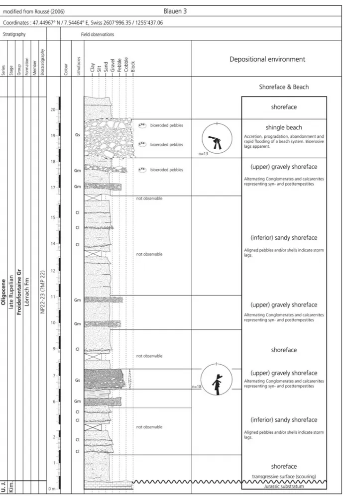
Similar to the conglomeratic Turckheim Fm the Lörrach Fm was deposited along the south-ern URG margins. Occurrences are much more scattered though, with outcrops near Eguisheim (Alsace) and from the Ajoie (Switzerland) to Lörrach (Germany). A thickness of at least 20 m is reached in the Blauen 3 section (Roussé 2006; Fig. 16). Wittmann (1949) and Fischer (1965a) report a thickness of maximal 30 m for the area of Lörrach and Wolschwiller.
6.5.3 Type, reference and classic localities
In Baden-Württemberg equivalent sediments have been designated as Lörrach Fm (LGRB 2011;
Pirkenseer C., Rauber G. & Roussé S.
188
Fig. 19 - Type section of the Près Roses Mb near Delémont (Switzerland) based on historical outcrops in Liniger (1925). For other occurrences of the member see Fig. 10-12.
GeORG 2013), with well-documented localities concentrated around Lörrach (Wittmann 1951; 1952, 1967; Fischer et al. 1971). Though a formal type section is still being evaluated, we adapt this lithostratigraphic term and provide reference pro-files.
In the research area Bitterli (1945) investi-gated the former Kleinblauen quarry section in detail, including an extensive fossil list. Roussé (2006) carried out an exhaustive sedimentary analysis (p. 111-146) of outcrops in the Dornach-Blauen-Burg-Biederthal-area and subdivided the formation in 4 facies types. The sections Burg-Biederthal (47.46463° N / 7.44385° E) and Blauen 3 (47.44968°N / 7.54462° E) represent the lith-ological diversity of the formation and provide the most extensive outcrops and accordingly have been designated as reference sections (Fig. 16-17). Further outcrops at Kleinblauen, Dornach and Dürrmattgraben lie close to the northernmost an-ticlines of the folded Jura (Fischer 1965a; Roussé 2006). An overview of (former) outcrops in the Delémont and Ajoie subbasins is given in Liniger (1925) and Schneider (1960).
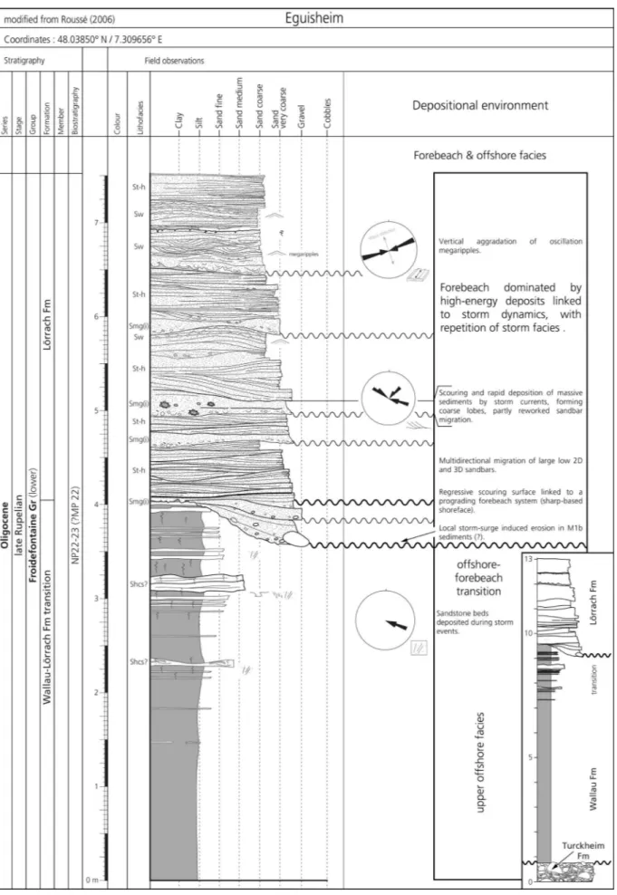
The section in the abandoned sand pit Eguisheim (Fig. 18) at the base of the Vosges foothills near Colmar (Alsace; 48.03850° N / 7.309656° E) illustrates the interfingering of the coastal Lörrach Fm with the basinal Wallau Fm (see 6.7).
6.5.4 Differentiation from other units
The Lörrach Fm is distinguished from coeval sediments (Wallau, Hochberg, Pulversheim Fms; see 6.7-6.9) by its much coarser grain size, com-mon occurrence of coastal marine macrofossils, sedimentary structures and beige colour. A transi-tional zone exists between these coeval formations (e.g. Fischer 1965a). A vertical transition is record-ed at the locality Eguisheim (Fig. 18), where at the base of the section passes from (microfossil-rich) offshore marls of the Wallau Fm within 4 m to an increasingly sandy lower shoreface environment (Pirkenseer et al. 2010; Pirkenseer & Berger 2011). They are erosively overlain by coarse-grained up-per shoreface sands (Roussé 2006). An oscillat-ing short-term trangressive-regressive pattern has been observed in shoreface to beachface sedi-ments of the equivalent Alzey Fm in the Mainz Basin (Roussé et al. 2012), which may hint at
sim-ilar transitions in a slightly more offshore position at Eguisheim.
From the older Turckheim Fm the Lörrach Fm is separated by the difference in color (ochre vs. red) and sedimentary structures (beach front vs. fan-delta). The Lörrach Fm generally lies ero-sively on Jurassic carbonates, but in some localities the conglomerates of the Turckheim Fm form the underlying stratigraphic unit (e.g. at Eguisheim, see inset Fig. 18).
The “Calcaires, grès et marnes jaunes à fossiles marins” sensu Gressly & Mayer (1853) and the equivalent “Gompholithe d’Ajoie” sensu Rollier (1910) belong mostly to the Lörrach Fm, since the Lörrach Fm includes deposits compara-ble in lithology and fauna. Liniger (1925) adopted the term “Gompholithe d’Ajoie” for conglomer-atic deposits in the Delémont subbasin. The latter are deposited on and include reworked marls of the underlying Rossemaison Fm. They are inter-preted within a “Meeressand / Cerithienkalk” con-text (as for the Ajoie), hence being equivalent to the coarse-grained facies of the Lörrach Fm sensu Roussé (2006). A similar coeval stratigraphic posi-tion of the “Gompholithe d’Ajoie” has been indi-cated by GeORG (2013).
6.5.5 Age and fossil content
It is difficult to pinpoint the age of the Lörrach Fm. In older literature the mollusc fauna has been correlated with adjacent areas (e.g. Mainz Basin), which is of little biostratigraphic value in view of modern standards.
For the equivalent Alzey Fm an absolute 87Sr/86Sr age of 30.1 (± 0.1) Ma and the attribution to calcareous nannoplankton zones upper NP23-lower NP24 has been cited in Grimm (2006). In the southern URG the coeval Wallau Fm adheres to the interval of planktic foraminifera zones mid O3 and end O4 (sensu Berggren & Pearson 2005) and calcareous nannoplankton zones NP23-24 (Pirkenseer et al. 2010). NP23 has been indicated for the Wallau Fm in the Mainz Basin (Grimm et al. 2011b).
Picot et al. (2008) correlate the initial transgressive sediments of the research area with somewhat older biozones (MP22, NP22-base23). The numerous pitfalls of biostratigraphic dating in the area (abundant reworked nannoplankton) has been outlined in Picot (2002) and is partly
Pirkenseer C., Rauber G. & Roussé S.
190
due to the uncertainty of the individual extent of calcareous nannoplankton zones NP22-24 (e.g. Vandenberghe et al. 2012). Since for the underlying Rossemaison Fm in the Delémont subbasin charophyte assemblages correlate with small mammal biozones MP20 and MP21 (Gander 2013), a transgression of the marine sequence in biozone MP22 is however not entirely implausible. In conclusion the initial late Rupelian flooding of the URG coincides roughly with the upper part of the transgressive system tract of the global Ru2 sequence.
Similar to the Alzey Fm of the Mainz Basin abundant and diverse shallow marine macrofauna may be present. Faunal lists of molluscs have been provided in older literature (e.g. Gressly & Mayer 1853; Sandberger 1863; Delbos & Köchlin-Schlumberger 1867; Greppin 1870; Kissling 1896; Kessler 1909; Wurz 1912; Liniger 1925; Wittmann 1952), since most historical outcrops are no longer accessible. Mammals (6 taxa), sharks (6), rays (1), bivalves (44) and gastropods (36) for the Kleinblauen reference area are listed in Bitterli (1945). Foraminifera have been analysed in thin sections therein. Foraminifer and ostracod taxa from the transitional facies between Lörrach and Wallau Fm at Eguisheim are listed in Pirkenseer et al. (2010) and Pirkenseer & Berger (2011).
6.6 P
rèsr
osesM
b(
PartIM ex-
cyathula-b
ank/M
ergel)
6.6.1 Synonomy
• banc à Ostrea cyathula (Greppin 1870)
• non Schicht mit Ostrea cyathula (Gutzwiller 1893)
• ?marne grise à dents de Lamna, ossement de Halitherium, Ostrea cyathula (Rollier 1910)
• Ostrea cyathula-Bank, Austernbank, partim Cyathulamergel
(Liniger 1925)
• non Ostrea cyathula-Bank (Koch 1923)
• non Cyathulabank (Baumberger 1927, Fischer 1965a) • Austernlumachelle [at Löwenburg] (Fischer 1965a) • partim Cyathulamergel (Picot 2002, Becker 2003, Picot et
al. 2008)
Fig. 20 - Overview sedimentary and gamma ray log of drilling DP-202 near Pulversheim (France), documenting the entire transgression-regression cycle of the late Rupelian marine ingression into the URG. Note the distinct peak designating the Hochberg Fm, the increase of the sand fraction in the lower Pulversheim Fm denoting a first deltaic progradation event and the final regression during the increasingly coarser clastic Wahlebach Fm.
Fig. 21 - Reference sections of the emended Wallau and Hochberg Fms in the neighbouring drillings DP-202 and DP-212 north of Mulhouse (France). Note the distinct changes in sediment colour, granulometry and stratification.
Pirkenseer C., Rauber G. & Roussé S.
192
6.6.2 Definition, distribution and thickness
A bed of densely packed complete or frag-mented oyster shells within a sandy to marly ma-trix, ranging in thickness from 0.1 to 2 m (Sorne section, Liniger 1925; Weidmann 1990). It is inter-preted as a lateral lagoonal member of the Lörrach Fm restricted to the Delémont subbasin. Thickness varies considerably in the area of deposition. The member transgresses bioerosively either directly on the underlying Rossemaison Fm (HRT-F8/9, 19.22 to 19.14 m / 22.85 to 22.25 m; COM-F5, 65.0 to 61.4 m), or is intercalated in the proximal extension of the Pulversheim (Près Roses, Sorne river) or Lörrach Fm (ridge near Develier; Liniger 1925).
6.6.3 Type, reference and classic localities
The log of the former mine shaft of Près Roses has been described in Liniger (1925) and is accordingly designated as type locality (Fig. 19). Only two surface outcrops were accessible in the past (Sorne river, Develier). The oyster-bearing, fossil-rich marls in levels 1800-2100 in outcrop Beuchille-Est section 19 (Picot et al. 2008) may be attributed to this member, but the entire succes-sion at Beuchille is tectonically disturbed. As ref-erence profiles we define the relevant parts of the COM-F5 and HRT-F8/F9 drill cores (Fig. 10-12).
6.6.4 Differentiation from other units
The Près Roses Mb is distinguished from other lithostratigraphic units as densely packed oyster coquina. It represents a distinct facies with-in the shallow marwith-ine context of the Lörrach Fm. For some time the supraregional oyster-bear-ing sediments were considered as coeval (e.g. Greppin 1870). This erroneous interpretation was however rectified by Gutzwiller (1893), who sep-arated the bed-like occurrences of oysters in the Delémont area from the so-called “Cyathulabank” s.s.. While the former are positioned at the base of the marine series of the Froidefontaine Group, the latter occur in the area south and west of Basel as a member of the younger Wahlebach Fm (Therwil Mb; see 6.12). Interpreting oysters as marker for a “shallow marine, partly brackish palaeoenviron-ment”, non-coeval oyster beds certainly represent-ed a recurring theme in the continuous context of the coastal marine depositional system of the mar-ginal Froidefontaine Group.
Liniger (1925) grouped the oyster bed(s) of the Delémont subbasin with the subsequent fos-sil-rich marls (only about 0.2 m thick) and termed the ensemble “Cyathulamergel”. Based on the abun-dant macrofauna (but absence of oysters) and the occurrence of quartz and glauconite grains these marls seem to represent a pinching out, shallower outlier of the Wallau Fm (see 6.7.2). More recent-ly the stratigraphic range of the “Cyathulamergel” has erroneously been extended and interpreted as an equivalent to the Hagenbach Mb (see 6.11; e.g. Picot et al. 2008).
Since only a very cursorily account of a cy-athula-bearing marl exists for a former outcrop near
Bonfol (Rollier 1910), its status as equivalent stra-tum in the Ajoie subbasin cannot be verified.
6.6.5 Age and fossil content
The Près Roses Mb has not been dated, but its age should be similar to its host formation.
Macrofossils are dominated by the oyster taxa
Crassostrea cyathula and C. callifera. Further marine
molluscs are listed in Liniger (1925). A prelimi-nary analysis confirmed the occurrence of shal-low marine Ostracoda (e.g. Cytheridea sandbergeri) in
drilling HRT-F8. The thin marls deposited directly on the oyster bed (see above) bear abundant ma-rine micro- and macrofauna (molluscs, shark teeth, Foraminifera, Ostracoda, crab claws; Liniger 1925; Picot et al. 2008).
6.7 w
allauf
M eMended(
ex-f
oraMInIferenMergel) (f
Ig. 13
b)
6.7.1 Synonomy and generalities
• partim terrain tertiaire marin (tongrien), marnes bleues (Delbos & Köchlin-Schlumberger 1867)
• partim Tongrien: facies vaseux (Greppin 1870)
• Mergel mit Ostrea callifera, Ostrea callifera-Mergel,
?Meeressandmergel (Andreae 1884, 1890) • Mergelfacies des Meeressandes (Andreae 1888)
• Marnes (molassiques) de Dannemarie, partim marnes bleues (Rollier 1893a, 1910)
• partim Septarienthon (Gutzwiller 1893, Rollier 1893a, 1910) • partim Meeressand (Gutzwiller 1914)
• ?partim Cyathulamergel, ?partim Septarienton (Liniger 1925)
• Marnes à foraminifères (Meyer 1928, Barbier 1938, Schnaebele 1948, Lagneau-Herenger 1965, Sittler 1965, 1992, Ménillet et al. 1970, Doebl et al. 1976, Duringer 1988, Roussé 2006, Pirkenseer et al. 2010, Pirkenseer & Berger 2011)
• Couches à foraminifères (Maïkovsky 1941)
• Foraminiferenmergel / Foraminiferen-Mergel (Förster 1909a, Vonderschmitt 1941, 1942, Bitterli 1945,