ADRIA AS PROMONTORY OF AFRICA AND ITS CONCEPTUAL ROLE IN THE TETHYS TWIST AND PANGEA B TO PANGEA A TRANSFORMATION IN THE PERMIAN
GIOVANNI MUTTONI1* & DENNIS V. KENT2
1 *Corresponding author. Dipartimento di Scienze della Terra 'Ardito Desio', Università degli Studi di Milano, via Mangiagalli 34, I-20133 Milan,
Italy.
2Earth and Planetary Sciences, Rutgers University, Piscataway, NJ 08854, USA, and Lamont-Doherty Earth Observatory of Columbia
University, Palisades, NY 10964, USA..
To cite this article: Muttoni G. & Kent D.V. (2019) - Adria as promontory of Africa and its conceptual role in the Tethys Twist and Pangea B to Pangea A Transformation in the Permian. Riv. It. Paleontol. Strat., 125(1): 249-269.
Abstract. It has been almost 60 years since the first results from the Early Permian Bolzano Quartz Porphyries
from the Trento Plateau of northern Italy (Southern Alps) showed paleomagnetic inclinations steeper than inclina-tions from broadly coeval units from central Europe. This experimental discrepancy, confirmed ever since at varying levels of magnitude and certitude, implied that northern Italy had paleolatitudes too northerly relative to Europe to be considered part of the European continent. On the other hand, it became progressively more apparent that paleo-magnetic data from northern Italy were more compatible with data from Africa than with data from Europe, and this observation revived and complemented Argand’s original concept of Adria as a promontory of Africa. But if Adria was part of Africa, then the paleolatitude anomaly of Adria relative to Europe translated into a huge crustal misfit of Gondwana relative to Laurasia when these landmasses were forced into a classic Wegenerian Pangea as typified by the Bullard fit of the circum-Atlantic continents. This crustal misfit between Gondwana and Laurasia was shown to persist in the ever-growing paleomagnetic database even when data from Adria were provisionally excluded as non-cratonic in nature. Various solutions were offered that ultimately involved placing Gondwana to the east (allowing it to be more northerly) relative to Laurasia and envisaging a dextral shear occurring in the Tethys (Mediterranean) realm between these supercontinental landmasses. This shear or transformation was initially thought to occur as a continuum
over the course of the Mesozoic–Cenozoic (the so-called ‘Tethys Twist’) but soon afterwards when plate tectonics came into play and limited the younger extent, as a discrete event during the post-Triassic, Triassic or most probably – as in the latest and preferred reconstructions – the Permian between a configuration of Pangea termed B – with the northwestern margin of Africa against southern Europe – to a configuration termed Pangea A-2, with the northwe-stern margin of Africa against eanorthwe-stern North America, that is more proximal in shape to the classic Pangea A-1 that started fragmenting in the Jurassic with the opening of the Atlantic Ocean. The Permian timing and presumed locus of the ~2300 km dextral shear is supported by rotated tectonic domains in Sardinia and elsewhere along the interface between Lauarasia and Gondwana. The concept of Pangea B and its transformation into Pangea A developed there-fore in close conjunction with the concept and paleomagnetic support of Adria as a promontory of Africa, and has ramifications to many aspects of tectonics, climate change and biogeography yet to be explored.
Received: February 05, 2019; accepted: March 12, 2019 Keywords: Paleomagnetism; Adria; Pangea B; Pangea A.
I
ntroductIonWe argue that the most reliable paleomagne-tic data point to a major albeit contentious tectonic change in the Permian (Gallo et al. 2017; Muttoni et al. 2009a): the transformation of the pole-to-pole supercontinent of Pangea from a ‘B’
configura-tion (Irving 1977; Morel & Irving 1981), with the northwestern margin of South America adjacent to eastern North America in the Early Permian, to the classic pre-drift Pangea A-1 or A-2 configuration (Bullard et al. 1965; Van der Voo & French 1974), with the northwestern margin of Africa now against eastern North America in the Late Permian. The tightly age-constrained transformation of Pangea B to a Pangea A configuration between ~275 and 260
Ma would have produced appropriately timed tec-tonic rotations about local vertical axes along a long dextral shear zone between Laurasia and Gondwa-na and affected land-sea distribution in the critical tropical humid belt, and hence continental silicate weathering, that may eventually be more precisely gauged as a contributing forcing to the demise of the Late Paleozoic Ice Age.
Here we offer a review of the critical role of Adria, the long presumed (and still debated) pro-montory of Africa (Argand 1922), as the source of key paleomagnetic data that first led to the concept of the ‘Tethys Twist’ by the Dutch school (Van Hilten 1964; DeBoer 1965) to its increasing mo-dern role (Channell & Horvath 1976; Channell et al. 1979; Lowrie 1986; Channell 1996; Muttoni et al. 2001) in support of the concept of Pangea B (Irving 1977; Morel & Irving 1981) and its tran-sformation during the Permian to a Pangea A-type configuration (Muttoni et al. 1996; 2003; 2009a). We begin with an historical overview of the debate that since the early 1960’s has concerned the con-figuration of Pangea in the Permo-Triassic, with Adria as a central locus of relevant paleomagne-tic data. We then proceed to discuss and discard interpretations of the data that infer a quasi-static Pangea A in the Permo-Triassic, and conclude by summarizing various predictions of the Pangea B to Pangea A Permian transformation hypothesis that are not nearly as well explain by a more or less static Pangea A configuration in the Late Paleozoic.
P
angeaB
toP
angeaa
t
ransformationOrigin of the idea: Adria and the ‘Tethys Twist’
The concept of Pangea B and its transfor-mation to the classic Pangea A (as typified by the Bullard et al. 1965 fit of the Atlantic-bordering continents) is deeply rooted in the rise of paleoma-gnetism as a discipline to demonstrate continental drift and the advent of modern plate tectonics (see Irving 2004, 2005, 2006 for reviews) and evolved in close relationship with the concept of Adria as a promontory of Africa, first put forward by Ar-gand (1922). A specific region and a specific rock type played a fundamental role in the mutually in-fluencing Adria and Pangea B concepts: the
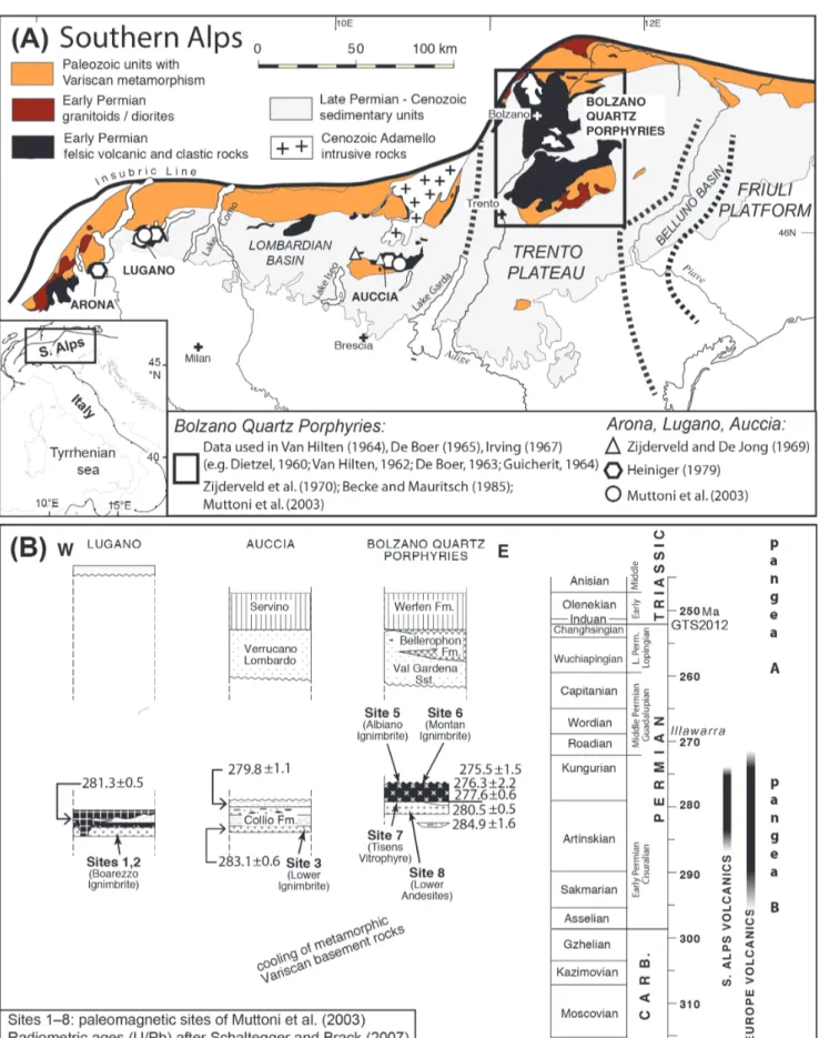
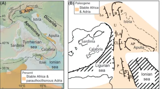
Sou-thern Italian Alps, particularly their least deformed northeastern sector comprising the Trento Plateau with the majestic Dolomites (Fig. 1A), where the products of the Early Permian volcanic cycle crop out in three main provinces informally termed Arona-Lugano, Auccia, and Bolzano (Fig. 1A), and are provided with modern U/Pb ages of ~285– 275 Ma (Schaltegger & Brack 2007) (Fig. 1B). It has been shown since the 1960’s (e.g., Van Hilten 1964; De Boer 1965; Schwarz 1965; Zijderveld et al. 1970) that paleomagnetic data from the Early Per-mian Bolzano Quartz Porphyries from the Tren-to Plateau (Fig. 1A), studied for paleomagnetism since Dietzel (1960), Van Hilten (1962), De Boer (1963), and Guicherit (1964), better agree with the available record from nearly contemporaneous rock units in Africa than with that of Europe. This dichotomy of agreements is at the foundation of the modern concept of parauthocthonous Adria as a promontory of Africa. Parauthocthonous Adria is comprised of regions of the present-day Italian peninsula – for example the Trento Plateau in the Southern Alps (Fig. 1A) – that are characterized – generally speaking – by a Variscan crystalline base-ment overlain by non-metamorphic and relatively mildly deformed Permo–Cenozoic sedimentary and volcanic units that yielded paleomagnetic data statistically indistinguishable from data from cra-tonic Africa and Gondwana (Channell & Horvath 1976; Channell et al. 1979; Lowrie 1986; Channell 1996; Muttoni et al. 1996, 2001, 2003, 2013). In ge-neral, Adria is a term applied to the mildly defor-med Po-Adriatic foreland basin rimdefor-med by three orogens: the Alps, the Apennines, and the Dina-rides (Channell et al. 1979), and bounded by the Plio-Pleistocene Tyrrhenian Sea (Chiarabba et al. 2008) in the west and the much older (Triassic?) Ionian Sea (Speranza et al. 2012) in the southeast (Fig. 2A). An indicative paleogeography of Adria in the Paleogene, before main Alpine and Apennine tectonics, is illustrated in Figure 2B where Adria is depicted as a set of platforms and basins on continental crust protruding from Africa (Muttoni et al., 2001). Bosellini (2002) reviewed geological, paleontological and paleoecological-straigraphic data from Adria and concluded that ‘Adria was an African Promontory and the Apulia Platform was (…) a sort of Florida Peninsula, subdividing the ‘‘Mesozoic Mediterranean’’ into a western Ionian basin and an eastern Levantine basin’ (see Figure
Fig. 1 - A) Geologic sketch map of the Southern Alps with location of various sampling areas in Early Permian volcanic units discussed in the text. The paleogeographic domains of the Trento Plateau and surrounding Lombardian and Belluno basins and Friuli Platform are also indicated (for these paleogeographic units, see also Figure 2). Modified from Muttoni et al. (2003). B) Chronology of Early Permian volcanics from the Southern Alps (see Fig. 1A for locations) that were sampled for paleomagnetism by Muttoni et al. (2003) finding support for Pangea B in the Early Permian. These volcanics are overlain by sediments that support Pangea A (Muttoni et al. 2003). The chronology is erected on U/Pb data from Schaltegger and Brack (2007). Figure modified from Schaltegger and Brack (2007) and adapted to the Geological Time Scale 2012 (GTS2012).
17 in Bosellini 2002).
Some of the same paleomagnetists who first pointed out the Adria-Africa connection (Van Hil-ten 1964; De Boer 1965; Schwarz 1965; Irving 1967) showed also that the paleomagnetic inclinations of these Early Permian Bolzano volcanics from the Trento Plateau of Adria – and hence their paleo-latitude of formation via the geocentric axial dipo-le (GAD) hypothesis – are invariably higher than those from broadly coeval units from Europe. This implies that if Africa – with Adria attached – and Europe were to be reconstructed in their present re-lative longitudes in a Pangea A configuration accor-ding to something like the Bullard et al. (1965) fit, a considerable – and geologically untenable – crustal overlap between the northern and southern conti-nents would result. Solutions to this paleomagnetic inclination discrepancy involved shifting the sou-thern continents of Gondwana to the east relative to the northern continents of Laurasia (Van Hilten 1964), and envisaging a dextral transformation to progressively bring them to their present relative longitudes. This translation was termed the ‘Tethys Twist’ by Van Hilten (1964) because the shearing between Gondwana and Laurasia occurred in the Tethys belt, as described in more detail below.
Van Hilten (1964) used paleomagnetic data from various continents including data from the non-cratonic ‘Alpine Tethys’ of southern Europe, e.g. the Early Permian Bolzano Quartz Porphyries from the Trento Plateau (Fig. 1A), and was among the first to recognize a Permian paleomagnetic-ba-sed paleogeographic assembly of Gondwana and Laurasia very different from the canonic
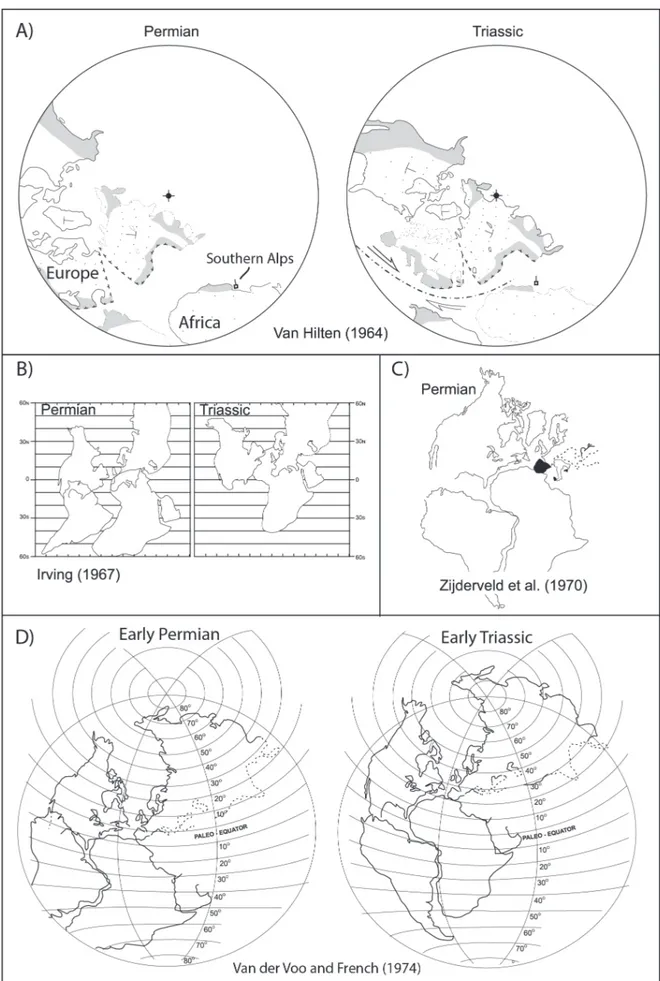
Wegene-rian (Pangea A-type) assembly. He stated: ‘It is em-phasized that it is not possible to collect all conti-nents into single assemblage, usually called Pangaea; anyway not in the arrangement proposed originally by Wegener (…) The paleomagnetic data do not al-low such a arrangement during the late Paleozoic and early Mesozoic (…)’. Van Hilten (1964) propo-sed an arrangement of Gondwana and Laurasia in the Permian closer to what Irving (1977) eventually referred to as Pangea B, and proposed a continuous translation of the two supercontinents, called the ‘Tethys Twist’, from the Permian to the Alpine oro-geny in the Cenozoic. This protracted timing was eventually rejected when it was realized that the Al-pine orogeny was rather the result of Africa-Euro-pe convergence from the oAfrica-Euro-pening of the Southern Atlantic in the Cretaceous (e.g., Dewey et al. 1973). But as pointed out by Irving (2004) in his histori-cal overview, ‘…one notable feature of Van Hilten’s maps has endured: his placement of Italy jutting out from what is now Tunisia’. This placement repre-sents the beginning of the modern concept of pa-rauthocthonous Adria as a promontory of Africa, as summarized by Van Hilten's (1964): ‘(…) a very surprising fact can be observed now: the southern Alps can be attached to the African continent from the Permian on, keeping perfectly their position and orientation with respect to this continent during all the Mesozoic (…)’. It should be noted that in Van Hilten (1964) maps, the Southern Alps are depicted by a square symbol located off Tunisia and are not part of Italy (Fig. 3A).
De Boer (1965) (working in Utrecht) used pa-leomagnetic data from stable Europe and the ‘Alpi-Fig. 2 - A) The present setting of the
Italian peninsula with indication of areas considered parauthoc-thonous relative to Africa. B) Tentative model of Adria as a promontory of Africa in the Pa-leogene (~50 Ma), with broadly continuous north-south struc-tural trends from Tunisia to the Southern Alps. AP = Apulia-Gargano platform, B = Belluno basin, CL = Campano-Lucana platform, F = Friuli-Istria plat-form, IB = Iblei platplat-form, IS = Imerese-Sicani basins, L = Lagonegro basin, LA = Lazia-le-Abruzzese platform, Lo = Lombard basin, P = Panormide platform, T = Trento Plateau, U = Umbria-Marche basin. Modi-fied from Muttoni et al. (2001).
ne Tethys’ of southern Europe, including data from northern Italy (e. g., the Early Permian Bolzano Quartz Porphyries studied earlier by Dietzel 1960; De Boer 1963; Guicherit 1964), and reached con-clusions similar to Van Hilten’s (working in Delft): ‘The deviation of the inclination of the paleoma-gnetic directions may be explained by assuming that the structural units of Italy, southern France, and Spain have moved westward with respect to meso-Europe. This late Paleozoic, Mesozoic, and Ceno-zoic westward drift of rigid blocks in the mobile Tethys zone is considered to be due to dextral shear movements, which developed in the Tethys zone during the northwestward drift of the Gondwana shields (Africa, Arabia, and India) and the contem-poraneous eastward movement of meso-Europe’ and that the ‘main conclusion drawn from the pa-leomagnetic data is that the Tethys mobile belt was and still is a zone of primary dextral shear’. Howe-ver, De Boer (1965) did not use Van Hilten’s term ‘Tethys Twist’ to describe the prolonged (Permian to Cenozoic) shear in the Tethys. Independently, Schwarz (1965) made a statistical analysis of the in-clinations from the ‘Alpine Tethys’ realm and nor-thern Europe and showed the differences between them to be systematic.
Irving’s paper in 1967 (titled ‘Palaeomagnetic evidence for shear along the Tethys’) followed in the footsteps of Van Hilten (1964) and De Boer (1965). Irving used paleomagnetic data from undeformed regions of Africa, North America, South America, and Australia and observed crustal overlaps of up to ~1000 km between the reassembled northern and southern continents of Gondwana and Laura-sia if they were to remain in their present relative longitudes in the Permian and Triassic (Fig. 3B). He also reviewed the extensive Permian to Cretaceous database from the ‘Alpine Tethys’ realm including northern Italy as well as Spain, France, and Austria, in conjunction with data from former Czechoslova-kia and the USSR and elsewhere, e.g., Turkey, Japan, and China, and stressed that ‘latitudes calculated for deformed regions within the Tethys are inconsistent with those calculated for their present borderlands’. For example, the Permian paleolatitude of Irving’s ‘Venezia Tridentina’ – or northeastern Italy – is far to the north relative to an Italian peninsula conside-red part of the European continent. Irving (1967) was evidently not an advocate of northern Italy (Adria) as part of Africa, as Van Hilten (1964) was,
because he placed ‘Venezia Tridentina’ to the east of Europe (to resolve the paleolatitude mismatch) but not close to western Africa, where it should be according to the Adria promontory concept (see Figure 2 in Irving 1967). In any case, one way that Irving found to explain the paleolatitude inconsi-stencies between regions within the ‘Alpine Tethys’ and those calculated for their present borderlands ‘is to suppose that the northern and southern con-tinents have since undergone relative longitudinal movements, the Tethys being the shear zone betwe-en them.’ He also added that the ‘time of these po-stulated motions is not closely defined. They were post-Triassic and appear to have been completed by the late Tertiary’. Hence Irving (1967) reached con-clusions similar to those of Van Hilten (1964) and De Boer (1965) at least in reaffirming the paleolati-tude ‘anomaly’ of data from the ‘Alpine Tethys’, e.g. of northern Italy, and stressing the crustal misfit of Gondwana and Laurasia in a standard Pangea con-figuration that was however (and mistakenly in our view) extended well after the Late Paleozoic.
Zijderveld et al. (1970) reported new results from the Early Permian Bolzano Quartz Porphy-ries from the Trento Plateau for comparison to an updated review of Permian data from Europe. What came out of their analysis was a clear endor-sement for parauthocthonous Adria as a promon-tory of Africa: ‘(s)ince the paleomagnetic direction of the Early Permian volcanics of the Southern Alps fits in reasonably well with the (poorly known) Early Permian paleomagnetic pattern of Africa, a coherence between both regions is presumed’, im-plying ‘for the Southern Alps an original position somewhere in the Western Mediterranean area, not far from its present position’ and consequen-tly ‘hardly any relative movements with respect to Africa…’. However, the paleomagnetic inclination discrepancy between the Trento Plateau and Euro-pe at the basis of the ‘Tethys Twist’ concept, which was on the order of ~20° or more at the times of Van Hilten (1964, Fig. 4), was reduced (but not com-pletely eliminated) to less than 10° for Zijderveld et al. (1970, Fig. 8) as their new data from the Bolza-no Quartz Porphyries and from Europe (Zijderveld 1967) became available. This reduction (but not eli-mination) of discrepancy allowed these authors to propose an alternative reconstruction in which they ‘squeezed’ Gondwana and Laurasia into Pangea A similar to the classic and cited Bullard et al. (1965)
Fig. 3 - Permian–Triassic paleogeographies according to A) Van Hilten (1964), B) Irving (1967), C) Zijderveld et al. (1970), and D) Van der Voo and French (1974). See text for discussion.
fit (Fig. 3C). Interestingly, however, Zijderveld et al. (1970) did not rule out altogether the Permian ‘Pan-gea B-like’ reconstruction of the Atlantic-bordering continents of Van Hilten (1964) and Irving (1967) (see Zijderveld et al. 1970, Fig. 11) because the avai-lable paleomagnetic data alone did not allow them to make a definitive choice: the discrepancy, although reduced, was still there. A decision to lean in favor of Pangea A for the Permian did not come from pa-leomagnetism but from their considerations regar-ding the structure of the Atlantic Ocean floor.
Four years later, Van der Voo and French (1974) took the skeptical view of Zijderveld et al. (1970) against a mobile Pangea in the Permian to a further level by presenting a compilation of paleo-magnetic poles from five continental plates (North America, Europe, the Iberian Peninsula, Africa, and South America) for ten time intervals ranging from Late Carboniferous to Eocene. These authors dismissed altogether – and with little explanation – data from Adria (e.g., Trento Plateau) used by Van Hilten (1964), De Boer (1965), and Irving (1967) to infer shear in the Tethys, yet they still found a clear discrepancy of Gondwana and Laurasia paleopoles when continents are repositioned in a Pangea A con-figuration in the Permian: ‘… the fit of the conti-nents by Bullard et al. (1965) cannot be used for this period. Van Hilten (1964) did note this possibility and proposed an alternative continental reconstruc-tion, implying subsequent dextral shear in the Tethys zone: the Tethys twist. Since then so many data have become available that the Tethys twist concept is no longer tenable’. Some of the discrepancy between Gondwana (without Adria) and Laurasia data in the Permian was resolved by proposing a modified ver-sion of the Bullard et al. (1965) fit in which Gon-dwana was restoratively rotated ~20° clockwise rela-tive to Laurasia about a pivot point in the southern Sahara. This very tight Pangea A – that will become termed Pangea A-2 by Morel and Irving (1981) – was thought to be valid from Late Carboniferous throu-gh Late Permian times (Fig. 3D). The authors infer that the corresponding dynamic counterclockwise rotation of ~20° from Pangea A-2 to a configura-tion similar to that proposed by Bullard et al. (1965) (that Morel and Irving (1981) termed Pangea A-1), started in the latest Permian/Early Triassic and was completed in the Late Triassic (Fig. 3D) (see also Van der Voo, 1993 for a discussion on Pangea A-1 and A-2).
To summarize, the 1960’s and early 1970’s saw a central role of paleomagnetic data from nor-thern Italy (e.g., Early Permian Bolzano Quartz Porphyries from the Trento Plateau) and elsewhere in the ‘Alpine Tethys’ of southern Europe in re-vealing systematic inclination (paleolatitude) in-congruences with coeval data from central Europe (Van Hilten 1964; De Boer 1965; Irving 1967 and even Zijderveld et al. 1970, who considered the mi-sfit minimal). Van Hilten (1964) pointed out that data from northern Italy were consistent with data from Africa, and in our opinion he can be conside-red the founder of the modern (after Argand 1922) concept of Adria as a promontory of Africa, which has been developed since with the progressive ac-quisition of new data (Channell & Horvath 1976; Channell et al. 1979; Lowrie 1986; Channell 1996; Muttoni et al. 2001, 1996, 2003, 2013; see also be-low). Van Hilten (1964) used data from the main continents including Adria (e.g., Trento Plateau of northern Italy) to infer the occurrence of a cru-stal misfit of Africa and Europe if reconstructed in present-day relative longitudes according to so-mething like the Bullard et al. (1965) fit (now ferred to as Pangea A-1). The conundrum was re-solved by placing Gondwana to the east relative to Laurasia by variable amounts of up to ~5000 km and by envisaging a prolonged (~Permian–Ceno-zoic) dextral shear of Gondwana relative to Lau-rasia – Van Hilten’s (1964) ‘Tethys Twist’ – that brought global paleogeography toward its modern configuration. Irving (1967) confirmed the exi-stence of an ‘anomaly’ in the paleolatitudes of the ‘Alpine Tethys’ of southern Europe (e.g., northern Italy) relative to those of central Europe. He was no advocate of Adria as a promontory of Africa and he did not place northern Italy close to western Africa, as Van Hilten (1964) did, yet by reviewing data from the main continents he confirmed Van Hilten’s view of Gondwana displaced to the east relative to Laurasia. Zijderveld et al. (1970) retained the African promontory concept and confirmed the African congruence of data from northern Italy (Adria) pointed out by Van Hilten (1964), but then took a skeptical view of the highly mobilistic inferences put forward by Van Hilten (1964), De Boer (1965) and Irving (1967), and considered the inclination (paleolatitude) ‘anomaly’ between data from northern Italy (Adria) and Europe as suffi-ciently reduced to allow Gondwana and Laurasia to
be squeezed in a Pangea A configuration. Van der Voo and French (1974) did not confront the data from Adria and concluded in favor of a very tight Pangea A-2 in the Late Carboniferous–Permian (with a reduced crustal overlap between Gondwa-na and Laurasia in the Gulf of Mexico area) and a more canonic Bullard et al. (1965) Pangea A-1 in the Late Triassic.
Development of the idea: Early Permian Pangea B to Late Permian Pangea A
As paleomagnetic data continued to accumu-late, Irving (1977) published apparent polar wan-der (APW) paths for all major continents to wan-derive a set of global paleogeographic reconstructions from the Devonian to the Cenozoic. An innovation was to assign all studied poles (listed in the Ottawa Catalogs) a numerical geological age and average the poles in a moving time window (40 Myr for all but the youngest intervals and stepped 10 Myr in this analysis) for the APW paths. No data from Adria were used presumably because he excluded ‘results from deformed beds in foldbelts’. None-theless, when reconstructing the Variscan docking of Laurasia and Gondwana in the Carboniferous, he encountered the same old problem (after Van Hilten 1964; De Boer 1965; Irving 1967): a cru-stal misfit between Africa and Europe when recon-structed according to modern relative longitudes. He proposed a reconstruction where ‘Africa is op-posite Europe, and South America opop-posite North America’ (Fig. 4A), and officially termed this con-figuration ‘Pangaea B’. He also suggested that: ‘At the Permian-Triassic boundary the palaeomagneti-cally determined latitudes now allow Gondwana to rotate anticlockwise, and the transformation from Pangaea B to A to begin’. Hence, for Irving (1977), and subsequently for Morel and Irving (1981), the transformation occurred essentially in the Early Mesozoic (Triassic), well before the Cenozoic Alpi-ne orogeny, and was thus not the long, drawn-out Tethys twist of Van Hilten (1964).
A few years later, Van der Voo et al. (1984) reexamined critically the database used in Irving (1977) and Morel and Irving (1981), and even af-ter eliminating a substantial number of entries dee-med to have poor or questionable age control, they conceded that ‘both the Pangea A-2 and Pangea B fits are paleomagnetically permissible for the Late Carboniferous and Early Permian’. They further
stated that ‘(f)or the Late Permian, Irving’s Pangea B fits better suggesting that for that time either the Pangea A2 fit is less valid, or that the paleopoles and/or their ages are incorrect.’ Van der Voo et al. (1984) also made interesting considerations on the impact that different methods of APW path construction – based on running window (30 to 40 Myr) averages of paleopoles as in Irving (1977) or discrete time-slice (~15 Myr) averages as in Van der Voo et al. (1984) – can have on paleogeography and the Pangea debate in particular. In any case, it is of interest to note that even after critical scrutiny of data available at that time, Pangea B kicked back and remained viable.
The concept of Pangea B then remained essentially fallow until the publication of the pa-leomagnetism and tectonics textbook of Van der Voo (1993), which was skeptical of Pangea B but allowed Muttoni et al. (1996) to develop a regional strategy centered on an updated review of paleo-magnetic data from Laurasia, exploiting the excel-lent global pole database tabulated in Van der Voo’s book, and from Adria-northwest Africa (Western Gondwana), reviving and extending the Permian– Triassic database of northern Italy (Adria). Their main conclusions were: (1) confirmation of Ar-gand’s Adria as the Africa promontory, as ancho-red in extensive paleomagnetic data from Adria as reviewed by Channell (1996), which boosted the APW path database for West Gondwana (Africa with Adria, plus South America) for comparison with the APW path of Laurasia, (2) that the Early Permian mean paleopole for West Gondwana, in conjunction with the coeval Laurasia mean paleo-pole, support Pangea B of Irving (1977) and Morel and Irving (1981), (3) that the Late Permian/Early Triassic and the Middle Triassic/early Late Triassic paleopoles from Adria and Laurasia support Pan-gea A-2 of Van der Voo and French (1974), but only just after the transformation from Pangea B (Fig. 4B), (4) that the Tethyan megashear proba-bly occurred mainly during the Permian at the end of the Variscan orogeny (while our current view is that it occurred entirely after the Variscan orogeny; Muttoni et al., 2003), and (5) that the Late Triassic/ Early Jurassic paleopoles from West Gondwana and Laurasia agree with Pangea A-1 of Bullard et al. (1965), the widely accepted Pangea configura-tion at the time of its Jurassic breakup (Fig. 4B).
Fig. 4 - Permian–Triassic paleogeographies according to A) Irving (1977), B) Muttoni et al. (1996), and C) Muttoni et al. (2003). See text for discussion.
extended by Muttoni et al. (2003) with resampling of the Early Permian Bolzano Quartz Porphyries from the Trento Plateau as well as Early Permian volcanics in areas to the west of the Dolomites (Lu-gano, Auccia) (Fig. 1A), focusing on a few key lo-calities from these areas spread across most of the Southern Alps that were provided with radiometric (U/Pb) age constraints (anticipated in Muttoni et al., 2003, and published in Schaltegger and Brack, 2007) in a known structural and stratigraphic con-text (Fig. 1B). Muttoni et al. (2003) compared their results with data of Becke and Mauritsch (1984), Zijderveld et al. (1970), Zijderveld and De Jong (1969), and Heiniger (1979) from the same general areas (Fig. 1A) (see Table 1, entries #1-7), confir-ming what Heiniger (1979) already found about the general along-strike (W–E) coherence of the Sou-thern Alps, at least as far as these volcanic units are concerned. Muttoni et al. (2003) extended the com-parison to include also Early Permian data from northwest Africa in Morocco (Daly & Pozzi 1976; Westphal et al. 1979) (see Table 1, entries #8-9),
finding enough congruence with data from Adria to be able to construct an updated (after Muttoni et al. 1996) Early Permian Adria-northwest Africa overall mean pole (241.0°E, 41.4°N, A95 = 4.7°, N = 9). By comparing this Adria-Africa pole with a pole derived from averaging a total of 18 entries from Early Permian magmatic units from Europe (166.2°E, 42.2°N, A95 = 3.1°, N = 18) (see Table 1, entries #19-36), an offset similar to Pangea B was required to avoid crustal overlap with a standard GAD time-averaged field model.
Muttoni et al. (2003) also responded to a number of arguments that in the early 2000’s were variably invoked ‘to explain away the paleomagnetic evidence that has consistently resulted in a crustal misfit if a Pangea ‘A’ configuration is maintained in especially the Early Permian’, such as a departure from the standard GAD model of the time-avera-ged field whereby the crustal misfit at the basis of the Pangea B model is an artifact of an arbitrary large and persistent octupolar nondipole field (Van der Voo & Torsvik 2001; Torsvik & Van der Voo 2002) (which is precluded because data from Adria and Europe have similar low inclinations), or po-tential inclination error in sediments that may have produced paleolatitude artifacts and a misplacement of Gondwana relative to Laurasia (Rochette & Van-damme 2001) (which is precluded because the di-screpancy is also found in igneous data). Muttoni et al. (2003) concluded that neither a persistent zo-nal octupole field contribution nor inclination flat-tening in sediments can explain the paleomagnetic evidence for Pangea B in the Early Permian (Fig. 4C). They also added two important elements to the Pangea debate, that (1) according to their analysis the transformation from Pangea B to Pangea A occurred within the Permian and after the cooling of the Variscan basement (hence, it had little to do with the Variscan orogeny and should not be refer-red to as a late Variscan event), and (2) that the tran-sformation was closely associated with the opening of the Neotethys Ocean in the east between India/ Arabia and the Cimmerian microcontinents, hence linking the Permian transformation with the Neo-tethyan plate circuit.
Pangea B to A transformation during Neotethys opening
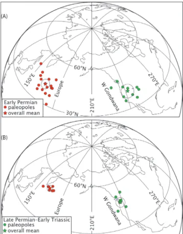
Connections between the Pangea B to A transformation, the opening of the Neotethys Fig. 5 - Early Permian (A) and Late Permian–Early Triassic (B)
pa-leomagnetic poles from Gondwana and Laurasia used by Muttoni et al. (2009a) for the paleogeographic reconstruc-tions of Pangea of Figure 6. See Table 1 for listing, Table 2 for mean poles, and text for discussion.
Ocean, and motions of Cimmerian terranes in the Permian were explored in more detail by Muttoni et al. (2009a; see also Muttoni et al. 2009b). In his
semi-nal work, Şengör (1979) proposed that a continental strip, termed the Cimmerian Continent, rifted from the northeastern margin of Gondwana – from
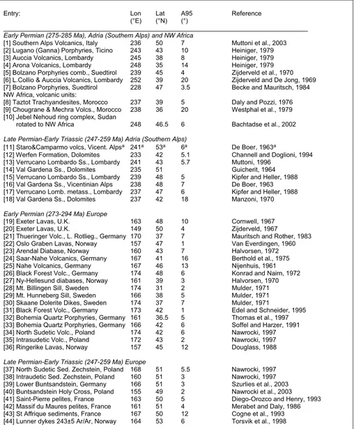
Entry: Lon Lat A95 Reference (°E) (°N) (°)
Early Permian (275-285 Ma), Adria (Southern Alps) and NW Africa
[1] Southern Alps Volcanics, Italy 236 50 7 Muttoni et al., 2003 [2] Lugano (Ganna) Porphyries, Ticino 243 43 10 Heiniger, 1979 [3] Auccia Volcanics, Lombardy 245 38 8 Heiniger, 1979 [4] Arona Volcanics, Lombardy 248 35 14 Heiniger, 1979 [5] Bolzano Porphyries comb., Suedtirol 239 45 4 Zijderveld et al., 1970 [6] L.Collio & Auccia Volcanics, Lombardy 252 39 20 Zijderveld and De Jong, 1969 [7] Bolzano Porphyries, Suedtirol 228 47 3.5 Becke and Mauritsch, 1984 NW Africa, volcanic units:
[8] Taztot Trachyandesites, Morocco 237 39 5 Daly and Pozzi, 1976 [9] Chougrane & Mechra Volcs., Morocco 238 36 20 Westphal et al., 1979 [10] Jebel Nehoud ring complex, Sudan
rotated to NW Africa 248 46.5 6 Bachtadse et al., 2002 Late Permian-Early Triassic (247-259 Ma) Adria (Southern Alps)
[11] Staro&Camparmo volcs, Vicent. Alpsa 241a 53a 6a De Boer, 1963a
[12] Werfen Formation, Dolomites 233 42 5.1 Channell and Doglioni, 1994 [13] Verrucano Lombardo Ss., Lombardy 241 43 5.7 Muttoni, 1996
[14] Val Gardena Ss., Dolomites 235 51 Guicherit, 1964 [15] Verrucano Lombardo Ss., Lombardy 239 48 5 Kipfer and Heller, 1988 [16] Val Gardena Ss., Vicentinian Alps 238 48 7 De Boer, 1963 [17] Verrucano Lomb. metass., Lombardy 237 47 6 Kipfer and Heller, 1988 [18] Val Gardena Ss., Dolomites 237 42 18 Manzoni, 1970 Early Permian (273-294 Ma) Europe
[19] Exeter Lavas, U.K. 163 48 10 Cornwell, 1967 [20] Exeter Lavas, U.K. 149 50 4 Zijderveld, 1967 [21] Thueringer Volc., L. Rotlieg., Germany 170 37 7 Mauritsch and Rother, 1983 [22] Oslo Graben Lavas, Norway 157 47 1 Van Everdingen, 1960 [23] Arendal Diabase, Norway 160 43 7 Halvorsen, 1972 [24] Saar-Nahe Volcanics, Germany 167 41 16 Berthold et al., 1975 [25] Nahe Volcanics, Germany 167 46 13 Nijenhuis, 1961 [26] Black Forest Volc., Germany 174 48 6 Konrad and Nairn, 1972 [27] Ny-Hellesund diabases, Norway 161 39 3 Halvorsen, 1970 [28] Mt. Billingen Sill, Sweden 174 31 2 Mulder, 1971 [29] Mt. Hunneberg Sill, Sweden 166 38 5 Mulder, 1971 [30] Skaane Dolerite Dikes, Sweden 174 37 7 Mulder, 1971
[31] Black Forest Volc., Germany 173 42 1 Edel and Schneider, 1995 [32] Bohemia Quartz Porphyries, Germany 161 36.5 5 Thomas et al., 1997 [33] Bohemia Quartz Porphyries, Germany 166 42 6 Soffel and Harzer, 1991 [34] North Sudetic Volc., Poland 174 42 6 Nawrocki, 1997 [35] Intrasudetic Volc., Poland 172 43 2 Nawrocki, 1997 [36] Ringerike Lavas, Norway 157 45 12 Douglass, 1988 Late Permian-Early Triassic (247-259 Ma) Europe
[37] North Sudetic Sed. Zechstein, Poland 168 51 5.5 Nawrocki, 1997 [38] Intraudetic Sed. Zechstein, Poland 160 51 3 Nawrocki, 1997 [39] Lower Buntsandstein, Germany 166 51 3 Szurlies et al., 2003 [40] Buntsandstein Holy Cross, Poland 155 49 2 Nawrocki et al., 2003 [41] Saint-Pierre pelites, France 163 50 5 Diego-Orozco and Henry, 1993 [42] Massif du Maures pelites, France 161 51 4 Merabet and Daly, 1986 [43] St Affrique sediments, France 167 50 12 Cogne et al., 1993 [44] Lunner dykes 243±5 Ar/Ar, Norway 164 53 6 Torsvik et al., 1998
Entry = paleopole entries used for mean paleopole determinations of Table 2. Paleopoles are given as longitude (Lon), latitude (Lat), and 95% confidence radius (A95).
a The area sampled by De Boer (1963) is known for Middle Triassic volcanism, so pending radiometric dating, this entry should be excluded from mean pole calculation, yielding a revised Late Permian-Early Triassic mean pole that is only 1° from the mean pole used by Muttoni et al. (2009a).
Tab. 1 - Early Permian and Late Per-mian-Early Triassic poles for Adria/Gondwana and Euro-pe/Laurasia used by Mutto-ni et al. (2009a) to calculate their mean poles as reported in Table 2.
Entry Geologic Age Range Lon Lat A95 K N D I Plat±A95
interval (Ma) (°E) (°N) (°) (°) (°) (°N)
Adria/Gondwana mean poles
[1-10] Early Permian 285-275a 242.0 41.4 4.4 122 10 324.1 17.1 8.8±4.4°
[11-18] L. Perm-E. Trias. 259-247b 237.6 46.8 3.1 317 8 329.7 22.5 11.7±3.1°
Europe/Laurasia mean poles
[19-36] Early Permian 294-273a 166.2 42.2 3.1 126 18 18.4 2.9 1.5±3.1°
[37-44] L. Perm-E. Trias. 259-247b 162.9 50.8 2.0 764 8 17.8 20.1 10.3±2.0°
Entry = paleopole entries from Table 1 used for mean paleopole determination. Age Range = numerical age ranges (Ma) of mean paleopoles according to (a) radiometric age constraints of volcanic units (see also Table 2 in Muttoni et al., 2003) and
(b) chronostratigraphic age of sediments according to the geologic timescale GTS2012. Mean paleopoles are given as
longitude (Lon), latitude (Lat), 95% confidence radius (A95), precision parameter (K) and number of poles used to calculate the Fisher mean (N). Projected directions at Bolzano (present coordinates: 46.5°N 11.35°E) calculated as declination (D), inclination (I) and paleolatitude (Plat) with associated A95 angle. Note that difference in projected paleolatitude in Early Permian is significant 7.3±5.4° (motivating Pangea B) but is insignificant 1.4±3.7° in the Late Permian-Early Triassic (allowing Pangea A).
Tab. 2 - Mean Early Permian and Late Permian-Early Triassic poles for Adria/Gondwa-na and Europe/Laurasia of Muttoni et al. (2009a) with projected directions and pa-leolatitudes of mean poles at Bolzano.
bia to Australia – during the Triassic to collide with the Eurasian southern margin in the Late Trias-sic–Middle Jurassic. The Neotethys Ocean was thus interpreted as a back-arc basin related to the south-ward subduction of the Paleotethys Ocean litho-sphere under the Cimmerian Continent in a static Pangea A geometry of Gondwana and Laurasia (see Fig. 2 in Şengör 1979). Muttoni et al. (2009a) pro-vided new Permian paleomagnetic data from Iran and Karakoram, putative parts of the Cimmerian Continent but which they referred to as Cimmerian terranes in deference to the possibility that Cimme-rian drifting could have taken more complex forms than those predicted by a single ‘ribbon continent’ sweeping across the Tethys in a ‘windshield wiper’ fashion. Samples from western Karakoram were collected years earlier by Maurizio Gaetani in a lat-eritic profile near the Lashkargaz village in Pakistan from within the Middle Permian Gharil Formation (Gaetani et al. 1995) pertaining to the Lashkargaz/ Baroghil tectonic unit (Gaetani et al 1996), whereas samples from Iran came from a lateritic profile near the Aruh village in the Alborz Mountains (see Mut-toni et al. 2009a for more details).
For reconstructing Gondwana in the Ear-ly Permian, Muttoni et al. (2009a) used the same paleopoles of Muttoni et al. (2003) from volca-nic units of Adria-Africa plus the paleopole from the Early Permian Jebel Nehoud ring complex of Sudan (Bachtadse et al. 2002), as summarized for reference in Table 1 (entries #1-10) and plotted in Figure 5A, that altogether yielded a volcanic-only overall mean pole at 242°E, 41.4°N (Table 2). For reconstructing Laurasia in the Early Permian, they used the same paleopoles of Muttoni et al. (2003) as listed in Table 1 (entries #19-36) and plotted in
Fig. 6 - On the left, Pangea evolution during the Permian accor-ding to Muttoni et al. (2009a). The Early Permian configu-ration is very similar to Irving’s (1977) Pangea B whereas the Late Permian–Early Triassic Pangea is similar to Pan-gea A-2 (Van der Voo and French, 1974; Morel and Irving, 1981). The Middle Permian Pangea was generated by line-ar interpolation of Eline-arly Permian and Late Permian–Eline-arly Triassic mean paleopoles of Gondwana and Laurasia (see Table 3 in Muttoni et al. 2009a). According to this sche-me, the transformation of Pangea B to Pangea A occurred within the Permian during the opening of the Neotethys Ocean and migration of Cimmerian terranes (Iran, Afgha-nistan, Karakorum, Qiangtang). Paleolatitude control points of Cimmerian terranes are from the Ruteh lavas from the Alborz region of north Iran (IR1; Besse et al. 1998), the Gharil ferricrete from the western Karakoram (KK; Mut-toni et al. (2009a), the Aruh ferricrete from the Alborz re-gion of north Iran (IR2; Muttoni et al. 2009a), the Hambast Formation from Abadeh in central Iran (IR3; Besse et al. 1998), the Hambast and Elikah formations from Abadeh in central Iran (IR4; Gallet et al. 2000), and the Tuoba For-mation from eastern Qiangtang (QT; Huang et al. 1992). Paleolatitude control points for Gondwana and Laurasia as part of Pangea are from the Kama region sediments com-bined (‘Kama’; Khramov 1982), the Thini Chu Group of Nepal (‘Thini Chu’; Klootwijk & Bingham 1980), and the Gerringong volcanics (Gerringong’; Irving & Parry 1963); the open circles associated with these error bars represent the paleolatitudes expected at these sites from the paleoge-ographic reconstruction. The green band centered on the equator in these reconstructions represents the area betwe-en about 5°S and 5°N of high temperature and humidity straddling the Intertropical Convergence Zone according to a standard climate zonality. (Manabe & Bryan 1985) Per-mian glaciations on Gondwana are indicatively reported. The right side of figure reports a schematic timescale for the Permian (GTS2012) with main Pangea events discussed in the text.
1
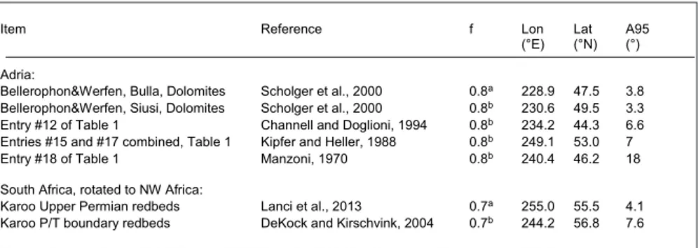
Item Reference f Lon Lat A95
(°E) (°N) (°)
Adria:
Bellerophon&Werfen, Bulla, Dolomites Scholger et al., 2000 0.8a 228.9 47.5 3.8 Bellerophon&Werfen, Siusi, Dolomites Scholger et al., 2000 0.8b 230.6 49.5 3.3 Entry #12 of Table 1 Channell and Doglioni, 1994 0.8b 234.2 44.3 6.6 Entries #15 and #17 combined, Table 1 Kipfer and Heller, 1988 0.8b 249.1 53.0 7 Entry #18 of Table 1 Manzoni, 1970 0.8b 240.4 46.2 18 South Africa, rotated to NW Africa:
Karoo Upper Permian redbeds Lanci et al., 2013 0.7a 255.0 55.5 4.1 Karoo P/T boundary redbeds DeKock and Kirschvink, 2004 0.7b 244.2 56.8 7.6 Mean paleopole: Lon = 239.7°E, Lat = 50.7°N, A95 = 5.8°, K = 109, N = 7 (Muttoni et al., 2013).
Arc distance with respect to Late Permian–Early Triassic mean paleopole of Muttoni et al. (2009a) based on entries 11-18 of Table 1 = 4°
f = flattening factor: a f calculated; b f assumed. Mean E/I corrected paleopoles are given as longitude (Lon), latitude (Lat), and 95% confidence radius (A95). See Muttoni et al. (2013) for further information.
Tab. 3 - Late Permian–Early Trias-sic poles from E/I cor-rected sedimentary units from Adria and South Africa (Gondwana) (Muttoni et al. 2013).
Figure 5A, that yielded a volcanic-only overall mean pole at 166.2°E, 42.2°N (Table 2). For reconstruct-ing Gondwana in the Late Permian–Early Triassic, Muttoni et al. (2009a) used paleopoles from Adria of Muttoni et al. (1996) (Table 1, entries #11-18; note caveat about #11), that are plotted in Figure 5B and that yielded a sedimentary-based overall mean pole at 237.6°E, 46.8°N (Table 2). Finally, for reconstructing Laurasia in the Late Permian–Early Triassic, Muttoni et al. (2009a) used paleopoles from sediments from Europe (Table 1, entries #37-44, plotted in Figure 5B), which gave a sediment-only overall mean pole at 162.9°E, 50.8°N (Table 2).
These paleopoles (Table 2) were used to generate the paleogeographic maps of Figure 6 (Muttoni et al. 2009a) where the Middle Permian reconstruction is based on an interpolation of the Early Permian and Late Permian–Early Triassic mean poles. Pangea B in the Early Permian is virtu-ally the same Pangea B of Muttoni et al. (2003) as it is based essentially on the same data, that impor-tantly are entirely from volcanic units for both Eu-rope/Laurasia and Adria/Africa (and hence not af-fected by inclination flattening that typically affects sediments), pertaining to the same (northern) hemi-sphere (hence less apt to be differentially affected by any persistent nondipole fields), and frequently provided with robust radiometric age estimates (es-pecially entries from the Southern Alps of Adria). The Late Permian–Early Triassic Pangea A (Fig. 6) is ironically entirely based on entries from sedi-ments for both Europe/Laurasia and Adria/Africa. Their age is inferred from stratigraphy (relative to the geologic timescale GTS2012: Gradstein et al. 2012), which especially in the case of entries from the Southern Alps, is relatively well established, placing these sediments uncomformably above the Early Permian volcanics (e.g. Bolzano Quartz Porphyries, see Fig. 1B). Inclination flattening is ex-pected for these sediments, but it is at present not possible to assess for all (Table 3; see discussion below) given the general lack of sufficient report-age of sample and site characteristic directions in these vintage studies. We notice in any case that all the entries are from the tropics of the northern hemisphere and hence less apt to be differentially affected by inclination flattening; for example, an average inclination flattening of, say, f = 0.8 or even 0.6, would result in a general northerly shift of both Gondwana and Laurasia by a few degrees. Besides,
data producing the crustal overlap invoking Pangea B is what inclination flattening has sometimes been called upon to explain, not a loose fit of Laurasia and Gondwana, as with the Late Permian-Early Tri-assic data, that allow a Pangea A-type configuration. When the Cimmerian terranes were placed on these Pangea reconstructions according to their paleomagnetically-derived paleolatitudes (IR1, IR2, IR3, IR4, Karakoram (KK), and Quingtang (QT), the terranes were found to have migrated from southern Gondwanan paleolatitudes in the Early Permian to subequatorial paleolatitudes by the Mid-dle Permian–Early Triassic (Fig. 6). Muttoni et al. (2009a) concluded that the ‘timing, rates, and geom-etry of Cimmerian tectonics are broadly compat-ible with the transformation of Pangea from a B to a A-type configuration with Neo-Tethyan opening taking place contemporaneously essentially in the Permian.’ Moreover, it appeared that the Neotethys Ocean may have opened asymmetrically during the Permian with terranes such as western Karakoram, central Afghanistan, and Qiangtang that appear to have moved faster in the Middle Permian compared to others such as Iran (and possibly also Sibumasu) that have been relatively steady in the Middle Perm-ian to then speed up in the Late PermPerm-ian–Early Tri-assic. Muttoni et al. (2009a) also outlined geologic evidence in favor of a northward subduction of the Paleotethys lithosphere under the Eurasian margin (instead of southward subduction under Cimmeria; Şengör 1979) and envisaged a grand scale scenario characterized by Neotethys opening, Paleotethys subduction, and Pangea B to A transformation oc-curring together in the Permian as part of an inter-nally consistent plate circuit.
s
ummaryandPresentviewsonP
ermianPaleogeograPhy
Pangea B remains a strongly debated issue. For example, Domeier et al. (2012) argued in their review that paleomagnetic data from the literature can be reconciled with Pangea A in the Early Perm-ian only barely without invoking non-dipole field contributions, but this conclusion was reached by excluding without circumstantial explanation — all data from Adria. In contrast, we maintain that con-temporaneous and more recent analyses provide strong evidence for a more mobile Pangea with
some interesting consequences, as itemized here: • Data from parauthocthonous Adria (e.g., the Trento Plateau in northern Italy) retrieved from radiometrically dated igneous rocks and/or bio-stratigraphically-dated sedimentary rocks provided with a direct assessment and correction of sedi-mentary inclination flattening (Tauxe & Kent 2004) have been shown to robustly agree with available data from Africa from the Early Permian to the Ce-nozoic (Muttoni et al. 2013). For the critical Early Permian period, Muttoni et al. (2013) reaffirmed the congruence of data from Adria, Morocco, and Sudan (Muttoni et al. 2009a) and extended compari-son to data from the 286±6 Ma Mount Leyshon Intrusive Complex and the Tuckers Igneous Com-plex of Australia that also supported Pangea B in the Early Permian (Clark & Lackie 2003). For the Triassic, a positive congruence test was obtained by targeting Middle Triassic rocks from northern Italy and northern Libya (Muttoni et al. 2001). An even more recent analysis reaffirmed the Adria-Africa congruence in the Jurassic–Early Cretaceous by stressing the remarkable coherence of data from Adria when reconstructed as part of northwest Af-rica to data from other plates reconstructed using independent plate circuits (North America, South America, Europe, southern Africa) in the Juras-sic–Early Cretaceous (Muttoni & Kent 2019) dur-ing and after the so-called Jurassic monster polar shift, a novel feature of global plate motion (Kent & Irving 2010; Kent et al. 2015). At the same time, the tectonic coherence of parauthoctonous Adria and Africa found support (or non-opposition) from Alpine plate kinematics arguments (Wortmann et al. 2001), and has substantially resisted attempts expressly directed to disprove it. For example, the alleged (although technically not significant) rota-tion of 9°±9° of parauthoctonous Adria relative to Africa (van Hinsbergen et al. 2014) was calculated without considering the effects of the large and rap-id Late Jurassic pole shift of Kent and Irving (2010) in making precise comparisons and needs therefore to be reconsidered. At present we can affirm that paleomagnetic data from parauthoctonous Adria, which according to Kent and Irving (2010) could not be used in APW path construction as in urgent need to be reassessed, have been reassessed, and we can also affirm that the road initially taken by Van Hilten (1964), the founder of the modern concept of Adria as a promontory of Africa, has been paved
with a wealth of reliable data that cannot be ignored (e.g., Domeier et al. 2012).
• Paleomagnetic data from volcanic rocks provided with radiometric and/or stratigraphic age constraints from parauthocthonous Adria-Africa (Gondwana) and Laurasia support Pangea B in the Early Permian (Muttoni et al. 1996, 2003, 2009a) (Fig. 6). An important factor in making intercon-tinental comparisons of paleomagnetic data has been improvements in radiometric dating and the age registry between sedimentary and igneous rock units. For example, studies through the 1980s typi-cally used the Van Eysinga (1975) geologic time scale, which placed the numerical age of the Perm-ian to between 231 Ma and 281 Ma whereas it has more recently been placed between ~252 and 299 Ma (e.g., Shen et al. 2013), a shift of ~20 Myr to old-er ages. Potential correlation problems with mixed igneous-sedimentary data were already regarded by Van der Voo et al. (1984) as the most critical consid-eration in evaluating Pangea reconstructions.
• For the bracketing Carboniferous and the Late Permian–Early Triassic, the global paleomag-netic database of poles from Gondwana and Laura-sia (e.g., Torsvik et al. 2012) is dominated by entries from sedimentary units frequently of early vintage and for which a direct assessment of inclination flat-tening is difficult to perform. Muttoni et al. (2013) attempted to estimate inclination flattening in Late Permian–Early Triassic data from Adria-Africa. They obtained a direct assessment of f = 0.8 for the Bellerophon and Werfen formations from the Bulla section in the Dolomites using data originally published by Scholger et al. (2000) (Table 3) as well as of f = 0.7 for the Karoo redbeds from South Af-rica originally published by Lanci et al. (2013) (Ta-ble 3). Flattening values for the other entries form-ing the Late Permian–Early Triassic Adria-Africa mean paleopole of Muttoni et al. (2013) (Table 3) were assumed using these estimates. With this ca-veat about data quality in mind, it seems ironic that some paleogeographic reconstructions show a Pan-gea B configuration in the Early Carboniferous yet a Pangea A configuration by the Permian (Fig. 18 and 19 in Torsvik et al. 2012), ostensibly requiring a large-scale dextral shear transformation from Pan-gea B to A in the Late Carboniferous. This seems no more nor less ‘critically lacking’ (Domeier et al. 2012) geological evidence than the major dextral shear between Laurasia and Gondwana, which in
our assessment more likely occurred in the Permian (Muttoni et al. 1996, 2003, 2009a).
• Additional research is required to assess in-clination flattening factors in Late Permian–Early Triassic sedimentary units from Gondwana and Laurasia (see above), but in any case, considering also inclination flattening-corrected paleopoles from Adria (Muttoni et al. 2013), there is no evidence that necessitates a Pangea B in the Late Permian or Triassic, as initially proposed by Irving (1977) (but see Irving 2004) and occasionally favored in some other studies (e.g., Torcq et al. 1997), nor has there been evidence for the long abandoned concept of a long continuum of transformation of Gondwana versus Laurasia as implied by Van Hilten’s Tethys twist model. Nonetheless, the deep root of Pangea B is with Van Hilten (1964) and its transformation to Pangea A resembles the Tethys twist albeit in a much narrower time frame.
• The precise timing of the post-Variscan transformation from Pangea B to Pangea A in the Permian (Muttoni et al. 1996, 2006, 2009a) is pres-ently difficult to set. Indicatively, it is younger than the age of the Early Permian volcanics of the Do-lomites in northern Italy dated with modern U-Pb radiometric techniques to 285–275 Ma (Shaltegger & Brack 2007; see also Visonà et al. 2007; Berra et al. 2014) and that provide paleomagnetic data sup-portive of Pangea B, and it is older than the age of the overlying Late Permian sediments that sup-port Pangea A (Muttoni et al. 2003) (Fig. 1B). These Late Permian sediments record polarity reversals, indicating an age no older than the Illawarra mixed polarity zone (end of Kiaman reverse polarity su-perchron) presently estimated at ~269 Ma (Lanci et al. 2013). Hence, the Pangea transformation appar-ently occurred between ~275 Ma and ~260 Ma or over a total of ~15 Myr. This represents a substan-tial revision of Irving’s (1977) original suggestion of a latest Carboniferous to Jurassic Pangea transi-tion, but which Şengör (2016) stressed that ‘Irving himself modified his original suggestion by indicat-ing that an early Permian (~280 Ma ago) Pangaea B had already become Pangaea A2 in the late Permian (~250 Ma ago)’ undoubtedly because Irving (2004) cited – and accepted – the Muttoni et al. (2003) analysis.
• The total amount of dextral shear required to accommodate the transformation occurring over ~15 Myr (between ~275 Ma and ~260 Ma) was on
the order of ~2300 km (Fig. 6), and hence consider-ably less than the ~3000 km originally proposed by Irving (1977). The shorter distance implies that the relative translation of Gondwana relative to Laura-sia occurred at ~15 cm/yr. This is within the nomi-nal speed limit of 18–20 cm/yr that the Indian plate set in the Cretaceous (Kumar et al. 2007).
• The transformation from Pangea B to Pan-gea A was linked with the opening of the Neote-thys and associated motions of Cimmerian terranes (Muttoni et al. 2009a). The concept of Pangea B and its transformation into Pangea A has been de-veloped independently from the concept of Cim-merian terranes and yet these concepts seem to be very much complementary when linked in a com-mon scenario of Neotethys opening, Paleotethys closure, motion of Cimmerian terranes and Pangea transformation occurring contemporaneously in the Permian as part of an internally consistent plate circuit.
• Finally, there is no need to abandon the geocentric axial dipole field model, which provides an excellent fit to the best available data from lava flows for the past 5 to 10 Ma (Opdyke et al. 2015; Cromwell 2018) and has served as a robust work-ing hypothesis for determinwork-ing paleolatitudes in virtually all paleogeographic reconstructions using paleomagnetic data. In fact, evidence for a Carbon-iferous–Early Permian Pangea B was obtained also by Gallo et al. (2017) in their novel approach involv-ing pure dipole analysis of Gondwanan data that, incidentally, did not include data from Adria.
f
uturer
esearchd
irectionsonP
angeaB
anditstransformationtoP
angeaa
Aside from obtaining additional paleomag-netic data with good age and tectonic control either from volcanic rocks or sedimentary units provided with inclination flattening assessments, especially from the facing continents of Africa and Eurasia, future research directions concerning the still-debat-ed Pangea paleogeography might delve into other aspects of tectonics, climate-sensitive biotic associa-tions, and even long-term climate change that could be explained better by the largely neglected Pangea B and its transformation to Pangea A in the Permian.
geological evidence for the major dextral shear between Laurasia and Gondwana required for the Pangea B to A transformation in fact may be repre-sented by a belt of rotated blocks in the Mediterra-nean region. Such a tectonically-active lineament is what was postulated by Van Hilten (1964) and De Boer (1965) and suggested as a test of the putative Tethys Shear by R.M. Shackleton, as quoted in Ir-ving (1967). This belt comprises tectonic blocks in southern France, Corsica, and Sardinia that variably rotated about vertical axes after the cooling of the Variscan basement and before the Late Permian-Triassic, entirely compatible with wrench faulting associated with intra-Pangea crustal instability and transformation during the Permian (Aubele et al. 2012, 2014; Bachtadse et al. 2018). Geological evi-dences of Permian dextral shear linked with Pan-gea transformation have also been proposed for the western Alps (Garde et al. 2015) and the Pyr-enees (Şengör 2013). These shear zones may spec-ulatively represent reactivations of Variscan shear zones sensu Arthaud and Matte (1977). The locus and timing of the local rotations and shear zones are essentially predictions of dextral shear in the transformation of Pangea B to A in the Permian, and are being borne out by the accumulating data.
Future research may also involve a better understanding of the timing of Neotethys open-ing and Cimmerian terrane motions as part of the grand-scale plate circuit involving Pangea transfor-mation. After the seminal work of Şengör (1979) on the drifting Cimmerian Continent, and the sparse paleomagnetic studies on Permian rocks from these Cimmerian terranes as outlined above, very little has been done for progress on this line of research. It appears that there is increas-ing agreement that the tectonic evolution of the eastern Tethys can accommodate Pangea B and its transformation to Pangea A in the Permian (e.g., Sengor 2006), and this will require reappraisal of tectonic scenarios that were based on a static Pan-gea A context.
There is also an intriguing coincidence that requires more attention between the post-Variscan transformation from Pangea B to A and the waning stages of the Late Paleozoic Ice Age (LPIA) that culminated with the demise of Alpine ice sheets in eastern Australia in the Late Permian (~260 Ma) (Metcalfe et al. 2015; Montañez & Poulsen 2013). Goddéris et al. (2017) suggested from their climate
and carbon cycling modeling that a topographi-cally-reduced Variscan equatorial mountain belt (whose rise may have helped initiate the LPIA in the Carboniferous) and more arid continental area from the assembly and drift of a supercontinent resulted in reduced silicate weathering and thus a higher net atmospheric CO2 concentration, which may have contributed to the termination of the LPIA in the Permian. However, their overall con-clusions relied on paleogeographic reconstructions that had an essentially static Pangea A configura-tion and paleolatitudinal posiconfigura-tion from the Early to the Late Permian (i.e., compare Figures 19 and 20 in cited Golonka 2002). In contrast, a mobilist tectonic model with a transformation from Pangea B in the Early Permian to a Pangea A configuration in the Late Permian should offer more possibilities for significant changes in tectonic boundary condi-tions that could have affected long-term climate. For example, the transformation of Pangea B to Pangea A would have reduced land-sea distribu-tion in the critical tropical humid belt, and hence continental silicate weathering, for a net increase in atmospheric greenhouse gases that might be linked as contributing to the demise of the LPIA (Kent & Muttoni 2019).
Finally, there have been hardly any analyses of biotic associations and paleogeographic distri-butions using an accurate Pangea B model for the Carboniferous-Early Permian. The few examples that show promise of further development include the work by Cisneros et al. (2012), who found sup-port for Pangea B when trying to account for the close phylogenetic relationship of South American and eastern European dinocephalians in the Perm-ian, and the work by Angiolini et al. (2007), who found that the distribution of climate-sensitive fos-sil biota, in particular, the warm-water Carbonif-erous-Permian biota of Iran and northern Arabia that are strikingly different from typical cold-water Gondwana associations, could be neatly explained when considered in the context of a Pangea B pa-leogeography.
Acknowledgements. Reviewer Massimo Mattei and the Editor
are thanked for insightful comments on an earlier version of this ma-nuscript. The authors wish to acknowledge the many contributions made by our recently departed colleague and good friend, Maurizio Gaetani, to our understanding of Alpine, Mediterranean, and Hima-layan geology. This is Lamont-Doherty contribution #8298.
references
Argand E. (1922) - La tectonique de l’Asie. Conférence faite á Bruxelles, le 10 août 1922, paper presented at Congrès géologique international (XIIIe session)-Belgique 1922. Arthaud F. & Matte P. (1977) - Late Paleozoic strike-slip
fault-ing in southern Europe and northern Africa: Result of a right-lateral shear zone between the Appalachians and the Urals. Geol. Soc. Am. Bull., 88: 1305-1320.
Angiolini L., Gaetani M., Muttoni G., Stephenson M.H. & Zanchi A. (2007) - Tethyan oceanic currents and climate gradients 300 m.y. ago. Geology, 35: 1071-1074.
Aubele K., Bachtadse V., Muttoni G., Ronchi A. & Durand M. (2012) - A paleomagnetic study of Permian and Trias-sic rocks from the Toulon-Cuers Basin, SE France: Evi-dence for intra-Pangea block rotations in the Permian.
Tectonics, 31(3): TC3015.
Aubele K., V. Bachtadse, V., Muttoni G. & Ronchi A. (2014) - Paleomagnetic data from Late Paleozoic dykes of Sar-dinia: Evidence for block rotations and implications for the intra-Pangea megashear system. Geochem. Geophys., Geosyst., 15(5): 1684-1697.
Bachtadse V., Zanglein R., Tait J. & Soffel H. (2002) - Pal-aeomagnetism of the Permo/Carboniferous (280 Ma) Jebel Nehoud ring complex, Kordofan, Central Sudan.
J. African Earth Sci., 35(1): 89-97.
Bachtadse V., Aubele K., Muttoni G., Ronchi A., Kirscher U. & Kent D.V. (2018) - New early Permian paleopoles from Sardinia confirm intra-Pangea mobility. Tectonophys-ics, 749: 21-34.
Becke M. & Mauritsch H. (1984) - Rock and paleomagnetic investigations on the Quartzporphyry Complex near Bolzano (Bozen), Italy. IGCP, Newsletter, 6: 11-19.
Berra F., Tiepolo M., Caironi V. & Siletto G.B. (2015) - U– Pb zircon geochronology of volcanic deposits from the Permian basin of the Orobic Alps (Southern Alps, Lombardy): chronostratigraphic and geological implica-tions. Geol. Mag., 152(3): 429-443.
Berthold G., Nairn A.E.M. & Negendank J.F.W. (1975) - A palaeomagnetic investigation of some of the igneous rocks of the Saar-Nahe Basin. N. Jb. Geol. Palaeont. Mh:
134-150.
Besse J., Torcq F., Gallet Y., Ricou L.E., Krystyn L. & Saidi A. (1998) - Late Permian to Late Triassic palaeomagnetic data from Iran: contraints on the migration of the Irani-an block through the TethyIrani-an OceIrani-an Irani-and initial destruc-tion of Pangea. Geophys. J. Int., 135(1): 77-92.
Bosellini A. (2002) - Dinosaurs ‘re-write’ the geodynamics of the eastern Mediterranean and the paleogeography of the Apulia Platform. Earth-Sci. Rev., 59: 211-234.
Bullard E.C., Everett J.E. & Smith A.G. (1965) - A sympo-sium on continental drift. IV. The fit of the continents around the Atlantic. Phil. Trans. Royal Soc. London, A258:
41-51.
Channell J.E.T. (1996) - Palaeomagnetism and palaeogeog-raphy of Adria. In: Morris A. & Tarling D.H. (Eds) - Palaeomagnetism and Tectonics of the Mediterranean
Region. Geol. Soc. Spec. Publ., London: 119-132.
Channell J.E.T. & Horvath F. (1976) - The African/Adriatic promontory as a palaeogeographical premise for Alpine orogeny and plate movements in the Carpatho-Balkan region. Tectonophysics, 35: 71-101.
Channell J.E.T., D’Argenio, B. & Horvath F. (1979) - Adria, the African promontory in Mesozoic Mediterranean pa-laeogeography. Earth Sci. Rev., 15: 213-292.
Channell J.E.T. & Doglioni C. (1994) - Early Triassic paleo-magnetic data from the Dolomites (Italy). Tectonics,
13(1): 157-166.
Chiarabba C., De Gori P. & Speranza F. (2008) - The south-ern Tyrrhenian subduction zone: deep geometry, mag-matism and Plio-Pleistocene evolution. Earth Planet. Sci. Letters, 268(3-4): 408-423.
Cisneros J.C., Abdala F., Atayman-Güven S., Rubidge B.S., Şengör A.C. & Schultz C.L. (2012) - Carnivorous dino-cephalian from the Middle Permian of Brazil and tet-rapod dispersal in Pangaea. Proc. Nat. Ac. Sci., 109(5):
1584-1588.
Clark D. & Lackie M. (2003) - Palaeomagnetism of the Early Permian Mount Leyshon intrusive complex and Tuckers igneous complex, North Queensland, Australia. Geophys. J. Intern., 153: 523-547.
Cogné J.P., Van Den Driessche J. & Brun J.P. (1993) - Syn-extension rotations in the Permian basin of St Affrique (Massif Central, France): paleomagnetic constraints.
Earth Planet. Sci. Letters, 115: 29-42.
Cornwell J. (1967) - Palaeomagnetism of the Exeter lavas, Devonshire. Geophys. J. Royal Astronom. Soc., 12(2):
181-196.
Corsini M. & Rolland Y. (2009) - Late evolution of the south-ern European Variscan belt: Exhumation of the lower crust in a context of oblique convergence. C R Geosci.,
341(2-3): 214-223.
Cromwell G., Johnson C.L., Tauxe L., Constable C.G. & Jar-boe N.A. (2018) - PSV10: A Global Data Set for 0–10 Ma Time-Averaged Field and Paleosecular Variation Studies. Geochem., Geophys., Geosys., 19: 1533-1558.
Crowell J.C. (1999) - Pre-Mesozoic Ice Ages: Their Bearing on Understanding the Climate System. Geol. Soc. America Memoir, 192: 1-106.
Daly L. & Pozzi J.-P. (1976) - Resultats paleomagnetiques du Permien inferieur et du Trias Marocain; comparaison avec les Donnees Africaines et Sud Americaines. Earth Planet. Sci. Letters, 29: 71-80.
De Kock M. & Kirschvink J. (2004) - Paleomagnetic con-straints on the Permian-Triassic boundary in terrestrial strata of the Karoo Supergroup, South Africa: implica-tions for causes of the end-Permian extinction event.
Gondwana Res., 7(1): 175-183.
Dietzel G.F.L. (1960) - Geology and permian paleomagnetism of the Merano region, province of Bolzano, N. Italy.
Geologica Ultraiectina, 4.
De Boer J. (1963) - The Geology of the Vicentinian Alps with special reference to their paleomagnetic history. Geologica Ultraiectina, 11.