ISSN 1828-5961
Rogério Palhares Zschaber de Araújo
Dottorato in Geografia - presso l’Univer-sità Federale di Minas Gerais – Brasile; Master in Community Planning presso l’Università di Rhode Island, Stati Uniti. Professore a Contratto - Facoltà di Archi-tettura e Urbanistica, UFMG (Università Federale di Minas Gerais). Planner della società Práxis Projetos e Consultoria Ltda. Coordinatore di lavori di urbanistica e studi ambientali, piani regolatori, analisi dell’impatto ambientale, disegno urbano e del paesaggio, sia per il settore pubblico che privato.
Il contributo descrive l’uso del GIS e di analisi multicriteria per definire capacità di addensa-mento e calcolare i limiti delle aree urbane nelle recenti esperienze di pianificazione regionale (il Regional Master Plan a Belo Horizonte, Brasile). Individua le aree da sviluppare o da densificare. Tratta la conservazione dell’ambiente e la tutela del territorio per progetti di edilizia residenziale sociale e per la concessione e l’attuazione degli strumenti previsti nello “Statuto della Città”. La combinazione di variabili è stata utilizzata per costruire l’analisi di rilevanza ambientale e le potenzialità di sviluppo degli indici che hanno costituito la base per la densificazione urbana e la tutela dell’ambiente e per la presentazione di scenari di pianificazione alternative. Sostiene il GIS e l’analisi multicriteria per evidenziare con-flitti socio-ambientali, di sostegno politico e di partecipazione nei processi decisionali, in base a
criteri tecnici e razionali, che coinvolgono diversi attori, con interessi nelle stesse aree.
Discusses the carrying capacity and calculate densification limits in urban areas to recent local planning experience, the regional master plans at Belo Horizonte, Brazil. Identifies areas to be developed or densified, areas for cultural and environmental preservation, land suitable for social housing projects, and for the allocation and implementation of urban planning instru-ments of Brazilian City Statute. Combination of variables was used to build up environmental relevance and development potential indexes, that can form the basis for urban densification and environmental protection categories, and to present alternative planning scenarios and pro-posals. Defends GIS and multicriteria analysis highlight socio-environmental conflicts and to
Valutare i limiti dello sviluppo e la capacità di carico in ambito urbano: note sull’uso dei Sistemi Di
Informazione Geografica e Analisi Multicriterio nella recente esperienza di pianificazione in Brasile
Assessing development limits and carrying capacity in urban environments: notes on the use of Geographic
Information Systems and Multicriteria Analysis in recent planning experience in Brazil
Parole chiave: capacità di carico; sviluppo urbano
e la densità; struttura urbana; metodi di analisi multicriterio in GIS
Keywords: carrying capacity; urban development
and density; inner urban structure; GIS multicriteria analysis methods
support political and participatory decision ma-king processes.
ISSN 1828-5961 Valutare i limiti dello sviluppo e la capacità di carico in ambito urbano 1. THE CONCEPT OF CARRYING CAPACITY
APPLIED TO URBAN ENVIRONMENTS
The concept of carrying capacity has its origin related to ecology, with regards to natural environments and the population of plants and animals. From this perspective, it refers to the maximum amount of individuals of a species that a given environment is able to keep in balance without affecting its basic needs for competition and reproduction such as food, light, water and space. The availability of these elements may stimulate or inhibit the development of a species beyond certain limits in a given habitat, varying within a certain interval and tending to a balance. The competition for food and space in an overpopulated habitat, for instance, frequently produces smaller and weaker individuals that reproduce less and the severe reduction of the population of a predatory species usually leads to environmental unbalances which are very difficult to overcome.
Although this concept, even within the limits of environmental sciences, is considered too reductive and only applicable to closed systems with little or no exchange with external environments, it is very commonly used through analogy in planning, especially for the definition of zoning categories that may be justified by ideal maximum population density breaks within different areas of a city.
Scientific researches involving the development of methods to measure the carrying capacity of urban areas tend to select natural environmental features (water, soils, climate, vegetation, etc.), infrastructure availability (roads and utilities, transportation networks, public services, urban amenities, etc.) and major impacts caused by urban development ( geological and flood hazards, pollution, effluent, erosion and sediment production, etc.) as variables to establish the conditions for possible urban development and densification; as well as for the definition of protected areas, being the main challenge the creation of combined indicators for the establishment of acceptable limits to the different situations that are meant to be generalized and controlled1.
Campos Filho (2003), for example, among other authors, identifies the road and transportation network as the main aspect to be evaluated as far as the carrying capacity of urban areas is concerned. He emphasizes the need to understand the different levels of urban space organization and structuring, from metropolitan to local scales, as he revisits the modernist neighborhood unit concept by introducing the idea of an environmental livelihood unit that embraces other citizens’ basic needs that are associated to the notions of urbanity and social exchange provided by the city.
The incorporation of the mainstream environmental discourse and its analytical tools which are related to the concepts of sustainability, environmental impact and environmental risk by urban planning and regulation has caused the reappearance of a great deal of analogies between cities and natural organisms. Some of them, following neo-Mauthusian approaches, are too limited to the ecological notion of scarcity and finitude of natural resources, while others are more related to principles of sustainable urban development which, in spite of all difficulties to be in fact realized2, continues to drive environmental
concerns currently present in urban planning, regulation and management strategies.
On the other hand, the theoretical contributions of the so called political ecology indicate other approaches which relate environmental issues to the inequitable access and distribution of natural resources in society as a whole and, as far as cities are concerned, to the unfair distribution of urban development costs and benefits due to unbalanced economic and political power structures that, according to Acselrad (2001), control the access of social classes and countries to the material base to development. From this perspective, the notion of “environmental justice” aims at the discussion of environmental issues from the perception of the various environmental risks and conflicts, as well as of the many different meanings that the different social groups attach to the environment from a social-cultural analytical perspective.
However, the environmental approach that has
been applied by the recent load of local Master Plans produced by the great majority of Brazilian municipalities3 reveals a strictly limited vision
of environmental issues to the preservation of natural resources and green areas, disconnecting environmental issues from the urban development dynamics and the social environmental conflicts that take place within the urban space. The lack of effective government propositions that encourage planning and management systems to deal with both urban and environmental issues from an integrated perspective, keeps the green and the brown agendas far apart, resulting losses and shortcomings in public policies, also due to the separation of their goals and objectives. With regards to the specific case of the planning scene in Belo Horizonte4, Costa (2000)
had already noticed the broad concept of environmental issues that, to a certain extent, guided the development of the 1996 Master Plan and Zoning Regulations. Natural site features as well as infrastructure availability were heavily considered for the definition of land use and density categories as an attempt to apply the carrying capacity principle to urban development. Studies on insolation, ventilation, vegetation coverage, soils geotechnical behavior and permeability as well as availability of roads and utilities, among others, supported the main definitions concerning where and how to develop and densify.
At that point, a new urban criterion was also introduced to limit the acceptable density levels established for each zone. Defined as a maximum share of lot surface by residential unit or dwelling, it was justified by the need to control impacts over natural environmental features and on site infrastructure capacity such as water supply, sewage, drainage and roads networks.
These same ordinances introduced, although in a very incipient way, a series of planning tools designed to promote a fairer distribution of development costs and benefits as well as to encourage the democratic management of urban issues and social environmental conflicts. At that point, they were already much attuned to the principles of the social function of land
ISSN 1828-5961 Valutare i limiti dello sviluppo e la capacità di carico in ambito urbano
ownership and the ideas of urban reform that latter on, in 2001, were nationally settled by the City Statute5. The following updates of Belo
Horizonte`s Master Plan and Zoning Regulations that took place in 2000 and 2010 increased the number of instruments of that sort such as the compulsory development of idle urban land, the costly grant of additional building rights, the environmental and neighborhood assessment of large scale development projects, the promotion of compulsory urban planning and policy conferences, participatory budget and the creation of deliberative councils for urban, environmental and cultural public policies, among others.
It may be said, from a perhaps too optimistic perspective, that there have been improvements in the understanding of urban environmental issues as a field of disputes and conflicts which are better explained and managed by the introduction of the political dimension and of the economic and power structures through a participatory planning process, that intends to overcome inequitable access to natural resources and the limits to fully exercise the right to the city by all citizens.
On the other hand, it is important to point out, however, the continuous prevalence of real estate market interests guiding the high degree of permissiveness that characterizes urban regulation that is currently still in force. Urban development and building control criteria that had been originally conceived according to a technical rationality, even though based on weakly systematized data and a large degree of subjectivity, has finally been defined by negotiations between the executive and legislative power members, mostly motivated by the satisfaction of private interests of hegemonic groups with little or no social control.
Thus, the saturation of urban infrastructure, especially roads, transportation and drainage network systems, the destruction of historical and cultural heritage and the homogenization of urban landscape have been some of the major impacts of the adoption high levels of densification and increasing high-rise buildings
which are obviously incompatible, in most cases, to the carrying capacity and to concerns of protecting specific environments, livelihoods, buildings and places of community interest. As far as planning and management tools are concerned, the regulation ordinances currently in force also established the development of Regional Master Plans for nine administrative districts within which the city is divided. These specific local plans were meant to evaluate and review the urban structure of the municipality departing from the analysis of the carrying capacity of each district and the redefinition of areas to be preserved and areas to be developed, densified or renewed. They were also meant to select new central places to be developed according to priority projects to be proposed in all fields such as mobility, sanitation, environmental protection and social housing. The indication of where to implement planning tools and strategies provided by the City Statute to better balance public investments and private gains in urban development projects were also part of the scope of these plans6.
Current planning activity in Belo Horizonte is based on multi-disciplinary and multi-dimension analytical methods and on principles of democratic participation involving citizens and all other interest groups that live in the city and that may interfere on the urban space production and organization dynamics. For that purpose, it is expected that geographic information produced in different public authorities, in field surveys and public hearings be organized by the use of digital mapping and multicriteria analysis that may lead, as pointed out by Moura (2005), to the development of synthesis, involving more complex schemes as opposed to the simple thematic maps, showing mutual relationships that better explain the dynamics of urban environments.
This paper is meant to explore the limits and the possibilities of a methodology which has been used to develop those District Master Plans, especially during the introductory phases of diagnosis, alternative scenarios and structural propositions, which are illustrated here in a
generic way since those documents are still been finalized to be publically discussed and approved. The methods that have been used were applied to the whole municipal territory that is formed by nine districts. The formulation of environmental and urban indicators was the result of a collective effort involving specialists in many related fields from both the private consulting firms as well as from the public sector technical planning team. The Municipal Secretariat for Urban Planning (SMAPU) is in charge of the coordination and future implementation of these plans. (PBH, 2011).
2. A METHODOLOGY FOR THE ANALYSIS OF CARRYING CAPACITY IN URBAN AREAS
The first challenge for the development of a method to analyze and measure the carrying capacity of the study areas using GIS tools was the selection of variables that should provide the necessary consistency to the results, in despite of all limitations concerning the availability and access to an updated data base, its coverage and liability. Considering the short period of time to have the plans developed, the use of secondary and already systematized data that could possibly affect urban carrying capacity has been privileged. They refer to both natural environmental features as well as to notorious impacts caused by development and pressures over on site urban infrastructure.
The group of selected variables, according to their nature, was meant to set up two scenarios: one based on environmental relevance as a result of a multicriteria analysis of natural environmental data, and another focused on development and densification opportunities, also built as a result of a multicriteria analysis of variables concerning social and economic conditions and infrastructure availability.
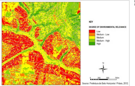
The following thematic maps were first developed and the combined to set up different levels of environmental importance.
- Erodability, areas susceptible to slides and other major geological hazards;
- Flood hazard areas;
ISSN 1828-5961 Valutare i limiti dello sviluppo e la capacità di carico in ambito urbano
- Environmental protected areas; - Groundwater recharge areas; - Green and permeable areas.
There were different levels of environmental relevance resulting from the combination of the criteria that has been used. The higher the degree of environmental relevance, the more indicated the areas for protection, conservation and preservation purposes. (Figure 1).
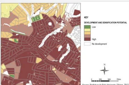
Following the same methodology, the analysis of development and densification opportunities was first built up from the following thematic maps covering a series of legal, zoning and land use constraints such as:
- Areas classified as Environmental Protection Zones (parks, recreation sites and conservation units) and Special Social Interest Zones (slums and informal settlements to be upgraded) according to current local zoning ordinances; - Areas which are currently occupied by major
public and intuitional facilities such as airports, cemeteries, university campi, stadiums, sanitary landfill, water and sewage treatment plants, etc.
- Areas located on very steep slopes (over 47%); -Streams, ponds, wetlands and water spring
protection areas according to specific legislation;
- Roads, railways, water supply and electricity transmission lines (rights of ways), also according to specific legislation;
Other thematic maps were developed to come up with constraints for development or densification due to social economic, cultural and functional reasons such as:
- Areas with a high concentration of low income dwellings (over 40%);
- Consolidated areas where the potential for urban renewal is low: high concentration of high rise buildings, social housing, listed buildings and public institutions;
- Areas where population density is already considered high (above 150 inhabitants/ hectare);
- Areas with high mobility restraints. In this case an specific GIS methodology was adopted7
according to which the accessibility level was assessed by sector considering two different
aspects: the internal accessibility within the district being studied with regards to regional or local central places, and the accessibility with regards to the Metropolitan Central Business District considering the relative independence of each region according to origin-destination data available.
There were built different degrees for development and densification possibilities. The higher the degree, the more suitable the area for development strategies, according to the combined criteria used. (Figure 2).
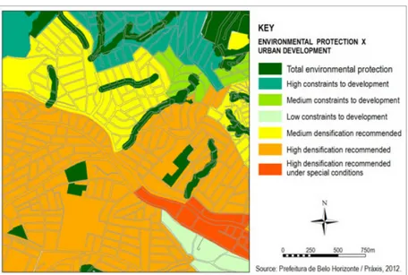
To achieve the final synthesis according to which development restraints and potentials are confronted, these two resulting maps were taken as the axis of a matrix also set up as a multicriteria analytical tool represented by Figure 3. The resulting development and protection categories were then mapped to indicate the following zoning possibilities. (Figure 3)
These final results were then analyzed from the perspective of other planning restrictions such as the existence of Special Design Criteria Zoning Districts or Urban Renewal Project Areas. The resulting color shades indicate different restraints or permission for development, densification or protection with regards to the corresponding planning criteria related to zoning categories shown in Figure 4 and described as the following. (Figure 4).
- Total Environmental Protection including areas of permanent preservation along water bodies and springs, parks, Environmental Protection Zones, Private Natural Reserves and new proposed preservation areas.
- High Constraint to Development: including geologic hazard zones, conservation areas, areas with critical infrastructure and accessibility problems where development densification should be constrained and where irregular or inappropriate informal settlements are to be regularized, removed or upgraded. - Medium Constraint to Development: areas
where development and densification levels should be kept at low levels due to environmental and landscape features that
Figure 1: Degree of Environmental Relevance
ISSN 1828-5961 Valutare i limiti dello sviluppo e la capacità di carico in ambito urbano
should be protected through special planning regulation and design criteria.
- Low Constraints to Development: areas with good topographic conditions, access and infrastructure, where development and densification may reach moderate levels in face of environmental, landscape and cultural attributes to be protected under special regulation.
- Medium Densification: areas with good topographic conditions, accessibility and infrastructure levels where development and medium densification may take place with no significant change in neighborhood characteristics and building patters currently practiced.
- High Densification: areas with very good topography, accessibility and infrastructure, where densification and diversity are to be encouraged without significant impacts to urban structure.
- High Densification under Special Conditions: areas with very good topographic conditions, good accessibility and infrastructure, and high renovation potential, indicated for public private partnerships for urban renewal projects that include high density and vertical structures by the adoption of specific building types that also provide public spaces, low cost housing, community facilities and infrastructure improvement.
3. DENSIFICATION AND PROTECTION STRATEGIES FOR A SUSTAINABLE URBAN STRUCTURE
The notion of structure, according to Bastide (1983), is related to a whole that is composed of parts that are related to each other in a way that any change limited to one element affects all others. As far as land use planning is concerned, Deak (2001) recognizes that all activities require a specific location in space and the degree of interconnection established among these locations are defined according to the existing interaction among these activities. From this author´s perspective, those interactions define how space is or will be structured. He identifies
Figure 2: Development and Densifi-cation Potential
Figure 3: Development and Densi-fication Potential X Environmental Constraints
ISSN 1828-5961 Valutare i limiti dello sviluppo e la capacità di carico in ambito urbano
as fundamental elements of urban special structure the metropolitan central business district, the other lower level trade and service sub-centers, the residential neighborhoods which tend to be segregated by social classes, the industrial zone, and so on. He also states that this spatial structure is imbricated to other territorial ones such as roads and utility networks. In this present case study, it is important to mention that the city districts that have been studied are subjected to a metropolitan dynamic according to which the location of those activities and their interconnections should be understood.
Villaça (2001, p 18) points out specific aspects of urban inner space structure that, according to him, follow a different rational compared to regional ones. That’s is why he refers to inner urban space structure as a territorial network that is also linked to nonspacial ones that belong to economic, political, social, cultural and ideological dimensions, resulting a spatial structure that is socially produced and that, at the same time, reacts over how society is organized. This way, he insists on the importance
of the identification and understanding of the many different elements that form the urban territorial structures: the various neighborhoods, the central business district, the transportation system, etc. along with the other structures that are linked to them.
Thus, the concept of urban structure adopted is this paper first considered the natural (topography, water bodies, landscape elements) and man-made (expressways, railways, large nonresidential structures) barriers, attraction poles and central places that, together with demographic, land use, social and cultural characteristics of population settlements result different degrees of dependence among regions, districts and neighborhoods, also providing identity to each of them. These spatial structure units were called subareas, articulated among themselves around a central place or by very strong common characteristics, forming macro-areas that very frequently overpass municipal boundaries.
The limits of those urban structure units were then matched with census districts and public
service jurisdiction areas, as an attempt to include the population attraction logic that is under the spatial organization of the neighborhoods that integrate each of those macro-areas. The final adopted sub division also resulted from discussions with local planning officials and neighborhood representatives that participated in technical and community workshops and public hearings that took place during the development of the master plans.
The plan´s proposal for urban restructuring and renewal aimed at the improvement of the existing connections among the macro-areas and subareas that have been identified, as well as at the reinforcement of existing central places and the proposition of new ones through infrastructure investments, densification and land use strategies, the implementation of urban equipments and amenities such as schools, health centers, digital inclusion centers, parks and public spaces.
Given this broad structure design, detailed strategies for the so called sustainable urban structure were then developed, including areas to be developed and densified, areas to be protected for both environmental and cultural heritage motivations, areas to for the development or creation of central business districts and areas to be reserved for the implementation of social housing projects. According to these same objectives, priority infrastructure projects have been selected for being considered relevant for the consolidation of the proposed urban structure.
For that purpose, the studies concerning urban space carrying capacity assessment that resulted in the indication of areas to be preserved and areas to be developed and submitted to densification processes were fundamental for the new spatial structure proposed for the municipal territory. This proposal aims at sustainability goals as well as at the increasing functional independence of regions and districts within the city with the creation of new central places that will offer new business, shopping, work and recreation opportunities and reduce population commuting to the traditionally dense
Figure 4: From Environmental Pro-tection to Urban Development
ISSN 1828-5961 Valutare i limiti dello sviluppo e la capacità di carico in ambito urbano
areas of the city.
Both with regards to already occupied areas and those still to be developed for future uses, many conflicts have been made explicit by the mapping approach since many public policies frequently compete for the same areas for incompatible or sometimes complementary strategies such as environmental preservation and social housing, flood control infrastructure and social community and public service facilities, slum upgrading and geologic hazard prevention projects.
Still with regards to the new structure proposed for the municipality from a decentralization perspective, the implementation of planning tools that are present in the City Statute and in Belo Horizonte´s Master Plan has also been considered a very important strategy. Among them, the costly grant of additional development rights stands out as an important instrument to control density as well as to promote a fairer distribution of development costs and gains for both private and public sectors, since all financial resources collected should be invested in social housing and related utilities and amenities. Also based on the urban structure proposal, the estimation of the current available building potential storage has been calculated according to the carrying capacity studies that defined the areas where additional building and development rights could be granted. The methodology that has been applied resulted in different scenarios according to different zoning possibilities and the alternative use of urban renewal projects affecting specific areas along main transportation corridors and surrounding metro stations.
4. FINAL REMARKS
The use of GIS and multicriteria analytical methods as a basis for all studies that supported the development of Belo Horizonte’s nine districts’ Regional Master Plans demonstrated the possibilities for improving planning strategies through more reliable and systematic technical information to make more rational decisions about areas to be persevered, developed or densified according to a combination of environmental, infrastructure and socio economic features in a
leveraged way.
Besides applying the carrying capacity principle to come up with a new urban structure proposal to the municipal territory that is aimed to be socially fairer and environmentally more sustainable, the use of digital cartography as a resource for building alternative scenarios has proved to be a very powerful instrument to make social spatial conflicts explicit, faced and discussed in a very clear cut and illustrated way. The final analytical maps that have been prepared were a very useful tool for the participatory planning events as well as they continue to be for the permanent decision making processes involving integrated public policies and compatible urban environmental development strategies.
Far beyond the simple use of thematic maps, that are usually very reductive of the complex and contentious urban relations and disputes in which planning actions are supposed to interfere and control, the multicriteria analytical methods allow complementary or opposing categories to be combined, integrating information of distinct natures and helping the decision making processes to become more systematic and objective.
However, for similar improvements in conflict resolution it is also essential to improve the social and political bases of participatory planning processes towards a less segregated urban structure and a more equitable distribution of environmental impacts, development costs and benefits among all different social groups in our cities.
ISSN 1828-5961 Valutare i limiti dello sviluppo e la capacità di carico in ambito urbano
NOTE
1 The list and the content of all research papers presented at the Seminar on Support Capacity held by the Brazilian Ministry of the Environment in August 2012 are available at http://www.mma.gov. br/port/conama/reunalt.cfm?cod_ reuniao=1575 (Accessed on October 22nd.2012).
2 Costa (2000) shows how the apparent consensus that is present in the mainstream discourse that is associated with the principle of environmental sustainable development shadows instead of highlights the real social environmental conflicts and contradictions which are inherent to the production of urban space within a capitalist society.
3 The approach to environmental issues within the local Master Plans of Brazilian Municipalities which were developed after the enactment of The City Statute has been organized and analyzed by COSTA et al. (2011) as a research project that is part of the National Network for Technical Training, Implementation and Evaluation of Local Master Plans under an agreement between the Federal University of Rio de Janeiro (IPPUR) and the Brazilian Ministry of Cities.
4 Belo Horizonte, located in Southeastern Brazil, is the capital of the State of Minas Gerais and has a population of 2,375,151
inhabitants according to 2010 IBGE Brazilian Census Data. It is the major city of its metropolitan area that is composed of 34 municipalities with a population of over 5,4 million people.
5 The City Statute is a 2001 Federal Act that established a series of planning tools and strategies that local governments are entitled to implement in order to balance urban development costs and benefits among public and private interest groups. (BRASIL, 2001).
6 Belo Horizonte´s nine Regional District Master Plans were commissioned in 2011 and had their basic surveys and studies developed between January and July, 2012 by two consulting firms: Práxis Projetos e Consultoria Ltda. based in Belo Horizonte, MG and Tese Tecnologia em Sistemas Espaciais from Curitiba, PR. All Project activities were developed with the participation of the municipal planning authority technical team based at the Secretaria Municipal Adjunta de Planejamento Urbano – SMAPU, that coordinated and supervised the whole planning process. (PBH, 2011).
7 The methodology used to analyze degrees of accessibility was adapted by the consulting firm TECTRAN, that used a model originally developed by Rodrigues da Silva (2008) for the evaluation of accessibility levels in university campi.
BIBLIOGRAFIA
Acselrad, Henri (2009), Os Sentidos da sustentabilidade urbana, in A duração das cidades: sustentabilidade e risco nas políticas urbanas, Lamparina Editora, Rio de Janeiro, pp. 43-70.
Bastide, Roger (1983), Sociologia, in Maria I. P. Queiroz, Ática, São Paulo. Belo Horizonte (2011), Termo de Referência para Elaboração dos Planos Diretores das Regiões Administrativas do Município de Belo Horizonte, Secretaria Municipal de Política Urbana.
Brasil, (2001), Lei Federal nº 10.257 de 10 de julho de 2001: Regulamenta os Arts. 182 e 183 da Constituição Federal, estabelece diretrizes gerais da política urbana e dá outras providências, Governo Federal, Brasil.
Brasil, Ministério do Meio Ambiente (2012), Seminário de Capacidade de Suporte. Brasília, DF. Available at: < http://www.mma.gov.br>. Access: 22/10/2012.
Campos Filho, Candido Malta (2003), Reinvente seu Bairro: caminhos para você participar do planejamento de sua cidade, Editora 34, São Paulo. Costa, Heloísa Soares de Moura (2000), Desenvolvimento Urbano Sustentável: uma contradição de termos?, in Revista Brasileira de Estudos Regionais, 2(1),pp. 55 -71. Costa, Heloisa Soares de Moura,
Araujo, Rogério Palhares, Campante, Ana Lúcia Goyatá (2011), A Dimensão Ambiental nos Planos Diretores de Municípios Brasileiros: um olhar panorâmico sobre a experiência recente, in Santos Jr., Orlando Alves, Montandon, Daniel Todtmann, Os Planos Diretores Municipais Pós Estatuto da Cidade: balanço crítico e perspectivas. Letra Capital, Rio de Janeiro, Observatório das Cidades: IPPUR/UFRJ. Deák, Csaba (2001), À busca das categorias da produção do espaço, Tese de livre docência, FAU USP, São Paulo. http://www.usp.br/ fau/docentes/depprojeto/c_deak/ CD/3publ/01LD-categ/MC-categ-esp.pdf. Access: 05/10/2012. Moura, Ana Clara Mourão (2005), Geoprocessamento na Gestão e no Planejamento Urbano, Ed. da autora, Belo Horizonte, 2nd. ed. Rodrigues da Silva, Antônio Nelson et. al. (2008), SIG: Uma Plataforma para Introdução de Técnicas Emergentes no Planejamento Urbano Regional e de Transportes. EdUFSCar,São Carlos.
Villaça, Flávio (2001), Espaço intra-urbano no Brasil. Studio Nobel – FAPESP -Lincoln Institute, São Paulo.