ALMA MATER STUDIORUM
UNIVERSITA' DI BOLOGNA
SCUOLA DI SCIENZE
Corso di Laurea Magistrale in
BIOLOGIA MARINA
A first survey on the status of the Posidonia oceanica meadow
in Calpe Bay (Alicante, Spain)
Tesi di laurea in
Alterazione e conservazione degli habitat marini
Relatore: Presentata da:
Prof. MARCO ABBIATI MARTINA SCANU
Correlatore
Dott. JOSE RAFAEL GARCIA-MARCH
1
SUMMARY
1. Introduction………...…...3
1.1 Evolutionary history………..…3 1.2 Habitat distribution………...….4 1.3 The plant………..…..……5 1.4 Ecology………..8 1.5 Structure of meadows………91.6 The role of Posidonia oceanica meadows in coastal systems………9
1.6.1 Ecological role………9
1.6.2 Physical role………..…12
1.6.3 Economical role………12
1.6.4 Bioindicator role………...13
1.7 The causes of regression………..…16
1.8 Policies apllying to Posidonia oceanica meadows………..18
2. Work prupose………..………...…21
3. Materials and methods……….……….22
3.1 Study area………22 3.1.2 Geological context………....23 3.1.3 Marine context……….….24 3.2 Physical descriptors……….25 3.2.1 Water conditions………...25 3.2.2 Sediment analysis……….………26
3.3 Monitoring Posidonia oceanica………..29
2
4. Results………...…..34
4.1 Physical descriptors………...……….….34
4.1.1 Water conditions………...34
4.1.2 Sediment analysis……….……….38
4.2 P. oceanica monitoring results……….44
5. Discussion………...………53
6. Conclusion………..………60
3
1. Introduction
Posidonia oceanica (Linnaeus) Delile, (1813) is a marine plant,
with roots, vascular trunks, leaves and flowers. The name “Posidonia” was put in honor of Poseidon, god of the sea, while the Latin name “oceanica” was given by Linnaeus, however is misleading since this species is not found in the Atlantic ocean (Cabioch et al., 1995).
1.1 Evolutionary history
About 120-110 million years (Ma) ago, in the Cretaceous period, some continental angiosperms, the Phanerogams, returned to the marine environment. Further back in time, about 475 Ma ago, in the Ordovician (Primary era), their distant ancestors had left the marine environment to colonize the continents (Wellman et al., 2003).
By the number of their species in today’s natural environment, marine angiosperms represent rather a small group: 13 genera and 60 species (Kuo et al., 2011). For purposes of comparison, there are 234 000 angiosperms species (almost all continental) and about ⁓2.2 million (60.18 million SE) marine species of fauna and flora together (Fredj et al., 1992, Heip et al., 1998, Mora et al., 2011). There are three hypothesis that could explain this big difference in the marine and terrestrial number: (1) the predominance of vegetative reproduction compared to the sexual one for marine angiosperms, excludes genetic recombination and turn off the evolutionary motor (Romero 2004). (2) The absence of mutualistic symbiosis with insects for pollination reduces the speciation events (Romero 2004). (3) Lastly, the competitive advantage the marine angiosperms have over other marine primary producers is so great that competition has not driven evolution (Boudouresque 2012).
However, although the marine angiosperms are not numerous, their ecological role is considerable in coastal environments: many of them are ecosystem engineers or at least key species. The ecosystems they build up or in which they are the major actors, play an essential role in many parts of the world. This is true for the Mediterranean sea (Boudouresque 2012), where in addition to P. oceanica there are other species of seagrasses whose (Table 1.2).
Taxonomic classification Empire Kingdom Phylum Subphylum Infraphylum Superclass Class Order Family Genus Species Eukaryota Plantae Tracheophyta Euphyllophytina Spermatophytae Angiospermae Monocots Alismatales Posidoniaceae Posidonia oceanica Table 1.1 Taxonomic classification of P. oceanica (AlgaeBase).
4
Species Distribution Habitat Maximum depth (m) Rhizome diameter (mm) Leaf length (cm) Leaf width (cm) Hypogea biomass (gdw m-2) Posidonia oceanica Mediterranean Sea, stops at the border line where
Mediterranean and Atlantic waters mix Common on sandy bottoms, is often found on rock and coralline 50 10 115 1.2 6526 Cymodocea nodosa Widely distributed throughout the Mediterranean, around the Canary Islands
and down the North African coast Common on sandy bottoms, it prefers calm hydrodynamic environments 40 2 40 0.36 324 Zostera marina Limited and pointform; reported in Italy Common on sandy and muddy bottoms, it suits low-salt waters, low tolerance to desiccation 7 3.5 60 0.6 Min 21 Max 161 Zostera noltii Widely distributed throughout the Mediterranean Common on sandy and muddy bottoms, it suits low-salt waters 6 1.3 40 0.10 Min 31 Max 62 Halophila stipulacea Present in the eastern Mediterranean, reported in Italy Common on sandy bottoms 30 1.3 7 0.7 -
Table 1.2 Summary of the main characteristics of the Mediterranean seagrasses (modified from Buia et al., 2003)
1.2 Habitat distribution
Currently, the genus Posidonia presents a bipolar distribution: of the 9 known species, P. oceanica is endemic to the Mediterranean Sea, while the other 8 species are widespread in the seas of Australia. P. oceanica is present almost throughout the Mediterranean sea. Its range of distribution finishes just before the Strait of Gibraltar on the west side (Conde Poyales 1989), and it is absent from the Egyptian coast to Lebanon (Por
1978) on the east side (Fig. 1.1). Figure 1.1. Geographical distribution of P. oceanica in European coastal waters. (Borum et al., 2004).
5
It is known that most of the Mediterranean sea dried up in the Messinian period, 5.6 to 5.3 million years ago, because of the closing of the Strait of Gibraltar, but is unknown how P.
oceanica survived this crisis. Maybe refuge areas existed, from which it could recolonize the
Mediterranean after the Gibraltar Strait reopened (Boudouresque et al., 2012).
P. oceanica is the only seagrass colonizing in a continuous way the coastal zone between the
surface and the 40 m depth (Buia et al., 2003), is unique among seagrasses in that it can thrive on either rock or sand (Giovannetti et al., 2008).
1.3 The plant
P. oceanica is made of horizontal and vertical
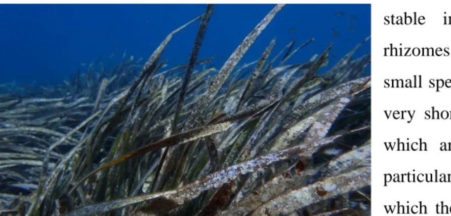
stems, more or less woody, usually buried in the sediment, called rhizomes. They can be of two types: the horizontal called plagiotropic, and the erect orthotropic (Fig. 1.2); there is not a functional differentiation between these rhizomes, and the environmental conditions can determine the growth pattern. The vertical growth is favored in areas were sediment deposition is very intense, whereas the horizontal one promote the extension of the seagrass beds and plant tends to colonize or re-colonize the substratum.
Regardless of the type, the rhizomes support shoots (Fig 1.3) made by a little group of leaves, generally 4-8. Leaves are 8-11 mm wide and may reach 150 cm in length. In the shoot, they present an alternate disposition, being the central leaves the youngest and the external the oldest. Leaf growth zone (meristem) lies at its base. Every leaf consists of a base (petiole) and of the limbo. The limbo is the visible part of the leaf, is from green
color to dun, according to the leaf age, and it can be densely covered by organisms that are
Figure 1.2. Anatomical details.
6
fixed on, the epiphytes. The petiole is almost not pigmented, it is fibrous and the real leaf appears after it. It can measure up to 5 cm and is separated from the limbo by a semicircular mark (lanula), which is where the split takes place in the fall of the leaf. The morphological features allow to classify leaves in: juveniles less than 5 cm long, intermediate longer than 5 cm and adult when a petiole is formed (Giraud et al., 1979, Boudouresque et al 1983).
When they die, the leaves do not fall off at all, the basal leaf (petiole), remains attached to the rhizome (Fig. 1.4). The vegetative season is all year, leaves are formed and drop all year round (Pergent et al., 1991). Detached leaves are not very putrescible, and they can last for several centuries, creating a peculiar habitat for detritivorous invertebrates. The analysis of the age and growth of the plant based on leaf structure is known as lepidochronology (Crouzet
et al., 1983). This is a powerful tool for measuring the speed of growth, past primary production, old pollutant levels, etc. (Pergent et al., 1990).
Generally leaves live between 5 and 8 months and more rarely up to 13 months. This species presents a peculiar life cycle, with a few marked seasonal
variations, being in the leaves better where it is estimated. It is possible to speak about several phases. The juvenile phase, or of hard latency, from October to February. During this period new, short leaves are formed with few epiphytes. The phase of maturity or activity is from March to June, and though new leaves are not generated, the existing ones present a very rapid growth. The phase of old age or of sluggish growth lasts from June to September, and during this period the growth is diminishing to the minimum; in the center of the bundle, a great number of leaves appear. At the same time, the existing leaves are aging and reach their maximum heights, and are loaded with epiphytes, reducing its photosynthetic efficiency. Though the loss of the leaves
Figure 1.4. Characteristic rhizomes, consisting largely of petiole, basal part of the leaves.
Figure 1.5. Large amount of dead leaves dropped at the end of summer.
7 is continued all the year round, it is more intense from August, when it is possible to say that the fall begins (Fig. 1.5), being with the big autumns storms with the maximum loss of leaves will take place. The same storms drag up to the coast the fallen leaves, forming they typical accumulations on the beaches, called “banquettes” (Calvo 1995) (Fig. 1.6).
Being a real plant, P. oceanica produces flowers, but does it rarely. Usually, less than 1 flower is produced per 10 square meters per year, but flowering may be more frequent during warm years (Borum 2004). The flowers are hermaphrodites and are grouped in inflorescences that arise in the center of the bundle, which impedes its observation (Fig. 1.7). The pollen forms viscous filaments that drift. The fruits of P. oceanica have the shape and the size of an olive; they are generally dark green and have just one seed (Hartog 1970). They require 6-9 months to ripen. Between May and July, they drop off and float for a certain time. According to the direction of the currents, they may be washed up on beaches in great quantities. However, P. oceanica reproduces mainly in a vegetative way; this reproduction strategy is called “stolonization”, and occurs by dispersion of rhizome fragments and its horizontally increasing by producing lateral ramifications.
P. oceanica’s low genetic variability could be a weakening factor for this species (Raniello et
al., 2002). The rarity of the flowering and, especially, seed production, as well as self-pollination, and inversely the frequency of vegetative reproduction could explain this feature of low variability. The little investment and low success of sexual reproduction, combined with the extremely slow clonal spread of P. oceanica explains the extremely slow colonization rate of this species. Numerical models simulating the occupation of space by P. oceanica meadow suggest that it would need 600 years to cover 66 % of the space available. Similar colonization timescales have been calculated based on patch size and patch growth rate in patchy P. oceanica
Figure 1.6. "Banquettes" formations along La Fossa beach, Calpe.
Figure 1.7. P. oceanica flower phases: (1) apariencia, (2) ovule formation and several dehiscent anthers, (3) fertilized ovule, (4) seed, germinating producing first leaves, small rhizome and a root to be fixed to the sediment.
8
meadows. The very long time scales for colonization of this species indicate that recovery of disturbed P. oceanica meadows, where important plant losses have occurred, would involve several centuries (Borum 2004). P oceanica is a long-living seagrass, with shoots able to live for at least 30 yr P. oceanica recruited shoots at low rates (0.02 to 0.5 In units yr-1) which did not balance the mortality rates (0.06 to 0.5 In units yr-1) found in most (57 %) of the Spanish meadows. If the present disturbance and decline rates are maintained, shoot density is predicted to decline by 50% over the coming 2 to 24 yr. Because P. oceanica rhizomes grow very slowly (1 to 6 cm yr-1), maintenance of existing meadows is essential, and our results suggest bad future prospects for P. oceanica in the Spanish Mediterranean Sea like most other seagrass species in the world oceans (Marbà et al., 1996).
1.4 Ecology
In calm conditions, P. oceanica can develop very near average sea level: its leaves then spread out on the surface, while the maximum depth depends on water transparency. In fact, light is one of the most important factors for the distribution and density of P. oceanica regulating the lower depth distribution (Elkalay et al., 2003).
P. oceanica dislikes low salinity. It dies off immediately below 33 ‰. The species appears to
resist high salinity levels more successfully, although Ben Alaya (1972) has shown that 41 ‰ constitutes its upper tolerance limit. In fact, for example, it is present in the hypersaline lagoons of Tunisia (Bahiret el Biban, 46‰ in August) and Libya (Farwa: 39-44‰ according to the season); in these lagoons its vitality, as number of leaves produced per year, seems identical to or above what is observed out at sea (Romero et al., 1992, Pergent et al., 2000).
The extremes of temperature measured in a P. oceanica meadow are 9.0 and 29.2°C (Augier et al., 1980). It is, however, possible that low and high temperatures are only exceptionally borne.
P. oceanica’s absence from the Levantine coast and its scarcity in the northern Adriatic could
be due respectively to the summer and winter temperatures. Also, in deep meadow, Mayot et al., (2005) suggest that the increase in seawater temperature that is currently observed, could have a harmful effect on this seagrass. The temperature is therefore considered the overall parameter controlling the geographical distribution of the species in Europe.
Moreover, P. oceanica dislikes too intense hydrodinamism, and exposure is the most important factor regulating the upper depth distribution of a meadow. In general, it is estimated that
9
seagrasses do not exist at flow velocities above 1.5 m per second or at very exposed shores. Currents and wave action prevent seagrass growth and distribution by causing resuspension and transport of the sediment. Besides affecting the general light climate of the water column, erosion can expose roots and rhizomes causing the seagrasses to detach from the sediment. Additionally, very strong currents or wave action may tear up entire plants or prevent new shoots from being established (Borum 2004). Storms tear off shoots and can also erode the “matte”, either directly, or by leaching the sediment, which weakens the meadows. That is why in rough sea conditions the meadow grows no nearer the surface than 1 or 2 meters.
1.5 Structure of meadows
Seagrasses deeply alter the environments they colonize, giving rise to specific systems, known as the most diverse, complex and productive meadows present along the coastal zone of almost all the oceans and seas (Short and Coles 2001). The leaves and rhizomes of P. oceanica support many flora and fauna, some of which are calcified. When they die, their remains fall off and form an autochtonous sediment. Moreover, because of their density and distribution, the leaves of P. oceanica reduce the speed of the current; this reduces the kinetic energy of the sedimentary particles carried by the water, which then deposits on the seabed, constituting the allochthonous sediment (Boudouresque 2012).
P. oceanica rhizomes grow in height, even in the absence of sedimentation. To resist being
buried, they are capable of speeding up their growth (Boudouresque et al., 1994).
The “matte” is the whole mass composed of rhizomes, leaves, roots and the sediment that fills the interstices. All complex is not very putrescible and is conserved for several centuries or even thousands of years (Boudouresque et al., 1983). Over the course of time, the “matte” rises to the surface, Moliner and Picard (1952) measured a seabed elevation of 1 meter per century. The “matte”’s elevation, in some conditions, can reach the surface, forming a barrier reef.
1.6 The role of Posidonia oceanica meadows in coastal systems
1.6.1 Ecological role
Darwin (1859) was the first to say that marine seagrasses can constitute a food base for many species of macro-herbivores.
10
As with forests in the terrestrial environment, P. oceanica meadows are the climax community and their presence attests to a relatively stable environment. In numerous Mediterranean coastal water ecosystems, P. oceanica plays an important role in a number of key geomorphological and ecological processes such as nutrient recycling (reducing the degree of water movement, thus improving sediment stability), provision of food for herbivorous fauna, shelter and nursery areas for many organisms (e.g. fishes, crustaceans) (Francour et al., 1999). These meadows are also a unique biodiversity hotspot (Boudouresque 2004).
Just inside the meadow it is possible to distinguish two populations: one photophilous and adapted to the expiration of the leaves on which it is installed, and another sciophilous and more stable installed in the stems and rhizomes. The leaves are occupied by small species of epiphytes (Fig. 1.8), of very short life and very fast crescent, which are adapted to the rapid and particular growth of the substrate in which they are fixed. In the rhizomes, propriate species of the rocky bottoms are installed. Thus, if the density of the meadow is high, the light that reaches the rhizomes is scarce and the species that appear belong to the precoraligenous community or the sciaphilic algae of calm regime, whereas if the density is low, the light that arrives at the rhizomes is enough so that the species of the infralittoral photophilic algae community can calmly settle down. In the buried part of the rhizomes, a typical fauna of soft bottoms is installed, rich in bivalves, polychaetes and small crustaceans.
A basic feature of the P. oceanica ecosystem is the combination of two kinds of primary production; at global level, only marine seagrasses ecosystems present this special feature (Boudouresque et al., 1996). (1) The primary production from P. oceanica is rich in cellulose and lignin, compounds that are not used much by herbivores, and in phenolic compounds, one of whose roles is to dissuade potential consumers. The net primary production of P.
oceanica is on average between 420-13000 g DM/m2/year (DM = dry mass); it drops in relation to depth (Pergent et al.,
Figure 1.9. Production processes (Boudouresque et al. 2012). Figure 1.8. Dense epiphytic community on P. oceanica leaves.
11
1997). (2) The primary production from the Multicellular Photosynthetic Organisms (MPOs) leaf epibiota is composed of very palatable Rhodobionta and Chromobionta, thus easily usable by herbivores; it is between 100 and 500 g DM/m2/year (Giorgi and Thelin 1983). All in all, the P. oceanica ecosystem is one of the planet’s most productive ecosystems (Boudouresque 2012). Vegetal biomass is also very high and decreases with depth (Mazzella et al., 1992). No other marine ecosystem, except mangroves, presents such high vegetal biomass. This is due to the storage of the biomass over a long period of time in the “matte”. Little (less than 10%) of the primary production is used by herbivores. These are mainly the fish Sarpa salpa (Fig. 1.10), the sea urchin Paracentrotus lividus, isopod crustaceans Idotea hectica, spider crabs Pisa
mucosa and P. nodipes (Boudouresque and Verlaque 2001). The modest grazing role of S. salpa
could constitute an artifact linked to human action; indeed, in a certain number of Marine Protected Areas (Tabarca and Medes Islands in Spain, Port-Cros in France, El Kala in Algeria) overgrazing by S. salpa was observed (Boudouresque et al., 2012). On the other hand, the leaf epibiota is widely used, in particular by gastropods. Much of the primary production (24 to 85 %) is exported in the form of dead leaves; they may constitute up to 40% of the digestive contents of sea urchin P. lividus in a hard substratum community some hundreds of meters away from the nearest meadow (Cebrian and Duarte 2001).
Figure 1.11. Meadow patch with clear signs of herbivorous S. salpa. Figure 1.10. Individuals of S. salpa grazing on P.
12 1.6.2 Physical role
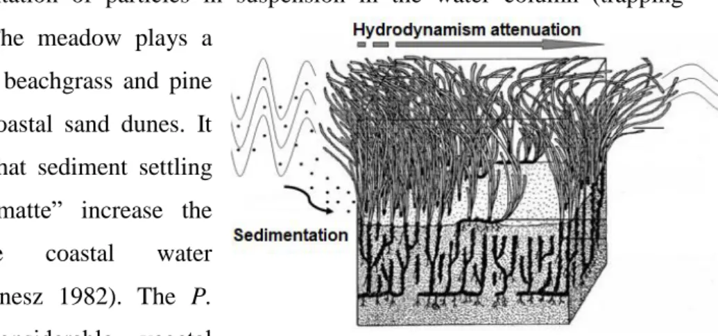
On the coastal seabed, P. oceanica meadows are real plant barriers that encourage the decantation and sedimentation of particles in suspension in the water column (trapping sediment) (Fig. 1.12). The meadow plays a
similar role to European beachgrass and pine trees that stabilize the coastal sand dunes. It should also be noticed that sediment settling and trapping in the “matte” increase the transparency of the coastal water (Boudouresque and Meinesz 1982). The P.
oceanica meadow’s considerable vegetal
biomass also acts as a kind of barrier which
slows and effectively absorbs hydrodynamism at the seabed. Some experiments in laboratory and in situ showed that a meadow can reduce hydrodynamism from 10 to 75% the under the cover of leaves and 20% above the canopy (Gacia and Duarte 2001). This hydrodynamism reduction is particularly visible behind the P. oceanica barrier reefs, where the presence of these plant barriers enables sheltered lagoons to be established (Boudouresque et al 1994) and more generally the reduction in waves and currents is likely to protect from coastal erosion and helps stabilize the shoreline.
1.6.3 Economical role
It is the result of the ecological and physical importance in the coastal system. It obviously affects the management of living resources via its high biological production, the protection from predators it offers to young fish and young organisms, and it also continues a much sought- after spawning ground for many species of commercial interest (Connelly et al., 2005). It also affects the development of tourism and seaside activities, by helping maintain water quality, and especially by stabilizing the shoreline that it defends by protecting it from erosion. Furthermore, even if the meadows are not always the “spots” sought by divers, they are at the origin of significant exported biological richness (in terms of species and food) to other more sought-after habitats (Boudouresque 2012). Moreover, P. oceanica leaves dead can be very useful. Use of the leaves inside mattresses, or as bedding for animals, went on for a long time; indeed, “vermin” never entered the mass, certainly because of the phenolic acid contained in
Figure 1.12. Physical role of P. oceanica meadow, modified from Bourdouresque and Mainesz. (1982).
13
the leaves (Bourdouresque et al., 2012). For centuries, when there was not yet any bubble wrap or expanded polystyrene, P. oceanica leaves were used by the Venetians to wrap up and transport their famous, delicate glasswork, to the extent that these leaves were known as “Venetian straw”. In North Africa, in the early 20th century the coastal populations were still using dried P. oceanica leaves to build roofs, while in Corsica, Sicily and Greece these were used for thermic and sound insulation. Dead P. oceanica leaves were also used for a long time as compost by farmers on the Mediterranean coast.
1.6.4 Bioindicator role
For several years now, the use of seagrasses for environmental monitoring, to assess the evolution of impact, or more generally to manage coastal ecosystems has been envisaged. The use of these species, known as “bioindicators”, seems to be a quick and effective way of assessing the quality of the environment (Bellan 1993).
Seagrasses in general, and P. oceanica meadows in particular, are considered to be appropriate for biomonitoring because of their wide geographical distribution, reasonable size, sedentary habit, longevity, permanence over the seasons, easy collection and abundance and sensitivity to modifications of the littoral zone. Reasoned management, on the scale of the whole Mediterranean basin, requires standardized methods of study, to be applied by both researchers and administrators, enabling comparable results to be obtained (Pergent-Martini et al., 2005). In particular, P. oceanica meadow constitutes a powerful integration of overall marine water quality, it demonstrates by its presence and its vitality the quality of the water above it. Moreover, their rhizomes concentrate radioactive, synthetic chemicals and heavy metals, recording the environmental levels of such persistent contaminants.
In summary P. oceanica seems to be a reliable bioindicator according to: (1) their sensitivity to disturbances, as demonstrated by a number of reports of meadow regression due to various causes; (2) its wide distribution along the Mediterranean coast and (3) the good knowledge about specific response of the plant and of its associated ecosystem to specific impact (Tab. 1.3). Furthermore, as said, this species is able to inform about present and past level of trace metals in the environment (Pergent-Martini, 1998).
14
Moreover, P. oceanica meadows, from a political point of view, are included in a law issued at European level. In fact, the use of seagrasses as a tool for an ecological evaluation of coastal waters has recently been highlighted in European legislation by the Water Framework Directive (WFD 2000/60/EC). The Directive establishes the basis for monitoring, protection and enhancement of all aquatic ecosystems in the European Member States (MS), by setting ecological quality objectives (i.e. ‘‘good water status’’ for all European waters by 2015) which require to assess water quality status using a combination of ecological indicators in priority. To assess the good status of water bodies, the WFD requires that monitoring programmes are
Table 1.3. List of main descriptors of P.oceanica used in monitoring and their responses to different impacts, 1: community descriptors, 2: individual descriptors, 3: physiological descriptors (Pergent-Martini et al., 2005; Boudouresque et al., 2006; Romero et al., 2007).
15
implemented for the ensemble of aquatic environments concerned. This monitoring must be based on “biological quality elements” (BQE). For coastal waters Angiosperms, together with phytoplankton, macroalgae and benthic fauna (Devlin et al., 2007), are one of the four BQEs required for the evaluation of ecological status because of, as mentioned above, its specific responses to anthropogenic disturbance are acknowledged (Balestri et al., 2004; Ruiz and Romero, 2003; Leoni et al., 2006).
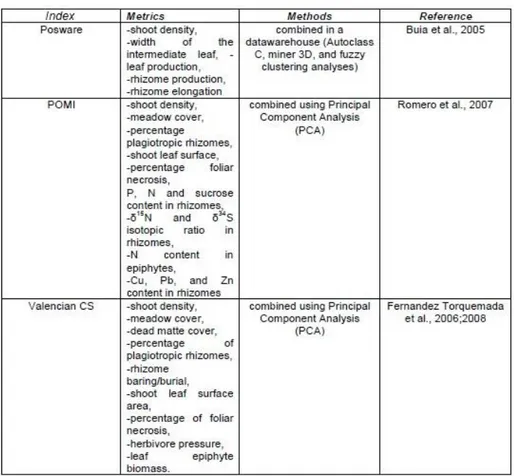
Using some descriptors, have been therefore elaborated, from the scientific community, a series of indexes (Tab. 1.4), on the P. oceanica metrics, so that the evaluation of the quality of the waters can be simple, replicable in space and time, and can have a reasonable cost.
Recently, in addition to the plant itself, the composition and abundance of the leaves epiphytic community is beginning to be used as a BQEs. In fact, the deterioration of the water quality and the increased amount of dissolved nutrients, due to the rising human pressure on coastal waters in the last century (UNEP/GPA, 2006), have been shown to affect the growth of epiphytes on seagrass leaf blades (Duarte, 2002). Increases in the epiphyte biomass, differences in their spatial heterogeneity and shifts in species composition have been observed under human disturbance regimes. Moreover, differently from the descriptors commonly adopted for
Table 1.4. Three methods based on Posidonia oceanica in the WFD to assess the ecological status of Mediterranean coastal waters (Gobert et al. 2009).
16
evaluating the health status of P. oceanica ecosystem, the epiphyte community structure was able to detect alterations in the water quality already after 4 months (Giovannetti et al., 2010).
1.7 The causes of regression
Seagrass communities, which are widely considered as key ecosystems in coastal waters (Short et al., 1996), are now challenged with hasty environmental alterations resulting from human-induced disturbance (Boudouresque et al., 2006). Worldwide seagrass loss has been reported due to a variety of both direct and indirect human impacts (Short et al., 1996; Hemminga et al., 2000). In the Mediterranean Sea, the major sources of large-scale seagrass regression include environmental pollution, eutrophication, increased water turbidity, bioinvasion, and climate changes (Montefalcone et al., 2007; Occhipinti- Ambrogi, 2007), but there are also sources of regression of little-scale.
When water transparency decreases this has a direct effect on P. oceanica meadows. Compensation depth (the depth at which the losses due to respiration balance out with photosynthesis production) becomes shallower, and with it becomes shallower the limit of the meadow. Ruiz and Romero (2001) have demonstrated experimentally, placing screens above a meadow, that a reduction in light reduces both growth rate, shoot biomass and storage of starch in the rhizomes; and after one year, when normal light intensity has been restablished there is still no sign of recuperation.
For example, a harbor construction or building coastal facilities can locally change swells and currents and alterate the normal sedimentation dynamic (erosion or accumulation). All that can, consequently, cause a clear increase in sediment organic matter and in sediment deposition rates, especially fine sand. For this reason, light availability could be reduced due to suspended sediments. Seagrass structural indicators respond unequivocally to these environmental changes, with clear reductions in shoot density (Roca et al., 2014).
Also coastal rivers can have an impact on P. oceanica meadows by: desalination to which the plant is very sensitive, nutrient and sediment inputs. The correction of watercourses can modify the granulometric features of the sediment carried down in favor of the finest particles, generating great turbidity in the water column which restricts the photosynthetic action of P.
17
Also nutrient inputs resulting from fish farming activities located in the vicinity of seagrass meadows can potentially alter the structure and affect the functioning of these ecosystems. The presence of suspended matter in the water column can cause a reduction in the amount of light reaching the seagrass, while elevated concentrations of dissolved nutrients can promote a high epiphytic cover on the leaves. The overall result is a reduction in growth rate of the seagrass and gross changes in shoot morphology (Dimech et al., 2002). In a particular way, Cabaço et al., (2013) showed that biomass and density tended to increase simultaneously under high nutrient levels in short-term experimental studies, whereas they tended to decrease simultaneously in descriptive studies where the seagrass populations were exposed to the long-term effects of nutrient increase.
Anthropogenic waste, as well ad greatly changing the sedimentary balance of the coastal water, also implies a wide range of contaminants that affect the vitality of the P. oceanica meadows. The effect of soluble substances is rapid, but insoluble substances can also have a very negative impact; being relatively stable they can accumulate to reach concentrations that are toxic to flora and fauna. The presence of a high contaminant concentration can determine the alteration of the biosynthetic pigments: along with an increasing pollution gradient, the photosynthetic pigment content in P. oceanica leaves decreases (Augier et al., 1979).
Moreover P. oceanica meadows, ranging in depth from the surface down to about 40 m, cover seabed areas that coincide with the ideal sites for pleasure- boats anchoring (Montefalcone et al., 2008). Among the various types of human activities, the mechanical damages resulting from uncontrolled pleasure boats anchoring (Fig. 1.13) in
shallow coastal waters would appear to be responsible for localized regressions of P. oceanica meadows (Montefalcone et al., 2006). The impacts of anchoring systems on P. oceanica have been shown to be recorded at two different levels: the individual level (the plant), where mechanical damage is the direct cause of pulling up leaves and rhizomes (Ceccherelli et al., 2007), and the population level (the meadow), where mechanical damage reduces shoot density and cover of the meadow (Francour et al., 1999). Experimental evaluations of the impact of anchors of small vessels have shown that each anchoring can on average damage up to 6 shoots of P. oceanica, removing
Figure 1.13. Impact of an anchor of leisure boat on P. oceanica meadow.
18
small amount of biomass and, at the same time, interrupting continuity among shoot, and the disturbance is higher where the substratum is highly penetrable (Ceccherelli et al., 2007). The frequency of anchoring at some visited sites, in terms of number of boats and extension of the visitation period, could make this chronic disturbance very stressful to the growth of the seagrass over several years; compared with the slow clonal growth of P. oceanica, estimated at about 1–7 cm yr−1, recovery may take centuries. Notwithstanding the protection measures undertaken by the European Community for their conservation, P. oceanica meadows keep on being affected by this kind of local impacts, which are hardly controlled but within marine protected areas (González- Correa et al., 2007). An alternative to direct anchoring is the deployment of anchoring chain systems to which buoys – and subsequently boats – are moored (Montefalcone et al., 2008).
Another cause of regression of the P. oceanica meadows is the competition with two Chlorobionta introduced species: Caulerpa taxifolia and C. racemosa (cylindracea). C.
taxifolia and cylindracea are native to Australia and were accidentally introduced into the
north-western Mediterranean at the beginning of the 90’s, since when its geographical expansion was relatively rapid. C. taxifolia is able to colonize almost all kinds of substrate, particularly the “dead matte”, so stressed and degrades meadows are an extremely favourable environment for this species (Boudouresque et al., 2012), while C. cylindracea colonizes bottoms bordering P.
oceanica, and its growth in height is a function of the P. oceanica shoot density and the
orientation of the meadow (Ceccherelli et al., 2000).
It is not always easy to distinguish between natural and human factors, or between the different kinds of human-induced factors, which almost act simultaneously and certainly have synergic effects, should not hide a robust scientific certainty: man really has been responsible for most of the regressions observed in the second half of the 20th century.
1.8 Policies applying to Posidonia oceanica meadows
For all the reasons mentioned above and due to the fact that P. oceanica meadows have great short-term recovery difficulties, this led to enhanced efforts in protecting legally the species in many Mediterranean countries (Platini 2000).
19
It is useful differentiate between direct legal protection measures either concerning the species
P. oceanica or the habitats it constitutes, and regulatory measures which, without directly
aiming to protect the meadows, can indirectly encourage their conservation.
In policy terms, the ecosystem approach is a relatively recent one and only international conventions signed after 1990, or those were produced before this date but were updated, possibly take P. oceanica meadows into account. This is the case of the Bern Convention (Convention on the conservation of European wildlife and natural habitats), signed in 1979 under the auspices of the Europea Council by several Mediterranean countries. Indeed, while it did not initially mention any marine plant species, its Annexes were modified to add three of the seagrasses species of the Mediterranean Sea (Cymodocea nodosa, Posidonia oceanica and
Zostera marina). The same holds good for the Barcelona Convention, adopted in 1976, which
was the key convention for the protection of the areas and species in the Mediterranean. A legal tool of the Mediterranean Action Plan (MAP), launched by the UNEP (United Nations Environment Programme), for the protection of regional seas, the convention initially focused on the marine pollution, but in 1982 the 20 signatory countries showed their interest in protecting marine habitats adopting the Mediterranean Specially Protected Areas Protocol. However it was only in 1999, when a new protocol was adopted, that P. oceanica is specifically mentioned in a list of endangered or threatened species and also the ecosystem that it built is recognized of “special interest at the scientific, aesthetic, cultural or educational levels”, and then introduced in the SPAMI (Specially Protected Areas of Mediterranean Importance) list. These provisions were enhanced when in October 1999 and Action Plan for the conservation of marine vegetation in the Mediterranean was adopted. It identifies priority actions at national and regional level, such as ensuring the conservation of species and plant formations by developing legal measures of protection, avoiding the loss and degradation of marine meadows and of other plant formations and habitats for marine species, and ensuring the conservation of formation as P. oceanica barrier reefs, considered natural monuments.
To these international conventions should be added the Habitats Directive of 21 May 1992 (92/43 EEC/Natural Habitats), at European level. This Directive has six Annexes, and in the first one appear the P. oceanica meadows which are classified as a priority habitat.
Several countries now have specific laws about meadows or envisage such procedures, if only to make the provisions mentioned in the international conventions they have signed or ratified.
20
For what concerns indirect ways to protect marine meadows is possible to recall all the policy measures that aim at restricting pollutant waste, ensuring the treatment of urban waste, fighting against water eutrophication, banning certain fishing techniques and fighting against the introduction of invasive species. Also setting up Marine Protected Areas can be a way of protectin P. oceanica meadows even if conserving spaces do not specifically refer to the meadows.
21
2. Work purpose
The main purpose of this work is, through a first survey, to provide baseline data for the monitoring scheme of Posidonia oceanica meadows at Calpe Bay. The features and status of a seagrass bed have been assessed by physical, physiographical, structural and functional descriptors.
22
3. Materials and methods
3.1 Study area
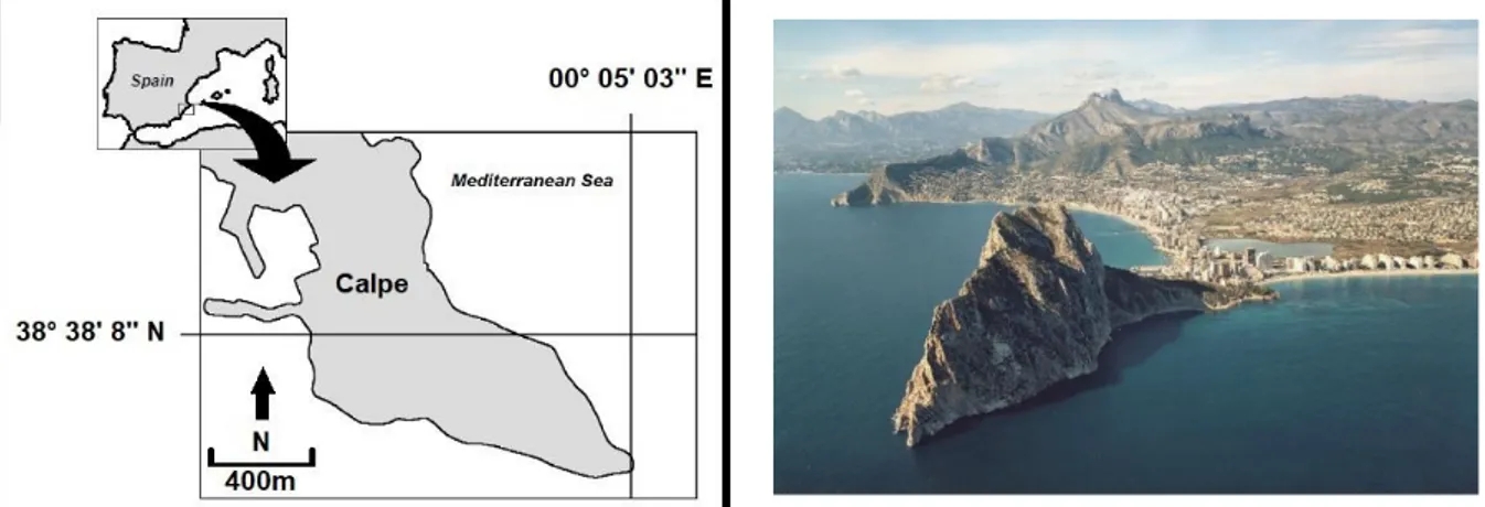
This study was carried out in the waters of the “Parque Natural del Peñón de Ifach”. Ifach's Crag (Penyal d'Ifac in Valencian) is located in the region of the High Sea-coast in Calpe's municipality in the province of Alicante (Spain) (Fig 3.1).
The Crag is 332 m above the sea level and has an area of 50.000 m2 (Fig. 3.2). This calcareous mountain was declared Nature reserve by the Decree 1/1987, January 19, of the Valencian Government. Only in 1993 has definitely been approved the plan of management of the park that currently extends for a total of 53,3 acre and it is entirely terrestrial. The surrounding marine area to the mountain has recently been declared special protection area (SPA) under the Birds Directive (79/409/CEE), while no protection plans have been implemented for the marine area. On both sides of the natural reserve, there are opened beaches of thin sand: "Levante" or " La Fossa " towards North; “Cantal Roig” and “Arenal‐Bol” towards South, which, together with "Morro de Toix", shape the coastline of Calpe's bay (Fig. 3.3).
Figure 3.1. Geographic location of the study area. Figure 3.2. View of the Peñón de Ifach from the sea.
23 3.1.2 Geological context
Ifach's Crag is the last spur of the Baetica mountain chain (Andalusia) and is part of the internal delimiting of the mountain chain called Prebética. The compressive efforts in the Prebetic sector formed the basin that was refilled by Miocene’ marine materials among those who inserted big fallen blocks (olistoliths) proceeding from the top part of the folds of Oltà's Saw. The olistolith of Ifach's Crag (limestones eoceno-oligocenas) finished resting on the younger miocenas marls. In the Eocene - Oligocene, approximately 65 millions of years ago, the place that today occupies the Crag, was a marine slightly deep platform in which were going settling the remains of fossils. 14 million years ago an intense orogenic phase took place forming big faults of orientation, responsible for the collapse under the sea of the sectors placed between Morro de Toix and Ifach's Crag. In addition, big blocks of land emerged to the surface (olistoliths). The most recent materials are a consequence of the coastal deposition in conditions of marine slow and continued regression, these are dune cords that do not appear on the surface. The crag is joined to the continent by a detrital isthmus, which is a sedimentary environment recent littoral. Approximately two million years ago, the sediment proceeding from the rivers and from the erosion of the cliffs formed a tongue connection for the action of the coastal dynamics (Fig. 3.4). Between the island and continent there existed a slightly deep strait that went away for sandy contributions brought by the currents parallel to the coast, giving origin to two sandy tops of the coastal arrow (now cemented sandstones). At the same time the wind action accumulated contributing materials forming a
dune cord that isolated in the interior a zone flooded with salt waters, result of the mixing of continental waters with the sea. Therefore the Salt mine is a part of a former bay closed by the formation of this transverse cord dune to the surge. Nowadays it is possible to see this barrier of fossil dunes between Arenal and Cantal Roig beach. Another part of the barrier would be
in the La Fossa beach. Figure 3.4. Formation process of the Salt mine and the isthmus that
24 3.1.3 Marine context
The seabed adjacent to the mountain is very heterogeneous in relation to the mountain orientation (Fig. 3.5).
The depth gradient is really marked in the south/southwest zone of the Peñón de Ifach, where it quickly reach -35 m. On this side of the mountain, there is a beach of pebbles (Racò Bay) along the depth gradient gives gradually step to different biocenosis of thin sands. On this side of the cape, a great P. oceanica meadow is present, which extends from -6 m to -22 m depth. The sector north of the Peñón de Ifach, however, has vertical walls at the base of which great calcareous blocks are located coming from the detachment of the walls of the same mountain. On this side, there is a really big sandy beach (La fossa beach) beginning from which the sea floor goes deeper very slowly. From this side of the mountain, there are two different meadows of P. oceanica, one directly in front of the beach constituting a structure like a reef, while the other is situated on the north slope of the mountain.
The waters that surround the Peñón de Ifach are protected from wind and surge principally in his west and north faces due to the geographical protection that he is awarded by the saws of Oltá, Bernia and Mascarat. In turn, the sectors south and North-East are the most exposed to climatic phenomena of this type being the most frequent proceeding from this side.
The whole area is affected by a variety of anthropic pressures, most of which are related to tourism. From June, the number of tourists that reach the area and that consequently crowd the beaches, reaches exorbitant numbers. Also the number of boats that anchor in the bays increase
25
very much in summer, going to constitute a probable threat for the P. oceanica meadows, also because there are no buoys to attach to, instead of anchoring.
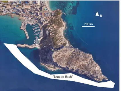
Behind Cala Racò bay is located a fishing port that does not directly affect the area, but has done it in the past. The fishermen comment that up to a couple of decades containers did not exist to throw the garbage in the
fishing port and that the garbage of major size, gathered by the trawlers, was beginning to be thrown into the Cala Racò area, the so-called “Brut de Ifach” (García-March et al., 2015) (Fig 3.6). In this way, for many years there was spilled all kinds of residues of large size, from ropes up to girders, containers and
fishing tackles. Some remains have joined the bottom and on them, numerous incrusting organisms and P. oceanica have grown, but the majority perceive it as a problem from the environmental and aesthetic point of view. It would suit to solve by means of a professional cleanliness of the funds, coordinated with scientists, to minimize the ecological impact of the own extraction of the garbage.
3.2 Physical descriptors
3.2.1 Water conditions
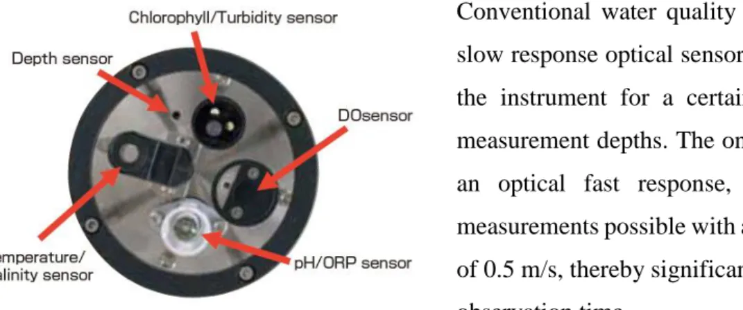
To monitoring the physical-chemical parameters of the water, such as temperature, turbidity and dissolved oxygen a
multi-parameter CTD probe has been used, AAQ-RINKO (LFE Advantech Co., Ltd.) (Fig. 3.7). It is connected, through a cable, to a hand-held unit that records the measured parameters, returning the profiles along the water column.
Figure 3.6. "Brut de Ifach" mapping from García-March et al. (2015).
26
Conventional water quality profilers with a slow response optical sensor require holding the instrument for a certain period at the measurement depths. The one we used, with an optical fast response, makes vertical measurements possible with a profiling speed of 0.5 m/s, thereby significantly reducing the observation time.
The data were collected once a month, for one year, up to -30 m depth, to have information related to the whole range in which the meadow of P. oceanica is distributed.
3.2.2 Sediment analysis
From October 2016, samples of sediment of around 300g were collected monthly, in three different stations (C01 -5m, C02 -10m, C03 -15m) of the Cala Racò meadow (Fig. 3.9.), with the purpose to analyze its particles size and to quantify in its variation in relation to the seasons, related to hydrodynamic conditions.
Figure 3.8. CTD probe sensors.
27
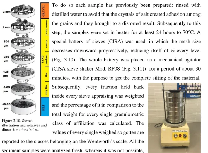
To do so each sample has previously been prepared: rinsed with distilled water to avoid that the crystals of salt created adhesion among the grains and they brought to a distorted result. Subsequently to this step, the samples were set in heater for at least 24 hours to 70°C. A special battery of sieves (CISA) was used, in which the mesh size decreases downward progressively, reducing itself of ½ every level (Fig. 3.10). The whole battery was placed on a mechanical agitator (CISA sieve shaker Mod. RP08 (Fig. 3.11)) for a period of about 30 minutes, with the purpose to get the complete sifting of the material. Subsequently, every fraction held back
inside every sieve appraising was weighted and the percentage of it in comparison to the total weight for every single granulometric class of affiliation was calculated. The values of every single weighed so gotten are reported to the classes belonging on the Wentworth’s scale. All the sediment samples were analyzed fresh, whereas it was not possible, they were frozen with the purpose to maintain their integrity.
Since granulometric distributions can be assimilated to Gaussian curves, the dimensional spectrum description follows the rules of classical statistical parameters. These "classics" can be integrated by a different index, which can be revealed graphically or by analytical methods from cumulative curves. These curves were constructed by adding each size class to the previous one, on the abscissa there were the values of the sieve diameter on a logarithmic scale (ø notation = - log2(mm), Tab. 3.1). From these curves, after calculating the values for the percentiles, it was possible to obtain the descriptive parameters (Folk and Ward 1957).
mm ø notation 2 1 0.5 0.25 0.125 0.063 <0.063 -1 0 1 2 3 4 5 Table 3.1 Conversion scale from mm to ø Figure 3.10. Sieves
illustration and relatives and dimension of the holes.
Figure 3.11. Agitator and sieves photo.
28
NAME MEANING FORMULA (Falk & Ward 1957)
Mdø Average diameter.
σ
Sorting or standard deviation of the sediment, represents the measure of dimensional variability within the sample. It gives information about the sediment classation.
Sk
Skewness, it represents the measurement of distribution symmetry. The values can range from -1.0 to +1.0. It provides information on the energy to which the sediment is subjected, and hence to the relationships between the dimensional classes that make it up.
K
It represents the measure of the slugness of distribution in relation to sorting. This parameter has a poor geological significance.
Fh
Hydrodynamic factor, allows estimating the mean value of the currents.
29
3.3 Monitoring Posidonia oceanica
Six monitoring stations were realized, four of which located in a single meadow on the South slope of the Peñón de Ifach mountain, and two situated in lists stains on the North side of the same mountain (Fig 3.12).
Every station of monitoring consisted of 6 points of sampling, in each of which a SCUBA diver team realized the corresponding measurements, along a transect 10 meters long (Fig 3.14).
The position of every sampling point were indicated by a metallic picket of 1,5 m of total length, fixed in the sediment and provided with a small buoy that stands out 1 meter above the leaves (Fig 3.14).
Figure 3.12. P. oceanica monitoring stations.
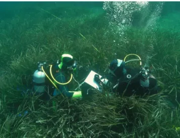
Figure 3.13. Members of the SCUBA diver team.
30
The pickets were numbered and distance between two adjacent pickets ranged between 3 and 6 meters (Sandulli et al., 1998), following the limits of the meadow, when presents, so that they could be used as reference for the monitoring regarding the expansion or the regression of the limit of the meadow during the years. The examples brought in literature to monitoring the lower limit of P. oceanica meadows foresee the use of bodies of reference, e.g. blocks of cement or metallic rods, that don't have the possibility to be moved by the hydrodynamic action (Buia et al., 2003). For each transect, the direction (in °) was recorded, in this way, every measurement can be repeated in the same place, at the time. The majority of the stations were located in correspondence to the lower limit of the meadow to show, eventually, first signs of degradation of the system. The typology of border has been defined following the classification of Meinesz and Laurent (1978) and Pergent et al., (1995).
Furthermore, for each meadow (A, B and C) it has been classified the Bed typology that together with the Limit typology constitute the physiographical descriptors of seagrasses meadows. The ecological status of the P. oceanica meadows was assessed investigating some structural descriptors:
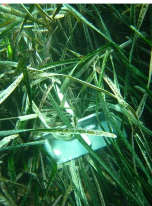
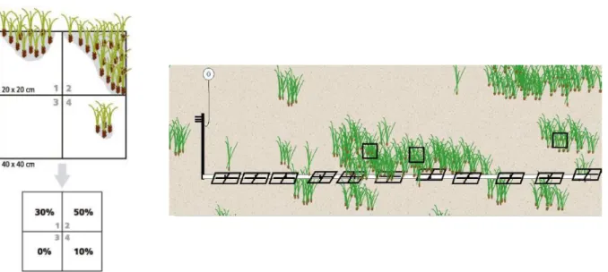
- Shoot density: is the number of seagrass shoots m-2 and thereby provides a measure of seagrass abundance along depth gradients. This descriptor was measured along every single transect three times, for a total of 18 measures each station, using a 25x25 cm PVC frame. These values were reconducted to a square meter. This variable represents one of the most important descriptors to appraise the status of a meadow, above all if measured on a multiannual temporal scale (Buia et al., 2003).
- Covering: is a measure of abundance, but expressed as a percentage. It consists in visual estimation of the percentage of the surface of the bottom occupied by the shoots of P. oceanica on a known area. Ten measures of this variable were conducted on each transect (one each meter), for a total of 60 measures in every station, using a 40x40 cm PVC frame. To facilitate the sampling, frames were subdivided into 4 subsquares of 25x25 cm. To each subsquare a value ranging from 0 % to 100 % was assigned according to the proportion of surface that was
Figure 3.15. Reference buoy connected to a picket.
31
occupied by the shoots (Fig. 3.16). All measures were done by two previously inter-calibrated operators.
From these two descriptors the Global density was estimated as the result of the product of the average density inside P. oceanica patches and the proportion covered by the meadow (Romero 1985).
- Burial: it is the vertical distance (in centimeters) between the level of the sediment and the ligule of the most external leaf of the shoot of P. oceanica. The value and sign of this distance changes depending on the balance among the vertical growth of the plant and the dynamics of the sediments in every site: it is positive (sediment level below the ligule line) if erosion processes are predominant, and negative (sediment level above the ligula) if an excessive accumulation of sediments exists on the meadow. The burial of the vertical shoots of P.
oceanica then is a symptom of erosion of the meadow. Both the erosion and the deposition of
sediment provokes an increase in the mortality of shoots of the meadow (Cabaço et al., 2008). The meadow to be healthy, the sediment must be stable or accumulate at low rates, so that the meadow could respond with an elevation rate of the substratum of few cm year-1 (Gacia and Duarte 2001). High rates of sediment deposition provoke the burial of the meadows. Accumulations of sediment superior to 10 cm provoke the mortality of shoots of 50 %, and when the burial of the rhizome exceeds 14-15 cm, the mortality of shoots is 100 % (Cabaço et al., 2008). To evaluate the burial of the shoots on the selected stations, the vertical distance (in centimeters) between the sediment and the lígula (meristem of growth) was measured in one of
Figure 3.16. Estimate of Covering structural descriptors of the P. oceanica meadow, along a transect of 10 m length (Marbà et al. 2015).
32
the external leaves of the bundle of P. oceanica. In every station these measures were realized 12 times each transect.
Furthermore, in each station 30 shoots were collected to proceed with the analysis of the morphology of the leaves. In this case, the functional descriptors analyzed were:
-Number of leaves/shoot -Leaves length
-Leaves width: measured around the middle of the leaf.
-Apex status: it can appear entire, broken or bitten from some herbivorous. It can be distinguished from the shape like in Figure 3.17.
From this synthetic descriptors can calculate the derived descriptors. They are:
- Leaf area average for shoot (cm2 shoot-1): for every shoot, the surfaces of all the leaf (an only face is considered) edges are calculated, therefore the gotten values are added for having the total area of the shoot and they are finally mediated for the number of sampled shoots.
- Herbivorous rate: how many leaves result vices herbivorous on the total one, directly derived from the analysis of the apex status.
- Leaf Area Index (m2 m-2): it is calculated multiplying the surface leaf average for shoot for the density of the meadow for each square meter.
- Coefficient "A": percentage of adult and intermediary leaves that has the apexes broken; it is calculated dividing the total number of adult and intermediary leaves with broken apexes for the total number of the observed leaves. The value of the coefficient "A" it is more often the result of some factors like the hydrodynamism, the age of the leaves and the level of presence of herbivores.
Figure 3.17. Herbivorous traces on P. oceanica leaves (Buia et al. 2003)
33
3.3.1 Statistical analysis
With the aim of verifying the small-scale variability, and therefore between the transects of each station, for the structural parameters, an ANOVA two-way nested was performed following the sampling design, using R statistical software. This statistical analysis was conducted after verifying the normality of data distribution with the Shapiro-Wilk test (p> 0.05) and the Levene test was used to confirm homogeneity of variances (p> 0.05).
34
4. Results
4.1 Physical descriptors
4.1.1 Water conditions
The water temperatures recorded in the water column throughout the year showed the seasonal pattern typical of temperate seas, with a minimum temperature of 14°C and a maximal one of 30.9°C (Fig. 4.1).
From October to February the temperatures recorded in the water column are homogeneous. Bearing in mind that there is no fresh water supply and having verified that at different depths even salinity remains homogeneous along the water column, it could be stated that during the winter season the water masses had equivalent density. Considering the condition of high hydrodynamism characteristic of that season, it could, therefore, be assumed that there was a complete reshuffle affecting the entire water column.
35
From February, with the advent of spring and hence rising air temperature, the structure of the water masses changed. In fact, from this time of year, a stratification process of water masses occurs, due to the superficial warming, which becomes increasingly evident in the summer season, where it became clear the thermocline at a depth around -15m (Fig 4.3).
Figure 4.2. Salinity time series along bathymetric gradient.
0 5 10 15 20 25 30 10 15 20 25 30 De p th (m) Temperature (°C) March May July
36
The establishment of the thermocline, together with the abundant rains of the early months of the year, induces a change in the density of water masses preventing its mixing; this is also evident in the salinity chart (Fig. 4.2) two distinct water bodies can be identified above and below -15m. There are hot waters with less salinity, less dense in the surface layer, and more dense deeper, colder and saltier waters below. At the end of the summer season, it is perceived by the data as the situation set up during the hottest period of the year, tends to return to the winter homogeneity with the thermocline breaking due to the strong hydrodynamic regime and the overall lowering of temperatures.
Another of the physical parameters under consideration was turbidity, in fact, under high conditions, it is one of the drivers that guide the distribution and density of the P. oceanica meadows. Values of this variable measured throughout the year were not high and were unlikely to be able to affect the health of the plant. The only spikes that occur during the winter season were related to isolated climatic events that have caused the particulate fraction present in the sediment to be brought back into suspension (Fig. 4.4).
37
Concerning dissolved oxygen values, two types of patterns could be observed (Fig. 4.5). Except for November, in accordance with the above, a uniformity of values for the entire water column occurred. The situation beginned to diffract with the approach of spring and hence the growth of phytoplankton on the shallower layers.
In fact, a large number of primary producers attracts its direct predators, zooplankton. These microorganisms, located in the same bathymetric band of their prey, tend to consume large amounts of oxygen, resulting in a decrease of it in surface concentrations (Gilly et al., 2013). The great difference with the deep oxygen concentrations during the summer season was always due to the presence of the thermocline that prevented the mixing of water, but was further accentuated by P. oceanica's oxygen production peaks that are highest in the summer.
Figure 5.4 Turbidity time series along bathymetric gradient.
38 4.1.2 Sediment analysis
From a preliminary visualization of the results gotten by the size particle analysis of the annual series of the samples of sediment, it emerges that in all the three stations, the dominant dimensional class is sand (Wentworth scale 2-0.063 mm).
The analysis of the annual series of sediment samples has initially been investigated through the use of the ternary diagram of Shepard (1954), graphically represented using Grapher 9 software, that brings on the sides of a triangle the data ponder them some different granulometric fractions and it has the purpose to classify the sediment in groups that have different ecological meaning in relation to where they are placed. With this typology of analysis the picked samples in the three stations lasting the whole arc of the year show to be very similar among them and to belong all to the category of sands (Fig. 4.6, 4.7, 4.8).
39
Figure 4.7. Shepard triangle for C02 sampling station.
40
The following ternary diagram has been made, derived by the first one, which brings a different classification, with the purpose to show the possible heterogeneities among samples, therefore having a pure descriptive value. The weights of each dimensional class separated with the sieves were declassified in different dimensional categories within the group of sands (Coarse sand >1mm, medium sand 1-0.250mm, fine sand < 0.250mm), considering that they constitute around the 90% of the total weight in all samples. Also in this case samples are results to be very homogeneous inside the same stations during the whole year (Fig. 4.9, 4.10, 4.11).
41
Figure 4.10. Sands classification triangle for C02 sampling station.
42
The variability during the year, inside the stations at different depth, has been investigated using the weights related to every level of the battery of sieves in relationship to the time. With such subdivision, following the calculation of the Pearson’s correlation index, meaningful tendencies to temporal variation does not appear, for the C01 and C03 station, while instead meaningful results are gotten by the analysis of the C02 station. At C02 a positive correlation between time and sediment fraction of 0.5mm, and a negative correlation between time and sediment >0.5mm was found. During the year, from the winter toward the summer, there is, therefore, a situation of increase of thin sand and a diminution of coarse sand.
Everything seems to point out that in the C01 and C03 stations, in the whole arc of the year, there is a rather stable sediment structure suggesting that hydrodynamism is not particularly subject to seasonal variations, while the C02 station, show a correlation between time and different dimensional classes and therefore a temporal pattern.
The initial hypothesis of seasonal variation in the sediment particle size, seems denial for the superficial and deep station, but not for the intermediary one, but to affirm it with certainty further studies replicated in time are needed.
Proceeding with the results of the granulometric parameters, giving them information on the hydrodynamic conditions, they confirm a condition of elevated/medium hydrodynamism in the first and third station and a scarce/weak hydrodynamism in the intermedite one during the whole year. Besides, it appears clear that in the three stations the absence of a selective agent, contributes to a bad classation of the sediments (Tab. 4.1).
The peculiar hydrodynamic situation in the zone C02 should subsequently be investigated. It could be that P. oceanica meadow, reducing the energy of the waves, already less intense in the summer period, facilitates an appropriation of the thin particles in this zone.