Dipartimento di Informatica
Dottorato di Ricerca in Informatica
SSD INF/01
Ph.D. Thesis
Reliable & Efficient Data Centric Storage
for Data Management in Wireless Sensor
Networks
Michele Albano
Supervisor Stefano Chessa
May 21, 2010
Department of Computer Science University of Pisa
First of all, I want to thank my supervisor Stefano Chessa for the unvaluable col-laboration we had during these years, and all his help in writing this dissertation.
My gratitude goes to many more people, to Laura Ricci for being an advisor for my other research topic, and a friend, to all my co-authors, to Roberto di Pietro for being a source of ideas and reachable 24/24 and 7/7 (do you ever sleep Roberto?), to Pierpaolo Degano for being the chairman of a great PhD programme, to Marco Bellia, Chiara Bodei, Giovanni Manzini, Vincenzo Gervasi and Susanna Pelagatti for their help in becoming a better teacher, to Maria Rita Lagan`a and Marco Maria Massai for the exciting experience I had at the science fair “Ludoteca Scientifica”, to my mates snacks (automatic translation of “compagni di merende”) Daniele Sgan-durra, Davide Cangelosi, Igor Nitto, Rossano Venturini, Razvan Popescu, Giovanni Pardini and Andrea Lorenzani, to Jie Gao and Rik Sarkar for hosting me at their University and for working with me on interesting problems, to Hongyi Wu for pro-viding valuable hints to prepare a better PhD thesis. I am sure I forgot someone, so thank you for forgiving me for forgetting you.
Finally, a deep thanks to my family, to Andreina and to my friends. Without your support, I would not have made it to here!
1 Introduction 9
1.1 WSN applications . . . 10
1.2 Abstractions and mechanisms for WSN middleware . . . 12
1.3 Goals of the Thesis . . . 13
2 Related Work 15 2.1 Network layer . . . 17 2.1.1 Routing trees . . . 18 2.1.2 Geographic routing . . . 19 2.1.3 Virtual coordinates . . . 21 2.1.4 Hierarchical routing . . . 22 2.1.5 Gossiping mechanisms . . . 23
2.2 Data Management layer . . . 24
2.2.1 Local and External Storage . . . 25
2.2.2 In-network storage and Data Centric Storage . . . 27
2.3 Programming Abstraction layer . . . 38
2.3.1 Global Entity . . . 40
2.3.2 Local Entities . . . 43
2.4 Dependability mechanisms . . . 51
2.4.1 Pure replication . . . 52
2.4.2 Erasure coding . . . 52
3 Data Centric Storage 55 3.1 Load Balancing and Non Uniformity in DCS . . . 56
3.1.1 Load unbalance in DCS-GHT . . . 57
3.1.2 A Novel Protocol for Data Centric Storage . . . 63
3.1.3 Simulations . . . 68
3.2 Data Centric Storage in ZigBee Wireless Sensor Networks . . . 73
3.2.1 The ZigBee network model . . . 73
3.2.2 DCS over ZigBee . . . 76
3.2.3 Z-DaSt protocol analysis . . . 81
4 Erasure Coding for Data Management 87
4.1 Distributed erasure coding in DCS . . . 88
4.1.1 The in-network storage model . . . 89
4.1.2 Data Dispersal & Retrieval based on Erasure Codes . . . 91
4.1.3 Probabilistic Model . . . 92
4.1.4 Cases of study . . . 94
4.1.5 Memory overhead . . . 101
4.2 Resilient Storage for Efficient Mule Collection . . . 103
4.2.1 In-network Coding by Spatial Gossip . . . 106
4.2.2 Data Recovery and Mule Collection . . . 108
4.2.3 Simulations . . . 110
5 Conclusions 119
Wireless Sensor Networks (WSNs) have become a mature technology aimed at per-forming environmental monitoring and data collection. Nonetheless, harnessing the power of a WSN presents a number of research challenges. WSN application devel-opers have to deal both with the business logic of the application and with WSN’s issues, such as those related to networking (routing), storage, and transport. A middleware can cope with this emerging complexity, and can provide the necessary abstractions for the definition, creation and maintenance of applications.
The final goal of most WSN applications is to gather data from the environment, and to transport such data to the user applications, that usually resides outside the WSN. Techniques for data collection can be based on external storage, local storage and in-network storage. External storage sends data to the sink (a centralized data collector that provides data to the users through other networks) as soon as they are collected. This paradigm implies the continuous presence of a sink in the WSN, and data can hardly be pre-processed before sent to the sink. Moreover, these transport mechanisms create an hotspot on the sensors around the sink. Local storage stores data on a set of sensors that depends on the identity of the sensor collecting them, and implies that requests for data must be broadcast to all the sensors, since the sink can hardly know in advance the identity of the sensors that collected the data the sink is interested in. In-network storage and in particular Data Centric Storage (DCS) stores data on a set of sensors that depend on a meta-datum describing the data. DCS is a paradigm that is promising for Data Management in WSNs, since it addresses the problem of scalability (DCS employs unicast communications to manage WSNs), allows in-network data preprocessing and can mitigate hot-spots insurgence.
This thesis studies the use of DCS for Data Management in middleware for WSNs.
Since WSNs can feature different paradigms for data routing (geographical rout-ing and more traditional tree routrout-ing), this thesis introduces two different DCS protocols for these two different kinds of WNSs. Q-NiGHT is based on geographical routing and it can manage the quantity of resources that are assigned to the storage of different meta-data, and implements a load balance for the data storage over the sensors in the WSN. Z-DaSt is built on top of ZigBee networks, and exploits the standard ZigBee mechanisms to harness the power of ZigBee routing protocol and
approaches employ replication as the mean to ensure data availability. A possible enhancement is the use of erasure coding to improve the persistence of data while saving on memory usage on the sensors.
Finally, erasure coding was applied also to gossiping algorithms, to realize an efficient data management. The technique is compared to the state-of-the-art to identify the benefits it can provide to data collection algorithms and to data avail-ability techniques.
Introduction
In the last few years, hardware and software innovations have been leading Wireless Sensor Networks (WSNs) from the research labs to deployments in real contexts.
A WSN application is a distributed application that is built on a large number of low-cost, low-power, battery-powered sensors[1, 2, 3]. Sensors are spread in an environment (sensor field ) without any predetermined infrastructure and cooperate to execute common monitoring tasks which usually consist in sensing environmental data and monitoring a variable set of objects. The sensed data are collected by an external sink node, when connected to the network. The sink node, which could be either static or mobile, is in turn accessed by the external operators to retrieve the information gathered by the network.
The design of WSN applications is challenging since they have to deal with their own business logic, and with the issues that naturally arise when WSNs are taken into account, such as network formation, data transport and data management, security and energy saving. This last requirement arises since nodes are typically battery-powered, and the energy budget of the nodes is limited, hence energy saving techniques are to be implemented to avoid energy starvation and the subsequent death of nodes. Dealing with these issues can be done either explicitly, thus adding complexity to the applications, or implicitly by means of a middleware, that is a software layer that abstracts from common issues of the WSNs. For example, sensed data transmission can be implemented on top of 802.15.4 MAC-level send/receive operations, or an abstraction layers can offer a transparent routing layer. In the latter, the particular routing protocol that is used becomes a middleware parameter, and the application developer can switch between different routing mechanisms at network creation time, instead that at application design time. Distilling a given high-level behavior from a set of sensors is a challenging problem, especially when explicitly dealing with WSN issues, since the complexity can be overwhelming.
In this thesis, the goal of WSN middleware is to deal with WSN issues. On the other hand, there is no unique way to define which issues belong to the WSN, and which ones are part of the business logic. In general, this depends on the poli-tics/mechanisms dichotomy, and hence on the level of abstraction that is provided
by the middleware. Even a minimal middleware can provide benefits to the applica-tion developer, nonetheless it presents research challenges. For example, one of the first middleware that was studied is based on directed diffusion[74, 154], that is a routing mechanism where a special node of the WSN, called the sink, broadcasts an interest in the data, creating a data collection tree that is used to route all the data that are produced towards the sink. Directed diffusion provides the user application a data collection mechanism that is easier to use than explicitly moving all the pieces of data towards the sink.
Complex scenarios can arise in WSN applications, and a number of theoretical and practical problems blossomed when the level of the abstraction of the mid-dleware was deeply pinpointed. This thesis aims at analyzing some of them. For example, if an application wants to deliver data to more than one sink, or if the sink is inaccessible for some time, it can be useful to cache data into the network before sending them to the user application. From this scenario, Data Centric Storage (DCS)[87] was born. The paradigm states that data are stored inside the network, in a subset of the sensors that is dependent on a meta-datum that describes the data, and the sinks query the WSN to retrieve the data they are interested in. DCS in general is considered as a useful mechanism to decouple data production from data collection, and it is the central topic of the research work described in this thesis.
1.1
WSN applications
A large number of low-capacity sensors must be orchestrated into a common behavior to give support to complex WSN applications. Despite the complexity that must be faced during the development, several kinds of applications are supported by WSNs, since they are flexible enough to be applied in diverse areas, such as:
• Environmental monitoring. Monitoring of the effects of industrial plants on the environment is a key issue in different application domains and particu-larly in the field of nuclear energy[15]. In “precision agriculture”, [16] shows that sensing moisture in soil and fertilizer absorption (combined with video surveillance) can significantly increase crop yield and optimize water use. Sep-arately, trends and patterns in the Great Barrier Reef[17] may get Australian government sponsorship for sensor-based monitoring to halt spread of invasive species. In transportation, [18] considered using WSNs to monitor traffic, for example to allow other traffic into bus lanes when there are no buses, with the goal of increasing traffic flow.
• Critical Infrastructure Protection. According to the European Commission, Critical Infrastructures consist of “those physical and information technology facilities, networks, services and assets which, if disrupted or destroyed, would have a serious impact on the health, safety, security or economic well-being
of citizens or the effective functioning of governments in the Member States. Critical Infrastructures extend across many sectors of the economy, including banking and finance, transport and distribution, energy, utilities, health, food supply and communications, as well as key government services”[19]. The threat of contaminant intrusion due to leaking pipes [20] or malicious human action will further increase the projected expenditure. Repairing and securing this infrastructure requires large investments of money and time, and therefore, it is essential to direct efforts to upgrading critical areas[152, 153].
• Home systems and health monitoring. A “smart house” is usually made up of several intelligent devices that can control home appliances or “feel” their surroundings[21], and it can feature devices that intermix control on “intel-ligent” furniture and that monitor user position and/or state. This kind of infrastructure can lead to applications supporting rehabilitation after illness, such as providing assistive technology for cognitive rehabilitation[25] and in-dependent aging. For example, the European project PERSONA[22] aims at advancing the paradigm of Ambient Intelligence through the harmonization of Ambient Assisted Living (AAL) technologies and concepts for the development of sustainable and affordable solutions for the social inclusion and independent living of Senior Citizen. The iDorm project[23] has studied the feasibility of automated living environments, and in particular has realized a campus dorm environment. The Monica project[24] has developed a system that identifies gestures and activities in order to retrieve and project needed information in a workplace environment.
• Surveillance, and Inventory Management. Companies are developing WSN technologies to address security scenarios, and industrial applications. For ex-ample, Motorola’s MERL project[26] has been investigating network protocols that help conserve node battery power. Their technique incorporates a node’s residual energy into the cost metric that is computed when determining what route to send packets on. The applications for such networks include inventory management, product quality monitoring, factory process monitoring, disaster area monitoring, biometrics monitoring, and surveillance.
• Architectural support for applications of pervasive computing. For example, Amigo project[27] aims at overcoming the obstacles to widespread acceptance of home networking technology, by developing open, standardized, interopera-ble middleware and attractive user services, thus improving end-user usability and attractiveness. The goals of the projects are to addressing everyday life user aspects: home care and safety, home information and entertainment, and extension of the home environment by means of ambience sharing for advanced personal communication. The Amigo project aims at supporting interoperabil-ity between equipment and services within the networked home environment
by using standard technology when possible and by making the basic middle-ware (components and infrastructure) and basic user services available as open source software together with architectural rules for everyone to use.
Middleware based on DCS can provide advantages to applications belonging to different application areas of WSNs for several reasons. In particular DCS decouples data producing and data consuming[28], hence empowering the application devel-oper with a structured model for application design. Moreover WSNs can leverage on innetwork storage to deliver data to an external application even in scenarios where the WSN operates unattended, i.e. when sink is not present in the WSN for part of the WSN lifetime[29]. Finally, critical applications can be deployed in ex-treme environments, where sensors can be prone to faults[30], and DCS can exploit different data storages mechanisms to provide data availability to the application, hence preserving the data in front of sensor faults.
In particular, considering the application areas described in this section, an ad-vanced design based on decoupling between data producing and consuming can deliver benefits to smart houses and applications of pervasive computing, since it can simplify the integration of application modules developed by different parties; environmental monitoring and surveillance can exploit unattended WSNs to col-lect data from the environment; critical data colcol-lection can leverage on the data availability features offered by DCS to save data when a subset of the sensors is lost.
1.2
Abstractions and mechanisms for WSN
mid-dleware
The level of abstraction provided by a WSN middleware inherently depends on the mechanisms that are used by the middleware to implement the high-level primitives. The analysis of state-of-the-art mechanisms was developed into a structured vision of the mechanisms, that were organized into three layers (Programming Abstraction layer, Data Management layer, and Network layer) whose mechanisms can interact with each other or can be used directly by the application, plus a set of Depend-ability mechanisms that is orthogonal to the layers and that comprises mechanisms that are used by all the layers and by the user applications alike. Further informa-tion about this classificainforma-tion will be provided in Chapter 2, that discusses related work, aside by presenting in Figure 2.1 a graphical representation of the layers or-ganization. Examples of them are mobile agents[67] and database[31] abstraction for the Programming Abstraction layer, DCS[87] for Data Management, GPSR[94] and MAP[96] for the Network layer, and pure replication (like in [87]) and erasure coding (like in [160]) for Dependability.
The results that will be portrayed in this thesis are related to DCS, that is based on a simple statement: data are more important than the single sensor. This implies that a sensor’s identity is less important than data identity, and it causes a shifts
from the classical paradigms (a sensor A produced datum d) to a data-centric one (a sensor in location x produced datum d with meta-datum D). DCS is based on the assumption that meta-data are globally known, hence they can be the input to a function that decides which sensors are prone to storing produced data. The most widely studied DCS system, Geographical Hash Tables[87] (DCS-GHT), concretizes this paradigm into a system where a meta-datum that describes a set of data is hashed into a geographical location L into the sensing region, then data are stored on all the sensors located onto around L in the planarized version of the WSN’s topology.
This thesis discusses Data Management mechanisms based on DCS. WSNs can be broadly categorized for paradigms for data routing that is used: location-centric WSNs use geographical routing protocols, like GPSR[94], to send data towards a geo-graphical coordinate in the WSN, while traditional routing routes data to nodes (see for example AODV[101] used in ZigBee networks[58]). Hence, this thesis introduces two novel DCS protocol, one for each of these two different kinds of WNS routing paradigm. Q-NiGHT is based on geographical routing, it manages the quantity of resources that are assigned to the storage of different meta-data, and it implements a load balance for the data storage over the sensors in the WSN. Z-DaSt is built on top of ZigBee networks, and exploits the standard ZigBee mechanisms so as to harness the power of ZigBee routing protocol and network formation mechanisms. Finally, Dependability mechanisms based on erasure codes are applied to the Data Manage-ment layer, to provide a better data availability for DCS, and to realize a faster and more reliable data collection when used together with a gossiping protocol.
1.3
Goals of the Thesis
This thesis analyzes the level of abstractions that can be provided by current WSN mechanisms, and considers the use of novel mechanisms to expand current capabil-ities of WSN middleware.
As previously stated, a middleware that is based on DCS would represent a novelty into the WSN scene and could expand current WSN limitations, by means of offering a novel structure to application designer for decoupling of data produc-ing and consumproduc-ing, allowproduc-ing applications to operate while the sink is missproduc-ing, and offering data availability.
On the other hand, applications would still suffer from the limitations given by the DCS system in use. With most current DCS systems, for example with Geographic Hash Tables (DCS-GHT ) that is its most studied implementation:
• the set of the sensors that store the data depends on the topology of the WSN, and it is not selectable by the WSN application developer
• Dependability is ensured by means of pure replication, in the sense that all the sensors in the set that must store a given meta-datum must store a copy
of the datum.
These features imply that DCS uses sensors’ memory in an unpredictable way, and that most important data cannot receive higher data availability than less im-portant data. Moreover, pure replication wastes storage space with respect to more advanced techniques, for example based on erasure codes. While a WSN testbed would be able to operate for a short time without incurring in faults or memory depletion, a real deployment of a WSN that should operate for a long time would benefit from techniques that can
• manage memory used for different data, providing QoS to data storage • reduce storage memory within a given level of data availability.
Organizing this research using the layers introduced in Section 1.2, the goals of the thesis are to
• introduce Q-NiGHT and Z-DaSt, that are novel DCS protocols providing QoS capabilities for data storage and present good load balancing. Q-NiGHT is similar to DCS-GHT, and it fits WSNs using geographical routing. Z-DaSt is designed to be used on WSNs that are based on the ZigBee standard.
• review current Dependability mechanisms used for WSNs, and introduce a new way of exploiting erasure coding that can enhance the Data Management layer without increasing the complexity of DCS;
• propose a novel Data Management layer mechanism that combines gossip rout-ing and erasure codrout-ing to disseminate data in a WSN in an efficient way.
Related Work
Current research papers agree that one of the critical points to leverage on the po-tential usefulness of WSNs is the possibility of abstracting common WSNs problems by means of convenient middleware, but literature is not coherent when defining what a middleware is[4, 5, 151, 6, 7, 8, 9, 10, 11, 12, 13, 14].
To define what a middleware is, I will focus on the goals that a middleware has to achieve. The main purpose of middleware is to support the development, maintenance, deployment and execution of applications, filling in the gap between the application layer and the hardware, operating system and network stacks layers. In the case of WSNs, this can include mechanisms for formulating complex high-level sensing tasks, communicating this task to the WSN, coordination of nodes to split the task and distribute it to the individual nodes, data fusion for merging the sensor readings into high-level result, and reporting it.
The actual analysis of state-of-the-art middleware presented a variety of different techniques and approaches used to address the aforementioned goals. In fact, WSN systems offer functionalities that can be collectively called “middleware” but that are very different from each other. For example, different middleware offer
• low-level mechanisms that operate at packet level, such as routing protocols[94, 159, 96]
• abstract mechanisms that hide the single datum, like database-like systems[31, 33]
• service oriented architectures, for example the ZigBee standard[1] • platforms for mobile agents, for example AFME[70] or Agilla[67]
This analysis of the state-of-the-art mechanisms identified three layers (Pro-gramming Abstraction layer, Data Management layer, and Network layer), and the mechanisms are categorized in terms of this structure. The mechanisms can interact with each other or can be used directly by the application. A set of mechanisms for
Figure 2.1: Middleware is structured as a set of layers between the hardware and the application.
Dependability was also identified, and it can be used at different levels for different purposes. Figure 2.1 provides a graphical representation of this structure.
Programming Abstraction layer comprises the mechanisms that models the be-havior of the whole WSN, and that provide the user application with mechanism to abstract the WSN details. For example, a user application can perceive a WSN as a relational database[31, 33], as a publish/subscribe system[158], as a service oriented architecture[1], or as a platform for mobile agents[70].
The Data Management layer lets the user perform store and retrieve operations on data, either storing them on a specific sensor or set of sensors, or selecting the set of sensors from a meta-datum of the data to be stored or retrieved, as in Data Centric Storage systems[87, 159, 110].
The Network layer features explicit send and receive operations, and lets the user application control the transmissions performed at a finer grain. This layer nonetheless performs some abstraction, since it hides the routing protocol used, hence it lets the invoker specify the goal of the routing process, be it a sensor or a coordinate in the sensor field.
The Dependability mechanisms regard the techniques used to create reliable primitives on the layers, and are used by all the layers alike. For example, DCS systems (Data Management layer) can use pure replication, or gossiping routing can perform erasure coding on data to speedup the data dissemination process.
A user application can rely on one of these layers, depending on the level of abstraction required, by addressing the whole WSN using the abstraction provided by the Programming Abstraction layer, or by performing explicit Data Management specifying which data are stored and retrieved, or it can be based on network level send/receive operations.
As an example of interaction of these layers, the Publish/Subscribe system de-scribed in [158] is based on a Data Centric Storage layer provided in [156]. The DCS mechanisms such as [87] used geographical routing such as [94] (Network layer) to transport data and queries to proper sensors. Erasure coding (Dependability mech-anisms) was used to guarantee data availability in [160] and to optimize access to data in [140].
2.1
Network layer
The wireless medium is inherently unreliable and WSNs do require robust routing protocols. The particular nature of the sensors requires the routing protocols to be tailored towards power saving and self-management. Another critical requirement is scalability, since WSNs may comprise up to thousands of sensors, hence basing route discovery on broadcast limits the scalability of the system.
Routing protocols for WSNs should also be lightweight in both processing power and memory footprint and should require minimal message overhead. Ideally they should be able to route packets using only information exchanged by a node within its neighborhood and they should be resilient to node failures and frequent topology changes.
The figure 2.2 describes how routing protocols can be differentiated depending on the features that are used during the execution of the routing.
Traditional IP-based
Traditional routing protocols for IP-based networks impose a hierarchical addressing structure on the network and base routing decisions (i.e., packet forwarding) on the destination address and a set of tables indicating the next hop for reaching that address. In a WSN environment, where nodes can be deployed at random and in large quantities and the network topology may vary due to sensor failures or energy efficiency decisions, assigning and maintaining hierarchical structures is impractical. The message overhead to maintain the routing tables and the memory space required to store them is not affordable for the energy and resource constrained WSNs. Routing for Ad-Hoc networks
WSN routing protocols originate from ad-hoc protocols, like Ad-hoc On Demand Vector Routing (AODV)[101] and Dynamic Source Routing (DSR)[102]. These re-active protocols contribute to alleviate traditional IP-based routing, but do not scale to very large networks since they depend on flooding for route discovery.
AODV is an on-demand route acquisition system. The WSN has a set of trans-mission paths that are actively routing packets, characterized by the endpoints of the route. The nodes store only data that refer to these active paths, and when a node needs to reach a node for which it has no route, it generates a broadcast transmission. The first packet that reaches the destination is sent back along the route it followed, setting up route pointers in the intermediate nodes. A packet sent along the route needs only to state its destination, since the intermediate nodes have pointers towards the next and previous steps along the route between the two endpoints. After some time a route is not used, the data related to it, is flushed, to free the memory from old and/or unused routes.
DSR approach is different. It is based on source routing and it does not store data on intermediate nodes. When a nodes needs a route for a destination, it broadcasts a packet. The packet is relayed through the nodes and it keeps trace of the hops it performs. The the destination receives the packet, it sends it back using the information it contains, so that the node that initiated the broadcast receives a valid route towards the destination. DSR’s approach does not need to store data on intermediate nodes in the WSN, but on the other hand it relays on source routing and its packets need to contain the sequence of the hops to perform to get to the destination, and hence the packets can get quite large.
2.1.1
Routing trees
Even simple data gathering applications need some kind of routing to transmit readings collected by sensors to the sink, possibly with some aggregation along the path.
trees[118]. A single sensor (usually the sink) broadcasts its interest in data, and as the request propagates through the WSN, each node just remembers its parent toward the broadcast originator, in such a way that the global structure is that of a tree. When a sensor needs to send data up the tree towards the sink, it sends them towards its parent in tree.
A refinement of this paradigm is the routing tree, used in Directed Diffusion[74, 154]. Data are named by meta-data that describe them, then the data consumer (a sink) injects a request for named data (called interest) into the WSN by means of a broadcast. The interest instructs the sensors to send any data matching with the interest to the sink. Interest dissemination sets up a routing tree rooted in the sink, and this tree is used to route the data.
Routing trees are very easy to construct and maintain but this approach is not suitable for more complex applications that require end-to-end communication.
2.1.2
Geographic routing
Geographic routing naturally supports end-to-end communication. The paradig-matic protocol for this kind of routing is Greedy Perimeter Stateless Routing (GPSR), that was introduced in [94].
In GPSR, all nodes are assigned a location according to some coordinate system and a distance is defined for any two locations. Each node periodically broadcasts its location to its local neighbors.
The routing is composed by two operation modes, greedy and perimeter, that are repeated until the destination is reached. One operation mode is the greedy for-warding. The second operation mode is the recovery mode used to grant guaranteed delivery to the protocol.
Greedy Routing means that, on the basis of the destination location (carried in each data packet), a node forwards the packet to the neighbor that minimizes remaining distance (compass routing[117], is a similar algorithm that chooses the next hop as the neighbor with the smallest angular distance to the destination). Although greedy routing is extremely simple and quite effective, some problems have to be solved:
1. what happens when greedy routing fails. Greedy routing alone cannot guar-antee delivery in every possible network topology. Resorting to flooding solves the problem but at a high cost. The solution is to integrate greedy mode with a special fallback mode that is entered when greedy mode fails.
2. how a node learns about its coordinates. This can be considered a localization problem, that involves assigning a tuple of coordinates to each node. An obvious possibility is to use a physical (geographical) coordinate system with nodes equipped with GPS (or manually configured) or let nodes approximate
Figure 2.3: GPSR routing around a void region.
their physical position from connectivity information with only a few GPS-equipped anchor nodes. An alternative to real coordinates is to run a protocol that assigns virtual coordinates to all the nodes[95].
A fallback mode for geographical routing is the one employed by GPSR. If the packet reaches a node whose neighbors are all farther than itself to the destination (i.e. it finds a void region), GPSR switches to the perimeter mode. In perimeter mode, a packet is forwarded in the planarized topology in order to turn around the void region. In this mode, the packet is forwarded clockwise along the nodes be-longing to the perimeter surrounding the void. For this purpose GPSR periodically computes a planarized topology of the WSN by using a distributed computation of the Gabriel Graph (GG)[98] or of the Relative Neighborhood Graph (RNG)[97]. The perimeter mode procedure traverses faces in planar graphs ([87] introduced this concept) and it ends when greedy routing are able to safely take over again (e.g., the current node is closer to the destination than the node where greedy routing failed). Two-dimensionality of the graph is mandatory since the face traversal mode is applicable only to planar graphs (i.e., having no intersecting edges). If the desti-nation (x, y) does not correspond to any sensor, the perimeter mode of GPSR goes around (x, y) and locates the closest sensor to the destination, that is called the the home node for (x, y).
Figure 2.3 shows an example of GPSR execution. Source is routing a packet to Destinationand it routes the packet to node A and then B using the greedy mode. Since B is closer to Destination than any of its neighbors, it switches to perimeter mode. Afterwards, the packet reaches node D that is closer to Destination than the perimeter mode initiator, hence the routing is switched back to greedy mode and the packet reaches Destination.
Although geographic routing is likely to contribute to reducing the routing over-head on the sensors, it requires that the sensors be aware of their location. There are scenarios where GPS is considered too expensive with respect to the target ap-plication or because it is not available at all (note that popular sensor platforms provide GPS only as an option [115]), or in the cases where the location information of the sensors is unsuitable to support geographic routing (for instance in a domotic
environment). These scenarios introduce a need for virtual coordinates assign-ment, to support geographic routing. In the virtual coordinates approaches, the nodes are assigned (virtual) coordinates that are unrelated to the nodes’ physical positions, and which are used exclusively for data delivery. For example, the Virtual Coordinate assignment protocol (VCap)[91] starts by electing 3 anchors that are as far away from each other as possible, and then the protocol assigns to all the sensors 3 coordinates that are the hop distance from the three anchors.
Figure 2.4: Polar coordinates assignment in GEM.
2.1.3
Virtual coordinates
Issues related with the use of GPSR in practical settings have been discussed in [100]. To solve these problems new solutions were proposed. An example of geographical routing protocol based on virtual coordinates is Graph EMbedding (GEM)[75], that proposes to use graph embedding for WSNs, that defines a set of virtual coordinates that can be used for routing and DCS in place of true geographic coordinates. GEM distributively defines a Virtual Polar Coordinate System (VPCS) and uses a Virtual Polar Coordinate Routing (VPCR) algorithm to route over the virtual coordinates. VPCS is obtained by assigning each node a level in a sink-rooted tree (as the hop count distance) and a virtual angular range from a fixed size interval. The root gets the full size interval while its children are assigned a subrange proportional to the size of their respective subtrees. The subranges are consecutively assigned to children according to increasing angular position with respect to the root. The process is repeated recursively by each non leaf node (see for example Figure 2.4). An optimization over the routing tree is that nodes at the same level that are
contiguous (according to the assigned subrange) and that can hear each other are connected by a cross link edge. VPCR routing takes place over the tree level and cross link edges defined above. When a node must forward a packet it selects the neighbor which has an angular range that is closer to the final destination than its own range. If such a neighbor does not exists (e.g., a cross link is missing in the topology) the node simply forwards the packet to its parent in the tree. Eventually the packet either reaches the destination or an ancestor of the destination, in which case it can be routed down the tree. DCS can be supported by using a function mapping a data name to a virtual coordinate in VPCS so that VPCR can be used to reach the node storing the data item.
An alternative routing protocol is Beacon Vector Routing(BVR)[92], that bases its coordinate system on a set of randomly chosen anchor nodes and defines co-ordinates as the hop distances to such anchors. Its metric function embodies the preference of moving toward an anchor if it is closer to the destination than to the forwarding node but also takes into account that moving away from an anchor is not always good when the destination is farther from it than the current node (the anchor might lie in between the two nodes and moving away might mean going in the wrong direction). When greedy routing fails BVR routes the packet along the path to the anchor that is closest to the destination. Each node on the path will first try greedy forwarding and send the packet to its parent in case of failure. If the packet reaches the anchor, this node reverts to a scoped flooding, the scope range being the destination’s hop distance to the anchor.
2.1.4
Hierarchical routing
Greedy routing is efficient in areas densely and regularly populated with nodes. It fails in the presence of voids or obstacles that introduce discontinuities in the topological connectivity structure. Recently developed alternatives to greedy routing consider taking a compact representation of the global sensor network topology structure and storing such representation at all nodes. The representation identifies and divides the network into a set of topologically regular regions. A local coordinate system is defined within each region and a greedy-like routing algorithm suffices to perform intra region packet forwarding. The role of the representation is to glue the regions together and drive long range routing across the network. Routing decisions within a given node consist of identifying an inter region path from the current node to the destination, and using local (greedy-like) routing to reach the next region in the path or the final destination (if it is in the current region). One of the disadvantages of these approaches lies in the complexity of deriving the high level topological structure of the whole network. Also the size of this representation must be small enough to be stored at each node, which precludes very articulated networks (e.g., sparse networks). Finally, local coordinate systems within regions tend to be a little more complex than integer tuples (as in flat greedy routing) and so are the corresponding greedy-like routing functions.
Medial Axis based naming and routing Protocol (MAP )[96] uses the medial axis concept to represent the high level topology of the sensor network. The medial axis is defined as the set of points with at least two closest points on the network boundary and is a sort of skeleton for the WSN. Adjacent points (nodes) with two closest boundary points constitute segments of the medial axis. Segments terminate at medial vertices: points with more than two closest boundary points. Segments, chords connecting medial vertices with their closest boundary points and the network boundary define regions.
Another solution based on hierarchical virtual coordinates, is the Gradient Landmark-based Distributed Routing protocol (GLIDER)[93]. GLIDER first selects a set of landmarks and for each landmark u it defines a tile as the region of points that are closer to u than to any other landmark. The high level network topology infor-mation consists of the tiles (as graph nodes) and inforinfor-mation on tile adjacency (as graph edges), and it is used to plan inter tile routing, to reach the tile where the destination resides. Within a tile, GLIDER assigns each node a set of coordinates based on the id of the closest landmark and the distance to the closest landmark and to the ones of the neighboring tiles. Routing from node a to node b consists in a two step process. At each hop, the high level topology graph is consulted to determine the next tile. Intra tile routing then chooses the next hop as the neighbor that is closest to the landmark of the next tile (local node coordinates include distances to landmarks of all adjacent regions). When the packet finally reaches the destination tile, intra tile routing directs the packet toward the destination node. Intra tile routing falls back to tile flooding when it reaches a local minimum.
2.1.5
Gossiping mechanisms
The Network layers described so far offer routing capabilities to the upper layers and to the application. The layer lets a node send data in a point-to-point fashion, or it lets a node broadcast data to all the nodes in the WSN. On the other hand, some Network layers implement mechanisms that transfer data in a different fashion. For example, if the goal of data transmission is dispersing the data over all the WSN, gossiping protocols can be used by the Network layer.
Nodes employing a gossiping protocol communicate in a homogeneous fashion with one another, so as to spread information. Nodes choose their recipient for each communication step according to some underlying deterministic or random-ized algorithm, and the algorithm also prescribes which data are exchanged in each communication step.
A basic version of gossiping protocol can operate as follows. Let us consider a WSN of N sensors positioned at the lattice points of a √N ×√N region of the plane, monitoring conditions about the underlying environment. Let us assume that there is an underlying mechanism supporting an abstraction of point-to-point communication: in a single virtual “step”, any node can send a message to any other node, regardless of the distance separating them in the plane. Two simple
approaches at dispersing data over the WSN are
• Uniform gossip. In each step, each node u chooses a node v uniformly at random (i.e. v is not necessarily a neighbor of u) , and forwards to v all the data it has. An analysis of the algorithm, performed for example in [125, 139] states that with high probability, all nodes will receive a copy of a given message m within O(log N ) steps of its initial appearance.
• Neighbor flooding. In each step, each node u chooses one of its closest neighbors v in the plane, according to a round-robin ordering, and forwards to v all its data. Any node v that is at distance d from the origin of a message m will receive a forwarded copy of m within O(d) steps of its initial appearance. However, the time it takes for all nodes to obtain a given message under this scheme is θ(√N ).
Gossiping has been well studied in the past, and different versions of this algo-rithm select next hop following different logics (neighbors [126, 127, 128, 129, 130], uniform random node in the network [134], node chosen with non-uniform distribu-tion [135, 138, 139]), and what informadistribu-tion is exchanged between two gossip partners (simply a message, or linear functions/projections [126, 127, 128, 137, 136]). In a variety of contexts, the use of randomization to propagate information has been found to provide better reliability and scalability than more regimented determinis-tic approaches.
Of particular relevance for this thesis is spatial gossiping, proposed by Kempe et al in [135]. Spatial gossiping prescribes to choose next routing target leveraging on spatial proximity: a node at distance d from the origin is chosen with a probability proportional to 1/dα, with α being a network-wide constant.
The mean cost of one routing step and the total number of routing steps that are needed to disseminate data to all the WSN depend on α and it is possible to estimate them if sensors are distributed in the WSN with an uniform distribution. In partic-ular, the work that proposed the network resource location service Astrolabe[135] showed that with α ∈ (2, 4), the number of rounds is polylog N, the cost of each round measured in frame-level sends operation is O(n log n), and hence the total cost to disperse a datum to all the nodes in the WSN is O(n polylog n).
2.2
Data Management layer
The final goal of a WSN is to gather data from the environment and to route it to data consumers, and the Data Management layer is responsible for controlling dataflows and managing the exchange of data between nodes, towards the data consumers, with the option of caching the data into the WSN before transferring them out of the WSN. The current paradigm considers that data exit the WSN via special sensors, called sink nodes. The sink nodes are gateway that are connected to both the WSN and an external network, like the internet.
Data can reach the sink in three ways:
1. local storage: data are stored on a set of sensors that depends on the sensor that produced the data. When the sink wants to access the data, it must retrieve them explicitly from the sensors.
2. external storage: data are sent to the sink as soon as it is produced. 3. in-network storage: produced data are sent to a subset of the sensors of the
WSN, and they pre-process and aggregate them. When a sink wants to access the data, it contacts the nodes with an unicast query and it asks for the data it is interested into.
This section presents some examples of local and external storage techniques, and it gives a survey of the state-of-the-art of in-network storage techniques.
2.2.1
Local and External Storage
local storage is a Data Management paradigm that prescribes data to be stored on a set of sensors that depends on the sensor producing them. The most common implementation of this paradigm stores data on the sensor producing them. When the sink wants to access the data, it must send a request to the sensors that stored them. This approach presents some limitations. The first is that, if some sensors detect a lot of events, their related sets of sensors become burdened by storing more data and hence they deplete their resources earlier (battery, memory, etc) A second problem is that the sink does not usually know in advance which sensor is producing data, and hence the sink must broadcast a request to contact every node for the data it is interested into.
external storage is another approach where data are sent to the sink as soon as they are produced. Main drawbacks of this approach are that data can not be pre-processed and aggregated with other data. Moreover, if there is more than one sink node, data must be duplicated and sent to each sink. Finally, the sink must be always connected to the WSN, or the sink would miss data produced while it is away.
Local storage
A number of proposals for WSN middleware are based on the local storage paradigm, since it is the most obvious paradigm to cope with discontinuous connection of the sink to the WSN. The freedom in defining the service to be offered forces the application developer to consider the sensor as a storage for time series of data, hence implementing a local storage solution. The most common implementation of local storage stores data locally on the sensor collecting them.
The work describing tinyDSM [90], presented substantially a local storage Data Management layer. This middleware allows a node to ask its neighbors to replicate
data, hence realizing a high-availability local storage system. When a sink queries the data, data replication assures the information to be available even if some nodes are exhausted or in sleep mode.
Some of the process-based static entities middleware, like MiLAN [53], and some of the event-based ones, like SensorWare[52], adopt local storage solutions. Also in this case, the middleware implements a local storage Data Management layer to cope with a generic requirements on the application that must be supported.
The middleware presented in [140] proposes a local storage solution that uses a kind of encoding that enables a fully distributed computation of the code. The technique refers to a model featuring a set V1 of k source sensors, each producing a
single data packet, and a set V2 of n storage sensors, storing the data. The
encod-ing is based on a bipartite graph that connects each source to O(log k) randomly selected storage sensors. The encoding is performed by each storage sensor using a linear combination of all incoming data, where each incoming data are multiplied by a randomly selected factor. Each storage sensor then stores the random factors associated to each incoming datum and the result of the linear combination. The authors show that the sink can reconstruct all k packets querying any k storage nodes with high probability. This fully distributed encoding results in a memory overhead that can be ignored only if the data to be encoded are much larger than the random factors.
Another local storage technique for fully distributed coding is based on the Growth Codes [141], and it implements linear coding using XOR operations. In this model the sensors give to the sink codewords obtained as the XOR of different data, and the sink performs the decoding. The goal of growth codes is to combat with the “coupon collection phenomena” with random data collection, since in a pure erasure coding approach, the last few data symbols are often the most diffi-cult to get, and the coding algorithm implies that for the first data to be encoded, only the original data are stored, and only after some time the encoding composes a number of data to construct the codewords to be stored. As long as the sink receives enough codewords obtained from a single datum, it is able to obtain the different data from the codewords.
External storage
Data Management layers implementing an external storage solution, cope with data management by sending data to the sinks as soon as it is produced. In this paradigm, data are stored and analyzed outside the WSN, hence the WSN’s role is limited to data acquisition. Data Management layers of this kind are usually more resource expensive of the other Data Management layers, since they perform a large number of data transmission operations. In this kind of Data Management layer, data can be subject to a filter that decides if it has to be sent to the sink, but the filter must be loose enough not to throw away any data that can become interesting for the user application during the WSN’s lifetime.
A refinement of this paradigm is the routing tree, that is used in Directed Diffusion[74], that is a middleware that implements an External storage system that is reprogrammable on-the-fly using interest propagation. Data are named by meta-data that describe them, then the data consumer (a sink) disperses a message into the WSN by a broadcast to instruct nodes to send him data by a multi-hop routing tree that is set up by the interest dispersal: every node takes note about the node he received the interest from, and it sets it up as the next step in a routing process towards the data consumer. At the same time, every node starts considering data pertaining to a certain category as “interesting data” and, instead of discarding them, they send it along the gradient created by the interest dispersal towards the sink. Some database Programming Abstraction layers (see [31, 33]) employ a refined version of External storage, where data are sent towards the sink as soon as it is collected, but where it is processed while it is moving up the routing tree.
Another solution of the external storage kind is publish/subscribe, where nodes are instructed about sending data concerning interesting data when they collect them. An example is the Data Management solution adopted in Mires [49], that sets up data collection by means of a publish/subscribe service. Also SMEPP Light[154], a global entity Programming Abstraction layer, uses an external storage scheme based on routing trees.
The main difference with routing trees, is that publish/subscribe is initiated by a node that advertises the data it can produce, and then the node is explicitly instructed to send the data to some data consumer. In contrast, routing trees are about flooding the WSN with an interest, that instructs all the nodes to send data pertaining a meta-datum to the broadcast initiator.
2.2.2
In-network storage and Data Centric Storage
In-network storage is a Data Management paradigm that prescribes that pro-duced data are sent to a subset of the sensors of the WSN, so that they pre-process, aggregate and store them. When a sink wants to access the data, it contacts the nodes with an unicast query and it asks them for the data it is interested into. The main drawback of this approach is that the nodes storing (caching) the data can die, and hence it is important to find strategies to guarantee data availability.
Data Centric Storage (DCS) is a family of in-network storage techniques, using functions that relate different meta-data describing data to different sets of sensors. Since in WSNs the content of the data is generally more important than the identity of the sensors that gathered the data, a node producing a datum d associates a meta-datum k to d, computes a set of sensors applying a function f to the meta-datum k, and then the node sends d to the set of sensors f (k) for storage. At the high-level, a sink directs a retrieve request towards a meta-datum k. This operation is realized applying the same function f to the meta-datum k to identify the set of sensors f (k) that stored the data. DSWare[50] is an example of Static Entities Programming Abstraction layer that relies on DCS to cache data into the
WSN before providing them to the user application.
The work described in [87] introduced Data Centric Storage (DCS) as an in-network storage, and also compared it with local and external storage. Comparing this approach to the external storage approach, the authors observed that in-network storage contributes to save sensors’ energy and to improve network lifetime. Since sensors have limited memory capacity, the storage of all the data sensed by the WSN may result impractical, however, with Data Centric Storage it is possible to pre-process and aggregate data and thus reduce their size.
A number of different DCS techniques has been proposed, and they differ in the way they
1. the datum a assigned a meta-datum
2. the nodes that store the datum of a meta-datum are selected 3. the datum is routed to/from the nodes that store it
The assignment of a meta-datum to the datum is inherently application-dependent, and it will not be discussed in this thesis. On the other hand, different DCS archi-tectures can use different functions fi from meta-datum k to a subset fi(k) of the
sensors, and they can access different Network layers to implement routing from/to these subsets of sensors, and the rest of this section describes the state-of-the-art of DCS architectures based on these two characteristics.
Distributed Hash Tables
An example of Data Centric Storage approach that belongs to the world of Peer-to-peer networks is the Distributed Hash Tables (DHT)[106]. An abstract keyspace, such as the set of 160-bit strings, is targeted by a keyspace partitioning scheme, that splits ownership of this keyspace among the participating nodes. An overlay network then connects the nodes, allowing them to find the owner of any given key in the keyspace. Let’s now associate to each file stored into the network, the SHA1 hash of the filename, that is a 160-bit key k. When a peer of the network desires to store the file in the DHT, the peer invokes a store(k,datum), generating a store message. The message is forwarded from node to node through the overlay network until it reaches the single node responsible for key k as specified by the keyspace partitioning, where the pair (k,datum) is stored. Any other client can then retrieve the contents of the file by again hashing filename to produce k and asking any DHT node to find the data associated with k with a message retrieve(k). The message will again be routed through the overlay towards the node responsible for k, which will reply with the stored data.
The most notable example of DHT, Chord[106], treats keys as points on a circle, and the distance between two keys k1 and k2 is δ(k1, k2), that is the distance
contiguous segments whose endpoints are the node identifiers. If i1 and i2 are two
adjacent IDs, then the node with ID i2 owns all the keys that fall between i1 and i2.
DHTs characteristically emphasize the following properties:
• Decentralization: the nodes collectively form the system without any central coordination
• Scalability: the system should function efficiently even with thousands or mil-lions of nodes
• Fault tolerance: the system should be reliable (in some sense) even with nodes continuously joining, leaving, and failing
A key technique used to achieve these goals is that each node needs to coordinate with only a few other nodes in the system most commonly, O(log n) of the n participants so that only a limited amount of work needs to be done for each change in membership.
Geographic Hash Table
The reference model of DCS in WSNs is the Geographic Hash Table (DCS-GHT) [87], that constitutes the first proposal of DCS. In DCS-GHT, it is assumed that the geographic coordinate of each sensor is known, and that each datum is described by a meta-datum (or name). The set of sensors selected to store a datum is computed by means of a hash function applied to the corresponding meta-datum. This function returns a pair of geographic coordinates fitting in the area where the sensor network is deployed.
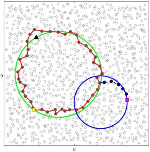
DCS-GHT exploits the primitive store for data storage and retrieve for data retrieval. The store primitive takes in input a datum d and its meta-datum k. By hashing k, it produces a pair of coordinates (x, y) and uses the GPSR routing protocol [94] (that has been described in Subsection 2.1.2) to select a set of sensors (called home perimeter ) forming a perimeter around (x, y). Then, to enforce data persistence against sensors’ faults, the sensors in the home perimeter store a copy of (k, d). The retrieve primitive hashes the input parameter k (the meta-datum) to obtain the coordinate (x, y), then, by means of GPSR, it sends a request for the data with meta-datum k to the point (x, y). When this request reaches the sensors in the perimeter around (x, y), they send back the data they store that correspond to k. See Figure 2.5 for an example of store and retrieve execution, where the data producer P stores into the WSN a datum regarding a meta-datum k, and the data consumer C asks the WSN for data regarding the same meta-datum k. Both P and C hash k to the same location (x, y), then they route their requests towards that location. In the case of P , the store primitive semantics involve its request by storing a copy of its datum on all the nodes in the home perimeter around (x, y).
Figure 2.5: P stores data, C retrieves them, using DCS-GHT
In the case of C, a retrieve response is generated as soon as the query reaches one of the nodes belonging to the perimeter around (x, y).
Although innovative, DCS-GHT presents a number of limitations when deployed on real WSNs. It assumes a uniform distribution of sensors and uniformly hashes meta-data on them. Moreover, if WSN produces a large amount of data associated to the same meta-datum, all such data will be stored by the DCS-GHT within the same home perimeter, thus overloading sensors on that perimeter. To avoid this problem DCS-GHT employs structured replication(SR), that is a technique that augments event names with a hierarchy depth d and uses a hierarchical decomposition of the key space. Let us consider a single meta-datum that is hashed into a location r, and let us call r the root location for the meta-datum, and d the hierarchy depth. Let us consider the sensing area as the 0-level cell, and given an i-level cell, let us
Figure 2.6: Example of Structured Replication with a 2-level decomposition
divide recursively it into 4 smaller cells, splitting each coordinate span in half. For each hierarchy depth, there 4d cells, and 4d
− 1 mirror images of r, replicating the position of r in its d-level cell into the other cells of d hierarchy level.
For example, Figure 2.6 shows a d = 2 decomposition, and the mirror images of the root point (3, 3) at every level. A node that detects an event, now stores the event at the mirror closest to its location, which is easily computable. Thus, SR reduces the storage cost at one node for one key with n detected events from O(√n) to O(√n/2d). DCS-GHT must route queries to all mirror nodes, to find all data
stored into the 4d mirrors of r.
SR is efficient in limiting the quantity of data stored around a single home node, but this is not sufficient by itself to ensure load balancing, in fact the storage load can become unbalanced even if there is not an unbalance in the meta-data.
Resilient Data Centric Storage (R-DCS)[76] is an extension of DCS-GHT that addresses the issue of having all data of the same type stored on the same set of nodes. It divides the sensing area into zones, and each sensor can either be a monitor node, a replica node, or a normal node, with respect to a given event type. A normal node generates events and forwards packets, but it does not store data pertaining the given event type. Each zone has one sensor that is on monitor mode for each
event type, and these sensor know the location of replica nodes and forward the event data the closest replica node. Replica nodes, finally, are monitor nodes that can store data regarding a given event type.
Bottom line, R-DCS adds to the efficiency of the DCS system limiting the data transmission from the sensor producing a datum to the monitor node of its zone, and then to the closest replica node. Moreover, resiliency to failures is improved since data are not replicated locally, but instead it is located on replica nodes that are far away from each other, and hence a disaster, that would destroy all sensors close to it, can not exterminate all replica nodes for a given meta-datum.
Another variant of DCS-GHT is Rendezvous Regions (RR)[77], that has mecha-nisms similar to DCS-GHT but, instead of directing queries towards an home node, it makes use of regions in the sensing area, and of all the sensors located into those regions. In RR the network topology is divided into geographical regions, where each region is responsible for a set of keys, with keys representing meta-data of sensed data, or services offered by sensors. The service or data provider stores informa-tion in the corresponding region, and the service or data user associates directly its query to the region. The obvious distinction between RR and DCS-GHT is using a rendezvous region instead of a rendezvous point. Moreover, RR is also targeted to designing geographic systems that need only approximate location information for the nodes.
Both DCS-GHT and RR are prone to problems related to the WSN topology: the number of sensors storing a datum depends on the number of sensors in a perimeter, or on the population of a region. Chapter 3 will present novel DCS techniques that let the user application control the number of sensors that store data, hence providing Quality of Service (QoS) for Data Centric Storage.
Cell Hash Routing
Another DCS Data Management layer based on distributed hash tables is Cell Hash Routing (CHR)[78], that is based on the notion of cells, which are a subdivision of the plane into areas of predefined and globally known shape. CHR groups nodes into clusters (that are sets of nodes) that are located into the same cell using a distributed protocol (e.g. dividing the sensor field into a mesh of squares), with the consequence that nodes are not individually addressable, because the relevant network entity is the cluster. Then CHR uses the clusters, instead of individual nodes, to both query the WSN and hold the values. In this architecture, produced data are not the readings of a single sensor, but instead is a value related to a whole cell, like the maximum temperature in the cell, or the mean humidity level.
A crucial aspect of the clustering is that there is a mapping between the iden-tification of a cluster and its physical location, to enable the use of a geographical routing scheme. Data are described by a meta-datum, that is hashed into geographic coordinates as in DCS-GHT[87], then data are routed to the cell that includes that location. As soon as the data reach the destination cell, they are stored in all the
nodes in the cell. If the cell is empty (e.g. it has no sensor) CHR uses an approach similar to DCS-GHT to replicate the data around the empty cell.
The advantages of this approach are the followings:
• clustering creates a structured and sparsely populated network of clusters, where a simple protocol is sufficient for routing
• the efficiency of the routing scheme is not affected by increasing node density, and the routing scheme also scales with increasing network sizes, because it is localized
• since cells are immutable, clusters can receive an identification that does not change over time, and nodes can always determine which clusters they are on, and which clusters their neighbors belong to, even in dynamic scenarios where nodes move from cell to cell, hence modifying their cluster identifier
The paper that proposed CHR [78] adopts a vision similar to the one in this thesis, proposing to organize a complex middleware into layers. The paper suggests that CHR can be used as a component to build, for example, a publish/subscribe system. Moreover, the routing protocol is described as a variant of GPSR that works on cells, and hence CHR approach can be considered as building over an existing GPSR-like Network layer.
Double Rulings
Another approach to information storage and retrieval is Double Rulings[119]. Dou-ble Rulings stores data not at a single node or its nearby neighbors, but at nodes that follow a one-dimensional curve, while a data request travels along a set of nodes that follow another one-dimensional curve. The curves are functions of both the lo-cations of the producer and the consumer, and of the types of data that are stored or retrieved. Successful retrieval is guaranteed if every retrieval curve intersects ev-ery data storage curve. For example, assume the network is a two-dimensional grid embedded in the plane with nodes located at all the lattice points, like in Figure 2.7. The information storage curves follow the horizontal lines. The information retrieval curves follow the vertical lines. Each vertical line intersects each horizontal line, thus an information consumer can always find the data produced by the producer. This double-ruling scheme is locality aware (if the producer and consumer are actually near each other, they must also be near each other along the path connecting them using the horizontal and vertical lines) and it has better fault tolerance by replicating data on nodes that are uncorrelated with node proximity.
With real WSNs, the previous scheme is not suitable, since the network has not such a regular topology. The paper about Double Rulings hence proposes stereo-graphic projection, a kind of projective geometry, to map nodes onto a sphere (see Figure 2.8), projecting points on a sphere one-to-one to points in the plane: a sphere
Figure 2.7: Double ruling on a grid .
Figure 2.8: Projective geometry, to map point between a sphere and the plane. .
with radius r is put tangent to the plane at the origin, and a generic point h∗ on
the plane is mapped to the intersection of the line through h∗
and the north pole with the sphere. Stereographic projection preserves circularity (circles on the sphere are mapped to circles in the plane) but it does not preserve distances or area. In particular, the distortion around the north pole can be high.
Figure 2.9: Producer on longitude curve, consumer on latitude curve. .
The double ruling scheme for points on a sphere is based on the fact that any two great circles of the sphere must be intersected. Another solution is to consider longitude curves for the data producer and latitude curves for the data consumer. The meta-datum is hashed to a point in the plane, that is where the stereographic sphere is placed. The curve that is selected for data storage is the longitude curve that crosses the sensor performing the storage operation, for data retrieval is the latitude curve that crossing the data consumer. See for example Figure 2.9, that features a sensor (yellow square) that stores a datum whose meta-datum is hashed to the black triangle. The datum is stored on the red colored sensors. The data
consumer (pink square) travels over the blue line, that is the stereographic projection of a latitude curve of the sphere placed on the black triangle.
K-D tree based DCS
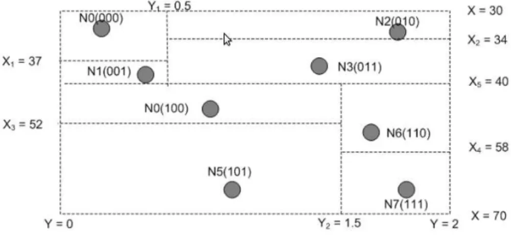
Distributed Index for Multi-dimensional data (DIM)[105] and K-D tree based Data Centric Storage (KDDCS)[121] are alternatives to DCS-GHT that do not need sen-sors to know their location in the sensing area.
In DIM, the WSN is organized using a K-D tree. The leaves of the tree partition the coverage area, and each element of the tree comprises one or zero sensors. The tree is built using a recursive distributed algorithm, the execution of which is divided into rounds. Each odd/even round each region of the partition that contains more than one sensor is bisected horizontally/vertically, and all the sensors that belong to the new regions have a bit appended to their address, specifying which half of the region the sensor resides on.
When a datum needs to be stored in the WSN, a long binary code is generated for the datum, and a path into the K-D tree is followed as far as possible, ending up on a leaf. Bits of the binary code are considered one by one, and each bit leads to a region split. When a bit leads to a region that does not exist, the datum is stored on the sensor residing on the last region that was considered.
DIM copes with node failures by replicating information stored at a node onto a nearby node, so that it can be reached easily in the search process, with the constraint that this other node resides in a different region than the first one. As a totally different alternative the back up region can be the one whose binary code is the complement of the code for the primary region. With this alternative two searches can be started in parallel or sequentially. Higher resilience to regional node failures is offset by higher cost for the parallel search or longer latency. This technique is easily generalized with a hash function that outputs several different (possibly far away) storage points for a given event that can be searched in parallel or sequentially.
KDDCS, on the other hand, does not split each region in half while building up the K-D tree. Instead, it uses a weighted median, such that the same number of sensors is on each split of the region. See for example Figure 2.10, that shows an example of execution of the K-D tree building algorithm for KDDCS.
DCS on virtual coordinates
Most DCS mechanisms are based on geographical Network layers that operate using the physical coordinates of the sensors. Since this approach has drawbacks (see for example [100]), some solutions based on virtual coordinates (see Section 2.1.3) were proposed. For instance, a system that is based on virtual coordinates was presented in[120]. This Data Management layer is a two-level Data Centric Storage scheme that integrates the distributed hash table idea and the double-ruling idea, using a