Non-Urbanised Areas in a metropolitan context.
A method for the characterization of agricultural and
green infrastructure.
Santi Daniele La Rosa
Università degli Studi di Catania
Dottorato in Analisi, Pianificazione e Gestione integrate del territorio - XXIV ciclo
Tutor: Prof. Francesco Martinico
Introduction - Urbanization process and peri-urban spaces in
contemporary metropolitan areas
1.
Non-Urbanised Areas: definition and role for ecosystem
services provision in metropolitan regions
1.1. A definition of Non-Urbanised Areas (NUAs) 1.2. Ecosystem services provided by NUAs 1.3. Overview of urban ecosystem services 1.4. The value of ecosystem services 1.5. Pressures on urban contexts
1.5.1. Urban sprawl 1.5.2. Climate Changes
1.6. Why a characterization of NUAs?
2.
Geographic technologies, Planning Support Systems and
urban planning
2.1. Rationality and role of information for land-use planning 2.2. Planning and GIS
2.3. Planning Support Systems 2.4. Use of PSS by urban planners
3.
Approaches for NUAs planning
3.1. Green infrastructure 3.2. Urban ecological networks
3.3. The agricultural and gree infrastructure
4.
The case study: Catania Metropolitan Area
4.1. Introduction to urban sprawl and its dynamics4.2. Municipalities of Mascalucia, Gravina di Catania and Tremestieri Etneo. 4.3. Land Uses
5.
Characterization of NUAs for urban planning: methodology
and results
5.1. The analytical phases for NUAs characterization 5.2. Land cover analysis
5.2.1. From Land Use to Land Cover
5.2.2. Geographical Sampling for Evapotranspiration assessment 5.2.3. Results
5.3. Fragmentation Analysis and 5.3.1. Indicators of fragmentation 5.3.2. Results
5.4. Proximity to residential uses 5.4.1. definition of proximity 5.4.2. results
5.6. Compatibility of proposed uses
5.7. An alternative method for Land Cover extraction: the R package RasClass 5.7.1. Background and methodology
5.7.2. Results
6.
Discussions on results, proposals and conclusions
Acknowledgements
Humanity
isincreasingly
urban
,but continues
to depend on
Nature
Introduction
Urbanization process and peri-urban spaces in contemporary metropolitan areas
Since decades, in many European countries, dynamics s of urban and economic growth are separated from the demographic development (Kasanko et al., 2006). But despite of the decreasing of population, urban expansion due to spatial development pressure has been an impressive driver of a very high consumption of land and agricultural resources. This has resulted in a overall decreasing of the provision of ecosystem services. In the period between 1990 and 2000, at least 2.8% of Europe´s land had experienced a change in use “including significant increase in urban areas” (Commission of the European Communities 2006).
The European Environment Agency (2006) has described the process of the urban sprawl “as the physical pattern of low-density expansion of large urban areas, under market conditions, mainly into the surrounding agricultural areas”. Sprawl is the leading edge of urban growth and implies little planning control of land allocation. Urban development is usually patchy, scattered and strung out, with a tendency for discontinuity. It leap-frogs over areas, leaving agricultural enclaves. Sprawling cities are the opposite of compact cities — full of empty spaces that indicate the inefficiencies in development and highlight the consequences of uncontrolled growth”. In the same document, EEA identified urban sprawl as the “ignored challenge” which urgently demands progressive actions towards sustainable urban development for all the EU-member states. It must be underlined that, although this issue is well known since decades, only recently it has been clearly focused and addressed at the European level, as shown by the important document of (EEA) in 2006.
Since the first years of the 70ies, the main Italian cities have started to experience a new model of spatial development that have deeply modified and altered the urban landscape. This process have been called in many different ways, all related to the metropolization of the landscape (Camagni et al., 2002) or the diffuse city (“la città diffusa”, Indovina, 1990). It is present in many Italian metropolitan areas, from the heavily urbanized Milan to the southern metropolitan areas of Catania and Palermo (fig. 0.1).
The process of urbanization have changed its pattern. A stronger polarization of services and workplaces toward the CBD of main cities can be observed, but, on the other way, new urbanizations occur on the second or third strip out of the city (Privitera, 2010). Urbanization processes are transferred to agricultural small municipalities close to the main centers, with pressures that these small municipalities are often not able to bear.
Urbanizations are not continuous and show low density patterns so that outside the main city the landscape is characterized by a strong degree of fragmentation of agricultural lands and mixes of urban and non-urban uses. An almost endless landscape of low density settlement has became the main landmark of new metropolitan areas. The relationship between the agricultural landscape and the city has produced a particular contemporary peri-urban landscape, where residential low-density settlement are mixed to farmland that have been partially modified and reduced by urbanizations.
Fig. 0.1 – Examples of urbanization in two different Italian contexts: the Milan metropolitan (Schetcke et al., 2010); Catania and Palermo metropolitan areas (Urban Atlas, 2010)
Today, this peri-urban space is the place where the new urbanizations continue to take place: new fragments of city feature detached or semi-detached houses with small gardens, shopping malls and manufacturing buildings . All these elements keep appearing in the peri-urban areas where agriculture uses can be present or abandoned.
More and more people are moving away from the center of metropolitan areas (apparently attracted by the quality of life in these rural settings) to live in residential developments built on converted peri-urban farmlands. “The detached terrace-houses and semidetached terrace-houses condense the new type of residential landscape in the metropolitan peripheries of the cities of southern Europe.” (Munoz, 2003). We have seen the born of a new “semi-detached” landscape, “composed, designed and structured as a discontinuous sequence of physical elements: the semi-detached houses themselves, the roundabouts for the distribution of domestic traffic, or the medium and large shopping malls.” (Munoz, 2003).
This process of metropolization shows also how settlements belonging to different municipalities, once far one from another, are becoming closer and parts of the same metropolitan area.
From a social perspective, the issues concerning the contemporary sprawled models and their impacts are very hard to be communicate to and understood by common people and citizens: for instance the model of detached house is still very idealized and desirable, in a general view that the peri-urban space is as more healthy and pleasant and “ natural” to live in than the urban one.
This research of “less urban settlement” or “escape from the city” produces a reverse and contrary effect on the daily behavior of the new city users (Martinotti, 2000) that are forced to spend longer period of their days for moving to/from the main city where workplaces are located. This way of living and moving along the entire metropolitan area is entirely based on the use of private cars, with the related increase of transportation times, costs and environmental externalities. These behaviors are particularly present in metropolitan areas of south Italy, where the development of an efficient public transportation network is still lacking.
In contemporary metropolitan areas the concept of rural-urban fringe, as appeared in the geography and planning literature in the 1930s (Whitehand, 1998) ,is today less and less able to distinguish what is urban from it is rural. A chaotic set of land uses is “a product of post-war planning legislation that has partly fossilised some patterns of use, but it is also a reflection of dynamic change as certain components of these areas have grown as part of complex and singular developments (Gant et al., 2011).
In new metropolitan contexts, rural land and its agro-ecological features are exposed to dramatic pressures that are driven by the expansion of the urban influence on areas that once were considered as purely rural (Donadieu, 2004).
Impacts on rural and natural areas
In this context, agricultural lands suffer from a wide range of pressures by urbanization process. These pressures are physical, environmental and socio-economical (EEA, 2006).
The environmental impacts of sprawl on natural areas are today well documented. Land sustains many ecosystems functions (i.e. production of food, habitat for species, recreation, water retention and storage) that are directly linked with existing land
uses. Impacts on natural areas are also exacerbated by the increased proximity and accessibility of urban activities to these areas, that in the past were more far from “urban influence”. This proximity produces stress on ecosystems and species through noise and air pollution. Moreover, the fragmentation caused by transport infrastructures and other urban-related activities creates significant barrier effects that can degrade the ecological functions of natural habitats. Fragmentation can heavily modify corridors spaces for species or can isolate populations by reducing habitats to extent below the minimum area required for the life of these species. Urban development and agriculture compete for the same land, as agricultural lands closer or adjacent to urban areas are ideal places for urban expansion. Farmer’s reasons in this process are clear as they can get substantial financial benefits for the sale of farmland for new housing or other urban developments, especially in times of a general crisis of agriculture. On the other way, agricultural soils need to be conserved, since they are almost non renewable resources. Urban sprawl reduces soils’ capacity to perform their essential functions. Among the main impacts of urban sprawl can be identified the following: soil sealing with a related loss of water permeability, loss of soil biodiversity, reductions of the capacity for the soil to act as a carbon sink are In addition, the rainwater falling on sealed areas presents high levels of pollutants (i.e. high concentrations of heavy metals), being an important threats for the conservation of which the hydrological system.
The loss of agricultural land has also major impacts on biodiversity, involving the risk of loosing some valuable biotopes for many species, particularly birds. According to EEA (2006), in Europe the urban expansion tends to “consume the best agricultural lands, displacing agricultural activity to both less productive areas (requiring higher inputs of water and fertilizers) and more remote upland locations (with increased risk of soil erosion). In addition, the quality of the agricultural land that is not urbanised but in the vicinity of sprawling cities has also been reduced”.
From a social point of view, sprawl generates can segregation of residential development according to the higher degree of income that are observable in some sprawled settlement, even if this aspect is today not so significant as it was in the past and it is present with less intensity in Italian metropolitan areas. The socio-economic types of suburban and peripheral areas is characterized by middle and upper income families with children, who have the necessity of a high mobility to let them doing all their daily activities.
From an economic perspective urban, sprawl is at the very least a more costly form of urban development due to:
• increased household spending on commuting from home to work over
longer distances;
• the cost of the congestion in sprawled areas by inefficient transportation systems;
• the additional costs of the building of new urban infrastructures and related
services, across the metropolitan area.
• The reduction of the value of agricultural value of soils with high proximity to
urban areas but a complementary increased and related increase of value of the land waiting to be developed
Urban sprawl inhibits the development of public transport and solutions based on the development of mass transportation systems, and the provision of alternative choices in transportation that are essential to ensure the efficient working of urban environments.
Numerous studies indicate the increased infrastructure cost associated with sprawl compared with infill or contiguous and compact development (Travisi et al., 2009). These issues may address attempts of control of urban sprawl, by promoting urban policies aimed at the use of public transport and reducing the private car use.
Aspects of economic inefficiency are also associated with the market oriented planning that frequently generates sprawled urban areas and has big responsibility in sprawl processes. This kind of market orientates land-use to urban expansion in new areas, without taking into account the potential re-use of former residential or industrial areas. Another important aspect of inefficiency is related to the general savings of energy (consumption of electricity, water, oil and efficiency in waste management), in more compact settlements compared with sprawled one.
What’s left?
The process of gradual erosion of peri-urban agricultural land has been accompanied by a low consideration of the important of these areas, often just view as a mere reservoir of space for new urban settlements. Particularly, the agricultural land has been represented in land-use plans during the 70ies and 80ies with different size white patches (“zone bianche”), which strongly characterized the maps of these plans. White as the colour of blank, of places to be filled in with a “built-up anything” or areas waiting for something.
During the last 50 years urbanizations, in Italy, peri-urban space has always been considered as an almost unlimited reservoir to be used for new settlement. No consideration about natural resource (soil, water, species, landscape) has been usually attributed to it. Different generations of urban plans have been used soil and agricultural lands as unlimited resources, without any constraint except their geographical extension. In the past, urban planning (strongly driven by real estate market) has not been able to assess agricultural areas in a sufficient way so to recognize the roles, functions and services they provide to human beings.
This indifferent towards agricultural peri-urban areas has been one of the reasons at the base of the contemporary sprawling of urbanization process. Since the land has no particular inner value, planners and city decision makers have been moved to use it as a place for new urbanizations without overall landscape project that was able to consider peculiarities and features of peri-urban and agricultural landscape.
The new pattern of dispersed, low density development spreads distributes a relevant number of residences (mainly detached and semi-detached houses), retail stores and industrial and office parks across a broad area. Co-existence of developed and agricultural uses in such a settlement pattern is more common than in the homogeneous suburban contexts. For this reason the open spaces between small developments can be utilized for new forms of agriculture (Heimlich and Barnard, 1992).
What’s left today of the peri-urban natural agricultural areas? A different mix in types and sizes of residual and Non-Urbanised areas characterize deeply metropolitan landscapes in many Italian regions.
Farmland, abandoned or still in use, small orchards, wood and shrubs areas, urban parks, regional parks, reserves and natural protected areas, grasslands (fig. 0.2).
Fig. 0.2 – Examples of Non-urbanised area of different type and size in the Catania Metropolitan area (from Google maps: last access November 2010)
Gallent and Shaw (2007) identified a number of land use in the transition zone from urban to rural of the Green belts in the UK: service functions, commercial activities; noisy and unsociable uses pushed away from people; transient uses such as markets; bulk-retail; light manufacturing; warehousing and distribution; some public institutions; degraded farmland; planned recreational areas such as country parks; fragmented residential development (often centred on road junctions) interspersed between; areas of unkempt rough or derelict land awaiting re-use.
Despite the very different geographical location, these pattern of land uses are very similar to the ones that can be found in Italian contexts.
These areas are characterize by various sizes: this is a common features of these metropolitan contexts, where the very different pattern of urban growth has produced a various range of size and extent of Non-Urbanised areas.
Another important common feature of these areas is the high proximity to urban land uses (residential, retails, manufacturing) and this have a lot of consequences from different side like the value of the land or its accessibility.
Despite the dramatic urbanization processes, these areas are still present in metropolitan context, still provides important and numerous ecosystem services (see section 1) and therefore need to be accurately analyzed and assessed, in order to develop new scenarios for the land-use of these areas. Moreover, understanding the contemporary Non-Urbanised areas is important for a correct and up to date analysis of the develop of metropolitan contexts and of the complex processes that have define these contexts.
The characterization of these areas with appropriate analytical tools is therefore a fundamental step for urban planning to identify their peculiarities and potentialities and to better choose the most appropriate land uses to maintain their integrity and provided ecosystem services.
1.
Non-Urbanised Areas: definition and role for ecosystem
services provision in metropolitan regions
1.1.
A definition for Non-Urbanised Areas in metropolitan contexts
With reference to metropolitan contexts, Non-Urbanised Areas (NUAs) are part of the urban and natural areas that produce ecosystem services. They are outdoor places with significant amounts of vegetation, mainly semi-natural areas that represent the last remnants of nature in urban areas (Jim and Chen, 2003). They preserve biodiversity in urban areas, sequester CO2 (McHale et al., 2007; Nowak and Crane, 2002), produce O2 (Jo, 2002), reduce air pollution (Yang et al., 2005) and noise (Fang and Ling, 2003), regulate microclimates, reduce the heat island effect (Shin and Lee, 2005), affect house prices (Kong and Nakagoshi, 2006), have recreational value (Tarrant and Cordell, 2002) and are useful for health, well-being and social safety (Groenewegen et al., 2006).Urban green space are often referred as network which include physically and/or functionally interconnected formally designated green spaces as well as informal natural areas irrespective of their size, composition or use (Tzoulas and James, 2010). In literature, NUAs have been classified in different ways, resulting in a varied range of definitions.
The FEDENATUR Report to the EU – DG environment have focussed on periurban spaces of nature, classifying them in three categories (European Commision, 2004). Peri-urban free spaces are non-urbanised spaces located within the area of urban influence; they are covered by agricultural or natural land, sometimes damaged but which can be restored. These spaces can be speckled with localised built-up areas. Peri-urban natural spaces (PNS) are non-urbanised spaces within the area of urban influence, mainly occupied by spontaneous vegetation or other natural environments (water, rock), sometimes in combination with agricultural land. Urbanised land, if it exists, only occupies a small part of the land. Peri-urban natural parks are spaces protected from urbanisation, and dedicated to the preservation of the biodiversity and receiving public, in particular with an educational objective. They are managed by a non-profit making organisation or other public bodies which are in charge of the conservation and management. The land may be held by private owners, public organisms (local collective, state…) or other associations.
Periurban (natural) spaces, free spaces from urbanization, urban parks are therefore different meanings of areas that in urban or periurban contexts are still not urbanized or maintain their nature (park) or semi-natural (farmaland) status.
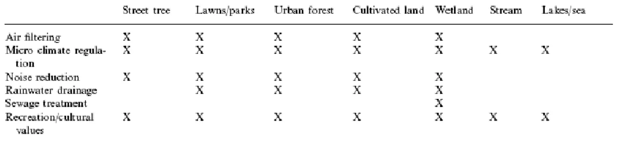
According to our definition NUAs can comprehend different urban ecosystems, depending on geographical regions. The term “urban ecosystems” can be used to identify all natural green and blue areas in the city (Bolund and Hunhammar, 1999). Different types of urban ecosystems which can be call “natural”, even if almost all areas in cities are transformed and managed by men. Examples include street trees, lawns/parks, urban forests, cultivated land, wetlands, lakes/sea, and streams (Bolund and Hunhammar, 1999).
Street trees are stand-alone trees, often surrounded by paved ground. Lawns and parks are managed green areas with a mixture of grass, larger trees, and other plants. Areas such as playgrounds and golf courses are also included in this group. Urban
forests are less managed areas with a more dense tree stand than parks. Cultivated land and gardens are used for growing various food items. Wetlands consist of various types of marshes and swamps. Lakes/sea includes the open water areas while streams refers to flowing water. Other areas within the city, such as dumps and abandoned backyards, may also contain significant populations of plants and animals. It should be possible, however, to place most urban ecosystems or elements in one of the above mentioned categories.
In urban planning, classifications and used typologies of NUAs must be site specific, as well as orientated to the aims of the classification itself. In this research, we will deal with an urban context of the Catania metropolitan area (see section 4), characterized by a considerable presence of urban settlement at different density (from historical centers to sprawled low density settlements). The following category/typologies of NUAs can be found in the study area of the Catania Metropolitan area (see section 4), as mapped by land-use (see section 5).
Agricultural areas
Agriculture in metropolitan areas c contrasts sharply with its non-metro counterpart. As observed by Heimlich (1989), “the longer areas are affected by urban pressures, the greater the adaptation they reflect in some farm characteristics”.
Agricultural areas can be part of NUAs. and they can be urban or peri-urban, in use or abandoned (fig. 1.1). Fragmentation and extreme variety of size are among the main features of agricultural areas in italian metropolitan areas.
Fig. 1.1 – Example of cultivated Vineyards (left) and abandoned agricultural terrace (right) in the Catania Metropolitan Area (pics by Riccardo Privitera)
The “metropolitan nature” of these areas underpins their importance and sometimes not enough investigated functions and services provided by agricultural areas in urban contexts (Swinton et al., 2007). Agriculture both provides and receives ES that extend beyond the provision of food, fiber, and fuel, sot that only in their absence they do most become apparent. Among managed ecosystems, farmland offers special potential because of it variety of generate ecosystems services That potential arises from both its broad spatial extent and human management objectives focused on biotic productivity (Swinton et al., 2007). At the same time, agriculture offers potential to diminish its reliance on external agrochemical inputs by reliance on enhanced management of supporting ecosystem services
Moreover, we consider also green spaces which are not necessary connected in a network and that can be sprawled and dispersed inside and around the urban system.
Fig. 1.2 - Ecosystem services to and from agriculture (Swinton et al., 2007)
Woods
In Catania metropolitan area woods are generally highly fragmented patches among sprawled urban settlements and the mosaic of agricultural areas (Dazzi, 2007). They represent the last remnants of wider natural systems, once present in the area of Mt. Etna, typically represented by oaks woods (Quercus virgiliana, Quercus dalechampii, Quercus congesta) (fig. 1.3).
Fig. 1.3 – Trees and fruit of the Quercus Virgiliana (source: Dipartimento di Botanica dell’Univerisità di Catania: http://www.dipbot.unict.it/ctnatura/flora/bo_celt.html, last access: 29/11/2011)
Shrubs and Re-colonized lava fields
Shrubs (fig. 1.4) are typical types of vegetation of the base belt of Mt. Etna anc can be found under volcanic soil from recent eruptions.
This thermophile vegetation (“macchia”) has a high density and it is characterized by specie like Euphorbia dendroides (also typical of marine areas). This vegetation also tends to colonizes lava fields (fig. 1.5) or abandoned farmlands and it is usually replaced by steppes of Hyparrhenia hirta, Asphodelus microcarpus, Ferula communis and Thapsia garganica (Messina and Pavone, no date)
Fig. 1.4 – Example of shrubs in Catania Metropolitan Area (pic by Riccardo Privitera)
Fig. 1.5 – Example of colozination of shrubs on lava fields in Catania Metropolitan Area (pic by Riccardo Privitera)
1.2.
Ecosystem services provided by NUAs
As previously introduced, NUAs provide different kind of ecosystem services (ES). These services were firstly defined by a work by Costanza et al. (1997) as ‘‘the benefits human populations derive, directly or indirectly, from ecosystem functions’’. In this important work, authors have identified 17 major categories of ecosystem services (fig. 1.6). A number of these ecological services are not consumed by humans directly, but are needed to sustain the ecosystems themselves. Such indirect services
include pollination of plants and nutrient cycling, but the classification is not obvious. Another aspect of ES is that they have different spatial cover and extent: services can be available on the local or global scale according to the issue at hand and to the possibility of transferring them from where it is produced to the city where humans benefit from it. Such a transfer can take place both by man-made transport and by natural means (e.g. atmospheric transport). Easily transferred services with a global scope, like CO2 sequestering, do not necessarily have to be produced close to the source of the problem. Services which are impossible to transfer must, however, be generated close to where they are consumed (e.g. noise reduction).
There is a main different from an ecosystem service and ecosystem function, as defined by Escobedo et al. (2011), related to the fact that ES are always related to humans. It is this attribute that distinguishes them from ecosystem functions. Ecosystem functions occur independently from the humans who may benefit from them (Tallis and Polasky, 2009). For example, if a tree intercepts polluted air or water, it performs an ecosystem function; if that function improves local air and water quality then the air and water quality improvement is the ES that benefits human’s health. Escobedo et al. (2011) reviewed some definition of ES that are based on this different between ecosystem function and services. “Brown et al. (2007) define ecosystem services as “the specific results of ecosystem functions that either directly sustain or enhance human life.” Similarly, Fisher et al. (2009) define ecosystem services as aspects of ecosystems utilized actively or passively, directly or indirectly to produce human well-being. Boyd and Banzhaf (2007) and Kroeger and Casey (2007) narrow the definition further by arguing that only components of nature that are directly enjoyed, consumed or used to produce human wellbeing should be counted as final ecosystem services” (Escobedo, 2011).
Fig. 1.6 - Ecosystem services as defined by Costanza et al. (1997)
1.3.
Overview of urban ecosystem services
Humanity is rapidly urbanizing, and it has been evaluated that by 2030 more than 60% of the world population is expected to live in cities (UN, 1997). But even if humanity is increasingly urban, we are still as dependent on Nature as before.
When humanity is considered a part of nature, cities themselves can be regarded as a global network of ecosystems. If compared with true, natural ecosystems, the man-made ones are however immature due to features like their rapid growth and inefficient use of resources such as energy and water (Haughton and Hunter, 1994). Odum (1971) even observes that cities are the ‘‘only parasites in the biosphere’’. But there is also a presence of natural ecosystems within the city limits. The natural urban ecosystems contribute to public health and increase the quality of life of urban citizens, e.g. improve air quality and reduce noise. Most of the problems present in urban areas are locally generated, such as those due to traffic. Often the most effective, and in some cases the only, way to deal with these local problems is through local solutions. In this respect, the urban ecosystems are vital. Other issues
are generated more globally, but they heavily influence urban environment: risk related climate changes are the most evident of these issues.
In urban areas, Bolund and Hunhammar,(1999) summarized some of the generated services can be highlighted from the set listed by Costanza et al. (1997) (fig. 1.6) air filtering (gas regulation), micro-climate regulation, noise reduction (disturbance regulation), rainwater drainage (water regulation), sewage treatment (waste treatment), and recreational/cultural values. Other services, such as food production and erosion control usually have a less importance in urban areas (fig. 1.7).
Fig. 1.7 -Ecosystem services in urban areas (Bolund and Hunhammar, 1999)
Accordingly this taxonomy, it can be highlighted as the different ecosystems are able to provide many services. A brief overview follows.
Air cleaning and pollution reduction
Air pollution caused by transportation and heating of buildings, among other things, is a major environmental and public health problem in cities. Urban vegetation plays an important role in the environment of cities reducing atmospheric levels of greenhouse gases and PM10 (McHale et al., 2007, [Nowak and Crane, 2002] and [Yang et al., 2005] ).
The reduction is primarily caused by vegetation filtering pollution and particulates from the air. Filtering capacity increases with more leaf area, and is thus higher for trees than bushes or grassland (Givoni, 1991). Due to the larger total surface area of needles, coniferous trees have a larger filtering capacity than trees with deciduous leaves However, coniferous trees are sensitive to air pollution and deciduous trees are better at absorbing gases. A mix of species therefore seems to be the best alternative. In general, vegetation is much better than water or open spaces for filtering the air.
In particular, urban forests can directly affect air quality in two different ways: 1) by increasing dry deposition and thus removing air pollution from the atmosphere, and 2) by increasing biogenic volatile organic compound (BVOCs) emissions that can act as precursors of secondary air pollutants, though both direct and indirect effects can occur (Escobedo and Nowak, 2011). Even if It is clear that vegetation reduces air pollution, less clear is at what level this can occur, since local situation may produce different results in term of local decrease of pollutants.
On the contrary, some disservices characterized urban trees and plants, such as the emission of Volatile Organic Compounds, that can contribute to O3 and particulate matter formation, counteracting the potential beneficial effect of trees in improving air quality in urban areas. Furthermore, urban forests might be responsible of other negative effects including allergenic production (pollen), increased water use and general costs of maintenance (Alonso et al., 2011).
Results from McHale et al. (2007) have demonstrated that there are several key decisions that can influence the management of urban trees and forest. It is important to consider that there are other ecosystem services associated with urban trees, and, for this reason, one may be willing to spend more per credit than for other projects dedicated to only reducing atmospheric CO2 concentrations.
Climate regulation
Increased air temperatures can be expected to be particularly problematic in urban areas, where temperatures already tend to be a few degrees warmer than the surrounding countryside. This difference in temperature between urban and rural areas has been called the ‘urban heat island effect’ and it depends on the thermal conductivity and specific heat capacities of materials used in urban areas, surface albedo, the geometry of urban canyons and the input of anthropogenic heat.
Urban greening could affect temperatures through different processes (Givoni, 1991; Bowler et al., 2010). A key process is evapotranspiration, which describes the loss of water from a plant as a vapour into the atmosphere. Evapotranspiration consumes energy from solar radiation and increases latent rather than sensible heat, cooling the leaf and the temperature of the air surrounding the leaf. This contrasts with the effect of impervious urban materials such as asphalt and concrete, which do not retain water for evaporation and quickly absorb and retain heat when exposed to solar radiation. In addition to cooling by evapotranspiration, shading from trees can act to cool the atmosphere by simply intercepting solar radiation and preventing the warming of the land surface and air (Oke, 1989). This shading effect may create local cool areas beneath tree canopies and this can be an important issue in the management of urban open spaces. Finally, vegetation may affect air movements and heat exchange. This effect, however, can be expected to be dependent on the type of vegetation. Tree cover may retain warm air beneath the canopy; in contrast, an open grass field that provides low resistance to air flow may promote cooling by convection.
A recent overview by Bowler et al. (2010) (fig. 1.8) on different studies about urban greening showed that, on average, an urban park would have around 1 ◦C less than a non-green site. However, this evidence is mostly based on observational data of existing green spaces. Therefore, this hypothesis should continue to be tested through the appropriate monitoring of urban green areas, even if this activity may be often not financial sustainable by local authorities.
Monitoring should include collection of temperature data before and after implementation along with comparable ‘control’ non-green sites. Studies that measured temperature from multiple parks in the same urban area presented data showing that larger parks were cooler. Local climate may also affect the temperature of green space but most studies only collected data from a single urban area.
The extension of the cooling effect of a green area beyond its boundary is supported by data from a few studies. The scale of any cooling effect beyond the boundary of the green area is particularly important for the likely public health consequences of greening, as green space may not be directly accessible to all who might benefit during very high temperatures. A key line of future research should explicitly investigate the distance and size-dependence of the effects of green areas.
Different types of vegetation have shown to have different effects in cooling, particularly depending on the difference between short vegetation, such as shrubs or grass, and more dense tree canopy cover. However, further research should be
address to understand how the benefits of green space change with the particular context, such as local urban environment, geographical features, climate and type of greening involved.
Water features do also contribute to climate regulation: micro-climate can be regulated to a great extent by the large bodies of water present in cities.
Fig 1.8 – Result from the studies about urban green effect as reviewed by Bowler et al (2011).
Surface water run-off control
The influence of land use on storm runoff generation is very complicated, as land use and soil cover have an effect on interception, surface retention, evapotranspiration, and resistance to overland flow. The major effects of urban land uses on surface runoff are caused by the replacement of green features such as forest and grassland by more impermeable features like buildings, paved surfaces and roads. These changes dramatically alter the precipitation runoff after rain and storms.
Interception of rain before it reaches the soil surface is reduced because there is less vegetation to be wetted.
Moreover, infiltration of rain into the soil is also reduced because there is less permeable area.
A higher proportion of rainfall becomes surface-water run-off which results in increased peak flood discharges and degraded water quality through the pick-up of e.g. urban street pollutants (Haughton and Hunter, 1994).
This has serious effects since it increases peak river flows, and hence, the likelihood of flooding and bank erosion and water quality.
Green areas play an essential role to solving this problem in several ways. The permeable soils under vegetated areas allow water to seep through, while some rainwater is intercepted by leaves and it is then released it into the air through evapotranspiration. Even if the built environment seals the ground from rainwater, it has been suggested that urbanization also creates some new, unintended pathways for recharge . These include leaking water mains, sewers, septic tanks, and soakways. In vegetated areas only 5–15% of the rainwater runs off the ground, with the rest evaporating or infiltrating the ground (Bolund and Hunhammar, 1999). In cities without vegetation about 60% of the rain water is instead led off through storm water drains (Bernatzky, 1983). This will of course affect both the local climate and the groundwater levels. Valuation of this service depends on the local situation and it is related to settlement density and configuration. Cities with a high risk of flooding will benefit more from green areas, while, on the contrary, areas with a high percentage of impervious land covers yield more storm runoff than areas with more grassland or woodland.
Fig. 1.10 – The mechanism of storing nutrients by trees (soure: Benedict and McMahone., 2006)
Biodiversity
Natural and semi-natural ecosystems provide the living space for all species on earth. Since it is these species, and their role in the local and global ecosystem that provide most of the ecosystem services here described, the maintenance of healthy habitats is a necessary pre-condition for the provision of all ecosystem goods and services, directly or indirectly. The habitat function, can be split in two distinct sub-functions, as the refugium function (the provision of living space) and nursery function (the provision of breeding and nursery areas to species
which, as adults, are harvested elsewhere for either subsistence or commercial purposes) (De Groot et al., 2002)
Understanding, assessing, and enhancing biodiversity in urban areas is important, from conservation and social perspectives, since the question of whether, and to what extent, species of animals and plants can survive in urban settings becomes increasingly vital. Moreover, the conservation and enhancing of urban biodiversity have implications for human well-being, public health, and for making citizens aware of the importance of biodiversity conservation as the majority of people globally will experience “nature” and related ecosystem services primarily within the urban Fabric (Kowarik, 2011).
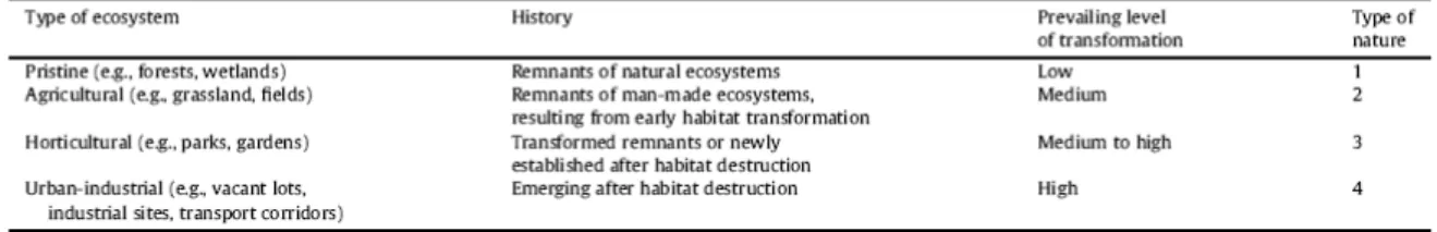
Cities as a whole can easily be seen as novel systems contrasting with rural surroundings, but scaling down to the habitat level shows significant differences . Kowarik (2011) illustrates major types of ecosystems that be found in urban areas, reflecting different human-mediated transformation stages, triggered by urbanization. Ecosystems “range from pristine remnants to agriculturally and horticulturally shaped systems to distinctive urban-industrial ecosystems that emerge on severely changed sites, mostly after habitat destruction” (Kowarik, 2011). In terms of novelty, emerging ecosystems on previously built-up areas or heavily changed urban land are novel, as are some horticultural systems that have been established, e.g., on landfills with artificial substrates or as green roofs on the top of buildings (fig. 1.11). Both novel urban ecosystems and remnants of pristine or
agricultural systems are influenced by urbanization, either directly by land-use or indirectly by effects resulting from the urban surroundings.
According to Kowaric (2011),strategies for biodiversity conservation in urban areas should be aimed at preserving (semi-)natural remnants and enhancing native species in urban regions with approaches that acknowledge and not refuses the contribution of novel urban ecosystems and associated species assemblages. These may be valued as adaptation strategies to severe habitat transformation and may secure the provision of ecosystem services in urban settings in an era of global change.
Fig. 1.11 – Types of ecosystem in urban areas as defined by Kowaric (2011)
Recreation and cultural values: (Tarrant and Cordell, 2002, Groenewegen et al., 2006). These kind of services are also called Information functions (de Groot et al., 2002). The recreational aspects of all urban ecosystems, with possibilities to play and rest, are high valued ES in cities. An interesting anthropological reason comes from Gallagher (1995). He argues that this is because, the longest period of human evolution took place within the context of undomesticated habitat, the workings of the human brain for gathering information and a sense of well-being are very strongly tied to the experience of natural landscapes and species diversity
Urban ecosystems (particurarly and urban greenspace) provide aesthetic and cultural values to the entire city. Bolund and Hunhammar (1999) reviewed different studies regarding the recreational an cultural value of urban ecosystem.
These type of services represent non material benefits that can be obtained from ecosystems through spiritual enrichment, cognitive development, reflection, recreation, and aesthetic experiences. They include:
• Cultural diversity. The diversity of ecosystems is one factor influencing the
diversity of cultures.
• Spiritual and religious values. Many religions attach spiritual and religious values to ecosystems or their components.
• Knowledge systems (traditional and formal). Ecosystems influence the types of knowledge systems developed by different cultures.
• Educational values. Ecosystems and their components and processes provide
the basis for both formal and informal education.
• Inspiration. Ecosystems provide a rich source of inspiration for art, folklore,
national symbols, architecture, and advertising.
• Aesthetic values. Many people find beauty or aesthetic value in various aspects of ecosystems, as reflected in the support for parks, viewshed, and the selection of housing locations.
• Social relations. Ecosystems influence the types of social relations that are
respects in their social relations from nomadic herding or agricultural societies.
• Sense of place. Many people value the "sense of place" that is associated with recognized features of their environment.
• Cultural heritage values. Many societies place high value on the maintenance
of either historically important landscapes ("cultural landscapes") or culturally significant species.
• Recreation and ecotourism. People often choose where to spend their leisure
time based in part on the characteristics of the natural or cultivated landscapes in a particular area.
Fig. 1.12 –Green spaces and playgrounds in urban areas (pics: Daniele La Rosa)
Soil retention and formation
The soil retention function mainly depends on structural aspects such as vegetation cover and roots. Tree roots stabilize the soil and foliage intercepts rainfall thus preventing compaction and erosion of bare soil. Plants growing along shorelines and (submerged) vegetation in near-coastal areas contribute greatly to controlling erosion and facilitating sedimentation. The services provided by this function are very important to maintain agricultural productivity and prevent damage due to soil erosion (both from land slides and dust bowls).
Soil is formed through the disintegration and degradation of rocks and gradually becomes fertile through the accretion of animal and plant organic matter and the release of minerals. Soil-formation is a very slow process (Rasio, 1999) and natural soils are generated at a rate of only a few centimeters per century and after erosion. Ecosystem services derived from soil formation relate to the maintenance of crop productivity on farmlands and the integrity and functioning of natural ecosystems.
Fig. 1.13 – Different type of soils (pics by Daniele La Rosa)
1.4.
The value of ecosystem services
The importance (or value) of ES can be expressed in different ways. Basically, there are three value domains: ecological, socio-cultural and economic (Millennium Ecosystem Assessment, 2003, De Groot et al., 2010). The ecological value is related to the health of a system and it ca be assessed with ecological indicators such as diversity and integrity. Socio-cultural value includes the importance people give to, for example, the cultural identity and the degree to which that is related to ecosystem services. Economic value can be split in two broad kinds of values: use values and non-use value. Use values encompass the direct consumptive use values such as the value of timber, fish or other resources provided by ecosystems, and direct, non-consumptive use values such as recreation and aesthetic aspects. Indirect use values relate to the services provided by nature such as air- and water-purification, erosion prevention and pollination of crops. Non-use value is the importance attributed to an aspect of the environment in addition to, or irrespective of, its use values. In essence, it can be understood as the value attributed to the simple existence of the ‘‘object’’ (i.e. its existence value), not considering the use that it can be done with that “object”.
There is also a type of value which is in between use and non use, the option value: the value we place on keeping the option open to use ecosystem services in the future, either within our own life time, or for future generations (in the latter case this is called bequest value) (De Groot et al., 2010). The sum total of use and non-use values associated with a resource or an ecosystem is called Total Economic Value (TEV). If we are interested in economic values only, the measurement unit will usually be money whereby it is important to realize that economic and monetary valuation will always capture only part of the total value (which should also include ecological and socio-cultural values) of an ecosystem or service. De groot et al. (2010) provided an overview of the many analytical and participatory techniques available to assess the value of ES. A number of ways exist to translate economic and some socio cultural values of ecosystem services into monetary values. Market prices (marginal values) can be used for many ES, especially the ones provisioning goods such as timber. Indirect market prices can be used to evaluate other services:, i.e. the (avoided) damage cost methods (for regulating services), and hedonic pricing and travel cost methods for some cultural services such as aesthetically pleasing landscapes (de Groot et al., 2010). Contingent valuation (i.e. measuring preferences
based on questionnaires) and benefit transfer (i.e. using data from comparable studies) provide yet other alternatives for evaluation ES. Existing methods have their advantages and disadvantages: although the knowledge base on the monetary value of individual services keep improving, there are still large data gaps and there is still a need for better frameworks, models and data-bases to calculate the TEV of ES.
1.5.
Pressures on urban contexts
1.5.1.
Urban Sprawl
There is a wide consensus on the idea that sprawl in western countries is heavily affecting the landscape. In Italy, this phenomenon is inexorably wearing down a unique heritage, the result of a long-lasting process of transforming the environment (Settis, 2011). In Italian contexts, sprawl has two main causes. The first is related to the spreading of single-family detached homes, which has become the winning settlement model in many western countries (Bourne, 1996, Peiser, 2001). The result is a continuous loss of agricultural land around the dense network of historical towns that are typical of northern and central regions of Italy (Dematteis, 1997). The second cause is strictly intertwined with the production system of industrial districts (Piccinato, 1993), which is a development model that was particularly efficient for strengthening the country’s competitive edge in the 1990s. At the same time, this model is posing considerable pressure on the environment and landscape, which has been sacrificed due to competitiveness and productivity. Traditional farming settlements have been converted to an endless landscape of small factories mixed with residential subdivisions. The prevailing reason in the examined area is that the diffusion of single-family homes is intertwined with farming. These areas, which can be defined as urbanized countryside, are characterized by many houses, farms and agricultural buildings (Martinico and La Rosa, 2009).
The externalities and impacts of sprawl growth patterns on the environment and landscape have been the focus in several studies. The impacts include the following: the loss of fragile environmental lands, increases in air pollution and energy consumption, decreases in the aesthetic appeal of the landscape, the loss or fragmentation of farmland, a reduction in biodiversity, increases in water runoff and risks of flooding, and ecosystem fragmentation (Galster et al., 2001; Johnson, 2001). Loss of agricultural land is often directly connected to land consumption due to sprawl processes (Olson and Lyson, 1999; Thompson and Stalker Prokopy, 2009). There are several consequences to this: landscape fragmentation and simplification, loss of biodiversity, decreasing the agriculture land value, and increasing the externalities of urban sprawl (Johnson, 2001; Camagni, 2002). New urbanizations often occur in proximity to already urbanized areas or existing infrastructure because the price of agricultural land is lower if compared to residential zoned land. Agricultural land usually becomes a highly attractive target for investors and urban developers (EEA, 2006). For these reasons, the hazard of loss of agricultural land may be potentially higher in areas close to already urbanized lands or roads.
1.5.2.
Climate changes
Climate changes have been predicted to have many consequences for human health arising from the direct and indirect impacts of changes in temperature and
precipitation (McMichael et al., 2003; Patz et al., 2005). One of the primary public health concerns is an increase in the intensity and frequency of heat waves, which have been linked with heat stroke, hyperthermia and increased mortality rates (Tan et al., 2007). For instance, an estimated 15% excess deaths were attributed to dramatic heat waves in Italy in the summer of 2003 (Istituto Superiore di Sanità, no date).
Different works show how extreme temperatures area expected more frequently. Annual maximum temperatures will increase more in the centre and south parts of Europe than in the north. A summer increase of temperature will expose Europeans to termic stress with no precedents and this will produce more damages in urban areas. In the Mediterranean area dry period are expected to heavily increase by the end of the century. According to Good et al. (2006) the longest dry period will increase of the 50%, especially in France and Central Europe.
These consequences appear to be more dramatic in urban areas, that will be especially vulnerable to the negative aspects of climate change (such as more frequent and severe floods, heat waves, etc.), due to the higher concentration of people and human activities. Urban environments can also be characterized by the combined effects of reduced evapotranspiration (because of less vegetation cover) and the thermal effect off the mass of buildings, which contribute to the heat island effect (Whitford et al., 2001).
Urbanization processes lead to changes in the absorption and reflection of solar radiation, and thus the surface energy balance. These changes are dependent from different factors, including the thermal conductivity and specific heat capacities of materials used in urban areas, surface albedo, the shape of urban canyons and the production of heat from human activities (Oke, 1989). Increasing temperatures resulting from global climate change may exacerbate the health impacts of the higher temperatures that are already common in urban areas (Luber and McGeehin, 2008).
Thus, there is a pressing need to evaluate strategies that may mitigate against further increases in temperatures in urban areas and the associated negative impacts on human health. An adaptation strategy that has been proposed is to ‘green’ urban areas, essentially by increasing the abundance and cover of vegetation (Givoni, 1991; Gill et al., 2007). Vegetation and urban materials differ in moisture, aerodynamic and thermal properties, and so urban greening could affect temperatures through different processes (Oke, 1989; Givoni, 1991). As previously discussed (see section 1.3) key process is evapotranspiration, which describes the loss of water from a plant as a vapor into the atmosphere.
This requires the development of appropriate urban adaptation strategies to mitigate negative impacts of climate changes. As a complement to such adaptation measures, there is a need to ensure that future land-use developments do not worsen the current level of risk, either through influencing the hazards themselves or through affecting the future vulnerability and adaptive capacity of the urban system. Urban planning therefore has a critical role to play, for mitigating the severity of hazards and for reducing the levels of exposure and vulnerability experienced by the urban system. Different scales of planning from macro scale land-use planning to micro scale urban design are both important to this process, responding to the different scales over which risk and vulnerability are expressed (O’Brien et al., 2004). This recognizes that although many aspects of adaptive behavior associated with vulnerability are the result of a decision-making process that operates at an
individual level, the government and other policy makers can address this process through their activities. Given the length of time involved in the strategic planning process, and the long lifetime of urban infrastructure, it is even more critical that decision-making does not reinforce negative feedback in any part of the process (Lyndsey et al., 2006). The urgency for information to assist with ‘‘climate conscious’’ planning is evident and ask for detailed tools for the assessment of different urban features that are involved in climate change processes.
1.6.
Why a characterization of NUAs?
Concurrent to their role as centers of disturbance, cities are also now home to the majority of humans. This demographic trend in urbanization is more strong in developing countries, but it expects to continue resulting in over 5 billion humans residing in metropolitan centers by the year 2030 (UN, 1997, 2007). As a result, cities have and will increasingly play a key role the delivery of public services as well as offer a critical arena in which to address a wide range of ecosystem health issues. The management of the systems providing ecosystem services becomes important both for the continued delivery of public goods and improving the ecological health of urban areas (Young, 2010).
As urban areas are expected to keep growing in the future, planners and political decision makers have to carefully consider the role of NUAs that provide ecosystem services. A better knowledge of the different features of NUAs allows us to identify the more suitable land uses to fulfill the aims of conservation and leisure as well as the promotion of new forms of agriculture (La Greca et al., 2011). Land use planning may allow the protection of green areas that have evapotranspiring and permeable features. This action is directly related to adaptation to climate changes, because it can reduce the urban heat island effect (Bowler et al., 2010) and excessive rainwater runoff. NUAs are also fundamental to increasing urban quality by creating more pedestrian friendly and visually pleasant settlements.
Scenarios for land-use should be carefully planned because of the environmental, social, economic and cultural benefits that are derived from the ecosystem services provided by agriculture and green infrastructure.
The characterization of NUAs with appropriate analytical tools is therefore a fundamental step to identify their peculiarities and potentialities and to better choose the most appropriate land uses to maintain their integrity and provided ecosystem services. Different models and methodology can be applied in order to help the planning process to better address a new scenario of land uses for these areas.
2.
Geographic technologies, Planning Support Systems and
urban planning
2.1.
Rationality and role of information for land-use planning
Urban planning concerns the design and organization of urban physical and socioeconomic space and measures that can be undertaken to solve problems in the use of the land. The general objective is usually to provide decisions about the land-use of activities or urban space which should be better than the existing pattern without planning (Hall 1975). This aim is usually achieved by using knowledge and creativity to design, evaluate and implement a set of justified actions in the public domain (Friedman, 1987). The knowledge may consist of scientific and experiential knowledge, implicit and explicit knowledge, technical knowledge and social knowledge, possessed by a number of societal actors.
Geo-information technology developers have long focused on supporting urban planners in handling knowledge and managing considerable amount of information. however There is not a general consensus about the how spatial models and technologies (i.e GIS) for supporting planning and decision making processes. This is partly related to the fact that most planning theories are based on different assumptions regarding rationality. Two types of rationality are of particular relevance for understanding the role of information technology in planning: instrumental (or functional) rationality and communicative (or procedural) rationality (Malczewski, 2004).
Instrumental rationality is based on a positivist idea, which puts spatial reasoning (Berry, 1993) and scientific analysis at the core of planning. It assumes a direct relationship between the information available and quality of planning and decision making based on the available information. On the other hand, communicative rationality postulates an open and inclusive planning process, public participation, dialogue, consensus building, and conflict resolution (Innes, 1995).
Even if the two perspectives are often viewed as antinomic, the role of information is relevant to both of them. It is rather the way in which the data are processed to obtain information and how this information is used and communicated that make the two perspectives different.
The ‘contrast’ between the technological and the political perspectives on the societal implications of geographic technologies is evident in a debate between the techno-positivist (proponents) of GIS and the social scientists (opponents) (Pickles, 1995).
Land-use planning is more than a technical procedure, because it also involves participatory approaches. Planners have to deal with different stakeholders, power relationships, and complex urban and regional problems, but they always need considerable amount of spatial information for their activities. This has some important socio-political perspectives on the use of new techniques (i.e. GIS) as tools for planning.
2.2.
Planning and GIS
Generally speaking, GIS-based land-use planning should be viewed as a process of converting data to information that adds extra values to the original data. At the
subsequent stage of the process, this derived information should be useful to those involved in the planning process. The particular planning needs determine nature and features of the information required.
Any planning process must focus on a mix of hard and soft information. Soft data/information is often derived from a public discourse between interest groups and individuals, while hard information comes directly from more codified sources in recognizable formats (cartography, tabular information. …). Central to the land-use planning is the way in which these two types of information are combined and how to define the right balance between the amount of hard and soft information used. The use of soft information may lead to subjective decisions, while, on the other hand, using too much hard information may result in high costs of the analysis phases and in troubles when try to communicate the obtained results. It appears clear that this balance produces a trade-off, that needs to be evaluated on case-by-case basis.
GIS have the capabilities of incorporating the soft data in order to be useful in answering questions related to the land-use planning.
One can suggest that information systems for planning in general and land-use suitability analysis in particular should be constructed with at least two interrelated perspectives in mind: (i) the techno-positivist perspectives on GIS, and (ii) the sociopolitical, participatory GIS perspectives.
Fig. 2.1 illustrates the evolving perspectives of planning and geographic technology, as indicated by Malczeswki (2004). Over the last four decades, the planning paradigm shifted from the applied science approaches in the 1960s through the political process-oriented perspective in the 1970s, and a focus on communication in the 1980s to collective-design approaches in the 90ies (Klosterman, 2001).
According to the applied science approach, planning is fundamentally a sequence of rational and technical procedures (Hall, 1975). Central to the scientific approach is the instrumental rationality of the positivist paradigm. From this perspective, GIS is seen as a data-centered information technology that provides tools for deriving information from databases to be used in value-free process of rational planning. The underlying assumption—derived from the positivist paradigm—is that there is a direct relationship between the data processing capability and information availability on one hand, and the quality of planning on the other. The better data processing capabilities (and more information), the better is the quality of planning. During the late 1970s and the 1980s there has been an increasing criticism of the applied science model of planning. This criticism was a part of broader critique of positivism. It has been argued that the scientific view of planning is essentially a-historic and it fails to address the relationship between planning and the society that should benefit of the decision of planners. The criticism of the scientific approaches focused on its implicit spatial determinism and the logical impossibility of defining spatial variables that are independent of the context within which they are supposed to operate. A disillusionment with the applied science model of planning led, in the 1970s, to the adoption of a strong political perspective of planning. This perspective recognizes that planning has to deal with socio-political issues that are composed of interest groups with conflicting values and different preferences. According to this perspective, the importance relies on the process of development for the particular societies in which planning is carried out. This approach is referred to as the communicative (substantive or procedural) rationality (Nedovic´-Budic´, 1998). According to Klosterman (2001), planning is ‘an inherently political and social process of interaction, communication, and social design’. Some elements of the planning process may be well defined, but there are significant components of subjective knowledge, common wisdom, etc.. that should be involved in the process.
2.3.
Planning Support Systems
The idea of combining the objective and subjective elements of the planning process in a computer based system lies at the core of the concept of Spatial Decision Suppor Systems (SDSS), Spatial Experts Systems (SES), and Planning Support System (PSS). DSS is a computer-based system designed specifically for supporting the user in tackling semi-structured problems and it can be applied in different fields. Although an application of an SDSS for solving a decision making problem may increase the efficiency of the data and information processing operation, this is not the real aim of the system. More important, SDSS aim to improve the effectiveness of decision making by incorporating judgments and results obtained from computer-based algorithms within the decision making process. The system should support a variety of possible decisions that may be present in a particular context for a particular scope. Consequently, the key feature of any SDSS is not to replace a user’s judgments, but to support user in achieving ‘better’ decisions. SDSS provide judgmental information in the form of preferences about the significance of impacts, which cannot be expressed a priori in a formal language. The system should help the users to explore the decision problem in an interactive and recursive fashion. In order to achieve this end, the ability of a GIS to handle judgments involved in the planning process is of critical importance, if the system is to be used as a SDSS. This calls for a representation of the judgments, values, arguments and opinions in the system. One